City of Helsinki Helsinki City Plan - Helsingin kaupunki · The cover shows proportional land use...
37
Helsinki is growing sustainably Helsinki City Plan City of Helsinki
Transcript of City of Helsinki Helsinki City Plan - Helsingin kaupunki · The cover shows proportional land use...

Helsinki is growing sustainably
Helsinki City Plan
City of Helsinki

Primarily residential area A1. Block density over 1.8. Current districts with comparable density include Kallio, Ruoholahti and Töölö.
Primarily residential area A2. Block density 1.0–2.0. Current districts with comparable density include Arabianranta, Katajanokka and Herttoniemenranta.
Primarily residential area A3. Block density 0.4–1.2. Can be compared to many areas built in the 1950s–1970s that feature blocks of flats, such as Lauttasaari, Ruskeasuo and Haaga.
Primarily residential area A4. Block density under 0.4. Current districts with comparable density include Pakila, Oulunkylä and Tuomarinkylä areas dominated by detached houses.
The density of primarily residential areasIn the City Plan, areas that are primarily residential are shown in four different shades of brown. The darker the brown, the denser the areas will become and the greater the potential amount of construction in the area. The volume of construction is expressed as block density, which is the relationship between the floor area of buildings in the block and the block’s overall area.
2 City Planning Department
How to read the City Plan
The City Plan provides the basis for urban planning in Helsinki.
The City Plan does not clearly delineate the boundaries for land use allocation. The City Plan map consists of squares of one hectare, or 100 x 100 metres, each. Each square is marked according to its primary use.
The land use of adjacent squares may also be planned by taking into consideration the primary uses of both squares. Any demarcation issues will be resolved in detailed planning. Areas that are primarily residential are shown in different shades of brown. In addition to housing, these areas contain parks, businesses, services, recreational areas and streets.

The cover shows proportional land use according to primary purpose as specified in the city plan. The areas are predominantly residential areas shown in brown. These cover nearly half of the land area. Recreational and green areas form over a quarter of the overall area. The city plan map included explanations for the colours.
3
Helsinki City Plan
Contents
5 Helsinki is growing sustainably
6 The City Plan 2050 in a nutshell
10 Densifying urban Helsinki11 Expanding the city centre 12 New living and working along boulevards15 Suburban centres16 A Network City of rail traffic17 Malmi airfield to be developed into a new city district
18 Life in a growing Helsinki19 The City Plan increases the housing supply20 A citybythesea21 A network of green areas22 A City of diverse business premises23 An urban city of culture
26 Urban development themes in Helsinki27 Global Helsinki28 Economies of agglomeration in a denser city29 Towards a carbon neutral Helsinki
30 Planning process and decision-making31 Interactive planning process33 City Council decision on the City Plan
34 More information about the planning of Helsinki34 Publication information

A mural on Hämeentie in Arabianranta.
4 City Planning Department

Helsinki is growing sustainably
Of the new construction activities, roughly one third is located in the central city expanding alongside the city boulevards, one third is implemented as as infill development in the new regeneration areas of older estates and one third in new construction areas, such as the decommissioned Malmi airfield and in rail traffic hubs.
Sustainable modes of transport are part of the Helsinki of the future. The aim is to ensure that every part of the city can be easily reached by public transport. Walking and cycling will be given top priority among the different modes of transport. The urban structure must be such that everyday services can be obtained nearby. A dense urban structure
and sustainable transport play a key role in Helsinki’s pursuit of significant reductions in carbon dioxide emissions. Helsinki’s goal is to be a carbon neutral city by 2050.
Good urban life requires adequate recreational areas and the opportunity to enjoy nature. The Helsinki of the future will continue to be a green city whose strengths include extensive unfragmented green areas, city forests and valuable cultural environments. The city’s residents need parks, squares and marketplaces that serve as meeting places and event locations. The sea is a strong element of Helsinki’s cityscape, and the city has a long coastline. This is something we can all continue to enjoy in the future.
There is high demand for urban housing. The City Plan provides the opportunity to increase the urban housing supply by expanding the city centre to benefit those who value urban living. At the same time, the Plan ensures that the Helsinki of the future will also include green and natural living environments for those who value living close to nature.
The new Helsinki City Plan sets the direction for the city’s growth over the next 30 or so years. The Plan makes it possible to have approximately 860,000 inhabitants and 560,000 jobs in Helsinki in 2050. Helsinki will become a denser city than it is today, with several district centres connected by public transport. The city centre will expand northwards, alongside motorwaylike areas transformed into city boulevards.
Mikko AhoExecutive Director,Urban Environment, City of Helsinki
Helsinki City Plan 5

The key themes of the City Plan are:
Densifying the urban structure. One third of the residential development outlined in the City Plan consists of infill development in existing districts, mainly the older housing areas. This means that existing infrastructure can be utilised, which represents sustainable and economically sensible urban development.
Expanding the city centre. Central Helsinki will continue to be an attractive hub of business, retail, services, travel and culture in Finland and the metropolitan area. The aim is to intensify the density of the areas on the fringes of the downtown northwards. In addition to the traditional city centre, another strong business centre is evolving in eastern central Helsinki.
Rail network. The traffic network in the City Plan is based on a light rail network. Two new transverse lines east to west will connect the radial lines to make Helsinki into a ‘network city’.
The City Plan in a nutshell
The City Plan is a longterm strategic landuse plan used to guide the development of Helsinki’s city structure. The City Plan sets out Helsinki’s path for growing into a city of some 860,000 inhabitants by 2050.
City boulevards. The City Plan proposes that existing motorwaylike traffic routes on the outskirts of the city be turned into urban city boulevards with urban areas of living and working built around these new boulevards.
A Network of Green areas. Recreational and green areas form an interconnected network. Transverse green corridors link the main green areas, creating a ‘green fingers’ structure for the city.
Local, District and Regional centres. The aim is to create lively local centres. Important centres include the district centre of Malmi and the regional centre in Itäkeskus. Herttoniemi and Kannelmäki represent key local centres.
6 City Planning Department

200 000
400 000
600 000
800 000
1900
1910
1920
1930
1940
1950
1960
1970
1980
1990
2000
2010
2020
2030
2040
2050
Helsinki’s population growth 1900–2010 and forecast* until 2050* Rapid growth scenario
Platform of Urban Development
The City Plan points strongly towards the densification of the urban structure and the development of transverse rail lines. It also ensures that Helsinki will continue to have extensive unfragmented green areas in the future.
The City Plan is a plan that a wide variety of parties can use as a starting point for planning and discussion. In addition to the City of Helsinki itself, its potential users include other public sector agencies, city planning experts, commercial operators and local residents.
A City-by-the-sea. The City Plan presents new opportunities for strengthening Helsinki’s maritime character. A seaside trail follows Helsinki’s coastline. In the archipelago, new opportunities are created by the Vallisaari, Kuninkaansaari, Kuivasaari and Isosaari islands opening up for the public, having previously been in military use.
New districts. The Malmi airfield area is the largest entirely new development site for residential construction. It will become a neighbourhood for as many as 25,000 residents.
Office parks and light industrial estate. Examples of important commercial zones include Herttoniemi and Pitäjänmäki. Mixeduse areas in the city centre also hold significant potential for business activity.
The urban plan divides Helsinki into onehectare squares, with the primary intended purpose of land use presented for each.
7Helsinki City Plan

Summer activities at Aurinkolahti beach in Vuosaari.
City Planning Department8

9Helsinki City Plan
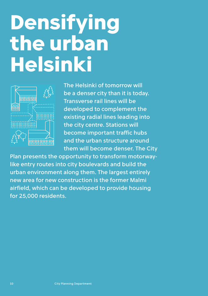
Densifying the urban Helsinki
The Helsinki of tomorrow will be a denser city than it is today. Transverse rail lines will be developed to complement the existing radial lines leading into the city centre. Stations will become important traffic hubs and the urban structure around them will become denser. The City
Plan presents the opportunity to transform motorwaylike entry routes into city boulevards and build the urban environment along them. The largest entirely new area for new construction is the former Malmi airfield, which can be developed to provide housing for 25,000 residents.
10 City Planning Department

The Pasila–Vallila–Kalasatama axis, which follows Teollisuuskatu, will become a significant business district comparable to the current city centre. Teollisuuskatu will become the main street of eastern central Helsinki, connecting the new centres of Pasila and Kalasatama. Along the axis there lie the business districts of Vallila and Tukkutori, Sörnäinen Metro station, the Konepaja area and Suvilahti cultural centre, surrounded by denselybuilt residential neighbourhoods. From Pasila, the
densely built city centre expands to the north and further in the direction of Käpylä.
The City Plan also supports supplementary construction in many of central seaside areas, such as Hakaniemenranta and the southeastern shore of Katajanokka. In Katajanokka, it is possible to obtain new residential space for slightly more than 2,000 inhabitants bythesea by rearranging the existing thoroughfares and parking lots in the harbour. Hakaniemi will become an important public transport node once the Laajasalo tram line is completed, possibly to be complemented later by the Pisararata rail line. Development in the area will be boosted by the overhaul of Hakaniemi bridge. This will facilitate supplementary construction and enable the development of shoreline areas. In the city centre, densification of the urban structure will also include supplementary construction inside city blocks.
Expanding the city centreThe City Plan presents the opportunity to develop a strong new business district in eastern central Helsinki.
An impressive tower area is being planned in central Pasila north of Helsinki city centre.
Helsinki City Plan 11

The development of city boulevards is primarily about the extension of central Helsinki. Valuable green areas can be preserved by using the protective zones of motorwaylike areas for construction. The city boulevards will constitute new urban districts that will feature a mixed urban structure consisting of housing, jobs and services.
The transformation of motorwaylike thoroughfares into boulevards requires investments in public transport and solutions for increasing the popularity of walking and cycling. They must be presented as genuine alternatives for getting around the city. There will also be space left for those who need to drive their own cars. The aim is to develop a functional and safe traffic system that emphasises sustainable modes of transport rather than forcing private cars out of Helsinki.
The character of the existing motorwaylike thoroughfares will be changed by their transformation into boulevards for living and working. They will evolve from routes conveying fast automobile traffic into streets that serve multiple modes of transport. City boulevards will serve public transport, pedestrians and cyclists, as well as motorists. Helsinki also has main streets resembling city boulevards, such as Mannerheimintie and Mäkelänkatu.
Speed limits on the city boulevards will be lower than on the existing entry routes. Some multilevel junctions will be replaced by level
intersections. To ensure smooth traffic flow, it is important, however, to be able to utilise multilevel junctions at certain points where the traffic is particularly heavy. Likewise, smooth crossings must be implemented at points where light rail lines and bicycle paths intersect with city boulevards.
All entry routes to Helsinki inside Ring I can be transformed into city boulevards in the future. The Vihdintie and Itäväylä city boulevards will extend to the city border, as they are already quite streetlike. In addition to the entry routes, Laajasalontie is designated a city boulevard in the City Plan.
New districts along boulevards
One of the major land use solutions in the City Plan is the opportunity to transform motorwaylike thoroughfares into city boulevards inside Ring I.
Dense block along future urban boulevard.
12 City Planning Department

Motorway-like entry routes in HelsinkiAmount of vehicles year 2014
Highway Itäväylä
49 000 vehicles/ weekday
Highway Vihdintie
28 000 vehicles/ weekday
Highway Turunväylä
38 000 vehicles/ weekday
Highway Lahdenväylä
56 000 vehicles/ weekday
Highway Hämeenlinnanväylä
48 000 vehicles/ weekday
Highway Tuusulanväylä
30 000 vehicles/ weekday
Street Laajasalontie
23 000 vehicles/ weekday
Highway Länsiväylä
69 000 vehicles/ weekday
An image of the northern part of Pikku Huopalahti. A view along Mannerheimintie.
13

Developing Local, District and Regional centres in Helsinki
A new commercial centre will be built next to the current one. Later, Laaja-sa lontie will be transformed into a city boulevard, with a significant amount of supplementary construction along it.
The centre of Hertto niemi around the Metro station will develop into a diverse hub of housing, services and jobs. The Herttoniemi business district will remain primarily in commercial use.
The centre of Malmi will be developed into the centre of northeastern Helsinki. The objectives for the development include creating more lively urban space as well as better streets, and attracting residents, services and jobs into the centres, close to the stations.
The Kannelmäki station area will be condensed further and its functional link with the Kaari shopping centre will be improved.
The Oulunkylä station area and the area along Käskynhaltijantie will be densified. RaideJokeri tranversal lightrail line will make Oulunkylä station a rail transport junction.
The Pitäjänmäki station area will be condensed and new residential construction will be introduced at the public transport junction.
14 City Planning Department

The City Plan offers Helsinki the opportunity to develop active and vibrant centres in suburban areas as well.Local and district centres can only develop if they have a sufficiently large population base. An adequate number of residents in a sufficiently dense environment creates the conditions for the availability of diverse services. The local, district and regional centres will have a mixed urban structure with streetside businesses. Itäkeskus is an important regional centre, whereas Malmi is a major district centre. Local centres such as Herttoniemi and Kannelmäki play a key role for its residents.
Itäkeskus has been growing continuously and is already now a very lively hub. The City Plan allocates significant new construction potential to Itäkeskus. According to a sketch proposal prepared for the area, the supplementary construction potential for both residential and business premises in Itäkeskus amounts to one million square metres of floor area.
Malmi is a district centre in the northeast of Helsinki and is an important junction in the urban rail network. Malmi has great growth potential and may become a major business and administration centre as rail connections gain importance and the area becomes more accessible with the arrival of the new transversal lightrail line Jokeri 2. The development of the Malmi airfield area will expand the population base of the area.
Kannelmäki is an important local centre in western Helsinki. The City Plan strengthens the position of the neighbourhood around the Kannelmäki station, giving it the status of a large business and service centre. In this way, the consumer goods retail services away from the area around the station can be better tied to the station centre.
Plans have already been prepared for the centre of Herttoniemi, where the business and residential building base will expand significantly. Herttoniemi is a local centre for the southeastern suburbs. Some 100,000 people live in its impact area. The centre of Herttoniemi can be extended towards the city centre by covering portions of Itäväylä and Metro.
The main objectives for the development of these centres include creating more lively urban space as well as better streets, attracting new inhabitants and jobs to the immediate vicinity of the stations.
Local, District and Regional centres
The development of Myllypuro, which is already well underway, will continue. The campus of the Metropolia University of Applied Sciences will be completed next to the Metro station. The future introduction of the Science Tram will link Myllypuro to the network of higher education institutes.
The centre of Kontula will be developed as a hub of commercial services, offices and housing.
The centre of Vuosaari will grow denser and become more multifunctional. The centre of Vuosaari and Vuosaari Harbour will be connected by rail.
Construction is planned for the centre of Viikki, along the RailJokeri light rail line. The aim is to better connect the surrounding districts with each other.
The potential for supplementary construction in Itäkeskus amounts to as much as one million square metres of floor space.
Helsinki City Plan 15

A Network city
As the population grows, so does the number of journeys made. Helsinki wants to promote sustainable modes of transport, such as walking, cycling and public transport, as genuinely competitive alternatives to the extensive use of private cars. The traffic network in the City Plan is based on a light rail network. Preparations are also made for the expansion of the Metro and railway system.
The light rail lines will extend radially from the city centre to at least Ring I, primarily along boulevard corridors. Some of the lines will go on as far as the city border. Transverse lines connect the radial lines into a traffic network. The current crosstown bus lines Jokeri 1 and 2 will be transferred onto lightrails, significantly improving
transverse connections. A new archipelago tram route via Laajasalo to Vartiosaari and thence via Ramsinniemi towards MeriRastila in the district of Vuosaari, some 14 kilometres to the east, would render the seaside areas of the city better accessibility by public transport.
A new street connection linking Mäkelänkatu and Hämeentie streets is to be opened solely for public transport in Vallilanlaakso, just north of the city centre. The new public transport street enables more efficient use of the existing public transport lines and the setting up of new connections. The new connection will be utilised by the socalled science tram line which links Meilahti and Otaniemi (in Espoo) with Kumpula and possibly Myllypuro in the east of the city.
In order to function, a densely built city requires an efficient public transport system.
The metro and RaideJokeri are essential elements of future railway traffic in Helsinki.
16 City Planning Department

The Malmi airfield is the largest new construction area in the City Plan.
With potential to build homes for 25,000 Helsinki residents, the total floor area target is 1.2 million square metres, of which 100,000 square metres would be allocated to business premises and services. Once this area is developed, it will have a significant impact on the district centre of Malmi and the entire northeastern Helsinki. The aim is to create a new district with a strong local centre of its own.
There are tram lines planned to serve the Malmi airfield area. In future, the area will be a junction for the transverse RaideJokeri 2 lightrail line and a line that goes from the city
centre north via Viikki and through the airfield area. On the main Lahdenväylä motorway in the northeast of the city and across Lahdenväylä in Kivikko, the planned new Tattarisilta junction will also provide the area with a better connection to the street network of eastern Helsinki.
The planned area will be a highquality district with a diverse population structure and wide range of housing options. The plans include preparations for locating some 2,000 jobs in the area. The planning of the Malmi area takes into consideration the local strengths, such as echoes of the airfield’s old runways, open spaces and far away views. The green network in the area is intended to be connected to the Kivikko recreational park by a bridge built over Lahdenväylä. A continuous circular outdoor recreation trail is also part of the plans for the area.
Malmi airfield to be developed into a new city district
Helsinki City Plan 17

Life in a growing Helsinki
The City Plan is necessary for Helsinki to respond to housing demand in the coming years. Housing prices have risen rapidly due to supply not being able to keep up with
demand. At the same time, the growth of the amount of living space per person has stalled. People in Helsinki live in closer quarters than the rest of Finland and pay more for housing. The City Plan also aims to ensure that as it grows and becomes denser, Helsinki will remain a pleasant maritime city that is close to nature, a city that provides good conditions for business activity and has a thriving urban culture.
18 City Planning Department
1985
1990
1995
2000
2005
2010
2014
25
30
35
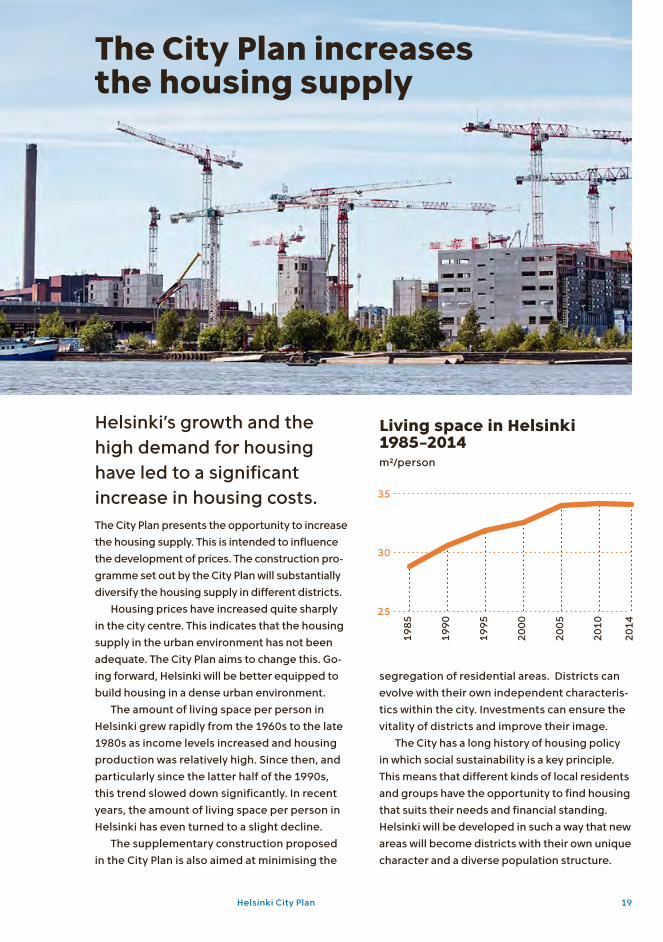
Helsinki’s growth and the high demand for housing have led to a significant increase in housing costs.The City Plan presents the opportunity to increase the housing supply. This is intended to influence the development of prices. The construction programme set out by the City Plan will substantially diversify the housing supply in different districts.
Housing prices have increased quite sharply in the city centre. This indicates that the housing supply in the urban environment has not been adequate. The City Plan aims to change this. Going forward, Helsinki will be better equipped to build housing in a dense urban environment.
The amount of living space per person in Helsinki grew rapidly from the 1960s to the late 1980s as income levels increased and housing production was relatively high. Since then, and particularly since the latter half of the 1990s, this trend slowed down significantly. In recent years, the amount of living space per person in Helsinki has even turned to a slight decline.
The supplementary construction proposed in the City Plan is also aimed at minimising the
Living space in Helsinki 1985–2014m²/person
The City Plan increases the housing supply
segregation of residential areas. Districts can evolve with their own independent characteristics within the city. Investments can ensure the vitality of districts and improve their image.
The City has a long history of housing policy in which social sustainability is a key principle. This means that different kinds of local residents and groups have the opportunity to find housing that suits their needs and financial standing. Helsinki will be developed in such a way that new areas will become districts with their own unique charac ter and a diverse population structure.
Helsinki City Plan 19

The sea has a strong presence in Helsinki. The city’s marine character is one of its major strengths. Helsinki offers the opportunity for seaside living as well as taking advantage of the sea in both economic activities and in recreation. The sea plays a significant role in the City Plan. One of the theme maps of the City Plan shows the beaches and islands allocated for recreational use, for in s tance. It also shows the seaside trail which significantly improves the accessibility of the sho reline to pedest rians and cyclists. You can get to the shore almost anywhere in Helsinki, and the majority of the shoreline is accessible to the public.
The islands off Helsinki also present new op por tunities. Islands previously used by the defence administration have already been released for civilian use, with more to follow in the future.
Such islands include Vallisaari, Kuninkaansaari, Kuivasaari and Isosaari. The aim is to open up the islands for recreational use. Vallisaari and Kuninkaansaari islands are located only a few kilometres from the city centre of Helsinki and from the new Jätkäsaari, Kalasatama and Kruunuvuorenranta areas under construction.
The development of Vallisaari, Kuninkaansaari, Kuivasaari and Isosaari will be carried out in a manner that will respect the islands’ cultural and military history as well as their wild nature. In Isosaari, the existing infrastructure – roads, harbours, power lines, sanitation and a wastewater treatment plant – makes possible the imp lemen tation of other facilities, such as an oil spill response centre, on the island.
The city’s location by the sea opens many de velopment opportunities for Helsinki: from general tourism, wilderness safaris and recreational fishing to improving the maritime infrastructure and accessibility of the archipelago.
A City by-the-sea
Islands for recreational use off the coast of Helsinki
Kuivasaari Isosaari
KuninkaansaariVallisaari
Image of Vallisaari.
20 City Planning Department
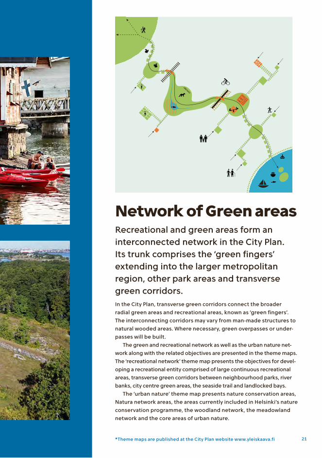
Recreational and green areas form an interconnected network in the City Plan. Its trunk comprises the ‘green fingers’ extending into the larger metropolitan region, other park areas and transverse green corridors.In the City Plan, transverse green corridors connect the broader radial green areas and recreational areas, known as ‘green fingers’. The interconnecting corridors may vary from manmade structures to natural wooded areas. Where necessary, green overpasses or underpasses will be built.
The green and recreational network as well as the urban nature net work along with the related objectives are presented in the theme maps. The ‘recreational network’ theme map presents the objectives for developing a recreational entity comprised of large continuous re creational areas, transverse green corridors between neighbourhood parks, river banks, city centre green areas, the seaside trail and landlocked bays.
The ‘urban nature’ theme map presents nature conservation areas, Natura network areas, the areas currently included in Helsinki’s nature conservation programme, the woodland network, the meadowland network and the core areas of urban nature.
Network of Green areas
*Theme maps are published at the City Plan website www.yleiskaava.fi 21

A mixed urban structure is often a good operating environment for businesses, but commercial zones have their advantages.
The economic activities in such areas will include businesses that cannot be situated in a mixed urban structure because of
accessibility requirements, because their production processes cause great inconvenience to people or because businesses benefit from proximity to each other.
Commercial zones need to be large enough and allow for growth of the companies. In Helsinki, there are two largescale commercial zones outside the city core which are easily accessible by public transport. These are Pitäjänmäki and Herttoniemi–Roihupelto.
A City of diverse business premises
Business areas in Helsinki
Tattariharju
Viikki
Metsälä
Kurkimäki
Kivikko
Tattarisuo
Suutarila Heikinlaakso
Malmi
Tapanila
The area along Vihdintie in Konala
Reimarla
Pitäjänmäki
Vallila industrial zone
The Tukkutori area in Kalasatama
Herttoniemi
22 City Planning Department

An urban city of culture
Helsinki is already a fascinating stage of urban culture. A wide variety of events take place in Helsinki’s districts. Wellknown events such as the Restaurant Day and Cleaning Day started this way, along with various small and large events and phenomena that arise from the community spirit among local residents.
A more urban Helsinki means more streetlevel shops in blocks of flats, bicycle
lanes, the clatter of trams, coffee at the market place, international flavour, urban productivity, seaside saunas and district festivals. The higher population and workplace density enable easy access to local services. Intertwining housing, jobs and services more closely with each other will enable the development of vibrant urban environments, even outside the city centre.
The Helsinki of 2050 is a boldly urban city. The successful cities of the future are cities that residents enjoy and people elsewhere want to move to.
A work of art entitled Unelma
(“Dream”) at Sitra square in
Kannelmäki.
Helsinki City Plan 23

24 City Planning Department

Helsinki City Plan 25

Urban development themes in Helsinki
The Helsinki of the future is a city that is successful in the international competition between cities. It is a city that offers good connections to the world and is an attractive location for businesses. A
denser city offers economies of agglomeration to businesses along with an effective job market. Helsinki will also ensure that it operates in line with the principles of sustainable development. Helsinki’s goal is to be a carbon neutral city by 2050.
26 City Planning Department

114 174NorthAmerica
AsiaEurope and the Middle East
0
5
10
15
1995 2000 2005 2010 2015
20142011 2012 2013
0
5
10
15
114 174Pohjois-Amerik-kaan
AasiaanEurooppaanja Lähi-itään
0
5
10
15
1995 2000 2005 2010 2015
20142011 2012 2013
0
5
10
15
The Helsinki city region is the engine that powers development throughout Finland. International connections are essential for the region’s vitality. Without effective connections, Helsinki cannot serve businesses that operate in the global markets, attract international labour and students, or be an appealing tourist destination.
The City Plan helps ensure that Helsinki has the necessary conditions in place for international connections and their development. In maritime transport, traffic between Tallinn and Helsinki will grow rapidly in the coming decades in terms of passenger traffic as well as cargo and cars. The City Plan ensures that the Port of Helsinki continues to have the necessary conditions for effective operation of its harbours in the city centre and in Vuosaari.
Finland’s location in the northernmost part of Europe makes air traffic particularly signi
Number of passengers at Helsinki-Vantaa Airport 1995–2015millions of passengers
Direct scheduled flight destinations from Helsinki-Vantaa Airport in 2015
Global Helsinki
ficant. Helsinki has developed into a strong hub for air traffic between Europe and Asia. No other city in Northern Europe offers the range of direct flights to Asian metropolises that Helsinki does. The City Plan supports the development of connections between Helsinki’s city centre and the international airport, as well as the supply of business premises. HelsinkiVantaa Airport is currently implementing a significant investment programme that enables the growth of passenger volume.
Helsinki’s city centre is the international display window of the metropolitan area. Tourists are an important target group and Helsinki wants to build itself a profile as an attractive travel destination. Cruise ships bring significant tourist flows right into the heart of the city.
Helsinki City Plan 27

1993
1998
2003
2008
2013
2016
100
150
125
175
Helsinki city centre is the most important commercial centre in Finland. It is comprised of multiple historical layers and is highly acces sible. The City Plan aims to ensure that the city centre will maintain its strong position in the future.
Measured by productivity, the city centre is one of the top areas in the country. Keeping the city centre vibrant is important for the entire Finnish economy. The economies of agglomeration is an important concept for urban productivity.
As firms in related fields of business cluster together, they will have greater specialisation and division of labour, resulting in a significant increase in productivity. The conditions for an effective labour market are better when there is a higher ava i lability of labour, a sufficient pool of skilled and competent people and opportunities for specialisation. This development also presents opportunities to the members of the labour for ce. The growing number of businesses creates more diverse opportunities to find a job that suits one’s needs, education and experience. The growing number of businesses also leads to gre ater division of work between them, while competition leads to costs remaining under control, higher quality and increased productivity.
The City Plan ensures that the land userelated conditions for the economies of agglomeration are in place. The city plan ners of Helsinki have been aiming to strengthen the city’s densely built centre for a long time. For years, the city centre has been growing inwards. New business premises have been built in courtyards and below street level. This has enabled the expansion of the existing central business district. Opportunities for such developments, along with investments in the city centre, will continue to be available in the future.
In the City Plan, the city centre is developed as a functionally mixed area of metropolitan uses, housing, commercial and public services, offices, administration, parks, recreational and outdoor services and urban culture. Ground floor premises and premises that open into the street should be preferably designated as retail or office space. Sustainable modes of transport, particularly pedestrian and bicycle traffic, will be favoured.
The development of rents for office premises in Helsinki’s city centre rent index, 1993 = 100
Economies of agglomeration in a denser city
Source: Helsinki Region Trends/KTI Property Information
28 City Planning Department

1993
1998
2003
2008
2013
2016
100
150
125
175
0
1000
2000
3000
4000
1990
2000
2010
2015
Helsinki is committed to significantly reducing climate emissions.
Helsinki aims to achieve a 30% reduction in climate emissions by 2020 and carbon neutrality by 2050. The City Plan is one of the key instruments for achieving this goal.
Land use planning is directly linked to traffic emissions. The more fragmented the community structure, the higher the emissions. The City Plan sets out a path towards a denser urban structure, with population growth allocated to areas that are effectively served by public transport. This substantially reduces trafficrelated climate emissions compared to alternative
growth scenarios. The alternative would be for the region’s population growth to be dispersed over an increasingly large geographical area of urban sprawl, which would increase the need for more journeys between the outer regional areas and the city, and, in particular, private car traffic, which in turn, would increase emissions.
Besides traffic, Helsinki’s other significant sources of greenhouse gas emissions include the production and consumption of energy. With respect to emissions reduction methods related to the energy system, the City Plan plays a role in facilitating various lowemission solutions and development paths. Achieving emissions reduction targets will require a multidisciplinary strategic planning effort, to which the City Plan will introduce the land use planning perspective.
Towards a carbon neutral Helsinki
Helsinki’s greenhouse gas emissions are declining: emissions in Helsinki 1990–20151000 tonnes CO²eq., source: HSY
Helsinki City Plan 29

Planning process and decision- making
The making of the City Plan has been an open and interactive process that has taken more than four years. A large amount of experiencebased information has been collected from citizens. This is important, as the
City Plan will have a very longterm impact on the city’s development. The process has been made more challenging by the fact that the City Plan represents a new kind of strategic Plan. On the one hand, the wider city centre area now becomes an inclusive area defined as ‘metropolitan mixeduses’, and on the other hand, the outer suburbs are more loosely described as landuses. The City Plan divides Helsinki into onehectare squares, with the primary intended purpose of land use presented for each.
30 City Planning Department
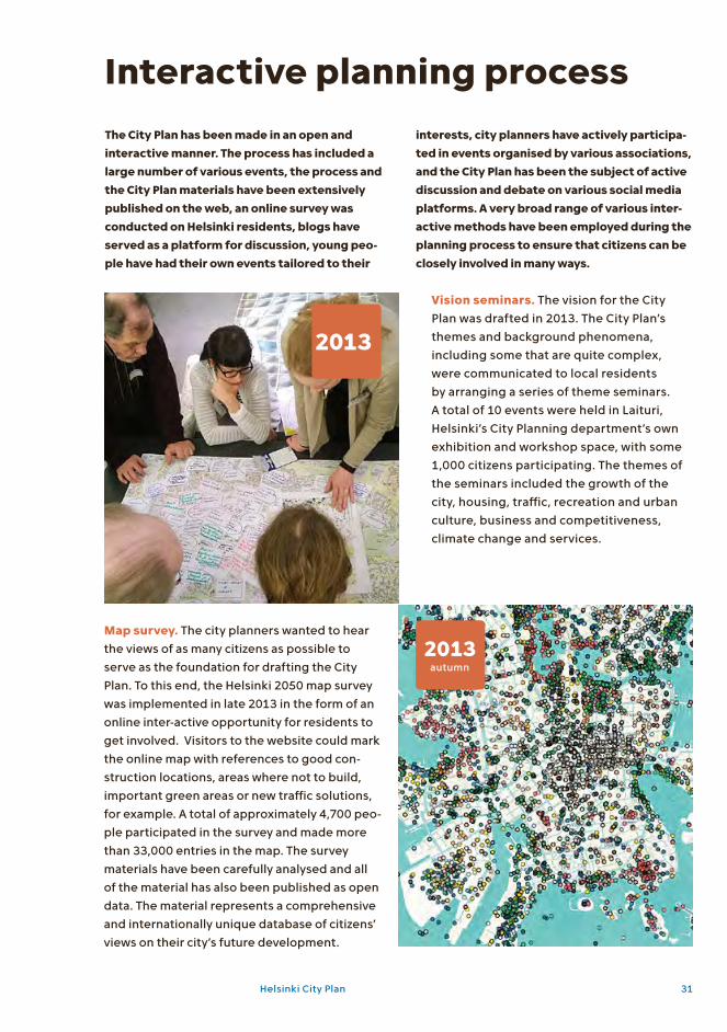
Vision seminars. The vision for the City Plan was drafted in 2013. The City Plan’s themes and background phenomena, including some that are quite complex, were communicated to local residents by arranging a series of theme seminars. A total of 10 events were held in Laituri, Helsinki’s City Planning department’s own exhibition and workshop space, with some 1,000 citizens participating. The themes of the seminars included the growth of the city, housing, traffic, recreation and urban culture, business and competitiveness, climate change and services.
Map survey. The city planners wanted to hear the views of as many citizens as possible to serve as the foundation for drafting the City Plan. To this end, the Helsinki 2050 map survey was imple mented in late 2013 in the form of an online interactive opportunity for residents to get involved. Visitors to the website could mark the online map with references to good construction locations, areas where not to build, important green areas or new traffic solutions, for example. A total of approximately 4,700 people participa ted in the survey and made more than 33,000 entries in the map. The survey materials have been carefully analysed and all of the material has also been published as open data. The material represents a comprehensive and internationally unique database of citizens’ views on their city’s future development.
2013
2013autumn
Interactive planning processThe City Plan has been made in an open and interactive manner. The process has included a large number of various events, the process and the City Plan materials have been extensively published on the web, an online survey was conducted on Helsinki residents, blogs have served as a platform for discussion, young peo-ple have had their own events tailored to their
interests, city planners have actively participa-ted in events organised by various associations, and the City Plan has been the subject of active discussion and debate on various social media platforms. A very broad range of various inter-active methods have been employed during the planning process to ensure that citizens can be closely involved in many ways.
Helsinki City Plan 31

Spend a moment as a city planner. A series of workshops titled Spend a moment as a city planner were arranged in spring 2014. The purpose of the workshops was to work together with local residents to think about what Helsinki should be like in 2050. The aim was to obtain good ideas from Helsinki residents to support the planning process. The workshops were attended by 250 participants who prepared 27 plans, which were then made available to the public via the City Plan website and in Laituri exhibition space. The workshop outcomes were also published on the City Plan website blog, where they have been read by nearly 2,000 local residents.
City Planning Safaris. The City Planning Safaris in January–April 2014 were aimed at determining the opinions of young people regarding Helsinki’s future and the city planners’ vision. A total of 167 students from seven upper secondary schools participated. Four weekend workshops were held to think about the Helsinki of the future and identify solutions to urban planning challenges. The workshops particularly focused on generating ideas related to the future of Siilitie, Pakila, Malmi and Mäkelänkatu. A total of 33 young people participated in the weekend workshops.
Spend a moment as a critic. Four Spend a moment as a critic events were organised in Laituri in January 2015. The events introduced the key contents of the City Plan to those in attendance. The participants had the opportunity to talk to the city planners next to maps related to their particular areas of interest. Each event had approximately 10 map stations with city planners in attendance. The four events attracted a total of some 350 local residents. The matters discussed at the events were largely related to the regional land use changes facilitated by the City Plan.
2014spring
2014January–
April
2015January
32 City Planning Department

The City Council approved Helsinki’s new City Plan at its meeting on 29 October 2016 after extended debate and several votes on key issues. Proposals to redraft the City Plan were voted down by a clear margin. A proposal to exclude minor changes to a fringe area of Central Park from the new City Plan was voted down 55–30 and other counterproposals were voted down by even larger margins. Nearly 150 statements by politicians were made during the debate, which lasted over six hours. The aspects that aroused the most discussion were the fate of Central Park changes and the Malmi airfield, as well as the transformation of motorwaylike entry routes into boulevards.
City Plan decision made by the City Council of Helsinki
2016October
Helsinki City Plan 33

Follow Helsinki’s planning in social media
/helsinkisuunnittelee
/ksvhelsinki
/helsinkisuunnittelee
Websites related to the City Planwww.yleiskaava.fi official city plan websiteyleiskaava.maptionnaire.com/fi/ the results of the city plan map survey
Publication information
This publication provides condensed information on Helsinki’s new City Plan 2050. The City Plan was approved by the City Council of Helsinki on 26 October 2016.
Brochure textHelsinki City Planning Department
Visual design of the publication seriesKokoro & Moi
Helsinki Plans 2017:1ISSN 07879075
Graphical implementation of the publicationLagom
PrintingFram, Vaasa
PhotosS. 2 KSV; s. 4 Pertti Nisonen; s. 5 KSV; s. 8–9 Simo Karisalo; s. 11 3D Render; s. 10, 18, 26, 30 Jari Miranda; s. 12–13 Serum Arkkitehdit; s. 14 Simo Karisalo, Kimmo Brandt; s. 16 WSP Finland, Jyrki Heinonen; s. 17 KSV; s. 19 Roni Rekomaa; s. 20 Roni Rekomaa, Tuomo Häyrinen; s. 23 Roni Rekomaa, Simo Karisalo; s. 24–25 Roni Rekomaa; s. 27 Kimmo Brandt; s. 28 Roni Rekomaa; s. 29 Jussi Hellsten; s. 31 KSV; s. 32 KSV, Anu Hämäläinen; s. 33 Pertti Nisonen.
AppendixCity Plan Map
More information about the planning of Helsinki
34 City Planning Department


City of Helsinki City Planning Department
Visiting addressKansakoulukatu 300100 HelsinkiMailing addressP.O. Box 2100 00099 City of HelsinkiTel.09 310 1673www.hel.fi/ksv

Helsinki City Plan
Scale 1 : 60 000Scale of original urban plan map is 1:30 000
0 1 2 3 km
Primarily residential area A1The area is developed for housing, commercial and public services, business premises, parks, recreational services and outdoor services. The block density will primarily exceed 1.8. Along key streets in the area, the street-level floors of buildings must feature retail space and other business premises. At least 60% of the total area is arranged into blocks.
Primarily residential area A2The area will be developed primarily for housing, parks, recreational and outdoor ser-vices, and local services. The block density is primarily 1.0–2.0. Block density may be even higher where justified. The development of retail space and other business premises must be enabled along key streets in the area. An average of 60% or more of the total area is arranged into blocks.
Primarily residential area A3The area will be developed primarily for housing, parks, recreational and outdoor ser-vices, and local services. The block density is primarily 1.0–2.0. Block density may be even higher where justified. An average of 60% or more of the total area is arranged into blocks.
Primarily residential area A4The area will be developed primarily for housing, parks, recreational and outdoor ser-vices, and local services. The block density is primarily under 0.4. An average of 70% or more of the total area is arranged into blocks.
SuomenlinnaThis UNESCO World Heritage Site shall be managed and developed for housing, com-mercial and public services, business premis-es, parks, recreational services and outdoor services, tourism and the defence forces in such a way as to ensure that the site’s world heritage value is not compromised.
Areas reserved for business and office useThe area will be primarily developed for business premises, industrial production, warehou sing, harbour operations, public services, education and recreation. In Roihu-pelto –Herttoniemi, Konala and Suutarila, the detailed plans for the areas designated for this purpose can include regionally signifi-cant large-scale retail units that, taking the nature of their retail operations into account, could also justifiably be located outside the central area. Large-scale consumer goods re-tail units are not allowed. The conditions for business activity will be ensured by alloca-ting a sufficient number of plots for business premises in the detailed plans for areas reserved for commercial and office use.
Technical maintenance areaThe area will be developed for technical maintenance, data communications and traf-fic. The premises and equipment necessary for traffic management and technical mainte-nance may be built in the area.
PortThe area will be developed for harbour oper-ations, jobs and services. The premises and equipment necessary for harbour operations and technical maintenance may be built in the area.
Defence forces areaUsed by the defence forces, the area will be developed for housing, commercial and public services, business premises, parks, rec-reational services and outdoor services if the defence forces’ activities in the area are relo-cated. The restrictions concerning the area affected by the noise from shooting activities in Santahamina must be taken into account in accordance with the Uusimaa regional plan.
Recreational and green areaThe area will be developed as a significant area for recreation, outdoor activity, sports, nature and culture, connected to the regional green network and seaside recrea-tional zones. The forest network presented in the City Plan theme map will be taken into account in developing the recreational
and green areas. The aim is to preserve the forest-like character of the network.
Seaside recreation and tourism areaThe area will be developed as a significant area for recreation, outdoor activity, sports, nature and culture, connected to recreational and green zones on the mainland. Includes areas designated for holiday homes and tourism.
For both recreation and green areas and seaside recreation and tourism areas:Plans must ensure the preservation of cultu-ral, historical and landscape values, as well as take into account areas that are significant with respect to biodiversity, ecosystem ser-vice development, nature conservation, the ecological network and the forest network.
Green corridor A corridor, green axis or series of parks bet-ween large recreational areas whose location is indicative and which serve as recreational and/or ecological connections. In planning areas, green corridors must be intercon-nected in a natural way. The preservation of cultural, landscape and natural values must be taken into account, along with the coherence, continuity and ecological connectedness of the green corridors. The interconnecting corridors may vary from man-made structures to natural wooded areas. Where necessary, green overpasses or underpasses will be built.
Seaside trailA seaside trail that covers the entire city along the shoreline and continues out to the other parts of the region.
Water area
Railway and stations The locations shown for the rail tunnel to Tallinn and the direct airport rail line are indicative.
Metro and stations
Trunk rail traffic connectionImplemented as Metro or light railway. The location is indicative.
Light railFast public transport trunk connection that can be implemented as a bus service. The location is indicative.
Rail traffic connection requirementThe connection can be implemented as a light rail line, Metro or a railway. A more detailed specification requires an assessment of land use and traffic.
Nationally/regionally important road or street with multi-level junctions
City boulevardA traffic route developed as a part of a high-quality urban environment in the increasingly dense urban structure. The city boulevard serves drivers, public transport, pedestrians and cyclists. The length and junction solutions will be determined as part of more detailed planning.
Main street
An underground or covered section of a nationally or regionally important road, street, city boulevard or main streetThe location and length are indicative.
Baana networkA high-speed trunk network for bicycle traf-fic. The location is indicative.
Line is drawn 30 metres outside the area that the decision concerns. The City Plan covers the City’s administrative area ex-cluding Östersundom.
In the entire planning area
The areas comprised of squares reflect the primary land use. The areas are not strictly delineated by boundaries. The land use of adjacent areas subject to different plan regulations will be matched with each other to create a functional and effective urban structure. The continuity of green fingers as well as other regional green areas and the local green area network must be ensured.
In the planning of all areas covered by the city plan, functionality, economy, ecological sustaina-bility, health, safety, housing needs and business needs will be taken into consideration, along with the accessibility of services, making use of the existing community structure.
The conditions for pedestrians and cyclists will be improved throughout the city, as will accessi-bility by public transport.
Landscapes of national value and built cultural environments of national significance must be taken into account, with legal effect, based on the Cultural Environments theme map. Planning must also take into account regionally and locally signifi-cant landscape areas and cultural environments and their particular characteristics, as well as sites pro-tected under the Finnish Antiquities Act. Planning must reconcile the land uses indicated in the plan with landscape and cultural environment values.
Natura 2000 network areas, nature conserva-tion areas and areas designated for protection in the City of Helsinki Nature Protection Programme 2015–2024 must be taken into account, with legal effect, based on the Urban Nature theme map. Rec-reational and ecosystem services will be developed. Planning must take into account areas that hold significant value for nature conservation and biodi-versity, and such value must be preserved.
offices, administration, parks, recreational and outdoor services and urban culture. Ground floor premises and premises that open into the street should be preferably designated as retail or office space. Changes to the uses of buildings or their parts must ensure that they preserve the functionally diverse and mixed structure that is charac-teristic of the city centre, as well as the suf-ficient availability of retail and office space. Changes to intended uses must include an area assessment. Sustainable modes of transport, particularly pedestrian and bicycle traffic, will be favoured. In the areas borde-ring on city boulevards, the block density should primarily exceed 1.8 and, along key streets, ground floor premises and premises that open into the street should be primarily designated as retail or office space.
Local centre C3A centre developed as a functionally mixed area of commercial and public services, offices, administration, housing, parks, recreational and outdoor services and urban culture. Centrally located ground floor prem-ises and premises that open into the street should be primarily designated as retail or office space. The area is pedestrian-domi-nated. The area stands out from its environ-ment as more dense and diverse. Regionally significant retail stores must not be located in local centres. This does not, however, refer to complexes comprised of shops on the street-level floors of buildings.
In all types of centresThe centres will be densified and developed as urban city structure. In planning centres, special attention must be paid to the pedes-trian scale as well as the effectiveness of the arrangements made for pedestrians, cyclists, parking, maintenance traffic and public transport. Parking spaces must be primarily located in parking facilities and along streets. In more detailed planning, adequate areas must be allocated to ensure appropriate public transport transfer locations and park and ride facilities.
Large retail units must be integrated with housing, services or other such functions, and the street-level floors of buildings must open up to the street. Large units must be supported by public transport trunk connec-tions. The scaling of large consumer goods retail units must be based on local demand. The number of parking spaces will be limited.
Large-scale consumer goods retail units must not be built outside centres.
Premises and equipment that serve technical maintenance in the community can be located in any type of area. The city centre can include large energy production facilities. The area reservations for areas to be built and areas that have already been built include regional energy and water sup-ply networks and related facilities along with their protective zones.
The shoreline is indicative. The shorelines will be planned as public areas in the new construction areas.
Precautions for flooding must be taken into account in plans for areas that are close to the sea or other waterways. Planning must take stormwater management into account. A stormwater manage-ment system must be drafted in conjunction with land use changes that involve significant impacts.
This City Plan does not replace the existing local plans for Jätkäsaari, Central Pasila, Sörnäistenranta and Hermanninranta, Kuninkaantammi, the eastern part of northern Haaga and Kruunuvuorenranta, nor does it replace the local plans for Vartiosaari, the western shore of Meri-Rastila, Koivusaari and Hernasaari, provided that the local plans in ques-tion become valid before this City Plan.
The underground City Plan, with legal effect, is valid for the areas covered by the City Plan except the Katajaharju tunnel, Heli track, Merikannon-tie–Mechelininkatu tunnel, Kalasatama tunnel, Maratontie tunnel, Pitäjänmäenkaari tunnel and Paceliuksenkatu–Nordenskiöldinkatu tunnel.
The interpretation of the City Plan is presented in the Written Statement for the Plan*.
*Theme maps are published at the City Plan web-site www.yleiskaava.fi
Business and service centre C1A business, retail and service centre deve-loped as a functionally mixed area of commer-cial and public services, offices, administra-tion, housing, parks, recreational and outdoor services and urban culture. Ground floor premises and premises that open into the street should be primarily designated as retail space. The area is pedestrian-dominated. The area stands out from its environment as more dense and functionally diverse. The total amount of retail and office space should not, as a rule, be reduced. Changes to the uses of buildings or their parts must ensure that they preserve the functionally diverse and mixed structure that is characteristic of the centre. Changes to intended uses must include an area assessment.
City centre C2Developed as a functionally mixed area of housing, commercial and public services,