City of Austin Urban Trails Master Plan...Urban Trail Design Considerations City of Austin Urban...
19
City of Austin Urban Trails Master Plan April 2014 City of Austin Urban Trails Master Plan Tuesday April 1, 2014
Transcript of City of Austin Urban Trails Master Plan...Urban Trail Design Considerations City of Austin Urban...

City of Austin
Urban Trails Master Plan
April 2014
City of Austin Urban Trails Master Plan Tuesday April 1, 2014

Agenda:
• Definition of an Urban Trail
• Urban Trail Master Plan Goals
• Existing Urban Trails
• Public Input
• Design Criteria and Considerations
• Prioritization Matrix
City of Austin Urban Trails Master Plan Tuesday April 1, 2014

Definition of an Urban Trail
• Included in 2009 Bicycle
Master Plan,
• Follows Imagine Austin,
• Considers definitions used by
other communities, and
• Confirmed by Citizen
Advisory Group and Technical
Advisory Group.
A citywide network of non-motorized, multi-use pathways
that are used by bicyclists, walkers and runners for both
transportation and recreation purposes.

Urban Trail Goals for Austin
1. Provide easy access to urban trails for both transportation and recreation users.
2. Connect urban trails to the on-street bicycle network, sidewalk network, transit stops and bike share stations.
3. Ensure adequate trail width to accommodate both recreation and transportation uses.
4. Incorporate trail amenities and features that create unique, whimsical greenways.
5. Provide adequate funding and resources for maintenance and operations.
6. Ensure that all urban trails are context-sensitive and environmentally sustainable.
City of Austin Urban Trails Master Plan Tuesday April 1, 2014
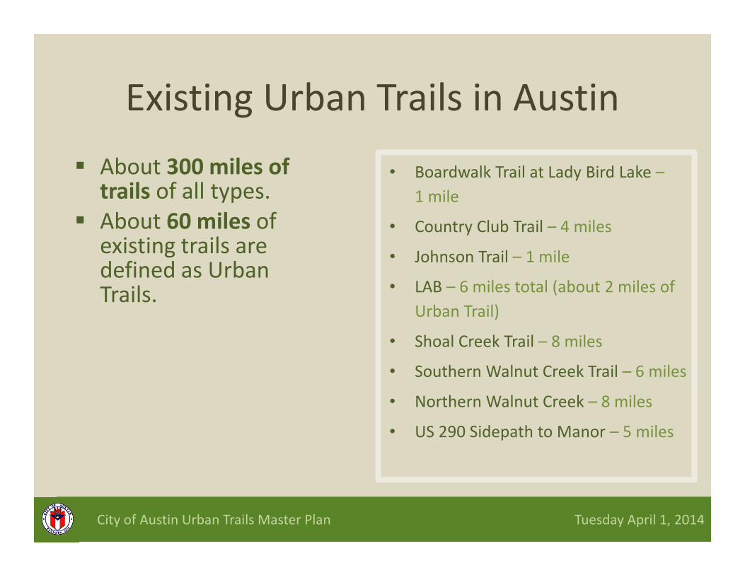
Existing Urban Trails in Austin
� About 300 miles of trails of all types.
� About 60 miles of existing trails are defined as Urban Trails.
• Boardwalk Trail at Lady Bird Lake –
1 mile
• Country Club Trail – 4 miles
• Johnson Trail – 1 mile
• LAB – 6 miles total (about 2 miles of
Urban Trail)
• Shoal Creek Trail – 8 miles
• Southern Walnut Creek Trail – 6 miles
• Northern Walnut Creek – 8 miles
• US 290 Sidepath to Manor – 5 miles
City of Austin Urban Trails Master Plan Tuesday April 1, 2014

Urban Trails in Austin

Public Input on Urban Trails
City of Austin Urban Trails Master Plan Tuesday April 1, 2014
• Telephone survey (statistically relevant survey): 603 respondents
• Austin Urban Trail User survey: 189 respondents
• Online survey: 2,392 respondents
• 5 public meetings
– Questionnaire: 105 respondents
– Online Open House survey: 66 respondents

Public Input on Urban Trails
23% of adults ride
a bike often
3% ride daily
City of Austin Urban Trails Master Plan Tuesday April 1, 2014
Over 75% of Kids
Ride Bikes in Austin
41% of Adults
Ride Bikes in Austin

Public Input on Urban Trails
City of Austin Urban Trails Master Plan Tuesday April 1, 2014
54% of people in Austin
want to ride more
94% of bike enthusiasts feel
comfortable riding on an Urban Trail
50% feel comfortable riding in a
traditional striped bike lane

A path or trail that is separate from a
street
A residential street with low speed traffic
AND a wide bicycle lane separated from
traffic by a raised curb
A major urban street AND a wide bicycle
lane separated from traffic by a raised curb
A residential street with low speed traffic
AND bicycle route markings, speed humps
and other traffic calming designs.
A neighborhood street with low speed
traffic AND a striped bicycle lane.
Very comfortable Somewhat comfortable Somewhat uncomfortable Very uncomfortable
Public Input Scenario Preferences

Public Input on Urban TrailsTop 7 barriers preventing people from riding a bike
Weather is too hot
Destinations too far
You do not feel safe
Bicycle lanes, trails are not connected
Lack of shade
Bicycle lanes, trails are not available
Takes too long
City of Austin Urban Trails Master Plan Tuesday April 1, 2014

Public Input on Urban TrailsMost Important Potential Improvements
City of Austin Urban Trails Master Plan Tuesday April 1, 2014
Widen Trail
surfaces
Add Lighting Separate areas for
walkers and
bicyclists
Improve smoothness
of trails
Improve Access

The Austin Urban Trail
City of Austin Urban Trails Master Plan Tuesday April 1, 2014
Southern Walnut Creek Trail
Criteria
Minimum Width 12’
Minimum Shoulder 2’
Min. Vertical Clearance 10’
Maximum Cross Slope 2%
Maximum Grade 5% (8.25 % with
handrails)

Dual Track Urban Trail
City of Austin Urban Trails Master Plan Tuesday April 1, 2014
Source: American Trails
Source: American Trails
Criteria
Minimum Width 8’ for pedestrian side
10’ for bicyclist side
Minimum Shoulder 5’ user separation
2’ shoulder
Vertical Clearance 10’
Maximum Cross Slope 2%
Maximum Grade 5%

Urban Trail Design Considerations
City of Austin Urban Trails Master Plan Tuesday April 1, 2014
• Include connections to surrounding neighborhoods,
businesses, places of employment, other trails, on-street
network, public transit stops, bike share stations.
• Install lighting where appropriate to enhance security
and nighttime accessibility.
• Design for environmental preservation:
• Preserve trees or vegetation closer to the trail,
• Incorporate scenic overlooks or pull-offs,
• Incorporate smaller curve radii to preserve the scenic qualities
of the corridor, and
• Watershed Protection Ordinance supports Urban Trails.

Other Urban Trail Considerations
City of Austin Urban Trails Master Plan Tuesday April 1, 2014
• Plan for security presence and emergency access
• Location Markers & Wayfinding
– Orientation, distance, and travel time,
– Provide safety information, and
– Educate about trail etiquette.
• Promote and provide incentives for development of Urban Trail segments and connections
• Create a sense of place
– Engage the community

Urban Trail Corridors – Prioritization Criteria
Criteria Level of
Importance
(Weighting)
� Environmental considerations 3x
� Citizen support 2x
� Constructability 2x
� Corridor availability 2x
� Connectivity to Active Transportation Network 2x
� Connectivity to transit 2x
� Connectivity to local destinations/neighborhoods 2x
� Scenic qualities 1x
� Area population density 1x
� Helps overcome gap or barrier 1x
� First in its area of the City 1x
• Uses a point system.
• Criteria are weighted to emphasize importance.

Priority Urban Trails

Timeline for
Implementation
• April 8 – East ANC and Urban Transportation Commission
• April 14 – Land, Facilities, and Programs Committee (Parks and Recreation Board)
• April 15 –Bicycle Advisory Council
• April 16 – Environmental Board
• April 22 – Parks and Recreation Board
• May 1 – City Council (set public hearing)
• May 13 – Planning Commission
• May 22 – City Council (conduct public hearing)