City of Arkadelphia - · PDF fileFigure A5.3 Primary Factors Affecting Low Flow on Ouachita...
46
Non-Riparian Permit Report A R K A N S A S W A T E R P L A N A R K A N S A S W A T E R P L A N City of Arkadelphia NON-RIPARIAN INTRA-BASIN TRANSFER OUACHITA RIVER DIVERSION Technical Report & Recommendation Arkansas Natural Resources Commission Sun-Bio Project
Transcript of City of Arkadelphia - · PDF fileFigure A5.3 Primary Factors Affecting Low Flow on Ouachita...

Non-Riparian Permit Report
A R K A N S A S
W A T E R
P L A
N
A R K A N S A S
W A T E R
P L A
N
City of Arkadelphia
NON-RIPARIAN INTRA-BASIN TRANSFER
OUACHITA RIVER DIVERSION
Technical Report & Recommendation Arkansas Natural Resources Commission
Sun-Bio Project

City of Arkadelphia Non-Riparian Permit
Table of Contents
TABLE OF CONTENTS
Executive Summary ………….…………………..…………………………………………………….. i
Project Description ……………………………………………………………………………............ i
Permit Considerations ………………………………………………………………………….......... ii
Streamflow …………………………………………………………………………………………………….. ii
Excess Surface Water ….………………………………………………………………..……………….. iii
Environmental Impacts ………………………………………………….………………..……………… iii
Potential Limitations …….………………………………………………………………..……………… v
Recommendations .……….……………………………………………………………………........... vi
A. TECHNICAL ANALYSES …………………………………….…………………………………..... 1
A.1 Available Excess Surface Water ……..……………………………..………………………. 1
Statewide ………………….……………….……………………………………..……………………………. 1
Ouachita River Basin ………………….……………………………………..……………………………. 3
A.2 Subbasin Data …….………………………..…..………………………..……………………….. 5
Controlled & Uncontrolled Drainage Areas ………………………..…………………………… 5
Ouachita River Morphology ….………….………………………………..…………………………… 6
Caddo River Morphology .………………….………………………………..………………………….. 7
Climate Factors ……………….……………………………………….…….……………………………….. 8
A.3 Existing Non-Riparian Use ………..………………………..…………..………………………. 16
Upper Ouachita River Subbasins ………...……………………………..…………………………… 16
A.4 Stream Flow Description ………………..………………………………..………………………. 18
Remmel Dam Releases ………………………...……………………………..…………………………… 18
DeGray Dam Releases …………………………..………………………………………………………….. 20
Arkadelphia Gage ..…..………….……………………………………..…………………………………… 22
A.5 Environmental Considerations ………………………………………..………………………. 24
Instream Resources .….………………….…...……………………………..…………………………… 24
Drought Contingency …………………….…...……………………………..…………………………… 27
Low Flow Condition .………………….…....…..…………………………..…………………………… 28

City of Arkadelphia Non-Riparian Permit
Table of Contents
TABLE OF CONTENTS
B. AGENCY COORDINATION ….………..……..………………………………………………..... 31
C. PERMIT RECOMMENDATIONS …………………...……..…………………………………. 31
C.1 Curtailment ………………………………………….….……………………………..………………………. 31
C.2 Length of Permit ……………………………….….……………………………..………………………. 31
C.3 Site-Specific Gaging ……..……………….….……………………………..…………….……………. 32
C.4 Reporting Requirements …………….….……………………………..……………..……………. 32
List of Tables
Table ES1 Project Withdrawal & Discharge Quantities …..………………………..………………… i
Table ES2 Withdrawal Rates vs. Ouachita River Flow …………………………..…………………… iii
Table ES3 Permit Monitoring Action Plan ………………………………………………..………………… viii
Table A1.1 Available Excess Surface Water (Ouachita River Basin)…………………..…..……… 4
Table A2.1 Available Excess Surface Water (Ouachita River Subbasins)……….……………… 5
Table A2.2 Temperature and Precipitation ………………………………………………………………… 10
Table A3.1 Active Non-riparian Permits Upstream from Proposed Projects ……………… 17
Table A4.1 Minimum Flow Requirements at Remmel Dam …………………..………………… 19
Table A4.2 Stage Flow Rating Table: Ouachita River at Arkadelphia ………..………………… 22
Table A5.1 Mussel Species in the Ouachita River.. …………………………………..………………… 25
Table A5.2 Palmer Drought Index …………….……………………………………………..………………… 27
Table A5.3 Entergy Drought Contingency Plan Workgroup……………………..………………… 28
City of Arkadelphia Non-Riparian Permit
Table of Contents
TABLE OF CONTENTS
List of Figures
Figure ES1 Diversion Location ……………………………………....………………………..…………..…….. ii
Figure ES2 Excess Surface Water ………………………………....………………………..…………..…….. iii
Figure ES3 Limitation Factors ……………………………………....………………………..…………..…….. v
Figure A1.1 River Basins in Arkansas ………………………....………………………..…..………..…….. 1
Figure A1.2 Excess Surface Water Diagram ………………....………………………..…………..…….. 2
Figure A1.3 Ouachita River Basin Delineation …………....………………………..…………..…….. 3
Figure A1.4 Ouachita River Basin: 10-Digit HUC ………....………………………..…………..…….. 4
Figure A2.1 Sun-Bio Project Delineation ……………….…....………………………..…………..…….. 5
Figure A2.2 Ouachita River Stream Profile ……………….....………………………..…………..…….. 6
Figure A2.3 Caddo River Stream Profile …………………....………………….……...…………..…….. 7
Figure A2.4 Temperature: July-December …………..…....………………….……...…………..…….. 9
Figure A2.5 Temperature: January-June ……………..…....………………….……...…………..…….. 10
Figure A2.6 Precipitation: January-June ……….……..…....………………….……...…………..…….. 11
Figure A2.7 Precipitation: July-December ……..……..…....………………….……...…………..…….. 12
Figure A2.8 Runoff: January-June ………………….……..…....………………….……...…………..…….. 13
Figure A2.9 Runoff: July-December ……………….……..…....………………….……...…………..…….. 14
Figure A2.10 Precipitation vs. Runoff …………………..…....………………….……...…………..…….. 15
Figure A3.1 Existing Non-riparian Use within Drainage Areas above Sun-Bio Diversion …….……. 16
Figure A4.1 Remmel Dam Minimum Release …………....………………………..…………..…….. 18
Figure A4.2 Monthly Flow Requirements at Remmel Dam …………………..…………..…….. 20
Figure A4.3 Re-Regulation Reservoir Weir downstream of DeGray Lake Dam ….……... 21
Figure A4.4 Minimum Flow through Re-Regulation Reservoir Weir ……....…………..….... 21
City of Arkadelphia Non-Riparian Permit
Table of Contents
TABLE OF CONTENTS
List of Figures
Figure A4.5 Lowest Recorded Ouachita River Stage …....………………………..…………..…….. 22
Figure A4.6 Average Daily Flow & Arkadelphia (2001-2006) .……………………………..…….. 23
Figure A4.7 Average Daily Flow & Arkadelphia (2006-20011) .………………..…………..……. 23
Figure A4.8 Average Daily Flow & Arkadelphia (2011-2016) .…….…………..…………..…….. 23
Figure A5.1 Example: Intake Head Construction …………..………………..………..………..…….. 26
Figure A5.2 Non-Specific Water Intake Pipe Configuration ……………..……..…………..……. 26
Figure A5.3 Primary Factors Affecting Low Flow on Ouachita River .……..…………..…….. 29
Figure A5.4 Diagram of Ouachita River Projects .………………….……………..…………..…….. 30

City of Arkadelphia Non-Riparian Permit
Executive Summary i
EXECUTIVE SUMMARY
Project Description
The Sun-Bio facility is to be located in the Clark County Industrial Park south of Arkadelphia on
U.S. Highway 67. Overall project development includes: a water intake and transmission
structures, water/wastewater treatment facilities, rail and road improvements, and other
appurtenances necessary to support the Sun-Bio paper manufacturing facility. The facility will
create paper “bio-products”, up to 690,000 air dried metric tons of dried pulp per year, from
Arkansas’ inventory of unused forest dregs, logging leftovers, imperfect commercial trees, dead
wood and other non-commercial trees in existing forests in the Arkadelphia region.
The city of Arkadelphia will operate the project components necessary to provide potable
water and wastewater treatment services to the Sun Bio facility. Water will be withdrawn from
the Ouachita River near Arkadelphia year round and transported to the Clark County Industrial
Park and treated for process and fire flow water to the Sun Bio facility. The proposed project
does not include development of off-stream storage. Water withdrawn and transported from
the Ouachita River will be treated before entering the Sun Bio facility. Water efficiency within
the facility will be maximized to reduce the amount of unused and untreated process water
leaving the plant. Unused process water leaving the facility will be treated and released back
into the Ouachita River. The average release back into the Ouachita River will be 65-80 percent
of the water originally withdraw. The distance between the water intake and water discharge
structures is approximately six miles. Both structures are to be located along the Ouachita
River. Estimated withdrawal and discharge quantities are listed in Table ES1.
Table ES1: Project Withdrawal & Discharge Quantities
Description Withdrawal Rate Discharge Rate
Peak Daily 29 cfs 19 mgd
Peak Hourly 41 cfs 27 mgd/hr
Average Daily 23 cfs 15 mgd
Average Annual 21,230 acre-ft/yr
Net Consumptive 6 cfs
City of Arkadelphia Non-Riparian Permit
Executive Summary ii
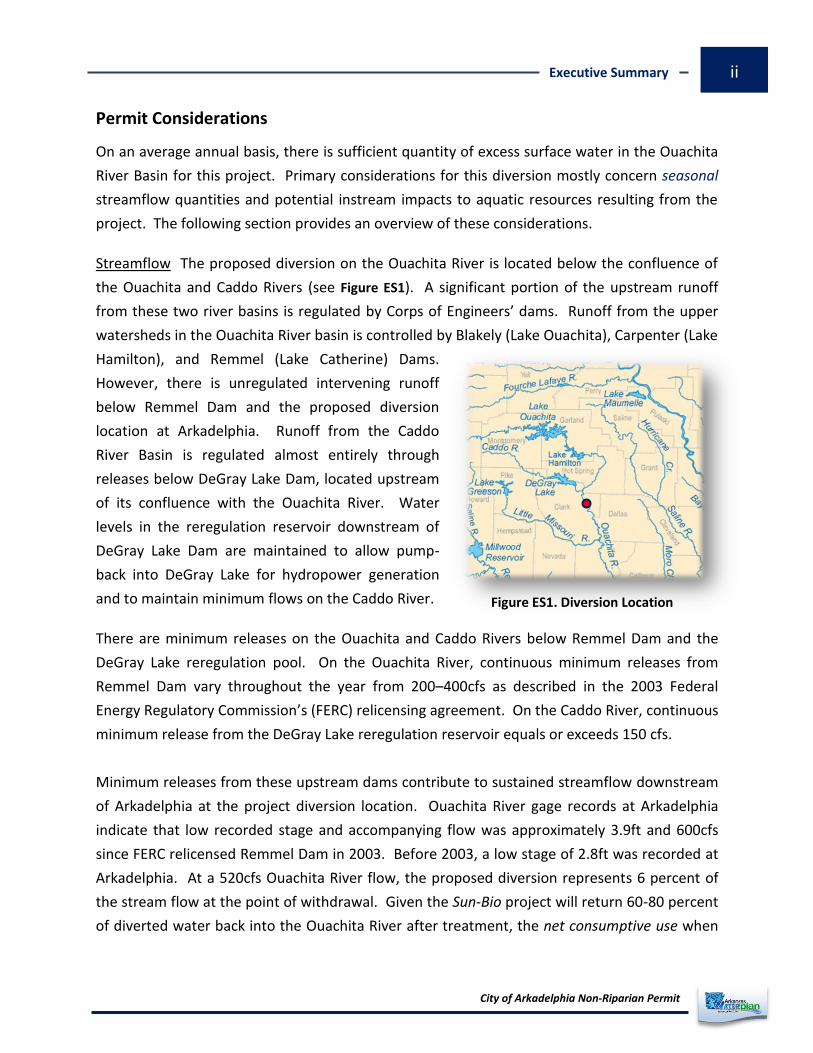
Figure ES1. Diversion Location
Permit Considerations
On an average annual basis, there is sufficient quantity of excess surface water in the Ouachita
River Basin for this project. Primary considerations for this diversion mostly concern seasonal
streamflow quantities and potential instream impacts to aquatic resources resulting from the
project. The following section provides an overview of these considerations.
Streamflow The proposed diversion on the Ouachita River is located below the confluence of
the Ouachita and Caddo Rivers (see Figure ES1). A significant portion of the upstream runoff
from these two river basins is regulated by Corps of Engineers’ dams. Runoff from the upper
watersheds in the Ouachita River basin is controlled by Blakely (Lake Ouachita), Carpenter (Lake
Hamilton), and Remmel (Lake Catherine) Dams.
However, there is unregulated intervening runoff
below Remmel Dam and the proposed diversion
location at Arkadelphia. Runoff from the Caddo
River Basin is regulated almost entirely through
releases below DeGray Lake Dam, located upstream
of its confluence with the Ouachita River. Water
levels in the reregulation reservoir downstream of
DeGray Lake Dam are maintained to allow pump-
back into DeGray Lake for hydropower generation
and to maintain minimum flows on the Caddo River.
There are minimum releases on the Ouachita and Caddo Rivers below Remmel Dam and the
DeGray Lake reregulation pool. On the Ouachita River, continuous minimum releases from
Remmel Dam vary throughout the year from 200–400cfs as described in the 2003 Federal
Energy Regulatory Commission’s (FERC) relicensing agreement. On the Caddo River, continuous
minimum release from the DeGray Lake reregulation reservoir equals or exceeds 150 cfs.
Minimum releases from these upstream dams contribute to sustained streamflow downstream
of Arkadelphia at the project diversion location. Ouachita River gage records at Arkadelphia
indicate that low recorded stage and accompanying flow was approximately 3.9ft and 600cfs
since FERC relicensed Remmel Dam in 2003. Before 2003, a low stage of 2.8ft was recorded at
Arkadelphia. At a 520cfs Ouachita River flow, the proposed diversion represents 6 percent of
the stream flow at the point of withdrawal. Given the Sun-Bio project will return 60-80 percent
of diverted water back into the Ouachita River after treatment, the net consumptive use when

City of Arkadelphia Non-Riparian Permit
Executive Summary iii
134,877
42,275
211,620
Excess Surface Water (acre-ft/yr)
Remmel Dam
DeGray Lake Dam
Project Diversion
measured downstream of the discharge to the Ouachita River represents approximately 1
percent of 520cfs. A summary of diversion and streamflow quantities is shown in Table ES2.
Table ES2. Withdrawal Rates vs. Ouachita River Flows
Project Withdrawal Rates Percent of 525cfs Ouachita River Flow at Arkadelphia
Withdrawal Location Discharge Location*
Peak Daily Rate 29.4 cfs 5.6% 1.2%
Peak Hourly Rate 41.3 cfs 7.9% 3.5%
: Discharge of 22.7cfs into Ouachita River is approximately 6 miles downstream of withdrawal location. Note
Excess Surface Water Available non-riparian
excess surface water in Ouachita River
Basin totals 705,401 acre-feet per year
based on the total average annual basin
yield. Figure ES2. includes annual excess
surface water quantities at gages on the
Ouachita River upstream of the proposed
project diversion. Since the instantaneous
quantity of excess surface water physically
available for the proposed project at any
given time is largely controlled by releases upstream, availability or lack of availability is
dependent on operations at Remmel and DeGray Lake dams.
Environmental Impacts In general, potential effects from construction and operation of the
proposed project are described here as either land or water resource impacts. Evaluation of
some potential impacts that could result from the project will require other state or federal
regulatory processes to be completed and are beyond the ANRC’s capacity to investigate.
However, further environmental assessment and impact studies may be required to secure
non-ANRC state and federal permits. Any additional information or data generated through
non-ANRC regulatory processes subsequent to this report will be reviewed and included into
the non-riparian permit file, and if appropriate, will be recognized and incorporated into ANRC’s
permit governing this non-riparian water use.
Figure ES2. Excess Surface Water Quantities

City of Arkadelphia Non-Riparian Permit
Executive Summary iv
Construction activities associated with the Sun-Bio facility, water/wastewater treatment plants,
river intake, transmission lines, and other appurtenances will cause localized, and in most cases,
temporary disturbances to land resources. These disturbances to jurisdictional lands, whether
temporary or permanent, will be regulated and mitigated through federal regulatory processes.
Potential environmental impacts to land resources are assumed to be non-significant to ANRC’s
review and evaluation of the proposed non-riparian water use.
Many fish and mussel species have been documented in the Ouachita River between the mouth
of the Caddo and the Little Missouri Rivers, including four mussel species that are federally
listed as endangered or threatened. Potential entrainment of these aquatic species in the
water column and disturbance of river bed materials near the water intake are concerns that
affect the design and configuration of the diversion structure. The Arkansas Department of
Environmental Quality’s (ADEQ) National Pollutant Discharge Elimination System (NPDES)
permitting process includes regulation of cooling water intakes for pulp, paper, and paperboard
mills with a design flow greater than 2 MGD. The ADEQ will conduct technical reviews of the
location, design, construction, and capacity of the proposed water intake to ensure: maximum
intake velocities are less than 0.5 feet per second; total design intake flow is less than 5 percent
of the river design technology to minimize impingement mortality; and design technologies to
minimize entrainment and adverse environmental impacts are incorporated into the project.
The ADEQ has verified through preliminary NPDES permit review that preliminary design
configuration of intake structure meets national requirements of Section 316(b) of the Clean
Water Act as referenced above.
Localized effects related to entrainment potential and riverbed disturbance that could
theoretically occur in the immediate area surrounding the intake head cannot be documented
until operation of the intake structure is observed. Once withdrawals commence under normal
operating conditions, monitoring of withdrawals for a specified time period may be required by
non-ANRC regulatory processes to satisfy federal regulatory requirements. At this time, it has
not been documented whether operation of the project will adversely impact endangered or
threatened mussel species that possibly could exist in close proximity to the intake structure.
The net consumptive loss or net reduction in Ouachita River streamflow will be minimal and is
approximated to be 7 cfs. It is assumed any significant environmental impact from reduction in
streamflow will occur in the approximately six mile stretch of Ouachita River between the
project’s water intake and discharge locations. As shown in Table ES2, the amount of diversion

City of Arkadelphia Non-Riparian Permit
Executive Summary v
represents five percent of 520cfs, the low Ouachita River flow recorded at the Arkadelphia gage
since continuous releases from Remmel Dam began in 2003.
Water quality impacts associated with the project affecting temperature, dissolved oxygen, or
other water chemistry parameters are not determined by ANRC as part of the non-riparian
permitting process. Any water quality issues will be addressed by non-ANRC regulatory and
monitoring processes. Potential requirements or recommendations from non-ANRC regulatory
processes intended to reduce or eliminate possible water quality impacts will be incorporated
into ANRC’s non-riparian permit conditions if appropriate.
Potential Limitations Establishment of project withdrawal limitations requires investigation and
an understanding of the interaction between upstream lake operations, water management
activities, on-site factors, and year-to-year seasonal weather patterns. Releases from Remmel
and Lake DeGray Dams for power generation and flood control functions significantly affect
occurrence and duration of low flows on the Ouachita River downstream. In addition, extreme
weather patterns which generate extended drought and flooding events affect the schedule of
dam releases. For these reasons, withdrawal limitation(s) should be evaluated based on a
“multi-tiered” approach and an evaluation
of the relationship between the following:
upstream dam releases and downstream
flow conditions, runoff & precipitation
(forecasting) data, and potential negative
instream impacts which could result from a
combination of circumstances or series of
events. Figure ES3 shows these factors as
primary influences in determining when
restrictions are warranted. As an example,
when upstream (storage) lake levels
necessitate significant reduction of dam
releases for power generation and minimum
environmental instream flows, restriction of
withdrawals downstream may be warranted
if- flows near the withdrawal location are
judged to be inadequate to sustain aquatic
resources and the replenishment of
upstream lake levels and streamflow from runoff or precipitation is not likely (forecasted) to
Restriction
No Restriction
Downstream Conditions:
Critical Low Flows
Runoff & Precipitation:
Extended Drought
Lake Levels:
Reduction in Dam Releases
Figure ES3 Limitation Factors
Restriction
No Restriction
Downstream Conditions:
Critical Low Flows
Runoff & Precipitation:
Extended Drought
Lake Levels:
Reduction in Dam Releases

City of Arkadelphia Non-Riparian Permit
Executive Summary vi
occur within a specified time period. In this scenario, circumstances and concurrent conditions
would contribute to possible restrictions being imposed on out-of-stream withdrawals in order
to provide a minimum level of protection for instream needs.
Recommendations
Environmental Impacts Annually, there exists sufficient excess surface water in Ouachita River
subbasins upstream of the proposed project to permit this diversion. There is no evidence from
historical period of record flow analyses to indicate this withdrawal, including existing non-
riparian withdrawals upstream, will alter seasonal Ouachita River flow patterns. There remain
some unanswered questions related to potential environmental impacts resulting from the
project. These impacts are more closely associated with physical conditions existing in the six
mile stretch of Ouachita River between the intake and discharge locations and in areas
immediately around these two structures during normal withdrawal and discharge operations.
Any environmental impacts that may result from project construction and normal withdrawal
operations should be verified through other non-ANRC regulatory processes. Recommended
actions to address potential environmental impacts associated with construction and start-up
of the project under non-critical (average or above) Ouachita River flows are included below:
Stream Flow The net consumptive use will be unmeasurable when comparing Ouachita River
flow upstream of the intake and downstream of the discharge structures. Therefore, the six
mile stretch of Ouachita River between the intake and discharge structures will experience a
loss of flow equal to the amount of diversion at the intake structure. This loss is quantified in
Table ES2 and equals five to eight percent of 520cfs, which is representative of low recorded
Ouachita River flow at Arkadelphia since continuous minimum release at Remmel Dam began in
2003. A multi-triggered monitoring action plan is recommended to evaluate and verify
concurrent conditions which, in combination, result in or are predicted to result in an ANRC
declared and require allocation of surface water withdrawal according to ANRC Rules shortage
for Utilization of Surface Water. A is defined as a condition when all beneficial water shortage
uses cannot be met.
relevant data from federal or other non-ANRC regulatory Evaluate and incorporate
environmental assessment processes into non-riparian permit conditions if construction or
normal operation of the project would be affected by results from these data. As well, if
monitoring of project withdrawals is required to complete non-ANRC regulatory processes, all
monitoring data should be evaluated for inclusion into the permit if necessary.

City of Arkadelphia Non-Riparian Permit
Executive Summary vii
Table ES3 contains the recommended Permit Monitoring Action Plan (PMAP) which identifies
conditions affecting streamflow at Arkadelphia and the downstream withdrawal location. The
PMAP is the check-list to verify: a) multiple conditions (triggers) exist or are forecasted to exist
or remain in the future, and b) a combination of these existing or forecasted circumstances and
conditions may require management action(s) from ANRC and the permittee. The conditions
described in the PMAP will be evaluated by ANRC to determine the net impact of the project on
instream environment and existing in-situ streamflow conditions. The permittee is responsible
for monitoring conditions on the Ouachita River at the Arkadelphia gage and upstream to the
extent necessary to fully coordinate and comply with ANRC during a declared when shortage
restriction of out-of-stream withdrawals may be necessary. Table ES3 contains red, yellow, and
green text corresponding to colored bars on either side of the table. This color scheme is
intended to mimic a theoretical staff gage on an unnamed stream, colored to indicate levels
when restrictions on withdrawals would occur, i.e. stage level in red would represent restriction
or shut-off. Likewise, corresponding items colored red within Table ES3 represent concurrent
conditions that have to exist in order for ANRC to consider restrictions on project withdrawals.
Recommended actions to address impacts and effects of project withdrawals on Ouachita River
during periods of low flow and other critical conditions are listed below:
Incorporate Permit Monitoring Action Plan (PMAP) into the final permit to describe
trigger thresholds and other considerations ANRC will use to evaluate shortages in Ouachita
River subbasins which could affect normal project operations and withdrawals from the
Ouachita River.
if any, and incorporate into Determine site-specific stream monitoring requirements,
the non-riparian permit after all non-ANRC regulatory processes have been completed. ANRC
will use site-specific gaging, if installed, to evaluate shortages in Ouachita River subbasins and
implement surface water allocation during a shortage.

City of Arkadelphia Non-Riparian Permit
Executive Summary viii
Table ES3. Permit Monitoring Action Plan: City of Arkadelphia Non-Riparian Permit
Location(s) Existing Condition (Trigger) ANRC Management Action(s)
Remmel Dam DeGray Lake Dam Arkadelphia Gage
Existing conditions at all sites above trigger thresholds
None
DeGray Lake Dam (Average Daily Flow)
(Weir) <150 cfs
1) Contact Vicksburg District Corps of Engineers to verify operational deviations at DeGray Lake Dam and document existing conditions
2) Document average daily releases from Remmel Dam
3) Document average daily flow at Arkadelphia gage
Remmel Dam (Average Daily Flow)
(Jan-Feb) <200cfs (March) < 400cfs (April) < 350cfs (May) < 250cfs (June-Nov) < 200cfs (Dec) < 250cfs
1) Contact Entergy Corporation to verify deviation in minimum flow releases at Remmel Dam and document existing conditions at Blakely Dam
2) Document average daily flow at DeGray Lake Dam
3) Document average daily flow at Arkadelphia gage
Arkadelphia Gage Average Daily Stage <4 ft 1) Check conditions at DeGray Lake and Remmel Dams
2) Verify precipitation stats and forecasts
Remmel Dam DeGray Lake Dam Arkadelphia Gage
1) Existing conditions at all sites meet trigger thresholds
2) Entergy implements drought contingency planning
1) Compare project withdrawals and Ouachita River flows
2) Document precipitation statistics and forecast 3) Evaluate conditions existing at all sites and
implement restrictions if determined necessary 4) Coordinate ANRC action with Entergy’s drought
contingency planning efforts
Permittee Management Responsibilities- Maintain a monitoring system capable of reporting instantaneous and average daily withdrawal rate(s) to ANRC when requested, complying with permit provisions and annual compliance reporting, and adhering to provisions in Title 3 Rules for Utilization of
Surface Water.

City of Arkadelphia Non-Riparian Permit
Executive Summary ix
Permit Issuance In addition to annual compliance and reporting, overall project operations
affecting withdrawals from the Ouachita River should be re-evaluated at least every 10 years to
confirm existing permit conditions are appropriate and project withdrawals are not adversely
impacting instream or other resources in Ouachita River subbasins. The frequency of re-
evaluation should coincide with expiration dates on non-riparian permit. A provisional permit
should be issued initially to remain in effect until construction and start-up of project, federal
regulatory, environmental assessment, and permitting processes are completed. A final permit
should be issued when the project begins normal withdrawals from the Ouachita River and
after any environmental monitoring that is required by other non-ANRC processes have been
completed. Recommended actions to address issuance of the final permit and frequency of re-
evaluation are listed below:
(to include any environmental and regulatory data from non-Issue non-riparian permit
ANRC processes once completed) for a period of 25 years, with regular, periodic evaluation of
project withdrawals and permit conditions during this 25 year period. These evaluations will
verify that existing permit conditions remain appropriate and normal project withdrawals are
not negatively impacting instream or other environmental resources in the upper Ouachita
River watershed.

City of Arkadelphia Non-Riparian Permit
Technical Analyses 1
Figure A1.1 River Basins in Arkansas
A. TECHNICAL ANALYSES General analyses were conducted to evaluate water availability in the Ouachita River Basin and
identify potential effects of the proposed Sun-Bio non-riparian diversion on land and water
resources in the watershed. These efforts were focused primarily on water availability and
stream flow analyses within the context of existing ANRC Rules for the Utilization of Surface
Water and enabling Commission authority enumerated in state water law. Additional studies
and review of more detailed project design and proposed operations may be required in other
federal and state regulatory processes. Information and data generated from non-ANRC state
or federal regulatory processes will be reviewed by Arkansas Natural Resources Commission
staff and incorporated into the non-riparian water use permit where appropriate.
A.1 Available Excess Surface Water
Statewide
On an average annual basis, there is estimated to be 8.7 million acre-feet per year of excess
surface water available for interbasin transfer and use by non-riparians. It is important to note-
although there is an abundance of water available on an average annual basis; demand for that
water does not necessarily occur during times of the year when the water is physically
available. Therefore, streamflow variability and possible reoccurring seasonal and multi-year
flow patterns need to be identified when determining physical availability of water at individual
locations within a specific basin or sub basin.
Excess surface water is quantified statewide by 9
river basins and 32 sub basins in the recent 2014
Arkansas Water Plan update (see Figure A1.1). The
amount of surface water available for non-riparian
use is defined as excess surface water in ANRC Title
3, Rules for the Utilization of Surface Water. Title 3
specifies excess surface water will be calculated
from the average annual basin yield, existing uses,
instream flow, and future water demands. Excess
surface water is quantified as 25 percent of the total
available water summarized in the 2014 Arkansas
Water Plan. Total available water is the amount of
water over and above what is required to meet both instream and out-of-stream water needs.

City of Arkadelphia Non-Riparian Permit
Technical Analyses 2
Instream needs are quantified by the Arkansas Game & Fish Commission’s Arkansas Method
and is the highest of instream flow considerations in most basins.
Figure A1.2 divides total average annual basin yield (runoff) among in-stream and out-of-stream
needs (demand) and total available water (potential for future use). Excess surface water in
Figure A1.2 is highlighted in RED and is equal to 25% of Total Available Water on an annual basis.
The 25% is calculated by basin or individual Hydrologic Unit Code (HUC) and represents the
quantity, by basin or HUC, available to permit non-riparian water use.
Figure A1.2 Excess Surface Water Diagram
Existing Riparian Use Federal Projects Projected Future Riparian Use
Basin Yield
In-Stream Needs Excess Surface Water (25% of total available water)
Total Available Water (Potential for future use)
Average Annual
Out-of-Stream Needs
Aquifer Recharge, Fish & Wildlife, Navigation, Water Quality, Recreation, and Interstate Compacts
City of Arkadelphia Non-Riparian Permit
Technical Analyses 3
Ouachita River Basin
The Ouachita River Basin, located in the southwest region of Arkansas, comprises 10,885 square
miles. The Ouachita River Basin includes several subbasins which are delineated in the 2014
Arkansas Water Plan (AWP). In Figure A1.3 below, the Saline River subbasin is delineated within
the Ouachita River Basin for purposes of calculating excess surface water quantities for the Sun-
Bio Project. In determining excess surface water for this project, the 3,230 square mile Saline
River subbasin does not contribute any surface water runoff above the project location and
therefore must be subtracted from the overall Ouachita River Basin area. The remaining
drainage area for the Ouachita River Basin is 7,655 square miles.
The 2014 AWP estimates total excess surface water for 10,885 square miles of the Ouachita
River Basin at 1,349 cubic-feet per second or 977,583 acre-feet per year. The Saline River
subbasin comprises approximately 27 percent of the Ouachita River Basin and excess surface
water for this subbasin is estimated at 272,182 acre-feet per year. Removing the Saline River
subbasin leaves 73 percent of the Ouachita River Basin with excess surface water estimated at
705,401 acre-feet per year. The drainage area above the Sun Bio Project diversion is
approximately 30 percent of the remaining Ouachita River Basin area, which equates to
Figure A1.3 Ouachita River Basin Delineation
City of Arkadelphia Non-Riparian Permit
Technical Analyses 4
211,620 acre-feet per year of excess surface water. The Ouachita River Basin’s 10-digit HUCs
and the Sun-Bio Project drainage area are shown in Figure A1.4.
Table A1.1 contains available annual excess surface water quantities for the Ouachita River
Basin and its subbasins. Annual excess surface water for the Sun-Bio Project is estimated to be
211,620 acre-feet per year.
Table A1.1 Available Excess Surface Water (Ouachita River Basin)
Available Excess Surface Water Drainage Area Acre-Ft/Year
Ouachita River Basin 100% 977,583
Saline River Subbasin 27.8% - 272,182
Ouachita River subbasin 72.2% 705,401
Sun Bio Project 21.6% 211,620
Figure A1.4 Ouachita River Basin: 10-Digit HUC Delineation
City of Arkadelphia Non-Riparian Permit
Technical Analyses 5
Figure A2.1 Sun-Bio Project Delineation
A.2 Subbasin Data
Controlled & Uncontrolled Drainage Areas
For excess surface water calculation, hydrologic runoff analyses, and assessment purposes, the
Sun-Bio Project subbasin has been delineated as shown in Figure A2.1 and encompasses 2313
square miles originating in the headwaters of the Ouachita River and ending at the project
diversion location near Arkadelphia. The project’s watershed is equivalent to thirty percent
(30%) of Ouachita River subbasin, excluding the Saline River subbasin. Available excess surface
water for this portion of the Ouachita
River subbasin is equivalent to 973
cubic-feet per second or 705,401
acre feet per year. The project’s
drainage area is transected by two
primary river systems and delineated
into the Caddo and Ouachita River
subbasins. Historical period of record
gage data provide analyzes capability
for these two subbasins: 1) 07359002
Ouachita River at Remmel Dam
above Jones Mill, Arkansas, and 2)
07359910 Caddo River at DeGray
Regulating Dam near Arkadelphia,
Arkansas.
Table A1.2 below contains available
excess surface quantities for the two hydrologic subbasins and shows that eighty eight percent
(88%) of the project’s drainage area (runoff) is regulated through Remmel and DeGray Lake
Dams. Approximately twelve percent (12%) of the subbasin drainages are not controlled by
these two dams and thus represents the unregulated portion of flow measured at the
Arkadelphia gage.
Table A2.1 Available Excess Surface Water Quantities (Ouachita River Subbasins)
Drainage Area % of Project Runoff Excess (cfs) Excess (ac-ft/yr)
Above Remmel Dam 1550 mi2 67% 186 134,877
Above DeGray Dam 480 mi2 21% 58 42,275

City of Arkadelphia Non-Riparian Permit
Technical Analyses 6
Ouachita River Morphology
The Ouachita River headwaters are located in western Arkansas at an elevation of
approximately 1572 feet (NAD 83). The stream profile drops 1,402 feet over the course of 196
miles to the diversion location near Arkadelphia. Figure A2.2 shows the Ouachita River stream
profile from the headwaters to the diversion location and includes Blakely Dam which creates
Lake Ouachita, Carpenter Dam which creates Lake Hamilton, and Remmel Dam which creates
Lake Catherine. The stream profile is indicative of Ouachita Mountains terrain and associated
topography.
Figure A2.2 Ouachita River Stream Profile

City of Arkadelphia Non-Riparian Permit
Technical Analyses 7
Caddo River Morphology
The Caddo River headwaters are located in western Arkansas at an elevation of approximately
1148 feet (NAD 83). The stream profile drops 969 feet over the course of 85 miles to the
confluence of the Ouachita River east of Caddo Valley. Figure A2.3 shows the stream profile
from headwaters to the confluence and includes DeGray Dam which creates Lake DeGray and
the Reregulation Dam which creates the Regulating Pool. Headwaters of the Caddo River
mirror similar runoff and slope characteristics consistent with the Ouachita Mountains.
Figure A2.3 Caddo River Stream Profile

City of Arkadelphia Non-Riparian Permit
Technical Analyses 8
Climate Factors
Temperature, precipitation, and runoff are interrelated factors that affect stream flow and lake
level in the Ouachita River Basin. Temperature affects weather patterns and specifically rates
of evaporation from lakes and streams in the basin. Higher temperatures increase the rate of
evaporation. Extended duration and more frequent occurrence of higher temperatures (loss),
in combination with lack of precipitation (recharge), influence significantly water availability on
a seasonal basis. Therefore, seasonal climate and stream flow trends should be identified and
evaluated when data is available. Historical high, low, and average temperatures in the project
watershed are included in Table A2.2 below. Temperature, precipitation, and runoff (lake
storage, etc.) are factors associated with forecasting future drought and intensity of droughts.
These factors may need to be monitored during a declared . Figures A2.4 through A2.9 shortage
on pages 9-14 contain period of record monthly means for temperature, precipitation, and
runoff in the project subbasin. Data from NHDPlus Version 2.1 data set was used to create the
maps for these figures.
Figure A2.10 on page 15 correlates annual mean temperature and precipitation with runoff.
Runoff is most critical beginning the end of July and continuing through August, September and
October, which is historically when temperatures are warmest and precipitation lowest. These
months represent the time of year when climatic conditions have the greatest potential for
affecting Ouachita River flow in the project subbasin.
Table A2.2 Temperature and Precipitation
Temperature (Fahrenheit)
High (annual) 74.2°
Low (annual) 49.8°
Average 62°
Annual Precipitation Mean
57.1 Inches

City of Arkadelphia Non-Riparian Permit
Technical Analyses 9
Figure A2.4 Temperature: July-December

City of Arkadelphia Non-Riparian Permit
Technical Analyses 10
Figure A2.5 Temperature: January-June
City of Arkadelphia Non-Riparian Permit
Technical Analyses 11
Figure A2.6 Precipitation: January-June

City of Arkadelphia Non-Riparian Permit
Technical Analyses 12
Figure A2.7 Precipitation: July-December

City of Arkadelphia Non-Riparian Permit
Technical Analyses 13
Figure A2.8 Runoff: January-June

City of Arkadelphia Non-Riparian Permit
Technical Analyses 14
Figure A2.9 Runoff: July-December

City of Arkadelphia Non-Riparian Permit
Technical Analyses 15
0.00
1.00
2.00
3.00
4.00
5.00
6.00
7.00
8.00
9.00
10.00
Janu
ary
Febr
uary
Mar
ch
April
May
June July
Augu
st
Sept
embe
r
Oct
ober
Nov
embe
r
Dec
embe
r
Mea
n M
onth
ly A
vera
ge
(Yea
rs re
cord
ed 1
970
-200
0)(In
ches
)
Precipitation Versus Runoff
Run Off Precipitation
39.244.1
52.3
60.2
68.1
75.780.2 79.1
72.3
61.5
50.4
41.9
0.0
10.0
20.0
30.0
40.0
50.0
60.0
70.0
80.0
90.0
Janu
ary
Febr
uary
Mar
ch
April
May
June July
Augu
st
Sept
embe
r
Oct
ober
Nov
embe
r
Dec
embe
r
Mea
n M
onth
ly A
vera
ge T
empe
ratu
re (Y
ears
197
0 -2
000)
(Fah
renh
eit)
Temperature
Figure A2.10 Precipitation vs.Runoff

City of Arkadelphia Non-Riparian Permit
Technical Analyses 16
A.3 Existing Non-Riparian Use
Upper Ouachita River Subbasins
The ANRC Non-Riparian Water Use Program holds five active permits within the 2,313.75
square mile delineated watershed drainage area upstream of the proposed (Sun Bio) project
diversion on the Ouachita River (see Figure A3.1 for locations of these five diversions). Four of
the five active permits collectively divert 91,900 acre-feet per year within a 37 mile segment
(length) of the Ouachita River. Of those five diversions, MN06-13 is the northern most
diversion located on Lake Hamilton between Blakely and Carpenter Dams. Permits 02-13, 01-
11, and 00-10B are both located below Remmel Dam. The one remaining active permit, 1687-
13 diverts 61 acre-feet per year from the Caddo River and is located upstream of Lake DeGray
and Lake DeGray Dam.
Table A3.1 on the following page provides a listing of active non-riparian permits located in the
drainage area above the proposed Sun Bio project. Each listing provides the Name of the
Permittee, Date the permit was issued, Water Source, Latitude (decimal degrees), Longitude
(decimal degrees), Drainage Area in square miles above diversion location (if known), Estimated
Low Flow in cubic feet per second (if known), Estimated Daily Discharge of the water source in
cubic feet per second (if known), Maximum Diversion Rate in cubic feet per second of the
diversion, and the Annual Maximum Permitted Volume in acre-feet per year.
Figure A3.1 Existing Non-riparian Use within Drainage Areas above Sun Bio diversion

City of Arkadelphia Non-Riparian Permit
Technical Analyses 17
Table A3.1 – Active Non-riparian Permits Upstream from Proposed Project
NRWU Permit MN06-13 Permittee: City of Hot Springs Date of Issuance: 01/27/2014
Source Latitude Longitude Drainage Area
Estimated Stream Flow Conditions
Max Diversion Rate Max Annual Volume Permitted Low Flow Daily Average
Lake Hamilton 34.549925 -93.183721 1,103.85mi2 56cfs 1,460cfs 36cfs 22,420 acre-ft/year
The City of Hot Springs, Arkansas is permitted to withdraw 30 million gallons per day (MGD) from Lake Hamilton, not to exceed an average of 20 million gallons per day (MGD) within a rolling 3-month period.
NRWU Permit 02-13 Permittee: James Kimzey Regional Water District Date of Issuance: 05/13/2002
Source Latitude Longitude Drainage Area
Estimated Stream Flow Conditions
Max Diversion Rate Max Annual Volume Permitted Low Flow Daily Average
Ouachita River 34.432 -92.8787 - - - 39cfs 28,000 acre-ft/year
The James Kimzey Regional Water District depends on two water sources to supply its system. This diversion is for the Ouachita River at Jones Mill (Kimzey East). The projected need for potable water supplied by Kimzey East is 12 million gallons per day (MGD). The District is also under contract with Hot Spring Power Company, L.L.C. (HSPC) to supply 6 MGD of raw water from the Ouachita River to a 720 megawatt (MW) power generating station northwest of Malvern. The proposed generation station could expand to 1500 MW, at which time the full capacity of 12 MGD of raw water will be required. To meet the combined needs of the District, the permitted diversion is for 28,000 acre-feet per year.
NRWU Permit 00-10 B Permittee: Malvern & Quad-County Public Facilities Board Date of Issuance: 05/15/2000
Source Latitude Longitude Drainage Area
Estimated Stream Flow Conditions
Max Diversion Rate Max Annual Volume Permitted Low Flow Daily Average
Ouachita River 34.393611 -92.840555 - - - 38cfs 26,885 acre-ft/year
The City of Malvern and the Quad County Public Facilities Board is permitted to withdraw a maximum of 24 million gallons per day (MGD) from the Ouachita River for municipal water supply.
NRWU Permit MN06-13 Permittee: Entergy Arkansas, Inc. Date of Issuance: 09/21/2000
Source Latitude Longitude Drainage Area
Estimated Stream Flow Conditions
Max Diversion Rate Max Annual Volume Permitted Low Flow Daily Discharge
Ouachita River 34.302458 -92.61711 - - - 20cfs 14,600 acre-ft/year
Entergy Arkansas’s is permitted to withdraw 13 MGD to support a 620 Megawatt (MW) natural gas-fired combined-cycle Hot Springs generating plant, 5 miles southwest of Malvern, Arkansas. The largest consumption in the power plant is make-up water for the cooling system, whose water is primarily used in a surface condenser to cool and condense low energy steam. The low energy steam is used to drive a steam turbine, and after condensation, the water is returned to the steam generator system.
NRWU Permit 1687-13 Permittee: Glenwood Country Club Date of Issuance: 07/09/2013
Source Latitude Longitude Drainage Area
Estimated Stream Flow Conditions
Max Diversion Rate Max Annual Volume Permitted Low Flow Daily Discharge
Caddo River 34.32415 -93.533978 1,103.85 21cfs 17cfs 1cfs 61 acre-ft/year
The diversion is for Glenwood Country Club in Glenwood, Arkansas to withdraw a maximum of 61 acre-feet per year from the Caddo River. The water withdrawn is stored in holding ponds and ultimately used to irrigate the fairways and greens.

City of Arkadelphia Non-Riparian Permit
Technical Analyses 18
A.4 Stream Flow Description
Remmel Dam Releases
Entergy, prior to the FERC licensing agreement of 2003, was allowed to withhold and reduce
water releases from Remmel Dam in order to maximize power generating capacity through
management and maintenance of lake levels upstream. This had an effect of marginalizing
downstream consistency, allowing fluctuations in stream flow throughout any given period of
time. Under the current FERC licensing there is now a requirement for continuous minimum
daily flow which varies by month (see Table A4.1 and Figure A4.1).
Remmel Dam creates Lake Catherine and Carpenter Dam creates Lake Hamilton. The dams and
lakes together form the Federal Energy
Regulatory Commission Project #271. Under
normal conditions, Lake Ouachita levels
slowly fall through hydroelectric generation
through Carpenter and Remmel dams. Lake
Ouachita is then allowed to refill during the
winter months through rainfall. To conserve
water during drought conditions, FERC
licensing allows Entergy to restrict power
generation in the fall season at Remmel and
Carpenter dams, and if necessary through a
request for temporary deviation from Article
401, reduce the flow from Remmel dam
below the normal minimum Federal Energy
Regulatory Commission (FERC) requirements.
The contingency plan allows a reduction in the continuous minimum flow normally required
from Remmel Dam into the Ouachita River to conserve water in Lake Ouachita. In addition,
operations under the FERC license require and authorize Entergy to control certain activities
that affect the lake’s environmental, safety and recreational values.
Should the drought contingency plan be requested, the Licensee can initiate a consultation
meeting during a moderate drought and make recommendations to the Commission. During
extreme drought conditions, Entergy may request the FERC to lower the minimum required
flow by 10%, below the already existing or agreed upon reduced rate of 200cfs by an additional
10%, to a new minimum of 180cfs, if agreed upon by the Commission.
Figure A4.1 Remmel Dam Minimum Release

City of Arkadelphia Non-Riparian Permit
Technical Analyses 19
The drought plan is written such that it is implemented at Entergy’s option once the Moderate
or Severe Drought trigger is met. This option would likely be exercised if it were late in the
summer, fall or spring when there is a desire to refill Lake Ouachita and they are ready to stop
generating power. The exact level of Lake Ouachita is a variable and would be a management
decision at the time a critical decision is made on whether to continue to generate and thus pull
the lake down further, or to stop generation and allow it to refill. This Entergy option, once
implemented, imposes limitations on generation to emergency system needs only. Decisions
will be affected based on an evaluation of the level of the lake versus the desire to continue
generation which does not allude to a specific lake level.
Minimum flow requirements (without hydropower generation), as specified in the FERC license
for Remmel Dam, are shown below in Table A4.1.
Monthly minimum flow requirements described above and contained in Entergy’s drought
contingency plan are shown in Figure A4.2. These flows represent potential incremental
reductions in minimum flow from Remmel Dam during drought conditions. Entergy would
reduce minimum flows at Remmel Dam in order to conjunctively manage levels in Lakes
Ouachita, Hamilton, and Catherine. A full description of Entergy’s drought contingency
responsibilities and guidelines is contained in a later section of this report.
Table A4.1 Minimum Flow Requirements at Remmel Dam
Month Minimum Flow Requirement
January 300cfs
February 300cfs
March 400cfs
April 350cfs
May 250cfs
June-November 200cfs
December 250cfs
City of Arkadelphia Non-Riparian Permit
Technical Analyses 20
0
50
100
150
200
250
300
350
400
Required flow cfs- normal conditions
Minimum flow cfs- moderate drought
Minimum flow cfs- extreme drought
Figure A4.2 Monthly Flow Requirements at Remmel Dam (Entergy’s drought contingency plan)
DeGray Lake Dam Releases
Caddo River streamflow is controlled by a permanent weir in the re-regulation reservoir
immediately downstream of DeGray Lake Dam. The purpose of the permanent weir (low water
dam) is to allow water from the re-regulation reservoir to be pumped back into DeGray Lake
during off-peak times when electricity costs are relatively cheaper, creating the potential to
generate electricity from releases through DeGray Lake Dam when hydropower power is
needed and energy can be produced at a profit. The re-regulating pool has 5 water release
gates, two of which remain open year round to allow a continuous flow of 150cfs out of the re-
regulation reservoir. Figure A4.3 shows the permanent weir structure which controls water
levels in the re-regulation reservoir. Continuous flow through the two open gates is shown in
Figure A4.4.

City of Arkadelphia Non-Riparian Permit
Technical Analyses 21
Figure A4.3 Re-regulation Reservoir Weir downstream of DeGray Lake Dam
150 ft3/sec minimum flow through two gates
Figure A4.4 Minimum Flow through Re-regulation Reservoir Weir
Gates open at all times

City of Arkadelphia Non-Riparian Permit
Technical Analyses 22
0.0
1.0
2.0
3.0
4.0
Figure A4.5 Lowest Ouachita River Stage
Arkadelphia Gage
The term “gage height” or stage (usually measured in feet) is used when referring to elevation
of the water surface as measured at the gaged location. At some gaging stations, rating curves
have been created to develop correlations between stage measurements and stream discharge.
However, stream channels are irregular in shape and cross-sectional area at any given location.
Therefore, correlations between stage and discharge are generally not linear.
Ouachita River discharge was recorded and reported at the Arkadelphia gage prior to 1973.
From 1973 to present, stage readings only have been reported by the Vicksburg District Corps
of Engineers and used to estimate stream discharge (flow) at Arkadelphia, implying that the
rating curve was most likely developed prior to 1973. The Vicksburg District indicates the rating
table (see Table A4.2) is sufficiently accurate at stages above 4ft, but is less confident in flow
accuracy at stages below 4ft. At a 3ft stage, flow is estimated to be approximately 400cfs.
Lowest recorded Ouachita River flow at
Arkadelphia is shown in Figure A4.5. Since the
FERC relicensing agreement at Remmel Dam
in 2003, the lowest recorded stage at
Arkadelphia gage is 3.9ft or approximately
600cfs. Figures A4.6, A4.7, and A4.8 show
average daily stream flows from 2001-2016,
reflecting effects of instantaneous continuous
minimum releases from Remmel Dam after
2003.
Table A4.2 Stage Flow Rating Table: Ouachita River @ Arkadelphia
Stage Flow Stage Flow Stage Flow
3ft ≈400cfs 12ft 13800cfs 20ft 32000cfs
4ft 630cfs 13ft 15400cfs 21ft 34700cfs
5ft 2000cfs 14ft 17800cfs 22ft 40000cfs
6ft 3000cfs 15ft 19900cfs 23ft 45577cfs
7ft 4500cfs 16ft 22000cfs 24ft 53294cfs
8ft 6000cfs 17ft 24000cfs 25ft 62624cfs
9ft 8000cfs 18ft 26300cfs 26ft 74061cfs
10ft 9900ft 19ft 29200cfs 27ft 88197cfs
11ft 11900cfs

City of Arkadelphia Non-Riparian Permit
Technical Analyses 23
Figure A4.6 Average Daily Flow @ Arkadelphia (2001-2006)
Figure A4.7 Average Daily Flow @ Arkadelphia (2006-2011)
Figure A4.8 Average Daily Flow @ Arkadelphia (2011-2016)

City of Arkadelphia Non-Riparian Permit
Technical Analyses 24
A.5 Environmental Considerations
Instream Resources
The Arkansas Game & Fish Commission has identified aquatic species (mussels and fish) that
are documented in the Ouachita River between the mouth of the Caddo and the Little Missouri
Rivers. Forty-one mussel species are known to occur within this segment of the Ouachita River
and includes several species that are federally listed as endangered (3) or threatened (1). An
additional 14 species are designated as Species of Greatest Conservation Need (SGCN) in the
Arkansas Wildlife Actin Plan. This segment of the Ouachita River contains at least four sites that
are occupied by the Endangered Spectaclecase mussel, one of which is the most robust
population known for the Ouachita River while a smaller population occurs at the City of
Arkadelphia water intake structure. While not in immediate proximity to the proposed
Ouachita River intake structure, the Federally Threatened mussel, Lampsilis powellii (Arkansas
fatmucket), occurs in the Caddo River upstream of its confluence with the Ouachita River and in
the Ouachita River upstream of the mouth of the Caddo River. The status of this species within
the segment of the Ouachita River between the mouth of the Caddo River and Little Missouri
River is currently unknown but the species could occur in this segment of the Ouachita River
since biotic and abiotic factors are capable of supporting this species. Ninety fish species have
been documented in this segment of the Ouachita River. Only one, Alabama shad, has a federal
status, which is a Candidate for listing. Twelve additional fish species are of conservation
concern, as designated by their SGCN status in the Arkansas Wildlife Actin Plan.
Mussel species which occur in the Ouachita River upstream from the proposed diversion are
listed in Table A5.1. Primary concern for these species involves potential entrainment and
riverbed material disturbance that could occur near the water intake head. The ADEQ has legal
responsibility to verify water intake design and proposed operations meet NPDES federal
guidelines and criteria. Further detail on federal criteria is included in the Executive Summary
section of this report. Figure A5.1 shows construction of intake manifold similar in design to the
proposed Sun Bio project.

City of Arkadelphia Non-Riparian Permit
Technical Analyses 25
Table A5.1 Mussel species in the Ouachita River (between Caddo & Little Missouri River confluences)
Species Common Name G Rank S Rank Federal Status SGCN
Actinonaias ligamentina Mucket G5 S4
Alasmidonta marginata Elktoe G4 S3
Y
Amblema plicata Threeridge G5 S5
Anodonta suborbiculata Flat floater G5 S4
Arcidens wheeleri Ouachita rock pocketbook G1 S1 Endangered Y
Cumberlandia monodonta Spectaclecase G2G3 S2 Endangered Y
Cyprogenia sp. cf aberti "Ouachita" Fanshell G2 S3
Y
Ellipsaria lineolata Butterfly G4 S4
Elliptio dilatata Spike G5 S5
Fusconaia flava Wabash pigtoe G5 S5
Lampsilis abrupta Pink mucket G2 S3 Endangered Y
Lampsilis cardium Plain pocketbook G5 S5
Lampsilis hydiana Louisiana fatmucket G4 S4
Lampsilis ornata Southern Pocketbook G5 S2
Y
Lampsilis teres Yellow sandshell G5 S5
Leptodea fragilis Fragile papershell G5 S5
Ligumia recta Black sandshell G5 S4
Ligumia subrostrata Pondmussel G4G5 S4
Megalonaias nervosa Washboard G5 S4
Obliquaria reflexa Threehorn wartyback G5 S5
Obovaria arkansasensis Ouachita creekshell G2 S4
Y
Plectomerus dombeyanus Bankclimber G4 S4
Pleurobema rubrum Pyramid pigtoe G2 S4
Y
Pleurobema sintoxia Round pigtoe G4 S3
Y
Potamilus purpuratus Bleufer G5 S5
Ptychobranchus occidentalis Ouachita kidneyshell G3G4 S4
Y
Pyganodon grandis Giant floater G5 S5
Quadrula cylindrica cylindrica Rabbitsfoot G3 S3 Threatened Y
Quadrula metanevra Monkeyface G4 S4
Quadrula nobilis Gulf mapleleaf G4 S3
Y
Quadrula nodulata Wartyback G4 S4
Quadrula pustulosa Pimpleback G5 S5
Quadrula quadrula Mapleleaf G5 S4
Quadrula verrucosa Pistolgrip G4 S5
Reginaia ebenus Ebonyshell G4G5 S3S4
Strophitus undulatus Creeper G5 S4
Toxolasma parvum Lilliput G5 S3
Toxolasma texasense Texas liliput G4 S3
Y
Truncilla truncata Deertoe G5 S4
Utterbackia imbecillis Paper pondshell G5 S4
Villosa sp. cf lienosa Little spectaclecase G5 S3
Y
Total Mussel Taxa: 41

City of Arkadelphia Non-Riparian Permit
Technical Analyses 26
Figure A5.1 Example: Intake Head Construction
Radial Intake Screening
Crushed Stone
Figure A5.1 shows construction of an intake
manifold head similar in design to the City
of Arkadelphia diversion project. Figure
A5.2 shows a common configuration for
river intake piping and manifold. As shown
in Figure A5.1, the intake pipes are buried
and covered with crushed rock and stone.
The intake manifold is wrapped in radial
screenings as shown in Figures A5.1-A5.2,
which helps reduce entrainment potential
and entrance velocities. The streambed is
disturbed temporarily during construction,
but once installed the intake heads do not
present significant instream obstructions.
Figure A5.2 Non-Specific Intake Pipe Configuration
Profile
Plan
Radial Intake Screening
Radial Intake Screening

City of Arkadelphia Non-Riparian Permit
Technical Analyses 27
Localized effects related to entrainment potential and riverbed disturbance that could occur in
the immediate area surrounding the intake head cannot be documented until operation of the
intake structure is observed. Once withdrawals commence under normal operating conditions,
monitoring of withdrawals for a specified time period may be required by regulatory agency(s)
to satisfy federal permit conditions and standards. It has not been documented whether
operation of the project will adversely impact endangered or threatened mussel species that
may exist in near proximity to the intake and discharge structures.
Drought Contingency
Minimum releases from Remmel Dam are affected by moderate to severe drought conditions.
Entergy’s Drought Contingency Plan Responsibilities and Guidelines enumerate measures
specified in the FERC license which establish monthly minimum flow requirements from
Remmel Dam. Entergy monitors drought indices and identifies when conditions for triggering a
response have been met. Entergy will periodically obtain the most recent and appropriate
Palmer Hydrological Drought Index report from the National Climatic Data Center (NCDC),
National Oceanic and Atmospheric Administration (NOAA) and the National Environmental
Satellite Data and Information Service (NESDIS). Should a review of this data show that a
drought condition exists; Entergy will initiate provisions of the drought contingency plan.
The Palmer Drought Index (PDI) is used as an indicator of drought severity, and a particular
index value is often the signal to begin or discontinue elements of a drought contingency plan.
The Standardized Precipitation Index (SPI) quantifies a precipitation deficit for different time
scales and it is often used in conjunction with the Palmer Drought Index. The Palmer Drought
Index uses a scale of +4 to –4, which identify wet to dry conditions (see Table A5.2).
Table A5.2 Palmer Drought Index
Index Value Condition
0.49 to -0.49 Near Normal
0.50 to 0.00 Incipient dry spell
-1.00 to- 1.99 Mild drought
-2.00 to -2.99 Moderate drought
-3.00 to -3.99 Severe drought
-4.00 or less Extreme drought
City of Arkadelphia Non-Riparian Permit
Technical Analyses 28
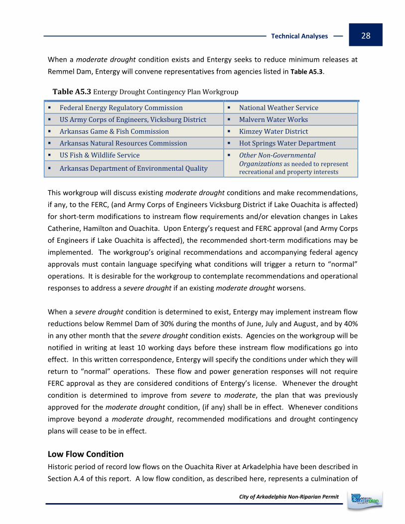
When a moderate drought condition exists and Entergy seeks to reduce minimum releases at
Remmel Dam, Entergy will convene representatives from agencies listed in Table A5.3.
Table A5.3 Entergy Drought Contingency Plan Workgroup
Federal Energy Regulatory Commission National Weather Service
US Army Corps of Engineers, Vicksburg District Malvern Water Works
Arkansas Game & Fish Commission Kimzey Water District
Arkansas Natural Resources Commission Hot Springs Water Department
US Fish & Wildlife Service Other Non-Governmental Organizations as needed to represent recreational and property interests Arkansas Department of Environmental Quality
This workgroup will discuss existing moderate drought conditions and make recommendations,
if any, to the FERC, (and Army Corps of Engineers Vicksburg District if Lake Ouachita is affected)
for short-term modifications to instream flow requirements and/or elevation changes in Lakes
Catherine, Hamilton and Ouachita. Upon Entergy’s request and FERC approval (and Army Corps
of Engineers if Lake Ouachita is affected), the recommended short-term modifications may be
implemented. The workgroup’s original recommendations and accompanying federal agency
approvals must contain language specifying what conditions will trigger a return to “normal”
operations. It is desirable for the workgroup to contemplate recommendations and operational
responses to address a severe drought if an existing moderate drought worsens.
When a severe drought condition is determined to exist, Entergy may implement instream flow
reductions below Remmel Dam of 30% during the months of June, July and August, and by 40%
in any other month that the severe drought condition exists. Agencies on the workgroup will be
notified in writing at least 10 working days before these instream flow modifications go into
effect. In this written correspondence, Entergy will specify the conditions under which they will
return to “normal” operations. These flow and power generation responses will not require
FERC approval as they are considered conditions of Entergy’s license. Whenever the drought
condition is determined to improve from severe to moderate, the plan that was previously
approved for the moderate drought condition, (if any) shall be in effect. Whenever conditions
improve beyond a moderate drought, recommended modifications and drought contingency
plans will cease to be in effect.
Low Flow Condition
Historic period of record low flows on the Ouachita River at Arkadelphia have been described in
Section A.4 of this report. A low flow condition, as described here, represents a culmination of

City of Arkadelphia Non-Riparian Permit
Technical Analyses 29
circumstances which cause significant and sustained below-average flows on the Ouachita River
or its tributaries to the extent that ANRC would contemplate a declaration of . During shortage
a , watershed-level allocation would be implemented according to Title 3 Rules for the shortage
Utilization of Surface Water. Non-riparians would experience withdrawal restrictions before
riparians during allocation if a was declared. Verification of individual non-riparian net shortage
consumptive uses and a subbasin assessment would preface any restrictive action imposed by
ANRC during a declared . shortage
The Project Monitoring Action Plan (PMAP) describes conditions that must exist at multiple
locations before restrictions are considered by ANRC (PMAP is contained in the Executive Summary
section of this report). Figure A5.3 diagrams the primary factors which will influence surface
water availability in the upper Ouachita River subbasins. If deterioration of these factors
prevails, the cumulative impact could result in the implementation of drought management
planning and possible restriction. A defined low flow condition which requires restriction on
surface water withdrawals has not been quantified because: 1) there are no concentrated
clusters of registered diverters on the Ouachita River to restrict, and 2) there is not one factor
that can be measured which solely represents overall subbasin conditions. The low flow
condition, as defined by ANRC, represents a sustained, physical , as evidenced by shortage
concurrent deterioration of factors in Figure A5.3 and forecasted circumstances which cannot be
overcome through normal, routine efforts.
Figure A5.3 Factors Affecting Low Flow on Ouachita River

City of Arkadelphia Non-Riparian Permit
Technical Analyses 30
-Blakely Dam-
-Remmel Dam-
-DeGray Lake Dam-
City of Arkadelphia
-Project Diversion-
-Carpenter Dam-
Figure A5.4 Diagram of Ouachita River Basin Regulation
Thatcher Lock & Dam
Felsenthal Lock & Dam
The PMAP (see Executive Summary) describes the thresholds at specific locations which trigger
monitoring and management actions. The Figure A5.4 schematic shows locations of federal
projects on the Ouachita River between Lake Ouachita and the Arkansas-Louisiana state line.
As diagramed, upper Ouachita River subbasin runoff and subsequent flows downstream are
controlled largely by regulation and routing of Lake Ouachita storage. Given this situation, the
PMAP identifies multiple triggers (conditions) at multiple locations that must exist in order to
determine a . shortage

City of Arkadelphia Non-Riparian Permit
Technical Analyses 31
B. AGENCY COORDINATION Two meetings were held with state and federal agencies to discuss the proposed project and
potential environmental issues associated with water withdrawals from the Ouachita River.
One meeting was held at ANRC with state and federal agencies located in central Arkansas and
another meeting was held in Vicksburg MS between ANRC staff and Vicksburg District Corps of
Engineers Regulatory Division. ANRC received several comments and data regarding aquatic
species that may occur near the project intake and discharge structures on the Ouachita River.
This report will be circulated to those agencies and made public through the ANRC website.
ANRC will accept additional data or information generated from other agencies after the
provisional permit is issued. Any data received will be evaluated by ANRC to determine its
relevance to normal operation (water withdrawals) of the proposed project.
C. PERMIT CONSIDERATIONS Additional discussions of permit items are contained in the Executive Summary and other
sections of this report. This section includes some of those previously discussed items and
additional site-specific considerations.
C.1 Curtailment State water law grants authority to ANRC to allocate surface water during times of declared
shortages. During a shortage, surface water use is prioritized and allocated according to
ANRC’s Title 3 Rules for the Utilization of Surface Water. Surface water uses for sustaining
human health are reserved water rights and therefore exempt from allocation. Processes for
declaring a shortage and administrative procedures to implement allocation are contained in
ANRC’s Title 3 Rules for the Utilization of Surface Water. Specific discussion of curtailment and
potential limitation on project withdrawals are discussed in the Executive Summary,
Environmental Considerations, and Low Flow Condition sections of this report.
C.2 Length of Permit Recognition of non-riparian rights for intrabasin, interbasin, and interstate transfer of water in
Arkansas water law originated to allow diversion and transport of surface water to meet total
agricultural water needs in the delta region of the state and reduce groundwater demand and
depletion of the Mississippi alluvial aquifer. These projects were envisioned to transport large
volumes of surface water and require significant capital costs to construct, operate, and
maintain. However, many non-agricultural non-riparian water uses being permitted today vary

City of Arkadelphia Non-Riparian Permit
Technical Analyses 32
greatly in purpose and scale compared with the agricultural irrigation projects. One example of
a nonagricultural non-riparian permitted water use is for natural gas fracking.
The length of the non-riparian permit should reflect the need to periodically evaluate the water
use relative to permit conditions, current surface water availability, and any impacts to
environmental resources through normal operation of projects. Water use for natural gas
fracking is very dynamic, i.e. water transported from single withdrawal point to many “end-use”
locations and multiple projects simultaneously withdrawing water from small drainage basins-
makes it prudent to reevaluate more frequently permits issued for this water use sector when
compared to single, permanently located projects which are not likely to change withdrawal
quantities or water use locations.
Uncertainties related to surface water availability for this proposed project are relatively low.
The project will have a fairly constant withdrawal rate and the withdrawal location is not
expected to change (permanent) once the project becomes operational. For these reasons,
permit reevaluation and renewal is recommended to occur every 10 years.
C.3 Site-Specific Gaging The permittee or facility operator may be required to install a gaging apparatus on the Ouachita
River at the point of project diversion if deemed necessary by ARNC. The gaging apparatus will
be used to verify river conditions at the point of diversion and govern withdrawals during
allocation if implemented. Specifications for gaging capability will be determined after
environmental (federal) regulatory processes are complete and any additional data relevant to
normal operation of the project is identified.
C.3 Reporting Requirements The permittee or diversion facility operator is required to maintain a monitoring system capable
of reporting instantaneous and cumulative project withdrawals. Instantaneous reporting may
be required during evaluation of low flows and conditions. The Project Management shortage
Action Plan (PMAP) identifies conditions that could result in a . shortage
The permittee is responsible for reporting the project’s annual water use according to ANRC’s
water use registration procedures. Procedures for water use registration can be obtained from
ANRC’s Conservation Division.