CITY DEVELOPMENT PLAN Background Paper 2 Sustainable ...
20
CITY DEVELOPMENT PLAN Background Paper 2 Sustainable Spatial Strategy
Transcript of CITY DEVELOPMENT PLAN Background Paper 2 Sustainable ...

CITY DEVELOPMENT PLAN Background Paper 2
Sustainable Spatial Strategy

Background Paper 2 1
Background Paper 2 Sustainable Spatial Strategy 1.0 Introduction 1.1 This paper sets out the role of the Sustainable Spatial Strategy in supporting the delivery of the
City Development Plan – The Local development Plan (LDP) Strategic Outcomes and Vision. The Plan creates a spatial framework for Glasgow’s development over a ten year period up to 2024, and will be reviewed after five years. It is the Council’s aspiration, however, that the Plan will influence change in the shape and form of the City well beyond these timeframes, and will create the connected building blocks on which the City’s environment, economy and neighbourhoods can develop.
1.2 At the core of the Plan is a strong emphasis on placemaking, health and wellbeing, and
sustainability. These principles are critical to Glasgow’s strengths as a place; to the City’s ability to adapt to climate change; and to maximising the potential of its citizens. The Plan’s clear focus should help to ensure that the City is well-positioned to meet the challenges of a changing climate and economy, and to build a resilient physical and social environment which helps attract and retain investment.
2.0 Background 2.1 The defining of a spatial strategy for Glasgow has been a feature of planning documents for
over 60 years starting with the Clyde Valley Regional Plan in 1946. For nearly 40 years the spatial strategy has been set by the Strathclyde Structure plan and its successors the Glasgow and Clyde Valley Structure Plan and more recently the Glasgow and Clyde Valley Strategic Development Plan. Section 15 of the Planning etc. (Scotland) Act 2006 Act requires LDPs to contain a spatial strategy, this being a detailed statement of the planning authority’s policies and proposals as to the development and use of land. As Glasgow is one of the four City Regions covered by a Strategic Development Plan it has to interpret in a City context the vision statement contained within that plan.
3.0 National and International Planning Context European Commission 3.1 In its publication “Cities of tomorrow” the European Commission states that Cities are the key
to sustainable development. More than two thirds of the European population lives in urban areas. Cities are places where both problems emerge and solutions are found. They are fertile ground for science and technology, for culture and innovation, for individual and collective creativity, and for mitigating the impact of climate change. However, cities are also places where problems such as unemployment, segregation and poverty are concentrated. The document set down a vision of a European city that is: a place of advanced social progress with a high degree of social cohesion, socially-
balanced housing as well as social, health and 'education for all' services; a platform for democracy, cultural dialogue and diversity; a place of green, ecological or environmental regeneration; a place of attraction and an engine of economic growth.
UK Government 3.2 The Scottish Government supports the five guiding principles of sustainable development set
out in the UK shared framework for sustainable development. The five principles are: living within environmental limits, ensuring a strong, healthy and just society, achieving a sustainable economy, promoting good governance, and using sound science responsibly.

Background Paper 2 2
National Planning Framework 2 3.3 NPF2 reiterates the “importance of place” that the first National Planning Framework saw as
key to a modern knowledge economy. Businesses choose to locate where they can recruit well-educated, talented people and capital flows to places which have the sort of physical and social infrastructure which supports innovation. Well qualified, creative people are attracted to places which offer a variety of economic opportunities, a stimulating environment, amenities for a wide range of lifestyles and good connections to other high quality places. Successful places have strong, positive identities. They are cosmopolitan, well connected and diverse, offering opportunities for a wide range of creative interaction. The environmental quality, built heritage and cultural life of Scotland’s cities and towns are therefore strong economic assets and planning policies must place emphasis on supporting and enhancing them.
3.4 The National Planning Framework 2 (NPF2) sets out a spatial development strategy to 2030 for
Scotland. The key aims of the strategy are to:
contribute to a wealthier and fairer Scotland by supporting sustainable economic growth and improved competitiveness and connectivity;
promote a greener Scotland by contributing to the achievement of climate change targets and protecting and enhancing the quality of the natural and built environments;
help build safer, stronger and healthier communities, by promoting improved opportunities and a better quality of life; and
contribute to a smarter Scotland by supporting the development of the knowledge economy.
3.5 NPF2 identifies the River Corridor which incorporates Clyde Gateway, the City Centre and the
Clyde Waterfront as a national regeneration priority and identifies national developments, including the West of Scotland Strategic Rail Enhancements (WSSRE); a High-Speed Rail Link (HSR) to London; the Central Scotland Green Network; the Metropolitan Glasgow Strategic Drainage Scheme; and Commonwealth Games Facilities and Infrastructure. The WSSRE and HSR are longer term projects.
3.6 The main elements of the Government's spatial strategy for Scotland through to 2030 are to:
support strong, sustainable growth for the benefit of all parts of Scotland; promote development which helps to reduce Scotland’s carbon footprint and facilitates
adaptation to climate change; support the development of Scotland’s cities as key drivers of the economy; support sustainable growth in the rural economy; conserve and enhance Scotland’s distinctive natural and cultural heritage, and continue
to safeguard internationally protected sites, habitats and species; expand opportunities for communities and businesses by promoting environmental
quality and good connectivity; promote development which helps to improve health, regenerate communities and
enable disadvantaged communities to access opportunities; strengthen links with the rest of the world; promote more sustainable patterns of travel, transport and land use; realise the potential of Scotland’s renewable energy resources and facilitate the
generation of power and heat from all clean, low carbon sources; encourage a sufficient supply of homes which are affordable in places where people want
to live; and facilitate the implementation of the National Waste Management Plan including waste
management targets.

Background Paper 2 3
Scottish Planning Policy
3.7 The Scottish Government’s Scottish Planning Policy (SPP) states that the planning system has an important role in supporting the achievement of sustainable development through its influence on the location, layout and design of new development. More specifically, it requires decisions on the location of new development to promote regeneration and the re-use of previously developed land; reduce the need to travel and prioritise sustainable travel and transport opportunities; promote the development of mixed communities; take account of the capacity of existing infrastructure; and prevent further development which would be at risk from flooding.
Designing Places 3.8 Designing Places is a policy statement published by the Scottish Government in 2010. It states
that the planning system needs “Development plans with effective design policies, and urban design frameworks, development briefs and masterplans to provide planning and design guidance”.
3.9 Designing Places recommends that The Local Development Plan must set out the council’s
distinctive vision for how its area will develop. It should summarise its appraisals of the most important features of the area’s character and identity. The plan should also set out key design policies relating to issues that are particularly important locally, and to specific areas and sites where change is expected. It should explain how the planning process should deal with design, such as by specifying where urban design frameworks are needed and in what circumstances a development brief should be prepared.
3.10 The plan should specify what degree of detail will be expected in planning and design
guidance; in what degree of detail proposals should be presented at different stages in the planning application process; and in what circumstances planning application design statements will be needed, for example, in relation to particular types of development of more than a specified size. It should also specify which areas or sites need guidance with the status of supplementary planning guidance and how guidance should be prepared. An effective plan will set out concisely the local authority’s priorities in relation to design, leaving the detail to be provided in guidance documents.
4.0 Strategic context Glasgow and Clyde Valley Strategic Development Plan 4.1 The SDP sets out a shared spatial vision and strategy for the SDP area, which gives physical
expression to the Glasgow and the Clyde Valley Community Planning Partnership’s corporate vision. It promotes a compact city model which comprises five key components:
Economy – an emphasis on the City Centre and other key employment locations, well
served by sustainable transport both within the City and beyond. Urban fabric – the renewal of the urban fabric and excluded communities through: the
recycling of brownfield land: use of passive, carbon-neutral energy efficient building standards; agglomeration and density; and a network of centres as the focus for economic activity, social and community life.
Infrastructure – the promotion of sustainable transport and active travel networks and new and upgraded water and drainage infrastructure.
Environment – a focus on green infrastructure and open space, both formal and informal, providing green corridors, pathways, playing spaces, parks, trees and natural green spaces, helping improve the living environment, provide opportunities for healthy living and aid competitiveness.
Energy – the promotion of decentralised energy generation based on alternative technologies to exploit opportunities for combined heat and power.

Background Paper 2 4
4.2 The SDP use a number of core spatial components to reinforce the compact city model. This includes:
The Development Corridor Community Growth Areas Green Network Network of Strategic Centres Strategic Economic Investment Locations
These core spatial components are supported by the City Development Plan’s strategic outcomes and objectives and spatial vision.
5.0 Glasgow’s Sustainable Spatial Strategy Overview 5.1 A futures visioning exercise was carried out as part of the development work on the Glasgow
and Clyde Valley Strategic Development Plan. This helped to develop the shared spatial vision and strategy for the SDP area. The shared vision and strategy is the start point, along with the evidence from the monitoring statement and the outcome of the main issues report, for the creation of the sustainable spatial strategy for Glasgow.
Glasgow City Council Strategic Plan 2012 – 2017
5.2 The Council’s strategic plan was approved in spring 2013. There are five priority areas where the Council aims to drive real progress and achievement in Glasgow over the next five years. These are to make sure Glasgow has:
Economic growth; and is A world class city A sustainable city A city that looks after its vulnerable people A learning city.
The Local Development Plan will help to deliver on all of these outcomes. The aim is to align the spatial outcomes for the LDP with the Council’s Strategic Plan focus on growth and resilience for the city and our communities. The Council’s Strategic Plan also identifies the key medium term priorities for the development of the City as: improving the quality of life for everyone in the city, a city where there is fairness, diversity and equality for all, encouraging organisations and local people to work together in more radically different
ways to make this happen, promoting Glasgow as a world class city, competing for business, events and investment
globally, raising attainment in schools and providing training and skills opportunities for all in the
city, providing greater connectivity for businesses and local people through improved
transport, better roads, and better access to the internet and information technology, generating innovative investment in the city’s infrastructure; and, investing in potential business growth sectors such as green and low carbon industries.
Glasgow City Plan 2 – The Local Plan
5.3 The current adopted Glasgow City Plan 2’s development strategy focuses on promoting brownfield development. The Plan’s development strategy is underpinned by three guiding principles – promoting social renewal and equality of opportunity; delivering sustainable development; and improving the health of the City and its residents. City Plan 2 outlines four main topic headings being: people, jobs, infrastructure and environment. It also assesses the progress made in key regeneration areas throughout the City.

Background Paper 2 5
6.0 Glasgow City Development Plan - The Local development Plan Monitoring Statement 6.1 The monitoring statement prepared in support of Glasgow Main Issues Report analysed the
progress that had been made to date on the delivery of the strategic outcomes and objectives and spatial vision. A number of potential issues that required to be addressed by the local development plan were identified as follows:
Climate change and its impact is one of the key drivers of change for the Local
Development Plan. The significant reduction in property investment and development activity as a result of
the economic downturn. This will impact on all areas of development. The means of delivering infrastructure in the current economic climate. The excess of land supply for private sector housing and a potential additional
requirement for social rented/affordable housing. The need to mitigate against climate change whilst minimising environmental impact may
have implications for residential density. Increasing level of unemployment. The rationalisation of the City’s poorer quality industrial and business areas to achieve a
more sustainable land use pattern. Financial constraints are likely to impact on future public realm works. The capacity of the City’s surface water drainage system presents a constraint to
development, limiting the City’s development aspirations. The volume of vacant and derelict land in the City is not falling as quickly as anticipated in
City Plan 2. Planning for the delivery of a high speed rail link to Glasgow. The need to review transport route reservations for potential future transport
infrastructure. The cumulative impact of major retail development outwith the City Centre. Protect and improve local accessibility to shopping and other town centre uses in order to
promote sustainable communities and healthy living. The land use implications arising from the Scottish Government’s waste reduction and
recycling targets. The need to develop policy guidance in relation to sustainable construction methods. The economic downturn has meant that funding cuts have jeopardised or limited
progress of some education projects. The future use of surplus healthcare facilities. The provision of future culture and sport facilities in the current economic climate.
Main Issues Report
6.2 In light of the findings of the monitoring statement the preferred Spatial Strategy identified through the Main Issues Report (MIR) focuses on renewal and regeneration, but with an enhanced emphasis on sustainable development, health, climate change mitigation and adaptation and placemaking. As with City Plan 1 and 2, the focus of the strategy is on promoting brownfield development. The MIR identified 6 key themes to further develop:
1. Sustainable Use of Resources; 2. Sustainable, Strong Economy; 3. Sustainable, Strong Communities; 4. Sustainable Connections; 5. Sustainable Environment; and 6. Sustainable Design

Background Paper 2 6
The policy framework proposed at the MIR stage reflected the need for: an enhanced sense of place, delivered through protecting, enhancing and capitalising on
the best elements of the existing urban environment, whilst delivering new housing and other development;
a continuing focus on the development of brownfield land over Greenfield; continuing to direct major investment to the City Centre to reinforce it’s role as the core
of the city and wider region and to capitalise on it’s accessibility by public transport and other sustainable modes;
a network of other centres which provide a variety of uses and will provide a focus for economic and community life in their areas and for sustainable transport systems;
a portfolio of attractive business and industrial sites offering a high quality environment for new and existing businesses and jobs for residents and others;
promoting greater use of public transport and active travel; an urban fabric designed to enable more efficient use of resources; an enhanced Green Network; prioritisation in the current economic environment, choices will need to be made about
where greatest impact from public investment can be derived; and effective partnerships between the public, private and third sectors and communities, and across disciplines, are likely to be critically important in ensuring the long-term success of regeneration projects.
Considerations for the Emerging Plan
6.3 Following consultation on the Main Issues Report the consensus was to adapt and simplify the 6 themes into four overarching outcomes. This would all align with the Council’s Single Outcome Agreement. The Plan therefore recognises that there are significant issues which are common to all parts of the City. The Sustainable Spatial Strategy aims to address these issues through having a clear key message that the City is in transition with outside influences and trends impacting on how the City develops and grows over the 5 year period of the plan. The key themes and policy framework outlined in the MIR have been further developed with the identification of the four strategic outcomes that the delivery of the LDP’s spatial vision will achieve. These are:
a thriving and sustainable place to live and work ; a connected place to move around and do business in; a vibrant place with a growing economy; a green place
6.4 An overarching Placemaking Policy, together with 11 subject based policies, will set the
parameters for development management decisions that will promote a sustainable pattern of growth. This will take account of scale and type of development pressure and the need for growth and regeneration. In addition, the Spatial Strategy will provide the long term context for development across the city, guiding new development to the right places. The three national priority areas of the City Centre, Clyde Gateway and Clyde Waterfront will be highlighted together with the opportunities for development across the City at a Community level. The Strategy will allow for the co-ordination of key infrastructure investment including water, drainage, transport, education, energy and digital.
6.5 The strategy will be supported by spatial planning guidance that will form supplementary
guidance. This will take the form of Strategic Development Frameworks (SDF) and Local Development Frameworks (LDF). The SDF and LDF have been identified through a process of examining local areas and identifying what opportunities and challenges exist and where there would be most benefit from a co-ordinated intervention. The appendices outline the considerations which led to the areas being identified and also highlight opportunities that exist within each spatial location. As the life of The Plan continues there may be opportunities to identify new priority areas through the appropriate consultation approach. Further spatial

Background Paper 2 7
supplementary guidance shall come forward in the form of, development briefs, master plans, design guides and design statements.
7.0 References
European Commission, Cities of Tomorrow, 2011 Scottish Government, National Planning Framework for Scotland 2, 2009 Scottish Government, Scottish Planning Policy, 2010 Scottish Government, Designing Places, 2010 Glasgow and Clyde Valley Joint Structure Plan, 2006 Glasgow and Clyde Valley Strategic Development Plan Strategic Futures Group Visioning BR03 2011 Glasgow and Clyde Valley Strategic Development Plan 2012 Glasgow city Council, Strategic plan 2012 – 2017, 2012 Glasgow City Council, City Plan 2 Glasgow City Council, Monitoring Report, 2011 Glasgow City Council, Main Issues Report, 2011

Background Paper 2 8
APPENDIX 1 - Background Paper 2 Strategic Development Frameworks City Centre River Clyde Development Corridor Glasgow North Govan/Partick Easterhouse Inner East

City CentreStrategic Development Framework
Safeguarded Business AreasStrategic Economic Investment LocationsMajor Masterplanning AreasClyde GatewayGreatest Potential District Heating Zones
SOA “Thriving Places”Housing Change AreasClyde FastlinkGreen Network PrioritiesScottish Vacant and Derelict Land Survey 2012
National Strategic Significance
Glasgow City Centre is a key economic driver for the whole of Scotland (NPF2). Glasgow City Centre is Scotland’s primary metro-politan centre and the City-region’s economic core (SDP).
Need to set a strategic framework for implemen-tation of the spatial elements of Glasgow City Centre Strategy and Action Plan 2014-2019, which will, in turn, set design parameters for the preparation of Local Development Frameworks for the 9 City Centre districts.
DemographicsOpportunity to plan for projected growth in popu-lation within the City Centre.
Vacant and Derelict Land
Concentrated areas of derelict land in the eastern part of the City Centre which reduce permeability and connections to the East End.
InfrastructureOpportunity for climate mitigation and adaptation measures, including greening of streets.
Location for new High Speed Rail terminus.
Queen Street Station transport hub improve-ments.Opportunity to coordinate improvements to walking and cycling routes, including public realm works to key sites/streets.
Need to improve drainage capacity to unlock development sites.
One of a number of areas in the City with signifi-cant potential for district heating.
HousingNew housing and supporting services needed to cater for projected population growth within the City Centre.
Economic GrowthCity Centre, IFSD and City Science designated as Strategic Economic Investment Locations.
Major Masterplanning AreasUniversity and College campuses.
IFSD 2.
© Crown Copyright and database right 2013. All rights reserved. OS Licence No. 100023379.You are not permitted to copy, sub-license, distribute or sell any of this data to third parties in any form.
Green NetworkRiver Clyde & Clyde Walkway.
Greening streets.

River Clyde Development Corridor Strategic Development Framework
Safeguarded Business AreasStrategic Economic Investment LocationsMajor Masterplanning AreasClyde GatewayGreatest Potential District Heating ZonesScottish Vacant and Derelict Land Survey 2012
SOA “Thriving Places”Housing Change AreasClyde FastlinkMajor Road ProposalsGreen Network PrioritiesAthletes Village
National Strategic SignificanceThe River Clyde Corridor is a national regenera-tion priority, with the Clyde Gateway and Clyde Waterfront being the main focus in the medium term (NPF2). The River Clyde Development Corridor is a strategic priority, and Clyde Waterfront and Clyde Gateway are Flagship Initiatives (SDP).
Pacific Quay is one of four sites within the ‘Creative Clyde Enterprise Area’ designated by the Scottish Government.
Greater Gorbals, Greater Govan and Parkhead/ Dalmarnock are priority areas for the Single Outcome Agreement’s ‘Thriving Places’ programme.
DemographicsThere are likely to be major demographic changes as the character of the area changes.
Vacant and Derelict LandLarge areas of vacant and derelict land along the River Corridor, much of which suffers contami-nation issues.
Green NetworkYoker, Govan/Ibrox, Gorbals/Toryglen and Clyde Gateway are Glasgow and Clyde Valley Green Network spatial priorities.
Development of integrated green infrastructure underway at Clyde Gateway.
River Clyde and Clyde Walkway.
InfrastructureRiver Clyde (together with other watercourses) is a resource that can be utilised to improve surface water drainage in many parts of the City.
Potential to introduce water-based transport to improve links between the City Centre and water-front communities along the River Clyde.
Potential for new river crossing to improve accessibility between Govan and Partick.
Improvement works required to the quay walls along the River.
Clyde Walkway extension is identified as a Commonwealth Games Legacy project.
Implementation of the Metropolitan Glasgow Strategic Drainage Plan is crucial to the success-ful delivery of development projects within Clyde Gateway and will be complemented by strategic green network improvements.
HousingDelivery of Laurieston TRA to improve housing choice and quality.
Economic GrowthCreative Clyde Enterprise Area at Pacific Quay focusing on the continued development of a ‘creative industries hub’.
Strategic Economic Investment Locations at Pacific Quay, City Centre and Clyde Gateway.
Major Masterplanning AreasClyde Gateway, including the Commonwealth Games Legacy sites.
Clyde Waterfront, including Glasgow Harbour, SECC, Govan Graving Docks, Pacific Quay, Water Row.
River Clyde – consider all aspects of the water space, including access, transport, water-based uses, adjacent land uses, habitat, green network, marine heritage, flooding, quay walls etc.
© Crown Copyright and database right 2013. All rights reserved. OS Licence No. 100023379.You are not permitted to copy, sub-license, distribute or sell any of this data to third parties in any form.
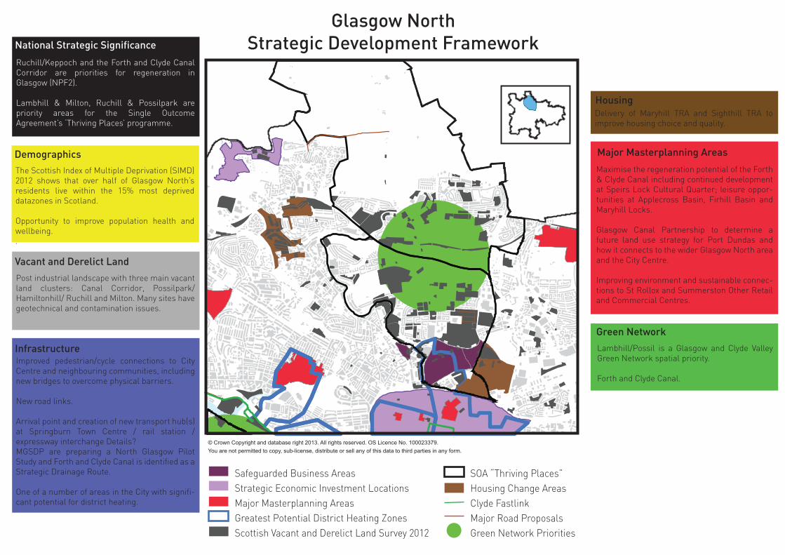
Glasgow NorthStrategic Development Framework
Safeguarded Business AreasStrategic Economic Investment LocationsMajor Masterplanning AreasGreatest Potential District Heating ZonesScottish Vacant and Derelict Land Survey 2012
SOA “Thriving Places”Housing Change AreasClyde FastlinkMajor Road ProposalsGreen Network Priorities
National Strategic Significance
Ruchill/Keppoch and the Forth and Clyde Canal Corridor are priorities for regeneration in Glasgow (NPF2).
Lambhill & Milton, Ruchill & Possilpark are priority areas for the Single Outcome Agreement’s ‘Thriving Places’ programme.
DemographicsThe Scottish Index of Multiple Deprivation (SIMD) 2012 shows that over half of Glasgow North’s residents live within the 15% most deprived datazones in Scotland.
Opportunity to improve population health and wellbeing..
Vacant and Derelict Land
Post industrial landscape with three main vacant land clusters: Canal Corridor, Possilpark/ Hamiltonhill/ Ruchill and Milton. Many sites have geotechnical and contamination issues.
InfrastructureImproved pedestrian/cycle connections to City Centre and neighbouring communities, including new bridges to overcome physical barriers.
New road links.
Arrival point and creation of new transport hub(s) at Springburn Town Centre / rail station / expressway interchange Details? MGSDP are preparing a North Glasgow Pilot Study and Forth and Clyde Canal is identified as a Strategic Drainage Route.
One of a number of areas in the City with signifi-cant potential for district heating.
HousingDelivery of Maryhill TRA and Sighthill TRA to improve housing choice and quality.
Major Masterplanning Areas
Maximise the regeneration potential of the Forth & Clyde Canal including continued development at Speirs Lock Cultural Quarter; leisure oppor-tunities at Applecross Basin, Firhill Basin and Maryhill Locks.
Glasgow Canal Partnership to determine a future land use strategy for Port Dundas and how it connects to the wider Glasgow North area and the City Centre.
Improving environment and sustainable connec-tions to St Rollox and Summerston Other Retail and Commercial Centres.
© Crown Copyright and database right 2013. All rights reserved. OS Licence No. 100023379.You are not permitted to copy, sub-license, distribute or sell any of this data to third parties in any form.
Green Network
Lambhill/Possil is a Glasgow and Clyde Valley Green Network spatial priority.
Forth and Clyde Canal.

Govan/PartickStrategic Development Framework
Safeguarded Business AreasStrategic Economic Investment LocationsMajor Masterplanning AreasGreatest Potential District Heating ZonesScottish Vacant and Derelict Land Survey 2012
SOA “Thriving Places”Housing Change AreasClyde FastlinkMajor Road ProposalsGreen Network Priorities
National Strategic SignificanceLies within the River Clyde Development Cor-ridor which is a national priority for regeneration in NPF2 and a strategic priority in the SDP. Pacific Quay is one of four sites within the ‘Crea-tive Clyde Enterprise Area’ designated by the Scottish Government.
Clyde Waterfront and Govan are priority areas for helping to deliver the Central Scotland Green Network in the Glasgow area (NPF2).
Greater Govan is a priority area for the Single Outcome Agreement’s ‘Thriving Places’ programme.
DemographicsDisparities in multiple deprivation levels (including health, wealth, employment and education) between Govan and Partick.
Opportunity to improve population health and wellbeing, particularly in Govan.
Vacant and Derelict Land
Large areas of vacant and derelict land concen-trated along banks of River Clyde, much of which suffers geotechnical and contamination issues.
InfrastructurePotential for a new pedestrian bridge across the River Clyde to improve connections between Govan and Partick.
Potential for a new pedestrian bridge across the Clydeside Expressway to improve connections between Yorkhill and the River.
Clyde Fastlink
North Clydeside Development Route.
One of a number of areas in the City with signifi-cant potential for district heating.
HousingDelivery of East Govan and Ibrox Transforma-tional Regeneration Area to improve housing quality and choice. Ongoing delivery of Glasgow Harbour.
Economic GrowthCreative Clyde Enterprise Area at Pacific Quay focusing on the continued development of a ‘creative industries hub’.
Strategic Economic Investment Location at Pacific Quay highlighted as an opportunity for creative and digital industries / tourism in the SDP.
Major Masterplanning AreasSouth Glasgow Hospital and surrounding area.
Glasgow Harbour.
Site incorporating Yorkhill Sick Childrens Hospi-tal and former Queen Mothers Maternity Hospi-tal.
Glasgow University Campus Development Framework.
Central Govan Action Plan and Govan Townscape Heritage Initiative.
Opportunity to improve connections between major visitor attractions via the Clyde and Kelvin Rivers.
© Crown Copyright and database right 2013. All rights reserved. OS Licence No. 100023379.You are not permitted to copy, sub-license, distribute or sell any of this data to third parties in any form.
Green Network
Govan/Ibrox is a Glasgow and the Clyde Valley Green Network spatial priority.
Clyde Walkway.
River Kelvin Corridor.

EasterhouseStrategic Development Framework
Safeguarded Business AreasStrategic Economic Investment LocationsMajor Masterplanning AreasGreatest Potential District Heating ZonesScottish Vacant and Derelict Land Survey 2012
SOA “Thriving Places”Housing Change AreasMajor Road ProposalsGreen Network Priorities
National Strategic SignificanceGarthamlock is a priority area for regeneration in Glasgow (NPF2).
The Central Scotland Green Network is a national development and Easterhouse has a critical role to play in its delivery (NPF2).
Easterhouse is a priority area for the Single Outcome Agreement’s ‘Thriving Places’ programme.
DemographicsA significant proportion of the population live in areas of high multiple deprivation.
Opportunity to improve population health and wellbeing.
Vacant and Derelict Land
Large areas of vacant & derelict land, many with geotechnical and contamination issues.
InfrastructureOpportunity to improve public transport coverage and connections between communities, town centres and to employment destinations.
HousingCommunity Growth Areas identified at Easterhouse/Gartloch and Robroyston/Millerston.
Economic GrowthEasterhouse Major Town Centre - has a role to play in the context of community growth.
Major Masterplanning AreasBetter integration between Glasgow Fort and the rest of Easterhouse Town Centre through delivery of a Town Centre Action Plan.
© Crown Copyright and database right 2013. All rights reserved. OS Licence No. 100023379.You are not permitted to copy, sub-license, distribute or sell any of this data to third parties in any form.
Green Network
Greater Easterhouse is a Glasgow and the Clyde Valley Green Network spatial priority.
Delivery of 7 Lochs Wetland Park Masterplan.

Inner EastStrategic Development Framework
Safeguarded Business AreasStrategic Economic Investment LocationsMajor Masterplanning AreasClyde GatewayGreatest Potential District Heating ZonesScottish Vacant and Derelict Land Survey 2012
SOA “Thriving Places”Housing Change AreasMajor Road ProposalsGreen Network PrioritiesAthletes Village
National Strategic Significance
The East End of the City is an ongoing national priority for regeneration (NPF2)
Central Scotland Green Network is a national development and Dalmarnock has a critical role to play in its delivery (NPF2).
Parkhead / Dalmarnock is a priority area for the Single Outcome Agreement’s ‘Thriving Places’ programme.
DemographicsA significant proportion of the population live in areas of high multiple deprivation with many areas in the 15 % most deprived data zones in Scotland, including the number 1 most deprived data zone in the country.
Health is generally worse than both the national average and the level for all of Glasgow. In particular, those with ‘Bad Health’ is more than double the proportion for Scotland.
Vacant and Derelict LandLarge areas of vacant & derelict land, many with geotechnical and contamination issues, which serve to disconnect the East End from the rest of the City, particularly the City Centre.
InfrastructureHigh Street Station upgrade.
Phase 3 of the East End Regeneration Route and re-alignment of Duke Street at Todd Street/Carntyne Road.
Public realm improvements at key sites.
One of a number of areas in the City with signifi-cant potential for district heating.
HousingDelivery of Gallowgate TRA to improve housing choice and quality.
Major Masterplanning AreasOngoing delivery of Clyde Gateway.
2014 Commonwealth Games legacy opportuni-ties.
© Crown Copyright and database right 2013. All rights reserved. OS Licence No. 100023379.You are not permitted to copy, sub-license, distribute or sell any of this data to third parties in any form.
Green Network
Gorbals/Toryglen is a Glasgow and Clyde Valley Green Network spatial priority.
Glasgow Green.

APPENDIX 2 Local Development Frameworks A number of Local Development Frameworks are proposed across the City to deliver planning change at a local level where it is recognised that an additional layer of planning intervention is required. It is recognised that while these areas do not face the same scale of challenge or degree of change as those areas identified as strategic priorities in the Plan, these areas still face important challenges and also offer significant opportunities to justify more detailed consideration and action focused intervention to be delivered through the proposed Local Development Frameworks. Overarching principles applicable to all of the Local Development Frameworks are similar in many ways to those for the Strategic Development Frameworks, but on a reduced scale. These principles are: To create an overall framework within which individual planning applications could be assessed, To develop a Framework for the City district which provides a strong context for making funding
bids for regeneration and directing development activity. To provide an overview of the social, spatial and economic geography of the area as a whole and
to develop an understanding of the distinct character areas within the study. To provide basis for partnership working with relevant agencies, groups and the public. In this
regard the concept of planning as primarily a social / democratic activity would be important. To make planning central to regeneration activity in the area, to try to ensure that all the activity
ongoing and in the future contributes to the development of a cohesive whole. Along with addressing the above matters the three Local Development Frameworks that have been identified shall seek to address the area specific issues identified in the profiles below. LDF Area Profiles Drumchapel In 2005 the Council commenced the New Neighbourhood initiative in Drumchapel. This involved a land deal with New City Vision in order to build 1500 private homes throughout the vacant land in the area. However, to date less than 100 units have been delivered on only part of the first of 8 sites. In 2002, Drumchapel Town Centre was acquired by the Premier Property Group and in 2005 a Masterplan to redevelop the town centre was produced for the centre owners and the Council. The Masterplan was intended to deliver a 5 year programme of works providing rationalised and sustainable retail, a civic hub and new build private housing. The Masterplan stalled due to a lack of economic viability. Evidently, there is market failure affecting the town centre, the new neighbourhood and this has also affected Dalsetter business village. The business village has stalled since development of Phase 1 and Phase 2a, the Commands and Garscadden House buildings respectively. The site remains serviced awaiting Class 4 industrial and Class 5 Business users. Drumchapel Business Village, 132,000 square feet, on an 8.2 acre site at Garscadden Road and Dalsetter Avenue was expected to create 600 jobs. it is now proper to review both of the previous adopted plans to consider their 5-10 year cycle and to ensure those proposals for Drumchapel which are not yet implemented, in part or whole, become integrated and endorsed for the next 5-10 year cycle for planning the land use strategy (via the Local Development Plan). A review will address what has and has not changed and importantly what change must now occur to facilitate regeneration of the area. City Plan 1 set out ‘to target planning action to stimulate and sustain regeneration activity involves a commitment to prepare, in consultation with local interests, Local Development Strategies that will deliver detailed planning solutions to mobilise the public and private sector’ The objective remains to ‘(i) remove constraints to develop and create opportunities for

new investment; and (ii) facilitate the regeneration of the area in order that it may become a competitive and sustainable urban area.’ By re-affirming Drumchapel as a spatial priority, a Local Development Framework will be produced focussing on; Population retention; Housing choice; Shortage of employment opportunities; Management and maintenance of green space; Safe and attractive living environment; Improved accessibility; and Town Centre renewal. Essential to the revision of the Local Development Strategy is a review of the New Neighbourhood, the Town Centre Masterplan, the Dalsetter Business Village and their respective development agreements. City Plan 2 noted ‘considerable progress has been made’ in the Drumchapel Area of Focus, stating; ‘That is not to say that regeneration activity… is complete, only that a less comprehensive planning approach to physical regeneration is now required.’ Against this background, council has approved key policy documents which did not exist at the time of project initiation for the new neighbourhood, town centre and business village. Key National and European policy, directives and statute may now also apply together with existing and emerging best practice which requires consideration in relation to these projects. The Local Development Plan will bring forward a Local Development Framework and it is expected that all relevant council development agreements will be reviewed accordingly to achieve the sustainable development and regeneration of the new neighbourhood, town centre and the business village. The green space network will also require a review and consideration given to update management plans and local open space strategy. South Central The area of South Central Glasgow comprises a number of communities on the periphery of the City Centre including Govanhill, Toryglen and Shawlands. As an area, it includes neighbourhoods with very different characteristics which face a series of challenges, both physical and social, but also includes successful, vibrant urban areas which offer significant opportunities to contribute positively to urban life in the City. Govanhill is a traditional Glasgow tenemental neighbourhood, well connected to the City Centre by public transport and good access to important local amenities, including two town centres (Victoria Road and Govanhill), a City Park (Queen’s Park) and other community facilities such as schools, churches and community centres. However in recent years, Govanhill has faced significant challenges due in part to a significant influx of immigrants from Eastern Europe. Although many of the challenges that this has presented are social in nature, it has also manifested itself in the physical fabric of Govanhill, both in terms of housing conditions and the public realm and streetscape. Planning therefore has a role to play in the multi-agency approach to regeneration in Govanhill which can be addressed through the proposed Local Development Framework. Toryglen faces different challenges, with significant areas of vacant land resulting from housing clearance evident, resulting in a fractured physical environment. The housing led regeneration of Toryglen is to be delivered through the Transformational Regeneration Area programme in partnership with Glasgow Housing Association, however in order to re-connect Toryglen to the City, it is considered appropriate to include this area within the wider Local Development Framework.

Shawlands is a vibrant urban neighbourhood focused around the Tier 2 town centre, the key retail and commercial centre in the south central part of the city. A Town Centre Action Plan was approved in 2010 to protect and enhance the role of Shawlands Town Centre as the commercial heart of this area. In addition a new Conservation area has been designated at Shawlands Cross, recognising the quality and heritage value of the built environment in this area. There is an opportunity for the proposed Local Development Framework to build upon these initiatives and to put in place a policy framework to ensure that the benefits of the current investment in Shawlands are maximised for the wider community. There is also a requirement to focus on the connections between this area and the City Centre in particular. There has been significant regeneration activity in recent years in the Gorbals/Laurieston area and Oatlands to the north of the proposed Framework area, however there are significant areas of vacant and derelict land which creates a physical barrier between these communities. It is recognised that the scale of the challenge faced will require a co-ordinated approach to guide planning and investment decisions. The key challenges to be addressed in the proposed Local Development Framework: Dislocation caused by Vacant & Derelict Land Geotechnical and contamination constraints Infrastructure constraints (transport, drainage capacity etc) Poor environmental conditions within some housing and industrial areas Connections to the wider City, and in particular the City Centre Sustaining a vibrant network of Town Centres, particularly the tier 2 Centre at Shawlands and the
Tier 3 Centre at Victoria Road and Govanhill. Repair and reconnection of residential neighbourhoods Improved population health and well being Access to employment Increased housing choice Other opportunities and challenges will be identified in the detailed analysis stage of the preparation of the proposed Framework. Pollok Greater Pollok is a large disparate area including distinct neighbourhoods and character areas such as Pollok, Nitshill and Arden, Pollok Town Centre, including Silverburn and also significant areas of green space, including Pollok Park and a significant area of green belt. There are also significant development opportunities such as the former National Savings and Investment site at Cowglen. A Local Development Framework is proposed to bring these separate areas together within a well planned and cohesive planning strategy. In areas such as Nitshill and Arden the focus is on housing led regeneration and which has stalled in recent years, leaving significant areas of vacant and derelict land and a break down in the urban fabric in parts of these communities. In recent years development frameworks for these areas have been prepared, however there is now a requirement to revisit these strategies in light of changing circumstances, particularly with regard to the housing market. There are also aspirations to expand the retail and commercial offer at Silverburn and a clear policy framework is required to manage this growth, particularly in terms of both traffic management and the impact on existing retail centres. The proposed Local Development Framework will establish this the criteria against which future proposals will be assessed, in addition to the other relevant policies in the Development Plan. The Framework will also establish the planning framework and design guidance against which proposals for the redevelopment of key sites such as Cowglen, including the site of the former National Savings and Investment building and the former Cowglen Hospital, can be assessed.

The Greater Pollok area boasts significant areas of green space and environmental assets. In addition to Pollok Park, there is the Stirling Maxwell Forest Park, Darnley Mill Country Park, the White Cart Water and a well established green network. The proposed Framework will seek to strengthen this network of green spaces and ensure that new development supports this ambition by ensuring access to the network is maintained and enhanced where required. It is recognised that the scale of the challenge faced will require a co-ordinated approach to guide planning and investment decisions. The key challenges to be addressed in the proposed Local Development Framework: Vacant & Derelict Land Geotechnical and contamination constraints Infrastructure constraints (transport, drainage capacity etc) Poor environmental conditions within some housing and industrial areas Delivery of the wider Green Network aspirations and protection of key environmental assets. Integrating Silverburn with the existing Town Centre through delivery of a Town Centre Action
Plan Repair and reconnection of residential neighbourhoods and management of stalled housing sites Improved population health and well being Access to employment Increased housing choice Other opportunities and challenges will be identified in the detailed analysis stage of the preparation of the proposed Framework.