City Council Special Meeting - Sammamish · Youth Board Meeting 19 9 a.m. ... Passed by the City...
120
City Council meetings are wheelchair accessible. American Sign Language (ASL) interpretation is available upon request. Please phone (425) 295-0500 at least 48 hours in advance. Assisted Listening Devices are also available upon request. AGENDA December 10, 2013 6:30 pm Call to Order Roll Call Pledge of Allegiance Approval of Agenda Public Comment This is an opportunity for the public to address the Council. Three-minutes limit per person or 5 minutes if representing the official position of a recognized community organization. Presentations Councilmembers Recognition Consent Agenda Payroll for the period ending November 30, 2013 for pay date December 5, 2013 in the amount of $ 271,848.89 1. Resolution: Final Plat Lawson Park 2. Contract: Bridge Load Rating Public Hearings - None Unfinished Business 3. Resolution: Related To Topics For Consideration In The 2015 Comprehensive Plan Rewrite Also Known As “Sammamish 2035” New Business 4. Discussion: Tree Retention Council Reports City Council Special Meeting
Transcript of City Council Special Meeting - Sammamish · Youth Board Meeting 19 9 a.m. ... Passed by the City...

City Council meetings are wheelchair accessible. American Sign Language (ASL) interpretation
is available upon request. Please phone (425) 295-0500 at least 48 hours in advance.
Assisted Listening Devices are also available upon request.
AGENDA December 10, 2013 6:30 pm 6:30 pm – 9:30 pm Council Chambers Call to Order Roll Call Pledge of Allegiance Approval of Agenda Public Comment This is an opportunity for the public to address the Council. Three-minutes limit per person or 5 minutes if representing the official position of a recognized community organization. Presentations
Councilmembers Recognition
Consent Agenda Payroll for the period ending November 30, 2013 for pay date December 5, 2013 in the
amount of $ 271,848.89 1. Resolution: Final Plat Lawson Park 2. Contract: Bridge Load Rating
Public Hearings - None Unfinished Business
3. Resolution: Related To Topics For Consideration In The 2015 Comprehensive Plan Rewrite Also Known As “Sammamish 2035”
New Business
4. Discussion: Tree Retention
Council Reports
City Council Special Meeting

City Council meetings are wheelchair accessible. American Sign Language (ASL) interpretation
is available upon request. Please phone (425) 295-0500 at least 48 hours in advance.
Assisted Listening Devices are also available upon request.
City Manager Report
Update: Council Chamber AV
Executive Session – If necessary Adjournment

Last printed 12/6/13
H:\COUNCIL\agenda topics.doc
AGENDA CALENDAR Dec 2013
Mon 12/9 Boards & Commission Appreciation Event
Tues 12/10 6:30 pm Special Meeting/Study
Session
Presentation: Councilmember Recognition Discussion: Tree Retention Ordinance Resolution: Final Plat Lawson Park Contract: Bridge Load Rating Update: Council Chamber AV
Mon. 12/16 6:30 pm Regular Meeting CANCELLED
Jan 2014
Tue 01/07 6:30 pm Regular Meeting Oath of Office New Councilmembers Elections: Mayor and Deputy Mayor Council Committees Contract: Sports Turf Maintenance Commission Interviews
Tues 01/14 6:30 pm Study Session Commission Applicant Interviews
Mon 01/20 MLK Day City Offices Closed
Tues 01/21 6:30 pm Special Meeting Public Hearing: Temporary Use Permit Extension Commission Appointments
February 2014
Tues 02/04 6:30 pm Regular Meeting Interlocal: ECityGov Alliance & Articles of Incorporation
Tues 02/11 6:30 pm Study Session Television Cable Franchise
Mon 02/17 President’s Day City Offices Closed
Tues 02/18 6:30 pm Special Meeting
Feb 22‐22 Council Retreat
March 2014
Tues 03/04 6:30 pm Regular Meeting
Tues 03/11 6:30 pm Study Session Comprehensive Plan Visioning
Mon 03/17 6:30 pm Regular Meeting
To Be Scheduled To Be Scheduled Parked Items Ordinance: Second Reading Puget Sound Energy Franchise Sammamish Landing Parking Big Rock Park Master Plan EF & R Interlocal
SE 14th Street Improvements


If you are looking for facility rentals, please click here.
<< November December 2013 January >>
Sunday Monday Tuesday Wednesday Thursday Friday Saturday
1 236:30 p.m.City Council Meeting
46:30 p.m.Parks and Recreation Commission MeetingCanceled
56:30 p.m.Planning Commission Meeting
66 p.m.Very Merry Sammamish
7
8
95:30 p.m.City Council Office Hour6 p.m.Boards and Commission Appreciation Event
106:30 p.m.Special Meeting / Study Session
11 12 13 14
15
166:30 p.m.City Council MeetingCanceled6:30 p.m.Arts Commission MeetingCanceled
17
186 p.m.Sammamish Youth Board Meeting
199 a.m.Donate Blood at City Hall6:30 p.m.Planning Commission Meeting
20 21
22 23 2425ChristmasCity offices closed
26 27 28
29 30 31 City offices closed
Page 1 of 1Printer Friendly Calendar
12/6/2013https://www.sammamish.us/events/Default.aspx?Month=12&Year=2013

If you are looking for facility rentals, please click here.
<< December January 2014 February >>
Sunday Monday Tuesday Wednesday Thursday Friday Saturday
112 a.m.New Years DayCity offices closed
2 3 4
5 676:30 p.m.City Council Meeting
86:30 p.m.Parks and Recreation Commission Meeting
94 p.m.Eagle Scout Project Meeting6:30 p.m.Planning Commission Meeting
10 11
12 13146:30 p.m.City Council Study Session
156 p.m.Sammamish Youth Board Meeting
16 17 18
1920Martin Luther King, Jr. BirthdayCity offices closed
216:30 p.m.City Council Special Meeting
22
236:30 p.m.Planning Commission Meeting
24251 p.m."Life Stories"
26276:30 p.m.Arts Commission Meeting
28 29 30 31
Page 1 of 1Printer Friendly Calendar
12/6/2013https://www.sammamish.us/events/Default.aspx?Month=1&Year=2014

City Council Agenda Bill Meeting Date: December 10, 2013 Date Submitted: December 4, 2013 Originating Department: Community Development Clearances:
City Manager Community Development Parks & Recreation Attorney Finance & IT Police Admin Services Fire Public Works
Subject: Resolution: Final Plat for Lawson Park Subdivision of 31 lots Action Required: Adopt resolution approving the subdivision Exhibits: 1. Proposed Resolution
2. Hearing Examiner Decision April 1, 2013. 3. Compliance matrix showing plat conditions and responses 4. Final Plat 5. Site Map and Vicinity Map.
Budget: $0
Summary Statement Description: The proposed Lawson Park subdivision to create 31 lots was reviewed and granted preliminary plat approval (after reconsideration) by the City of Sammamish Hearing Examiner on April 1, 2013. The Hearing Examiner approved the subdivision with conditions; the proposed final plat of 31 lots is consistent with the Hearing Examiner conditions and the applicable code.
Background
The subdivision application is vested to the City of Sammamish Municipal Code in effect on May 7, 2012. The City of Sammamish Hearing Examiner approved the preliminary plat on April 1, 2013, subject to conditions of approval. The City of Sammamish has reviewed, and approved the installation of the required infrastructure (drainage facilities, streets, sidewalks, etc.) improvements under plat construction and clear and grade permit BLD2012-01100. The improvements have been substantially completed and inspected. The final lift of asphalt, drainage improvements, and landscaping has been bonded for (see below). The area of the site being subdivided is zoned Residential, 4 units per acre (R-4). Access to the development on the site is via SE 14th Street and interior cul-de-sacs.
Page 1 of 2
Bill#1

City Council Agenda Bill Performance Bond: The applicant has posted a bond for the installation of the remaining site improvements (including streets and other required drainage improvements) in the amount of $ 160,798.46 under BLD2012-01100 on November 15, 2013. Landscaping Bond: The applicant has posted a street landscaping performance bond and a landscaping performance bond in the amount of $ 215,729.60 under BLD2012-01100 on November 19, 2013. Critical Areas: The plat has a wetland critical areas tract, Tract E. Street Mitigation Fees: The applicant has paid 100 percent of the street mitigation impact fee in the amount of $430,764.84, which was paid on November 19, 2013. No additional fees are due. School Mitigation Fees paid to the City of Sammamish: The applicant has paid fifty percent of the applicable Issaquah School District impact fees in the amount of $54, 201.00 on November 19, 2013, in addition to the current administration fee. The balance of the school impact fees shall be paid at the time of building permit issuance on a per lot basis. Park Impact Fees: Park Impact fees will be paid at the time of single family building permit issuance. The applicant has demonstrated to the City of Sammamish that all of the preliminary plat approval conditions have either been met, or have been bonded for and will be met in a timely manner.
Financial Impact: $0
Recommended Motion: Approve the 31-lot Lawson Park subdivision, and authorize the Mayor to sign the mylars for the final plat.
Page 2 of 2
Bill#1

CITY OF SAMMAMISH WASHINGTON
Resolution No. R2013-___ _______________________________________________________________________________
A RESOLUTION OF THE CITY OF SAMMAMISH, WASHINGTON, GRANTING FINAL PLAT APPROVAL TO THE PLAT OF LAWSON PARK PLN2012-00020 AND FSUB2013-00168
WHEREAS, the City Council has received recommendation of approval for the final plat
of the Lawson Park Subdivision; and WHEREAS, the City Council has reviewed said plat and finds that it conforms to all
terms of the preliminary plat approval and applicable land use laws and regulations; and WHEREAS, the City Council desires to grant final approval to the (31-lot) plat of the
Lawson Park subdivision PLN2012-00020 and FSUB2013-00168; NOW, THEREFORE, THE CITY COUNCIL OF THE CITY OF SAMMAMISH,
WASHINGTON, DO RESOLVE AS FOLLOWS: Section 1. Adoption of Hearing Examiner’s Findings and Conclusions.
The City Council hereby adopts the findings and conclusions included in the City of Sammamish Hearing Examiner’s decision of April 1, 2013 for the preliminary plat of Lawson Park.
Section 2. Grant of Approval. The City Council hereby grants final approval to the
Lawson Park final plat.
PASSED BY THE CITY COUNCIL AT A SPECIAL MEETING THEREOF ON THE _____DAY OF DECEMBER 2013.
CITY OF SAMMAMISH
________________________ Mayor Thomas T. Odell
1
Exhibit 1

ATTEST/AUTHENTICATED: _________________________ Melonie Anderson, City Clerk Approved as to form: _________________________ Michael Kenyon, City Attorney Filed with the City Clerk: December 5, 2013 Passed by the City Council: Resolution No.:
2
Exhibit 1

p:\admin services\admin assistant to the city clerk\hearing examiner\lawson park - pln2012-00020 emily\pln2012-00020d- final decision.doc
BEFORE the HEARING EXAMINER for the CITY of SAMMAMISH
DECISION: REVISED AFTER RECONSIDERATION 1
FILE NUMBER: PLN2012-00020
APPLICANT: William Buchan Homes, Inc. 2630 116th Avenue NE Bellevue, WA 98004
TYPE OF CASE: Preliminary subdivision (Lawson Park)
STAFF RECOMMENDATION: Approve subject to conditions
EXAMINER DECISION: GRANT subject to conditions
DATE OF REVISED DECISION: April 1, 2013 2
INTRODUCTION 3
William Buchan Homes, Inc. (Buchan) seeks preliminary approval of Lawson Park, a 31 lot single-family residential subdivision of a 10.05 acre site, owned by Nancy McIntosh-Sison and David McIntosh (McIntosh) and Jeanette Aman (Aman), which is zoned R-4. 4 Buchan filed a Base Land Use Application on April 20, 2012. (Exhibit S-1 5) The Sammamish Department of Community Development (the Department) deemed the application to be complete when filed. (Exhibit S-2)
1 Sections, paragraphs, and text which have been revised, added, or deleted through the reconsideration process are
identified by footnote. 2 Text and date revised to reflect reconsideration. 3 Any statement in this section deemed to be either a Finding of Fact or a Conclusion of Law is hereby adopted as such. 4 Ownership of the McIntosh property updated after reconsideration based upon Exhibit S-79.1.
Exhibit 2

HEARING EXAMINER DECISION: REVISED AFTER RECONSIDERATION RE: PLN2012-00020 (Lawson Park) April 1, 2013 Page 2 of 42
p:\admin services\admin assistant to the city clerk\hearing examiner\lawson park - pln2012-00020 emily\pln2012-00020d- final decision.doc
The subject property is located at 24400/24403 SE 14th Street. The Sammamish Hearing Examiner (Examiner) viewed the subject property on January 28, 2013. The Examiner convened an open record hearing on January 28, 2013, which was continued to and concluded on January 31, 2013. The Department gave notice of the hearing as required by the Sammamish Municipal Code (SMC). (Exhibits S-7, S-32, and S-35) The Examiner asked the Department to provide answers to three questions and held the record open until 5:00 p.m. on February 4, 2013, to receive the written answers: When was the 2012 Highway Capacity manual (HCM) adopted? Are there any differences between the 2010 and the 2012 HCM in the calculation of Level of Service (LOS)? If so, do those differences affect the LOS calculations made for Lawson Park? The Department’s response has been entered as Exhibit S-65. Subsection 20.05.100(1) SMC requires that decisions on preliminary subdivision applications be issued within 120 net review days after the application is found to be complete. The open record hearing was convened on or about net review day 210. The SMC provides two potential remedies for an untimely decision: A time extension mutually agreed upon by the City and the applicant [SMC 20.05.100(2)] or a letter from the Department explaining why the deadline was not met [SMC 20.05.100(3)]. The Department provided an explanatory letter to Buchan. (Exhibit S-9, p. 1) The following exhibits were entered into the hearing record during the hearing:
Exhibits S-1 – S-35: As enumerated on the Exhibit list provided at the start of the hearing Exhibit S-36: Beaverdam Division 1, Sheet 5 of 11 of the recorded plat Exhibit S-37: E-mail, Saylor to Arteche, January 23, 2013 Exhibit S-38: E-mail, Hartley to Arteche et al., January 28, 2013 Exhibit S-39: E-mail, McDorman to Arteche et al., January 28, 2013 Exhibit S-40: Sarao hearing statement Exhibit S-41: Saylor hearing statement Exhibit S-42: Barooah hearing statement Exhibit S-43: Photographs (4) of Noonchester property Exhibit S-44: Lider drainage review report, January 24, 2013 Exhibit S-45: Aramburu hearing statement, January 24, 2013 Exhibit S-46: Photograph of SE 14th Street submitted by Melancon Exhibit S-47: E-mail, Brown to Curry, January 28, 2013 Exhibit S-48: E-mail, Osbekoff to Arteche, January 29, 2013 Exhibit S-49: E-mails from petition signers (apprx. 49 signators) Exhibit S-50: Deed of Easement, May 25, 1959
5 Exhibit citations are provided for the reader’s benefit and indicate: 1) The source of a quote or specific fact; and/or 2)
The major document(s) upon which a stated fact is based. While the Examiner considers all relevant documents in the record, typically only major documents are cited. The Examiner’s Decision is based upon all documents in the record.
Exhibit 2

HEARING EXAMINER DECISION: REVISED AFTER RECONSIDERATION RE: PLN2012-00020 (Lawson Park) April 1, 2013 Page 3 of 42
p:\admin services\admin assistant to the city clerk\hearing examiner\lawson park - pln2012-00020 emily\pln2012-00020d- final decision.doc
Exhibit S-51: Aerial of Sammamish Exhibit S-52: Theodore J. Schepper Resume Exhibit S-53: Terra Associates, Inc. rebuttal testimony Exhibit S-54: Ryan Kahlo Resume Exhibit S-55: The Watershed Company response to public comments Exhibit S-56: Todd Oberg Resume Exhibit S-57: The Blueline Group response to public comments Exhibit S-58: E-mail, Geglia to Nelson, January 29, 2013 Exhibit S-59: Lawson Park Traffic Impact Analysis, April 10, 2012 Exhibit S-60: Buchan’s suggested condition regarding any discovery of Native American
artifacts Exhibit S-61: Photographs (6) of SE 14th Street Exhibit S-62: Location of well and water line to Noonchester property Exhibit S-63: Aramburu hearing statement, January 31, 2013 Exhibit S-64: Koloušková closing argument, January 31, 2013 Exhibit S-65: E-mail, February 4, 2013 (Department response to examiner questions)
RECONSIDERATION 6 On February 8, 2013, the Examiner issued a Decision (the “Initial Decision”) approving the preliminary subdivision subject to conditions. (Exhibit S-66 7) Four parties filed timely Requests/Motions for Reconsideration of the Initial Decision (the Requests):
A. Buchan sought reconsideration of Finding of Fact 4, Conclusions of Law 30 and 31, and Condition 4
to revise provisions relating to the Noonchester well. (Exhibit S-67) B. Howard and Cynthia Noonchester (the Noonchesters or Noonchester) sought reconsideration of
Finding of Fact 11.B (raised only in Footnote 1), Conclusion of Law 19, and Condition 19 and a determination that the proposal does not make appropriate provisions for stormwater runoff directed toward the Noonchester property. (Exhibit S-68)
C. Renaissance Ridge Homeowners Association (RRHOA) sought reconsideration of Conclusions of
Law 27 and 35 and reversal of the Decision because evidence does not prove that the gas pipeline through Renaissance Ridge will not be harmed by Lawson Park construction traffic. 8 (Exhibit S-69)
6 Section (excluding the final paragraph) added after reconsideration. 7 All documents generated during the reconsideration process after the hearing closed have been assigned exhibit numbers
to facilitate ease of citation and record-keeping.
Exhibit 2

HEARING EXAMINER DECISION: REVISED AFTER RECONSIDERATION RE: PLN2012-00020 (Lawson Park) April 1, 2013 Page 4 of 42
p:\admin services\admin assistant to the city clerk\hearing examiner\lawson park - pln2012-00020 emily\pln2012-00020d- final decision.doc
D. Ben Sarao (Sarao) sought reconsideration of unspecified portions of the Decision relating to site
grading adjacent to his property and reversal of the Decision because the final drainage plan may differ from the preliminary drainage plan. 9 (Exhibit S-70)
On February 25, 2013, the Examiner issued an Order Accepting the Requests and inviting parties of record to submit written comment by March 11, 2013. (Exhibit S-71) By E-mail on March 7, 2013, Buchan requested an extension of the comment period regarding the Noonchesters’ and its Requests to March 29, 2013. Buchan stated that it and the Noonchesters were diligently working to resolve their issues and that “the parties feel a positive resolution is likely but will require City staff input and potentially a proposal of revised conditions to the Examiner. As a result, both Buchan and the Noonchesters request that the Examiner stay the deadline for comments on reconsideration until Friday, March 29th.” (Exhibit S-72) On March 8, 2013, the Examiner amended the Order to allow Buchan and the Noonchesters until March 29, 2013, to submit written comments in response to each other’s Request. (Exhibit S-73) The following comments were received during the reconsideration process:
Exhibit S-74: Saylor Reconsideration comment, filed by E-mail at 9:35 a.m., retransmitted at 10:18 a.m. on March 11, 2013
Exhibit S-75: Sarao Reconsideration comment (with three attachments: S-75.1, S-75.2, & S-75.3), filed by E-mail at 11:05 a.m. on March 11, 2013 10
8 Buchan objects to the RRHOA Request on the grounds that RRHOA is not a party of record. (Exhibit S-78) While many
Renaissance Ridge residents testified during the hearing, the RRHOA is not an official party of record. RRHOA arguably lacks standing to seek reconsideration. That notwithstanding, the Examiner will address the RRHOA challenge in the text of this Decision.
9 The Sarao Request also contends that the Lawson Park application was not complete on May 7, 2012, as stated by the Department. If a determination of completeness is even an appealable action (the Examiner need not reach a conclusion on that question), the time period for filing an appeal would have expired 21 days after the determination was made. [SMC 20.10.080(1)] Thus, a challenge now is manifestly untimely and will not be considered.
The Sarao Request also contains an implied challenge to the State Environmental Policy Act (SEPA) threshold
Determination of Nonsignificance (DNS). The period within which to challenge the adequacy of the DNS ended on December 10, 2012. (Exhibit S-6) Any challenge to the adequacy of the DNS is manifestly untimely and will not be considered.
10 The Sarao comment E-mail contains additional argument on the subject matter within his Request (Exhibit S-70) and raises a wholly new issue: Sarao asserts that the preliminary plat fails to provide appropriate buffering for a wetland off-site to the south. It does not address the issues raised in any of the other Requests. (Exhibit S-75) Therefore, it is not a comment letter so much as an elaboration and expansion of Sarao’s own Request. Buchan has objected to expansion of reconsideration issues by Sarao. (Exhibit S-78) Elaborating on one’s own Request is a misuse of the comment process and introducing a new issue is simply impermissible: One cannot raise new issues after the close of the reconsideration period.
The Examiner will address both Sarao’s original issue and, notwithstanding its inappropriateness, his new issue in the
text of this Decision.
Exhibit 2

HEARING EXAMINER DECISION: REVISED AFTER RECONSIDERATION RE: PLN2012-00020 (Lawson Park) April 1, 2013 Page 5 of 42
p:\admin services\admin assistant to the city clerk\hearing examiner\lawson park - pln2012-00020 emily\pln2012-00020d- final decision.doc
Exhibit S-76: Department Reconsideration comment (with copies of the three Sarao attachments), filed by E-mail at 3:32 p.m. on March 11, 2013
Exhibit S-77: City Attorney well and water line easement Reconsideration comments, filed by E-mail at 4:05 p.m. on March 11, 2013
Exhibit S-78: Buchan comments on RRHOA and Sarao Reconsideration Requests, filed by E-mail at 4:11 p.m. on March 11, 2013
Exhibit S-79: Buchan’s Request for Modification of Decision, filed by E-mail at 3:41 p.m. on March 29, 2013
Exhibit S-79.1: Attachment to S-79: Settlement Agreement by and between the Noonchesters, McIntosh, Aman, and Buchan, executed in counterpart on March 29, 2013, with nine attachments: Six exhibits, an executed Water Line Easement and Water Use Release, an executed Drainage Easement, and an executed Temporary Construction Easement
The action taken herein and the requirements, limitations and/or conditions imposed by this decision are, to the best of the Examiner’s knowledge or belief, only such as are lawful and within the authority of the Examiner to take pursuant to applicable law and policy.
ISSUES
Does the application meet the criteria for preliminary subdivision approval as established within the SMC?
FINDINGS OF FACT 1. 11 The Lawson Park site is a rectangular assemblage of three tax parcels whose overall dimensions are
approximately 330 feet (east-west) by 1,320 feet (north-south) which encompasses 10.05 acres. The north half of the site consists of Tax Parcels 0224069079 and 0224069108, has a street address of 24400 SE 14th Street, contains a single-family residence and associated garage, and is owned by McIntosh. The south half of the site consists of Tax Parcel 0224069088, has a street address of 24403 SE 14th Street, contains a double-wide mobile home residence, and is owned by Aman. 12
11 Paragraphs 1 (Owner names updated, additional reference cited, and footnote added) and 2 (Footnote moved into the first
paragraph and revised) revised after reconsideration. 12 The application, Exhibit S-1, lists the owners of the subject property as “Mollie McIntosh/Jeanette Aman.” It is clear
from numerous exhibits and uncontroverted testimony that the north half of the subject property is owned by members of the McIntosh family. The Settlement Agreement submitted during the reconsideration process lists Jeanette Aman as the other property owner. (Exhibit S-79.1) The Examiner concludes that Jeanette Aman owns the south half of the subject property.
Exhibit 2

HEARING EXAMINER DECISION: REVISED AFTER RECONSIDERATION RE: PLN2012-00020 (Lawson Park) April 1, 2013 Page 6 of 42
p:\admin services\admin assistant to the city clerk\hearing examiner\lawson park - pln2012-00020 emily\pln2012-00020d- final decision.doc
(Exhibits S-1, S-3 13, S-4, S-9, and S-79.1) At the present time the subject property is accessed solely from the east via SE 14th Street.
For reference purposes throughout this Decision, the total site will be referred to as the “subject
property,” the north half will be referred to as the “McIntosh property,” and the south half will be referred to as the “Aman property.”
Buchan proposes to subdivide the 10.05 acres into 31 lots for single-family residences, two
stormwater control tracts, one open space tract, and one sensitive area tract. Buchan’s proposal will be described in greater detail in Finding of Fact 12, below.
2. The McIntosh and Aman properties are separated by SE 14th Street. SE 14th Street from the west
edge of the subject property easterly to 248th Avenue SE is, with but one exception which will be described below, a private street located within a 60 foot wide easement. The easement was created in 1959 by the van den Bogaerts as a “non exclusive easement for pedestrian and vehicular traffic and public utilities for the benefit of abutting lands and adjoining land to the north”. (Exhibit S-50) The easement contains a clause that the owners of the property subject to the easement “agree to convey said property by deed to King County at such time as King County is willing to accept such road.” (Exhibit S-50) When the area became incorporated as Sammamish, Sammamish became the successor to King County with respect to rights under the van den Bogaert easement.
The van den Bogaert easement is shaped like a cross and is between 30 and 60 feet in width. The
north-south leg of the easement is about 0.75 miles long and is now 248th Avenue SE, a City street. The east-west leg is about 0.5 miles long, is on the SE 14th Street alignment, and is centered on 248th Avenue SE. (Exhibit S-50)
The 0.25 miles of SE 14th Street from the west edge of the subject property to 248th Avenue SE,
except for the approximately 500 feet closest to 248th Avenue SE, currently exists as a dirt/gravel road whose driving surface is about 12 feet wide. It is gated at the west edge of the subject property to prevent through traffic. It is privately maintained by eight families. The north half of approximately the 500 feet of the easement nearest 248th Avenue SE has been dedicated/deeded to the City in conjunction with development of Windsor Fields. (See Finding of Fact 4, below.) A “half-street” improvement has been constructed on that portion of SE 14th Street. A “half-street” improvement consists of a sidewalk, planter strip, and curb on the development side of the right-of-way (the north side in this case) together with about 22 feet of paving. 14 (Exhibits S-39, S-46, and S-61 and testimony)
13 Many of the perimeter dimensions for the subject property as noted on the sheets of Exhibit S-3 are quite erroneous. For
example, Sheet 3 indicates that the north property line is only 67.89 feet long while the same sheet indicates that the south property line is 2,661.65 feet long. Neither dimension is even remotely close to being accurate.
14 A “half-street” improvement is typically employed where a development fronts on only one side of an unopened or substandard street. The concept is to have the developer complete full frontage improvements on its side of the right-of-
(Footnote continued on next page.)
Exhibit 2

HEARING EXAMINER DECISION: REVISED AFTER RECONSIDERATION RE: PLN2012-00020 (Lawson Park) April 1, 2013 Page 7 of 42
p:\admin services\admin assistant to the city clerk\hearing examiner\lawson park - pln2012-00020 emily\pln2012-00020d- final decision.doc
3. The subject property is bordered on the west by Renaissance Division 1 (north of SE 14th Street) and
Renaissance Division 2 (south of SE 14th Street). (These subdivisions are commonly known as Renaissance Ridge.) The Renaissance subdivisions were processed and approved under King County regulations prior to incorporation of Sammamish in 1999; they were recorded in 1988 and 1999. The Woodbridge Creek subdivision adjoins the south line of Renaissance Division 2; it had been recorded before Renaissance Division 1. (Exhibits S-26 and S-27)
A. Renaissance Division 1 Lots 166 (southern portion only) through 172 back up to essentially
the north half of the west edge of the McIntosh property. Those lots have widths (north-south dimension) between 49.61 feet (Lot 167) and 59.02 feet (Lot 172) and depths of approximately 110 feet. Tract T, to which Lots 173 – 178 back up, abuts the remainder of the west edge of the McIntosh property. Tract T is identified on the plat as “Open Space.” Tract T varies in depth (east-west measurement) from approximately 20 to 40 feet. Lots 173 – 178 vary in width from approximately 36 to 62 feet. (Exhibit S-26, Sheet 14)
Renaissance Division 1 Lots 166 – 172 are subject to a 20 foot wide (east-west
measurement) “TRE,” Tree Retention Easement. The TRE is to be maintained by the Renaissance homeowners association (HOA); use of the TRE is subject to a wildlife management plan recorded as part of the development’s covenants, conditions, and restrictions. (Exhibit S-26, Sheet 4, Note 17) Tract T is owned by the HOA and is to be used as open space. Tract T is purportedly subject to a “landscape easement” granted on July 31, 1997, to the then owners of the McIntosh and Aman properties. (Exhibit S-26, Sheet 4, Note 26) The current owners of the subject property have no knowledge of any landscape easement; their title reports do not disclose the existence of any such easement. (Testimony)
B. Renaissance Division 2 Tract U abuts the north 170 feet of the west edge of the Aman
property. Tract U is identified on the plat as “Open Space.” (Exhibit S-27, Sheet 5) Lots 82 through 84, 88, and 89 back up to the next 230 feet of the west edge of the Aman property. Those lots have widths (north-south dimension) between 45.00 feet (Lots 83, 84, and 89) and 54.39 feet (Lot 82) and depths of approximately 125 to 145 feet. Tract M encumbers the southeast corner of Renaissance Division 2. It is a sensitive areas tract which is intended to preserve a wetland which is mapped as extending onto the adjoining properties. (Exhibit S-27, Sheets 4 and 7)
Renaissance Division 2 Lots 82 through 84, 88, and 89 are subject to a 20 foot wide (east-
west measurement) TRE. That TRE is subject to the same restrictions as are associated with the TRE in Renaissance Division 1. (Exhibit S-27, Sheet 3, Note 16) Tract U, like Tract T in Renaissance Division 1, is owned by the HOA and is to be used as open space. It is also
way and provide a safe, two-lane travel surface, but leave completion of the remainder of the street (curb, gutter, planter strip, and sidewalk) to the future developer of the opposing side of the right-of-way. (Official notice)
Exhibit 2

HEARING EXAMINER DECISION: REVISED AFTER RECONSIDERATION RE: PLN2012-00020 (Lawson Park) April 1, 2013 Page 8 of 42
p:\admin services\admin assistant to the city clerk\hearing examiner\lawson park - pln2012-00020 emily\pln2012-00020d- final decision.doc
purportedly subject to the same “landscape easement.” (Exhibit S-27, Sheet 3, Note 23) The current owners of the subject property have no knowledge of any landscape easement; their title reports do not disclose the existence of any such easement. (Testimony)
C. The houses on the Renaissance lots listed above appear to have been built with code-
minimum, five foot side yards. (Exhibit S-13) D. One of the main north-south streets in Renaissance is 242nd Drive SE which extends
generally southerly from SE 8th Street, passes through a curve to the east, and terminates at the eastern boundary of Renaissance as SE 14th Street. The street segment from SE 8th Street to the east boundary of Renaissance will be referred to herein as 242nd Drive SE-SE 14th Street. None of the lots in Renaissance take direct access onto 242nd Drive SE-SE 14th Street. (Exhibit S-13 and testimony)
242nd Drive SE-SE 14th Street is blocked off by a chain link fence just east of its intersection
with SE 14th Way. The McIntoshes also have a fence across SE 14th Street on their side of the property line. (Testimony) There is, therefore, presently no through traffic on SE 14th Street.
E. 15 A 75 foot wide “GAS RIGHT-OF-WAY” passes from north to south through both
Renaissance subdivisions and the Woodbridge Creek subdivision. For approximately 800 feet within those subdivisions, the gas right-of-way parallels and abuts the west side of the 242nd Drive SE right-of-way. In the vicinity of Lawson Park, SE 8th Street, SE 11th Place, SE 14th Way, and SE 17th Place cross the gas right-of-way. Two of the three subdivisions created parks coterminous with the gas right-of-way: Tract D in Renaissance Division 1 and Tracts E and F in Renaissance Division 2. 16 (Exhibits S-13, S-26, and S-27)
One or two gas transmission pipelines, most probably a 30-inch pipe and a 26- or 36-inch
pipe, are buried within the gas right-of-way. 17 (Exhibit S-69, Attachment) In 2006 the pipeline operator, Williams Northwest, replaced “about 80 miles of pipe in Washington with wider pipe that can withstand greater pressure.” (Exhibit S-69, Attachment, p. 2, main article) In Sammamish, Williams Northwest replaced the 26-inch pipe with a 36-inch pipe beginning at NE 8th Street and running northward. (Exhibit S-69, Attachment, pp. 1 and 2
15 Finding revised after reconsideration. 16 Whether there is also a park coterminous with the gas pipeline right-of-way in Woodbridge Creek cannot be determined
from the record. 17 The article supplied by RRHOA with its Request (Exhibit S-69, Attachment) describes a pipeline replacement project
that occurred in 2006 in the area north of NE 8th Street. (“The 11.87-mile section that impacts Sammamish begins at Northeast Eighth Street and runs due north across state Route 202 ….” (Exhibit S-69, Attachment, p. 2) Nothing in the main article refers to the pipeline(s) near 242nd Drive SE. It is impossible to tell from the record whether that section of the gas right-of-way contains one or two gas transmission pipelines. (The sidebar article in the S-69 Attachment refers to a repair to the pipeline near SE 8th Street.)
Exhibit 2

HEARING EXAMINER DECISION: REVISED AFTER RECONSIDERATION RE: PLN2012-00020 (Lawson Park) April 1, 2013 Page 9 of 42
p:\admin services\admin assistant to the city clerk\hearing examiner\lawson park - pln2012-00020 emily\pln2012-00020d- final decision.doc
{sidebar article}) In-line inspection of the 30-inch pipeline in or around 2006 identified two “possible anomalies,” one of which was located near SE 8th Street, that “were caused by rocks located underneath the pipeline”. (Exhibit S-69, Attachment, p. 2, sidebar article) “Crews successfully removed the rocks and completed minor repairs.” (Ibid.)
F. No part of Renaissance Division 1 or Division 2 intrudes into or otherwise encumbers any
portion of the subject property. (Exhibits S-26 and S-27)
4. 18 The subject property is bordered on the east by several acreage tracts which take access from and maintain the private section of SE 14th Street. (Exhibit S-13) The abutting property owner to the McIntosh property is Noonchester. The Noonchester property encompasses about five acres divided into two tax account parcels. (Exhibit S-79.1, § 1.2) The Noonchesters reside on their property. (Testimony) 19
The northwest quadrant of the 248th Avenue SE/SE 14th Street intersection contains the Windsor
Fields subdivision, an approximate 20 lot single-family residential development. (Exhibit S-13 and testimony)
5. The subject property is bordered on the south by an acreage tract owned by the Louie family. The
Louies have recently built a single-family residence on their property approximately 35 feet south of the Aman property. (Exhibits S-13 and S-8 {pp. 38 – 40})
6. The subject property is bordered on the north by the Windham Court subdivision. Windham Court
was also developed under King County jurisdiction. All of five lots and most of a sixth lot in Windham Court back up to the north line of the McIntosh property. The five lots are approximately 57 feet wide (east-west dimension); the sixth is approximately 82 feet wide, but abuts the McIntosh property for only about 60 feet. Those six lots appear to be about 100 feet deep (north-south). (Exhibits S-3 {Sheet 3} and S-13 and testimony)
Immediately east of Windham Court and, thus, immediately north of the Noonchester property, is
Tract F, a large “Sensitive Area & Open Space” tract in Beaverdam Division 1. 20 Tract F extends
18 Finding revised after reconsideration. 19 On March 29, 2013, the Noonchesters executed a full release of any and all interest that they had in a “Water Line
Easement and Water Use Agreement” executed in 1977 by McIntosh family members. (Exhibit S-79.1, Release of All Interest in Water Line Easement and Water Use Agreement) The easement gave the Noonchesters (and others) access to a well on the McIntosh property for domestic water purposes and to a water line from the well to their property. (Exhibit S-8, pp. 2, 3, and 5) The well is located near the southeast corner of Proposed Tract D; the water line runs east from the well for about 40 feet and then doglegs to the south to run within the SE 14th Street easement to the Noonchesters’ property. (Exhibits S-3 {Sheet 3} and S-62 and testimony) Buchan has agreed to remove the water lines within the easement. (Exhibit S-79.1, § 2.1)
20 Windham Court was a further subdivision of Beaverdam Division 1 Tract R, a “Future Development” tract. (Exhibit S-36)
Exhibit 2

HEARING EXAMINER DECISION: REVISED AFTER RECONSIDERATION RE: PLN2012-00020 (Lawson Park) April 1, 2013 Page 10 of 42
p:\admin services\admin assistant to the city clerk\hearing examiner\lawson park - pln2012-00020 emily\pln2012-00020d- final decision.doc
north through the Beaverdam subdivision to SE 8th Street. Beaverdam was also developed under King County jurisdiction. 21 (Exhibits S-13 and S-36)
7. The Hazel Wolf Wetlands Preserve (mentioned in a number of the comment letters) is located about
one mile northeast of Lawson Park, accessible from Windsor Drive SE, bordered by a golf course on three sides. (Testimony)
Skyline High School (mentioned in comment letters and testimony) is located in the southeast
quadrant of the 228th Avenue SE/SE 8th Street intersection. (Testimony) Eastside Catholic High School (also mentioned in comment letters and testimony) is located a short
distance east of 228th Avenue SE, approximately one quarter mile north of SE 8th Street. (Testimony) All three of the above items are visible on Exhibit S-51 but are not specifically labeled. 8. The area’s zoning pattern was established by King County before Sammamish became an
incorporated city in 1999. In 2003 the City adopted its own comprehensive plan and implementing regulations under the Growth Management Act of 1990, Chapter 36.70A RCW (GMA). The City has left the zoning of the subject property unchanged through that process. (Official notice)
The subject property is designated on the City’s adopted comprehensive plan R-4 and zoned R-4,
residential development at a maximum density of four (4) dwelling units per acre, just as it was under the prior King County jurisdiction. Adjacent properties to the north, east, south, and southwest are also designated/zoned R-4; the 40± acre Renaissance subdivisions to the west and the Wesley Park area a short distance to the southeast along 248th Avenue SE are designated/zoned R-6 (residential with a maximum density of six (6) dwelling units per acre). (Exhibits S-11 and S-12)
9. The maximum permissible lot yield under the subject property’s R-4 zoning, calculated in
accordance with procedures spelled out in the SMC, is 32.7 dwelling units. (Exhibit S-20) Fractional results “of 0.50 or above shall be rounded up”, those “below 0.50 shall be rounded down.” [SMC 21A.25.070(4)] Therefore the maximum permissible lot yield is 33 dwelling units.
21 Although Exhibit S-36 does not include the dedications page of the recorded plat and thus does not include the recording
date, it contains three pieces of information that support this statement. First, it indicates that the development had a “D.D.E.S.” file number; “D.D.E.S.” is the acronym for a department within King County government. Second, the date of the engineer’s signature across his seal is either 1986 or 1996, both of which pre-date incorporation of the City. Third, the engineer’s seal states that his registration was to expire in 1997, thus meaning that he signed the plat prior to that date.
In addition, what eventually became Windham Court began life as Tract R in Beaverdam Division 1. (Exhibit S-36)
Sworn testimony stated that Windham Court had been developed under King County jurisdiction. In order for that to happen, Tract R also had to have been platted under King County jurisdiction.
Exhibit 2

HEARING EXAMINER DECISION: REVISED AFTER RECONSIDERATION RE: PLN2012-00020 (Lawson Park) April 1, 2013 Page 11 of 42
p:\admin services\admin assistant to the city clerk\hearing examiner\lawson park - pln2012-00020 emily\pln2012-00020d- final decision.doc
10. The subject property, although nearly level, does slope ever so gently both northeast and southwest from SE 14th Street. The elevation of both the southeast and southwest corners of the McIntosh property is 538 feet. The property is virtually level along its west side: The elevation of the northwest corner is approximately 537 feet. The two lowest elevations occur along the east property line: A small swale midway along the property line has an elevation of approximately 530 feet; the elevation along the property line then rises to approximately 535 feet before dropping to elevation 528 feet at the northeast corner, thus resulting in a drop across the north edge of the property from 537 feet to 528 feet. (Exhibit S-3, Sheet L1.0)
The Aman property drops about six feet along its east boundary from 536 to 530 feet. It drops 10
feet along its west boundary from 538 to 528 feet, matching the drop along the east side of the McIntosh property, thus resulting in a drop across the south edge of the property from 530 feet to 528 feet. (Exhibit S-3, Sheet L1.0)
11. Aquatic features on and off the subject property affect the proposed plat design.
A. Pond A and associated features. Pond A is a small, completely artificial pond dug in the north central area of the McIntosh property. Pond A is roughly 20 feet in diameter and located about 60 feet west of the McIntosh/Noonchester property line. Pond A receives runoff from French drains serving the McIntosh residence. During heavy rainfall events Pond A discharges onto the Noonchester property in a shallow, defined swale. Neither Pond A nor the discharge swale are regulated aquatic features under the City’s Environmentally Critical Areas regulations, Chapter 21A.50 SMC. (Exhibits S-3 {Sheet 3}, S-15, S-17 and testimony)
B. 22 Noonchester ponds. Drainage from Pond A feeds two somewhat larger, artificial ponds on
the Noonchester property. The Noonchester ponds were dug in or around the late 1970s. (The approximate location of one of the Noonchester ponds is shown on Exhibit S-3, Sheet 3. No field work was done to confirm the location or extent of that pond or any features associated with it.) Buchan’s wetland consultant and the City’s wetland specialist believe, based upon observations made from the McIntosh property and photographs of the area, that the Noonchester ponds may have been at least partly dug within what was previously a wetland area and, thus, may be regulated under Chapter 21A.50 SMC. The Noonchester ponds presumably drain north towards Tract F in Beaverdam. (Exhibits S-15, S-17, S-44 {especially Photos 1 and 2}, and S-76 and testimony)
C. 23 Beaverdam wetland. Tract F in Beaverdam contains a large Category II wetland. (Wetland D
in Exhibit S-15.) Its regulatory buffer does not encroach on the subject property. (Exhibits S-
22 Finding revised after reconsideration. 23 Finding revised after reconsideration.
Exhibit 2

HEARING EXAMINER DECISION: REVISED AFTER RECONSIDERATION RE: PLN2012-00020 (Lawson Park) April 1, 2013 Page 12 of 42
p:\admin services\admin assistant to the city clerk\hearing examiner\lawson park - pln2012-00020 emily\pln2012-00020d- final decision.doc
3 {Sheet 3} and S-15) The Department believes that the Beaverdam “wetland is likely connected to the wetland ponds on the Noonchester site”. (Exhibit S-76, unnumbered p. 2)
D. Renaissance Division 2 and Woodbridge Creek wetland. Tract M in Renaissance Division 2
and Tract A in Woodbridge Creek contain a Category II wetland which comes to within a few feet of the western edge of the Aman property. Discharges from that wetland flow westerly through a pipe system within Woodbridge Creek into the Woodbridge Creek detention pond in the southwest corner of that subdivision. (Exhibits S-3, S-15, S-17, and S-57)
E. The Louie property wetlands. Three Category III wetlands exist on the Louie property, south
of the Aman property: One in the northwest corner, one through the south central part of the property, and the third in the far southeast corner. (Exhibit S-18, September 19, 2008 Wetland Resources, Inc. report, beginning 9 pages after p. 3-14. (The intervening pages are not numbered; the report’s pages are numbered using a different pagination system.)) While both the northwest and central Louie wetlands may at one time have been part of the Renaissance Division 2 and Woodbridge Creek wetland, it appears that the central Louie wetland has since been separated and operates independently of the other. (Exhibits S-3, S-15, S-17, and S-57 24 and testimony)
12. 25 Buchan proposes to subdivide the subject property into 31 lots for single-family residential
development, two stormwater control tracts, one open space tract, and one sensitive area tract. All existing buildings on the subject property will be removed. (Exhibit S-3)
The SE 14th Street easement will be dedicated across the width of the property and a full width
standard local access street section will be built to the east edge of the property. (Exhibit S-3) Buchan takes no position on the question of whether SE 14th Street should be opened all the way to 248th Avenue SE. (Testimony)
The McIntosh property would be divided into 16 lots, the open space tract, and a stormwater control
tract. Tract D, the open space tract, would be located in the southwest corner of the McIntosh property and would include the well site. Buchan’s proposal, as reflected by its submittals, calls for elimination (officially “decommissioning”) of the well. Tract G, the stormwater control tract, would extend the full width of the north end of the property. (Exhibit S-3)
24 The consultant who authored Exhibit S-57 has his compass directions reversed in one part of the document. He initially
states that the Renaissance Division 2 and Woodbridge Creek wetland “has an overflow path to the east rather than the west.” (Exhibit S-57, unnumbered p. 2, Response to other Neighbors comments, ¶ 1) That statement is incorrect. The flow path description which follows that statement clearly describes a path that extends towards the west and south. Further, the revised Technical Information Report page 3-6 which follows in Exhibit S-57 correctly describes the flow as towards the west as do the attached South Basin Downstream Map and associated photographs.
25 Fourth paragraph in this Finding revised after reconsideration.
Exhibit 2

HEARING EXAMINER DECISION: REVISED AFTER RECONSIDERATION RE: PLN2012-00020 (Lawson Park) April 1, 2013 Page 13 of 42
p:\admin services\admin assistant to the city clerk\hearing examiner\lawson park - pln2012-00020 emily\pln2012-00020d- final decision.doc
The Aman property would be divided into 15 lots, the sensitive area tract, and the other stormwater
control tract. Tract E, the sensitive area tract, encumbers the southwest corner of the Aman property, providing a 75 foot buffer from the near edge of the Renaissance Division 2, Woodbridge Creek, and Louie wetlands. 26 Tract F, the stormwater control tract, extends across the remainder of the south end of the property. (Exhibit S-3)
The proposed average lot size is 8,332 square feet (SF); the smallest lot (Proposed Lot 7) would
contain 6,608 SF. For the most part, all proposed lots are 60 feet wide and slightly over 135 feet deep. All proposed lots are wider than adjoining lots in Renaissance. (Exhibit S-3) All proposed lots meet applicable zoning standards. (Exhibit 9)
13. 27 Buchan’s preliminary grading plan indicates that the subject property will be graded such that all
lots, except the seven southernmost lots, would be within a half-foot of elevation 538; the southernmost lots would drop down to elevations of about 534 feet. (Exhibit S-3, Sheet 3)
Pond A will be filled. (Exhibit S-3, Sheet 3) Buchan has received required permits from the U.S.
Army Corps of Engineers and the Department of Ecology to fill Pond A. (Exhibit S-55, p. 2) No fill is proposed along the west side of the McIntosh property: The proposed grades essentially
match existing grades. Proposed Lots 10 – 13 on the east half of the McIntosh property would have some fill placed on them. The preliminary grading plan indicates that a rockery ranging up to four (4) feet in height would be placed along the eastern edge of those lots to retain fill. (Exhibit S-3, Sheets 3 and L1.0)
26 Sarao asserts in his Reconsideration comment letter that the internal boundary of Tract E does not provide adequate
protection of the Louie wetland on the adjoining property to the south. In support of that assertion, Sarao quotes from an internal City E-mail which he says was “dated June 13, 2013 2:40PM”. The stated date is obviously incorrect: June, 2013, has not yet arrived. Given the text which he has placed in quotes, it is most likely that the E-mail dates from June 13, 2012. The purported City E-mail refers to a January 4, 2012, wetland study and states that the Tract E boundary “should be more extensive and include about 110-feet from the southwest property corner as well as whatever distance further north into Tract 9907 [sic} is needed to include the 75-ft buffer as extended from this off-site wetland feature.” (Exhibit S-75, p. 3)
The January 4, 2012, wetland study is an exhibit in the record. (Exhibit S-16) Exhibit S-16 does not mention or discuss
the Louie wetland. The Examiner did not make any reference to Exhibit S-16 in the Initial Decision as a newer, revised wetland report, prepared April 3, 2012, and further revised July 18, 2012, was also submitted. (Exhibit S-15) Exhibit S-15 specifically discusses the Louie wetland. (p. 3) The proposed preliminary plat which was considered by the Examiner was prepared on October 22, 2012, after issuance of Exhibit S-15. (Exhibit S-3) The internal Tract E boundary on Exhibit S-3 does, in fact, extend easterly 111 feet from the southwest property corner and does provide the required 75 foot buffer from the Louie wetland. (Exhibit S-3, Sheet 2 of 6) Sarao’s concern is based upon outdated and superseded information and, therefore, is without merit.
27 Footnote in last paragraph revised after reconsideration.
Exhibit 2

HEARING EXAMINER DECISION: REVISED AFTER RECONSIDERATION RE: PLN2012-00020 (Lawson Park) April 1, 2013 Page 14 of 42
p:\admin services\admin assistant to the city clerk\hearing examiner\lawson park - pln2012-00020 emily\pln2012-00020d- final decision.doc
No fill is proposed along the east side of the Aman property: The proposed grades essentially match existing grades. The preliminary grading plan indicates that up to four (4) feet of fill would be placed on Proposed Lot 26 along the western side of the Aman property. The preliminary grading plan indicates that the western edge of that fill would slope down towards the common boundary with Renaissance. (Exhibit S-3, Sheets 3 and L1.0) Buchan’s engineers are already working on the final engineering plans for the subdivision. In their present version, those plans indicate that a rockery up to four (4) feet in height would be placed along part of the west edge of Proposed Lot 26 to retain the fill. 28 (Exhibit S-10 and testimony)
14. Ten test pits, varying from seven (7) to 13 feet in depth, were dug scattered across the subject
property. Test Pits 1 and 2 are within the north stormwater detention pond; Test Pit 7 is within the south stormwater detention pond. (Exhibit S-28, Figure 2 29) Each of the test pits encountered slightly less than one (1) foot of forest duff on the surface, weathered till to a depth of between 1.5 to 4 feet below surface, with dense, consolidated till (“hardpan”) below the weathered till. Moderate groundwater seepage, evidence of “interflow” above the hardpan, was encountered between 1.5 to four (4) feet below surface. (Exhibit S-28 {Appendix A, Figures, A-2 – A-11} and testimony)
Test pits 1 and 2 encountered hardpan at 2.5 and 3 feet below surface, respectively, which would
equate to approximate elevations 534.5 and 529, respectively. Groundwater seepage was encountered in each test pit at 2 feet below surface, which would equate to approximate elevations 535 feet and 530 feet, respectively. (Test pit locations from Exhibit S-28, Figure 2; hardpan and groundwater seepage depths from Exhibit S-28, Appendix A, Figures A-2 and A-3; ground elevations from Exhibit S-3, Sheet L1.0)
Test pit 7 encountered hardpan at 3 feet below surface, which would equate to approximate elevation
529. Groundwater seepage was encountered at 2 feet below surface, which would equate to approximate elevation 530 feet. (Test pit location from Exhibit S-28, Figure 2; hardpan and groundwater seepage depth from Exhibit S-28, Appendix A, Figure A-8; ground elevation from Exhibit S-3, Sheet L1.0)
28 The existence of these final engineering working plans created some confusion during the hearing. Those plans are not of
record: This is a preliminary subdivision review, not a final subdivision review. However, some hearing participants had access to and used those plans in their testimony. Exhibit S-10 contains a fragment of one sheet of those plans (a fact which the Examiner did not realize until after the hearing). That is the only part of those plans that made it into the record before the Initial Decision was issued. Photographs of additional portions of those final engineering plans were submitted by Sarao during the reconsideration process. (Exhibit S-75, Attachments)
29 The Noonchesters’ counsel used a copy of Figure 2 from the February 9, 2012, version of the Geotechnical Report for demonstrative purposes in the hearing. That Figure had a reversed north arrow and depicted a different version of the proposed plat than that before the Examiner. The demonstrative figure was not entered into the record although the hearing participants commented on the erroneous north arrow. The Geotechnical Report was revised on July 17, 2012. Figure 2 in the revised report has its north arrow pointing in the correct direction and depicts the currently proposed plat design. (Exhibit S-28) The July 17, 2012, version of the report is the document in the record of this hearing, not the earlier version.
Exhibit 2

HEARING EXAMINER DECISION: REVISED AFTER RECONSIDERATION RE: PLN2012-00020 (Lawson Park) April 1, 2013 Page 15 of 42
p:\admin services\admin assistant to the city clerk\hearing examiner\lawson park - pln2012-00020 emily\pln2012-00020d- final decision.doc
15. The subject property lies within two drainage subbasins, the Inglewood drainage subbasin and Laughing Jacobs drainage subbasin. The McIntosh property lies within the Inglewood subbasin and is subject to Flood Area Flow Control (Level 3) and Sensitive Lake Water Quality Treatment. The Aman property lies within the Laughing Jacobs subbasin and is subject to Conservation Flow control (Level 2) and Sensitive Lake Water Quality Treatment. (Exhibits S-9 {pp. 3 and 4, Finding 16} and S-18 {p. 1-2})
16. The City has adopted the 2009 King County Surface Water Design Manual (2009 KCSWDM) as its
surface water design manual. [Chapter 13.20 SMC and Exhibit S-9] The 2009 KCSWDM is a public document which is available on-line at “http://your.kingcounty.gov/dnrp/library/water-and-land/stormwater/surface-water-design-manual/MainBody-2009.pdf”. (Official notice)
17. 30 Buchan has had a preliminary drainage plan prepared for Lawson Park. (Exhibit S-18 31) Basically,
the preliminary plan proposes to collect runoff, including that in foundation drains, in a pipe conveyance system, transport it to either of two detention ponds, one each at the north and south ends of the subject property, and then discharge the accumulated runoff through level spreaders. (Exhibits S-3 {Sheet 4} and S-18 and testimony)
The bottom of both detention ponds will be excavated into the hardpan, below the interflow level.
Design parameters in the 2009 KCSWDM consider and account for ground water. (Exhibit S-57) The maximum discharge rate from either pond has been designed to be less than 0.5 cfs (cubic feet
per second). Discharge from the north pond will be via a pipe to a level spreader on the northern edge of the Noonchester property where it will flow into the Beaverdam wetland. The Noonchesters have executed a drainage easement covering the area of their property where the pipe and level spreader will be located. 32 (Exhibits S-79 {§ II.A.ii} and S-79.1 {§ 2.4, Exhibit 6, and Drainage Easement}) Discharge from the south pond will leave the site as sheet flow into the buffer of the Renaissance Division 2 and Woodbridge Creek wetland. (Exhibits S-3 {Sheet 4} and S-18)
The preliminary drainage plan does not propose to replicate the present flows from Pond A onto the
Noonchester property. (Exhibits S-3 {Sheet 4} and S-18) The Department believes that discharge into the Beaverdam wetland as now proposed is an acceptable alternative to any discharge into the Noonchester ponds. (Exhibit S-76, unnumbered p. 2)
30 Finding revised after reconsideration. 31 The Noonchesters hired a licensed civil engineer (Lider) to review the preliminary drainage plan on their behalf. They
provided him with materials to review. It became clear during the hearing that Lider had not received a complete copy of Exhibit S-18.
32 This discharge system is different from that presented during the hearing. It is the result of negotiations between the Noonchesters and Buchan during the reconsideration period. However, it is important to understand that the discharge still flows in the same direction and towards the same destination (the Beaverdam wetland) as was proposed during the hearing.
Exhibit 2

HEARING EXAMINER DECISION: REVISED AFTER RECONSIDERATION RE: PLN2012-00020 (Lawson Park) April 1, 2013 Page 16 of 42
p:\admin services\admin assistant to the city clerk\hearing examiner\lawson park - pln2012-00020 emily\pln2012-00020d- final decision.doc
Runoff from much of the interior street surface would flow into 12 “rain gardens” (bioretention swales) located between the sidewalks and travel surfaces of the interior streets before being piped into the detention ponds. The rain gardens provide some water quality treatment of the street runoff. (Exhibit S-3, Sheet 4, and testimony)
18. “Streets and highways are most effectively classified by their function, according to the character of
the service they are intended to provide.” [Public Works Standards (PWS).15.050.A, ¶ 1] Section PWS.15.050.A lists a number of City arterials “to assist the developer in determining the classification of a particular street. … If a street or portion of a street is not listed, … the Public Works Department [shall] determine the correct street classification.” [PWS.15.050.A, ¶ 6]
SE 8th Street is a designated collector arterial. 33 (Exhibit S-58, PWS.15.050 excerpt) “Collector
arterials distribute trips from principal and minor arterials to the ultimate destination … Design year ADT [Average Daily Traffic] is approximately 2,500 to 15,000. …” [PWS.15.050.B.3; included in Exhibit S-58]
Neither 242nd Drive SE nor SE 14th Street are listed arterials. (Exhibit S-58, PWS.15.050 excerpt)
The Department of Public Works (DPW) classifies both as local access streets. 34 (Testimony) “Local feeder streets serve as primary access to the development from the adjacent street system. They distribute traffic from local or minor streets in residential neighborhoods and channel it to the arterial system. … Typical ADT may range from about 400 to 1,500. Abutting residences are oriented away from the feeder.” [PWS.15.050.B.4.a; included in Exhibit S-58]
19. Sight distance is calculated for a “design speed” which is typically 5 mph over the posted speed
limit. Two types of sight distance are used in traffic engineering: Entering sight distance and stopping sight distance. Entering sight distance is the distance required for a vehicle on the side street to safely enter the traffic flow on the major street. Stopping site distance is the distance required to safely stop when a low object is seen in the street ahead.
The City asked Buchan to calculate available sight distance at the 242nd Drive SE/SE 11th Place
intersection (presumably because the chain link barrier blocking 242nd Drive SE will be removed to allow access to Lawson Park from the west via SE 14th Street). The required entering sight distance for a 25 mph design speed is 355 feet. The available entering sight distance at that intersection will
33 Buchan’s traffic engineer offered corrections to his Traffic Impact Analysis (TIA). One such “correction” is to identify
SE 8th Street as a “minor arterial” rather than a “collector arterial.” (Exhibit S-58) In fact, PWS.15.050.A, included as part of Exhibit S-58, classifies SE 8th Street is a collector arterial, but NE 8th Street as a minor arterial. The engineer confused NE with SE 8th Street. The “correction” is unwarranted.
34 At least one City Councilperson believes “that 242nd Drive SE is intended to be a connecting arterial, without driveways”. (Exhibit S-8, p. 11 et al.) The City does not have a “connecting arterial” street classification. Buchan testified that 242nd Drive SE was designed under King County standards as a collector arterial. DPW testified that while 242nd Drive SE as built embodies features characteristic of an arterial (for example, no driveway curb cuts), the City does not currently classify it as an arterial.
Exhibit 2

HEARING EXAMINER DECISION: REVISED AFTER RECONSIDERATION RE: PLN2012-00020 (Lawson Park) April 1, 2013 Page 17 of 42
p:\admin services\admin assistant to the city clerk\hearing examiner\lawson park - pln2012-00020 emily\pln2012-00020d- final decision.doc
exceed 420 feet in both directions. The required stopping sight distance for a 25 mph design speed is 200 feet. Stopping sight distance exceeds 470 feet in both directions. (Exhibit S-25, p. 5)
20. Subsection 14.15.020(6) SMC requires that trip generation rates published by the Institute of
Transportation Engineers (ITE) be used in predicting traffic volumes associated with proposed developments. The ITE rates for single-family detached housing are 9.57 trips per house on an average weekday (AWDT), 0.75 trips per house during the average weekday A.M. peak hour, and 1.01 trips per house during the average weekday P.M. peak hour. 35 (Exhibit S-25, p. 3)
Given those rates, the trip generation prediction for Lawson Park is 297 AWDT, 23 A.M. peak hour,
and 31 P.M. peak hour (with credit for traffic associated with the two existing residences). (Exhibit S-25, p. 3)
21. The City has adopted a Transportation Concurrency Management system to implement the
transportation level of service policies within its comprehensive plan. [Chapter 14.15 SMC] Under Chapter 14.15 SMC, an applicant prepares and submits a transportation impact analysis (TIA) which is reviewed by (DPW). If the TIA demonstrates compliance with established levels of service (LOS), a concurrency certificate is issued. The City’s adopted LOS threshold is LOS D. (Exhibit S-65)
22. An initial TIA was prepared and submitted which presumed that SE 14th Street would not be opened
for traffic through to 248th Avenue SE. (Exhibit S-59) The City asked Buchan to have the TIA redone with calculations assuming that SE 14th Street would be opened for traffic. 36 (Exhibit S-25)
The ADT volume on 242nd Drive SE in 2012 is 810; the TIA projects that it will increase to 1,220 by
2014 with the project traffic, area growth, and opening of SE 14th Street. (Exhibit S-25, Fig. 13) Buchan’s consultant believes that opening SE 14th Street will add only about 80 ADT to 242nd Drive SE. (Testimony) The TIA concludes that resulting LOSs will be in the B and C range. (Exhibits S-25 and S-65)
35 The A.M. and P.M. peak hours are the single hour in the morning and afternoon, respectively, during which the highest
volumes of traffic are traveling on the local street system. (See SMC 14.05.010(20).) The “peak hour” does not represent the entire morning or afternoon “rush hour” unless the rush hour happens to last less than one hour. As everyone who lives in this region knows from personal experience, the morning and afternoon weekday rush hour each lasts much longer than one hour. Thus, the “peak hour” represents the single hour with the highest traffic volume within the entire “rush hour.” (Official notice)
The SMC mandates use of the ITE rates unless the applicant wants to try to prove that some other rate is more
appropriate. [SMC 14.15.020(6)] Staff has no authority to force a different rate on an applicant. 36 Some project opponents criticized the TIA because it used an out-dated version of the Highway Capacity Manual
(HCM). (Exhibit S-8, p. 22, et al.) The City’s LOS standards are based upon the 4th Edition of the HCM, issued in 2000. The 5th Edition HCM was issued in 2010. (One witness erroneously stated that it had been adopted in April, 2012, thus leading to the inaccurate year in the Examiner’s questions to the City. See Exhibit S-65.) The LOS standards and methods of calculating same are identical in both the 2000 and 2010 editions of the HCM. Both editions would yield identically the same results. (Exhibit S-65) Therefore, this objection lacks substantive import..
Exhibit 2

HEARING EXAMINER DECISION: REVISED AFTER RECONSIDERATION RE: PLN2012-00020 (Lawson Park) April 1, 2013 Page 18 of 42
p:\admin services\admin assistant to the city clerk\hearing examiner\lawson park - pln2012-00020 emily\pln2012-00020d- final decision.doc
23. On April 30, 2012, DPW issued a Certificate of Concurrency for Lawson Park. (Exhibit S-24) The developer will be required to pay transportation impact fees under Chapter 14.20 SMC. 37 As of
September 13, 2012, the fee was $14,853.96 per single-family residence. (Exhibit S-25, p. 6) 24. The subject property is generally wooded except where structures and drives have been built. The
McIntosh property is dominated by deciduous species, mostly big-leaf maple and red alder; the canopy is rather sparse. The McIntosh property appears to have been logged in or prior to the 1930s. The Aman property is dominated by evergreens, mostly red cedar plus Douglas fir, western hemlock, big-leaf maple, and red alder. (Exhibits S-13, S-14 {unnumbered p. 2}, and S-29 {p. 2})
25. The City has adopted tree retention requirements. [SMC 21A.35.210 - .240] New subdivisions must
retain at least 25% of all “significant” trees 38 located outside of protected sensitive areas [SMC 21A.35.210(2)(a)] and essentially all significant trees located within protected environmentally sensitive areas [SMC 21A.35.210(2)(b)] There is a proviso associated with the retention requirement: “trees retained within environmentally sensitive areas and associated buffers may be counted for up to 50 percent of the tree retention requirement in subsection (2)(a) of this section.” [SMC 21A.35.210(2)(b)] Further, up to 50% of the trees to be retained may be replaced by new trees upon approval by the Department; replacement ratios range from 4:1 to 8:1 depending upon the size of the tree to be replaced. [SMC 21A.35.210(6) and .240(1)(c)]
The regulations include criteria for selecting which trees to retain on a development site:
(a) Trees located within healthy, vegetated groups and stands rather than as isolated trees scattered throughout the site; (b) Trees that have a reasonable chance of survival once the site is developed; (c) Trees that will not pose a threat to persons or property; (d) Trees that can be incorporated into required landscaping or can be used to screen the site from adjacent properties; (e) Trees adjacent to open space, sensitive area buffers or sensitive area tracts; (f) Trees having a significant land stability function; or (g) Trees that meet the definition of heritage tree.
[SMC 21A.35.210(5)]
37 Such fees do not vest. Thus, a development is subject to fee changes that happen before the fee is paid. 38 The SMC defines a “significant tree” as either a coniferous tree with a diameter at breast height (DBH) of 8” or more or a
deciduous tree with a DBH of 12” or more. [SMC 21A.15.1333]
Exhibit 2

HEARING EXAMINER DECISION: REVISED AFTER RECONSIDERATION RE: PLN2012-00020 (Lawson Park) April 1, 2013 Page 19 of 42
p:\admin services\admin assistant to the city clerk\hearing examiner\lawson park - pln2012-00020 emily\pln2012-00020d- final decision.doc
26. The subject property contains 518 significant trees of which seven (7) are dead. 39 The number of live significant trees is 511, of which seven (7) are located within Proposed Tract E, the sensitive area tract. (Exhibit S-14) Pursuant to SMC 21A.35.210(2)(a), 126 (25% of 504) significant trees outside of sensitive areas and the seven (7) significant trees within the sensitive area tract must be retained. Pursuant to the proviso in SMC 21A.35.210(2)(b), the 7 trees within the sensitive area may count towards the 126 tree total.
Buchan proposes to retain 121 significant trees outside the environmentally sensitive area plus the 7
trees within Tract E, for a total of 128 significant trees retained. The retained trees: are in clusters along the rear lines of Proposed Lots 1 – 5, 13 – 16, 17 – 20, 22 – 26, 27 and 28, 30, and 31; are within open space Tract D; and are in two corners of drainage Tract G. (Exhibits S-3 {Sheet 3}and S-14)
In addition to the retained trees, Buchan proposes to landscape the area north and south of the two
stormwater detention ponds and plant 35 street trees. (Exhibit S-3, Sheet L1.0) 27. The record contains evidence that appropriate provisions have been made for:
A. Open space. Proposed Tract D will double as open space and recreation area. The tract covers 13,432 SF. The domestic water well is located within this tract. (Exhibit S-3 Sheets 1 and 3)
B. Drainage ways. See Findings of Fact 14 – 17, above. C. Streets and roads. DPW has reviewed and approved the proposed public and private streets
within Lawson Park. (Exhibit S-9) When the Staff Report was prepared on January 21, 2013, the City’s position regarding SE
14th Street was set forth in Finding 20:
A 500-ft long public road gap on SE 14th Street will exist after the dedication of roads within the proposed development project. A 60-ft wide easement for road purposes runs with the land that the City may in the future request to be dedicated as public right-of-way. The City may consider future paving and road dedication of SE 14th Street to eliminate the public road gap.
(Exhibit S-9, p. 4, Finding 20)
39 Buchan’s arborist accidentally surveyed 65 additional trees that were later determined to be located off the subject
property. This error occurred because the arborist did not have the benefit of a property line survey. (Exhibit S-14)
Exhibit 2

HEARING EXAMINER DECISION: REVISED AFTER RECONSIDERATION RE: PLN2012-00020 (Lawson Park) April 1, 2013 Page 20 of 42
p:\admin services\admin assistant to the city clerk\hearing examiner\lawson park - pln2012-00020 emily\pln2012-00020d- final decision.doc
On the first day of the hearing, the Department stated that all barriers on SE 14th Street would be removed after completion of Lawson Park allowing full through traffic between Renaissance and 248th Avenue SE. (Testimony)
On the second day of the hearing, DPW advised that the City intended to invoke the deed-
on-demand clause in the van den Bogaert easement (See Finding of Fact 2, above.) and would construct a 22 foot wide paved street section with a separated six (6) foot wide gravel path along its north side to connect SE 14th Street in Lawson Park to the existing half-street section in front of Windsor Fields. Although such a street section is not a standard City street section, it is essentially what presently exists on 248th Avenue SE south of SE 14th Street. (Testimony) In addition, 22 feet of pavement would equal the width required for the travel lanes on a two-lane collector arterial. [PWS.15.040, Table 1] The City wants Buchan “to consider” including a neighborhood traffic circle at the Road A/SE 14th Street intersection in the center of the plat. Under questioning from the Examiner, the City indicated that “to consider” means just what it says: Just think about providing a traffic circle. (Testimony)
D. Alleys. The proposed design does not utilize alleys. (Exhibit S-3) E. Other public ways. No need for other public ways within the subdivision exists. (Exhibit S-
3) F. Transit stops. The record contains no request for transit stops. G. Potable water supply. The Sammamish Plateau Water & Sewer District (SPWSD) issued a
Certificate of Water Availability for Lawson Park on April 17, 2012. Three days later the preliminary subdivision application was filed, thus fulfilling the Certificate’s requirement that an application be filed within one year of issuance of the Certificate. (Exhibit S-21) In addition, Buchan has now entered into a Developer Agreement with SPWSD for water service. (Exhibit S-9, p. 3, Finding 6)
H. Sanitary wastes. The Sammamish Plateau Water & Sewer District (SPWSD) issued a
Certificate of Sewer Availability for Lawson Park on April 17, 2012. Three days later the preliminary subdivision application was filed, thus fulfilling the Certificate’s requirement that an application be filed within one year of issuance of the Certificate. (Exhibit S-21) In addition, Buchan has now entered into a Developer Agreement with SPWSD for sewer service. (Exhibit S-9, p. 3, Finding 6)
I. Parks and recreation. The SMC requires that the subdivision include not less than 12,090 SF
of active recreation area within the subdivision. The proposal provides 13,432 SF in
Exhibit 2

HEARING EXAMINER DECISION: REVISED AFTER RECONSIDERATION RE: PLN2012-00020 (Lawson Park) April 1, 2013 Page 21 of 42
p:\admin services\admin assistant to the city clerk\hearing examiner\lawson park - pln2012-00020 emily\pln2012-00020d- final decision.doc
Proposed Tract D. (Exhibit S-3) In addition, the developer will have to pay a park impact fee pursuant to Chapter 14A.20 SMC. 40 (Exhibit S-9, p. 5, Finding 30)
In addition, Buchan proposes to install a children’s play feature in Tract D. (Exhibit S-3,
Sheet L1.0) As depicted, the placement of the play feature may conflict with the location of the existing domestic water well.
J. Playgrounds. See Finding 27.I, above. K. Schools and schoolgrounds. Lots within Lawson Park are subject to Chapter 21A.105 SMC
which imposes school impact fees on new single family dwelling units to fund school system improvements needed to serve new development. 41 (Exhibit S-9, p. 5, Finding 31)
L. Safe walking conditions for students who only walk to and from school. The subject property
is within the attendance areas for Discovery Elementary, Pine Lake Middle, and Skyline High Schools. Students attending all three of those schools will walk to a school bus stop at the 242nd Drive SE/SE 11th Place intersection in Renaissance. (Exhibit S-23)
Sidewalks will be constructed on all interior streets and will connect to the sidewalks along
242nd Drive SE-SE 14th Street in Renaissance. (Exhibit S-3) There are neither schools nor school bus stops to the east to which public school students would need to walk. (Exhibit S-23)
28. The adopted comprehensive plan contains many policies regarding environmental protection. The
City has adopted Chapter 21A.50 SMC, Environmentally Critical Areas, to implement many of those policies. Chapter 21A.50 SMC regulates treatment of erosion hazard areas, frequently flooded areas, landslide hazard areas, seismic hazard areas, critical aquifer recharge areas, wetlands, fish and wildlife habitat conservation areas, wildlife habitat corridors, streams, and lakes/ponds. [SMC 21A.50.220 - .355]
29. The wildlife habitat corridor provisions of SMC 21A.50.327 do not apply to the Lawson Park site.
Habitat corridor regulations apply “along the designated wildlife habitat network”. [SMC 21A.50.327] The subject property is not part of a designated wildlife corridor. (Exhibit S-31)
30. Sammamish’s State Environmental Policy Act (SEPA) Responsible Official issued a threshold
Determination of Nonsignificance (DNS) for Lawson Park on November 19, 2012. (Exhibit S-6) The DNS was not appealed. (Exhibit S-9, p.4, Finding 21)
40 Such fees do not vest. Thus, a development is subject to fee changes that happen before the fee is paid. 41 Such fees do not vest. Thus, a development is subject to fee changes that happen before the fee is paid.
Exhibit 2

HEARING EXAMINER DECISION: REVISED AFTER RECONSIDERATION RE: PLN2012-00020 (Lawson Park) April 1, 2013 Page 22 of 42
p:\admin services\admin assistant to the city clerk\hearing examiner\lawson park - pln2012-00020 emily\pln2012-00020d- final decision.doc
31. The Department has analyzed the Lawson Park proposal, finds it to be in compliance with applicable standards and requirements, and recommends approval subject to a number of conditions. (Exhibits S-9 and S-76)
32. Buchan agrees to accept the conditions as recommended by the Department. (Testimony) 33. There is significant opposition to Lawson Park. Opponents, generally speaking, fall into one or more
of four categories: Renaissance residents; residents along SE 14th Street east of Lawson Park; the Noonchesters; and Louie.
A. 42 Renaissance residents have expressed a variety of reasons to oppose Lawson Park. Some
believe that they were promised a wooded tract behind their homes when they bought and that the clearing involved in Lawson Park goes against that promise. Some decry the loss of wildlife habitat, especially as related to use of the site by pileated woodpeckers. Some believe that the houses that will be built in Lawson Park will be too big, closer together than their residences, and incompatible with their houses. Some believe that the additional traffic from Lawson Park will make their streets unsafe for children; some mention walkers traveling to the Hazel Wolf Wetland along SE 14th Street being in danger from motorists. Some believe that opening SE 14th Street through to 248th Avenue SE would greatly increase traffic through their neighborhood. They particularly argue that high school students living to the south and east would find the SE 14th Street corridor to be the shortest route to drive to both Skyline and Eastside Catholic High Schools. They believe that any opening of SE 14th Street should be coupled with installation of traffic calming devices along the corridor. Some question the safety of allowing construction truck traffic to travel 242nd Drive SE which parallels and abuts a gas transmission pipeline easement. 43 Some believe a perimeter greenbelt should be required and the number of dwellings reduced. Some distrust Buchan’s wetlands analysis because it was not performed by a City-hired consultant. Some simply object to construction noise (even if compliant with City construction hours regulations) in their neighborhood. (Exhibits S-8, S-38 – S-42, and S-47 and Sarao, Saylor, Barooah, and Voight testimony)
An on-line petition opposing approval of Lawson Park contained approximately 50
signatures as of the close of the hearing. (Exhibits S-37 and S-49)
42 Footnote inserted in this paragraph after reconsideration. 43 Sarao submitted an article from the journal “Engineering” entitled “On the Dynamic Behavior of Town Gas Pipelines.”
The article presents a computer methodology by which one can model vibration and stress in gas distribution pipelines. The stated purpose of the methodology is to “assist the designer to assess and reduce susceptibility to large dynamic stresses if necessary, in order to meet whatever requirements have been specified.” (Exhibit S-40, attached article, p. 27; see also pp. 32 and 35) The pipeline modeled for the article consisted of two sections of differing sizes: One section had an “external diameter of 63 mm and thickness of 7 mm” (2.48-inch diameter and 0.28-inch thickness); the other section had an “external diameter of 32 mm and thickness of 4 mm” (1.26-inch diameter and 0.16-inch thickness). The pipes were presumed to be buried one meter (3.28-feet) beneath the surface. (Exhibit S-40, attached article, p. 27)
Exhibit 2

HEARING EXAMINER DECISION: REVISED AFTER RECONSIDERATION RE: PLN2012-00020 (Lawson Park) April 1, 2013 Page 23 of 42
p:\admin services\admin assistant to the city clerk\hearing examiner\lawson park - pln2012-00020 emily\pln2012-00020d- final decision.doc
B. The residents who live along SE 14th Street between Lawson Park and 248th Avenue SE are
primarily concerned with the effect of opening SE 14th Street to through traffic. They believe that in its current condition the street is completely unsafe for additional traffic. They further object to having to maintain a street used by the general public. They believe the transition between the half-street section in front of Windsor Fields and the 12 foot dirt/gravel lane to its west is inherently unsafe for large traffic volumes. They believe the amount of cut-through traffic will be much greater than predicted by Buchan’s traffic consultant. They, too, note that the SE 14th Street corridor would be the shortest route for students residing in the Wesley Park area to the south to reach the two nearby high schools. They point out that high school drivers are not the safest on the highway. They believe it should be paved and lighted and traffic calming devices installed before being opened to through traffic. (Exhibit S-39 and McDorman, Raines, and Melancon testimony)
C. 44 The Noonchesters had significant objections to Lawson Park during the hearing process.
(Exhibits S-8 {pp. 1 – 7}, S-44, S-45, and S-63 and Noonchester and Lider testimony) The Noonchesters and Buchan have now resolved all of their disagreements through execution of the Settlement Agreement on March 29, 2013. 45 (Exhibit S-79.1)
D. Louie primarily seeks assurance that discharges from the level spreader in Tract F will not
harm his property. His concerns appear to have arisen primarily from the original drainage submittals which stated that runoff from Tract F would flow first into the Renaissance and Woodbridge Court wetland and then across his driveway into the wetland in the south central part of his property. Louie also seeks assurance that the perimeter of the detention pond will be landscaped (Exhibit S-3, Sheet L1.0, depicts perimeter pond landscaping meeting code requirements). Finally, he decries the loss of wildlife habitat and corridors. (Exhibit S-8 {pp. 38 – 40} and Louie testimony)
34. One Renaissance resident noted seeing a pileated woodpecker in their back yard which abuts the
subject property. (Exhibit S-8, p. 12) Pileated woodpeckers are a “candidate” species. Reconnaissance of the site by a wildlife specialist identified indications of recent pileated woodpecker foraging in at least three dead or dying trees on the subject property. On the other hand, large (27 to 40 inch breast height diameter) dead or dying trees required for nesting habitat for pileated woodpeckers are not present on the subject property. The subject property does contain large live trees that if they started to die in the future, could provide nesting habitat. Further limiting the site’s potential as nesting habitat is its small overall size, even if no part of it were ever developed. (Exhibit S-29)
44 Finding revised after reconsideration. 45 One section of the Settlement Agreement requires Buchan to fence the common property line with the Noonchester
property to prevent trespass. (Exhibit S-79.1, § 2.3)
Exhibit 2

HEARING EXAMINER DECISION: REVISED AFTER RECONSIDERATION RE: PLN2012-00020 (Lawson Park) April 1, 2013 Page 24 of 42
p:\admin services\admin assistant to the city clerk\hearing examiner\lawson park - pln2012-00020 emily\pln2012-00020d- final decision.doc
A number of the conifers proposed to be retained under tree retention requirements are of sufficient size to be potential future pileated woodpecker nesting habitat (should they begin to die and decay). In addition, Buchan has proposed to retain eight snags amidst the live trees being retained to serve as foraging sites. (Exhibits S-3 {Sheet 3) and S-29)
35. The Snoqualmie Indian Tribe has asked that any Native American artifacts inadvertently uncovered
during site development be protected. (Exhibit S-48) Buchan presented language for an additional condition which would require cessation of site work until such a discovery could be evaluated by the Snoqualmie Tribe. (Exhibit S-60) Buchan also testified that state law requires work stoppage if artifacts are uncovered during site work.
36. Any Conclusion of Law deemed to be a Finding of Fact is hereby adopted as such.
LEGAL FRAMEWORK 46 The Examiner is legally required to decide this case within the framework created by the following principles: Authority A preliminary subdivision is a Type 3 land use application. [SMC 20.05.020, Exhibit A] A Type 3 land use application requires an open record hearing before the Examiner. The Examiner makes a final decision on the application which is subject to the right of reconsideration and appeal to Superior Court. [SMC 20.05.020, 20.10.240, 20.10.250, and 20.10.260]
The Examiner’s decision may be to grant or deny the application or appeal, or the examiner may grant the application or appeal with such conditions, modifications, and restrictions as the Examiner finds necessary to make the application or appeal compatible with the environment and carry out applicable state laws and regulations, including Chapter 43.21C RCW and the regulations, policies, objectives, and goals of the interim comprehensive plan or neighborhood plans, the development code, the subdivision code, and other official laws, policies and objectives of the City of Sammamish.
[SMC 20.10.070(2)] Review Criteria Section 20.10.200 SMC sets forth requirements applicable to all Examiner Decisions:
46 Any statement in this section deemed to be either a Finding of Fact or a Conclusion of Law is hereby adopted as such.
Exhibit 2

HEARING EXAMINER DECISION: REVISED AFTER RECONSIDERATION RE: PLN2012-00020 (Lawson Park) April 1, 2013 Page 25 of 42
p:\admin services\admin assistant to the city clerk\hearing examiner\lawson park - pln2012-00020 emily\pln2012-00020d- final decision.doc
When the examiner renders a decision …, he or she shall make and enter findings of fact and conclusions from the record that support the decision, said findings and conclusions shall set forth and demonstrate the manner in which the decision … is consistent with, carries out, and helps implement applicable state laws and regulations and the regulations, policies, objectives, and goals of the interim comprehensive plan, the development code, and other official laws, policies, and objectives of the City of Sammamish, and that the recommendation or decision will not be unreasonably incompatible with or detrimental to affected properties and the general public.
Additional review criteria for preliminary subdivisions are set forth at SMC 20.10.220:
When the examiner makes a decision regarding an application for a proposed preliminary plat, the decision shall include additional findings as to whether: (1) Appropriate provisions are made for the public health, safety, and general welfare and for such open spaces, drainage ways, streets or roads, alleys, other public ways, transit stops, potable water supplies, sanitary wastes, parks and recreation, playgrounds, schools and school grounds and all other relevant facts, including sidewalks and other planning features that assure safe walking conditions for students who only walk to and from school; and (2) The public use and interest will be served by the platting of such subdivision and dedication.
Vested Rights Sammamish has enacted a vested rights provision.
Applications for Type 1, 2, 3 and 4 land use decisions, except those that seek variance from or exception to land use regulations and substantive and procedural SEPA decisions shall be considered under the zoning and other land use control ordinances in effect on the date a complete application is filed meeting all the requirements of this chapter. The department’s issuance of a notice of complete application as provided in this chapter, or the failure of the department to provide such a notice as provided in this chapter, shall cause an application to be conclusively deemed to be vested as provided herein.
[SMC 20.05.070(1)] Therefore, Lawson Park is vested as of April 20, 2012. Standard of Review The standard of review is preponderance of the evidence. The applicant has the burden of proof. Scope of Consideration The Examiner has considered: all of the evidence and testimony; requests for reconsideration and comments thereon; applicable adopted laws, ordinances, plans, and policies; and the pleadings, positions, and arguments of the parties of record.
Exhibit 2

HEARING EXAMINER DECISION: REVISED AFTER RECONSIDERATION RE: PLN2012-00020 (Lawson Park) April 1, 2013 Page 26 of 42
p:\admin services\admin assistant to the city clerk\hearing examiner\lawson park - pln2012-00020 emily\pln2012-00020d- final decision.doc
CONCLUSIONS OF LAW
1. The neighbors’ concerns, with but a couple of exceptions, are not founded on actionable bases. All
evidence indicates that Lawson Park complies with those regulations enacted by the City against which preliminary subdivision applications are to be evaluated. The Conclusions of Law which follow will demonstrate that compliance.
2. Because of the significant interest in this application and the multiplicity of issues of concern, the
Conclusions of Law will be grouped by general topic. A basic exposition of the controlling review framework will be followed by discussion of the major issues of concern to the neighbors. Compliance with the specific criteria for approval will then follow with discussion of conditions of approval concluding the analysis. Neighborhood questions and concerns not addressed herein are beyond the scope of preliminary subdivision review and do not warrant individual consideration.
3. The Conclusions in this decision are grouped by topic only for the reader's convenience. Such
groupings do not indicate any limitation of applicability to the decision as a whole. 4. Any Finding of Fact deemed to be a Conclusion of Law is hereby adopted as such. Review Framework 5. One of the legal premises underlying the land use planning and regulatory system in Washington
State is that decisions on individual applications must be based upon adopted ordinances and policies rather than upon the personal preferences or “general fears” of those who may currently live in the neighborhood of the property under consideration. [Department of Corrections v. Kennewick, 86 Wn. App. 521, 937 P.2d 1119 (1997); Indian Trail Prop. Ass’n. v. Spokane, 76 Wn. App. 430, 439, 886 P.2d 209 (1994); Maranatha Mining v. Pierce County, 59 Wn. App. 795, 805, 801 P.2d. 985 (1990); Woodcrest Investments v. Skagit County, 39 Wn. App. 622, 628, 694 P.2d 705 (1985)] The evaluation of the Lawson Park application must, therefore, be based upon officially adopted City ordinances, plans and policies as well as legally accepted principles.
6. The role of a comprehensive plan in development review is different now than it was before
enactment of the Growth Management Act, Chapter 36.70A RCW, in 1990 and the Local Project Review Act, Chapter 36.70B RCW, in 1995. The Local Project Review Act establishes a mandatory “consistency” review for “project permits”, a term defined by the Act to include subdivisions. [RCW 36.70B.020(4)]
(1) Fundamental land use planning choices made in adopted comprehensive plans and development regulations shall serve as the foundation for project review. The review of a proposed project’s consistency with applicable development regulations or, in the absence of applicable regulations the adopted comprehensive plan, under RCW 36.70B.040 shall incorporate the determinations under this section.
Exhibit 2

HEARING EXAMINER DECISION: REVISED AFTER RECONSIDERATION RE: PLN2012-00020 (Lawson Park) April 1, 2013 Page 27 of 42
p:\admin services\admin assistant to the city clerk\hearing examiner\lawson park - pln2012-00020 emily\pln2012-00020d- final decision.doc
(2) During project review, a local government or any subsequent reviewing body shall determine whether the items listed in this subsection are defined in the development regulations applicable to the proposed project or, in the absence of applicable regulations the adopted comprehensive plan. At a minimum, such applicable regulations or plans shall be determinative of the:
(a) Type of land use permitted at the site, including uses that may be allowed under certain circumstances, such as planned unit developments and conditional and special uses, if the criteria for their approval have been satisfied; (b) Density of residential development in urban growth areas; and (c) Availability and adequacy of public facilities identified in the comprehensive plan, if the plan or development regulations provide for funding of these facilities as required by [the Growth Management Act].
[RCW 36.70B.030, emphasis added] Thus, state law holds that a comprehensive plan is applicable
during project review only where development regulations have not been adopted to address a particular topic. The regulatory assumption is that plans set a framework for subsequent regulations which serve to control development actions.
7. The state Supreme Court has also addressed this issue. In Citizens v. Mount Vernon [133 Wn.2d 861,
947 P.2d 1208 (1997), reconsideration denied] the Court ruled that “[RCW 36.70B.030(1)] suggests … a comprehensive plan can be used to make a specific land use decision. Our cases hold otherwise.” [at 873]
Since a comprehensive plan is a guide and not a document designed for making specific land use decisions, conflicts surrounding the appropriate use are resolved in favor of the more specific regulations, usually zoning regulations. A specific zoning ordinance will prevail over an inconsistent comprehensive plan. If a comprehensive plan prohibits a particular use but the zoning code permits it, the use would be permitted. These rules require that conflicts between a general comprehensive plan and a specific zoning code be resolved in the zoning code’s favor.
[Mount Vernon at 873-74, citations omitted] 8. Another applicable general principal is that a developer cannot be required to correct existing
problems. A developer can be required to mitigate impacts caused by a proposed development. A developer may also be required to mitigate those situations where the proposed development will exacerbate an existing problem. To be legally supportable, a mitigation requirement must have a rational nexus to a problem created or exacerbated by the proposed development and the amount of mitigation required must be roughly proportional to the impact caused by the development.
Exhibit 2

HEARING EXAMINER DECISION: REVISED AFTER RECONSIDERATION RE: PLN2012-00020 (Lawson Park) April 1, 2013 Page 28 of 42
p:\admin services\admin assistant to the city clerk\hearing examiner\lawson park - pln2012-00020 emily\pln2012-00020d- final decision.doc
9. 47 The neighbors must understand that state law, as implemented by City ordinances, establishes a two-step process for the review and development of land subdivisions. By definition, a preliminary plat is a “true and approximate drawing of a proposed subdivision showing the general layout of streets, alleys, lots, tracts, and other elements of a subdivision required by” City code. [SMC 19A.04.260; see also RCW 58.17.020(4) which also states that “The preliminary plat shall be the basis for the approval or disapproval of the general layout of a subdivision.”] Thus a preliminary plat is “preliminary,” “approximate,” and “general.” Once preliminary approval has been granted, detailed engineering plans are developed and construction occurs, leading to the final plat stage where the subdivision is recorded so that lot sales may occur.
The best analogy for the process would be the design of a building. When a client asks an architect
to design a new house, the client does not expect (nor would the client want to pay the cost to have) the architect to initially produce a full-blown set of construction plans for the very first design. Sketches lead to rough drawings which, once the client has agreed on the size, arrangement, style, etc. of the building, lead to a set of extremely detailed working drawings. The client has no need to see piping layouts, wiring diagrams, roof framing plans, materials specifications, etc. when reviewing and approving the house layout. All of that detail comes later after the design has been agreed to.
The same is true with the land subdivision process. The preliminary subdivision process results in
the approval of a design and layout for the development. That preliminary plan is then refined through the detailed engineering phase before actual construction begins.
In Washington State, the law provides that only the preliminary phase of the process is subject to
public input through an open record hearing process. The subsequent engineering details are reviewed and approved administratively. The final plat is reviewed by the City Council in a closed record proceeding.
Some of the information that the neighbors believe should be available for their review now is quite
simply not required at the preliminary subdivision stage. In particular, detailed engineering plans are not required at the preliminary plat stage. The plans from which a snippet made its way into the record attached to Exhibit S-10 and which are depicted in Exhibit S-75 are, as testified to during the hearing by Buchan’s representatives, final engineering plans which Buchan is processing in parallel with the preliminary plat. That there may be slight differences between the preliminary plat and its supporting preliminary plans on the one hand and the final engineering plans on the other hand is to be expected. Such differences are not a reason to reject a preliminary plat. Nor is there any reason or requirement to require submittal of final engineering plans into the preliminary plat hearing record.
47 Last paragraph in this Conclusion revised after reconsideration.
Exhibit 2

HEARING EXAMINER DECISION: REVISED AFTER RECONSIDERATION RE: PLN2012-00020 (Lawson Park) April 1, 2013 Page 29 of 42
p:\admin services\admin assistant to the city clerk\hearing examiner\lawson park - pln2012-00020 emily\pln2012-00020d- final decision.doc
10. Finally, the neighbors must realize that the subdivision process in general and the preliminary subdivision process in particular do not regulate the size or value of future homes that will be built within the subdivision other than by setting the size of each lot. Zoning regulations control property line setbacks, building height, lot coverage, etc. It is zoning that controls the maximum size of a house. It is the market that controls the value of the house.
Specific Neighborhood Concerns 11. Like it or not, the reality is that the subject property has been designated and zoned for residential
development at up to four dwelling units per acre since before Sammamish became a city in 1999. The City Council has done nothing in the intervening years to change that zoning. The land owner has a reasonable, legally protected expectation to be able to develop the subject property in accordance with the zoning and other development regulations which apply to the property. It is way too late now to seek to change the zoning to something of lesser density.
12. Zoning a site for development at four dwelling units per acre necessarily implies a conversion of the
site from wildlife habitat to human habitat. That trade-off is implicit in urban development. Sammamish is a city and its plans and regulations envision substantial areas of urban density development. The subject property is one such area. Sammamish’s policies may speak to preservation of certain natural characteristics of the area, but implementation of those policies depends upon the regulations adopted by the City Council. The adopted tree retention and environmentally critical areas regulations serve to determine which parts of the city’s landscape will be preserved from urban development and to what extent they will be preserved.
13. The 31 lots proposed here are two less than the maximum allowed under existing zoning. The lots in
Lawson Park will be wider and larger than those in Renaissance. The “ratio of home to lot size” principle (usually called the Floor Area Ratio) set forth in Exhibit S-41 is not a tool used in the City to regulate the size of houses. Therefore, it has no relevance in this application.
Buchan has chosen to limit the size of the eventual homes in order to meet certain requirements of
the 2009 KCSWDM. While zoning regulations would allow up to 55% of each lot to be covered with impervious surfaces (an average of about 4,475 SF per lot), Buchan will be limiting total impervious surface area per lot to 4,000 SF average. (Exhibit S-18, p. 4-9) Total impervious coverage includes not only roofs, but also driveways, patios, etc. – anything that does not allow water to pass through it. This drainage minimization choice will serve to further limit the size of future houses.
14. The City has adopted tree retention regulations to implement whatever policies the comprehensive
plan contains on that subject. Consideration of comprehensive plan tree retention policies is, therefore, not permissible.
15. The adopted tree retention regulations do not require retention of all trees, or even most trees on a
development site. The regulations require, “to the extent feasible,” that trees to be retained shall be in groups rather than scattered about a site, be safe and sound trees, be used as screening, be adjacent
Exhibit 2

HEARING EXAMINER DECISION: REVISED AFTER RECONSIDERATION RE: PLN2012-00020 (Lawson Park) April 1, 2013 Page 30 of 42
p:\admin services\admin assistant to the city clerk\hearing examiner\lawson park - pln2012-00020 emily\pln2012-00020d- final decision.doc
to critical areas and open space, and be beneficial in land stabilization. [SMC 21A.35.210(5)] Land stabilization is not an important issue here as the site exhibits virtually no slope.
Buchan has followed the requirements in selecting areas in which to preserve trees. The trees to be
retained are predominantly in the back yards adjacent to the neighboring properties. 16. The subject property is not a “greenbelt” for the benefit of the neighboring Renaissance
homeowners. To the extent, if any, that they were led to believe by salespersons that the neighboring forest would always be there for their benefit, they were misled. The City is not responsible if that happened.
17. It is not entirely clear, despite the voluminous nature of the record, whether the 20 foot wide TRE in
Renaissance was a requirement of King County code when the subdivision went through the preliminary subdivision process in the 1990s or simply something offered by the developer for whatever reason. One witness testified that it was the latter. It is apparent from Exhibits S-26 and S-27 that the TRE was applied only on the perimeter of the subdivision: None of the interior lots have any TRE buffering abutting rows of lots.
If a perimeter TRE was a King County requirement, it is not a requirement which the City continued
after incorporation. The City cannot make a developer comply with a former county requirement that has no parallel in City regulations.
18. The City has adopted drainage control regulations to implement whatever policies the
comprehensive plan contains on that subject. Consideration of comprehensive plan drainage policies is, therefore, not permissible.
The evidence demonstrates compliance with the adopted stormwater control regulations with respect
to runoff generated on the subject property. 19. Lider correctly reports in Exhibit S-44 that the 2009 KCSWDM allows concentrated discharge if the
flow rate is less than 0.5 cfs, but only if the developer can prove that such discharge will have no significant adverse impact upon downstream properties. [2009 KCSWDM § 1.2.1] But Lider is wrong to expect that final engineering proof will be available at the preliminary subdivision stage. The same holds for his concern that emergency spillway details are not shown on the preliminary plans. The same also holds for his concern about possible interflow displacing stormwater runoff in the two detention ponds. This simply is not the place for detailed engineering. When Buchan’s engineers submit their detailed plans to the City for review and construction approval, the Examiner has every expectation that the City will perform a thorough review and assure itself that such matters are properly accounted for in the plans. That is how the system is supposed to work.
Exhibit 2

HEARING EXAMINER DECISION: REVISED AFTER RECONSIDERATION RE: PLN2012-00020 (Lawson Park) April 1, 2013 Page 31 of 42
p:\admin services\admin assistant to the city clerk\hearing examiner\lawson park - pln2012-00020 emily\pln2012-00020d- final decision.doc
20. 48 The concerns of some Renaissance residents that their back yards will be flooded if the subject property is developed are not supported by the preliminary plans. The preliminary plans indicate measurable grading near the common property line in only two places: The northeast side abutting the Noonchester property and on Proposed Lot 26 in the southwest corner abutting Renaissance Division 2 Lots 82 and 83.
In the former case, the preliminary plan indicates that a rockery of up to four feet would be used. As
Buchan noted, use of a rockery allows virtually the entire lot to be sloped away from the perimeter lot line.
In the latter case, the preliminary plan depicts up to four feet of fill sloped downward toward the
common property line over a distance of about 10 feet. If the slope were built as depicted, rainfall landing on that 10 foot wide band might sheet flow onto the adjoining properties, but only if it weren’t absorbed into the soil or used by plants. However, we know from the hearing testimony that Buchan’s final grading plan actually contemplates using a rockery up to four feet in height in that area. Like the northeast fill, a rockery here would allow the entire lot to be sloped away from the common property line, thus eliminating virtually all drainage flows towards Renaissance Division 2.
Sarao’s major substantive concern in his Request and subsequent comment (Exhibits S-70 and S-75)
seems to be the possibility that a retaining wall of up to four feet in height would be constructed adjacent to his lot. Sarao lives on Lot 83 of Renaissance Division 2. (Testimony) The easterly 20 feet of Sarao’s lot is encumbered with a TRE. (Exhibit S-27, Sheet 7) According to Sarao’s testimony and Photo B in Exhibit S-40, Sarao’s lot slopes downward toward the Lawson Park site some 4.5 feet over a horizontal distance of about 20 - 24 feet. (Vertical drop stated on the photograph; horizontal distance estimated by counting fence boards.) Whether that slope is natural or the result of grading when Renaissance Ridge was developed cannot be determined from the available evidence. Whether the slope ends at the inner edge of the TRE or continues into the TRE also cannot be determined from the available evidence. But two things can be concluded from the evidence. First, at least a portion of Sarao’s backyard sheet flows towards the Lawson Park property, whereas a small retaining wall on the adjoining Lawson Park lot would eliminate virtually any sheet flow towards Sarao’s lot. Second, the grade level at which Sarao’s residence was constructed is about the same or a little higher than the grade level upon which the neighboring residence in Lawson Park will be constructed. These facts present no basis to require any changes to the proposed preliminary plat.
The Examiner finds nothing in the preliminary drainage plans that would militate against approval of
the preliminary subdivision.
48 Conclusion revised after reconsideration.
Exhibit 2

HEARING EXAMINER DECISION: REVISED AFTER RECONSIDERATION RE: PLN2012-00020 (Lawson Park) April 1, 2013 Page 32 of 42
p:\admin services\admin assistant to the city clerk\hearing examiner\lawson park - pln2012-00020 emily\pln2012-00020d- final decision.doc
21. The City has adopted traffic impact regulations to implement whatever policies the comprehensive plan contains on that subject. Consideration of comprehensive plan traffic impact policies is, therefore, not permissible.
22. Whether 242nd Drive SE is a collector arterial or a local access street, the evidence clearly shows that
the volume of traffic using it is well below the upper limit for either classification. The evidence further shows that even if SE 14th Street were to be opened, the resulting volumes would still be below acceptable limits, even if the neighbors are correct about the route’s attractiveness for high school students. 242nd Drive SE-SE 14th Street is a perfectly well designed street with good sight lines. The record contains no evidence to support banning Lawson Park’s access to 242nd Drive SE-SE 14th Street to and from the west. It is clear from the design of Renaissance that 242nd Drive SE-SE 14th Street was intended from its inception to eventually provide through-street access further to the east; it was not built as a permanent dead-end street.
23. On the other hand, the record is replete with evidence of the inadequate condition of SE 14th Street
east of Lawson Park. The public use and interest would not be served if Lawson Park traffic were allowed to use the eastern segment of SE 14th Street without that segment first undergoing substantial improvement.
While the City clearly has the right to demand deeding of the van den Bogaert easement to the City,
the City cannot require Buchan to upgrade that eastern segment of SE 14th Street for one basic reason: Lawson Park does not need it for access. Not only does Lawson Park traffic not need to use the eastern segment of SE 14th Street, that direction would not be the shortest route to most destinations.
That segment is also not needed to provide safe walking conditions for children who walk to school.
The children referred to in the safe walking requirement are those who will live within the proposed development, not neighborhood children living outside the proposed development. The developer’s responsibility is to provide safe walking conditions for children within the proposed development as they walk toward the schools they will attend, not as they walk all over the neighborhood. Children who will live within Lawson Park will walk westerly to reach their school bus stop, not easterly. A full sidewalk system exists towards the west.
As noted previously, the City may not require a developer to solve an existing problem unless the
developer’s project will exacerbate the problem. Therefore, a condition requiring that a barricade be placed at the eastern edge of the plat across SE
14th Street until such time as the remainder to the east is brought up to an acceptable standard for its anticipated use is justified. The barricade should be marked to indicate that it is a temporary street end and that opening of the street is anticipated in the future.
It is beyond the scope of this preliminary subdivision proceeding to determine who should improve
the segment of SE 14th Street east of Lawson Park or to what standard it should be improved.
Exhibit 2

HEARING EXAMINER DECISION: REVISED AFTER RECONSIDERATION RE: PLN2012-00020 (Lawson Park) April 1, 2013 Page 33 of 42
p:\admin services\admin assistant to the city clerk\hearing examiner\lawson park - pln2012-00020 emily\pln2012-00020d- final decision.doc
24. The City has adopted wildlife habitat regulations to implement whatever policies the comprehensive
plan contains on that subject. Consideration of comprehensive plan wildlife habitat policies is, therefore, not permissible.
25. The preponderance of the technical evidence supports a conclusion that the pileated woodpecker, a
candidate species, does not have a primary association with the wildlife habitat on the subject property. Yes, pileated woodpeckers may have been seen on the subject property. But the trees on the subject property are not prime pileated woodpecker habitat due to their health and size. The site may be used for foraging, but that does not constitute primary association.
The above conclusion then leads to a conclusion that the requirements of SMC 21A.50.325 don’t
apply. Nevertheless, Buchan commissioned a study to see what could be done to encourage pileated woodpecker use of the subject property. (Exhibit S-29) That study identified a number of steps that could be taken. Those steps are depicted on the preliminary plans. Those steps are compatible with the plat design. Compliance with those steps will be tantamount to compliance with SMC 21A.50.325.
26. The site is not part of a designated wildlife corridor subject to regulation under SMC 21A.50.327.
The regulations in that section apply only to officially designated wildlife corridors. As clearly indicated on Exhibit S-31, the subject property is not part of an officially designated wildlife corridor. Therefore, those regulations cannot be applied to Lawson Park.
27. 49 Some Renaissance residents are trading on fear tactics with respect to the gas pipeline. Their
argument is that merely having construction equipment drive over 242nd Drive SE, which runs parallel to the gas right-of-way and which does not cross it, will cause vibrations that will potentially weaken the pipeline and cause it to rupture. This argument overlooks several facts.
First, construction of the Renaissance development with its streets and houses in close proximity to
the gas pipeline was safely completed. That construction would have created much more vibration along the pipeline than would equipment driving to the Lawson Park site.
Second, two streets in Renaissance and one in Woodbridge Creek cross the pipeline. There is no
evidence in the record of any load limits or equipment restrictions for any of those crossings. Third, Williams Northwest replaced one of the two pipelines within a segment of the gas right-of-
way through Sammamish in 2006 and imposed no reported load limits on any of the crossings after completion of that work. The RRHOA Request mischaracterizes the cause of the two “anomalies”
49 Conclusion revised after reconsideration.
Exhibit 2

HEARING EXAMINER DECISION: REVISED AFTER RECONSIDERATION RE: PLN2012-00020 (Lawson Park) April 1, 2013 Page 34 of 42
p:\admin services\admin assistant to the city clerk\hearing examiner\lawson park - pln2012-00020 emily\pln2012-00020d- final decision.doc
repaired at that time and implies, without any evidence to substantiate the implication, that they are indicative of some general defect in the pipelines.
Fourth, the “Engineering” article (Exhibit S-40, Attachment) presents a model for use in pipeline
design. The model was applied in the article to small distribution pipelines, not to major transmission pipelines. It is obvious from Exhibit S-69 that the pipelines within the gas right-of-way are vastly different from the pipelines considered in the “Engineering” article. Nothing in the article suggests that the existing pipelines were inadequately designed.
One of the legal premises underlying the land use planning and regulatory system in Washington
State is that decisions on individual applications must be based upon adopted ordinances and policies rather than upon the personal preferences or “general fears” of those who may currently live in the neighborhood of the property under consideration. [Department of Corrections v. Kennewick, 86 Wn. App. 521, 937 P.2d 1119 (1997); Indian Trail Prop. Ass’n. v. Spokane, 76 Wn. App. 430, 439, 886 P.2d 209 (1994); Maranatha Mining v. Pierce County, 59 Wn. App. 795, 805, 801 P.2d. 985 (1990); Woodcrest Investments v. Skagit County, 39 Wn. App. 622, 628, 694 P.2d 705 (1985)]
The Examiner finds the pipeline safety concern to be completely without merit. 28. 50 The Noonchester well and water line easement issues have been fully resolved by the executed
Release of All Interest in Water Line Easement and Water Use Agreement. (Attachment to Exhibit S-79.1)
29. 51 (Deleted) 30. 52 (Deleted) 31. 53 (Deleted) Required Conclusions 32. Section 20.10.200 SMC sets forth general requirements applicable to all Examiner decisions. The
requirement to find compliance with the comprehensive plan is constrained by the legal principles set forth in preceding Conclusions of Law. The preponderance of the evidence indicates compliance with all applicable regulations.
33. Under SMC 20.10.220(1), the City is required to determine if “appropriate provisions” are present in
the subdivision application for a whole host of topical areas. The courts, generally speaking, do not
50 Conclusion revised after reconsideration. 51 Conclusion deleted after reconsideration. 52 Conclusion deleted after reconsideration. 53 Conclusion deleted after reconsideration.
Exhibit 2

HEARING EXAMINER DECISION: REVISED AFTER RECONSIDERATION RE: PLN2012-00020 (Lawson Park) April 1, 2013 Page 35 of 42
p:\admin services\admin assistant to the city clerk\hearing examiner\lawson park - pln2012-00020 emily\pln2012-00020d- final decision.doc
allow a municipality unbridled discretion in determining what is “appropriate”. Rather, courts generally hold that in order to preserve the substantive due process rights of all the parties, decisions must be based upon officially adopted ordinances and policies. Application of that concept to the items enumerated in SMC 20.10.220(1) leads to the position that “appropriate provisions” are present in any given topical area if the proposal meets the requirements of adopted law and policy relating to that area. Common sense must be used where there are no guiding adopted policies.
34. The preponderance of the evidence demonstrates compliance with all applicable regulations
addressing the subjects listed in SMC 20.10.220(1). (See especially Findings of Fact 13 - 29, above.) 35. There must be some criteria by which to judge whether a proposed subdivision serves “the public
health, safety, and general welfare” and furthers the “public use and interest”. The content of adopted City policies and regulations form reasonable criteria. Lawson Park meets all applicable review criteria. Therefore, it must also be concluded that it serves the public health, safety, and welfare and furthers the public use and interest.54
36. Here, again, the preponderance of the evidence demonstrates compliance with all applicable
regulations. Thus, it must be concluded that Lawson Park would serve the public health, safety, and general welfare and further the public use and interest.
Recommended Conditions 37. The recommended conditions of approval as set forth in Exhibit S-9 are reasonable, supported by the
evidence, and capable of accomplishment with the following changes:
A. The Examiner declines to add the inadvertent artifacts discovery condition suggested by Buchan, not because the actions it would call for are not appropriate, but because it is unnecessary. Special conditions on any permit approval should be just that: Special conditions, conditions justified by the unique circumstances of a proposal which would not automatically apply under standard regulations. Special conditions should not restate some of the many mandatory requirements contained in adopted regulations.
B. A few minor, non-substantive structure, grammar, and/or punctuation revisions to
Recommended Conditions 1, 4, 6, 7, 10 - 12, 25, and 28 - 30 will improve parallel construction, clarity, and flow within the conditions. Such changes will be made.
54 It would be illogical to conclude that a project which met every established standard of review was nevertheless contrary
to public health, safety and welfare. If such were the case, then the adopted standards must be woefully deficient. Even if some believe that the adopted standards are deficient, there is no basis in this case to conclude that compliance with those standards is not sufficient: the application is vested to the standards which existed when it was deemed complete regardless of any subsequent changes. New standards would apply to new applications but not to applications in process.
Exhibit 2

HEARING EXAMINER DECISION: REVISED AFTER RECONSIDERATION RE: PLN2012-00020 (Lawson Park) April 1, 2013 Page 36 of 42
p:\admin services\admin assistant to the city clerk\hearing examiner\lawson park - pln2012-00020 emily\pln2012-00020d- final decision.doc
DECISION 55
Based upon the preceding Findings of Fact and Conclusions of Law, and the testimony and evidence submitted at the open record hearing, the Examiner: A. GRANTS the Buchan and Noonchester Requests for reconsideration as resolved through Exhibits S-
79 and S-79.1 and the revised Findings of Fact, Conclusions of Law, and Conditions herein. B. DENIES the Sarao and RRHOA Requests for Reconsideration. C. GRANTS preliminary subdivision approval for Lawson Park SUBJECT TO THE ATTACHED
CONDITIONS. Revised Decision issued April 1, 2013.
\s\ John E. Galt (Signed original in official file) John E. Galt Hearing Examiner
55 Decision section revised after reconsideration.
Exhibit 2

HEARING EXAMINER DECISION: REVISED AFTER RECONSIDERATION RE: PLN2012-00020 (Lawson Park) April 1, 2013 Page 37 of 42
p:\admin services\admin assistant to the city clerk\hearing examiner\lawson park - pln2012-00020 emily\pln2012-00020d- final decision.doc
HEARING PARTICIPANTS 56 Greg Nelson Duana Koloušková, unsworn counsel Emily Arteche Rick Aramburu, unsworn counsel Eric LaFrance Doug McDorman Stephanie Raines Benjamin Sarao Suzanne Saylor Olga Barooah Cindy Noonchester William Lider Kaushik Barooah Ted Melancon James Louie Leigh-Anne Voight Kathy Curry Ryan Kahlo Todd Oberg Stuart Scheuerman
NOTICE of RIGHT of JUDICIAL REVIEW This Decision is final and conclusive subject to the right of review in Superior Court in accordance with the procedures of Chapter 36.70C RCW, the Land Use Petition Act. See Chapter 36.70C RCW and SMC 20.10.250 for additional information and requirements regarding judicial review. The following statement is provided pursuant to RCW 36.70B.130: “Affected property owners may request a change in valuation for property tax purposes notwithstanding any program of revaluation.”
56 The official Parties of Record register is maintained by the City’s Hearing Clerk.
Exhibit 2

HEARING EXAMINER DECISION: REVISED AFTER RECONSIDERATION RE: PLN2012-00020 (Lawson Park) April 1, 2013 Page 38 of 42
p:\admin services\admin assistant to the city clerk\hearing examiner\lawson park - pln2012-00020 emily\pln2012-00020d- final decision.doc
CONDITIONS OF APPROVAL LAWSON PARK PLN2012-00020
This Preliminary Subdivision is subject to compliance with all applicable provisions, requirements, and standards of the Sammamish Municipal Code, standards adopted pursuant thereto, and the following special conditions: General Conditions: 1. 57 Exhibit S-3, superseded in part as depicted on Exhibit 6 within Exhibit S-79.1, is the approved
preliminary plat (and supporting plans). Revisions to approved preliminary subdivisions are subject to the provisions of SMC 19A.12.040.
2. For the purpose of ensuring compliance with all conditions of approval and the standard
requirements of Chapter 27A of the Sammamish Municipal Code, the developer shall provide financial guarantees in conformance with this Chapter, and Public Works Standards Chapter 10.050(K). All improvements required pursuant to the Public Works Standards, or other applicable regulations must be installed and approved or bonded as specified for plats in Chapter 19A.16 of the Sammamish Municipal Code.
3. The developer or subsequent owner(s) shall comply with the payment of street impact fees in
accordance with Chapter 14A.15.110 traffic impact fee rates of the Sammamish Municipal Code.
Prior to Final Construction Approval: 4. (Deleted) 58 5. The internal plat roads serving more than four dwelling units shall be consistent with the
local road standards in accordance with PWS Table 1, PWS Figure 01-05, and City Ordinance O2005-191. The City Engineer may modify this standard based on engineering judgment during final engineering review.
6. Illumination shall be provided on the local roads consistent with the City’s standards for
average foot candles and uniformity for a local road. Luminaires shall be full cut off. Pole type and style shall be approved by Public Works.
57 Condition revised after reconsideration to include reference to the new northern preliminary stormwater discharge
concept. 58 Condition deleted after reconsideration.
Exhibit 2

HEARING EXAMINER DECISION: REVISED AFTER RECONSIDERATION RE: PLN2012-00020 (Lawson Park) April 1, 2013 Page 39 of 42
p:\admin services\admin assistant to the city clerk\hearing examiner\lawson park - pln2012-00020 emily\pln2012-00020d- final decision.doc
7. Cul-de-sacs shall be consistent with PWS.15.120, Figure 01-06, Figure 02-33, and the turnaround requirements of Eastside Fire and Rescue. The more stringent requirements shall take precedence.
8. Road B shall serve as a road connection for future development and as the access road to the
south stormwater pond. Right-of-way dedication shall be 30-feet wide with 20-feet of paved width and a 5-foot sidewalk.
9. Joint use driveways shall be consistent with PWS.15.170 and shall serve as access for no
more than two lots. 10. Drainage plans, Technical Information Reports, and analysis shall comply with the 2009
King County Surface Water Design Manual (KCSWDM) and the City of Sammamish Stormwater Management Comprehensive Plan.
11. The Plattor shall document how the recommendations in the July 18, 2012, Pileated Woodpecker Investigation report prepared by The Watershed Company (Exhibit S-29) are addressed in the tree retention plan for the site.
12. A maximum 4-foot high, split rail or similar type fence shall be installed along the outer
boundary of the proposed wetland and buffer tract (currently labeled Tract E). Permanent sensitive/critical area signage shall be placed on this fencing at an interval of one (1) per lot or every 50 feet, whichever is less. Signs shall be a city approved type designed for high durability. Signs and fencing must be maintained by the property owner or homeowners’ association in perpetuity.
13. Address/monument signs are required to show addresses on lots being served by common driveways. The sign must be placed to serve Proposed Lots 6, 7, 10, 25, and 26 fronting the street from which the houses are addressed.
14. Addresses may need to be added to signs for lots 8 and 9 if house numbers are not legible from the street. Inspectors will field verify.
15. No parking is allowed in cul-de-sacs. “No Parking-Fire Lane” signs are required to be installed.
16. No Parking is allowed on Road B. Signage is required.
17. Parking is allowed only on one side of Road A. Coordinate the non-parking side of the road with the side of the road fire hydrant may be installed on. “No Parking-Fire Lane” signs are required to be installed.
Conditions prior to final plat:
Exhibit 2

HEARING EXAMINER DECISION: REVISED AFTER RECONSIDERATION RE: PLN2012-00020 (Lawson Park) April 1, 2013 Page 40 of 42
p:\admin services\admin assistant to the city clerk\hearing examiner\lawson park - pln2012-00020 emily\pln2012-00020d- final decision.doc
18. A barricade to prevent vehicular passage (of a design, specifications, and location acceptable to the City) shall be placed across SE 14th Street somewhere between the east side of the Road A/SE 14th Street intersection and the east line of the plat until such time as the SE 14th Street right-of-way between the east line of the plat and 248th Avenue SE has been deeded to the City and a public street has been constructed within that right-of-way to a standard determined by the City to provide safe vehicular and pedestrian passage along its length. (This condition does not require this Plattor to construct such street improvements.) The barricade shall be marked to indicate that it is a temporary street end and that opening of the street is anticipated in the future.
19. Wetland hydrology function shall be maintained for the offsite wetlands located immediately southwest of the subject development and in Tract F of Beaverdam Division 1. 59
20. At a minimum, all stormwater facilities shall be constructed and online and operational. This includes construction of road ATB, curb, gutter, rain gardens, stormwater conveyance system, water quality treatment systems, and infiltration pond. Final lift of asphalt within the internal plat roads may be bonded except as indicated.
21. All new signs required in the public right-of-way must be installed by the City of Sammamish Public Works Department or at the direction of the City of Sammamish Traffic Engineer. Procurement and installation shall be paid for by the Developer. Contractor shall contact the Public Works Inspector to initiate signage installation a minimum of 6 weeks prior to final plat. Temporary street signs may be required for internal plat roads for emergency vehicle access. No parking signs shall be installed prior to final plat. No parking signs shall be required on all proposed street and private roads with clear widths of 20-foot or less.
22. A licensed surveyor shall survey and stake all storm drain facilities and conveyance lines with associated easements and dedications not located within the public right-of-way. Public Works Inspector shall inspect and approve locations.
23. The storm drain system shall be jetted, cleaned, and vactored and the system shall be televisioned for inspection.
24. All critical areas signs shall be installed.
25. A Public Works performance bond shall be posted consistent with the 2009 King County Surface Water Design Manual.
26. Trees identified on the tree retention plan of the preliminary plat have been retained pursuant to the provisions of SMC 21A.35.210. All trees shall be clearly tagged with numbers
59 Condition revised after reconsideration.
Exhibit 2

HEARING EXAMINER DECISION: REVISED AFTER RECONSIDERATION RE: PLN2012-00020 (Lawson Park) April 1, 2013 Page 41 of 42
p:\admin services\admin assistant to the city clerk\hearing examiner\lawson park - pln2012-00020 emily\pln2012-00020d- final decision.doc
corresponding to the tree retention plan on file with the City. All trees to be retained in groups will be placed in tracts or Tree Retention Easements (T.R.E), except for individual trees on individual lots.
Conditions to appear on the face of the final plat: 27. “Tract D and portions of Lots 1-5, 13-31 are designated as tree retention areas. Retained
trees are subject to the tree protection standards of Section 21A.35.230 of the Sammamish Municipal Code. Trees may not be removed from these tracts without approval from the City of Sammamish. Removal of these trees is prohibited unless the tree is removed to prevent imminent danger or hazard to persons or property. Contact the City of Sammamish to determine permit requirements. Trees removed subject to this provision shall be replaced in compliance with SMC 21A.35.240.”
28. “No lot or portion of a lot shall be subdivided and sold, or resold, or its ownership changed or transferred in violation of applicable city, county, state, or federal standards, rules, regulations or laws.”
29. The developer shall comply with RCW 58.17.280, providing the appropriate “addressing note” with address ranges being on the final plat.
30. “The proposed subdivision is subject to school impact fees for the Issaquah School District, consistent with Chapter 21A.105 of the Sammamish Municipal Code. At the time of building permit, the developer shall pay one half of the required school impact fee, together with an administrative fee.”
31. “The proposed subdivision is subject to parks impact fees, consistent with Chapter 14A.20 of the Sammamish Municipal Code which shall be paid at the time of building permit issuance together with an administrative fee.”
32. A surface water system development charge shall be paid at the time of building permit issuance, for each new residential dwelling unit.”
33. The developer shall include a note regarding the payment of all traffic impact fees on the subject site consistent with the provisions of the Chapter 14A.15 of the Sammamish Municipal Code.
34. Surface Water Management Facilities required for this subdivision shall be contained within a separate tract of land and shall be dedicated to the City of Sammamish for maintenance and operation. Language to this effect as approved by the city shall be shown on the face of the final plat.
35. “Maintenance of all landscape strips including the rain gardens along the internal plat roads shall be the responsibility of the Homeowners Association. Under no circumstances shall the City bear any maintenance responsibilities for landscaping strips created by the plat.”
Exhibit 2

HEARING EXAMINER DECISION: REVISED AFTER RECONSIDERATION RE: PLN2012-00020 (Lawson Park) April 1, 2013 Page 42 of 42
p:\admin services\admin assistant to the city clerk\hearing examiner\lawson park - pln2012-00020 emily\pln2012-00020d- final decision.doc
36. “Maintenance of landscaping strips along the stormwater pond perimeter other than the interior pond embankments shall be the responsibility of the Homeowners Association.”
37. Covenant and easement language pertaining to individual lot and tracts with flow control BMPs shall be shown on the face of the final plat. Public Works shall approve the specific language.
38. “Maintenance of illumination along all local and private roads shall be the responsibility of the Homeowners Association or jointly shared by the owners of the development.”
39. “Metal products such as galvanized steel, copper, or zinc shall not be used in all building roofs, flashing, gutters, or downspouts unless they are treated to prevent metal leaching and sealed such that contact with storm water is prevented.”
40. “For all lots which contain or are adjacent to infiltration or dispersion trenches, these lots shall be graded such that top of trench is below bottom of foundation.”
41. Unless otherwise directed by the Public Works Department, the following note shall be shown on the final plat, “All building downspouts, footing drains, and drains from all impervious surfaces such as patios and driveways that are not directed to an approved low impact development facility shall be connected to the permanent storm drain system as shown on the approved plat Clear and Grade permit on file with the City of Sammamish. The connection to the storm system shall be through a perforated stub-out per the 2009 King County Surface Water Design Manual.”
42. “All landscaped areas of the plat and individual lots shall include a minimum of 8-inches of composted soil amendment per the 2009 King County Surface Water Design Manual.”
Exhibit 2

The Blueline Group Plat Conditions Compliance Matrix for Lawson Park – PLN2012-00020 City Condition and number Compliance
General Conditions: 1. Exhibit S-3, superseded in part as depicted on
Exhibit 6 within Exhibit S-79.1, is the approved preliminary plat (and supporting plans). Revisions to approved preliminary subdivisions are subject to the provisions of SMC 19A.12.040.
Noted, all approved plans and revisions will comply with SMC 19A.12.040.
2. For the purpose of ensuring compliance with
all conditions of approval and the standard requirements of Chapter 27A of the Sammamish Municipal Code, the developer shall provide financial guarantees in conformance with this Chapter, and Public Works Standards Chapter 10.050(K). All improvements required pursuant to the Public Works Standards, or other applicable regulations must be installed and approved or bonded as specified for plats in Chapter 19A.16 of the Sammamish Municipal Code.
All improvements have been developed per Chapter 19A.16 and 27A SMC, Public Works Standards 10.050(K) or have financial guarantees in place.
3. The developer or subsequent owner(s) shall
comply with the payment of street impact fees in accordance with Chapter 14A.15.110 traffic impact fee rates of the Sammamish Municipal Code.
All street impact fees have been paid.
Prior to Final Construction Approval:
4. (Deleted)
Deleted by the Hearing Examiner after Reconsideration in his final decision on April 1, 2013.
5. The internal plat roads serving more than four
dwelling units shall be consistent with the local road standards in accordance with PWS Table 1, PWS Figure 01-05, and City Ordinance O2005-191. The City Engineer may modify this standard based on engineering judgment during final engineering review.
244th Place SE will be built to city standards. No more than 4 homes will be on the Access Tracts. The applicant has installed all required improvements and bonded under bonds of $160,798.46 for site development and $215,729.60
Prepared by The Blueline Group ~ Lawson Park & File # PLN2012-00020
Exhibit 3
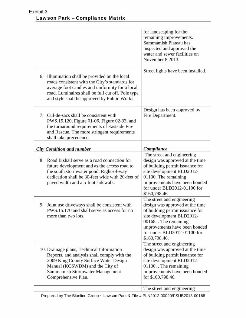
Lawson Park – Compliance Matrix
for landscaping for the remaining improvements. Sammamish Plateau has inspected and approved the water and sewer facilities on November 8,2013.
6. Illumination shall be provided on the local roads consistent with the City’s standards for average foot candles and uniformity for a local road. Luminaires shall be full cut off. Pole type and style shall be approved by Public Works.
Street lights have been installed.
7. Cul-de-sacs shall be consistent with
PWS.15.120, Figure 01-06, Figure 02-33, and the turnaround requirements of Eastside Fire and Rescue. The more stringent requirements shall take precedence.
Design has been approved by Fire Department.
City Condition and number
Compliance
8. Road B shall serve as a road connection for
future development and as the access road to the south stormwater pond. Right-of-way dedication shall be 30-feet wide with 20-feet of paved width and a 5-foot sidewalk.
The street and engineering design was approved at the time of building permit issuance for site development BLD2012-01100. The remaining improvements have been bonded for under BLD2012-01100 for $160,798.46
9. Joint use driveways shall be consistent with
PWS.15.170 and shall serve as access for no more than two lots.
The street and engineering design was approved at the time of building permit issuance for site development BLD2012-00168. . The remaining improvements have been bonded for under BLD2012-01100 for $160,798.46.
10. Drainage plans, Technical Information
Reports, and analysis shall comply with the 2009 King County Surface Water Design Manual (KCSWDM) and the City of Sammamish Stormwater Management Comprehensive Plan.
The street and engineering design was approved at the time of building permit issuance for site development BLD2012-01100. . The remaining improvements have been bonded for $160,798.46.
The street and engineering
Prepared by The Blueline Group ~ Lawson Park & File # PLN2012-00020/FSUB2013-00168
Exhibit 3

Lawson Park – Compliance Matrix
11. The Plattor shall document how the recommendations in the July 18, 2012, Pileated Woodpecker Investigation report prepared by The Watershed Company (Exhibit S-29) are addressed in the tree retention plan for the site.
design was approved at the time of building permit issuance for site development BLD2012-01100. . The remaining improvements have been bonded for $160,798.46.
12. A maximum 4-foot high, split rail or similar
type fence shall be installed along the outer boundary of the proposed wetland and buffer tract (currently labeled Tract E). Permanent sensitive/critical area signage shall be placed on this fencing at an interval of one (1) per lot or every 50 feet, whichever is less. Signs shall be a city approved type designed for high durability. Signs and fencing must be maintained by the property owner or homeowners’ association in perpetuity.
The site design was approved at the time of building permit issuance for site development BLD2012-01100. . The remaining improvements have been bonded for $160,798.46.
13. Address/monument signs are required to show
addresses on lots being served by common driveways. The sign must be placed to serve Proposed Lots 6, 7, 10, 25, and 26 fronting the street from which the houses are addressed.
Houses will be addressed through building permits and sign will be installed accordingly.
14. Addresses may need to be added to signs for
lots 8 and 9 if house numbers are not legible from the street. Inspectors will field verify.
Houses will be addressed through building permits and sign will be installed accordingly.
15. No parking is allowed in cul-de-sacs. “No
Parking-Fire Lane” signs are required to be installed.
No parking signs have been installed. The street and engineering design was approved at the time of building permit issuance for site development BLD2012-01100. . The remaining improvements have been bonded for $160,798.46 .
City Condition and number Compliance
16.No Parking is allowed on Road B.
Signage is required.
No parking signs have been installed. The street and engineering design was approved at the time of building permit issuance for site
Prepared by The Blueline Group ~ Lawson Park & File # PLN2012-00020/FSUB2013-00168
Exhibit 3

Lawson Park – Compliance Matrix
development BLD2012-01100. . The remaining improvements have been bonded for $.160,798.46
17. Parking is allowed only on one side of Road A.
Coordinate the non-parking side of the road with the side of the road fire hydrant may be installed on. “No Parking-Fire Lane” signs are required to be installed.
The street and engineering design was approved at the time of building permit issuance for site development BLD2012-01100. . The remaining improvements have been bonded for $160,798.46.
Conditions prior to final plat: 18. A barricade to prevent vehicular passage (of a
design, specifications, and location acceptable to the City) shall be placed across SE 14th Street somewhere between the east side of the Road A/SE 14th Street intersection and the east line of the plat until such time as the SE 14th Street right-of-way between the east line of the plat and 248th Avenue SE has been deeded to the City and a public street has been constructed within that right-of-way to a standard determined by the City to provide safe vehicular and pedestrian passage along its length. (This condition does not require this Plattor to construct such street improvements.) The barricade shall be marked to indicate that it is a temporary street end and that opening of the street is anticipated in the future.
The City has designed road improvements on SE 14th Street to the east of the plat. There is currently a barricade on SE 14th. The City is the process of obtaining the necessary deeds for the right of way of SE 14th Street. The portion of the street in the plat and engineering design was approved at the time of building permit issuance for site development BLD2012-01100. The remaining improvements have been bonded for $160,798.46.
19. Wetland hydrology function shall be
maintained for the offsite wetlands located immediately southwest of the subject development and in Tract F of Beaverdam Division 1.
Onsite drainage is collected and treated in two wet / detention ponds located in Tracts F and G. These two ponds are designed to mimic existing storm-water flows and durations and discharge the drainage through level spreader trenches directed to the offsite wetlands. The wetlands were not modified as part of this development. The design was approved at the time of building permit issuance for site development BLD2012-01100. . The remaining improvements have been bonded for
Prepared by The Blueline Group ~ Lawson Park & File # PLN2012-00020/FSUB2013-00168
Exhibit 3

Lawson Park – Compliance Matrix
$160,798.46.
20. At a minimum, all stormwater facilities shall
be constructed and online and operational. This includes construction of road ATB, curb, gutter, rain gardens, stormwater conveyance system, water quality treatment systems, and infiltration pond. Final lift of asphalt within the internal plat roads may be bonded except as indicated.
The street and engineering design was approved at the time of building permit issuance for site development BLD2012-01100. . The remaining improvements have been bonded for $160,798.46.
21. All new signs required in the public right-of-way must be installed by the City of Sammamish Public Works Department or at the direction of the City of Sammamish Traffic Engineer. Procurement and installation shall be paid for by the Developer. Contractor shall contact the Public Works Inspector to initiate signage installation a minimum of 6 weeks prior to final plat. Temporary street signs may be required for internal plat roads for emergency vehicle access. No parking signs shall be installed prior to final plat. No parking signs shall be required on all proposed street and private roads with clear widths of 20-foot or less.
The street and engineering design was approved at the time of building permit issuance for site development BLD2012-01100. The signs have been installed. The remaining improvements have been bonded for $.160,798.46
City Condition and number Compliance
22. A licensed surveyor shall survey and stake all storm drain facilities and conveyance lines with associated easements and dedications not located within the public right-of-way. Public Works Inspector shall inspect and approve locations.
The street and engineering design was approved at the time of building permit issuance for site development BLD2012-01100. Surveying monuments have been installed . The remaining improvements have been bonded for $160,798.46.
23. The storm drain system shall be jetted, cleaned,
and vactored and the system shall be televisioned for inspection.
The street and engineering design was approved at the time of building permit issuance for site development BLD2012-01100. The improvements have been inspected and approved by the City Public Works Construction Inspector. The remaining improvements have been bonded for $160,798.46.
The street and engineering
Prepared by The Blueline Group ~ Lawson Park & File # PLN2012-00020/FSUB2013-00168
Exhibit 3

Lawson Park – Compliance Matrix
24. All critical areas signs shall be installed.
design was approved at the time of building permit issuance for site development BLD2012-01100. The improvements have been inspected and approved by the City Public Works Construction Inspector. The remaining improvements have been bonded for under XX for $160,798.46. Critical Area Signs have been installed.
25. A Public Works performance bond shall be
posted consistent with the 2009 King County Surface Water Design Manual.
The street and engineering design was approved at the time of building permit issuance for site development BLD2012-01100. The improvements have been inspected and approved by the City Public Works Construction Inspector. The remaining improvements have been bonded for under XX for $160,798.46 .
26. Trees identified on the tree retention plan of
the preliminary plat have been retained pursuant to the provisions of SMC 21A.35.210. All trees shall be clearly tagged with numbers corresponding to the tree retention plan on file with the City. All trees to be retained in groups will be placed in tracts or Tree Retention Easements (T.R.E), except for individual trees on individual lots.
The construction, street and engineering design was approved at the time of building permit issuance for site development BLD2012-01100. The trees to be retained have been placed in Tree Retention Easements.
Conditions to appear on the face of the final plat:
27. “Tract D and portions of Lots 1-5, 13-31 are designated as tree retention areas. Retained trees are subject to the tree protection standards of Section 21A.35.230 of the Sammamish Municipal Code. Trees may not be removed from these tracts without approval from the City of Sammamish. Removal of these trees is prohibited unless the tree is removed to prevent imminent danger or hazard to persons or property. Contact the City of Sammamish to determine permit requirements. Trees removed subject to this provision shall be replaced in
Note 6, has been added to Sheet 2.
Prepared by The Blueline Group ~ Lawson Park & File # PLN2012-00020/FSUB2013-00168
Exhibit 3

Lawson Park – Compliance Matrix
compliance with SMC 21A.35.240.”
28. “No lot or portion of a lot shall be subdivided and sold, or resold, or its ownership changed or transferred in violation of applicable city, county, state, or federal standards, rules, regulations or laws.”
Note 3, has been added to Sheet 2.
City Condition and number Compliance
29. The developer shall comply with RCW
58.17.280, providing the appropriate “addressing note” with address ranges being on the final plat.
Note 4, has been added to Sheet 2.
30. “The proposed subdivision is subject to school
impact fees for the Issaquah School District, consistent with Chapter 21A.105 of the Sammamish Municipal Code. At the time of building permit, the developer shall pay one half of the required school impact fee, together with an administrative fee.”
Note 10, has been added to Sheet 2.
31. “The proposed subdivision is subject to parks
impact fees, consistent with Chapter 14A.20 of the Sammamish Municipal Code which shall be paid at the time of building permit issuance together with an administrative fee.”
Note 7, has been added to Sheet 2.
32. A surface water system development charge
shall be paid at the time of building permit issuance, for each new residential dwelling unit.”
Note 8, has been added to Sheet 2.
33. The developer shall include a note regarding
the payment of all traffic impact fees on the subject site consistent with the provisions of the Chapter 14A.15 of the Sammamish Municipal Code.
Note 5, has been added to Sheet 2.
Prepared by The Blueline Group ~ Lawson Park & File # PLN2012-00020/FSUB2013-00168
Exhibit 3

Lawson Park – Compliance Matrix
34. Surface Water Management Facilities required for this subdivision shall be contained within a separate tract of land and shall be dedicated to the City of Sammamish for maintenance and operation. Language to this effect as approved by the city shall be shown on the face of the final plat.
Tract provision 6 has been added to Sheet 2.
35. “Maintenance of all landscape strips including
the rain gardens along the internal plat roads shall be the responsibility of the Homeowners Association. Under no circumstances shall the City bear any maintenance responsibilities for landscaping strips created by the plat.”
Note 9, has been added to Sheet 2.
36. “Maintenance of landscaping strips along the
stormwater pond perimeter other than the interior pond embankments shall be the responsibility of the Homeowners Association.”
Note 12, has been added to Sheet 2.
City Condition and number Compliance
37. Covenant and easement language pertaining to individual lot and tracts with flow control BMPs shall be shown on the face of the final plat. Public Works shall approve the specific language.
Note 13, has been added to Sheet 2.
38. “Maintenance of illumination along all local
and private roads shall be the responsibility of the Homeowners Association or jointly shared by the owners of the development.”
Note 16 has been added to Sheet 2..
39. “Metal products such as galvanized steel,
copper, or zinc shall not be used in all building roofs, flashing, gutters, or downspouts unless they are treated to prevent metal leaching and sealed such that contact with storm water is prevented.”
Note 1, has been added to Sheet 2.
Prepared by The Blueline Group ~ Lawson Park & File # PLN2012-00020/FSUB2013-00168
Exhibit 3
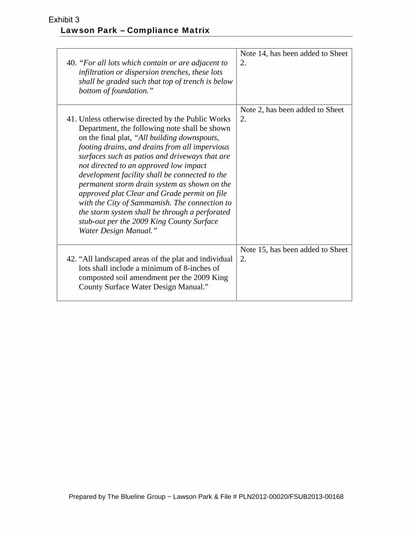
Lawson Park – Compliance Matrix
40. “For all lots which contain or are adjacent to
infiltration or dispersion trenches, these lots shall be graded such that top of trench is below bottom of foundation.”
Note 14, has been added to Sheet 2.
41. Unless otherwise directed by the Public Works
Department, the following note shall be shown on the final plat, “All building downspouts, footing drains, and drains from all impervious surfaces such as patios and driveways that are not directed to an approved low impact development facility shall be connected to the permanent storm drain system as shown on the approved plat Clear and Grade permit on file with the City of Sammamish. The connection to the storm system shall be through a perforated stub-out per the 2009 King County Surface Water Design Manual.”
Note 2, has been added to Sheet 2.
42. “All landscaped areas of the plat and individual
lots shall include a minimum of 8-inches of composted soil amendment per the 2009 King County Surface Water Design Manual.”
Note 15, has been added to Sheet 2.
Prepared by The Blueline Group ~ Lawson Park & File # PLN2012-00020/FSUB2013-00168
Exhibit 3


Exhibit 4

“ ” “ ”
Exhibit 4

Exhibit 4

Exhibit 4

Exhibit 4


Ariel Map, Lawson Park
The information included on this map has been compiled by King County staff from a variety of sources and is subject to change without notice. KingCounty makes no representations or warranties, express or implied, as to accuracy, completeness, timeliness, or rights to the use of such information.This document is not intended for use as a survey product. King County shall not be liable for any general, special, indirect, incidental, or consequentialdamages including, but not limited to, lost revenues or lost profits resulting from the use or misuse of the information contained on this map. Any sale ofthis map or information on this map is prohibited except by written permission of King County.
Date: 1/17/2013 Source: King County iMAP - Property Information (http://www.metrokc.gov/GIS/iMAP)
COMMENTS: PLN2012-00020
Exhibit S-13Exhibit 5

Ariel Map, Lawson Park
The information included on this map has been compiled by King County staff from a variety of sources and is subject to change without notice. KingCounty makes no representations or warranties, express or implied, as to accuracy, completeness, timeliness, or rights to the use of such information.This document is not intended for use as a survey product. King County shall not be liable for any general, special, indirect, incidental, or consequentialdamages including, but not limited to, lost revenues or lost profits resulting from the use or misuse of the information contained on this map. Any sale ofthis map or information on this map is prohibited except by written permission of King County.
Date: 1/17/2013 Source: King County iMAP - Property Information (http://www.metrokc.gov/GIS/iMAP)
Exhibit 5

City Council Agenda Bill Meeting Date: December 10, 2013 Date Submitted: December 4, 2013 Originating Department: Public Works Clearances:
City Manager Community Development Parks & Rec Attorney Finance & IT Police Admin Services Fire Public Works
Subject: Bridge Load Rating Contract – Inglewood Bridge Action Required: Authorize the City Manager to execute a contract agreement with AECOM Technical
Services, Inc. in an amount not to exceed $21,967 to provide engineering and professional services for bridge load rating calculations.
Exhibits: Agreement for Services Budget: $21,967 in the adopted 2013 Transportation Capital Improvement Fund
Summary Statement:
An updated load rating is needed for the Inglewood Bridge. The City has selected AECOM Technical Services, Inc.to perform the analysis.
Background:
The Inglewood Bridge (Bridge Number SAMMAM-03) is located on East Lake Sammamish Parkway NE, just north of NE 18th Place. This bridge was widened by the East Lake Sammamish Parkway Phase 1B improvement project in 2010. An updated load rating is required as a result of the modifications made to the bridge. The City is required to maintain a current load rating for all of the bridges in its inventory. The objectives of this work include evaluating the load carrying capacity of the current bridge and preparing a load rating report. The updated load capacity will be added to the National Bridge Inventory. AECOM Technical Services, Inc. was selected to perform this work because they were the firm that designed the bridge widening.
Financial Impact:
The cost of this work is an anticipated expense. The total contract amount is not to exceed $ 21,967. Included in this total is a management reserve fund in the amount of $1,997 to accommodate potential unknowns. The management reserve fund will only be utilized if determined necessary by City staff.
Recommended Motion:
Authorize the City Manager to execute a contract agreement with AECOM Technical Services, Inc. in an amount not to exceed $21,967 to provide engineering and professional services for bridge load rating calculations.
Page 1 of 1
Bill #2


Exhibit 1

Exhibit 1

Exhibit 1

Exhibit 1

Exhibit 1

Exhibit 1

Exhibit 1

Exhibit 1
Exhibit 1

Exhibit 1

Exhibit 1

Exhibit 1

City Council Agenda Bill Meeting Date: December 10, 2013 Date Submitted: December 5, 2013 Originating Department: Community Development Clearances:
City Manager Community Development Parks & Recreation Attorney Finance & IT Police Admin Services Fire Public Works
Subject: Resolution for 2015 Comprehensive Plan Rewrite (“Sammamish 2035”) Action Required: Review and Adoption Exhibits: 1. Proposed Resolution
Attachment A: City Council Reviewed Policy Topics Attachment B: Additional Policy Topics for City Council review
2. City of Sammamish Comprehensive Rewrite Schedule Budget: Adopted budget contains resources for known topics. See below as well.
Summary Statement The proposed resolution addresses City Council direction on the scope of items to be addressed during the Comprehensive Plan Rewrite process (aka Sammamish 2035). The City Council began work on this scope at the December 3, 2013 meeting, and will complete reviewing the remaining potential items at its December 10, 2013 meeting. The attached resolution directs staff to return to the City Council with a cost estimate for each item in the scope in the first quarter of 2014. Background In order to set a scope of work for the periodic update to the City’s Comprehensive, staff has been soliciting input from the City Council, appointed Commissioners, and general public on issues and policy ideas to include in this project. At the City Council’s December 3rd meeting, the Council reviewed a list of potential items compiled from a variety of sources including the joint City Council and Planning Commission meeting. The Council also took action on the density calculation pilot program proposed through the 2013 Docket, adding it to a broader effort to analyze the R-1 zone. The Council directed staff to include the two proposals for site-specific rezones received through the 2015 Docket in this analysis. All of these items are summarized in Attachment A to the resolution.
Page 1 of 2
Bill #3

City Council Agenda Bill On December 3rd, the Council completed review for many but not all of the suggested items. Still to be addressed are ideas recently submitted by Councilmember Whitten, and items developed in the Community and Economic Development Committee process. These are contained in Attachment B to the resolution.
Financial Impact
The financial impact of this action depends on which topics the City Council chooses to include in the Comprehensive Plan scope of work. Staff has included preliminary comments in the attachments, and once the Council finalizes the list of items to be included, staff will return in the first quarter of 2014 with an updated estimate. Recommended Motion Adopt the resolution
Page 2 of 2
Bill #3

CITY OF SAMMAMISH WASHINGTON
RESOLUTION NO. R2013 - XXX A RESOLUTION OF THE SAMMAMISH CITY COUNCIL RELATED TO TOPICS FOR CONSIDERATION IN THE 2015 COMPREHENSIVE PLAN REWRITE ALSO KNOWN
AS “SAMMAMISH 2035” WHEREAS, Sammamish adopted the city’s first Comprehensive Plan in 2003 (Ord. 2003-130) in accordance with the provisions of the Growth Management Act (GMA, RCW 36.70A.040); and
WHEREAS, the GMA requires cities in King County to review and revise their Comprehensive Plans by June, 2015 and every eight years thereafter with updated twenty-year growth targets and new or revised policies as needed (RCW 36.70A.130); and
WHEREAS, this work program item has been known as the 2015 Comprehensive
Plan Rewrite (CPR) and by the proposed name of “Sammamish 2035”; and WHEREAS, the GMA requires a number of mandatory elements such as Land
Use and Transportation to be included in a local Comprehensive Plan, and also provides for locally chosen additional elements; and
WHEREAS, three new elements (Economic Development, Shorelines and
Sustainability) have been identified for inclusion in Sammamish 2035; and WHEREAS, in the last few years the City Council has identified a number of topics for review and consideration as a part of the Sammamish 2035 process and those are shown in Attachments A; and WHEREAS, in 2013 the City Council Community and Economic Development Committee has identified several economic development topics for review and consideration as a part of the Sammamish 2035 process as shown in Attachment B; and WHEREAS, city code provides for solicitation and review of proposals from private parties to amend the city Comprehensive and this process is known as the annual docket; and WHEREAS, in September 2013 the City solicited proposed comprehensive plan amendment docket requests for consideration as a part of the Sammamish 2035 process and those requests have been evaluated by city staff are included in Attachment A; and WHEREAS, the City Council has directed staff to schedule in early 2014 an opportunity for the Council to review the adopted Vision Statement and provide additional policy direction for the Sammamish 2035 process, and to solicit input from the Planning Commission in doing so; and
Exhibit 1

WHEREAS, the Sammamish 2035 process includes an extensive Public
Involvement Plan (PIP), with outreach to residents, businesses, organized stakeholder groups and younger people through a variety of methods; and
WHEREAS, following public input and review of proposed revised elements of
the new Plan, the Planning Commission is charged with developing a recommendation to the City Council; and
WHEREAS, the City Council has allocated resources in the adopted city budget
to complete the Sammamish 2035 process based on a scope of work developed by staff; and WHEREAS, it is anticipated that through the public process additional topics for consideration in Sammamish 2035 may be proposed and if pursued may also require additional resources to complete the necessary analysis and documentation; and WHEREAS, staff should continue to provide the City Council with analysis and recommendations as to topics for consideration in the overall scope of work; and
WHEREAS, a working schedule for Sammamish 2035 has been developed and is shown as Exhibit 2 to this Resolution; and
WHEREAS, the city intends to make best efforts to complete the Sammamish 2035 process as shown on the schedule, and the City Manager and staff will keep the City Council apprised on a regular basis of progress. NOW, THEREFORE, THE CITY COUNCIL OF THE CITY OF SAMMAMISH, WASHINGTON, RESOLVES AS FOLLOWS: Section 1. City Council Identified Topics. Staff is directed to include the list of topics shown in Attachments A and B in the Sammamish 2035 scope of work. For those topics requiring additional resources, staff is directed to return with a cost estimate in the first quarter of 2014 for City Council review.
Section 2. Community and Economic Development Committee Policy Changes. Staff is directed to review the list of topics shown in Attachment B for potential inclusion in the Sammamish 2035 scope of work and to return with a cost estimate in the first quarter of 2014 for City Council review. Section 3. Effective Date. This resolution is effective immediately upon adoption. Section 4. Severability. Should any section, paragraph, sentence, clause or phrase of this Resolution, or its application to any person or circumstance, be declared unconstitutional or otherwise invalid for any reason, or should any portion of this Resolution be pre-empted by state or federal law or regulation, such decision or pre-emption shall not affect the validity of the remaining portions of this Resolution or its application to other persons or circumstances.
2
Exhibit 1

ADOPTED BY THE CITY COUNCIL AT A SPECIAL MEETING THEREOF ON THE____ DAY OF DECEMBER, 2013 CITY OF SAMMAMISH ______________________________ Mayor Thomas T. Odell ATTEST/AUTHENTICATED: Melonie Anderson, City Clerk ______________________________ Approved as to form: ______________________________ Mike Kenyon, City Attorney Filed with the City Clerk: November 27, 2013 Passed by the City Council: Resolution Number
3
Exhibit 1


Attachment A: City Council-Reviewed Comprehensive Plan Rewrite Policy Topics
Policy Topic Policy Direction Staff Comment Resources Needed Council Direction 1. Housing A. Expand policies that
promote housing type diversity, especially for seniors
• Can be considered in Housing Element
Already included
B. Review affordable housing requirements, emphasize incentives
• Can be considered in Housing Element
Already included
2. Environment & Sustainability
A. Maintain strong environmental protections
• Review goals and policies in current Plan
• Identify new policies in Sustainability Element
Already included
B. Consider policies promoting new technologies (smart metering, electric fleets, grey water systems)
• Research supportive policies from other jurisdictions
Uncertain, likely low
C. Consider policies to maximize site use while protecting environmental quality
• Research code examples, design techniques; derive potential policies
Uncertain, likely low
(Combine with study of
R-1 zone directed by motion passed by CC
12/3/13) D. Consider lower impact fees for more tree retention
• Combines impact fee system with tree retention
Uncertain, likely high
(See also item 7C)
1

Attachment A: City Council-Reviewed Comprehensive Plan Rewrite Policy Topics
E. Review buffer requirements around environmentally critical areas
• May be regulatory instead of policy issue
• ECA recently completed using BAS
Uncertain, likely high
3. Commercial Land
Uses A. Review list provided by Scott Hamilton regarding flexibility in commercial zones; Allow hardware stores in commercial zones
• Include policy issues in review of Land Use Element
• Some suggestions may be regulatory
Uncertain, likely low
4. Transportation and Infrastructure
A. Consider policies to expand services and jobs
• Need transportation and land use analysis
Uncertain, likely medium
B. Do not neglect utilities and infrastructure;
• Include in Utilities and Public Services Element
Already included
C. Policies to promote improved transit for local residents
• Create list of supportive policies
• Review regional transit service provider plans
Medium
D. Promote complete streets, enhance internal connectivity of non-motorized facilities
• Include in Transportation Element
Already included
E. Coordinate with water and sewer districts to ensure plans are consistent
• Required by State Law Already included
2

Attachment A: City Council-Reviewed Comprehensive Plan Rewrite Policy Topics
5. Citizen survey A. Incorporate data from recent citywide survey
• Can be included in PIP process
Already included
6. Klahanie PAA A. Include Klahanie PAA pursuant to adopted Council resolution
• Since effort would be large, staff recommend awaiting result of annexation vote
High
(Do not begin work until after vote on
annexation.) 7. Land Use A. Explore potential
locations for hotels/other lodging.
• Review locations of commercial zones, allowed uses in current zones
• Develop policies to promote new lodging uses
Uncertain, likely medium
(Small effort—add hotel as land use category in
some zones.) 8. Parks A. Expand uses at
Sammamish Landing; develop equestrian facility; add senior/activity center to Big Rock Park; find use for YMCA property next to PLMS; coordinate with school districts and neighboring cities on regional competitive pools
• Review policy language related to Parks
• Many of these ideas may be more appropriate for capital plan discussions
Uncertain, likely medium (Separate effort from Comprehensive Plan)
9. Wildlife habitat A. Review policies that support wildlife protection
• Review peer jurisdictions
• Consider relationship to recent ECA work
Uncertain, likely low
3

Attachment A: City Council-Reviewed Comprehensive Plan Rewrite Policy Topics
10. Notch UGA change A. Pursue amendment to Urban Growth Area boundary with King County in 2016
• Review relevant changes to ownership since 2012
• Consider policies related to UGA change proposals
Uncertain, likely medium
11. Aldarra Golf Club and Boeing property
A. Review land use and zoning designations
• Previously studied in 2007
• Unsure of land owner interest and goals
Uncertain, likely medium
12. Pine Lake Village A. Undertake new subarea planning process
• Future action High (Separate effort from Comprehensive Plan)
13. Sammamish Highlands
A. Undertake new subarea planning process
• Future action High (Separate effort from Comprehensive Plan)
Supplement 1 to Exhibit 2
Policy Topic Policy Direction Staff Comment Resources Needed Council Decision 7. Land Use B. Research need and
consider policies to promote compatibility between adult homes, schools, and churches and surrounding residential uses.
• Can be considered in Land Use Element
• Policies must be consistent with state law and other legal requirements.
Uncertain, likely medium
C. Review tree retention policies and replanting policies. Also consider additional incentives.
• Can be considered in Land Use Element
Uncertain, likely low
4

Attachment A: City Council-Reviewed Comprehensive Plan Rewrite Policy Topics Supplement 2 to Exhibit 2
Policy Topic Policy Direction Staff Comment Resources Needed Council Decision 14. 2015 Docket
Proposal--Timmerman
• Recommend against advancing
• If City Council would like to study further, recommend considering area-wide rezone
(Combine with study of R-1 zone directed by motion passed by CC
12/3/13)
15. 2015 Docket Proposal—Conley/Reid
• Recommend against advancing
• If City Council would like to study further, recommend considering area-wide rezone
(Combine with study of R-1 zone directed by motion passed by CC
12/3/13)
5


Attachment B: Additional Policy Topics for City Council review
Policy Topic Policy Direction Staff Comment Resources Needed 16. Pilot programs Identify when a pilot
program is appropriate, objectives of specific pilot program, criteria for selection of project best suited to test program, etc.
• Can be considered in Land Use Element
Low
17. Land Use A. Rezone of properties in No Disturbance area to R-1 and whether there should be any change to allow development in the No Disturbance zone
• Would require significant outreach, consultation with affected property owners and analysis
Medium
B. Rezone of properties on slopes over 15% to R-1
• Would require study; can be considered Environment & Conservation Element
Medium
C. Regulation with reasonable requirements those uses which are not residential which are permitted in residential zones under preemptive State law, including adult homes, churches, etc. Adding additional commercial zoned areas and permitted uses in those areas
• CC declined to include in scope (item 7B from Exhibit 2)
N/A
D. Comprehensive Tent City Ordinance
• Review Land Use and Housing Element Goals and Policies to include supportive policies
Already directed by Council
December 10, 2013 1

Attachment B: Additional Policy Topics for City Council review
18. Housing A. Reducing the 10% affordable housing mandate and 10% optional element in Town Center
• Would require review of Town Center Plan; existing Housing Element goals
Medium
B. Look at imposing 5 % affordable housing mandate and 5% discretionary affordable housing element in other subarea plans (PL Center and Samm. Highlands SC).
• Subarea plans out of scope, per CC consensus at 12/3/13 meeting
Medium
C. Should we look at incentives and /or mandate to include affordable housing in residential projects over a certain size, e.g. over 9 homes? If incentives, what should those be (more density?)?
• Include in review of Housing Element
• Review available relevant economic and demographic data to determine level of need for affordable housing
Medium
D. Review and revise existing, adopted housing policy which is a canned program and does not fit Sammamish, especially with reference to things like existing mobile home parks, review of home style/designs, etc.
• Included in review Housing Element
(Included)
19. Sustainability/Environment A. Look at eliminating Low Impact Development ordinance and adding a new one
• Add to review of Sustainability Element
Low
December 10, 2013 2

Attachment B: Additional Policy Topics for City Council review
B. Look at increasing tree retention in private development.
• Consider adding supportive policies in Environment & Conservation Element
Approved as item 7C (see Exhibit 1 Att. A)
C. Look at our city --or at least to be identified areas of it--, becoming an “urban forest” with the focus on tree retention and reforestation on public rights of ways and city properties.
• Consider adding supportive policies in Environment & Conservation or Land Use Element
Included in approval of item 7C (see Exhibit 1 Att. A)
20. Town Center/Economic Development
A. Review Town Center Plan. Revisit vision, identify elements to be reviewed. Consider implications of changes on land use, environmental regulations.
• Include discussion of plan changes during review of Land Use and Environment & Conservation Elements.
• Need to conduct public outreach, gather public input on vision ideas.
See item 22 in Exhibit 1 Att. A
21. Parks A. Look at a city wide policy for ADA access to all parks with minimum standards and standards that are desirable but not mandated
• Research existing federal and state requirements
• May be better addressed through separate development regulation change
(Separate effort from Comprehensive Plan. See item 8A in Exhibit 1 Att. A)
B. Take a citywide, 30,000 foot look at all of our parks’ master plans and re-assess whether as a whole they are desirable or if there should be some modifications to make some of them more modest.
• Parks, Recreation and Open Space Plan completed in 2012—may address some concerns
(Separate effort from Comprehensive Plan. See item 8A in Exhibit 1 Att. A)
December 10, 2013 3

Attachment B: Community and Economic Development Committee Policy Changes
Policy Topic Policy Direction Staff Comment Resources Needed 22. Economic
Development A. Consider redistributing the commercial square footage allowances across the five A-zoned mixed-use areas
• Requires property owner and public input, traffic study
Medium
B. Consider rezoning selected A and B zones to better concentrate mixed uses in fewer areas
• Requires property owner and public input, traffic study
Medium
C. Review and potentially revise affordable housing requirements
• Similar to Items 18 A-C above
See item 18A in Exhibit 1 Att. A
December 10, 2013 4

Exhibit 2


Memorandum Date:
December 5, 2013
To:
Ben Yazici
From:
Kamuron Gurol
Re:
Tree Retention and Code Compliance
The City Council will be discussing the above-referenced topics on December 10, 2013. Attached to this memo are:
• The PowerPoint presentation I intend to use to provide an overview of our retention policies and code
• A comparison of tree retention requirements for selected peer cities • A comparison of tree removal codes for the same cities
Tree Retention Staff provided information to the Council in March 2012 on our tree retention code and staff’s observations to improve the administration of that code. Also we have provided updates from time to time since then as questions have arisen. In general, I believe our implementation of adopted code and the results on the ground have improved in the last year and a half. Specifically we have:
• Expanded the use of arborist recommendations • Retained trees in separate tracts, not individual lots • Improved the use of construction fencing and inspections • Allowed sidewalks and walkways to meander where appropriate • Improved the likelihood of success for retained trees after development • These techniques have resulted in better performance under our adopted standard
Reviewing the retention comparison chart, I find that Sammamish regulations are similar to our peer cities. Some cities use tree diameter instead of tree quantity as the metric, and this is a way to favor retention of larger trees. Other jurisdictions also require retention on individual lots less than one acre, which Sammamish does not require. Staff looks forward to the Council’s policy discussion and direction next week.
1
Bill #4

Code Compliance At any given time, our code compliance caseload includes several cases of unpermitted tree removal, usually on individual lots rather than as a part of a permitted land use action. In a few cases, the clearing involves significant numbers or is done on sensitive sites, like steep slopes, and often to improve views or provide other perceived benefits. As you can see from the comparison chart, Sammamish’s fines are minimal for small scale unpermitted clearing outside of critical areas. Other cities have higher fines and they vary in how the fine amounts are determined. Most cities add to penalty amount for repeat violators, as we do. For unpermitted clearing in a critical area, our penalty amounts can be much higher and the amount for repeat violators rises steeply to $25,000. We do not have a ‘per-tree’ mechanism however as others do. Our code compliance chapter and administrative rule for fine amounts have not yet been frequently applied and tested so we can offer only minimal comment on the effectiveness of current code. Staff looks forward to the Council’s policy discussion and direction next week. Other options This week staff received policy direction from the City Council to include review of tree retention policies as a part of the Comprehensive Plan Rewrite process in the coming two years. There may be mechanisms that would complement our current retention-based policies and provide additional positive results to help ‘keep us green.’ These could include planting programs, Tree City USA programs, education and others. We should discuss these as the Comprehensive Plan progresses. Please let me know if you have questions, thanks!
2
Bill #4

TREE RETENTION December 10, 2013
City Council discussion and direction Exhibit 3

Goals for tonight
• Overview of current tree retention code and recent implementation improvements
• Comparison to peer cities
• Overview of code compliance issues
• Council policy direction for staff and Planning Commission work in 2014
Exhibit 3

Tree Retention Code - Overview
• Significant trees are:
• Coniferous trees 8 inches in diameter or greater
• Deciduous trees 12 inches in diameter or greater
• New subdivisions, short plats: Retain 25%
• Commercial and institutional: Retain 30%
• Up to 50% of retained trees can be located in ECAs and buffers
Exhibit 3

Criteria for retention
• Healthy trees in groups or stands, not isolated
• Reasonable chance of survival after development
• Do not pose a hazard to people or property
• May be incorporated into required landscaping
• Removal requires permission and replacement • 4:1 for trees 8” to 12” • 6:1 for trees 12” to 16” • 8:1 for trees16” or greater
Exhibit 3

SMP tree retention
• Pine and Beaver Lakes • 80% tree retention
• Lake Sammamish • Retain significant trees within the 50 foot setback
• If removed for setback reduction, then replace at 2:1
Exhibit 3

Staff report March 2012
• Use arborist recommendations
• Retain trees in separate tracts, not individual lots
• Construction fencing and inspections
• Allow sidewalks and walkways to meander
• Tag retained trees for homeowner’s future reference
Exhibit 3

Example of tree protection fencing
Exhibit 3

Tree retention tract adjacent to a recreation tract
Exhibit 3

The same tract showing the recreation area Exhibit 3

Individual tree stand on a single family lot protected by retaining walls and fencing
Exhibit 3
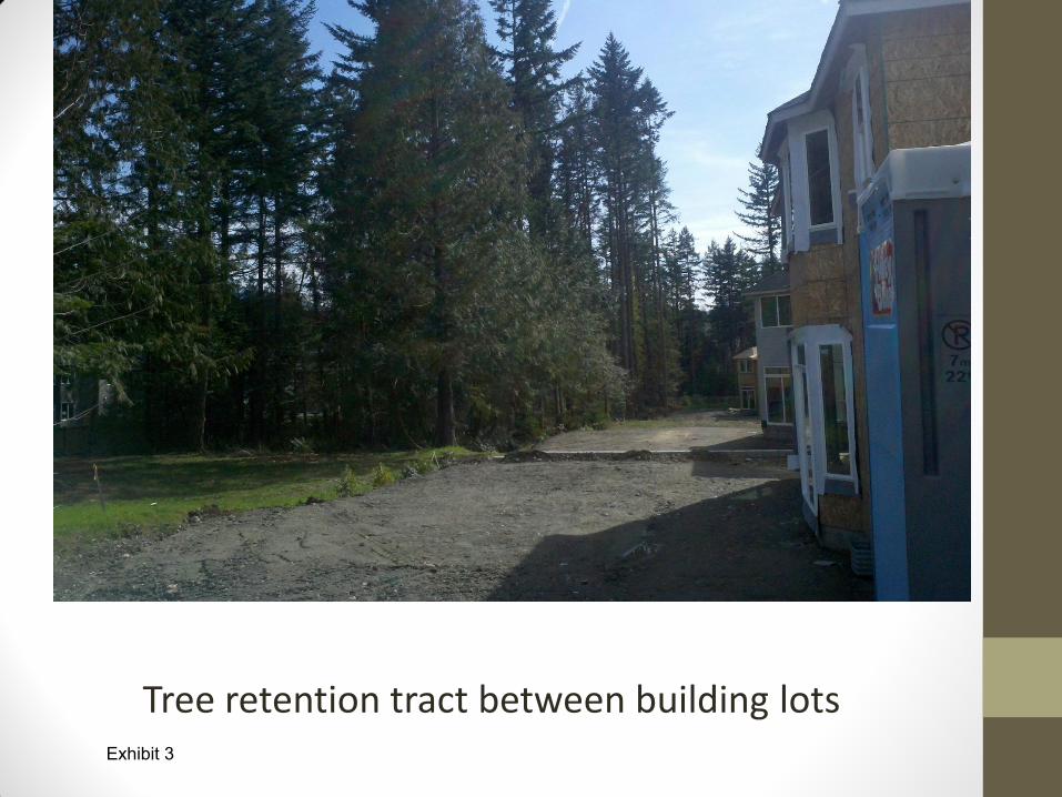
Tree retention tract between building lots Exhibit 3

QUESTIONS? Exhibit 3

RED
MO
ND
IS
SAQ
UA
H
KIR
KLA
ND
B
ELLE
VU
E
Determined by lot size.
Minimum 35% of all sig-nificant trees.
Minimum 35% of all sig-nificant trees
(Lot size in square
ft./43,560) X 30 = Re-quired minimum tree density. Minimum of 30 tree credits
(Lot size in square ft./43,560) X 30 = Re-quired minimum tree density. Minimum of 30 tree credits.
(Lot size in square ft./43,560) X 30 = Re-quired minimum tree density. Minimum of 30 tree credits.
Typically, 30% of the diam-eter inches of the signifi-cant trees existing. Alder and Cottonwood diameter inches shall be discounted by a factor of 0.5.
Typically, 30% of the diame-ter inches of the significant trees existing. Alder and Cottonwood diameter inch-es shall be discounted by a factor of 0.5.
Typically, 30% of the diame-ter inches of the significant trees existing. Alder and Cottonwood diameter inch-es shall be discounted by a factor of 0.5.
30% of the total caliper (dbh) of all significant trees in developable site area.
Single Family Subdivision Short Plat
TREE RETENTION REQUIREMENTS SA
MM
AM
ISH
No retention require-ments if under an acre.
25% of the significant trees.
25% of the significant trees.
30% of the total caliper (dbh) of all significant trees in developable site area.
30% of the total caliper (dbh) of all significant trees in developable site area.
Exhibit 1


RED
MO
ND
IS
SAQ
UA
H
KIR
KLA
ND
B
ELLE
VU
E
Residential Permits are free. Commer-cial permits are $115.11. Civil Pen-alties up to $3000 per tree.
Residential Permits are free. Commer-cial permits are $115.11. Civil Pen-alties up to $3000 per tree.
Residential Permits are free. Com-mercial permits are $115.11. Civil Penalties up to $3000 per tree.
First Time Violator: $1000 Repeat Violator: $1000 + Restoration
First Time Violator: $1000 Repeat Violator: $1000 + Restoration
First Time Violator: $1000 Repeat Violator: $1000 + Restoration
First Time Violator: $200 per tree or value. Repeat Violator: $200 per tree or value + Pen-alty Scale up to $5000 (can be doubled)
First Time Violator: $200 per tree or value. Repeat Violator: $200 per tree or value + Pen-alty Scale up to $5000 (can be doubled)
First Time Violator: $200 per tree or
replacement value. Repeat Violator: $200 per tree or replacement value + Penalty Scale up to $5000 (can be doubled)
$250 per day + may owe 3x damage based on specified criteria.
$250 per day + may owe 3x damage based on specified criteria.
Not to exceed $25,000 based on na-ture and gravity of violation.
Unpermitted Tree Removal Unpermitted Tree Removal in Critical Area
1-3 Trees removed
One or more trees removed without a permit.
4 or More Trees removed
COMPARISON OF NEIGHBORING CITIES TREE REMOVAL POLICY SA
MM
AM
ISH
No fee tree removal permit.
No fee tree removal permit.
First Time Violator: Permit Cost + Cost of Restoration + Up to $15,000 Environmental Penalty. Repeat Violator: Permit Cost + Cost of Restoration + $25,000 Environ-mental Penalty
Exhibit 2