Citta paper morais_p.costan.m
17
CITTA 6 th Annual Conference on Planning Research RESPONSIVE TRANSPORTS FOR SMART MOBILITY 1 THE PUBLIC TRANSPORTS AND THE MOBILITY OF MOTOR DISABLE CITIZENS IN MUNICIPALITY OF LISBON Pedro Morais; Rafael Guerreiro, Nuno Marques da Costa IGOT- Universidade de Lisboa Institution, email. [email protected]; [email protected] Phone/fax numbers: 21 794 02 18 / 21 793 86 90 Abstract The Geographic Information Systems (GIS) are a powerful and efficient tool for multiple areas of knowledge, namely as a support decision tool. Its use on transport management and as a support decision tool for understanding citizens’ mobility represents an advantage that goes beyond route management or information displayed to different users (MILLER, 2001). By using GIS as a resource we’re able to do an evaluation about the conditions of public transports services in the municipality of Lisbon for people with motor disabilities. To do that it was necessary to create a database with the pedestrian network, road network, rail network and fluvial network for the development of a Multimodal network model of Lisbon’s public transports. Mobility for everyone is considered as the ability that the environment has to bring all the citizens an equal opportunity of enjoyment of space in a direct, permanent and secure form in the most independent way possible and as a benefit for all. That is why it is necessary to understand where the accessibility problems are and how they will affect the mobility off disabled citizens but also all people that doesn’t have any kind of impairments. According to several conclusions from the Municipal Regulation for the Promotion of Accessibility and Pedestrian Mobility of Lisbon’s Municipality, the city of Lisbon excludes some people, requires tremendous effort to others and it’s a cause of discomfort and insecurity for the majority. In this context this project has the purpose to create a tool to support decisions which will be the key to understand where the resources need to be used as in the adaptation of the existent public transports equipment as to stop the creation of new barriers against the accessibility of these citizens. Keywords: Network Analysis; Public Transport; Motor Disabled Citizens; Lisbon.
-
Upload
pedro-morais -
Category
Documents
-
view
107 -
download
0
Transcript of Citta paper morais_p.costan.m

CITTA 6th Annual Conference on Planning Research
RESPONSIVE TRANSPORTS FOR SMART MOBILITY 1
THE PUBLIC TRANSPORTS AND THE MOBILITY OF
MOTOR DISABLE CITIZENS IN MUNICIPALITY OF
LISBON
Pedro Morais; Rafael Guerreiro, Nuno Marques da Costa
IGOT- Universidade de Lisboa
Institution, email. [email protected]; [email protected]
Phone/fax numbers: 21 794 02 18 / 21 793 86 90
Abstract The Geographic Information Systems (GIS) are a powerful and efficient tool for multiple areas of knowledge,
namely as a support decision tool. Its use on transport management and as a support decision tool for
understanding citizens’ mobility represents an advantage that goes beyond route management or information
displayed to different users (MILLER, 2001). By using GIS as a resource we’re able to do an evaluation about
the conditions of public transports services in the municipality of Lisbon for people with motor disabilities. To do
that it was necessary to create a database with the pedestrian network, road network, rail network and fluvial
network for the development of a Multimodal network model of Lisbon’s public transports.
Mobility for everyone is considered as the ability that the environment has to bring all the citizens an equal
opportunity of enjoyment of space in a direct, permanent and secure form in the most independent way possible
and as a benefit for all. That is why it is necessary to understand where the accessibility problems are and how
they will affect the mobility off disabled citizens but also all people that doesn’t have any kind of impairments.
According to several conclusions from the Municipal Regulation for the Promotion of Accessibility and
Pedestrian Mobility of Lisbon’s Municipality, the city of Lisbon excludes some people, requires tremendous effort
to others and it’s a cause of discomfort and insecurity for the majority. In this context this project has the
purpose to create a tool to support decisions which will be the key to understand where the resources need to
be used as in the adaptation of the existent public transports equipment as to stop the creation of new barriers
against the accessibility of these citizens.
Keywords: Network Analysis; Public Transport; Motor Disabled Citizens; Lisbon.
P.MORAIS, R. GUERREIRO, N.M.COSTA “THE PUBLIC TRANSPORT AND THE MOBILITY OF MOTOR DISABLE
CITIZENS IN THE MUNICIPALITY OF LISBON”
2
1 Introduction
Cities’ growth and the increase of volume and range of commuting travels led to the implementation
of collective public transports which improved the mobility conditions in urban centres and allowed
its extension. In Lisbon’s Municipality public transports were equally important for the development
of the city, especially during the 40’s of the past century, period of time in which started a strong
population growth in the city and in its Metropolitan Area.
Nowadays the public transports presents us a variety of valuable features compared to the
individual transports, mainly when we think about the environmental impacts due to the daily needs
of travels in urban areas, but they are clearly the only alternative for mobility of a great part of the
population. In this group we encounter the disabled citizens with visual, motor, temporarily or
definitive malformations.
The public transports services should be able to attend every citizen and to do so they should be
adapted to the necessities of the disabled ones. In the case of motor disabled citizens it is required
the existence of adapted transports such as buses with a downtrend floor, to be easier to enter and
to exit the adapted vehicle and in the stations an elevator to the platforms. The main problems that
a motor disabled citizen still faces are the result from the absence of those equipment’s or even the
inoperability of some of them , often happening because of the flaws on maintenance or even still
when some are not adjusted to the specific mobility issues, such as the passage to access
channels or the absence of access ramps. These situations diminish the mobility of motor disabled
citizens. However, the difficulties felt by these citizens don’t result only from the absence or
malfunctions of these equipment’s usually both stations and transportation units are equipped but
the difficulties come from the surrounding areas that aren’t prepared to those citizen’s necessities.
The lack of reserved parking seats, the absence of lowered sidewalks for crossing, the presence of
an irregular floor or even the improper parking on sidewalks and on the access to bus stops
preventing the normal operation of buses equipped with access ramps are some of the obstacles
that can be found .
So the specific objectives of this work are to understand which are the service areas of public
transports in Lisbon’s Municipality that are adapted for these motor disabled citizens, the influence
areas of the underground and fluvial stations adapted to motor disabled citizens and finally the
determination of Lisbon’s public transports routes that are served in a higher or lower degree by the
adapted public transports for motor disabled citizens. It is imperative to be able to understand the
differences and flaws that overall public transports offer, specially to motor disabled citizens and by
that trying to think in alternatives, new methods to improve the current infrastructures and the
replacement of old equipment’s with new adapted ones to increase the mobility of this citizens and
consequently improve the social inclusion of all citizens in Lisbon’s Municipality.
In order to do so, this project was developed on a Geographical Information System (GIS) to model
the accessibility to public transports in Lisbon’s municipality .One of the main components used
was the group of gathered georeferenced data of public transports entities at a scale of 1:10 000.
This data was stored on a spatial database that grants an advanced integrity level (BUTLER, 2008).
This work’s methodology was divided in 3 phases starting with the acquisition and storage of
georeferenced information followed by the conceptualization of the Multimodal Network made from

CITTA 6th Annual Conference on Planning Research
RESPONSIVE TRANSPORTS FOR SMART MOBILITY 3
the gathered data of public transports network focusing on the adapted equipment for the motor
disabled persons. Finally there were made several network analyses using the Network Analyst
extension of ArcGIS software on a multimodal network.
2 Description of the Case Study
Lisbon’s Municipality is the case study which is at the same time the biggest city in Portugal and the
most influent one as the economic and political centre. Lisbon is also the main unit of the
Metropolitan Area of Lisbon which integrates the Great Lisbon cluster. It contains the municipalities
of Amadora, Cascais, Loures, Mafra, Odivelas, Oeiras Sintra and Vila Franca de Xira on the right
bank of Tagus river and on the left bank the Setúbal Peninsula that has the Almada, Alcochete,
Barreiro, Moita, Montijo, Palmela, Seixal and Setúbal municipalities.
Figure 1. The case study territorial frame
The municipality of Lisbon (Figure 1) presents an area of 84,9 km² and a population of 547.733
inhabitants (according to the 2011 Census) unevenly divided by fifty-three parishes. The
Metropolitan Area of Lisbon has a population of 2.821.876 inhabbitants that is around 27% of the
Portuguese population (2011 Census). Geographically speaking Lisbon’s municipality has
boundaries with Loures and Odivelas municipalities on the North side, Amadora on the Northwest,
Oeiras to the West and to the South and Southeast the Tagus’s Estuary that connects with the
municipalities of the South shore which are Almada, Seixal, Barreiro, Alcochete and Moita.
The selection of this work area has to do with the municipality where the fastest transformations
and population dynamics took place. The boost of buildings, number of residences and employment
P.MORAIS, R. GUERREIRO, N.M.COSTA “THE PUBLIC TRANSPORT AND THE MOBILITY OF MOTOR DISABLE
CITIZENS IN THE MUNICIPALITY OF LISBON”
4
offer (Costa, 2007) enabled the presence of a public transports network that tries to be quick and
efficient at answering the general population needs and so we intent to understand if these public
transports also possess an arranged answer to the motor disabled citizens
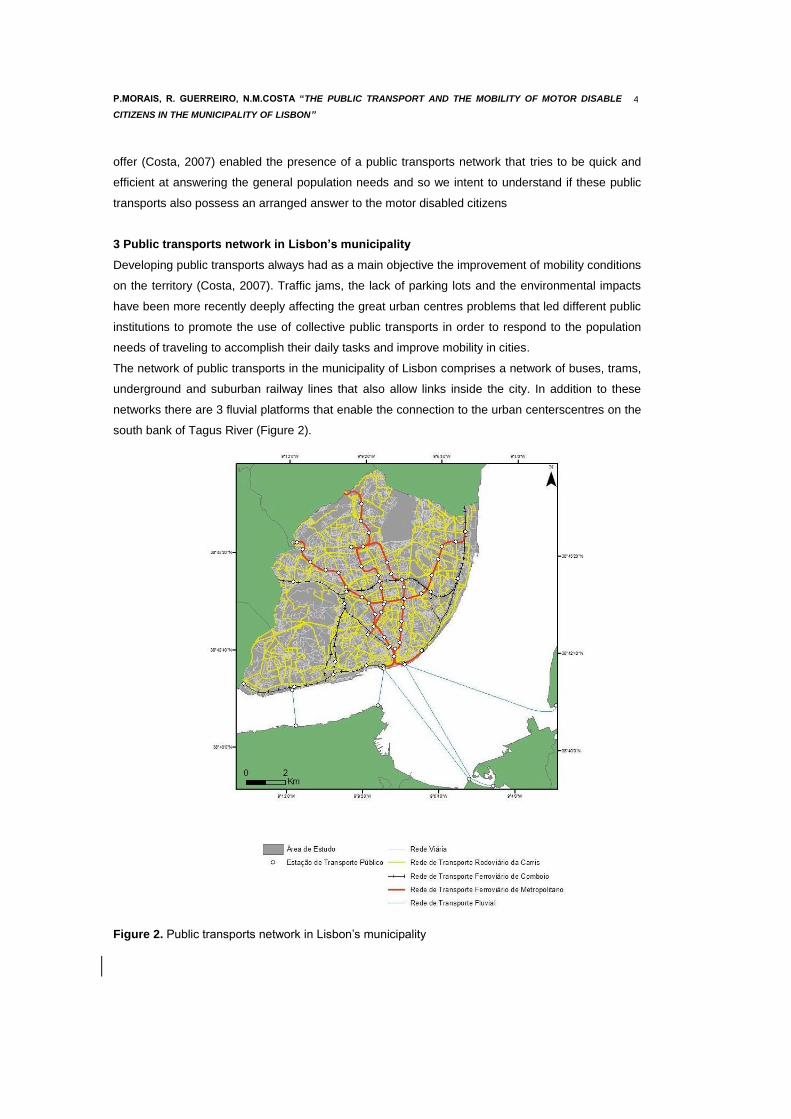
3 Public transports network in Lisbon’s municipality
Developing public transports always had as a main objective the improvement of mobility conditions
on the territory (Costa, 2007). Traffic jams, the lack of parking lots and the environmental impacts
have been more recently deeply affecting the great urban centres problems that led different public
institutions to promote the use of collective public transports in order to respond to the population
needs of traveling to accomplish their daily tasks and improve mobility in cities.
The network of public transports in the municipality of Lisbon comprises a network of buses, trams,
underground and suburban railway lines that also allow links inside the city. In addition to these
networks there are 3 fluvial platforms that enable the connection to the urban centerscentres on the
south bank of Tagus River (Figure 2).
Figure 2. Public transports network in Lisbon’s municipality
CITTA 6th Annual Conference on Planning Research
RESPONSIVE TRANSPORTS FOR SMART MOBILITY 5
Carris, the company who holds Lisbon’s surface public transports is responsible for buses, trams
and 3 lift-trams services and one lift on the city of Lisbon even ensuring some connections to
parishes of neighboring Lisbon’s municipalities. The buses network has 87 routes (59 urban, 18
suburban, 9 at dawn and 1 night bus) that goes over 678 kilometers, having carried over 214 million
passengers in 2011. The tram network has 5 routes and with the help of the 3 lift-trams and the one
lift was responsible for carrying 18 million passengers in 2011. Despite the effort of having better
conditions for the access of motor disabled citizens, only 25 of the entire Carris routes are
completely adapted to fulfill the necessary requisites.
The underground network is operated by the Metropolitano de Lisboa (ML) company and has 4
lines, 52 stations (6 correspondence stations between lines) and a length of 33,6 km having carried
in 2011 over 180 million passengers. When the survey was made the underground network
presented 52 stations served by 209 escalators, 95 lifts and 10 moving walkways however only 31
of the 52 stations have the conditions to the full accessibility of motor disabled citizens. Meanwhile
in July 2012 there were inaugurated 3 new stations with full accessibility to citizens with reduced
mobility and the network now extends to 43,2 km.
The suburban railway network that serves Lisbon’s urban area has 4 lines (Cascais, Sintra,
Azambuja, and the North-South Axis) crossed by a circular line. CP and Fertagus are the operators
having carried more than 155 million passengers in 2011 (127 million passengers in CP and 28
million in Fertagus). The train stations and platform accesses have in general the necessary
conditions to the full accessibility of the motor disabled citizens.
There are also 3 fluvial stations in the city that carried in 2011, 27,5 million passengers. Over the
years the company of fluvial transport, Transtejo has been investing on the upgrade and adaptation
of those stations infrastructures in order to improve the access conditions for the motor disabled
persons but there are still some architectural barriers limiting the access to the ships by the citizens
that use wheelchairs has it happens in the Belém station.
4 The concept of a motor disabled person
A motor disabled person is an individual that by lesion or deformation, congenital or acquired, has a
degree of incapacity equal or superior to 60% as long as it causes difficulties on orientation or
mobility on the public roads (DL nº163/2006, 8 of August). Included in this group are all the
individuals that use prosthetics, wheelchairs, crunches or walking sticks.
A motor disabled person needs special conditions for circulating and accessing infrastructures as in
lifts, moving walkways, escalators, lowered curbs and access ramps.
4.1 Indicators of motor disabled people in Portugal
According to the 2001 Portuguese census from the 10.292.999 inhabitants 636.059 have a
disability which correspond to 6,2% of the entire Portuguese population. In Lisbon we can find a
similar relation between disabled people and its inhabitants in a 6,3% proportion.
Motor and visual disabilities are the most frequent incapacities in Portugal as they are in Lisbon
being the reason of disability for a quarter of the disabled population (Table 1).

P.MORAIS, R. GUERREIRO, N.M.COSTA “THE PUBLIC TRANSPORT AND THE MOBILITY OF MOTOR DISABLE
CITIZENS IN THE MUNICIPALITY OF LISBON”
6
Tabel 1. Number of citizens with some kind of deficiency in Lisbon, 2001
Population Audio Visual Motor Mental Cerebral paralysis
Other deficiencies
Total
Portugal 10292999 84172 163569 156246 70994 15009 146069 634480
0,8% 1,6% 1,5% 0,7% 0,1% 1,4% 6,1%
Lisbon Municipality
564657 4932 8574 9031 3007 1134 8717 35535
0,9% 1,5% 1,6% 0,5% 0,2% 1,5% 6,3%
If we take in account the entire population of Lisbon, the motor disabled citizens represent 1,6% of
564.657 residents in 2001. However this value will grow significantly if we consider that a part of the
population will have momentarily a kind of motor disability as the result of an accident or occasional
infirmity or still a broader group of population that will start to have some movement difficulties
without being the object of census counting. Therefore all interventions in public space and
naturally on the access and fruition of public transports that are adapted to motor disabled persons
are going to benefit not only these people but also everyone that will need these facilities in some f
moment in their lives.
4.2 Problems and obstacles of motor disabled people
Motor disabled citizens face in a daily basis problems and obstacles by moving in the streets.
These problems result from the lack of accesses properly prepared for the needs of these people
and also from accesses that are technically ill prepared. The absence of ramps or ramps with too
much inclination is one of the major problems that are found in the Lisbon municipality. The
absence of lowered curbs for the zebra crossings is another problem that is taking too long to be
solved. The obstacles in the way are another problem that occur when the cars are parked on the
sidewalks, diminishing the passing area or blocking them completely as are the infrastructures that
should be helping these citizens with motor disabilities to reach public infrastructures since most
lifts, moving walkways or access ramps or don’t exist or when they do they aren’t well dimensioned
or they are out of service. In some parts of Lisbon its topography is also a constraint with steep
slopes in certain areas as well as its pavement with calçada portuguesa (typical pavement) that
only increases the difficulties in the steepest areas that are frequent to find in some parts of the city
with 5% inclination or up that contribute to the obstacles to overcome by motor disabled people,
especially if they depend on auxiliary equipments like wheelchairs.

CITTA 6th Annual Conference on Planning Research
RESPONSIVE TRANSPORTS FOR SMART MOBILITY 7
5 Data Structure and Metodology
For the development of this work it was made a database for Lisbon’s public transports (Table 2)
with the necessary variables for the network model.
Table 2. Variables and their references
Variable Type of
information Reference Resolution scale
Road network “Estradas” Lines NAVTEQ4-NAVSTREETS 1: 70 000
Railway network “Comboio” Lines CP&FERTAGUS
Ortofotomaps 1:10 000
Road network “Carris”
Lines Carris 1:10 000
Underground network “Metro”
Lines Metropolitano de Lisboa
and Ortofotomaps 1:10 000
Fluvial network “Barco”
Lines Transtejo and Ortofotomaps 1:10 000
Transfer Stations Lines Orthofotomaps 1:10 000
Transfer Roads Lines Orthofotomaps 1:10 000
Transfer Adapted Stations Lines Orthofotomaps 1:10 000
Stations Points Orthofotomaps 1:10 000
Stations entrances Points Orthofotomaps 1:10 000
Adapted stations entrances Points Orthofotomaps 1:10 000
Hospitals Points Orthofotomaps 1:10 000
Universities Points Orthofotomaps 1:10 000
Malls Points Orthofotomaps 1:10 000
Municipality area Polygons CAOP 2010 1:25 000
With the organized database it was developed a multimodal network to answer some questions as:
witch are the areas of influence at the adapted stations for the citizens with disabilities; witch are
the Lisbon Municipality areas with the least coverage of adapted public transports for motor
disabled citizens; and the creation of itineraries on the municipality taking in consideration the
already adapted public transports.

P.MORAIS, R. GUERREIRO, N.M.COSTA “THE PUBLIC TRANSPORT AND THE MOBILITY OF MOTOR DISABLE
CITIZENS IN THE MUNICIPALITY OF LISBON”
8
Figure 3. Model of the Analysis
The conceptual model used for creating the Lisbon public transports network was developed from a
geodatabase with the input of vector information in a linear type for the roads, underground, fluvial
and transference networks and a point type for the underground, train and fluvial stations.
After assembling and uniform all the information it was created a Network Dataset establishing the
groups of connectivity and defining the network attributes and network directions having as results
a better comprehension of the network for the definition of routes, service proximity and areas of
influence (Smith, 2007).
6 Results
6.1 Isochrones of Public Transport Stations influence areas
One of the many possible results after the network creation is the determination of the public
transport stations influence areas by the Service Area analyses of the Network Analyst (ArcGis).
Nonetheless it is important to highlight that the stations are only referring to the underground, train
and fluvial stations as well as the main bus terminals (Oriente, Santa Apolónia and Campo
Grande). In this analyses it was determined not only the influence areas for the public transport
stations mentioned above but also the ones for the adapted public stations for motor disabled
persons.
Inputs
Road Network (streets)
Road Network (buses)
Railway Network
(underground & train)
Fluvial Network
Transference Network
Stations
Outputs
Route Analysis
Services Proximity
Influence Areas
Conectivity
Atributes
Directions
GeoDatabase
Network Dataset

CITTA 6th Annual Conference on Planning Research
RESPONSIVE TRANSPORTS FOR SMART MOBILITY 9
Figures 4 and 5 represent the influence areas of the above mentioned public transport stations
defining the isochrones for 5, 10 and 15 minutes, corresponding to the walking distance from those
stations. By analyzing the results it is possible to see a big difference between the areas that serve
adapted terminals and the service area of the entire network.
Figure 4. Influence areas isochrones of the public transports stations

P.MORAIS, R. GUERREIRO, N.M.COSTA “THE PUBLIC TRANSPORT AND THE MOBILITY OF MOTOR DISABLE
CITIZENS IN THE MUNICIPALITY OF LISBON”
10
Figure 5. Influence areas isochrones of adapted public transports stations
The main differences occur in the areas served by the underground oldest stations on the green
and yellow lines since the more recent stations of the red line and the newest extensions of the blue
and yellow lines are already adapted for the motor disabled people as well as the main train
stations and fluvial stations. Taking in account the least used train stations as Braço de Prata,
Chelas and Santos, it is seen that they haven’t been adapted to the motor disabled people.
The differences can be better seen if we take in account the different service areas. It can be seen
that the influence areas of adapted stations are quite smaller than the non-adapted differing their
range in 2,7 times in 5 minutes, 2 times in 10 minutes and 1,3 times in 15 minutes as it is seen by
the results on the tables 3 and 4.
Table 3. Isochrones areas of the public transports stations
Time (Minutes) Area (km2)
5 2,154
10 6,216
15 9,24

CITTA 6th Annual Conference on Planning Research
RESPONSIVE TRANSPORTS FOR SMART MOBILITY 11
Table 4. Isochrones areas of the adapted public transports stations
Time (Minutes) Area (km2)
5 0,7944
10 3,010
15 7,210
By overlapping the service areas of underground adapted stations and the ones of Carris network
with adapted buses it can be verified that the offer density is clearly greater on the central area of
Lisbon city than on the western part as for the absence of the underground as for a lower density of
Carris adapted buses that serve that area.
Figure 6. Influence areas isochrones of the adapted stations and the routes of adapted Carris
buses

P.MORAIS, R. GUERREIRO, N.M.COSTA “THE PUBLIC TRANSPORT AND THE MOBILITY OF MOTOR DISABLE
CITIZENS IN THE MUNICIPALITY OF LISBON”
12
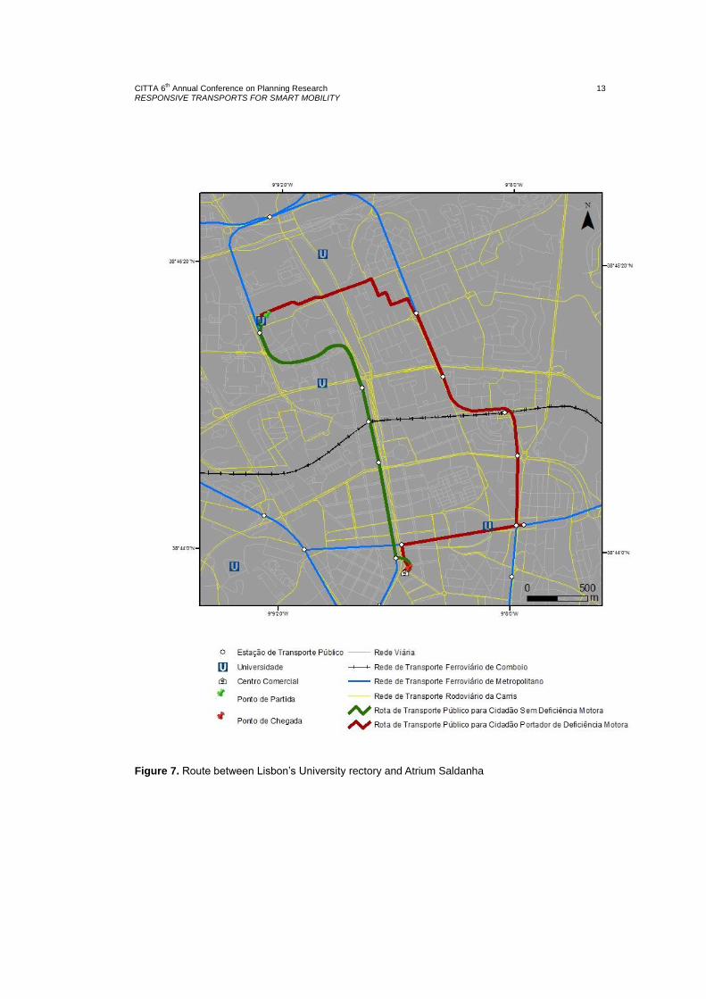
6.2 Best route determination
One of the interesting operations that can be done after modelling the network is to determine the
best routes using the Route option from Network Analyst (ArcGis). As an example it was
determined a route between two points of public interest using as departure point Lisbon’s
University rectory and the arrival one at Atrium Saldanha. The map showing the routes between
these two points (Figure 7) shows two different routes, one in green for a person with no disabilities
and that can go in the underground station of Cidade Universitária and out in Saldanha’s station,
going through about 3 km in 14 minutes (Table 5) on the other hand in red it’s represented the route
that has to be done by motor disabled people and the nearest underground station adapted to them
is Alvalade so a motor disabled person that wants to go from Cidade Universitária to Saldanha by
underground, should walk all the way to Alvalade’s station then swap the underground line in
Alameda’s station, between the green and yellow lines of Lisbon’s underground, what would
contribute to the amount of time spent on the journey, therefore going through between these two
points (Lisbon’s University rectory and Atrium Saldanha) 5,3 Km in 1 hour and 3 minutes (Table 5).
It is important do mention that this analysis on determining the best route doesn’t have in
consideration the road transports and in that account there could exist other routes if these ways of
transportation were considered in the network.
Table 5. Time and distances between the two points in both routes
Route Time Distance
Citizens wihtout motor desabilities 14 min. 3 Km
Citizens with motor desabilities 1h 3 min. 5,3 Km
CITTA 6th Annual Conference on Planning Research
RESPONSIVE TRANSPORTS FOR SMART MOBILITY 13
Figure 7. Route between Lisbon’s University rectory and Atrium Saldanha

P.MORAIS, R. GUERREIRO, N.M.COSTA “THE PUBLIC TRANSPORT AND THE MOBILITY OF MOTOR DISABLE
CITIZENS IN THE MUNICIPALITY OF LISBON”
14
6.3 Service proximity determination
Another interesting result was the determination of service proximity. The objective of this analysis
was to understand which reachable hospitals were in an hour for citizens with no disabilities and
citizens with motor disabilities starting from the same point (a residential area in Chelas as it can be
seen in Figures 10 and 11). To achieve this results it was used the tool Closest Facility from
Network Analyst (ArcGis). The results indicate which hospital units were reachable and the possible
routes within an hour from the same point of origin.
For the non-disabled citizens it is possible to reach 10 hospital units in an hour by public transports:
Hospital da CUF, Hospital Pulido Valente, Hospital de Santa Maria, Hospital Curry Cabral, the
Maternity Alfredo da Costa, Hospital de Santa Marta, Hospital de São José, Hospital Miguel
Bombarda, Hospital dos Lusíadas and Hospital da Cruz Vermelha (Figures 8 and 10).
Figure 8. Possible routes until one hour for reaching Hospital units – citizens with no disabilities
For the motor disabled citizens the results are quite different. In the same period of time only 7
hospital units are reachable, being out of the list the Hospital de Santa Maria, Hospital dos
Lusíadas and the Hospital da Cruz Vermelha (Figures 9 and 11).
Figure 9. Possible routes until one hour for reaching Hospital units – citizens with motor disabilities

CITTA 6th Annual Conference on Planning Research
RESPONSIVE TRANSPORTS FOR SMART MOBILITY 15
Figure 10. Service proximity – Route for citizens with no motor disabilities

P.MORAIS, R. GUERREIRO, N.M.COSTA “THE PUBLIC TRANSPORT AND THE MOBILITY OF MOTOR DISABLE
CITIZENS IN THE MUNICIPALITY OF LISBON”
16
Figure 11. Service proximity – Routes for motor disabled citizens.

CITTA 6th Annual Conference on Planning Research
RESPONSIVE TRANSPORTS FOR SMART MOBILITY 17
7 Conclusions
This work allowed to highlight the importance of using GIS for the study of transport and
accessibility. Modelling the network with variables related with offer of adapted services for citizens
with motor disabilities enabled to highlight and quantify the differences in mobility that these
services causefor those that depend of them.By conceptualizing this multimodal network it was
possible to do some exercises that allowed to show the abilities of this approach but it mainly
allowed to verify the existence of many barriers and difficulties that motor disabled citizens go
through nowadays in order to use public transports for going around their lives in a urban area like
Lisbon.
Another result was the understanding that it is urgent to adapt the oldest underground stations and
to increase the range of adapted buses. In order to enhance the service of public transports in
Lisbon it should be taken in account a better coordination between the different responsible entities
of these public transports so that there would be an arranged and reasonable response for the
motor disabled citizens. It is important to raise awareness for a more equal and sharing society in
which is important to alert for the difficulties that motor disabled people have and the right that all
people can have assured their access to public transports therefore contributing for a more
inclusive city and a healthier one.
References
Butler J A (2008) “Designing Geodatabases for Transportation”, ESRI, Redlands.
Costa N M (2007) “Mobilidade e Transporte em Áreas Urbanas - O caso da Área Metropolitana de Lisboa”.
Doctoral Dissertation, Department of Geography, Universidade de Lisboa, Lisbon.
Miller H J, Shih-Lung S (2001) “Geographic Information Systems for Transportation: principles and
applications”, Oxford University Press, Oxford.
Smith M J, Goodchild M F, Longley P A (2007) ”Geospatial Analysis. A Comprehensive Guide to Principles,
Techniques and Software Tools”, Whinchelsea Press, Leicester.