Chronology of the last glacial cycle in the European Alps · Geographic setting The European Alps...
15
Chronology of the last glacial cycle in the European Alps SUSAN IVY-OCHS, 1,2 * HANNS KERSCHNER, 3 ANNE REUTHER, 4 FRANK PREUSSER, 5 KLAUS HEINE, 6 MAX MAISCH, 2 PETER W. KUBIK 7 and CHRISTIAN SCHLU ¨ CHTER 5 1 Insitut fu ¨ r Teilchenphysik, ETH-Ho ¨ nggerberg, Zu ¨ rich, Switzerland 2 Geographisches Institut, Universita ¨t Zu ¨ rich-Irchel, Zu ¨ rich, Switzerland 3 Institut fu ¨ r Geographie, Universita ¨t Innsbruck, Innsbruck, Austria 4 Insitut fu ¨ r Physische Geographie, Universita ¨t Regensburg, Regensburg, Germany 5 Institut fu ¨ r Geologie, Universita ¨t Bern, Bern, Switzerland 6 Insitut fu ¨ r Physische Geographie, Universita ¨t Regensburg, Regensburg, Germany 7 Paul Scherrer Institut, c/o Institut fu ¨ r Teilchenphysik, ETH Ho ¨ nggerberg, Zu ¨ rich, Switzerland Ivy-Ochs, S., Kerschner, H., Reuther, A., Preusser, F., Heine, K., Maisch, M., Kubik, P. W. and Schlu ¨ chter, C. 2008. Chronology of the last glacial cycle in the European Alps. J. Quaternary Sci., Vol. 23 pp. 559–573. ISSN 0267-8179. Received 20 August 2007; Revised 18 April 2008; Accepted 1 May 2008 ABSTRACT: Chronological data for glacier advances in the European Alps between the Last Interglacial (Eemian) and the Holocene are summarised (115 to 11 ka). During this time glaciers were most extensive, extending tens of kilometres out onto the forelands, between 30 and 18 ka, that is, synchronous with the global ice volume maximum of Marine Isotope Stage (MIS) 2. Evidence for ice expanding to just past the mountain front for an earlier major glacier advance comes from Swiss sites, where advances have been luminescence dated to MIS 5d (100 ka) and MIS 4 (70 ka). Up to now no such evidence has been found in the Eastern Alps. By 18 ka, more than 80% of the Late Wu ¨ rmian ice volume had gone. Subsequently glaciers readvanced, reaching into the upper reaches of the main valleys during the Lateglacial Gschnitz stadial, which likely occurred around 17 ka, with final moraine stabilisation no later than 15.4 ka. The link of the Egesen stadial with the Younger Dryas climate deterioration is supported by exposure ages from four sites as well as minimum-limiting radiocarbon dates from bogs within former glacier tongue areas. Key questions on the spatial and temporal variability of ice extents throughout the last glacial cycle have yet to be answered. Copyright # 2008 John Wiley & Sons, Ltd. KEYWORDS: cosmogenic 10 Be; luminescence; Last Glacial Maximum; Wu ¨ rmian; Lateglacial. Introduction The landscape of the Alps bears witness to repeated glacial sculpting on a massive scale. Sediment was carved out of the mountains, carried downvalley by the glaciers and deposited far out onto the Alpine forelands (Fig. 1). Centuries before Agassiz published his ‘E ´ tudes sur les Glaciers’ (Agassiz, 1840) the local people were familiar not only with advancing glaciers but with the notion that glaciers had been vastly larger in the past. Beginning already in the early 1800s, glaciers, moraines and outwash as well as glacially scoured bedrock features were studied and mapped in detail (Venetz, 1833; Agassiz, 1840; de Charpentier, 1841). Penck and Bru ¨ ckner (1901/09) developed the well-known fourfold Alpine glacial chronology (from oldest to youngest): Gu ¨nz, Mindel, Riss and Wu ¨rm, based on their mapping results both on the forelands and in the Alps. Since that time detailed studies on the terrestrial record of Quaternary glaciations have led to the conclusion that there have been many more than four glaciations during which the glaciers extended out of the Alps and onto the forelands (summaries in Fiebig et al., 2004; Preusser, 2004; Schlu ¨ chter, 2004; van Husen, 2004). The record for the Swiss Alps indicates at least 15 independent glaciations (Schlu ¨ chter, 2004). In this paper we provide a brief overview of the existing chronological data, especially cosmogenic nuclide surface exposure, luminescence and radiocarbon ages, for glaciations of the Alps during the last glacial cycle. The basis of the chronological data is more than a hundred years of detailed field research. In the Alps, the last glacial cycle (Wu ¨ rmian) covers the time from the end of the Last Interglacial (Eemian ¼ Marine Isotope Stage (MIS) 5e) to the beginning of the Holocene. The Wu ¨ rmian glaciation has been subdivided into Early, Middle and Late Wu ¨ rmian (Chaline and Jerz, 1984). Reflecting the regional distribution of the available chrono- logical data we focus on the northern regions of the Alps and their forelands (Austria, Germany and especially Switzerland). JOURNAL OF QUATERNARY SCIENCE (2008) 23(6-7) 559–573 Copyright ß 2008 John Wiley & Sons, Ltd. Published online in Wiley InterScience (www.interscience.wiley.com) DOI: 10.1002/jqs.1202 * Correspondence to: S. Ivy-Ochs, Insitut fu ¨ r Teilchenphysik, ETH-Ho ¨ nggerberg 8093 Zu ¨ rich, Switzerland. E-mail: [email protected]
Transcript of Chronology of the last glacial cycle in the European Alps · Geographic setting The European Alps...

Chronology of the last glacial cycle in theEuropean AlpsSUSAN IVY-OCHS,1,2* HANNS KERSCHNER,3 ANNE REUTHER,4 FRANK PREUSSER,5 KLAUS HEINE,6 MAX MAISCH,2
PETER W. KUBIK7 and CHRISTIAN SCHLUCHTER51 Insitut fur Teilchenphysik, ETH-Honggerberg, Zurich, Switzerland2 Geographisches Institut, Universitat Zurich-Irchel, Zurich, Switzerland3 Institut fur Geographie, Universitat Innsbruck, Innsbruck, Austria4 Insitut fur Physische Geographie, Universitat Regensburg, Regensburg, Germany5 Institut fur Geologie, Universitat Bern, Bern, Switzerland6 Insitut fur Physische Geographie, Universitat Regensburg, Regensburg, Germany7 Paul Scherrer Institut, c/o Institut fur Teilchenphysik, ETH Honggerberg, Zurich, Switzerland
Ivy-Ochs, S., Kerschner, H., Reuther, A., Preusser, F., Heine, K., Maisch, M., Kubik, P. W. and Schluchter, C. 2008. Chronology of the last glacial cycle in the EuropeanAlps. J. Quaternary Sci., Vol. 23 pp. 559–573. ISSN 0267-8179.
Received 20 August 2007; Revised 18 April 2008; Accepted 1 May 2008
ABSTRACT: Chronological data for glacier advances in the European Alps between the LastInterglacial (Eemian) and the Holocene are summarised (115 to 11 ka). During this time glaciersweremost extensive, extending tens of kilometres out onto the forelands, between 30 and 18 ka, that is,synchronous with the global ice volume maximum of Marine Isotope Stage (MIS) 2. Evidence for iceexpanding to just past the mountain front for an earlier major glacier advance comes from Swiss sites,where advances have been luminescence dated to MIS 5d (100 ka) and MIS 4 (70 ka). Up to now nosuch evidence has been found in the Eastern Alps. By 18 ka, more than 80% of the Late Wurmian icevolume had gone. Subsequently glaciers readvanced, reaching into the upper reaches of the mainvalleys during the Lateglacial Gschnitz stadial, which likely occurred around 17 ka, with final morainestabilisation no later than 15.4 ka. The link of the Egesen stadial with the Younger Dryas climatedeterioration is supported by exposure ages from four sites as well as minimum-limiting radiocarbondates from bogs within former glacier tongue areas. Key questions on the spatial and temporalvariability of ice extents throughout the last glacial cycle have yet to be answered. Copyright # 2008John Wiley & Sons, Ltd.
KEYWORDS: cosmogenic 10Be; luminescence; Last Glacial Maximum; Wurmian; Lateglacial.
Introduction
The landscape of the Alps bears witness to repeated glacialsculpting on a massive scale. Sediment was carved out of themountains, carried downvalley by the glaciers and depositedfar out onto the Alpine forelands (Fig. 1). Centuries beforeAgassiz published his ‘Etudes sur les Glaciers’ (Agassiz, 1840)the local people were familiar not only with advancing glaciersbut with the notion that glaciers had been vastly larger in thepast. Beginning already in the early 1800s, glaciers, morainesand outwash as well as glacially scoured bedrock features werestudied and mapped in detail (Venetz, 1833; Agassiz, 1840; deCharpentier, 1841). Penck and Bruckner (1901/09) developedthe well-known fourfold Alpine glacial chronology (from oldestto youngest): Gunz, Mindel, Riss and Wurm, based on their
mapping results both on the forelands and in the Alps. Sincethat time detailed studies on the terrestrial record of Quaternaryglaciations have led to the conclusion that there have beenmany more than four glaciations during which the glaciersextended out of the Alps and onto the forelands (summaries inFiebig et al., 2004; Preusser, 2004; Schluchter, 2004; vanHusen, 2004). The record for the Swiss Alps indicates at least 15independent glaciations (Schluchter, 2004).In this paper we provide a brief overview of the existing
chronological data, especially cosmogenic nuclide surfaceexposure, luminescence and radiocarbon ages, for glaciationsof the Alps during the last glacial cycle. The basis of thechronological data is more than a hundred years of detailedfield research. In the Alps, the last glacial cycle (Wurmian)covers the time from the end of the Last Interglacial(Eemian¼Marine Isotope Stage (MIS) 5e) to the beginning ofthe Holocene. The Wurmian glaciation has been subdividedinto Early, Middle and Late Wurmian (Chaline and Jerz, 1984).Reflecting the regional distribution of the available chrono-logical data we focus on the northern regions of the Alps andtheir forelands (Austria, Germany and especially Switzerland).
JOURNAL OF QUATERNARY SCIENCE (2008) 23(6-7) 559–573Copyright � 2008 John Wiley & Sons, Ltd.Published online in Wiley InterScience(www.interscience.wiley.com) DOI: 10.1002/jqs.1202
*Correspondence to: S. Ivy-Ochs, Insitut fur Teilchenphysik, ETH-Honggerberg8093 Zurich, Switzerland.E-mail: [email protected]

Geographic setting
The European Alps are situated close to the southern fringe ofthe European mainland. From the Mediterranean coastbetween the Rhone delta in France and Genoa in Italy, theytrend northwards towards the Mont Blanc massif. There, theybend in an easterly direction. The main body of the Alpsbetween Valence (France) and Vienna (Austria) is about 950 kmlong. Between 108 and 128 E latitude in the Tyrol region (Austriaand Italy), the Alps reach their largest N–S extent of roughly300 km. Wide structurally controlled longitudinal valleys(Rhone, Rhein, Inn) and intramontane basins are frequent.The highest peaks, well above 4000m above sea level(a.s.l.), are situated in western Switzerland and neighbouringsoutheastern France (highest peak of the Alps: Mt Blanc,4809m a.s.l.). There, mountain passes are generally above2000m a.s.l. Further east, the characteristic altitude remainsgenerally below 2000m a.s.l., with the highest peaks reachingaround 3000m a.s.l.Presently, the Alps are exposed to the westerlies, which are
an important source of moisture coming in from the NorthAtlantic Ocean. They cause high precipitation sums along thenorthern and western fringe of the Alps. Lee cyclogenesis in theGulf of Genoa plays an important role for precipitationextremes in the Southern and Eastern Alps. Winter precipitationshows a clear dependency on the orography with well-developed stau and lee situations relative to the dominantairflow. In summer very low pressure gradients over continentalEurope are frequent and orographically induced convectiveprecipitation plays an important role. Annual precipitationsums along the northern and southern fringe are rather similar,but due to the topographic barriers in the north and south theinner Alpine valleys are usually rather dry (Fliri, 1974; Frei andSchar, 1998). As the Alps are a mid-latitude mountain chain, airtemperatures are presently rather mild and usually similar tothose from sites outside the Alps at similar altitudes. Summertemperatures at the equilibrium line altitude (ELA) of the Alpineglaciers are usually positive, and hence most of the Alpine
glaciers are temperate glaciers. Winter temperatures generallydecrease eastwards, as cold air spells from eastern Europe(related to the strength of the Siberian High) are more frequentin eastern Austria.
Methods
Fundamental understanding of the glaciations of the Alps isbased on detailed mapping and therefore interpretation ofmorpho- and lithostratigraphic field relationships. This allowedconstruction of a relative temporal framework. Since theirdevelopment, radiocarbon, surface exposure, U/Th dating andluminescence methods have been used to provide chrono-logical constraints. Each method has its important niche basedon material that can be dated and on applicable time ranges(cf. Preusser, 2004; Ivy-Ochs et al., 2006b).
Since 1991, numerous bedrock and boulder surfaces in theAlps have been dated with surface exposure dating withcosmogenic 10Be, 21Ne, 26Al and 36Cl (Ivy-Ochs, 1996; Ivy-Ochset al., 1996, 2004, 2006a,b; Kelly et al., 2004b, 2006). Here,we focus on 10Be data (half-life used 1510 ka). To calculateexposure ages we have used a 10Be production rate of 5.1� 0.3atoms 10Be g�1 SiO2 a
�1 (with 2.2% production due to muons),and scaling to the site location based on Stone (2000). Ageshave been corrected for erosion, snow and/or vegetation coveron a site-by-site basis as discussed in Ivy-Ochs et al. (2006b),Kelly et al. (2006) and Reuther (2007). We have used anexponential model depth profile and an attenuation length of157 g cm�2. No correction has been made for changes inmagnetic field intensity over the exposure period (Masariket al., 2001). The errors given for individual boulder ages reflectanalytical uncertainties (dominated by accelerator mass spec-trometry measurement parameters). Average landform ages includeuncertainties in the 10Be production rate, but do not includeuncertainties in the scaling to the site (cf. Gosse and Phillips,2001). We include the recent data from the Isar–Loisach
Figure 1 Reference map for site locations discussed in the text. The Alps are shown as a stippled pattern. The extent of ice during the Last GlacialMaximum (based on Ehlers and Gibbard, 2004) is indicated by the shaded area inside the bold line
Copyright � 2008 John Wiley & Sons, Ltd. J. Quaternary Sci., Vol. 23(6-7) 559–573 (2008)DOI: 10.1002/jqs
560 JOURNAL OF QUATERNARY SCIENCE

Glacier LateWurmian site (Reuther, 2007). In addition, the dataof Kelly et al. (2004b) for the Great Aletsch Glacier site havebeen recalculated using the production rate and scaling ofStone (2000).The application of luminescence methods for dating deposits
directly related to Alpine glaciations is limited to not muchmore than about a dozen sites. Owing to the limited suitabilityof most quartz in the area (Preusser, 1999a) most of thesestudies have used K-feldspar as natural dosimeter. While thefirst studies were carried out using the multiple-aliquot additivedose (MAA) procedure,more recently the single-aliquot regene-rative dose (SAR) protocol has been applied, both using infraredstimulated luminescence (IRSL). In contrast to some other areas,K-feldspars from the Alps are apparently not affected byanomalous fading of the IRSL signal. This has been proven byboth experimental evidence (Preusser, 1999a; Visocekas andGuerin, 2006) as well as by comparison of IRSL ages withindependent age control (Preusser, 1999b, 2003; Preusseret al., 2003). A more recent study has demonstrated thesuitability of SAR quartz methodology in sediments on theforeland of the Swiss Alps (Preusser et al., 2007) but this mineralis apparently affected by important methodological problems inthe Bavarian Alpine foreland, making it virtually unsuitable forluminescence dating (Klasen, 2007).For brevity in this paper we only discuss radiocarbon dates
that we consider are key with respect to interpretations ofglacier variations and have unambiguous stratigraphic relation-ships. Uncalibrated radiocarbon dates are indicated by 14C aBP and calibrated dates by cal. a BP. Radiocarbon dates whichcorrespond to 26 cal. ka BP or less have been calibrated usingOxCal 4.0 (Bronk Ramsey, 2001) with the IntCal04 data set(Reimer et al., 2004). For older dates we have used the datasetof Hughen et al. (2006) to obtain an estimate of calendar dates;the term ‘cal.’ is not used. Use of other datasets will result insomewhat different calibrated ages. Specific site locations forthe radiocarbon dates as well as laboratory numbers are foundin the original references.As a standard in the Alps, equilibrium line altitudes are
calculated with an accumulation area ratio (AAR) of 0.67 fromcontour line maps of the reconstructed Lateglacial palaeogla-ciers. This works well under most Alpine conditions, becausethe method was originally calibrated with a large sample ofglaciers from the European Alps (Gross et al., 1977; Maisch,1992). However, under colder and drier conditions, slightlylarger AARs (0.70–0.75, e.g. White Glacier on Axel HeibergIsland, Canada; Cogley et al., 1996) could bemore appropriate,because in such cases mass balance gradients are smaller andmass turnover is reduced. ELA depressions are given relative tothe average Little Ice Age (LIA) ELA of the individual glacier’scatchment, which can be determined more reliably than a‘present-day’ ELA (Gross et al., 1977). Palaeoglaciological(Maisch and Haeberli, 1982) and palaeoclimatic (Kerschnerand Ivy-Ochs, 2008) interpretation of the former glaciertopographies provides some insight into the climatic conditionsduring the Lateglacial stadials.
The last glacial cycle in the Alps
Early and Middle Wurmian
During the glaciation (‘Rissian’ in classical terms) whichpreceded the Last Interglacial (Eemian), the pre-existing,partially filled Alpine foreland basins were excavated anddeepened. They were subsequently filled with sediment where
environmental conditions during the Wurmian are recorded,especially vegetation dynamics in the surroundings of the lakesby means of fossil pollen. While most of these foreland basinarchives such as Durnten (Welten, 1982), Furamoos (Mulleret al., 2003), Gondiswil (Wegmuller, 1992), Les Echetes (deBeaulieu and Reille, 1994), Mondsee (Drescher-Schneider,2000), Samerberg (Gruger, 1979) and Wurzach (Gruger andSchreiner, 1993) show a well-developed EarlyWurmian record(equivalent to MIS 5), the Middle Wurmian is usually poorlypreserved and information is restricted to a few sites. Althoughdirect dating evidence is limited to a few U/Th datings of peatand some luminescence ages, the correlations indicated beloware mainly accepted (Fig. 2) (cf. Preusser, 2004).The equivalent of MIS 5e (Eemian) around the Alps is
reflected by interglacial conditions with broadleaf deciduousforests followed by a harsh climatic deterioration duringMIS 5d(1. Stadial). This led, at least in the northern Alps, to a completecollapse of vegetation, leaving only steppe to tundra-likeenvironments (Welten, 1981). This first cold period wasfollowed by a temperate phase with boreal forest (Picea, Pinusand some deciduous trees: 1. Interstadial), a second but lesspronounced cold phase (2. Stadial) and a second temperatephase (2. Interstadial), which represents environmental con-ditions similar to those of the 1. Interstadial. Glacier extensionduring the Early Wurmian is poorly constrained and remainscontroversial. In the Eastern Alps, evidence from the areaaround Hopfgarten implies that glaciers most likely did notreach into the main Alpine valleys during the two cold stages ofthe Early Wurmian (Reitner, 2005, 2007). This is supported byU-series dates on calcite flowstones implying that the InnValley was ice-free between 102 and 70 ka (MIS 5c to 5a) (Spotland Mangini, 2006). In contrast, dating evidence from two sitesclose to the margin of the Swiss Alps (Gossau: Preusser et al.,2003; Thalgut: Preusser and Schluchter, 2004) indicates thatglaciers probably extended onto the foreland during MIS 5d. AtGossau, a suite of 42 luminescence ages (MAA K-feldspar,polymineral fine grains, quartz) yields a mean age of103� 13 ka for this advance (Preusser et al., 2003).By the definition of the Subcommission on European
Quaternary Stratigraphy (SEQS) the end of the 2. WurmianInterstadial at the Samerberg site marks the transition from theEarly to the Middle Wurmian (Chaline and Jerz, 1984). This
Figure 2 Time–distance diagram for the last glacial cycle in the SwissAlps and foreland (modified from Preusser and Schluchter, 2004).Position and timing of the Late Wurmian maximum are well known,while possible earlier glacier advances are at present poorly con-strained, as indicated by the question marks (cf. Preusser, 2004). Inthe Austrian sector no clear-cut evidence has been found for advancesreaching the main valleys between the Eemian Interglacial and the LateWurmian (van Husen, 2000, 2004; Reitner, 2005). Marine IsotopeStage boundaries from Martinson et al. (1987) and Shackleton et al.(2002). For a detailed view of the Lateglacial stadials see Fig. 5
Copyright � 2008 John Wiley & Sons, Ltd. J. Quaternary Sci., Vol. 23(6-7) 559–573 (2008)DOI: 10.1002/jqs
CHRONOLOGY OF THE LAST GLACIAL CYCLE IN THE EUROPEAN ALPS 561

transition is usually set to the boundary MIS 5/4 (see Preusser,2004, for discussion). Tundra-like environments after the 2.Interstadial are accordingly interpreted to reflect cold con-ditions during MIS 4. The following Interstadial (3. Interstadialtermed Durnten), which is less temperate than its predecessors,most likely reflects earliest MIS 3 (Welten, 1981; Chaline andJerz, 1984;Wegmuller et al., 2002; Preusser, 2004). This periodis characterised by open boreal forests and relatively temperateconditions (Welten, 1982). Relatively warm climatic con-ditions during early MIS 3 have also been identified inspeleothem records from the Inn Valley area (Spotl andMangini, 2002).Similar to the Early Wurmian cold phases, in particular MIS
5d, there is controversial discussion about glacier extentsduring MIS 4. While in the Eastern Alps no evidence for thepresence of glaciers in the main Alpine valleys has been found(van Husen, 2000; Reitner, 2005), an important glaciationreaching the lowlands of theWestern Alps duringMIS 4 has beenlargely accepted (Welten, 1982; Frenzel, 1991; Schluchter,1991; Keller and Krayss, 1998). Direct dating of associateddeposits is limited to two key studies. In western Switzerland(Finsterhennen), proglacial outwash underlying a residual(weathered) till has been dated by SAR–optically stimulatedluminescence (OSL) (quartz) to ca. 70 ka (Preusser et al., 2007).The glaciofluvial sediments on top of the till are dated tobetween 30 and 25 ka and hence represent the last glaciation(Late Wurm) of the Alps (see below). In the Kempten Basin (SWBavaria), three phases of lake formation have been identified,which are interpreted to reflect glacial advances into the area(Link and Preusser, 2006).While the youngest of these phases isdated toMIS 2 and the oldest is of pre-Wurmian age, the middlephase has been dated by luminescence to MIS 3/4. Furtherdating evidence supporting early to middle Late Pleistoceneglacial advances is to some extent given by luminescencedating of braided-river terrace deposits from several sites inboth northern Switzerland (Preusser and Graf, 2002) andBavaria (Ingolstadt; Fiebig and Preusser, 2003) (see alsoPreusser, 2004). However, the presence of braided rivers inthe Alpine foreland for a given time does not directly allow anyconclusion about the presence of glaciers in the catchment ofthese rivers, as the response of rivers to environmentalcondition is rather complex. Braided river systems may wellbecome established without any direct glacial influence.Multi-dating (radiocarbon, U/Th, luminescence) evidence
from the Gossau site (Fig. 1) clearly illustrates that the lowlandsof Switzerland were ice-free during all of MIS 3 (Schluchteret al., 1987; Preusser et al., 2003). Apparently environmentalconditions were unstable but remained mainly cool to weaklytemperate. Maximum summer temperatures of up to �138Chave been estimated based on fossil beetle assemblages (Jost-Stauffer et al., 2001, 2005; Coope, 2007). A weakly developedinterstadial duringmidMIS 3 has been dated to ca. 45 ka at bothGossau as well as Niederweningen and this period is charac-terised by the expansion of open Picea forest (Drescher-Schneider et al., 2007; Hajdas et al., 2007; Preusser andDegering, 2007). The end of MIS 3 (¼ Middle Wurmian) hasbeen defined by SEQS at Baumkirchen (Fig. 1) (Chaline andJerz, 1984). At this site, laminated silty lake deposits areoverlain by till attributed to the last glaciation. Wood fragmentsgathered from the silty lake deposits have been dated tobetween 26 and 31 14C ka BP (Fliri et al., 1970; Fliri, 1973).Recently obtained luminescence ages, ca. 35 and 45 ka, areslightly higher, even in light of the fact that the radiocarbon agesare uncalibrated (Klasen et al., 2007). If the luminescence agesare correct, the site would actually not represent the latest partof MIS 3. In any case, it is clear that glaciers were absent in theInn Valley during (at least most of) MIS 3.
Late Wurmian
Data from several sites show that Alpine glaciers had nearlyreached the mountain front by 30 ka. This is impressivelydemonstrated at several sites where outwash deposits overliepeat, dated to about 30 ka (cf. Schluchter et al., 1987;Schoeneich, 1998; Preusser, 2004). During the Late Wurmian,large valley glaciers formed as glaciers flowed out of the mainaccumulation areas and ice domes in the high Alps (Florineth,1998; Florineth and Schluchter, 1998; Kelly et al., 2004a).Upon reaching the lowlands, the glaciers spread out into broad,often coalescing, piedmont lobes (Penck and Bruckner, 1901/1909). Steep-walled moraines, broad ridges, as well ashummocky ground found over several to in some cases tensof kilometres, comprise the terminal landforms of the piedmontglaciers. The ELA depression associated with the Late Wurmianglaciers with respect to the LIA ELA was around 1200–1500m(Haeberli, 1991; van Husen, 1977, 1997; Keller and Krayss,2005a) (Table 1). Here we summarise (from west to east) keychronological data for the most important piedmont lobes(Fig. 1), which are generally representative for the northernforelands.
Rhone Glacier
As the LateWurmian Rhone Glacier extended onto the forelandit split into a southern (Geneva) and northern (Solothurn) lobe.A mammoth tusk recovered from fluvioglacial gravel depositedin front of the advancing Rhone glacier yielded an age of 25370� 190 14C a BP (Finsterhennen; Schluchter, 2004) (30.2–28.5 ka). Recent luminescence dating of sediment from theFinsterhennen site provides a similar age (Preusser et al., 2007).The Rhone Glacier reached its maximum position in the regionof Wangen an der Aare, where broad, indistinct moraines markthe former icemargin. The 10Be ages from four boulders locatedon a broad ridge of the outermost right lateral moraine justinside a major meltwater drainage system (Fig. 3) range from17.1 to 20.9 ka (Ivy-Ochs et al., 2004, 2006b). The ages of20.8� 1.3 and 20.9� 0.9 ka mark the beginning of morainestabilisation. By 19.6� 1.3 ka the terminal moraines had beencompletely abandoned by the Rhone glacier. The youngest age(17.1� 1.2 ka) reflects post-depositional processes such asspalling or toppling of the boulder associated with prolongedmoraine instability (see also below). Upstream of the Wangensite, on the northern end of Lac de Neuchatel, pollen andmacrofossil data indicate that the lake basin became free of iceduring the earliest phase of the Oldest Dryas (Hadorn et al.,2002; Magny et al., 2003). There, the oldest radiocarbon date is14 250� 95 14C a BP (16 800–17 400 cal. a) (Hauterive/Rouges-Terres; Hadorn et al., 2002).
Rhein Glacier
The foreland piedmont Rhein Glacier was comprised of theLinth/Rhein lobe in the west and the Rhein Glacier in theBodensee region. The Linth/Rhein piedmont lobe was fed byboth the Linth Glacier originating in the Glarnisch region andthe Walensee arm of the Rhein Glacier (Penck and Bruckner,1901/1909). Data from the Gossau site (Fig. 1), whereradiocarbon ages (Schluchter et al., 1987) are verified by bothU/Th (Geyh et al., 1997) as well as several luminescence ages(Preusser et al., 2003), indicate that the Linth/Rhein Glacierreached this site, which is some 30 km from the margin of the
Copyright � 2008 John Wiley & Sons, Ltd. J. Quaternary Sci., Vol. 23(6-7) 559–573 (2008)DOI: 10.1002/jqs
562 JOURNAL OF QUATERNARY SCIENCE

Tab
le1
SummaryofLa
stGlacial
Maxim
um
toLa
teglac
ialglac
ierva
riationsin
thenorthernEu
ropea
nAlps(m
odified
from
Ivy-Och
set
al.,2006b)
Stad
ial
Morainean
dglac
ierch
arac
teristics
Reg
ional
situation
ELAdep
ressionve
rsusLIAEL
ATim
e-stratigrap
hic
position
10Beag
es(ka):site
Kartell
Well-defi
ned
,block
y,multiple
moraine
ridge
s,sm
allrock
glac
iers
Cirquean
dva
lley
glaciers,clearly
larger
than
LIA,butsm
allerthan
innermostEg
esen
phase
�120m
attypeloca
lity
Preboreal
oscillation?
10.8�1.0:Kartellcirque
Egesen
Sharp-crested
,often
block-rich,multiple
moraineridge
swell
docu
men
tedin
widearea
softheAlps.Three-phased
read
vance
ofva
lley
glac
iers
andcirqueglaciers
Developmen
tofex
tensive
rock
glaciersystem
sduring
laterpartsofthestad
ial
Cirquean
dva
lley
glaciers,ve
ryfew
den
driticglaciers
�450to
�180m
forthe
max
imum
adva
nce
,dep
endingonloca
tion
Younge
rDryas
12.3�1.5:Julier
Pass,outer
11.3�0.9:Julier
Pass,inner
12.2�1.0:Sc
honferw
all
11.2�1.1:Aletsch
a
11.2�0.9:Val
Viola
b
Dau
nW
ell-defi
ned
butsm
oothed
moraines,relative
lyfew
boulders,
solifluctionove
rprintduringYD
(Egesen);moraines
usually
missingin
more
oce
anic
area
softheAlps(ove
rrunbyEg
esen
?).
Smallerthan
Clavadel/Sen
ders
Glaciersslightlylarger
than
loca
lEg
esen
glac
iers
��400to
�250m
dep
endingonloca
tion
Before
Bølling
Clavadel/Se
nders
Welldefi
ned
,often
sedim
ent-rich
moraines
Cirquean
dva
lley
glaciers,some
den
driticglaciers
stillintact
��400to
�500m
dep
endingonloca
tion
Before
Bølling
Clearly
smallerthan
‘Gschnitz’
Gschnitz
Steep-w
alled,somew
hat
block
y,largesinglemoraines,no
solifluctionove
rprintbelow
1400m
Man
yva
lley
glac
iers,somelarge
den
driticglaciers
stillintact
��650to
�700m
Before
Bølling
>15.4�1.4:Gschnitzva
lley
Widespread
read
vance
oflargeva
lley
glac
iers
onatimesca
leofseve
ralce
nturies
Phaseofea
rly
Lateglac
ialicedecay
Gen
eral
downwastingan
drece
ssionofpiedmontglac
iers
intheforelandwithsomeoscillationsoftheglaciermargins.c,d,e
Mainly
icemarginal
dep
osits;moraines
indicating
glacierad
vance
insm
allerca
tchmen
ts.cGlacial
adva
nce
salso
dueto
ice-mec
han
ical
causes.bComprisestheclassica
l‘Buhl’an
d‘Steinach’stad
ials
Downwastingden
driticglac
iers,
increa
singnumber
ofloca
lglaciers
Largelyundefi
ned
,betwee
n�LG
Man
d�8
00m
Before
Bølling,
older
than
15400�470
14CaBP
(18020–1
9010ca
l.aBP)
LGM
Chainsofterm
inal
moraines
from
theoften
coalescing
piedmontlobes;often
possible
tosubdivideinto
threephases
d,e
Icedomes
inthehighAlps,outlet
glac
iers,piedmontglac
iers
onthe
forelands
�1200to
�1500m
Final
deg
laciation
20.9�1.5:W
angen
Forco
mplete
referencesseeIvy-Och
set
al.(2006b).Additional
references:
aKelly
etal.(2004b).
bHorm
eset
al.(2008).
cReitner
(2005,2007).
dKelleran
dKrayss(2005a,b).
eva
nHusen(1977,1997,2000).Site
loca
tionsshownin
Fig.
1.
Copyright � 2008 John Wiley & Sons, Ltd. J. Quaternary Sci., Vol. 23(6-7) 559–573 (2008)DOI: 10.1002/jqs
CHRONOLOGY OF THE LAST GLACIAL CYCLE IN THE EUROPEAN ALPS 563

Table 2 Cosmogenic nuclide concentrations and calculated exposure ages for the Isar–Loisach and Inn piedmont glaciers
Boulder no. Glacier Latitude Longitude Alt.(m a.s.l.)
Thick.(cm)
Shield.corr.
104 atomsg�1
Exposureage (a)
Corrected exposureagea (a)
AVS-03-01 Isar–Loisach 47.975 11.421 670 5.6 0.997 14.99�0.78 16 890� 790 17 590� 830AVS-03-03 Isar–Loisach 47.995 11.390 656 5.5 0.997 14.74�0.66 16 660� 680 17 340� 710AVS-03-04 Isar–Loisach 47.950 11.392 659 4.5 0.996 12.95�1.02 14 640� 1060 15 250� 1100AVS-03-05 Isar–Loisach 47.987 11.400 645 4.5 1.000 32.43�0.97 37 040� 880 38 920� 920AVS-03-06 Isar–Loisach 47.986 11.401 650 5.0 1.000 13.71�0.77 15 580� 790 16 220� 830AVS-03-09 Isar–Loisach 48.000 11.375 625 5.5 1.000 11.04�0.51 12 640� 540 13 170� 560AVS-03-10 Isar–Loisach 48.018 11.400 650 4.5 0.999 10.03�0.50 11 350� 530 11 840� 550AVS-03-11 Isar–Loisach 48.021 11.399 655 5.0 0.987 12.52�0.70 14 350� 740 14 950� 770AVS-03-12 Isar–Loisach 48.034 11.387 645 4.0 0.926 8.04�0.80 9800� 910 10 250� 960AVS-03-22 Isar–Loisach 47.986 11.403 685 5.5 0.994 13.02�0.74 14 510� 760 15 110� 790AVC-04-01 Inn 47.810 11.934 495 4.5 1.000 11.87�0.72 15 370� 850 16 010� 890
a Erosion-, snow- and vegetation-corrected exposure ages (for details see Reuther, 2007). Boulder locations shown in Fig. 4.
Figure 3 Digital elevation model based on DHM25 dataset (reproduced by permission of swisstopo� (JA082267)) for the region of the terminalmoraines of the northern lobe of the Rhone Glacier (figure modified from Ivy-Ochs et al., 2006b). Locations and 10Be ages of sampled boulders areshown. Vertical exaggeration is three times. Darker shading shows higher elevations. Scale varies with perspective
Figure 4 Relief of the moraine complex surrounding the Wurmsee (Isar-Loisach Glacier) with boulder locations and 10Be exposure ages. Darkershading shows higher elevations. Themoraines are represented by the darker shaded ridges. The digital elevationmodel is interpolated from the 1:5000topographic map (five times exaggerated). Scale varies with perspective. For reference, the distance between Leutstetten and the lakeshore isapproximately 4 km
Copyright � 2008 John Wiley & Sons, Ltd. J. Quaternary Sci., Vol. 23(6-7) 559–573 (2008)DOI: 10.1002/jqs
564 JOURNAL OF QUATERNARY SCIENCE

Alps, after 32 ka ago. Further out on the foreland, based onradiocarbon ages from the Zurichberg site the Linth/RheinGlacier reached its maximum extent near the village ofKillwangen (10 km north-west of Zurich) and receded to theSchlieren stadial position between 28 060� 340 14C a BP(32.1–32.9 ka) and 19 820� 190 14C a BP (23 450–24 010 cal.a BP) (Schluchter and Rothlisberger, 1995), after which itdownwasted with a marked stillstand at the Zurich stadialposition (Schindler, 2004; Keller and Krayss, 2005a). Althoughmuch of the terminal landforms have been removed by theLimmat River, spectacular lateral moraines, several tens ofmetres high, of the Zurich stadial line the shores of Lake Zurich.Complete deglaciation is marked by the end of meltwaterinfluence on d18O as determined from Lake Zurich sedimentwhich occurred before 14 600� 250 14C a BP (Lister, 1988)(17130–18030 cal. a BP).In the region of Bodensee, the Rhein Glacier spread out into a
broad piedmont lobe extending to just past the Schaffhausenregion at its maximum extent. The pattern of sub-parallel sets ofterminal moraines connected to extensive outwash plains andan intricate network of meltwater channels allowed subdivisioninto three main stadials (Schaffhausen, Stein am Rhein,Konstanz) (Keller and Krayss, 2005b). A date of 24 910�215 14C a BP (Ingoldingen; Schreiner, 1992) (29.6–30.2 ka) wasobtained from a mammoth tusk found underlying the lower-most till of the Late Wurmian advance. Radiocarbon datesobtained on mammoth bone fragments in proximal outwash atHuntwangen (Fig. 1) are 18 240� 130 14C a BP (21 180–22 130cal. a BP), 21 510� 160 14C a BP (25.2–26.1 ka) and 22190� 170 14C a BP (26.2–27.4 ka). Recent OSL dates from thatsite are in accordance with these ages (Preusser et al., 2007).Based on lithostratigraphy and correlation with the Lake Zurichcores, Wessels (1998) concluded that Bodensee was com-pletely free of ice by 17.5 to 18 ka.
Isar–Loisach Glacier
The Isar–Loisach Glacier originated from local glaciers in theNorthern Calcareous Alps but was supplemented substantiallyby ice transfluence from the Inn Valley (shown also by theprevalence of central Alpine clasts in the deposits) (Reuther,2007, and references therein). Thick outwash gravel depositsfrom the Isar–Loisach as well as from the Inn Glacier form theMunich gravel plain (Jerz, 1993), which is the type area for theWurmian glaciation of the Alps (Penck and Bruckner, 1901/1909). Sets of arcuate terminal moraine ridges are found alongthe margins of the lake basins of Wurmsee and Ammersee(Feldmann, 1992; Jerz, 1993). The ridges are in parts wellpreserved but disrupted by numerous kettle holes, which todayare filled with fens or seasonal kettle ponds (Jerz, 1987a,b). Themoraines are steep-walled, up to 40m high and severalhundred metres wide. The ten most suitable erratic bouldersfrom the terminal moraine complex were sampled (for detaileddiscussion see Reuther, 2007). The 10Be exposure ages of theboulders range from 10.3 to 38.9 ka (Table 2). Boulders AVS-03-05 and AVS-03-06 are locatedwithin only 20m on the samemoraine ridge (Fig. 4). Nevertheless, boulder AVS-03-05 yieldsan age (38.9� 0.9 ka) which is more than double the age of theboulder AVS-03-06 (16.2� 0.8 ka). This anomalously oldexposure age likely reflects pre-exposure. The boulder maypossibly have been reworked from deposits of an older advance(Reuther, 2007). The exposure age of the boulder (AVS-03-12)(10.3� 1.0 ka) located in a meltwater channel just distal to theLate Wurmian moraines is significantly younger than the otherboulders. The boulder likely fell into the channel after morainestabilisation. Two boulders (AVS-03-09, AVS-03-10) showed
obvious chip marks at the sides but not on the top where theywere sampled. The notably younger exposure ages (13.2�0.6 ka, 11.8� 0.6 ka, respectively) of these two boulders likelyreflect human impact. Overall the distribution of boulder agesdoes not show any clear relationship with respect to location onthe moraines in light of the former ice margin. Disregarding theage of AVS-03-05 (due to pre-exposure), the oldest ages wereobtained on boulder AVS-03-01 (17.6� 0.8 ka) on the crest ofthe outer moraine ridge and on boulder AVS-03-03 (17.3�0.7 ka) on the crest of the inner moraine ridge (Fig. 4). Theseboulders (AVS-03-01, AVS-03-03) are located right on top ofwell-preserved ridges which likely were some of the first tostabilise. The fact that these ridges have maintained their shapesuggests that they have remained stable. The younger bouldersare located on crests but in regions of hummocky relief. Thisevidence suggests prolonged instability of the landformsperhaps due to dead ice cores or subsequent periglacialactivity (Reuther, 2007). Under periglacial conditions severefrost weathering enhances the rate of shattering, crumbling andtoppling of boulders (Reuther et al., 2006).
Inn Glacier
The Inn Glacier spread out onto the foreland as a largepiedmont lobe east of the Isar–Loisach Glacier and excavatedthe Rosenheimer Becken (basin), which is rimmed byprominent moraine ridges up to 50m high. To the east, theice masses from the Tiroler Ache valley spread out onto theforelands and excavated the Chiemsee basin. The two lobesjoined to form the large Inn–Chiemsee Glacier. An outermaximum advance as well as a maximum and two recessionalmoraines have been recognised (Troll, 1924). A branch foundin a sand layer in fluvioglacial deposits underlying theWurmian till on the Alpine foreland near Wasserburg am Inngave an age of 21 990 þ1230/�1070 14C a BP (25.7–31.2 ka)(Habbe et al., 1996). This provides a maximum age for theglacier reaching that location. A single boulder, AVC-04-01,the largest found in the glacial deposits of the LateWurmian InnGlacier, was exposure dated with 10Be. This boulder is 2.5–3mhigh with a 10–6m wide base and located on a wide,morphologically indistinct rampart above RosenheimerBecken. The boulder shows chip marks on the sides and asmall chapel is built into the side of it. In this light, we considerthe age of AVC-04-01 (16.0� 0.9 ka) as a minimum age due tohuman destruction of the boulder surfaces.
The Alpine Lateglacial
The final withdrawal of the glaciers from the innermostWurmian moraines marks the beginning of the AlpineLateglacial period (Alpines Spatglazial). It lasted until glaciersfinally reached the dimensions of the Holocene maximumextent. The LIA maximum, which was in most places attainedaround themiddle of the 19th century, is a goodmeasure for theHolocenemaximum inmost catchments of the Alps. During theLateglacial, a period of just less than 10 ka, glaciers readvancedseveral times to successively smaller positions (stadials),thereby leaving prominent moraines in the valleys and cirques(Table 1, Fig. 5). Traditionally these stadials are thought torepresent glacier tongues in equilibrium with the climaticenvironment after an advance over ice-free terrain. Already acentury ago, these moraines were used by Penck and Bruckner(1901/1909) to build a simple threefold glacial event
Copyright � 2008 John Wiley & Sons, Ltd. J. Quaternary Sci., Vol. 23(6-7) 559–573 (2008)DOI: 10.1002/jqs
CHRONOLOGY OF THE LAST GLACIAL CYCLE IN THE EUROPEAN ALPS 565
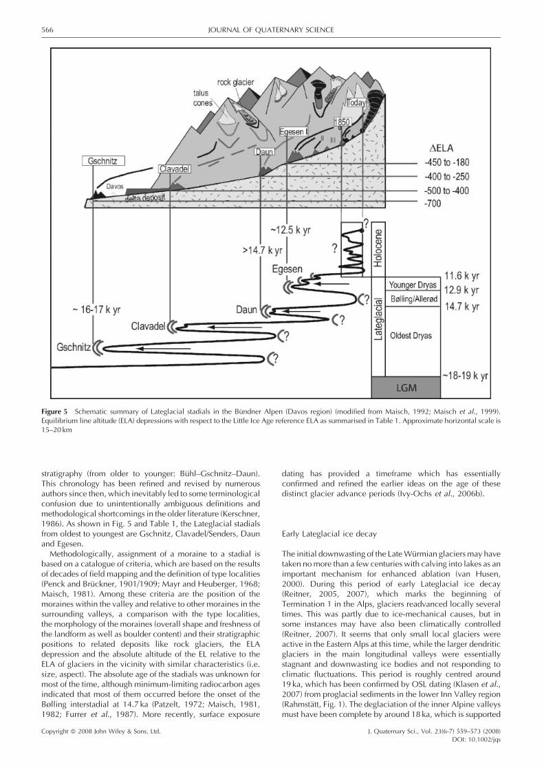
stratigraphy (from older to younger: Buhl–Gschnitz–Daun).This chronology has been refined and revised by numerousauthors since then, which inevitably led to some terminologicalconfusion due to unintentionally ambiguous definitions andmethodological shortcomings in the older literature (Kerschner,1986). As shown in Fig. 5 and Table 1, the Lateglacial stadialsfrom oldest to youngest are Gschnitz, Clavadel/Senders, Daunand Egesen.Methodologically, assignment of a moraine to a stadial is
based on a catalogue of criteria, which are based on the resultsof decades of field mapping and the definition of type localities(Penck and Bruckner, 1901/1909; Mayr and Heuberger, 1968;Maisch, 1981). Among these criteria are the position of themoraines within the valley and relative to other moraines in thesurrounding valleys, a comparison with the type localities,the morphology of the moraines (overall shape and freshness ofthe landform as well as boulder content) and their stratigraphicpositions to related deposits like rock glaciers, the ELAdepression and the absolute altitude of the EL relative to theELA of glaciers in the vicinity with similar characteristics (i.e.size, aspect). The absolute age of the stadials was unknown formost of the time, although minimum-limiting radiocarbon agesindicated that most of them occurred before the onset of theBølling interstadial at 14.7 ka (Patzelt, 1972; Maisch, 1981,1982; Furrer et al., 1987). More recently, surface exposure
dating has provided a timeframe which has essentiallyconfirmed and refined the earlier ideas on the age of thesedistinct glacier advance periods (Ivy-Ochs et al., 2006b).
Early Lateglacial ice decay
The initial downwasting of the LateWurmian glaciers may havetaken nomore than a few centuries with calving into lakes as animportant mechanism for enhanced ablation (van Husen,2000). During this period of early Lateglacial ice decay(Reitner, 2005, 2007), which marks the beginning ofTermination 1 in the Alps, glaciers readvanced locally severaltimes. This was partly due to ice-mechanical causes, but insome instances may have also been climatically controlled(Reitner, 2007). It seems that only small local glaciers wereactive in the Eastern Alps at this time, while the larger dendriticglaciers in the main longitudinal valleys were essentiallystagnant and downwasting ice bodies and not responding toclimatic fluctuations. This period is roughly centred around19 ka, which has been confirmed by OSL dating (Klasen et al.,2007) from proglacial sediments in the lower Inn Valley region(Rahmstatt, Fig. 1). The deglaciation of the inner Alpine valleysmust have been complete by around 18 ka, which is supported
Figure 5 Schematic summary of Lateglacial stadials in the Bundner Alpen (Davos region) (modified from Maisch, 1992; Maisch et al., 1999).Equilibrium line altitude (ELA) depressions with respect to the Little Ice Age reference ELA as summarised in Table 1. Approximate horizontal scale is15–20 km
Copyright � 2008 John Wiley & Sons, Ltd. J. Quaternary Sci., Vol. 23(6-7) 559–573 (2008)DOI: 10.1002/jqs
566 JOURNAL OF QUATERNARY SCIENCE

by a number of radiocarbon dates for the start of earlycolonisation by vegetation in an ice-free environment (Reitner,2007). This phase of the early Lateglacial comprises the stadialsof Buhl and Steinach of the traditional morphostratigraphy(Penck and Bruckner, 1901/1909; Senarclens-Grancy, 1958).The concept of stadials does not hold for these advances, as theactive parts of the glaciers were still in contact with stagnant icemasses farther downvalley.
Gschnitz stadial
The first clear post-Late Wurmian readvance of mountainglaciers, when glacier termini were already situated well insidethe mountains, is recorded by the Gschnitz stadial moraines.Morphological evidence shows that glaciers advanced overice-free terrain for considerable distances (Kerschner andBerktold, 1982; Kerschner et al., 2002), indicating a truereadvance and not a stillstand during ice recession. A roughestimate is that about 80–90% of the Late Wurmian ice volumewas already gone. Gschnitz stadial moraines are tens of metreshigh and morphologically prominent, incorporating largeamounts of sediment. The ELA lowering at the type locality(Trins), which is located in the central Alps of Tyrol, was 700m.In regions closer to the northern fringe of the Alps, it was slightlyhigher, of the order of 800m, but in the southern chains closerto the Adriatic Sea it was around 1000m (Kerschner et al.,1999; Kerschner and Ivy-Ochs, 2008).The basal age of the Rodschitz peat bog (Traun Valley,
Austria; van Husen, 2004) of 15 400� 470 14C a BP (Draxler,1977, 1987) (18 020–19 100 cal. a BP) can be seen as amaximum age for Gschnitz advances, while 10Be surfaceexposure ages from several boulders on the Gschnitztype locality moraine at Trins provide a minimum age formoraine stabilisation there. Themean 10Be age is 15.4� 1.4 ka;the oldest age is 16.1� 1.0 ka (Ivy-Ochs et al., 2006a). Thesituation of the individual boulders shows that post-deposi-tional exhumation, overturning of blocks and rock surfacespalling enhanced by tree roots cannot be excluded (Ivy-Ochset al., 2006a,b, 2007). Dead ice hollows in the left-hand part ofthe moraine show that wide areas of the moraine consisted ofice-cored rockslide debris. Therefore, it is rather safe toconclude that the moraine was deposited some hithertounknown time (maybe a few centuries) before its finalstabilisation. This estimate is supported by a number ofradiocarbon dates from peat bogs inside areas that wereformerly covered by Gschnitz stadial glaciers (summarised inIvy-Ochs et al., 2006a). Similarly, pollen data point to ice-freeconditions even in the higher valleys during the Oldest Dryas(Furrer, 1991; Ammann et al., 1994; Wohlfarth et al., 1994;Burga and Perret, 1998). A comparison with the developmentof vegetation in the Alps (e.g. compilation by Vescovi et al.,2007) suggests that the Gschnitz stadial occurred around 17–17.5 ka after a distinct warming phase.
Clavadel/Senders stadial and Daun stadial
After the Gschnitz stadial, glaciers readvanced again withglacier tongues at higher altitudes, leaving prominentmoraines.After a type locality near Davos (Maisch, 1981, 1987) andanother near Innsbruck (Kerschner and Berktold, 1982), thisadvance is called the Clavadel stadial or Senders stadial, whichare probably equivalent. The available ELA depressions are ofthe order of 400–500m, with lower values in the more
sheltered positions. There are no 10Be ages available yet, butminimum radiocarbon ages show that the stadial clearlyoccurred before the onset of the Bølling warm phase at 14.7 ka(Ivy-Ochs et al., 2006a). The basal age of a peat bog at MalojaPass (13 515� 95 14C a BP; Studer, 2005) gives a minimum ageof about 16 ka (15 650–16 530 cal. a BP) for ice recession afterthe Clavadel stadial (Upper Engadine: Cinuos-chel stadial) and,as a consequence, also for the preceding Gschnitz stadial.Upvalley from the Clavadel/Senders moraines, a series of
moraines can be observed. They are usually of a rather subduedmorphology with clear solifluction overprint. Such morainesare classified as Daun stadial in the sense of Heuberger (1966).Field relationships suggest that at some localities the moraineswere deposited in close connection with the Clavadel/Sendersstadial. In fact, the Daun stadial may be not muchmore than the‘appendix’ of the preceding Clavadel/Senders stadial. Pollenanalysis of sediment from the Crap Alv peat bog suggests a pre-Bølling age for the Daun stadial (Burga in Maisch, 1981). Asingle 10Be exposure date from an eroded Daun moraine (IlDschember site) east of Julier Pass yielded a pre-Egesenminimum age (Ivy-Ochs et al., 2006b). A preliminary 10Be datefrom a bedrock wall just outside the prominent Egesen morainecomplex of Morteratsch Glacier at Pontresina (Upper Engadin,eastern Swiss Alps) yielded an age in the region of 15.5 ka. Thisdate supports the assumed pre-Bølling age of the glaciallandscape right outside the ice margins of Younger Dryasmoraines (Maisch, unpublished data).The rapid warming at the onset of the Bølling interstadial at
14.7 ka put an end to the series of glacier advances. During theLateglacial interstadial (Bølling/Allerød), a number of climaticoscillations occurred, which likely led to glacier advancesbeyond the LIA extent, as can be inferred from sedimentolo-gical analysis of the Upper Engadine Lakes (Switzerland;Ohlendorf, 1998), but the moraines were overrun and wipedout during the successive period of glacier advances of theYounger Dryas.
Egesen stadial
The Younger Dryas cold phase is represented by the morainesof the Egesen stadial in the sense of Heuberger (1966). Outsideof the LIA moraines, the moraines that were constructed duringthe Egesen stadial are by far the most spectacular and are foundin numerous valleys throughout both the Eastern and WesternAlps (Kerschner et al., 2000, and references therein). During thepast few decades, Egesen moraines were mapped by a numberof authors (see bibliographies in Furrer et al., 1987, andKerschner et al., 2000). For field mapping, Egesen is defined asa series of morphologically fresh, steep-walled and often well-preserved moraines downvalley from the LIA moraines. Themaximum Egesen advance is characterised by a clearmorphological boundary; older moraines farther downvalleyshow much more subdued forms and clear signs of post-depositional solifluction overprint (Daun stadial). Egesenmoraines are sometimes prominent landmarks with localnames like the ‘Grand Toıt’ (‘Big Roof’) moraine in the Val deNendaz in south-west Switzerland (Muller et al., 1981). Twoand sometimes three distinct groups of moraines can bedistinguished. In many places, Egesen moraines are typicallyrich in large blocks and boulders, in particular those of thesecond phase (Bocktentalli phase). Along the central E–W axisof the Alps, ELA depressions associated with the Egesenmaximum moraines are of the order of 200m, but closer to thenorthern and western fringe they are clearly larger, with localextremes of up to 400m (Kerschner, 1978b; Maisch, 1981,
Copyright � 2008 John Wiley & Sons, Ltd. J. Quaternary Sci., Vol. 23(6-7) 559–573 (2008)DOI: 10.1002/jqs
CHRONOLOGY OF THE LAST GLACIAL CYCLE IN THE EUROPEAN ALPS 567

1987). South of the Alpine main divide, ELA depressions are ofthe order of 200m (Kerschner et al., 2000).Surface exposure dating of moraines of the Egesen maximum
at Julier Pass (Fig. 1) and Schonferwall (Ferwall in Fig. 1) givesaverage moraine stabilisation ages of 12.3� 1.5 ka (threeboulders) and 12.2� 1.0 ka (four boulders), respectively (Ivy-Ochs et al., 1996, 1999, 2006b). Slightly younger 10Be agesfrom four boulders (10.6 to 11.9 ka; recalculated from data inKelly et al., 2004b), with a mean age of 11.2� 1.1 ka, wereobtained for the Egesen maximum left lateral moraine of theGreat Aletsch Glacier (Fig. 1). At Julier Pass, exposure datesfrom the hummocky innermoraine (likely Bocktentalli Egesen IIphase) indicate final stabilisation around 11.3� 0.9 ka (threeboulders) (Ivy-Ochs et al., 1996, 1999, 2006b). Similarly, at ValViola (Fig. 1) the average of two 10Be boulder ages,11.2� 0.9 ka, provides a stabilisation age for the first innermoraine of the Alp Dosde Egesen moraine complex (Hormeset al., 2008).Rock glaciers developed in many places during the Egesen
stadial, sometimes advancing into areas which became ice freeright after the Egesen maximum advance. They indicate thepresence of permafrost at that time down to 2000–1900m a.s.l.(Kerschner, 1978a; Sailer and Kerschner, 1999; Frauenfelderet al., 2001). At Julier Pass, a rock glacier developed from melt-out till and slope debris in the region just inside the right lateralmoraine (Frauenfelder et al., 2001). The data show that rockglacier activity continued throughout the later part of theYounger Dryas and finally ended after the Preboreal oscillation(see also below). Glaciers in the Grimsel Pass region (Switzer-land) receded from their Younger Dryas extent between 11.7and 10.8 ka (Kelly et al., 2006; Ivy-Ochs et al., 2006b, 2007).Radiocarbon dates for the abandoned former glacier tongue
regions provideminimum-limiting dates for final decay of Egesenglaciers (sites shown in Fig. 1). Minimum radiocarbon ages forthe Egesen maximum of the Otztal Glacier are 10 235�80 14C a BP (12110–11760 cal. a BP) and 10 100� 115 14C a BP(12 100–11 400 cal. a BP). In both cases it can be shown thattrees already existed at an altitude of 1800m a.s.l., whichsurvived the YoungerDryas cold phase above the lateralmoraineof the Egesen glacier (Bortenschlager, 1984). An age of9950� 290 14C a BP (12150–11050 cal. a BP) was obtainedfor a site 15 km upvalley from the end moraines of the Egesenmaximum in Otztal. An age of 9630� 95 14C a BP (11250–10790 cal. a BP) at an altitude of 2155m a.s.l. is a minimum agefor the innermost moraine system (Kerschner, 1978b; Weirichand Bortenschlager, 1980) of a local glacier in the StubaiMountains near Innsbruck. Radiocarbon dates from sites furtherto the west give similar minimum ages for downwasting ofEgesen glaciers. A minimum age of 9635� 160 14C a BP(11190–10770 cal. a BP) was obtained by Beeler (1977) forinside the Egesen moraines of the Palu Glacier. Renner (1982)reports a minimum age of 9730� 120 14C a BP (11250–10800cal. a BP) from the Gotthard region. Further to the west, inSaastal, Bircher (1982) obtained a minimum age of9760� 175 14C a BP (11390–10780 cal. a BP) for the end ofthe Egesen stadial.
Kartell Stadial
In many valleys, in a variable but clear horizontal distanceoutside the LIA moraines (generally <1 km), prominentmoraines can be distinguished. In the Ferwall group (Fig. 1)they were named ‘Kartell Stadial’ (Fraedrich, 1979). The ELAdepression is 120m. At the Kartell site, three boulders gave10Be ages ranging between 10.4 and 11.2 ka with a mean of10.8� 1.0 ka (Ivy-Ochs et al., 2006b). Taken as minimum ages
being close to the time of deposition the Kartell moraines wereprobably deposited during the Preboreal oscillation. Similarly,small rock glaciers that had developed in the sediment-richnewly ice-free forefields of Egesen glaciers remained activewell into the Preboreal. This was determined at Julier Pass, forexample, where rock glacier activity in the Egesen complexdeposits persisted until 10.4� 0.4 ka (Ivy-Ochs et al., 2006b).
Discussion
One of the most important open questions with regard to theenvironmental history of the Alps is whether or not post-Eemianglaciers reached the lowlands prior to the well-documented lastglaciation (Late Wurmian), which occurred between about 30and 18 ka ago. In particular, important glaciations during MIS 4and, to some extent, during MIS 5d have been discussed. Asdiscussed above, the evidence for the presence and the extentof such glaciers decreases from the Western to Eastern Alps.While evidence for the existence of major glaciations in theWestern Alps during MIS 4 is convincing, no such evidence hasbeen found in the Eastern Alps. Indeed, in the French Alps itis even considered that the last maximum extent of glaciersoccurred during MIS 4 rather than MIS 2 (Guiter et al., 2005),but the dating evidence is equivocal (Preusser et al., 2006).Originally, the idea of Early Wurmian glaciations was raisedfrom the fact that three insolation minima occurred during thelast 100 ka (Koppen and Wegener, 1924). The theory of EarlyWurmian glaciations was later supported by palynologicalevidence. Welten (1981, 1982) pointed out that the environ-mental conditions during MIS 5d and MIS 4 were cool to coldbut temporarily also rather humid. Such conditions likelycaused glacial advances. The fact that more pronouncedadvances have been identified in the west may be explained bythree different scenarios (or a combination of all three). Firstly,it may be possible that the geological evidence is either notrecorded, it has since been eroded or that it has not yet beenidentified in the Eastern Alps. Secondly, it has to be kept inmindthat the Western Alps are on average about 1000m higher thanthe Eastern Alps and, accordingly, potential ice accumulationareas are larger. Additionally, in many cases the distance fromthe highest peaks to the foreland is shorter than farther to theeast. Thirdly, atmospheric circulation and hence sources ofmoisture were most likely different in the past from today. Forthe Late Wurmian this has been elucidated by Florineth andSchluchter (2000) (see below) but little is actually known aboutweather patterns prior to the LateWurmian. A possible scenariowould be that storm tracks had a more westerly direction thantoday and moisture was, as a consequence, mainly suppliedtowards the western part of the Alps (mainly French Alps)during the EarlyWurmian. This, in combination with the higherelevation of the Western Alps, may explain the apparentdiscrepancy in the geological record but needs to be confirmedby fieldwork and dating.
The last glaciation (Late Wurmian) of the lowlands occurredsometime after 30 ka ago. 10Be exposure ages from the RhoneGlacier Wangen site show that terminal moraines had alreadybegun to stabilise by 21.0 ka (Ivy-Ochs et al., 2004, 2006b). Thetwo oldest 10Be ages from the Isar–Loisach Late Wurmian endmoraines agree within the stated errors with the youngerboulder age from the Wangen site. In the latter case prolongedmoraine instability perhaps related to periglacial activity mayhave led to ‘too young’ exposure ages (Reuther et al., 2006;Reuther, 2007). Both datasets, in concert with OSL andradiocarbon data, support the hypothesis that Alpine piedmont
Copyright � 2008 John Wiley & Sons, Ltd. J. Quaternary Sci., Vol. 23(6-7) 559–573 (2008)DOI: 10.1002/jqs
568 JOURNAL OF QUATERNARY SCIENCE

glaciers reached their maximum extents during the Last GlacialMaximum (MIS 2) (cf. Schaefer et al., 2006). Based on theconfiguration of ice domes and main ice accumulation areas inthe Alps, notably the evidence of northward ice transfluencesover numerous passes (for example at Grimsel Pass; Florinethand Schluchter, 1998), Florineth and Schluchter (2000)proposed that during the Late Wurmian weather patterns weredominated by southerly airflow. The oceanic polar front, withassociated storm tracks, was displaced southwards to thelatitude of Spain and Italy. Consequently, the MediterraneanSea was the most important source of moisture for glaciersin the Alps during the Late Wurmian, whereas the partly frozenNorth Atlantic Ocean played only a minor role. An importantquestion therefore is the synchrony of deglaciation in bothspace and time across the Alps, not only with respect to west toeast but also north to south. Recently reported radiocarbondates from the Tagliamento morainic amphitheatre in NE Italyshow that glacier advances were synchronous with those on thenorthern forelands (Monegato et al., 2007). In the Tagliamentomorainic amphitheatre a two-phased glacial maximum ispresent. The older more extensive advance was between 26.5and 23 cal. ka, while the younger advance between 24 and21 cal. ka is contemporaneous with the maximum extent in thenorthern forelands. This agrees well with van Husen’s (2004)description of an early Maximalstand and subsequent Hoch-stand for the two main advances of the Late Wurmian TraunGlacier (Fig. 1) (cf. Monegato et al., 2007). 10Be data fromboulders on moraines in the Ivrea morainic amphitheatre inNW Italy (Gianotti et al., 2008) support the hypothesis that theonset of ice decay at 20.8� 1.5 ka in the southern rangesoccurred simultaneously with the northern regions.In the Eastern Alps, both radiocarbon and OSL data point to
ice-free longitudinal valleys already by 18–19 ka (van Husen,2000; Klasen et al., 2007). The oldest date yet obtained for anice-free Swiss foreland is 17–18 ka, but it is a minimum age.Pinning down the timing during this period remains difficult.Organic material for radiocarbon dating is rare and is oftenreworked. Exposure dating of early Lateglacial deposits isproblematic as this period is largely defined by ice-marginallandforms such as kame terraces (Reitner, 2005, 2007); largeboulders suitable for exposure dating are rare.Around 17 ka, after more than 80% of the Late Wurmian ice
volume had been lost, glaciers readvancedmarkedly during theGschnitz stadial. From a glacier flow model it can be inferredthat the glacier at the Gschnitz type locality was still of thesubarctic type with low basal shear stresses, low flow velocitiesand correspondingly flat ablation gradients (Kerschner et al.,1999; Ivy-Ochs et al., 2006a). Accumulation must have beenvery low, and summer temperatures must have been low aswell. According to the model, precipitation in the central Alpsof Tyrol reached only about 30% of its present-day values.Summer temperatures were about 9–118C lower than today(Kerschner et al., 1999; Ivy-Ochs et al., 2006a). Comparativelyhigh ELA depressions in the Southern Alps indicate thatprecipitation was less reduced there, whereas in the northernchains the situation resembled that in the well-shielded centralvalleys (Kerschner and Ivy-Ochs, 2008). This implies that a LateWurmian-type circulation pattern with moisture advectiondominantly from the south (Florineth and Schluchter, 2000)persisted well into the Gschnitz stadial.Moraines that likely formed during the Gschnitz stadial can
be found in many tributary valleys but appear to be missing inmost of the main valleys, where glaciers at that time were stilllarge (Ivy-Ochs et al., 2006a). For example, in the RhoneValley, the upper Aare Valley and its tributaries, or the Swiss/Tyrolean Inn Valley, Gschnitz moraines have not been founddespite almost a century of mapping. An important open
question is whether such moraines were not formed (manyglaciers were probably calving into lakes), whether they werenot preserved or whether they are simply buried. Because of thelikely association of Gschnitz advances with changes in NorthAtlantic Ocean circulation (Heinrich event 1), clear identifi-cation of glacier extents during this time period is crucial.Further identification of datable Gschnitz stadial moraines isneeded to map out patterns in space and time across the Alpsduring the early Lateglacial.Although based on the available evidence it is likely that the
Daun and Clavadel/Senders stadials took place before the onsetof the Bølling interstadial, direct dating of these moraines is stilllacking.The Younger Dryas was a relatively long (ca. 1300 a) and
climatically unstable period (Kerschner et al., 2000). Morainesdeposited during the Egesen stadial show marked regionalvariations. In some valleys several Egesen moraines are foundspread out over a few kilometres. In other cases moraines areclosely nested or even cross-cutting (Maisch, 1981). On thebasis of the ELA depressions of the Egesen maximum advance,early Younger Dryas precipitation patterns can be inferred withsimple glacier–climate models (Kerschner et al., 2000;Kerschner and Ivy-Ochs, 2008). In general, under theassumption of a summer temperature lowering of 3.58C ratherhumid conditions prevailed along the western and northernmargins of the Alps in western Austria and eastern Switzerland,whereas in the well-shielded valleys of the interior and alsoalong the southern margin climate was clearly drier than todaywith precipitation reduced by 20–30%. During the secondphase of the Younger Dryas, climate was much drierthroughout the study area. A reduction of annual precipitationby 50% in the central valleys seems to be realistic. The spatialpattern of precipitation change suggests an atmosphericcirculation pattern with predominantly westerly to north-westerly airflow.The age of the frequently found moraines that lie just beyond
the LIA moraines appears to be early Holocene but this is basedonly on data from the Kartell site (Ivy-Ochs et al., 2006b). Thistime period roughly corresponds to the ‘Palu’ cold event thatwas identified in the Central Alps based on pollen andlithological data in bog sediments (Zoller et al., 1998).Nevertheless, whether all the similar ‘intermediate moraines’found between the LIA and Egesen moraines were depositedduring the Preboreal oscillation remains an open question. Inany case the Kartell moraines show that the transition betweenYounger Dryas and Holocene climatic conditions wasinterrupted by marked periods of glacier-friendly climate.
Conclusions
Clarification of the timing for maximum ice extent across theAlps during the last glacial cycle is crucial. For the Swiss Alps,major glaciations duringMIS 5d and 4 have been inferred basedon interpretation of lithostratigraphy and luminescence dating,but no terminal landforms are preserved. They were obliteratedduring the subsequent more extensive Late Wurmian (MIS 2)advances. In stark contrast, no such evidence for significantEarly or Middle Wurmian glaciations has yet been found in theEastern Alps. Similarly, few good tie points are available for theLateglacial glacier readvances apart from the definitive linkingof the Egesen with the Younger Dryas. Indeed, there are still aconsiderable number of open questions regarding the corre-lation between the Lateglacial moraine sequences of the
Copyright � 2008 John Wiley & Sons, Ltd. J. Quaternary Sci., Vol. 23(6-7) 559–573 (2008)DOI: 10.1002/jqs
CHRONOLOGY OF THE LAST GLACIAL CYCLE IN THE EUROPEAN ALPS 569

Eastern and Western Alps. Additional detailed field investi-gations and dating are required to resolve some of thesedifferences and clarify regional variations.The location of the Alps downwind from the North Atlantic
Ocean and its radically changing circulation patterns (shifts ofthe oceanic polar front; changes in deep water formation) leadsto significant variations in moisture delivery through time. Thisfact is amplified by the sweeping length of the Alps and theirarching shape, which results in different weather patternsdominating across their length and width during given timeintervals. Key information about past changes can beelucidated through the study of the glacial record. Detailedlitho- and morphostratigraphic mapping provides relative ice-marginal positions in an age sequence but direct dating iscrucial. Looking at it from the other side, the detailed mappingover vast regions of the Alps affords a strong foundation againstwhich the results of the various dating methods can becompared and evaluated.
Acknowledgements We thank M. Fiebig and J. Ehlers for thoroughcritical reviews. This research was partially funded by ETH grant 0-20-624-92, Swiss Nationalfond grants 21-043469.95/1 and 21-063988.00/1 to C. Schluchter, by Austrian Science Foundation (FWF) grantP-15108-N06 to H. Kerschner, and German Science Foundation grantsDFG-Az: He 722/32-1/2 to K. Heine and RA 383/13-1 to F. Preusser andU. Radtke.We sincerely acknowledge the dedication of our acceleratorcrew. The Zurich AMS facility is jointly operated by the Swiss FederalInstitute of Technology, Zurich, and by the Paul Scherrer Institute,Villigen, Switzerland.
References
Agassiz L. 1840. Etudes sur les Glaciers. Jent & Gassman: Neuchatel,Switzerland.
Ammann B, Lotter AF, EicherU, GaillardM-J,Wohlfarth B, HaeberliW,Lister G, Maisch M, Niessen F, Schluchter C. 1994. The WurmianLate-glacial in lowland Switzerland. Journal of Quaternary Science 9:119–125.
Beeler FN. 1977. Geomorphologische Untersuchungen am Spat- undPostglazial im schweizerischen Nationalpark und im Bernina-paßgebiet (sudratische Alpen). Ergebnisse der wissenschaftlichenUntersuchungen im schweizerischen Nationalpark 15: 131–276.
Bircher W. 1982. Zur Gletscher- und Klimageschichte des Saastales:glazialmorphologische und dendroklimatologische Untersuchun-gen. Physische Geographie 9: 1–233.
Bortenschlager S. 1984. Beitrage zur Vegetationsgeschichte Tirols I.Inneres Otztal und unteres Inntal. Berichte des Naturwissenschaf-tlich-Medizinischen Vereins in Innsbruck 71: 19–56.
Bronk Ramsey C. 2001. Development of the radiocarbon calibrationprogram OxCal. Radiocarbon 43: 355–363.
Burga CA, Perret R. 1998. Vegetation und Klima der Schweiz seit demjungeren Eiszeitalter. Ott Verlag: Thun, Switzerland.
Chaline J, Jerz H. 1984. Arbeitsergebnisse der Subkomission fur Euro-paische Quartarstratigraphie: Stratotypen des Wurm-Glazials (Ber-icht SEQS 5). Eiszeitalter und Gegenwart 34: 185–206.
Cogley JG, Adams WP, Ecclestone MA, Jung-Rothenhausler F, Oman-ney CSL. 1996. Mass balance of White Glacier, Axel Heiberg Island,NWT, Canada, 1960–91. Journal of Glaciology 42: 548–563.
Coope GR. 2007. Coleoptera from the 2003 excavations of the mam-moth skeleton at Niederweningen, Switzerland. Quaternary Inter-national 164/165: 130–138.
de Beaulieu J-L, Reille M. 1992. The last climatic cycle at La Grand Pile(Vosges, France): a new pollen profile. Quaternary Science Reviews11: 431–438.
de Charpentier J. 1841. Essai sur les glaciers et sur le terrain erratique duBassin du Rhone. Ducloux: Lausanne, Switzerland.
Draxler I. 1977. Pollenanalytische Untersuchungen von Moorenzur Spat- und postglazialen Vegetationsgeschichte im Einzugsgebietder Traun. Jahrbuch der Geologischen Bundesanstalt 120: 131–163.
Draxler I. 1987. Zur Vegetationsgeschichte und Stratigraphie desWurmspatglazials des Traungletschergebietes. In: Das Gebiet desTraungletschers, Oberosterreich: Eine Typregion desWurm-Glazials,van Husen D (ed.). Mitteilungen der Kommission fur Quartar-forschung der Osterreichischen Akademie der Wissenschaften 7:19–35.
Drescher-Schneider R. 2000. Die Vegetations- und Klimaentwicklungim Riss/Wurm-Interglazial und im Fruh- und Mittelwurm in derUmgebung von Mondsee. Ergebnisse der pollenanalytischen Unter-suchungen. Mitteilungen der Kommision fur Quartarforschung derOsterreichischen Akademie der Wissenschaften 12: 39–92.
Drescher-Schneider R, Jacquat C, Schoch W. 2007. Palaeobotanicalinvestigations at the mammoth site of Niederweningen (KantonZurich), Switzerland. Quaternary International 164/165: 113–129.
Ehlers J, Gibbard PL (eds). 2004. Quaternary Glaciations: Extent andChronology Part I: Europe. Elsevier: London.
Feldmann L. 1992. Ehemalige Ammerseestande im Hoch und Spatgla-zial des Wurms. Eiszeitalter und Gegenwart 42: 52–61.
Fiebig M, Preusser F. 2003. Das Alter fluvialer Ablagerungen aus derRegion Ingolstadt (Bayern) und ihre Bedeutung fur die Eiszeitenchro-nologie des Alpenvorlandes. Zeitschrift fur Geomorphologie – NeueFolge 47: 449–467.
Fiebig M, Buiter SJH, Ellwanger D. 2004. Pleistocene glaciations ofSouth Germany. In Quaternary Glaciations: Extent and ChronologyPart I: Europe. Elsevier: London; 147–154.
Fliri F. 1973. Beitrage zur Geschichte der alpinen Wurmvereisung:Forschungen am Banderton von Baumkirchen (Inntal, Nordtirol).Zeitschrift fur Geomorphologie NF Supplementband 16: 1–14.
Fliri F. 1974. Niederschlag und Lufttemperatur im Alpenraum, Wis-senschaftliche Alpenvereinshefte 24. Wagner: Innsbruck.
Fliri F, Bortenschlager S, Felber H, Heissel W, Hilscher H, Resch W.1970. Der Banderton von Baumkirchen (Tirol). Zeitschrift furGletscherkunde und Glazialgeologie 6: 5–35.
Florineth D. 1998. Surface geometry of the Last Glacial Maximum(LGM) in the southeastern Swiss Alps (Graubunden) and its paleo-climatological significance. Eiszeitalter und Gegenwart 48: 23–37.
Florineth D, Schluchter C. 1998. Reconstructing the Last GlacialMaximum (LGM) ice surface geometry and flowlines in the CentralSwiss Alps. Eclogae geologicae Helvetiae 91: 391–407.
Florineth D, Schluchter C. 2000. Alpine evidence for atmosphericcirculation patterns in Europe during the Last Glacial Maximum.Quaternary Research 54: 295–308.
Fraedrich R. 1979. Spat-und postglaziale Gletscherschwankungen inder Ferwallgruppe (Tirol/Vorarlberg). Dusseldorfer GeographischeSchriften 12: 1–161.
Frauenfelder R, Haeberli W, Hoelzle M, Maisch M. 2001. Using relictrockglaciers in GIS-based modelling to reconstruct Younger Dryaspermafrost distribution patterns in the Err-Julier area, Swiss Alps.Norsk Geografisk Tidsskrift/Norwegian Journal of Geography 55:195–202.
Frei C, Schar C. 1998. A precipitation climatology of the Alps from high-resolution rain-gauge observations. International Journal of Clima-tology 18: 873–900.
Frenzel B. 1991. Uber einen fruhen letzteiszeitlichen Vorstoß desRheingletschers in das deutsche Alpenvorland. In Klimageschich-tliche Probleme der letzten 130000 Jahre, Frenzel B (ed.). G. FischerVerlag: Stuttgart/New York; 377–400.
Furrer G. 1991. 25,000 Jahre Gletschergeschichte. Veroffentlichungender Naturforschenden Gesellschaft in Zurich, Neujahrsblatt auf dasJahr 1991; 52 pp.
Furrer G, Burga C, Gamper M, Holzhauser H, Maisch M. 1987. ZurGletscher-, Vegetations- und Klimageschichte der Schweiz seit derSpateiszeit. Geographica Helvetica 42: 61–91.
Geyh MA, Hennig G, Oetzen D. 1997. U/Th-Datierung interglazialerund interstadialer Niedermoortorfe und Lignite: Stand und Zukunft.Schriftenreihe der Deutschen Geologischen Gesellschaft 4: 187–199.
Gianotti F, FornoMG, Ivy-Ochs S, Kubik PW. 2008.New chronologicaland stratigraphical data on the Morainic Amphiteatre of Ivrea (Pied-mont, NW Italy). Quaternary International (in press).
Copyright � 2008 John Wiley & Sons, Ltd. J. Quaternary Sci., Vol. 23(6-7) 559–573 (2008)DOI: 10.1002/jqs
570 JOURNAL OF QUATERNARY SCIENCE

Gosse JC, Phillips FM. 2001. Terrestrial in situ cosmogenic nuclides:theory and application. Quaternary Science Reviews 20: 1475–1560.
Gross G, Kerschner H, Patzelt G. 1977. Methodische Untersuchungenuber die Schneegrenze in alpinen Gletschergebieten. Zeitschrift furGletscherkunde und Glazialgeologie 12: 223–251.
Gruger E. 1979. Spatriss, Riss/Wurm und Fruhwurm am Samerberg inOberbayern: ein vegetationsgeschichtlicher Beitrag zur Gliederungdes Jungpleistozans. Geologica Bavarica 80: 5–64.
Gruger E, Schreiner A. 1993. Riss/Wurm- und wurmzeitliche Ablager-ungen im Wurzacher Becken (Rheingletschergebiet). Neues Jahr-buch fur Geologie und Palaontologie Abhandlungen 189: 81–117.
Guiter F, TriganonA, Andrieu-Ponel V, Ponel P, Hebrard J-P, NicoudG,Beaulieu J-L de, Brewer S, Guibal F. 2005. First evidence of ‘in-situ’Eemian sediments on the high plateau of Evian (Northern Alps,France): implications for the chronology of the Last Glaciation.Quaternary Science Reviews 24: 35–47.
Habbe KA, Jerz H, Doppler G. 1996. Schieferkohlen bei Wasserburgam Inn. Field Trip Guide, DEUQUA 15-16.09.1996. Gmunden,Austria. Vierteljahresschrift der Naturforschenden Gesellschaft inZurich.
Hadorn P, Thew N, Coope GR, Lemdahl G, Hajdas I, Bonani G. 2002.A Late-Glacial and early Holocene environment and climate historyfor the Neuchatel region (CH). In Equilibres et ruptures dans lesecosystemes depuis 20 000 ans en Europe de l’Ouest, Richard H,Vignot A (eds). Collection Annales Litteraires, Serie Environment,Societes et Archeologie 3: 75–90.
Haeberli W. 1991. Zur Glaziologie der letzteiszeitlichen Alpenvergle-tscherung. In Klimageschichtliche Probleme der letzten 130000Jahre, Frenzel B (ed.). G. Fischer Verlag: Stuttgart/New York;409–419.
Hajdas I, Bonani G, Furrer H, Mader A, Schoch W. 2007. Radiocarbonchronology of the mammoth site at Niederweningen, Switzerland:results from dating bones, teeth, wood, and peat. Quaternary Inter-national 164/165: 98–105.
Heuberger H. 1966. Gletschergeschichtliche Untersuchungen in denZentralalpen zwischen Sellrain und Otztal.Wissenschaftliche Alpen-vereinshefte 20. Universitatsverlag Wagner: Innsbruck.
Hormes A, Ivy-Och S, Kubik PW, Ferreli L, Michetti AM. 2008.10Be exposure ages of a rock avalanche and a late glacial morainein Alta Valtellina, Italian Alps. Quaternary International (in press).
Hughen K, Southon J, Lehman S, Bertrand C, Turnbull J. 2006. Marine-derived 14C calibration and activity record for the past 50,000 yearsupdated from the Cariaco Basin. Quaternary Science Reviews 25:3216–3227.
Ivy-Ochs S. 1996. The dating of rock surfaces using in situ produced10Be, 26Al and 36Cl, with examples from Antarctica and the SwissAlps. PhD dissertation No. 11763, ETH Zurich.
Ivy-Ochs S, Schluchter C, Kubik PW, Synal H-A, Beer J, Kerschner H.1996. The exposure age of an Egesen moraine at Julier Pass, Switzer-land, measured with the cosmogenic radionuclides 10Be, 26Al and36Cl. Eclogae geologicae Helvetiae 89: 1049–1063.
Ivy-Ochs S, Schluchter C, Kubik PW, Denton G. 1999. Moraineexposure dates imply synchronous Younger Dryas glacier advancesin the European Alps and in the Southern Alps of New Zealand.Geografiska Annaler 81A: 313–323.
Ivy-Ochs S, Schafer J, Kubik PW, Synal H-A, Schluchter C. 2004. Thetiming of deglaciation on the northern Alpine foreland (Switzerland).Eclogae geologicae Helvetiae 97: 47–55.
Ivy-Ochs S, Kerschner H, Kubik PW, Schluchter C. 2006a. Glacierresponse in the European Alps to Heinrich event 1 cooling:the Gschnitz stadial. Journal of Quaternary Science 21: 115–130.
Ivy-Ochs S, Kerschner H, Reuther A, Maisch M, Sailer R, Schaefer J,Kubik PW, Synal HA, Schluchter C. 2006b. The timing of glacieradvances in the northern European Alps based on surface exposuredating with cosmogenic 10Be, 26Al, 36Cl, and 21Ne. In In Situ-Pro-duced Cosmogenic Nuclides and Quantification of Geological Pro-cesses, Siame LL, Bourles DL, Brown ET (eds). Special Paper 415.Geological Society of America: Boulder, CO; 43–60.
Ivy-Ochs S, Kerschner H, Schluchter C. 2007. Cosmogenic nuclidesand the dating of glacier variations: the Alpine perspective. Qua-ternary International 164/165: 53–63.
Jerz H. 1987a. Erlauterungen zur Geologischen Karte von Bayern1:25,000 zum Blatt Nr. 8034 Starnberg Sud. Bayerisches Geolo-gisches Landesamt: Munchen.
Jerz H. 1987b. Erlauterungen zur Geologischen Karte von Bayern1:25,000 zum Blatt Nr. 7934 Starnberg Nord. Bayerisches Geolo-gisches Landesamt: Munchen.
Jerz H. 1993. Das Eiszeitalter in Bayern: Erdgeschichte, Gesteine,Wasser, Boden. Geologie von Bayern. Band 2. Schweizerbart: Stutt-gart.
Jost-Stauffer MA, Coope GR, Schluchter C. 2001. A coleopteran faunafrom the middle Wurm (Weichselian) of Switzerland and its bearingon palaeogeography, palaeoclimate and palaeoecology. Journal ofQuaternary Science 16: 257–268.
Jost-Stauffer MA, Coope GR, Schluchter C. 2005. Environmental andclimatic reconstructions during Marine Oxygen Isotope Stage 3 fromGossau, Swiss Midlands, based on coleopteran assemblages. Boreas34: 53–60.
Keller O, Krayss E. 1998. Datenlage und Modell einer Rhein-Linth-Vorlandvergletscherung zwischen Eem-Interglazial und Hochwurm.GeoArchaeoRhein 2: 121–138.
Keller O, Krayss E. 2005a. Der Rhein-Linth Gletscher im letztenHochglazial. 1. Teil: Einleitung: Aufbau und Abschmelzen desRhein-Linth-Gletschers im Oberen Wurm. Vierteljahresschrift derNaturforschenden Gesellschaft in Zurich 150: 19–32.
Keller O, Krayss E. 2005b. Der Rhein-Linth Gletscher im letztenHochglazial. 2. Teil: Datierung und Modelle der Rhein-Linth-Ver-gletscherung, Klimarekonstruktionen. Vierteljahresschrift der Natur-forschenden Gesellschaft in Zurich 150: 69–85.
Kelly MA, Buoncristiani J-F, Schluchter C. 2004a. A reconstruction ofthe last glacial maximum (LGM) ice-surface geometry in the westernSwiss Alps and contiguous Alpine regions in Italy and France.Eclogae geologicae Helvetiae 97: 57–75.
Kelly MA, Kubik PW, von Blanckenburg F, Schluchter C. 2004b.Surface exposure dating of the Great Aletsch Glacier Egesen morainesystem, western Swiss Alps, using the cosmogenic nuclide 10Be.Journal of Quaternary Science 19: 431–441.
Kelly MA, Ivy-Ochs S, Kubik PW, von Blanckenburg F, Schluchter C.2006. Exposure ages of glacial erosional features in the Grimsel Passregion, central Swiss Alps. Boreas 35: 634–643.
Kerschner H. 1978a. Paleoclimatic inferences from Late Wurm rockglaciers, eastern central Alps, western Tyrol, Austria. Arctic andAlpine Research 10: 635–644.
Kerschner H. 1978b. Untersuchungen zum Daun- und Egesenstadiumin Nordtirol und Graubunden (methodische Uberlegungen). Geo-graphischer Jahresbericht aus Osterreich 36: 26–49.
Kerschner H. 1986. Zum Sendersstadium im Spatglazial der nordlichenStubaier Alpen, Tirol. Zeitschrift fur Geomorphologie Supplement61: 65–76.
Kerschner H, Berktold E. 1982. Spatglaziale Gletscherstande undSchuttformen im Senderstal, nordliche Stubaier Alpen, Tirol.Zeitschrift fur Gletscherkunde und Glazialgeologie 17: 125–134.
Kerschner H, Ivy-Ochs S. 2008. Palaeoclimate from glaciers: examplesfrom the Eastern Alps during the Alpine Lateglacial and early Holo-cene. Global and Planetary Change 60: 58–71.
Kerschner H, Ivy-Ochs S, Schluchter C. 1999. Paleoclimatic interpret-ation of the early late-glacial glacier in the Gschnitz valley, CentralAlps, Austria. Annals of Glaciology 28: 135–140.
Kerschner H, Kaser G, Sailer R. 2000. Alpine Younger Dryas glaciers aspaleo-precipitation gauges. Annals of Glaciology 31: 80–84.
Kerschner H, Ivy-Ochs S, Schluchter C. 2002. Die Morane von Trinsim Gschnitztal. Innsbrucker Geographische Studien 33: 185–194.
Klasen N. 2007. Luminszenzdatierung glazifluvialer Sedimente imnordlichen Alpenvorland. PhD dissertation, Universitat zu Koln.
Klasen N, Fiebig M, Preusser F, Reitner JM, Radtke U. 2007. Lumines-cence dating of proglacial sediments from the Eastern Alps. Qua-ternary International 164/165: 21–32.
Koppen W, Wegener A. 1924. Die Klimate der geologischen Vorzeit.Borntraeger: Berlin.
Link A, Preusser F. 2006. Hinweise auf eine Vergletscherung desKemptener Beckens wahrend des Mittelwurms. Eiszeitalter undGegenwart 55: 65–88.
Copyright � 2008 John Wiley & Sons, Ltd. J. Quaternary Sci., Vol. 23(6-7) 559–573 (2008)DOI: 10.1002/jqs
CHRONOLOGY OF THE LAST GLACIAL CYCLE IN THE EUROPEAN ALPS 571

Lister GS. 1988. A 15,000-year isotopic record from Lake Zurich ofdeglaciation and climatic change in Switzerland. QuaternaryResearch 29: 129–141.
Magny M, Thew N, Hadorn P. 2003. Late-glacial and early Holocenechanges in vegetation and lake-level at Hauterive/Rouges-Terres, LakeNeuchatel (Switzerland). Journal of Quaternary Science 18: 31–40.
Maisch M. 1981. Glazialmorphologische und gletschergeschichtlicheUntersuchungen im Gebiet zwischen Landwasser-und Albulatal. (Kt.Graubunden, Schweiz.). Physische Geographie 3: 1–215.
Maisch M. 1982. Zur Gletscher- und Klimageschichte des alpinenSpatglazials. Geographica Helvetica 37: 93–104.
Maisch M. 1987. Zur Gletschergeschichte des alpinen Spatglazials:Analyse und Interpretation von Schneegrenzdaten. GeographicaHelvetica 42: 63–71.
Maisch M. 1992. Die Gletscher Graubundens. Rekonstruktion undAuswertung der Gletscher und deren Veranderungen seit demHoch-stand von 1850 im Gebiet der ostlichen Schweizer Alpen (Bundner-land und angrenzende Regionen). Physische Geographie 33A/33B.
Maisch M, Haeberli W. 1982. Interpretation geometrischer Parametervon Spatglazialgletschern im Gebiet Mittelbunden, SchweizerAlpen. In Beitrage zur Quartarforschung in der Schweiz, GamperM (ed.). Physische Geographie 1: 111–126.
MaischM,Wipf A, Denneler B, Battaglia J, Benz C. 1999.DieGletscherder Schweizer Alpen. Gletscherhochstand 1850, Aktuelle Vergle-tscherung, Gletscherschwund-Szenarien, Schlussbericht NFP 31,vdf-Verlag ETH: Zurich.
Martinson DG, Pisias NG, Hays JD, Imbrie J, Moore TC, Shackleton NJ.1987. Age dating and the orbital theory of the ice ages: developmentof a high resolution 0 to 300,000-year chronostratigraphy. Quatern-ary Research 27: 1–29.
Masarik J, Frank M, Schafer JM, Wieler R. 2001. Correction of in situcosmogenic nuclide production rates for geomagnetic field intensityvariations during the past 800,000 years. Geochimica et Cosmochi-mica Acta 65: 2995–3003.
Mayr F, Heuberger H. 1968. Type areas of Lateglacial and Postglacialdeposits in Tyrol, Eastern Alps. In Glaciations of the Alps, RichmondGM (ed.). Series in Earth Sciences no. 7. University of Colorado:Boulder, CO; 143–165.
Monegato G, Ravazzi C, Donegana M, Pini R, Calderoni G, Wick L.2007. Evidence of a two-fold glacial advance during the last glacialmaximum in the Tagliamento end moraine system (eastern Alps).Quaternary Research 68: 284–302.
Muller HN, Kerschner H, Kuttel M. 1981. Gletscher- und vegetations-geschichtliche Untersuchungen im Val de Nendaz (Wallis): einBeitrag zur alpinen Spatglazialchronologie. Zeitschrift fur Gletscher-kunde und Glazialgeologie 16: 61–84.
Muller UC, Pross J, Bibus E. 2003. Vegetation response to rapid climatechange in Central Europe during the past 140,000 yr based onevidence from the Furamoos pollen record. Quaternary Research59: 235–245.
Ohlendorf C. 1998. High Alpine lake sediments as chronicles forregional glacier and climate history in the Upper Engadine, south-eastern Switzerland. Dissertation ETH No. 12705, Shaker Verlag,Aachen.
Patzelt G. 1972. Die spatglazialen Stadien und postglazialen Schwan-kungen von Ostalpengletschern. Berichte der Deutschen Bota-nischen Gesellschaft 85: 47–57.
Penck A, Bruckner E. 1901/1909. Die Alpen im Eiszeitalter. Tauchnitz:Leipzig.
Preusser F. 1999a. Lumineszenzdatierung fluviatiler Sedimente: Fall-beispiele aus der Schweiz und Norddeutschland. Kolner Forum furGeologie und Palaontologie 3: 1–63.
Preusser F. 1999b. Luminescence dating of fluvial sediments andoverbank deposits from Gossau, Switzerland: fine grain dating.Quaternary Science Reviews 18: 217–222.
Preusser F. 2003. IRSL dating of K-rich feldspars using the SARprotocol: comparison with independent age control. Ancient TL21: 17–23.
Preusser F. 2004. Towards a chronology of the Late Pleistocene in thenorthern Alpine Foreland. Boreas 33: 195–210.
Preusser F, Degering D. 2007. Luminescence dating of the Niederwe-ningen mammoth site, Switzerland. Quaternary International 164/165: 106–112.
Preusser F, Graf HR. 2002. Erste Ergebnisse von Lumineszenzdatierun-gen eiszeitlicher Ablagerungen der Nordschweiz. Jahrbuch undMitteilungen des Oberrheinischen Geologischen Vereins 107:419–438.
Preusser F, Schluchter C. 2004. Dates from an important early LatePleistocene ice advance in the Aare Valley, Switzerland. Eclogaegeologicae Helvetiae 97: 245–253.
Preusser F, Geyh MA, Schluchter C. 2003. Timing of Late Pleistoceneclimate change in lowland Switzerland.Quaternary Science Reviews22: 1435–1445.
Preusser F, Schluchter C, Drescher-Schneider R, Ivy-Ochs S, Kelly M.2006. Comment on ’First evidence of ‘‘in-situ’’ Eemian sediments onthe high plateau of Evian (Northern Alps, France): implications for thechronology of the Last Glaciation’ by F Guiter, A. Triganon, V.Andrieu-Ponel, P. Ponel, J-P Hebrard, G. Nicoud, J-L de Beaulieu,S. Brewer, F. Guibal. Quaternary Science Reviews 25: 645–647.
Preusser F, Blei A, Graf HR, Schluchter C. 2007. Luminescence datingof Wurmian (Weichselian) proglacial sediments from Switzerland:methodological aspects and stratigraphical conclusions. Boreas 36:130–142.
Reimer PJ, Baillie MGL, Bard E, Bayliss A, Beck JW, Bertrand CJH,Blackwell PG, Buck CE, Burr GS, Cutler KB, Damon PE, Edwards RL,Fairbanks RG, Friedrich M, Guilderson TP, Hogg AG, Hughen KA,Kromer B, McCormac G, Manning S, Bronk Ramsey C, Reimer RW,Remmele S, Southon JR, Stuiver M, Talamo S, Taylor FW, vander Plicht J, Weyhenmeyer CE. 2004. IntCal04 atmospheric radio-carbon age calibration, 26-0cal kyr BP. Radiocarbon 46: 1029–1058.
Reitner J. 2005.Quartargeologie und Landschaftsentwicklung im RaumKitzbuhel-St. Johann i.T.-Hopfgarten (Nordtirol) vom Riss bis in dasWurm-Spatglazial (MIS 6-2). PhD dissertation, Universitat Wien.
Reitner J. 2007. Glacial dynamics at the beginning of Termination 1 inthe Eastern Alps and their stratigraphic implications. QuaternaryInternational 164/165: 64–84.
Renner F. 1982. Beitrage zur Gletschergeschichte des Gotthardgebietesund dendroklimatologische Analysen an fossilen Holzern. PhysischeGeographie 8: 1–180.
Reuther A. 2007. Surface exposure dating of glacial deposits from thelast glacial cycle: evidence from the Eastern Alps, the Bavarian Forest,the Southern Carpathians and the Altai Mountains. Relief–Boden–Palaoklima, 21. Schweizerbart: Stuttgart.
Reuther AU, Ivy-Ochs S, Heine K. 2006. Application of surfaceexposure dating in glacial geomorphology and the interpretationof moraine ages. Zeitschrift fur Geomorphologie Suppl 142: 335–359.
Sailer R, Kerschner H. 1999. Equilibrium line altitudes and rock glaciersin the Ferwall Group (Western Tyrol, Austria) during theYounger Dryas cooling event. Annals of Glaciology 28: 135–140.
Schaefer JM, DentonGH, Barrell DJA, Ivy-Ochs S, Kubik PW, AndersenBG, Phillips FM, Lowell TV, Schluchter C. 2006. Near-synchronousinterhemispheric termination of the last glacial maximum in mid-latitudes. Science 312: 1510–1513.
Schindler C. 2004. Zum Quartar des Linthgebiets zwischen Luchsin-gen, dem Walensee und dem Zurcher Obersee. In Beitrage zurGeologischen Karte der Schweiz, Landesgeologie BWG (ed.). Land-esgeologie: Bern; 1–324.
Schluchter C. 1991. Fazies und Chronologie des letzteiszeitlichenEisaufbaues im Alpenvorland der Schweiz. In KlimageschichtlicheProbleme der letzten 130000 Jahre, Frenzel B (ed.). G. Fischer:Stuttgart/New York; 401–407.
Schluchter C. 2004. The Swiss glacial record: a schematic summary. InQuaternary Glaciations: Extent and Chronology Part I: Europe. Else-vier: London; 413–418.
Schluchter C, Rothlisberger C. 1995. 100,000 Jahre Gletscher-geschichte. In Gletscher im standigen Wandel. vdf-Verlag ETH:Zurich; 47–63.
Schluchter C, Maisch M, Suter J, Fitze P, Keller WA, Burga CA,Wynistorf E. 1987. Das Schieferkohlen-Profil von Gossau (KantonZurich) und seine stratigraphische Stellung innerhalb der letztenEiszeit. Vierteljahrsschrift der Naturforschenden Gesellschaft in Zur-ich 132: 135–174.
Schoeneich P. 1998. Correlation du dernier maximum glaciaire et de ladeglaciation alpine avec l’enregistrement isotopique du Groenland.Quaternaire 9: 203–215.
Copyright � 2008 John Wiley & Sons, Ltd. J. Quaternary Sci., Vol. 23(6-7) 559–573 (2008)DOI: 10.1002/jqs
572 JOURNAL OF QUATERNARY SCIENCE

Schreiner A. 1992. Einfuhrung in die Quartargeologie. Schweizerbart:Stuttgart.
Senarclens-Grancy Wvon. 1958. Zur Glazialgeologie des Otztales undseiner Umgebung.Mitteilungen der GeologischenGesellschaftWien49: 257–313.
Shackleton NJ, Chapman M, Sanchez-Goni MF, Pailler D, Lancelot Y.2002. The classical marine isotope substage 5e.Quaternary Research58: 14–16.
Spotl C, Mangini A. 2002. Stalagmite from the Austrian Alps revealsDansgaard-Oeschger events during isotope stage 3: implications forthe absolute chronology of Greenland ice cores. Earth and PlanetaryScience Letters 203: 507–518.
Spotl C, Mangini A. 2006. U/Th age constraints on the absence of ice inthe central Inn Valley (eastern Alps, Austria) during Marine IsotopeStages 5c to5a. Quaternary Research 66: 167–175.
Stone JO. 2000. Air pressure and cosmogenic isotope production.Journal of Geophysical Research 105: 23753–23760.
Studer M. 2005. Gletschergeschichtliche Untersuchungen und geo-morphologische Kartierung im Raum Maloja-Val Forno. Ein Beitragzur regionalen Landschaftsgeschichte. Diplomarbeit Geogra-phisches Institut der Universitat Zurich.
Troll C. 1924. Der dilluviale Inn-Chiemseegletscher: Das geogra-phische Bild eines typischen Alpenvorlandgletschers. Forschungenzur deutschen Landes- und Volkskunde 23: 1–121.
van Husen D. 1977. Zur Fazies und Stratigraphie der jungpleistozanenAblagerungen im Trauntal (mit quartargeologischer Karte). Jahrbuchder Geologischen Bundesanstalt 120: 1–130.
van Husen D. 1997. LGM and Late-glacial fluctuations in the EasternAlps. Quaternary International 38/39: 109–118.
van Husen D. 2000. Geological processes during the Quaternary.Mitteilungen der Osterreichischen Geologischen Gesellschaft 92:135–156.
van Husen D. 2004. Quaternary glaciations in Austria. In QuaternaryGlaciations: Extent and Chronology Part I: Europe, Ehlers J, GibbardPL (eds). Elsevier: London; 1–13.
Venetz I. 1833. Memoire sur les variations de la temperature dans lesAlps de la Suisse. Denkschriften der Allgemeinen SchweizerischenGesellschaft fur die Gesamte Natur 1: 1–158.
Vescovi E, Ravazzi C, Arpenti E, FinsingerW, Pini R, Valsecchi V,WickL, Ammann B, Tinner W. 2007. Interactions between climate andvegetation during the Lateglacial period as recorded by lake andmiresediment archives in Northern Italy and Southern Switzerland. Qua-ternary Science Reviews 26: 1650–1669.
Visocekas R, Guerin G. 2006. TL dating of feldspars using their far-redemission to deal with anomalous fading. Radiation Measurements41: 942–947.
Wegmuller S. 1992. Vegetationsgeschichtliche und stratigraphischeUntersuchungen an Schieferkohlen des nordlichen Alpenvorlandes.Denkschriften der Schweizer Akademie fur Naturwissenschaften,102. Birkhauser: Basel.
Wegmuller S, Preusser F, Muller BU, Schluchter C. 2002. Palynostrati-graphische Untersuchung und Lumineszenzdatierung des ProfilsGalgenmoos und Implikationen fur die Chronologie des letztenGlazialzyklus im nordlichen Alpenvorland der Schweiz. Eclogaegeologicae Helvetiae 95: 115–126.
Weirich J, Bortenschlager S. 1980. Beitrage zur VegetationsgeschichteTirols III: Stubaier Alpen – Zillertaler Alpen. Berichte des naturwis-senschaftlich-medizinischen Vereins in Innsbruck 67: 7–30.
Welten M. 1981. Verdrangung und Vernichtung der anspruchsvollenGeholze am Beginn der letzten Eiszeit und die Korrelation derFruhwurm-Interstadiale in Mittel- und Nordeuropa. Eiszeitalterund Gegenwart 31: 187–202.
Welten M. 1982. Pollenanalystische Untersuchungen im JungerenQuartar des nordlichen Alpenvorlandes der Schweiz. Beitrage zurGeologischen Karte der Schweiz – Neue Folge 156: 1–174.
Wessels M. 1998. Natural environmental changes indicated by LateGlacial and Holocene sediments from Lake Constance, Germany.Palaeogeography, Palaeoclimatography, Palaeoecology 140: 421–432.
Wohlfarth B, Gaillard M-J, Haeberli W, Kelts K. 1994. Environmentsand climate in southwestern Switzerland during the lasttermination 15–10 ka BP.Quaternary Science Reviews 13: 361–394.
Zoller H, Athanasiadis N, Heitz-Weniger A. 1998. Late-glacial andHolocene vegetation and climate change at the Palu glacier, BerninaPass, Grisons Canton, Switzerland. Vegetation History and Archae-botany 7: 241–249.
Copyright � 2008 John Wiley & Sons, Ltd. J. Quaternary Sci., Vol. 23(6-7) 559–573 (2008)DOI: 10.1002/jqs
CHRONOLOGY OF THE LAST GLACIAL CYCLE IN THE EUROPEAN ALPS 573