CHRISTCHURCH SOUTHERN MOTORWAY STAGE 2 … · CHRISTCHURCH SOUTHERN MOTORWAY STAGE 2 & MAIN SOUTH...
21
CHRISTCHURCH SOUTHERN MOTORWAY STAGE 2 & MAIN SOUTH ROAD FOUR LANING: AN ARCHAEOLOGICAL ASSESSMENT KATHARINE WATSON NOVEMBER 2012 REPORT FOR THE NEW ZEALAND TRANSPORT AGENCY (NZTA) This Technical Report has been produced in support of the Assessment of Environmental Effects (AEE) for the Main South Road Four Laning and Christchurch Southern Motorway Stage 2 Project. It is one of 20 Technical Reports produced (listed below), which form Volume 3 of the lodgement document. Technical information contained in the AEE is drawn from these Technical Reports, and cross-references to the relevant reports are provided in the AEE where appropriate. A Construction Environmental Management Plan (CEMP) has been prepared to provide the framework, methods and tools for avoiding, remedying or mitigating environmental effects of the construction phase of the Project. The CEMP is supported by Specialised Environmental Management Plans (SEMPs), which are attached as appendices to the CEMP. These SEMPs are listed against the relevant Technical Reports in the table below. This Technical Report is highlighted in grey in the table below. For a complete understanding of the project all Technical Reports need to be read in full along with the AEE itself; however where certain other Technical Reports are closely linked with this one they are shown in bold.
Transcript of CHRISTCHURCH SOUTHERN MOTORWAY STAGE 2 … · CHRISTCHURCH SOUTHERN MOTORWAY STAGE 2 & MAIN SOUTH...

CHRISTCHURCH SOUTHERN MOTORWAY STAGE 2 & MAIN SOUTH ROAD FOUR LANING: AN ARCHAEOLOGICAL
ASSESSMENT
KATHARINE WATSON
NOVEMBER 2012
REPORT FOR THE NEW ZEALAND TRANSPORT AGENCY (NZTA)
This Technical Report has been produced in support of the Assessment of Environmental Effects (AEE) for the Main South Road Four Laning and Christchurch Southern Motorway Stage 2 Project. It is one of 20 Technical Reports produced (listed below), which form Volume 3 of the lodgement document. Technical information contained in the AEE is drawn from these Technical Reports, and cross-references to the relevant reports are provided in the AEE where appropriate.
A Construction Environmental Management Plan (CEMP) has been prepared to provide the framework, methods and tools for avoiding, remedying or mitigating environmental effects of the construction phase of the Project. The CEMP is supported by Specialised Environmental Management Plans (SEMPs), which are attached as appendices to the CEMP. These SEMPs are listed against the relevant Technical Reports in the table below. This Technical Report is highlighted in grey in the table below. For a complete understanding of the project all Technical Reports need to be read in full along with the AEE itself; however where certain other Technical Reports are closely linked with this one they are shown in bold.
Final 2 Archaeological Assessment
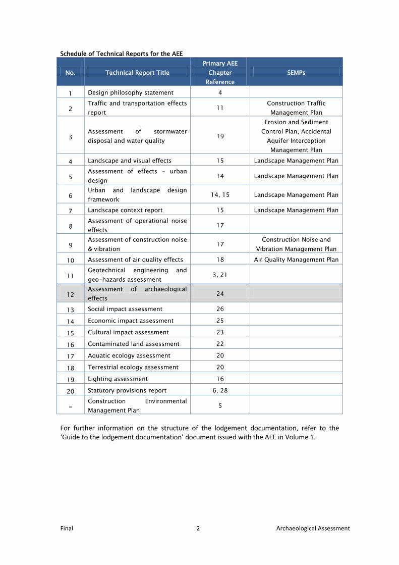
Schedule of Technical Reports for the AEE
No. Technical Report Title Primary AEE
Chapter Reference
SEMPs
1 Design philosophy statement 4
2 Traffic and transportation effects report
11 Construction Traffic Management Plan
3 Assessment of stormwater disposal and water quality
19
Erosion and Sediment Control Plan, Accidental
Aquifer Interception Management Plan
4 Landscape and visual effects 15 Landscape Management Plan
5 Assessment of effects - urban design
14 Landscape Management Plan
6 Urban and landscape design framework
14, 15 Landscape Management Plan
7 Landscape context report 15 Landscape Management Plan
8 Assessment of operational noise effects
17
9 Assessment of construction noise & vibration
17 Construction Noise and
Vibration Management Plan
10 Assessment of air quality effects 18 Air Quality Management Plan
11 Geotechnical engineering and geo-hazards assessment
3, 21
12 Assessment of archaeological effects
24
13 Social impact assessment 26
14 Economic impact assessment 25
15 Cultural impact assessment 23
16 Contaminated land assessment 22
17 Aquatic ecology assessment 20
18 Terrestrial ecology assessment 20
19 Lighting assessment 16
20 Statutory provisions report 6, 28
- Construction Environmental Management Plan
5
For further information on the structure of the lodgement documentation, refer to the ‘Guide to the lodgement documentation’ document issued with the AEE in Volume 1.
Final 3 Archaeological Assessment
EXECUTIVE SUMMARY The area affected by the Christchurch Southern Motorway Stage 2 and Main South Road Four Laning (the Project) is known to have been used by both Māori and Pākehā prior to 1900. Historical research and an archaeological survey, however, indicate that it is unlikely that any physical evidence of this pre-1900 activity will be found during the construction work for the Project. As a precaution, an authority to destroy, damage or modify an archaeological site should be sought from NZHPT prior to earthworks commencing. An accidental discovery protocol should be put in place to provide guidance on the steps to be taken if an archaeological site is found during earthworks. This has been provided as part of the draft conditions which accompany the assessment of Environmental Effects of the Project.
INTRODUCTION The New Zealand Transport Agency (the NZTA) is improving access to and from the south of Christchurch via State Highway 1 (SH1) to the Christchurch city centre and Lyttelton port, by improving the capacity, safety and alignment of the Christchurch Southern Corridor. The proposal is made up of two sections: the widening and upgrading of Main South Road (SH1) to provide for a four-lane median-separated expressway along the existing arterial route (MSRFL); and the construction, operation and maintenance of the Christchurch Southern Motorway Stage 2 (CSM2) as a four-lane separated motorway. CSM2 will link into Christchurch Southern Motorway Stage 1 (CSM1), which is currently under construction. CSM1 connects Brougham Street (SH73) in the east with Halswell Junction Road and is due to be completed in early 2013. Figure 1 below shows the study area. This assessment was commissioned by the NZTA to identify potential archaeological sites within and in close proximity to the proposed road corridors and to assess the impact of the Project on these potential sites. This assessment has been prepared in accordance with the New Zealand Historic Places Trust (NZHPT) guidelines for preparing archaeological assessments (NZHPT 2006). It is NZTA policy to use these guidelines in relation to projects it undertakes. NZHPT recommends that these guidelines be followed for archaeological assessments undertaken for both the Historic Places Act 1993 (HPA) and Resource Management Act 1991 (RMA) processes. The use of these guidelines is consistent with NZTA policy.
PROPOSAL DESCRIPTION The NZ Transport Agency (NZTA) seeks to improve access for people and freight to and from the south of Christchurch via State highway 1 (SH1) to the Christchurch City centre and Lyttelton Port by constructing, operating and maintaining the Christchurch Southern Corridor. The Government has identified the Christchurch motorway projects, including the Christchurch Southern Corridor, as a road of national significance (RoNS).
The proposal forms part of the Christchurch Southern Corridor and is made up of two sections: Main South Road Four Laning (MSRFL) involves the widening and upgrading of Main South Road (MSR), also referred to as SH1, to provide for a four-lane median separated expressway; and the construction of the Christchurch Southern Motorway Stage 2 (CSM2) as a four-lane median separated motorway. The proposed construction, operation and

Final 4 Archaeological Assessment
maintenance of MSRFL and CSM2, together with ancillary local road improvements, are referred to hereafter as ‘the Project’.
MSRFL Main South Road will be increased in width to four lanes from its intersection with Park Lane north of Rolleston, for approximately 4.5 km to the connection with CSM2 at Robinsons Road. MSRFL will be an expressway consisting of two lanes in each direction, a median with barrier separating oncoming traffic, and sealed shoulders. An interchange at Weedons Road will provide full access on and off the expressway. MSFRL will connect with CSM2 via an interchange near Robinsons Road, and SH1 will continue on its current alignment towards Templeton.
Rear access for properties fronting the western side of MSRFL will be provided via a new road running parallel to the immediate east of the Main Trunk rail corridor from Weedons Ross Road to just north of Curraghs Road. For properties fronting the eastern side of MSRFL, rear access is to be provided via an extension of Berketts Drive and private rights of way.
The full length of MSRFL is located within the Selwyn District.
CSM2 CSM2 will extend from its link with SH1 / MSRFL at Robinsons Road for approximately 8.4 km to link with Christchurch Southern Motorway Stage 1(CSM1, currently under construction) at Halswell Junction Road. The road will be constructed to motorway standard comprising four lanes, with two lanes in each direction, with a median and barrier to separate oncoming traffic and provide for safety.1 Access to CSM2 will be limited to an interchange at Shands Road, and a half-interchange with eastward facing ramps at Halswell Junction Road. At four places along the motorway, underpasses (local road over the motorway) will be used to enable connectivity for local roads, and at Robinsons / Curraghs Roads, an overpass (local road under the motorway) will be provided. CSM2 will largely be constructed at grade, with a number of underpasses where elevated structures provide for intersecting roads to pass above the proposed alignment.
CSM2 crosses the Selwyn District and Christchurch City Council boundary at Marshs Road, with approximately 6 km of the CSM2 section within the Selwyn District and the remaining 2.4 km within the Christchurch City limits.
Key design features The key design features and changes to the existing road network (from south to north) proposed are:
• a new full grade separated partial cloverleaf interchange at Weedons Road;
• a new roundabout at Weedons Ross / Jones Road;
• a realignment and intersection upgrade at Weedons / Levi Road;
• a new local road running to the immediate east of the rail corridor, to the west of Main South Road, between Weedons Ross Road and Curraghs Road;
1 CSM2 will not become a motorway until the Governor-General declares it to be a motorway upon request from the NZTA under section 71 of the Government Roading Powers Act 1989 (GRPA). However, for the purposes of this report, the term “motorway” may be used to describe the CSM2 section of the Project.
Final 5 Archaeological Assessment
• alterations and partial closure of Larcombs Road intersection with Main South Road to left in only;
• alterations to Berketts Road intersection with Main South Road to left in and left out only;
• a new accessway running to the east of Main South Road, between Berketts Road and Robinsons Road;
• an overpass at Robinsons and Curraghs Roads (the local roads will link under the motorway);
• construction of a grade separated y-junction (interchange) with Main South Road near Robinsons Road;
• a link road connecting SH1 with Robinsons Road;
• a short new access road north of Curraghs Road, adjacent to the rail line;
• a new roundabout at SH1 / Dawsons Road / Waterholes Road;
• an underpass at Waterholes Road (the local road will pass over the motorway);
• an underpass at Trents Road (the local road will pass over the motorway);
• the closure of Blakes Road and conversion to two cul-de-sacs where it is severed by CSM2;
• a new full grade separated diamond interchange at Shands Road;
• an underpass at Marshs Road (the local road will pass over the motorway);
• providing a new walking and cycling path linking the Little River Rail Trail at Marshs Road to the shared use path being constructed as part of CSM1;
• an underpass at Springs Road (the local road will pass over the motorway);
• a new grade separated half interchange at Halswell Junction Road with east facing on and off ramps linking Halswell Junction Road to CSM1; and
• closure of John Paterson Drive at Springs Road and eastern extension of John Paterson Drive to connect with the CSM1 off-ramp via Halswell Junction Road roundabout (east of CSM2).
The proposed alignment is illustrated in Figure 1 and encompasses the MSRFL and CSM2 alignments between Rolleston and Halswell Junction Road.
Earthworks methodology The Project will involve reasonably large volumes of earthworks. The Project will generate approximately 405,000m3 of excavated (cut) material (excluding topsoil) with approximately 320,000m3 of this cut material suitable to be placed for fill embankments. Approximately 1,035,000m3 of fill will be required for the Project of which approximately 715,000m3 will be imported fill, approximately 300,000m³ of topsoil will be stripped and stockpiled for reuse on site. This fill material will be sourced locally, potentially some of this volume from suitable demolition material as a result of the recent Christchurch earthquakes or from local quarries or the Waimakariri River.

Final 6 Archaeological Assessment
Cut slopes Cut slopes will be minimal, generally up to 2.9 m in height with shallow cut slopes of 4h:1v. The only exception will be the Robinsons-Curraghs link which passes under MSR in a 7 m deep cutting. Cut material will be excavated mechanically and will be stockpiled or loaded directly onto trucks to be transported for use elsewhere on the Project. Fill embankments The fill embankment slopes, typically up to 8 m in height (but a maximum of 10.5 m high), will be formed from materials sourced from cuttings but predominately from imported fill, which is likely to include selected earthquake demolition material.

Final 7 Archaeological Assessment
Figure 1 Proposal location map and Study area

Final 8 Archaeological Assessment
STATUTORY FRAMEWORK
Historic Places Act The HPA provides protection for archaeological sites and is administered by the NZHPT. Under section 2 of the HPA, an archaeological site is defined as:
“…any place in New Zealand that – (a) Either –
(i) Was associated with human activity that occurred before 1900; or (ii) Is the site of the wreck of any vessel where that wreck occurred before 1900; and
(b) Is or may be able through investigation by archaeological methods to provide evidence relating to the history of New Zealand.”
Under the HPA, anyone who wishes to destroy, damage or modify an archaeological site requires an authority to do so under sections 11 or 12 of the HPA. It is illegal to destroy, damage or modify an archaeological site without an authority from the NZHPT. The HPA allows NZHPT up to 3 months to make a decision on the authority application, after the application has been lodged (the authority application will be lodged within 10 working days of being received, if all the required information is present). If granted, an authority has a life of up to five years. An authority may be granted with conditions, such as archaeological survey, monitoring and/or excavation. Any archaeologist carrying out work as a condition of the authority must be approved by the NZHPT under section 17 of the HPA. Once the authority has been granted, there is a statutory 15 working-day stand down period before earthworks can begin. This is one of the standard conditions of an archaeological authority. Summary of the timeframes associated with applying for an archaeological authority:
• Following lodgement of the application, the NZHPT has 3 months to process the application.
• After the authority has been granted, there is a statutory 15 working day stand-down period before earthworks can begin. This is to allow for appeals regarding the authority decision to be lodged.
Resource Management Act The NZTA proposes to lodge its application with the Environmental Protection Authority (EPA) to obtain the necessary authorisations under the (RMA) to enable the Project. The NZTA seek regional resource consents and confirmation of Notices of Requirement (NoRs) from the EPA. The lodgement documentation will include an assessment of environmental effects that will consider any actual or potential effects on heritage and archaeology. The technical report will be provided with the AEE. The 2003 amendments to the RMA strengthen the recognition of historic heritage in the RMA by including the protection of historic heritage as a matter of national importance. The amendments included the addition of a definition of “historic heritage”. Section 6 of the RMA (matters of national importance) shall recognise and provide for the following matters of national importance: “(f) the protection of heritage from inappropriate subdivision, use, and
development.”

Final 9 Archaeological Assessment
‘Historic heritage’ is defined as: “(a) …those natural and physical resources that contribute to an understanding and
appreciation of New Zealand’s history and cultures, deriving from any of the following qualities:
(i) archaeological: (ii) architectural: (iii) cultural: (iv) historic: (v) scientific: (vi) technological: and
(b) includes - (i) historic sites, structures, places, and areas; and (ii) archaeological sites; and (iii) sites of significance to Maori, including wahi tapu; and surroundings
associated with the natural and physical resources.”
METHODOLOGY Historical research was carried out to determine the potential for archaeological sites to be encountered during the earthworks required for the Project. This research focused on the area shown in Figure 1 and thus considered a larger area than will be directly affected by the proposed works. Potential archaeological sites were then inspected by me during an archaeological survey. The following sources were consulted to determine potential archaeological sites within the road corridors:
• ArchSite; • Landonline; • the New Zealand Historic Places Trust Register; • the Christchurch City Plan; • the Selwyn District Plan; • aerial photographs; • reports relating to the European and Māori heritage in the area covered by the
South-West Area Plan (Ohs and Lovell-Smith 2008, Pearson et al. 2008 and Tau n.d.);
• Maling’s Historic Charts and Maps of New Zealand 1642-1872; and • various secondary sources, including Beyond the City, The Paparua County and
Paparua County Council. No landowners were spoken to during the course of this work and nor were tangata whenua. The archaeological survey was carried out on 2 April 2012. A meeting was held with Historic Places Trust on 7 August 2012 to discuss archaeological research results, authority information requirements and obtain confirmation that all known sites have been identified.

Final 10 Archaeological Assessment
HISTORICAL BACKGROUND Māori are known to have used this general area, when they carried their waka between the headwaters of the Heathcote and Halswell rivers (roughly in the area of Owaka Road) as they journeyed between the settlements around Christchurch and Banks Peninsula/Lake Ellesmere. Tau (n.d.) records the presence of two mahinga kai near Rolleston, but the exact location of these is not known (H. Brown, pers. comm.). The waterholes at Templeton are marked on an early European map as Ruapuna, indicating that Māori knew of the existence of these, and no doubt used them (McBride 1990: 16). The first European use or occupation of the land between Prebbleton and Templeton came with the take up of runs in the early 1850s. The available information makes it difficult to determine exactly which runs covered the area in question but Coringa appears to have done so, and Prebble’s run may also have covered part of the area (Figure 2). Runs 27 and 102 made up Coringa and were taken up by Charles Church Haslewood in May 1852 and August 1853 respectively. Each run was of 5000 acres. Haslewood died in 1858 after an unfortunate accident while cleaning his gun and the station, of 15,000 acres, was sold to Edward Merson Templer. By 1865 much of the station’s land had been freeholded. The remaining 4000 acres were renumbered as Run 136, a Class II run. Templer sold Coringa to George Gatenby Stead in 1882. Stead owned the property until his death in 1908. In 1946 there was still a Coringa farm, which included 800 acres of riverbed leasehold (presumably on the Waimakariri river). Coringa was notable for being the site of the first known public sheep dip in Canterbury (Acland 1975: 34-35). Run 10, which was known as Prebble’s run, was taken up by William James Prebble. Prebble squatted on the land from 1847, and the run, of 5000 acres, was subsequently officially granted to him. In his application for the land, Prebble noted that he (along with his brother, Richard) already had 50 cows, two bulls and a horse grazing there (Scotter and Loach n.d.: 14). The Prebbles undertook some work on their land, building a one mile long sod wall on the northern boundary. A track from this boundary led to the city and was initially known as ‘Prebble’s’. After it was extended towards The Springs run it became known as ‘Springs Track’. More than half the run had been purchased as freehold by 1856, and most of the remainder had been purchased by 1865, although William Prebble retained sufficient land to farm in the area. Prebble owned this farm until 1883 (Acland 1975: 58).

Final 11 Archaeological Assessment
Figure 2 The runs taken up in the immediate vicinity of Christchurch. From Penney 1977: 20.
The proximity of Coringa and Prebble’s run to the burgeoning settlement of Christchurch lay behind the rapid freeholding of the land, as new settlers sought to establish small farms of their own. The increasing density of settlement in the area led to the development of roads, with Springs Road and what would eventually become the current State Highway 1 surveyed by 1866 (see Maling 1999: 251). Closer settlement also led to the construction of a railway line from the city to Rolleston. This line was completed in 1866, at which time the following description of the country between Christchurch and Rolleston was published:
Little farm homesteads follow on either side of the line for some seven miles from the city, affording abundant proof of the value of a railway as inducing cultivation of land along its route. These farms have all sprung into being since the line was surveyed, or within the last two years. In general, these holdings present a barren aspect, but little having been done in the way of tree planting. But at intervals we passed charming homesteads nestling amid weeping willows and poplars in all the freshness of their spring foliage… The lands of the stock and dairy farmers were enclosed in permanent fences of gorse up to (Weedons) and the paddocks were rapidly assuming the greenness of English grasses which showed a marked contrast to the scorched appearance of the native pastures on the unimproved land. From McBride 1990: 13.
Within a decade another railway line had been built through the area. This was the Southbridge branch, which ran from Hornby to Southbridge. The line was built to service the increasing number of crop farms in the district, enabling farmers to get their product to market efficiently. The line opened on 13 July 1875. The stations along the line were at Southbridge, Doyleston, Ellesmere and Prebbleton (Bromby 2003: 84). The line carried

Final 12 Archaeological Assessment
passengers until 12 April 1951. By December 1967 only a small section of line was operational, between Hornby and Prebbleton. This is still used and is known as the Hornby Industrial Line (Churchman 1990: 183). Templeton, named for Edward Templer, developed around an area known as Waterholes, on account of the springs in the area. This reliable water supply meant that bullock wagon trains often camped here for the night. The first freehold purchase (a block of 50 acres) in this area was by Arthur Charles Knight and included the waterholes. The waterholes lay to the south of the Great South Road and Templer purchased 100 acres freehold out of his run (Coringa) on the other side of the road in 1860, later adding 75 acres to this holding (in 1862). In 1863 Templer donated two acres for a school, which had opened by the end of 1863, and around which the settlement of Templeton grew, although town sections were not surveyed off until 1877 (McBride 1990: 16-18). Most of the land around Templeton, and Prebbleton, has been rural since the arrival of Europeans, although more recent years have seen the development of commercial areas. One interesting industry in the area in the 19th century was Trent’s chicory farm, which was in the southern part of the study area. This farm was established in 1866 and by the early 1870s there was a substantial complex at the farm, which reflected the success of William Trent’s business.2
PREVIOUS ARCHAEOLOGICAL WORK The footprint of CSM2 has not previously been the subject of an archaeological survey, nor are there any recorded archaeological sites within the footprint of the scheme (see below).3 Further, there are no Christchurch City Council or Selwyn District Council-listed or NZHPT-registered buildings or structures within the designation footprint. This was confirmed by NZHPT. There are seven recorded archaeological sites within the broad area between Lincoln, Rolleston, Templeton and Prebbleton (Figure 3), none of which are affected by the Project. The sites are two middens/ovens (M36/34 and M36/37), three historic houses (M36/164, M36/226 and M36/227), a religious institution (M36/237) and an agricultural/pastoral site of undefined type (M36/208). The two midden/oven sites are indicative of Māori activity in the area in the past. Of these sites, the closest to CSM2 are M36/226 (which was destroyed during construction works for CSM1) and M36/37, which is 55 m from the construction corridor for CSM2.
2 http://christchurchcitylibraries.com/heritage/localhistory/industry/chicory/. 3 CSM1 was the subject of an archaeological survey carried out by Opus International Consultants in 2007.

Final 13 Archaeological Assessment
Figure 3 Recorded archaeological sites in the vicinity of the study area with overlay of road corridor. Image from ArchSite.
RESEARCH RESULTS The archaeological research revealed just one potential archaeological site within or adjacent to the road corridor. This was the only site inspected during the archaeological survey. This was a shed shown on SO 8723 (1954; Figure 4), but not on any earlier plans of the area. Figure 4 Part of SO 8723 (1954), showing a shed.

Final 14 Archaeological Assessment
Shed The shed shown on Figure 4 remains standing, but is outside the designation footprint described in the NoRs (Figures 5 and 6). (Construction areas for the Project will be located entirely within the designation footprint, and thus the shed will not be affected.) Figure 5 The same area as shown in Figure 4. Image from Google Earth.
Figure 6 The location of the shed in relation to the CSM2 alignment and designation footprint.
Final 15 Archaeological Assessment
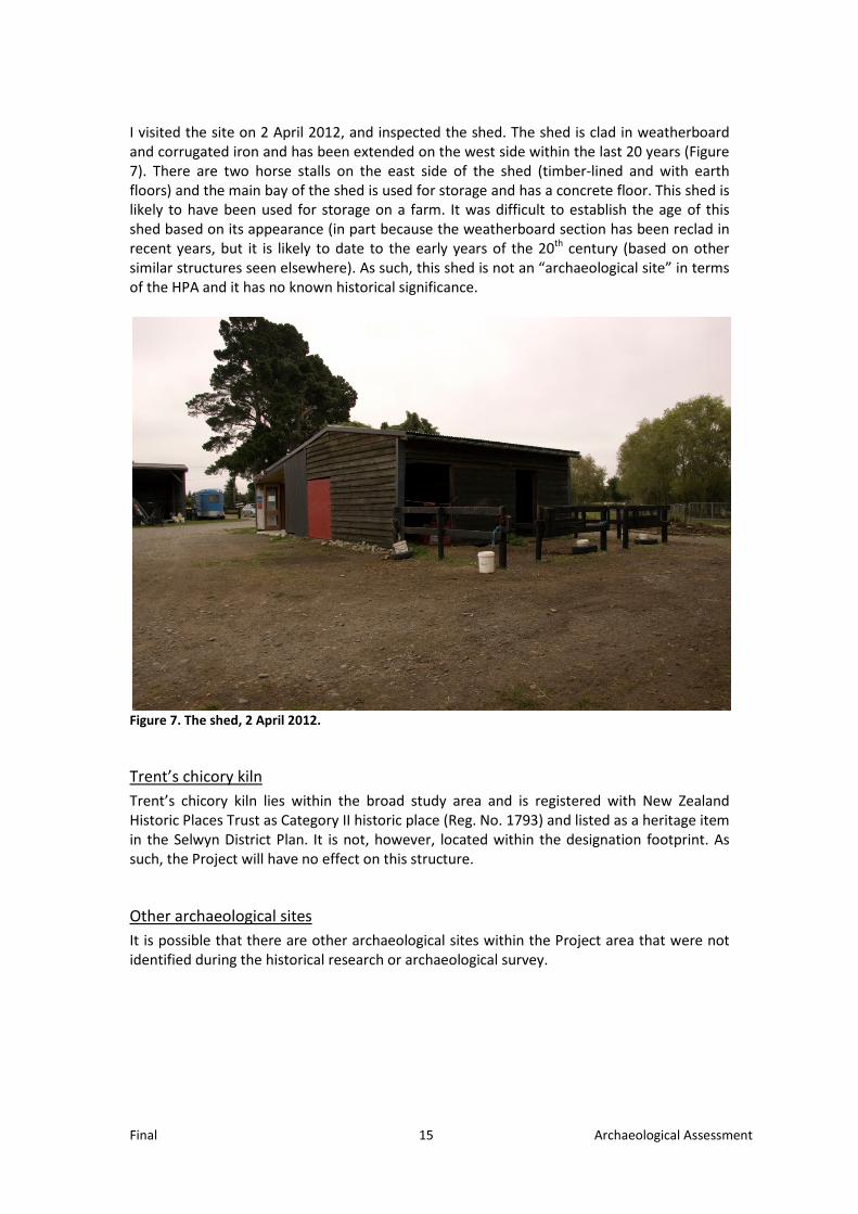
I visited the site on 2 April 2012, and inspected the shed. The shed is clad in weatherboard and corrugated iron and has been extended on the west side within the last 20 years (Figure 7). There are two horse stalls on the east side of the shed (timber-lined and with earth floors) and the main bay of the shed is used for storage and has a concrete floor. This shed is likely to have been used for storage on a farm. It was difficult to establish the age of this shed based on its appearance (in part because the weatherboard section has been reclad in recent years, but it is likely to date to the early years of the 20th century (based on other similar structures seen elsewhere). As such, this shed is not an “archaeological site” in terms of the HPA and it has no known historical significance.
Figure 7. The shed, 2 April 2012.
Trent’s chicory kiln Trent’s chicory kiln lies within the broad study area and is registered with New Zealand Historic Places Trust as Category II historic place (Reg. No. 1793) and listed as a heritage item in the Selwyn District Plan. It is not, however, located within the designation footprint. As such, the Project will have no effect on this structure.
Other archaeological sites It is possible that there are other archaeological sites within the Project area that were not identified during the historical research or archaeological survey.

Final 16 Archaeological Assessment
ARCHAEOLOGICAL VALUES The NZHPT4 recommends considering the following when assessing the values of an archaeological site:
• condition; • context; • rarity; • information potential; • cultural associations; and • amenity values.
No known archaeological sites will be impacted by the Project. As such, no assessment of archaeological values has been undertaken.
HERITAGE VALUES The shed identified during the archaeological research has no known heritage values as the history of the shed is not known, it has no distinguishing architectural values, no scientific/technical merit and no known cultural values.
ASSESSMENT OF EFFECTS The NZHPT recommends considering the following matters when assessing the effects of a proposal on an archaeological site:
• How much of the archaeological site will be affected, to what degree and what effect will this have on the archaeological site’s values?
• Will the proposed work increase the risk of future damage to the archaeological site?
• Would a redesign reduce the effects of the proposed work? • What methods could be used to avoid, minimise or mitigate any adverse
effects?
How much of the site will be affected? No known archaeological or heritage sites will be affected by the proposed work. The seven recorded archaeological sites and one known heritage site (the chicory kiln) are all located outside the land described for the designation footprint. Construction areas and site access will all be contained within the land proposed for designation, avoiding any adverse effects on the known archaeological and heritage sites. Given the distance of the sites from the proposed alignment (the closest extant site M36/37, is 55 m from the alignment), any minor adjustment of the alignment is unlikely to adversely affect any site, either in terms of disturbance or adverse visual impacts. The one potential archaeological site identified during the research is not an “archaeological site” as defined by the HPA and has no known historical significance.
4 NZHPT, Archaeological Guidelines Series No 2 - Guidelines for Writing Archaeological Assessments, 2006

Final 17 Archaeological Assessment
Future damage The proposed work will not increase the risk of future damage to any known archaeological sites.
Redesign The Project has avoided all known archaeological sites and thus a redesign would not reduce the effects of the work on known archaeological sites.
Mitigation The Project will not affect any known archaeological or heritage sites. Therefore no mitigation work will be required. It is possible that archaeological sites that have not been identified during this assessment could be exposed during earthworks for the Project, such as middens, ovens, Māori occupation sites, building sites and/or rubbish dumps. In order to manage this possibility, the accidental discovery protocol drawn up by Te Runanga o Ngai Tahu, Transit (now the NZTA) and the New Zealand Historic Places Trust will be put in place (see Appendix 1 for an example accidental discovery protocol), and all contractors involved in earthworks will need to be briefed on the accidental discovery protocol and to receive training in the recognition of an archaeological site. This is consistent with NZTA policy. If archaeological sites are exposed during the earthworks, they will need to be excavated, recorded and analysed in accordance with standard archaeological techniques. NZHPT is likely to require that an archaeological management plan is prepared as a condition of the authority. The exact requirements of the management plan will be determined by NZHPT but are likely to include details about where and when monitoring and site briefings are required, procedures and protocols for any stand-down periods for archaeological work to take place, the role and level of authority of the archaeologist and procedures for dispute resolution.
DISCUSSION AND CONCLUSION No archaeological sites within the road corridor of CSM2 or MSRFL have been identified, although there is a history of both Māori and European use of the area. Given that it is possible that archaeological sites not identified during this assessment could be exposed during earthworks for the Project, an authority to destroy, damage or modify an archaeological site should be sought from the NZHPT prior to earthworks commencing. This will avoid any delays during construction, should an archaeological site be exposed. An accidental discovery protocol should be included in the conditions to manage the possibility of exposing a previously unrecorded archaeological site.
Final 18 Archaeological Assessment
BIBLIOGRAPHY Acland, L. G. D., 1975. The Early Canterbury Runs. 4th edition. Whitcoulls, Christchurch. Bromby, Robin, 2003. Rails that Built a Nation: an encyclopaedia of New Zealand railways.
Grantham House, New Zealand. Churchman, Geoffrey and Hurst, Tony, 1993. The Railways of New Zealand: a journey
through history. Transpress New Zealand, Wellington. Maling, P. B., 1999. Historic Charts and Maps of New Zealand 1642-1875. Reed Books,
Auckland. McBride, Ian, 1990. The Paparua County: a concise history. Christchurch: Canterbury Public
Library. Ohs, Amanda and Lovell-Smith, Margaret, 2008. South-West Christchurch Area Plan. Phase 1
Report – European Cultural Heritage. Unpublished report prepared for Christchurch City Council.
New Zealand Historic Places Trust, 2006. Guidelines for writing archaeological assessments.
Archaeological Guidelines Series No. 2. New Zealand Historic Places Trust, Wellington.
Pearson, Lizzy, Oliver, Sarah, Lilley, Sarah, Pauling, Craig, Hullen, Joseph and Lenihan, Te
Marino, 2008. South-West Christchurch Area Plan. Phase 1 Report – Tangata Whenua Values. Unpublished report prepared for Christchurch City Council.
Penney, Sarah E. W., 1977. Beyond the City: the land and its people: Riccarton, Waimairi,
Paparua. Penney Ash Publications, Christchurch. Scotter, W. H. and Loach, A. C., 1973. Paparua County Council: county history
(uncompleted). Unpublished (held at Christchurch City Library).

Final 19 Archaeological Assessment
APPENDIX A: ACCIDENTAL DISCOVERY PROTOCOL