Chris Pearson National Geodetic Survey Chris.Pearson@noaa ...
32
Introduction to NGS CORS and OPUS Chris Pearson National Geodetic Survey [email protected], (217) 524-2890
Transcript of Chris Pearson National Geodetic Survey Chris.Pearson@noaa ...

Introduction to NGS CORS and OPUS
Chris PearsonNational Geodetic Survey
[email protected], (217) 524-2890

Key web addresses for CORS and OPUS
•CORS– http://www.ngs.noaa.gov/CORS/
•OPUS– http://www.ngs.noaa.gov/OPUS/
•OPUS DB– http: //beta.ngs.noaa.gov/OPUS/– http://www.ngs.noaa.gov/OPUS/

CONTINUOUSLY OPERATING REFERENCE STATIONS (CORS)
1300+ Installed and Operated byvarious Federal-State-local Agencies
NOAA/National Geodetic SurveyNOAA/OAR Global Systems DivisionU.S. Coast Guard - DGPS/NDGPSCorps of Engineers - DGPSFAA - WAAS/LAAS State DOTs County and CityAcademiaPrivate Companies

CORS Network Evolution1994 - 2008
1994 1997 2000
2003 2006 2008

Map
• 1,350 CORS sites (09/09)• ~ 200 organizations• 200 new sites in FY09

Illinois CORS
ILUC UIUC SCCB


Baseline Plot National

• ITRF (yyyy) International Terrestrial Reference Frame
• All coordinates change to reflect tectonic motion
• NAD83 –in stable North American coordinates are constant
• In the far west coordinates not constant so epoch dates are important
ITRF00
NAD83

HB 1
HB 2
HB 3
HB 4
HB 5
HB8HB 9
HB16HB 17
FL
GA AL MS
HB 18
NC SC
HB 19
HB 32
HB 33
HB10
HB11
HB 20
HB 21
HB 22
HB 23
HB 6
HB 7
HB 12
HB 13
HB 24
HB 25
HB 26
HB 27
HB 14
HB15
HB28
HB 29
HB 30
HB 31
HB 34
HB 35
HB 36
HB 37
HB 38
HB 39
HB 40
HB 41
HB 42
HB 43
HB 44
HB 45
HB 46
HB 47
HB 48
HB 49
HB 50
HB 51
OR WA CA AK PR VQ
VA WV MD PA DC DE NY NJ CT MA ME NH RI VT LA AR TN KY MO IL IN OH MI WI MN IA ND SD NE KS OK TX NM AZ CO UT NV ID MT WY
HELMERT BLOCKING STRATEGY
This is how each state fits into the National Readjustment
CORS
Control for the NSRS2007 adjustment
CORS were held fixed provided control at the top block

•Precise (Final)•14 days latency•1 cm accuracy•updated weekly
•Rapid•1 day latency•2 cm accuracy•updated daily
•UltraRapid•24 hrs observed / 24 hrs predicted•5 cm / 10 cm accuracy•updated 4 times/day
NGS/IGS PRECISE ORBITS

Broadcast orbits• Only 4 control stations
– All located in the tropics– Accuracy 2.5 m

Data available for each site
• Coordinates ITRF and NAD83• Datasheet ARP and phase center• Data availability (was it working
during my project)• Site Log Antenna and receiver• File downloads (Standard and UF• Time series

CORS time series
• CORS processing gives a new coordinate every day• We can estimate velocities by following the trend• The height is al ellipsoid heights rather than orthometric heights• Because of local changes CORS coordinates do not always reflect the
time series
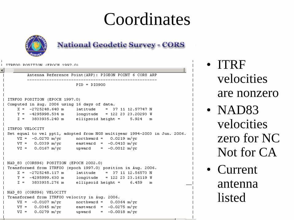
Coordinates
• ITRF velocities are nonzero
• NAD83 velocities zero for NC Not for CA
• Current antenna listed
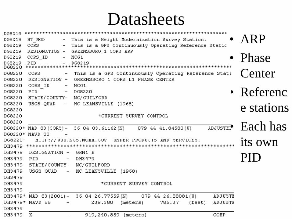
Datasheets• ARP• Phase
Center• Referenc
e stations• Each has
its own PID

Site log
• Receiver and antenna
• Lists every one ever installed on this site

Data availability

Standard files
• RINEX– GPS OBS
• Navigation– Broadcast
orbits• IGS
Ephemeris– High
accuracy orbits
• Rapid Ephemeris– Predicted
high accuracy orbits

User friendly CORS

http://www.ngs.noaa.gov/OPUS
You’ve got mail!
OPUS solution

Static: OPUS determines your position with a differential GPS static solution, using hours of data.
This process is repeated twice from other CORS.

XB
A
X
C
XA
XCB
How accuracies of OPUS coordinates are estimated
Rover
• Each OPUS solution uses 3 CORS
• As a result there are 3 independent baselines and 3 independent estimates of the coordinates
• The coordinates that OPUS gives are an average of the three values
• The errors are just the maximum difference between the three values
misclose

Rapid-static: OPUS first creates an atmospheric delay model from surrounding CORS data.
Your position is then quickly determined by differential GPS static solution.

Methodology – Rapid-Static Algorithm
Rover solution schemes
: 0: 0
ABX AB XB XA XB XA ABACX AC XC XA XC XA AC
ΔΔ
− + = → = +− + = → = +
B
A
X
NetworkC
A
X
RoverC
AC
AB XA
XBXC
B
AB
AC
All three CORS stations contribute to the estimation of a single set of ambiguities
One unknown baseline
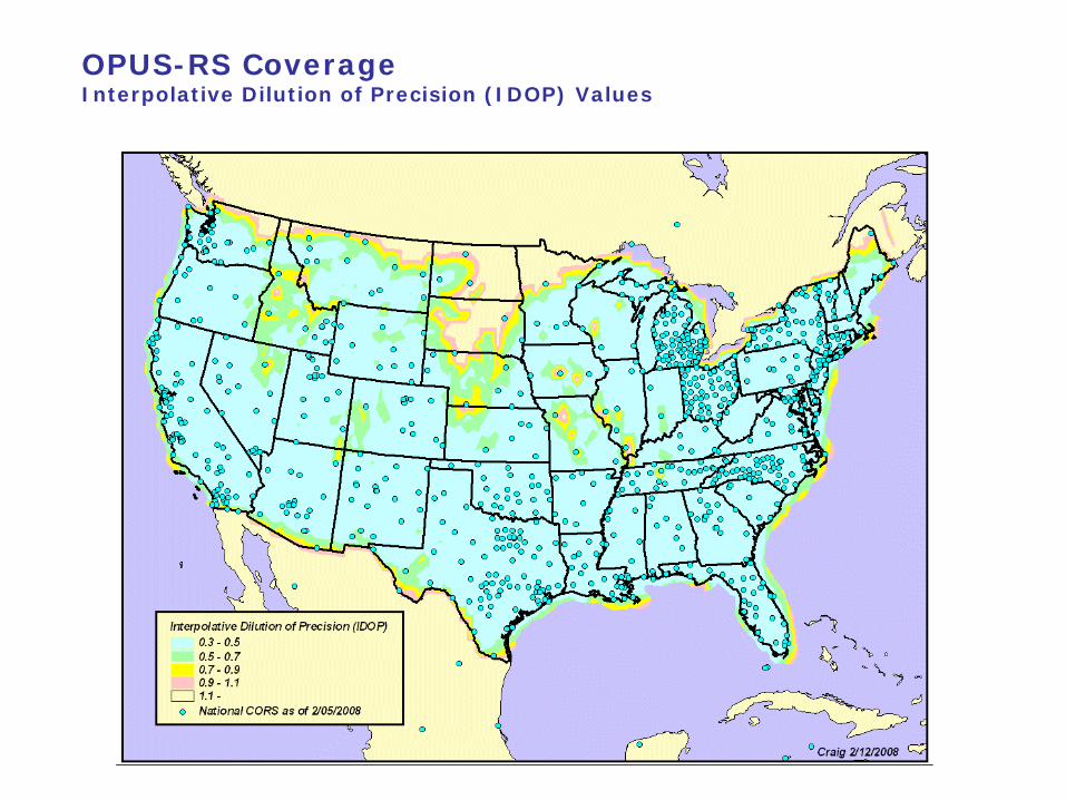
OPUS-RS CoverageInterpolative Dilution of Precision (IDOP) Values

control stationphoto *
control station description *
control station monument
NGS-modeled antenna
GPS data (4+hours)
OPUS websitehttp://geodesy.noaa.gov/OPUS
for registered users
publicdatasheet
QA/QC2
reviews
OPUS Datasheet Concept
observationnotes
*optional for “existing” stations.

GPS data requirements
“OPUSable”4+ hours of dual frequency dataNGS-calibrated antennaOPUS must achieve:
≥ 90% observations used≥ 80% ambiguities fixed≤ 0.02m peak-to-peak horizontal≤ 0.04m peak-to-peak vertical
NGS-modeled antenna
GPS data (4+hours)

*optional for “existing” stations.
control station description *
control stationphoto *
metadata requirements
observationnotes
Simplified bluebooking

Submit data to OPUS-DB- Only STATIC please


OPUS statistics checked by computerPhotos reviewed by NGSDatasheet reviewed by agency
QA/QC2
reviews
quality control