Chien-Ben Chou and Huei-Ping Huang Central Weather Bureau ... · Case study: Typhoon Sinlaku...
21
The impact of assimilating AIRS observations on the forecast of typhoon tracks Chien-Ben Chou 1 and Huei-Ping Huang 2 1 Central Weather Bureau, Taipei, Taiwan 2 School for Engineering of Matter, Transport, & Energy, Arizona State University
Transcript of Chien-Ben Chou and Huei-Ping Huang Central Weather Bureau ... · Case study: Typhoon Sinlaku...

The impact of assimilating AIRS observations on the forecast of typhoon tracks
Chien-Ben Chou1 and Huei-Ping Huang2
1Central Weather Bureau, Taipei, Taiwan2School for Engineering of Matter, Transport, & Energy, Arizona State University

Conventional observations are sparse over the ocean
Satellite data are particularly useful for "filling the gap" over the ocean ⇒ Useful for the prediction of typhoons/hurricanes (e.g., Zhang et al. 2007, Chou et al. 2008, Goerss 2009)
How the inclusion of satellite obs would impact the forecast depends on the tuning of the data assimilation procedure (e.g., 3DVAR). This fact is in the back of the minds of practitioners but is not often systematically explored.

Case study: Typhoon Sinlaku (September 2008)
(Wikipedia open source; background photo from NASA)

Forecast experiments
● Use Weather Research & Forecast (WRF) model Two-layer nesting (outer domain = 45 km, inner domain = 15 km res.) 23 vertical levels
● Control run (w/o AIRS) vs. Runs that assimilate AIRS observation ⇧ Initialized with short-term NCEP GFS global forecast
● Use standard 3DVAR in WRF for data assimilation
The default parameter setting in the 3DVAR procedure was for the assimilation of sparsely distributed conventional sounding. We will tune the parameters away from the default (effectively changing the weight given to the satellite obs) as a sensitivity test.

● Use AIRS v5 quality-controlled Level 2 data only. Both temperature and moisture profiles are used.
Data near the center of a typhoon is rejected, but the addition of satellite data can still be useful: The interaction of the outflow of a typhoon and the large-scale environment is important for the movement (track) of the typhoon. Thus, we focus on the forecast of the track.
● Effective resolution of the AIRS/AMSU data is ~ 40 km (a satellite "sounding" represents 9 AIRS field-of-views within a single AMSU-A footprint)
● The estimated observation error for AIRS is close to the default observation error in WRF 3DVAR (which was set for conventional sounding). For example, the obs error for tropospheric temperature is ~ 1 °K. As such, for simplicity we keep the WRF default in our experiments.

● The observation error of AIRS is assumed to be spatially independent. (The error covariance matrix is diagonal.)
● The observation error of AIRS data and the background error are also assumed to be independent. Further detail in Chou and Huang (2011)

850 hPa temperature 500 hPa temperature
WRF model domains: Outer: 45 km, Inner: 15 km

Sensitivity test
● Varying 2 parameters in 3DVAR: LEN_SCALING: controls the spatial decorrelation length scale, LB, of background error VAR_SCALING: controls the "amplitude" of background error covariance Varying these parameters would control how much information in the satellite obs is accepted into the initial state For example, structures with L < LB are severely smoothed. Increasing LEN_SCALING would kill small-scale features in satellite obs which might otherwise be real
● WRF 3DVAR default: LEN_SCALING = 1, VAR_SCALING = 1. Sensitivity test will cover the range of LEN_SCALING = 0.1-1, VAR_SCALING = 0.1-1.
● While (LEN_SCALING, VAR_SCALING) can be adjusted individually for the 5 variables in 3DVAR (streamfunction, velocity potential, temperature, humidity, and surface pressure), for simplicity we always use the same parameter values for all 5 variables.
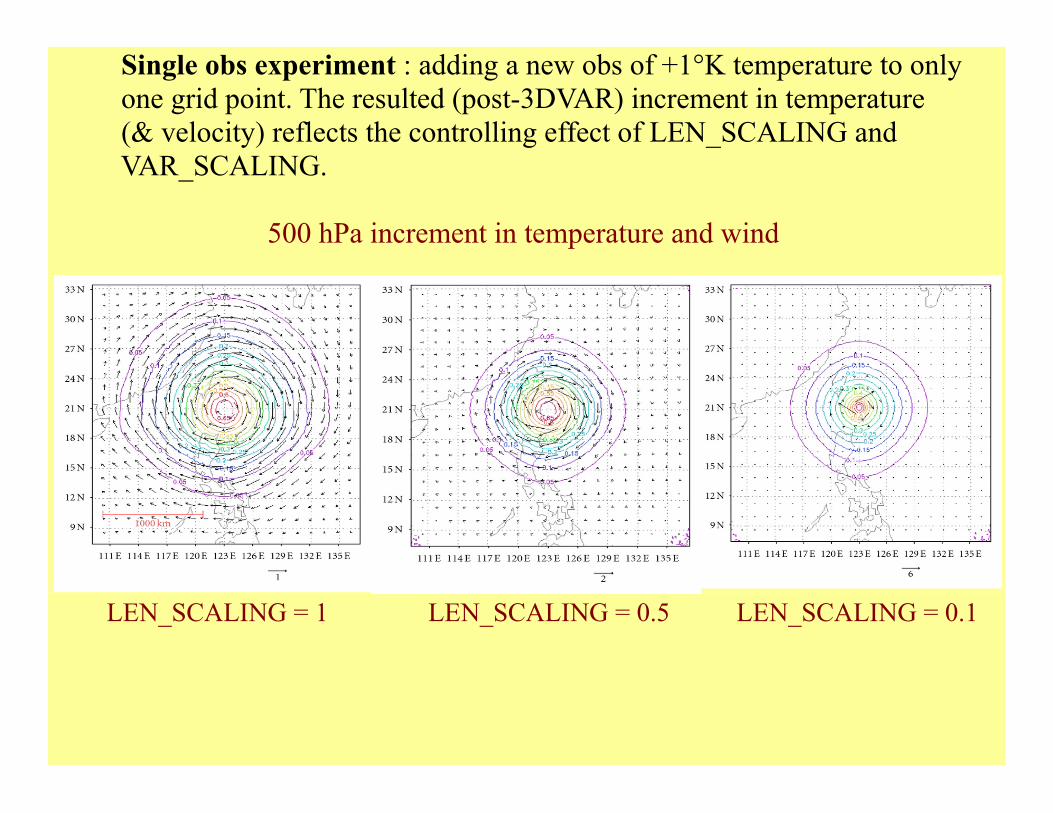
Single obs experiment : adding a new obs of +1°K temperature to only one grid point. The resulted (post-3DVAR) increment in temperature (& velocity) reflects the controlling effect of LEN_SCALING and VAR_SCALING.
500 hPa increment in temperature and wind
LEN_SCALING = 1 LEN_SCALING = 0.5 LEN_SCALING = 0.1

Forecast of track for typhoon Sinlaku
96-hr forecast from Sept 11, 2008, 1800 UTC
LEN_SCALING = 1, VAR_SCALING = 0.1-1 step 0.1
Black = control Red = Runs with AIRS Blue = Observation ("best track")
VAR_SCALING

LEN_SCALING = 0.5, VAR_SCALING = 0.1-1 step 0.1
VAR_SCALING

LEN_SCALING = 0.1, VAR_SCALING = 0.1-1 step 0.1
VAR_SCALING

● Assimilation of AIRS obs leads to a correction of the predicted typhoon track that is qualitatively in the right direction.
● Quantitatively, the benefit of including AIRS obs depends on the detailed setup of the 3DVAR procedure
We find it beneficial to tune LEN_SCALING down from the WRF default designed for conventional sounding. This allows smaller-scale structures in satellite obs (which can be real!) to pass through 3DVAR.

Nevertheless, as we allow structures with smaller and smaller scales in the satellite obs (of temperature) to go through 3DVAR, the increment in the velocity field can become very large. (Indeed, we see this happening in the cases with sufficiently small LEN_SCALING and large VAR_SCALING.) This is likely because gradient wind balance is used to convert temperature to velocity (which satellite obs does not provide) but that balance is no longer valid at small scales.
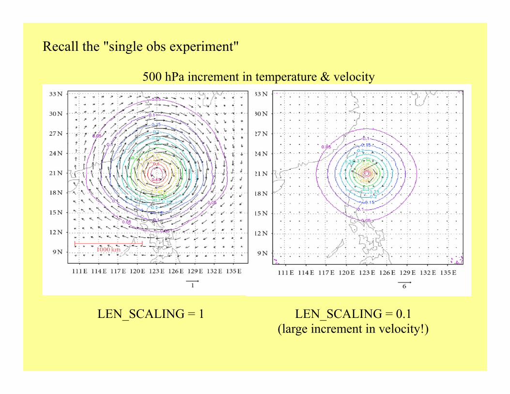
Recall the "single obs experiment" 500 hPa increment in temperature & velocity
LEN_SCALING = 1 LEN_SCALING = 0.1 (large increment in velocity!)

Concluding remarks
● Encouraging evidence that the assimilation of AIRS data helps improve the forecast of typhoon track
● Important to tune the data assimilation procedure for it to properly accommodate the satellite data. Much still needs to be done to explore this aspect.

Extra: Comparison of AIRS and dropsonde observation

2011/10/20

Clear sky case (site 3, 2011/10/20 4:49)
JMAanalysis
NCEPanalysis
AIRS
Black = dropsonde
TTd

2011/10/25

Cloudy sky case (site 6, 2011/10/25 5:31)
AIRS JMAanalysis
NCEPanalysis
Black = dropsonde
T
Td