Chesapeake Quarterly Volume 10 Number 1
16
CHESAPEAKE QUARTERLY CHESAPEAKE QUARTERLY The Bays Beneath the Bay MARYLAND SEA GRANT COLLEGE • VOLUME 10, NUMBER 1 The Bays Beneath the Bay
Transcript of Chesapeake Quarterly Volume 10 Number 1

CHESAPEAKEQUARTERLYCHESAPEAKEQUARTERLY
The Bays Beneath
the Bay
MARYLAND SEA GRANT COLLEGE • VOLUME 10, NUMBER 1
The Bays Beneath
the Bay

contents Volume 10, Number 1
Cover photo: The Chesapeake Bay Bridge, seen from the eastern side, was designed with a highsuspension span in the center to allow large ships to pass through on their way to and from Balti -more. The deepest waters under the bridge are not found under the high center span, but underthe smaller span near the Eastern Shore. Buried beneath the eastern side of the Bay is the 18,000-year-old paleochannel of the Susquehanna River. Opposite page: Ships steaming up the Baytoward Baltimore follow a natural deep-water channel that slashes through an estuary famous forits shallows. Near the Chesapeake Bay Bridge, however, the deep channel and the shipping lanediverge: the deepest part of the old channel hugs the Eastern Shore while the shipping lane crossesunder the center span of the bridge. PHOTOGRAPHS BY MICHAEL W. FINCHAM.
CHESAPEAKE QUARTERLY April 2011
Chesapeake Quarterly explores scientific, environmental, and cultural issues relevant to the Chesapeake Bay andits watershed.
This magazine is produced and funded by the Maryland Sea Grant College Program, which receives supportfrom the National Oceanic and Atmospheric Administration and the state of Maryland. Editor, Michael W.Fincham; Managing Editor and Art Director, Sandy Rodgers; contributing science writer, Jessica Smits. Senditems for the magazine to:
Maryland Sea Grant College4321 Hartwick Road, Suite 300University System of MarylandCollege Park, Maryland 20740301.405.7500, fax 301.314.5780e-mail: [email protected]
Crossing 4 Channeling the Chesapeake
Geologists use the images of buried estuaries to write
a new origin story for the creation of Chesapeake Bay.
8 Bridge over Buried WatersAs they built the first Chesapeake Bay Bridge,
engineers dug up early evidence of ancient rivers.
14 An Imprint of an ImpactDid a meteoroid crash from 35 million years ago
help create the shape of the southern Bay?
16 Knauss Fellow Links Law & ScienceMegan Mueller will spend her fellowship year in
NOAA’s Office of Oceanic and Atmospheric Research.
“Who Killed C. virginica?” on DVDMaryland Sea Grant’s documentary on the historic
crash of Chesapeake Bay oysters is now on DVD.
Drive east from Annapolis overthe Chesapeake Bay Bridge,and you’ll be crossing the
country’s largest estuary. In a few milesyou’ll also be crossing over the graves ofseveral ancient estuaries, the long-buriedancestors of today’s Chesapeake.
The view approaching the bridge isdramatic: a curving roadway and twolooming towers with long, down-sweep -ing suspension cables. But the view fromthe bridge is spectacular: it offers a rare,high-angle vista of the Bay. To the north,you’ll see the Sandy Point ShoalLighthouse along the Western Shore. Tothe south you’ll catch a glimpse of thecrumbling pier for the old ferryboat land-ing and, farther out, you’ll probably seeseveral coal ships sitting at anchor, waitingto head up to Baltimore. On a summeror fall afternoon, you may see a jumble ofdistant sailboats, tiny white flags workingout from Annapolis, setting up for a race.
As you approach the high point ofthe bridge, the roadway curves gracefullyto the east, aligning the center span at a90-degree angle to the shipping channelbelow. If you look dead south from thetop, you’ll see the buoys outlining theshipping channel, and if your timing isright you may see a bulk carrier or con-tainer ship from the far side of the worldaiming its long metal mass straight underyour car. This is the highest part of thebridge, but this is not the deepest wateryou’ll be crossing.
Once past the towers, you start thelong, straight downhill schuss towardKent Island, the first chunk of theEastern Shore of Maryland. Nearing thefar shore, you pass through a shorter,cage-like bridgeworks, a cantileveredspan that stretches across a second chan-nel. Seemingly an afterthought added tolet workboats and tugboats pass through,this smaller span crosses the deepestwater under the bridge.
Volume 10, Number 1 • 3
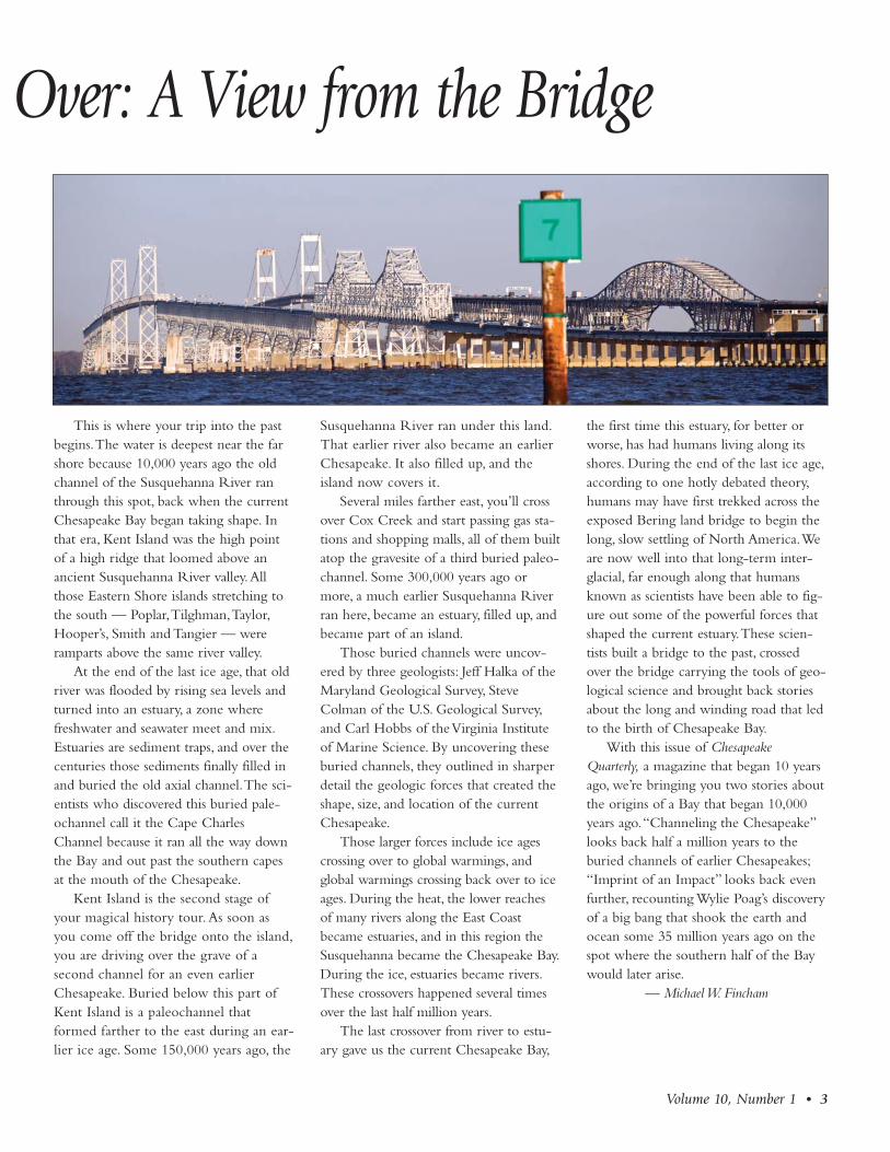
This is where your trip into the pastbegins. The water is deepest near the farshore because 10,000 years ago the oldchannel of the Susquehanna River ranthrough this spot, back when the currentChesapeake Bay began taking shape. Inthat era, Kent Island was the high pointof a high ridge that loomed above anancient Susquehanna River valley. Allthose Eastern Shore islands stretching tothe south — Poplar, Tilghman, Taylor,Hooper’s, Smith and Tangier — wereramparts above the same river valley.
At the end of the last ice age, that oldriver was flooded by rising sea levels andturned into an estuary, a zone wherefreshwater and seawater meet and mix.Estuaries are sediment traps, and over thecenturies those sediments finally filled inand buried the old axial channel. The sci-entists who discovered this buried pale-ochannel call it the Cape CharlesChannel because it ran all the way downthe Bay and out past the southern capesat the mouth of the Chesapeake.
Kent Island is the second stage ofyour magical history tour. As soon asyou come off the bridge onto the island,you are driving over the grave of asecond channel for an even earlierChesa peake. Buried below this part ofKent Island is a paleochannel thatformed farther to the east during an ear-lier ice age. Some 150,000 years ago, the
Susque hanna River ran under this land.That earlier river also became an earlierChesapeake. It also filled up, and theisland now covers it.
Several miles farther east, you’ll crossover Cox Creek and start passing gas sta-tions and shopping malls, all of them builtatop the gravesite of a third buried paleo -channel. Some 300,000 years ago ormore, a much earlier Susquehanna Riverran here, became an estuary, filled up, andbecame part of an island.
Those buried channels were uncov-ered by three geologists: Jeff Halka of theMaryland Geological Survey, SteveColman of the U.S. Geological Survey,and Carl Hobbs of the Virginia Instituteof Marine Science. By uncovering theseburied channels, they outlined in sharperdetail the geologic forces that created theshape, size, and location of the currentChesapeake.
Those larger forces include ice agescrossing over to global warmings, andglobal warmings crossing back over to iceages. During the heat, the lower reachesof many rivers along the East Coastbecame estuaries, and in this region theSusquehanna became the Chesapeake Bay.During the ice, estuaries became rivers.These crossovers happened several timesover the last half million years.
The last crossover from river to estu-ary gave us the current Chesapeake Bay,
the first time this estuary, for better orworse, has had humans living along itsshores. During the end of the last ice age,according to one hotly debated theory,humans may have first trekked across theexposed Bering land bridge to begin thelong, slow settling of North America. Weare now well into that long-term inter-glacial, far enough along that humansknown as scientists have been able to fig-ure out some of the powerful forces thatshaped the current estuary. These scien-tists built a bridge to the past, crossedover the bridge carrying the tools of geo-logical science and brought back storiesabout the long and winding road that ledto the birth of Chesapeake Bay.
With this issue of ChesapeakeQuarterly, a magazine that began 10 yearsago, we’re bringing you two stories aboutthe origins of a Bay that began 10,000years ago. “Channeling the Chesapeake”looks back half a million years to theburied channels of earlier Chesapeakes;“Imprint of an Impact” looks back evenfurther, recounting Wylie Poag’s discoveryof a big bang that shook the earth andocean some 35 million years ago on thespot where the southern half of the Baywould later arise.
— Michael W. Fincham
Over: A View from the Bridge

Jeff Halka of the Maryland Geological Survey helpedlead a search for ancient channels that could beburied under the bottom of the Bay. The firstevidence for paleochannels came from boreholesdrilled for the building of the Chesapeake BayBridge. What Halka and his collaborators foundchanged our understanding of how the ChesapeakeBay was created. PHOTOGRAPH BY MICHAEL W. FINCHAM.

He was reading The Hunt for RedOctober at work that Septem -ber, and his job was leaving
him time to devour long novels aboutRussian submarines. He was spending hiswork days on a 51-foot research boat thatwas creeping back and forth across theChesapeake Bay at four knots. In a hotcabin, sealed tight to keep out the flies, hemonitored two printers that were plottingout acoustic profiles for everything passingunder the boat. Towed behind the stern,two sleds of noisemakers were shootingclicks and clacks down at the bottom.
The sound waves could detect anyschools of fish passing by or ping on anyRussian submarines that managed tosneak past all the Navy ships down inNorfolk and slide up the deep mainstemchannel of the Bay. Jeff Halka, however,was a geologist, and he wasn’t hunting fishor submarines.
The year was 1985, Halka was 35years old, the Cold War was 40 years old,and the Chesapeake Bay, up here inMaryland waters, was about 6,000 yearsold. Trim, brown-haired, and bearded,Halka was using sound waves to searchdeep below the bottom of the Bay forsomething much older: the ancient chan-nels buried there long before humanbeings formed nations and went to war.He was looking for the ghosts of other,earlier Chesapeake Bays.
The current Chesapeake, according togeologists, is the drowned valley of theSusquehanna, the great river at the headof the Bay that pours in nearly 50 percent
of the river water entering the estuary.During the depths of the last ice age, theSusquehanna flowed south, then eastacross the dry, exposed plateau of the con-tinental shelf before emptying into a dis-tant Atlantic Ocean. When the glaciersbegan shrinking some 18,000 years ago,sea level began rising, sweeping backacross the plains of the continental shelf.About 10,000 years ago, the oceanreached the area we now call Norfolk,and seawater began flooding up the valleyof the Susquehanna, turning the lowerreaches of the river into an estuary.
An estuary like the Chesapeake is nei-ther ocean nor river — but somethingelse: an ecosystem that mixes fresh- andsaltwater, creating wetlands and water bot-toms, food webs and biological communi-ties found nowhere else. By 3,000 yearsago, the Chesapeake estuary had stretched190 miles north of Norfolk, pushing themouth of the Susquehanna River all theway up to Havre de Grace, Maryland.
This image of a “drowned river val-ley” has been widely accepted for 80 yearsas the creation story for Chesapeake Bay,but like evolution theory and big bangtheory and other big-picture origin sto-ries, it leaves some important questionsunanswered. If, for example, the end of
the last ice age created the current estuary,then what happened when other ice agesflourished and faded? As earlier glaciersmelted, sea levels must have risen thenalso, flooding earlier river valleys. If so,where were those earlier river channels?
For 30 years, bits and pieces of oldchannels had been turning up, mostlyunder bridge pilings. Some of the first bitscame with the building of the Chesa -peake Bay Bridge, the long-delayed struc-ture that would finally link the mainlandof Maryland more easily with its EasternShore counties along the DelmarvaPeninsula. When engineers in search offirm footing drilled boreholes across theBay in 1948, they hit coarse river gravel120 feet down, uncovering the first evi-dence that an ancient river valley wasburied beneath the Bay. Chunks of otherchannels came from other bridge sites,from well-drilling logs, and from severalshort research cruises.
But no one ever tried to connect allthese scattered dots until Halka teamed upwith Steve Colman of the U.S. GeologicalSurvey and Carl Hobbs of the VirginiaInstitute of Marine Science. Theylaunched a series of boat surveys designedto cover the entire mainstem of the estu-ary, with Halka running two cruises inMaryland waters, and Hobbs running twoin Virginia waters. Each two-week cruisecovered 25 percent of the Bay. Fourcruises covered the entire Bay — all inhopes of uncovering any ghost channelsand tracing out their ancient pathwaysthrough earlier estuaries .
Volume 10, Number 1 • 5
In Search of Ancient EstuariesMichael W. Fincham
CHANNELING THE CHESAPEAKE
“How did the Chesapeake Bay get here? How
did it come to be?”

Their survey would be the firstBaywide search for these old channels —and probably the last. In this current eraof funding cutbacks and practical researchgoals, their quest now seems almostquixotic. Men and boats and gear, allcommitted to finding channels that disap-peared tens of thousands, even hundredsof thousands of years ago. Geologists on asmall boat in the middle of a bay probingdown through dark waters — think ofastronomers in an observatory on top of amountain peering up into the night sky,looking back in time toward the edge ofthe universe.
How did this universe begin? Howdid this estuary begin? Questions aboutorigins are always compelling — indeedhumans seem programmed to keep askingorigin questions and writing origin narra-tives. Geologists, when they are not look-ing for oil and gas or minerals, seem evenmore programmed than other scientists totackle these issues. “How did the Chesa -peake Bay get here?” says Halka. “Thatwas my interest: how did it come to be?”By the time Halka, Colman, and Hobbsfinished their Baywide expeditions, theywould be ready to write a new, unex-pected origin story about the creation oftoday’s Chesapeake Bay.
Is there, however, any practical value tothis kind of old-fashioned basic research?Does (really) ancient history have any-thing to tell us about current struggles tosave Chesapeake Bay? Does the past haveanything to tell us about the future?
On September 28, 1985, Jeff Halkabegan his part of the search by motoringout of Solomons Island on a research boatso loaded up with high-voltage electricalgear that anybody on board could feel atleast a little nervous. The 51-foot RVDiscovery carried in its cockpit a massivegenerator for firing off voltage charges,two sets of towable noisemakers, a rack ofamplifiers and receivers, and two printerswith exhaust fans. With all the electronicssitting on board or dragging through thewater, everyone would be keeping an eyeon the weather.
September in Maryland is still hurri-
cane season, and Halka and his crew werelaunching just one day after HurricaneGloria had swept up the coastline, dump-ing heavy rains and tearing up boardwalksin Ocean City. September is also the tailend of thunderstorm season, and their realworry was the dark thunderheads thatoften come towering out of the west,crackling with lightning that’s looking fora strike point.
Riding with Halka was Steve Colman,also brown-haired and brown-bearded, butwith an early receding hairline. A keyplayer in setting up the search, Colmanworked for the U.S. Geological Survey,and he brought funding, equipment, and
staff support from the Survey’s WoodsHole office. After Halka and Hobbsarranged boats for the Maryland andVirginia surveys, the three geologistsworked out an extensive search plan. Theywould scour the entire Bay bottom withsound waves that penetrate the Bay floorand use the echoes to profile the sedimentlevels that lay beneath. The boats wouldrun long transects, back and forth, crawl-ing east and west, then north and south, ineffect, creating a grid, crosshatching theBay (see map on p. 7) with seismic probes.
For seismic profiling they were carry-ing two towable noisemakers aboard theRV Discovery. From the Maryland
What Is an Estuary?An estuary is neither ocean nor river, but a blending of both. According to one classic definition,
it’s a semi-enclosed body of water, open to the sea, where salty water from the ocean mixeswith freshwater from the land.
That definition dates from 1952 and came from Don Pritchard, the first professional oceanog-rapher to study the physics of Chesapeake Bay. It’s a definition that has weathered the passingdecades and the alternate definitions proposed by later scientists, largely because it captures theessential element, the mixing of fresh and salt, from which so many other estuarine features flow.
The definition of an estuary has changed little, but the classification of the world’s estuaries hasgrown more complicated over time. The Chesapeake Bay is called an estuary, but so is PamlicoSound, the Indian River Lagoon, the Mississippi Delta, San FranciscoBay, and Puget Sound. They all share one trait in common, but theyare often classified into different types based on features like theircirculation, their mixing patterns — and especially their geology.
Based on its geology, the Chesapeake Bay is classified as a coastalplain estuary or a drowned river estuary because it began life whenrising sea levels flooded into its major tributary following the end ofthe last ice age. Estuaries like Pamlico Sound in North Carolina, onthe other hand, began as bar-built, semi-enclosed bodies of watercreated by ocean currents piling up sand bars or barrier islands.Delta estuaries like the Mississippi Delta were also built by sand andsediment, but the sand was carried there by a river not the ocean.San Francisco Bay is a tectonic estuary, created when a suddenmovement of the earth’s crust formed a basin that ocean and riverwater quickly filled in. Glacier Bay in Alaska and parts of PugetSound are fjords, deep channels carved into the earth by glaciers.
Estuaries are common along the Atlantic and Gulf coasts, wherethey cover 80-90% of the coastline. They are uncommon along thePacific coast, where they account for only 10-20% of the coastalwaters.
Of all this country’s estuaries, the Chesapeake Bay is thelargest, and has been historically the richest in biological productiv-ity. Its great rivers, streams, creeks, and coves intertwine withislands and peninsulas and necks to create a variety of habitats forwildlife, waterfowl, wetlands, and fish. The bottom of the Bay ishome to seagrass beds, oyster reefs, and many bottom-dwellingshellfish like blue crabs, clams, and mussels. An estimated 350 fishspecies live part of their lives in the Bay. Despite declining waterquality and shrinking habitats, the Chesapeake is still a rich estuary— in part because of restoration efforts launched in recentdecades, in part because of the resilience of the animals and plantsthat adapted to the variable conditions in an ecosystem that mixesriver and ocean.
6 • Chesapeake Quarterly
Estuary
DeltaRiver
Coastal Plain Estuary
SOURCE: OFFICE OF NAVAL RESEARCH.
Estuary
Faults
Tectonic Estuary
Estuary
Sand Spit
Bar-Built Estuary
Fjord
SteepWalls
Fjord

Geological Survey, Halka brought a trans-ducer that could fire off four clicks aminute. From the U.S. Geological Survey,Colman brought a boomer that couldbang off louder claps at the same rate.Widely used in seismic searches for under-water oil and gas, the boomer works bybashing two metal plates together to createa rapid series of claps or pressure waves.
Once on station, the RV Discoveryslowed to four knots, the captain startedrunning a transect, and the work day fellinto a familiar rhythm. He watched forcrab pots, the noisemakers clicked andclapped, the plotters traced out profiles ofthe bottom. In the cabin Halka and
Colman could hear the echoes comingback toward the hull: a small sound comesoff soft mud, something louder from hardbottom. In tee shirts and shorts they werespending most of their time on the end-less bookkeeping of data taking: trackingthe course, making notes on data sheetsand nautical charts, changing reels in thetape recorders, changing paper in theplotter, changing the stylus in the plotter.
The two-week cruise fell into itsrhythm. The boat would creep across theBay, the plotter would inch across thepaper. Running long, slow transects in acrosshatch grid was always boring work.Boat crews called it “mowing the lawn,”
and drank lots of coffee to stay awake.Dusk would bring a dock, a nice marina,a nearby bar (a bar could be a necessity).Then a motel bed and more readingbefore sleep. Waking before dawn inSolomons Island or Tilghman Island, inCambridge or Crisfield, everyone had tograb a quick breakfast, then head outagain in the early light.
Crabs pots and thunderstorms wereproblems. Pots would catch on the sledsor the hydrophones where they wouldhang up and drag and mess up the dataflow. Thunderstorms meant a run for har-bor and a short day. A lightning strike
Volume 10, Number 1 • 7
Continued on p. 10
Delm
arva Peninsula
Chesapeake
Bay
A basic array for creating an acoustic profile includes a boat, a towable noisemaker thatshoots sound waves, towable hydro phones that catch the echoes, and then on-board recordinggear that translates the echoes into data. Seismic profilers use low-frequency sound waves thatreflect off the bottom but then keep penetrating deeper, sending echoes back from each densitylayer they encounter. The lower the frequency, the deeper the echo. Steve Colman of the U.S.Geological Survey monitors on-board data-recording gear. On his left: two printers sitting atopexhaust fans; then power supplies, including amps and receiver; and stacked above, more elec-tronic gear, including LORAN and an oscilloscope to monitor the acoustic signals. The map(left) shows the survey grid the boat followed: a back-and-forth, up-and-down crosshatching ofthe mainstem of the Chesapeake. PHOTO GRAPH COURTESY OF THE U.S. GEOLOGICAL SURVEY; MAP ADAPTED
FROM FIGURE 1 IN COLMAN ET AL. (1990); BOAT SCHEMATIC ADAPTED FROM A FIGURE BY JEFF HALKA.

In 1938, a line of test boreholes wasdrilled across Chesapeake Baybetween Sandy Point and Kent Island
in hopes that a bridge (or possibly a tun-nel) might finally be erected that couldlink the Maryland mainland and itsEastern Shore counties with somethingfaster than steamboats and ferries.
A funny thing happened on the wayto the Eastern Shore: geologists discoveredevidence of an older Chesapeake buriedbeneath the Bay.
It would be a discovery slow in com-ing. Hopes for a Chesapeake Bay bridgeor tunnel had been rising and falling formore than 30 years: committees and com-missions had formed, tunnels and trolleycar bridges had been proposed, otherlocations had been studied. No bridgewas needed, according to The BaltimoreSun, because everybody would soon beflying their own planes. No bridge was
wanted, according toEastern Shore natives,because their way of lifemight be contaminated bytoo frequent contact withfellow citizens from thefar shore.
No bridge was built.The samples and logs fromthe 1938 test borings wentinto dry storage foranother decade.
In 1948, hope flaredagain when Governor William PrestonLane pushed through a funding plan, andthe Raymond Concrete Pile Companythen drilled 23 new test borings across theBay. While none of the cores struckbedrock, they reached as deep as 257 feetbelow the water and found enough firmsand to support bridge pilings. The nextyear the J.E. Greiner Company began
erecting the Chesapeake Bay Bridge, thelargest public construction project inMaryland history, a four-mile steel struc-ture with two twin towers that wouldreach as high as 354 feet above the water.On July 30, 1952, the bridge opened withspeeches and sightseeing tours and a lineof cars headed east. Life on the EasternShore, for better or worse, would never bethe same.
8 • Chesapeake Quarterly
BRIDGE OVER BURIED RIVERS
Standing on the newlybuilt Chesapeake Bay Bridgein 1952 is former GovernorWilliam Preston Lane (p. 9), who had pushedthrough funding for the bridge. Construction began in 1949, but a lotof preparation came first. To find the best locations for the bridge’s foundation, engineers drilleda series of boreholes. The coring logs, which included detailed descriptions of the color and texture of sediments at different levels, providedgeologists with information valuable in mapping out the channels of ancient estuaries. This illustration shows an approximation of how the bore-holes from 1938 and 1948 and the underground cross section of soil layers they revealed line up with the above-the-water bridge. The layer withsmall dots indicates sand and gravel — for geologists the sign of a riverbed. This deposit clearly outlines the sides and bottoms of buried riverchannels. The deepest channel runs well to the east of the center span of the bridge. Geologists believe it is the paleochannel of the Sus que hannaRiver Valley as it was some 18,000 years ago. Named the Cape Charles Channel (see map on p. 11), it runs all the way to the mouth ofChesapeake Bay. To the west of the deep channel is a shallower paleochannel beneath the center span of the bridge. This channel could be a tribu-tary, perhaps the Patapsco River, which may have flowed through here on its way to hook up with the Susquehanna. ILLUSTRATIONS ADAPTED FROM
DRAWINGS IN THE CHESAPEAKE BAY BRIDGE ENGINEERING REPORT (J.E. GRAINER 1948).
Michael W. Fincham
Balti
mor
e Su
n M
edia
Gro
up. A
ll rig
hts
rese
rved
.
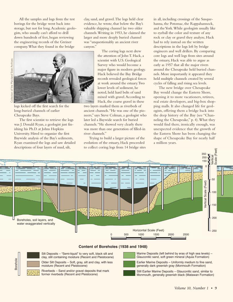
All the samples and logs from the testborings for the bridge went back intostorage, but not for long. Academic geolo-gists, who usually can’t afford to drilldown hundreds of feet, began reviewingthe engineering records of the Greinercompany. What they found in the bridge
logs kicked off the first search for thelong-buried channels of earlierChesapeake Bays.
The first scientist to retrieve the logswas J. Donald Ryan, a geologist just fin-ishing his Ph.D. at Johns HopkinsUniversity. Hired to organize the firstBaywide analysis of the Bay’s sediments,Ryan examined the logs and saw detaileddescriptions of four layers of mud, silt,
clay, sand, and gravel. The logs held clearevidence, he wrote, that below the Bay’svaluable shipping channel lay two olderchannels. Writing in 1953, he claimed thelarger and more deeply buried channelwas “unquestionably an ancient rivercanyon.”
The coring logs next drewthe attention of John T. Hack, ascientist with U.S. GeologicalSurvey who would become amajor figure in modern geology.Hack believed the Bay Bridgerecords revealed geological forcesat work around the estuary. Twolower levels of sediment, henoted, held hard belts of sandmixed with gravel. According toHack, the coarse gravel in these
two layers marked them as riverbeds ofancient channels. “He was one of the pio-neers,” says Steve Colman, a geologist wholater led a Baywide search for buriedchannels. “He showed very clearly therewas more than one generation of filled-inriver channels.”
Trying to build a larger picture of theevolution of the estuary, Hack proceededto collect coring logs from 14 bridge sites
in all, including crossings of the Susque -hanna, the Potomac, the Rappa hannock,and the York. While geologists usually liketo eyeball the color and texture of anyrock or clay or gravel they analyze, Hackhad to rely instead on the writtendescriptions in the logs left by bridgeengineers and well drillers. By comparingcore logs and well logs from sites aroundthe estuary, Hack was able to argue asearly as 1957 that all the major riversaround the Chesapeake held buried chan-nels. More importantly it appeared theyheld multiple channels created by severalcycles of falling and rising sea levels.
The new bridge over ChesapeakeBay would change the Eastern Shore,opening it to more vacationers, retirees,real estate developers, and big-box shop-ping malls. It also changed life for geol-ogists, offering them a bridge back intothe deep history of the Bay (see “Chan -neling the Chesapeake,” p. 4). What theywould find there, ironically enough, wasunexpected evidence that the growth ofthe Eastern Shore has been changing theshape of Chesapeake Bay for nearly halfa million years.
Volume 10, Number 1 • 9
– 50
– 100
– 150
– 200
– 250
Ver
tical
Sca
le (
Fee
t)
350 –250–150–
Ver
tical
S
cale
(F
eet)
Silt Deposits – “Semi-liquid” to very soft, black silt andclay, still containing moisture (Recent and Pleistocene)
Older Silt Deposits – Soft, gray, silt and clay, with lessmoisture (Recent and Pleistocene)
Riverbeds – Sand and/or gravel deposits that mark former riverbeds (Recent and Pleistocene)
Marine Deposits (left behind by eras of high sea levels) –Glauconitic sand, soft green mineral (Aquia Formation)
Earlier Marine Deposits – Uniformly medium to fine sand, generally dark greenish gray (Monmouth Formation)
Still Earlier Marine Deposits – Glauconitic sand, similar toMonmouth, generally greenish black (Matawan Formation)
Horizontal Scale (Feet)0 500 1000 1500 2000 2500
0
Content of Boreholes (1938 and 1948)
Boreholes, soil layers, andwater exaggerated vertically
Col
lect
ion
of t
he M
aryl
and
Stat
e A
rchi
ves
Bor
ehol
e

could fry a lot of electronics, scare a cou-ple of scientists, and end the whole cruise.
The plotter was the big problem. Itwas the end point in the data chain, theraison d’être for all the boat work, and itwould go funky. To create the data record,it used three-layer paper with a carbonmidsection. A stylus burned through thetop layer, exposing the carbon layer andspewing burnt carbon dust into the cabin.As long as the exhaust fans were workingand the windows were open, life wasbearable. When the flies came out, mostlyalong the Eastern Shore, and the windowswere shut, and the fans broke down, thenlife would stink. Dust filled the cabinsmelling like ozone and burning hair.Everyone hustled to fix the fans, some gotseasick, no one ever forgot the stench.
Amidst the drudgery: sudden discover-ies. Leaning over the plotter, Halka andColman could see an ancient channel takeshape before their eyes. On the plot, aslice of buried channel looked like theskeleton of a sunken ship filled with sedi-ment. First a down slant, then a levelingout, then a curving back up. A bow, thena keel, then a stern. What looked like aship was actually the outline of a riverbank, a channel bottom, a far shore. Aghost image from a long-ago Chesapeake.
Each glimpse into the past was quicklygone. The boat plodded on, tracking alongits appointed transect. Nobody broke thegrid to give chase and track down the restof the channel. On the next pass backacross the Bay they cut across a secondslice of the channel. The third pass cutanother slice. The fourth pass, anotherslice. The grid was all. The slices wouldadd up, the channel track would takeshape.
In their data several tracks ofburied rivers would take shape. Piecingthe slices together, Halka, Colman, andHobbs would discover three paleochan-nels of the ancestral Susquehanna hiddenbeneath the Bay.
In his office at the Maryland Geo -logical Survey, Jeff Halka unrolls strips of
plotter paper and spreads them out on along table so he can show me the seismicprofiles from 1985. Halka is older now,but still trim and fit-looking with reced-ing hair and graying beard. Leaning overhis data sheets, he explains the new find-ings — and the new questions — thatemerged from all those long days onslow-moving boats.
Three Susquehanna Rivers ran to thesea during three earlier ice ages, he says,and with rising sea levels each became adrowned river estuary much like the cur-rent Chesapeake. One paleochannel isabout 18,000 years old, a second, older
paleochannel dates to 150,000 years ago,and the oldest — and most difficult todate — is 300,000 to 500,000 years old.
Other discoveries followed, raisingtricky questions. As each new Susque -hanna River formed, it created a newcourse. Instead of stacking itself on top ofan older channel, the new river wouldshift course. Why the shift? “If we havethese different channels that are all in dif-ferent locations,” answers Halka. “Thatimplies the Chesapeake had to fill in withsediments.”
But the new river locations were, forthe most part, always to the west. And the
10 • Chesapeake Quarterly
Channeling, from p. 7 300,000-500,000 years ago
ExmoreChannel
Bay Bridge Islands
P PoplarK KentT Tilghman
TA TaylorH Hooper’sS Smith
TN Tangier
TN
K
TA
P
T
H
S
Exmore
Chesapeake
Bay
Three ancient channels lie buriedbeneath the modern-day ChesapeakeBay, each one named for the townnear where it once exited to the ocean.
Exmore Channel. This is the oldestburied paleochannel of the Susque -hanna River. Running under KentIsland, Poplar Island, and Hooper’sIsland, it tracks to the east of Smithand Tangier islands. It then crossesunder the Delmarva Peninsula. Whenthe channel was an active river, it wasfed by the Patuxent and the Potomacrivers. It formed the southern end ofthe Delmarva.
Eastville Channel. This channelhas a track that is shifted to the westfor most of its run, though it swingswest and east more wildly than theother channels. It also runs under partof Kent Island, and it crosses theDelmarva farther south. As an activeriver it was fed by the RappahannockRiver, and for a time it formed the tipof the Delmarva.
Cape Charles Channel. This chan-nel is shifted still farther west again. Itwas the axial channel of the Susque -hanna River when rising sea levelsbegan turning the river into our cur-rent Chesapeake Bay. Its track runsnear the modern deep channel. As ariver, it captured all the western shorerivers except the James. Once 160 feetdeep at the mouth of the Chesapeake,the channel was quickly buried underFisherman’s Island by sand and sedi-ment from the sea. MAPS AND CHANNELS
REDRAWN FROM FIGURE 8 IN COLMAN ET AL.
(1990).
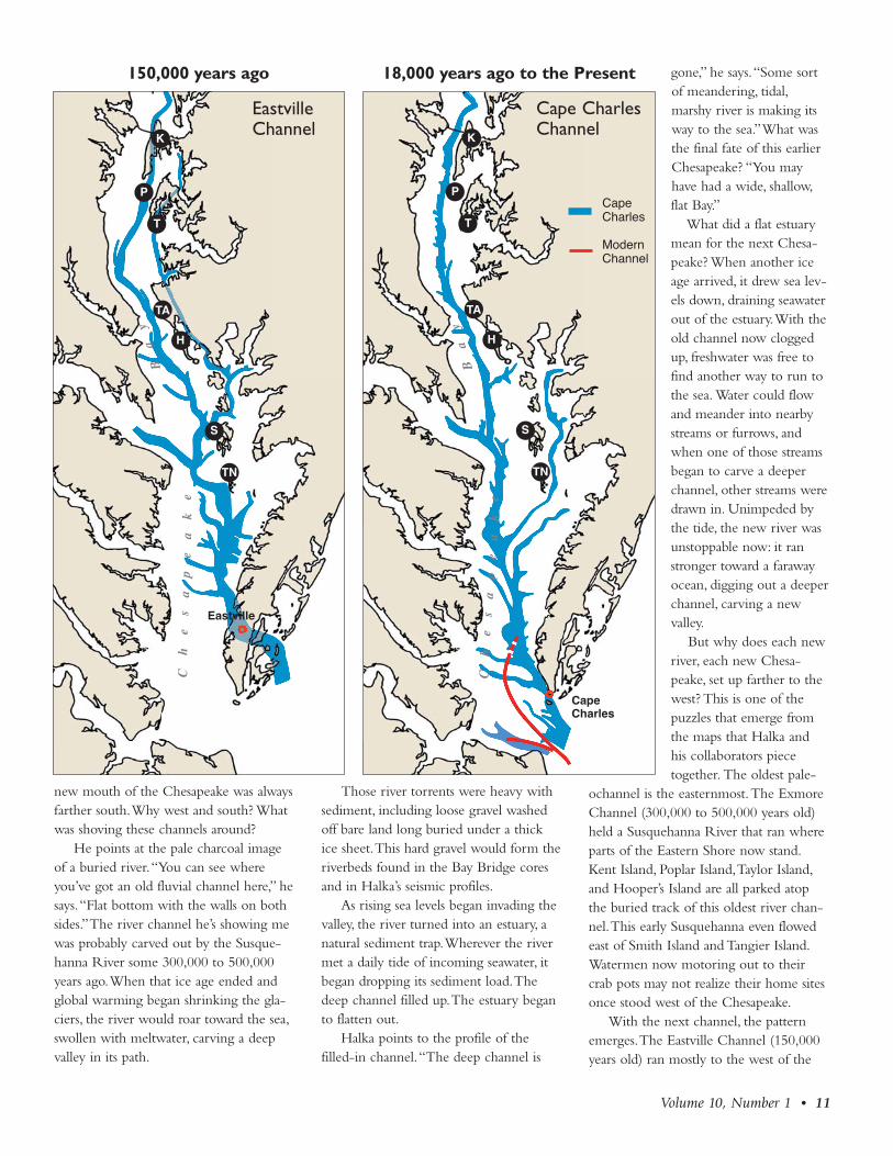
new mouth of the Chesapeake was alwaysfarther south. Why west and south? Whatwas shoving these channels around?
He points at the pale charcoal imageof a buried river. “You can see whereyou’ve got an old fluvial channel here,” hesays. “Flat bottom with the walls on bothsides.” The river channel he’s showing mewas probably carved out by the Susque -hanna River some 300,000 to 500,000years ago. When that ice age ended andglobal warming began shrinking the gla-ciers, the river would roar toward the sea,swollen with meltwater, carving a deepvalley in its path.
Those river torrents were heavy withsediment, including loose gravel washedoff bare land long buried under a thickice sheet. This hard gravel would form theriverbeds found in the Bay Bridge coresand in Halka’s seismic profiles.
As rising sea levels began invading thevalley, the river turned into an estuary, anatural sediment trap. Wherever the rivermet a daily tide of incoming seawater, itbegan dropping its sediment load. Thedeep channel filled up. The estuary beganto flatten out.
Halka points to the profile of thefilled-in channel. “The deep channel is
gone,” he says. “Some sortof meandering, tidal,marshy river is making itsway to the sea.” What wasthe final fate of this earlierChesapeake? “You mayhave had a wide, shallow,flat Bay.”
What did a flat estuarymean for the next Chesa -peake? When another iceage arrived, it drew sea lev-els down, draining seawaterout of the estuary. With theold channel now cloggedup, freshwater was free tofind another way to run tothe sea. Water could flowand meander into nearbystreams or furrows, andwhen one of those streamsbegan to carve a deeperchannel, other streams weredrawn in. Unimpeded bythe tide, the new river wasunstoppable now: it ranstronger toward a farawayocean, digging out a deeperchannel, carving a newvalley .
But why does each newriver, each new Chesa -peake, set up farther to thewest? This is one of thepuzzles that emerge fromthe maps that Halka andhis collaborators piecetogether. The oldest pale-
ochannel is the easternmost.The ExmoreChannel (300,000 to 500,000 years old)held a Susquehanna River that ran whereparts of the Eastern Shore now stand.Kent Island, Poplar Island, Taylor Island,and Hooper’s Island are all parked atopthe buried track of this oldest river chan-nel. This early Susquehanna even flowedeast of Smith Island and Tangier Island.Watermen now motoring out to theircrab pots may not realize their home sitesonce stood west of the Chesapeake.
With the next channel, the patternemerges. The Eastville Channel (150,000years old) ran mostly to the west of the
Volume 10, Number 1 • 11
150,000 years ago 18,000 years ago to the Present
EastvilleChannel
Cape CharlesChannel
Modern Channel
Cape Charles
Eastville
Cape Charles
Chesapeake
Bay
Chesapeake
Bay
TN
K
TA
P
T
H
S
TN
K
TA
P
T
H
S

older Exmore Channel.And the youngest channel,the Cape Charles Channel(18,000 years old) stayedmostly to the west of bothearlier channels .
Another puzzleemerges. As each ancientriver shifted west, eachone pushed the mouth ofthe Chesapeake farthersouth. In Virginia watersthe surveys were run byColman and Carl Hobbsfrom VIMS, but the chan-nels they were trackingwent where no boat couldfollow. Motoring back andforth across the southernChesapeake, Hobbs andColman would eventuallylose track of the Exmoreand the Eastville channels.One by one they disap-peared under Virginia’sEastern Shore, leaving thegeologists to guess atwhere the old channelswent next and where theymet the ocean.
Guesses are big in science (they’re usuallycalled hypotheses) — butsometimes luck is bigger.
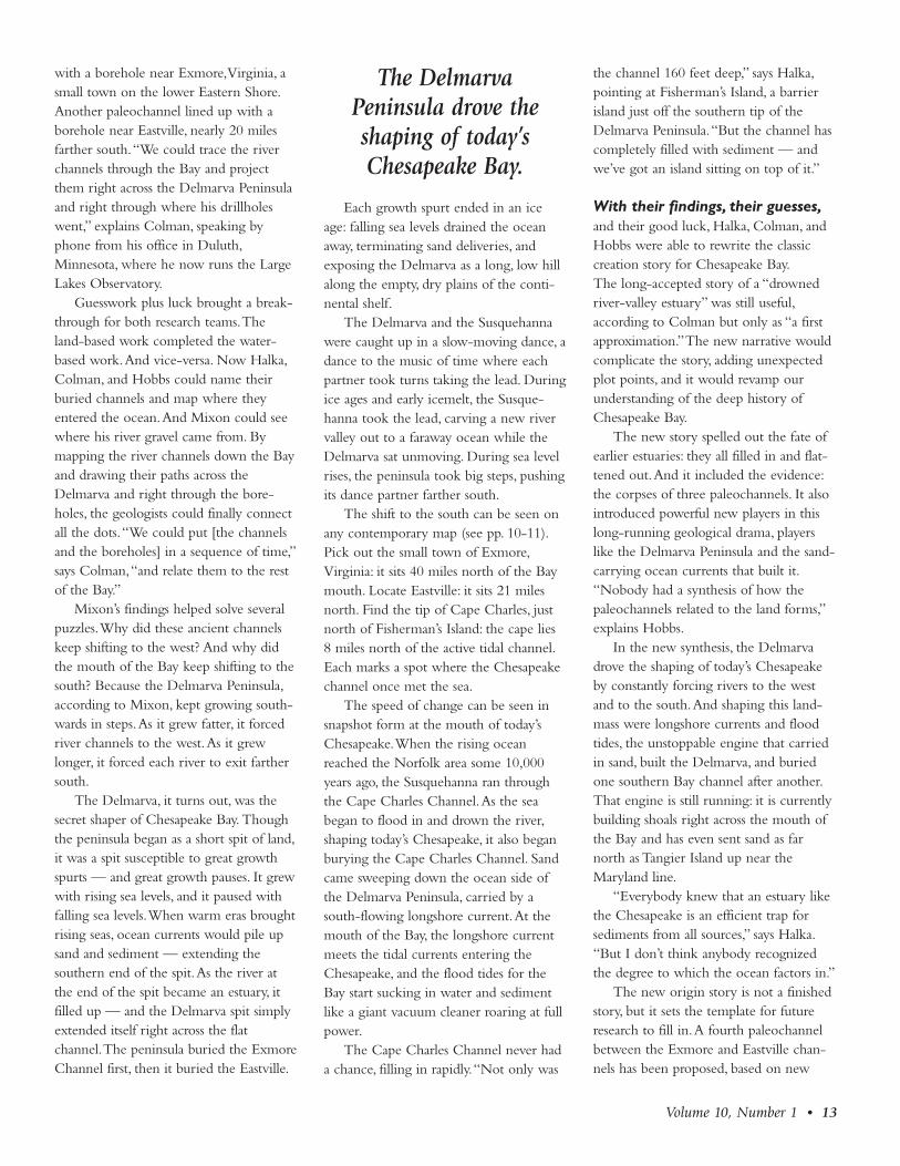
Before Halka and hiscollaborators began theirboat surveys, RobertMixon was already drillingdeep boreholes in thelower reaches of theDelmarva Peninsula. Aland-based researcher withthe U.S. Geological Survey,Mixon was trying to figureout the underlying geologyof the Delmarva Peninsula, that longskinny landmass that separates theChesapeake Bay from the AtlanticOcean. Stretching 183 miles in all, thepeninsula now holds all of Delaware andthe Eastern Shore sections of Marylandand Virginia.
It was Mixon who provided the luck.When cores from two of his boreholesshowed coarse river-bed gravel, Mixonspeculated that some long-ago rivers onceran there. He published his findings in1985, about the time Halka, Colman, andHobbs were beginning their boat surveysof the Chesapeake.
It was Steve Colman who providedthe guesswork. He looked at where hispaleochannels disappeared under thepeninsula, and he looked at where Mixonhad found river gravel. Then he madesome guesses and began drawing dottedlines from his channels to Mixon’s bore-holes. His oldest paleochannel lined up
12 • Chesapeake Quarterly
Accomac SpitDevelopment
UPLANDS
Nassawadox SpitDevelopment
UPLANDS
Nassawadox SpitExtension
UPLANDS
400,000 years ago
210,000 years ago
125,000 years ago
Carl “Woody” Hobbs organized the boat surveys that searched the lower Bay for buried paleochannels. From hisoffice at the Virginia Institute of Marine Science, he can look out his window past the mouth of the York River and seethe Eastern Shore of Virginia, which forms the lower part of the Delmarva Peninsula. During earlier versions ofChesapeake Bay, however, he would have had an ocean-front view. The Delmarva Peninsula took its time getting here— a lot of time, in fact. It stretched south in steps, according to research by Robert Mixon of the U.S. Geological Survey.It began as a spit of land, but grew longer during eras of rising sea levels when longshore ocean currents piled sand andsediment onto its southern tip. By forcing future channels farther west and south, the Delmarva became a force in theslow shaping of today’s Chesapeake Bay. PHOTOGRAPH BY MICHAEL W. FINCHAM.; MAPS ADAPTED FROM FIGURES IN HOBBS (2004).
Evolution of the Delmarva Peninsula
with a borehole near Exmore, Virginia, asmall town on the lower Eastern Shore.Another paleochannel lined up with aborehole near Eastville, nearly 20 milesfarther south. “We could trace the riverchannels through the Bay and projectthem right across the Delmarva Peninsulaand right through where his drillholeswent,” explains Colman, speaking byphone from his office in Duluth,Minnesota, where he now runs the LargeLakes Observatory.
Guesswork plus luck brought a break-through for both research teams. Theland-based work completed the water-based work. And vice-versa. Now Halka,Colman, and Hobbs could name theirburied channels and map where theyentered the ocean. And Mixon could seewhere his river gravel came from. Bymapping the river channels down the Bayand drawing their paths across theDelmarva and right through the bore-holes, the geologists could finally connectall the dots. “We could put [the channelsand the boreholes] in a sequence of time,”says Colman, “and relate them to the restof the Bay.”
Mixon’s findings helped solve severalpuzzles. Why did these ancient channelskeep shifting to the west? And why didthe mouth of the Bay keep shifting to thesouth? Because the Delmarva Peninsula,according to Mixon, kept growing south-wards in steps. As it grew fatter, it forcedriver channels to the west. As it grewlonger, it forced each river to exit farthersouth.
The Delmarva, it turns out, was thesecret shaper of Chesapeake Bay. Thoughthe peninsula began as a short spit of land,it was a spit susceptible to great growthspurts — and great growth pauses. It grewwith rising sea levels, and it paused withfalling sea levels. When warm eras broughtrising seas, ocean currents would pile upsand and sediment — extending thesouthern end of the spit. As the river atthe end of the spit became an estuary, itfilled up — and the Delmarva spit simplyextended itself right across the flatchannel . The peninsula buried the ExmoreChan nel first, then it buried the Eastville.
Each growth spurt ended in an iceage: falling sea levels drained the oceanaway, terminating sand deliveries, andexposing the Delmarva as a long, low hillalong the empty, dry plains of the conti-nental shelf.
The Delmarva and the Susquehannawere caught up in a slow-moving dance, adance to the music of time where eachpartner took turns taking the lead. Duringice ages and early icemelt, the Susque -hanna took the lead, carving a new rivervalley out to a faraway ocean while theDelmarva sat unmoving. During sea levelrises, the peninsula took big steps, pushingits dance partner farther south.
The shift to the south can be seen onany contemporary map (see pp. 10-11).Pick out the small town of Exmore,Virginia: it sits 40 miles north of the Baymouth. Locate Eastville: it sits 21 milesnorth. Find the tip of Cape Charles, justnorth of Fisherman’s Island: the cape lies8 miles north of the active tidal channel.Each marks a spot where the Chesapeakechannel once met the sea.
The speed of change can be seen insnapshot form at the mouth of today’sChesapeake. When the rising oceanreached the Norfolk area some 10,000years ago, the Susquehanna ran throughthe Cape Charles Channel. As the seabegan to flood in and drown the river,shaping today’s Chesapeake, it also beganburying the Cape Charles Channel. Sandcame sweeping down the ocean side ofthe Delmarva Peninsula, carried by asouth-flowing longshore current. At themouth of the Bay, the longshore currentmeets the tidal currents entering theChesa peake, and the flood tides for theBay start sucking in water and sedimentlike a giant vacuum cleaner roaring at fullpower.
The Cape Charles Channel never hada chance, filling in rapidly. “Not only was
the channel 160 feet deep,” says Halka,pointing at Fisherman’s Island, a barrierisland just off the southern tip of theDelmarva Peninsula. “But the channel hascompletely filled with sediment — andwe’ve got an island sitting on top of it.”
With their findings, their guesses,and their good luck, Halka, Colman, andHobbs were able to rewrite the classiccreation story for Chesapeake Bay. The long-accepted story of a “drownedriver-valley estuary” was still useful,according to Colman but only as “a firstapproximation.” The new narrative wouldcomplicate the story, adding unexpectedplot points, and it would revamp ourunderstanding of the deep history ofChesapeake Bay.
The new story spelled out the fate ofearlier estuaries: they all filled in and flat-tened out. And it included the evidence:the corpses of three paleochannels. It alsointroduced powerful new players in thislong-running geological drama, playerslike the Delmarva Peninsula and the sand-carrying ocean currents that built it.“Nobody had a synthesis of how thepaleochannels related to the land forms,”explains Hobbs.
In the new synthesis, the Delmarvadrove the shaping of today’s Chesapeakeby constantly forcing rivers to the westand to the south. And shaping this land-mass were longshore currents and floodtides, the unstoppable engine that carriedin sand, built the Delmarva, and buriedone southern Bay channel after another.That engine is still running: it is currentlybuilding shoals right across the mouth ofthe Bay and has even sent sand as farnorth as Tangier Island up near theMaryland line.
“Everybody knew that an estuary likethe Chesapeake is an efficient trap forsediments from all sources,” says Halka.“But I don’t think anybody recognizedthe degree to which the ocean factors in.”
The new origin story is not a finishedstory, but it sets the template for futureresearch to fill in. A fourth paleochannelbetween the Exmore and Eastville chan-nels has been proposed, based on new
Volume 10, Number 1 • 13
The Delmarva Peninsula drove the shaping of today’sChesapeake Bay.

boreholes. And other, earlier channels maylie completely buried under the EasternShore where boat sampling could neverlocate them. An ancient paleochannelserves as the groundwater supply forSalisbury, Maryland, but where it origi-nated remains a mystery. Tracing thatchannel back to Chesapeake Bay orDelaware Bay would be too expensive,requiring land-based boreholes and seis-mic sampling techniques that are usuallyreserved for locating gas and oil.
The ghost channels that JeffHalka helped find some 25 years ago havenow come back to haunt him.
The year is 2011, the Cold War isover, the Chesapeake Bay is older, and lastyear Jeff Halka became director of theMaryland Geological Survey. The job getshim the corner office with large windowsand a lot of wooden bookshelves, but itdoesn’t leave him much time anymore forexploring big-picture stories about theshaping of Chesapeake Bay.
The current work list for his agency isclogged with highly practical issues likegroundwater supplies around the state,shale gas deposits in Western Maryland,salt-water intrusion on the Eastern Shore,shoreline erosion, and buried oyster beds.One never-ending problem is familiar:sediments keep filling today’s shippingchannels the way they once filled thoselong-ago ghost channels.
What ships, after all, will sail to Balti -more through a filled-up channel and aflattened estuary? Ships already have topass through 11 man-made channels tosail up the Bay. Near the mouth the chan-nels are filling with sand from the ocean.Near Baltimore they are filling with sedi-ment from the land. When these depositsare dredged out of those channels, Halkahelps figure out where to put them. Aspart of his job, he works with the Port ofBaltimore on their 20-year dredge spoilmanagement plan.
It’s clear from the ghost channels,however, that the port of Baltimore willalso need a 200-year management plan,even a 2,000-year management plan. The
message from his ghost channels is unam-biguous and highly practical. The problemof the ship channels will never go away.When it comes to dredging, says Halka,“We are never going to be able to stop.”
It seems the ghost channels have a lotto say about today’s estuary. Sedimentrunoff, unfortunately, does more than fillin shipping channels. It also darkens theBay, cuts off sunlight, kills off seagrasses,and buries oyster beds. As a result, con-trolling sediments has become a high pri-ority in the current campaign to restoreor at least preserve Chesapeake Bay.Farmers are trying contour plowing, no-till agriculture, winter cover crops, andbuffer zones. Home builders and highwayengineers are using hay bales and sedi-ment ponds. Cities and towns are lookingfor new ways to control stormwaterrunoff. Environmentalists are plantingtrees and living shorelines and seagrasses.
The list goes on. And the work goeson. And if the work ever stops, the riverchannel will fill up, the estuary will flattenout, and the Bay mouth will narrowdown. We won’t need a high-archingbridge to reach the Eastern Shore, just acauseway for driving or a pair of wadersfor walking.
14 • Chesapeake Quarterly
An Imprint
It came from outer space. A massivemeteoroid, at least 2 miles wide, hur-tled toward Earth at 60,000 miles per
hour. Upon impact it extinguished lifewithin several hundred miles. Its force:100 times greater than the entire nucleararsenal of the world. Tsunami wavescrashed on land. Clouds of pulverizeddebris blocked the sun. Then, acid rainpoured. Be thankful you didn’t call theChesapeake home 35 million years ago.
For hundreds of years people sailedthe Bay, studied the Bay, without knowingthe story hiding beneath it. There wereclues along the way. Oddities that befud-dled researchers. Things that just didn’tmake sense. It took a scientist from WoodsHole on Cape Cod to piece together themystery and discover the proof: a 50-mile-wide crater buried one mile beneaththe Chesa peake and southeastern Virginia.An imprint of an impact that, he says, stillaffects us today.
C. Wylie Poag calls himself a lithobio-seismostratigrapher. It even says so on hisbusiness card. After reviewing some Latinand Greek roots, you’ll find Poag figuresout the geologic history of an area. ButPoag, now an emeritus scientist for theUnited States Geological Survey (USGS),could add a simpler title to his card —sleuth.
In 1983, he was serving as co-chiefscientist onboard a drill ship off the coastof New Jersey when the team made anintriguing discovery. One of their samplescontained tektites (beads of silica glass),which are considered “unequivocal diag-nostic evidence” that a meteoroid hadonce struck the East Coast of the UnitedStates. But where?
Three years later, the USGS andVirginia State Water Control Board drilledseveral cores to help them evaluate poten-tial sources of fresh groundwater in south-eastern Virginia. Cores give researchers alook at the layers of rock under the sur-
Jessica Smits
For More InformationColman, S.M., J.P. Halka, C.H. Hobbs, R.B.Mixon, and D. S. Foster. 1990. Ancientchannels of the Susquehanna Riverbeneath Ches a peake Bay and the Del-marva Peninsula. Geological Society ofAmerica Bulletin (September) 102:1268-1279.
Hobbs, C.H. 2004. Geological history ofChesapeake Bay, USA. Quaternary Sci-ence Reviews 23(5-6):641-661.
Hack, J.T. 1957. Submerged river systemof Chesapeake Bay: Geological Society ofAmerica Bulletin 68:817-830.
Ryan, D.J. 1953. The Sediments of Chesa-peake Bay. Maryland Department ofGeology, Mines and Water ResourcesBulletin12. 120 p.
Poag, C.W. 1999. Chesapeake Invader:Discovering America’s Giant MeteoriteCrater. Princeton University Press. 183 p.

face — their content, age, and attributes.Each layer serves as a sort of time capsule,offering a glimpse of the Earth at thattime. But the recovered cores did not fol-low this layer cake recipe.
Wylie Poag was one ofthe scientists charged withanalyzing the cores’ puz-zling contents. He writesthat instead of neat layerswith the youngest on topand the oldest on bottom,the sediments were “wildlydisarranged.” It was appar-ent to him that somethingpowerful had mixed layersof geologic history intoone single layer anddumped it over an area thesize of Connecticut. Wassoutheastern Virginia thelocation of the East Coastmeteoroid strike?
To answer that question,Poag turned to Texaco andExxon in 1993. In theirsearch for oil beneath theChesapeake, the companieshad collected seismicreflection profiles: two-dimensional line drawingsof the Bay bottom. OncePoag laid eyes on the pro-files he knew he had foundwhat he was looking for.The drawings showed ahuge hole beneath the Bay— a crater that spannedmore than 50 miles andwas almost as deep as theGrand Canyon. “Groundzero” was the spot wherethe town of Cape Charlesnow stands.
The oil companies hadthe data, but it neveroccurred to anyone that it
was a massive impact crater, Poag says.“They were puzzled, but they weren’tthinking that way.” Because of what he’dseen in New Jersey and Virginia, Poag says,“I’d been thinking that way.”
“Thinking that way” gave Poag thehighlight of his career. News of the craterdiscovery attracted media attention fromaround the globe. “It was a heady time,”he recalls.
But what does the presence of a 35-million-year-old crater mean today?
For one, it answered the questionabout some very salty water in southeast-ern Virginia, Poag says. The impact blastdestroyed ground-water aquifers in a 200-square-mile area, creating a single reservoirfilled with water 1.5 times saltier than sea-water. This brine reservoir makes findingfreshwater aquifers difficult. Hydrologistshad known about the brine water butdidn’t understand its origin. Knowing thelocation of the crater now makes it possi-ble to plot the distribution of the waterand know where to find fresh water andwhere not to find it, Poag says.
Additionally, the watery sediment(breccia) that fills and surrounds the craterhas implications for cities nearby. Heaviersediment piled on top can force compac -tion and subsidence of the land. Move -ment of the land along faults created bythe blast puts some areas at risk during theunlikely event of a large earthquake. Landsubsidence near the crater may also bepartly to blame for the high rate of relativesea level rise in the lower Chesapeake.
Did this long-ago blast help form theshape of today’s Chesapeake Bay? Poagthinks so. Gravity pulls rivers to the lowestelevation, he says, and the buried craterleft “a template” that millions of years laterlet rivers like the Rappahannock, the York,and the James flow together to form theBay’s southern basin. Other geologists dis-agree. The crater, they claim, was buriedlong before the Bay ever formed and is nolonger expressed in the topography.
Millions of years after it crashed inthe earth, the meteoroid still generatessome heat.
Volume 10, Number 1 • 15
of an Impact
When core samples in southeastern Virginia back in 1986showed some surprising results, Wylie Poag was one of three micro -paleontologists called in to investigate. Shown here as he prepared aportion of the core for study, he would later analyze the fossilizedmicroorganisms hidden within the sediment. Because microfossilshave been well studied, they help scientists date layers of sedi ment .In this case, Poag and his colleagues discovered that micro fossils ofdifferent eras were jumbled and mixed together — the result of apowerful impact. Their research led to the discovery of the enormousChesapeake Bay meteoroid crater (above). PHOTOGRAPH AND DRAW-
ING, U.S. GEOLOGICAL SURVEY.
Oyster Film Released on DVD
The Mary -land Sea
Grant docu-mentary“Who KilledCrassos trea vir-ginica? — TheFall and Riseof Chesa peakeBay Oysters” investigates the his-toric crash of the oyster fishery.Was this ecological calamity atragedy of overfishing? A casualtyof pollution? An accident of his-tory? A scientific mistake? Thefilm re-evaluates these theories inlight of recent findings from sci-ence labs, from the bottom of theBay, and from long-forgotten his-torical archives. It reveals how sci-entific detective work solved a 40-year mystery.
The hour-long documentaryhas premiered at the D.C. Envi -ron men tal Film Fes tival and atseveral other festivals . It was alsobroadcast on Maryland PublicTelevision April 10 and 11, 2011.
The film is now available onDVD. To order a copy ($24.95),visit the web at www.mdsg.umd.edu/oysterfilm.
Non-Profit Org.U.S.Postage
PAIDPermit No. 04386College Park, MDMaryland Sea Grant College
4321 Hartwick Road, Suite 300University System of MarylandCollege Park, Maryland 20740
Address Service Requested
Read our BayBlog, see photo galleries and videos, and send your comments to us at www.chesapeakequarterly.netFor more about books and videos from Maryland Sea Grant, visit, www.mdsg.umd.edu/store
Chesapeake Quarterly is printed on recycled paper, processed chlorine free, using soy-based inks
Knauss Fellow Links Law & ScienceMegan Mueller is the 2011-
2012 Knauss Fellow fromMaryland. She will spend herfellowship year as the SpecialAssis tant to Craig McLean, act-ing Assis tant Admin istrator forNOAA’s Office of Oceanic andAtmo spheric Research(OAR). She will work directlywith the executive leadership ofOAR, providing briefings and attendingmeetings with the Assistant Administrator.Mueller looks forward to getting involvedwith cross-cutting research initiatives and theWorking Groups focused on oceans and GreatLakes, climate , and weather — all of whichwill give her exposure to other NOAA lineoffices.
A 2010 graduate of the University ofMaryland School of Law, Mueller focused onnatural resources law, earning a certificate inenvironmental law concurrently with her J.D.Supplementing her coursework with intern-ships at the EPA and Chesapeake BayFoundation, Mueller advocated for protectionof the Chesapeake Bay, including lobbying forplastic bag reduction in the Mary land StateHouse. Mueller earned a B.S. in marine scienceand biology from the Honors College at theUniversity of South Carolina, specializing infisheries policy. She also worked as a naturalistand outdoor educator in Kiawah Island, SouthCarolina.
Mueller is enthused aboutworking in science again andexperiencing the cutting edgeresearch going on at NOAAthrough her year at OAR.Combining her legal back-ground and lifelong love of theocean, she will use her legaleducation in new ways whilegetting back to her science
roots. She is also excited to soak up D.C. cul-ture and experience everything her new neigh-borhood of Capitol Hill has to offer.
The Knauss Fellowship, established in 1979,is designed to present outstanding graduate stu-dents with an opportunity to spend a yearworking with policy and science experts inWashington, D.C. The program, named formarine scientist and former NOAA administra-tor John A. Knauss, is coordinated by NOAA’sNational Sea Grant Office.
Fellowships run from February 1 to January31 and pay a yearly stipend plus an allowancefor health insurance, moving, and travel.Applicants must apply through the Sea Grantprogram in their state.
For more about Knauss Fellowships, visit the web: Maryland Sea Grant
www.mdsg.umd.edu/education/knauss/National Sea Grant Program
www.seagrant.noaa.gov/knauss/