Chesapeake Bay Cape Charles to Norfolk Harbor Bay Cape Charles to Norfolk Harbor . NOAA Chart 12222...
22
BookletChart ™ Chesapeake Bay – Cape Charles to Norfolk Harbor NOAA Chart 12222 A reduced-scale NOAA nautical chart for small boaters When possible, use the full-size NOAA chart for navigation. Included Area
Transcript of Chesapeake Bay Cape Charles to Norfolk Harbor Bay Cape Charles to Norfolk Harbor . NOAA Chart 12222...

BookletChart™ Chesapeake Bay – Cape Charles to Norfolk Harbor NOAA Chart 12222
A reduced-scale NOAA nautical chart for small boaters When possible, use the full-size NOAA chart for navigation.
Included Area

2
Published by the National Oceanic and Atmospheric Administration
National Ocean Service Office of Coast Survey
www.NauticalCharts.NOAA.gov 888-990-NOAA
What are Nautical Charts?
Nautical charts are a fundamental tool of marine navigation. They show water depths, obstructions, buoys, other aids to navigation, and much more. The information is shown in a way that promotes safe and efficient navigation. Chart carriage is mandatory on the commercial ships that carry America’s commerce. They are also used on every Navy and Coast Guard ship, fishing and passenger vessels, and are widely carried by recreational boaters.
What is a BookletChart?
This BookletChart is made to help recreational boaters locate themselves on the water. It has been reduced in scale for convenience, but otherwise contains all the information of the full-scale nautical chart. The bar scales have also been reduced, and are accurate when used to measure distances in this BookletChart. See the Note at the bottom of page 5 for the reduction in scale applied to this chart.
Whenever possible, use the official, full scale NOAA nautical chart for navigation. Nautical chart sales agents are listed on the Internet at http://www.NauticalCharts.NOAA.gov.
This BookletChart does NOT fulfill chart carriage requirements for regulated commercial vessels under Titles 33 and 44 of the Code of Federal Regulations.
Notice to Mariners Correction Status
This BookletChart has been updated for chart corrections published in the U.S. Coast Guard Local Notice to Mariners, the National Geospatial Intelligence Agency Weekly Notice to Mariners, and, where applicable, the Canadian Coast Guard Notice to Mariners. Additional chart corrections have been made by NOAA in advance of their publication in a Notice to Mariners. The last Notices to Mariners applied to this chart are listed in the Note at the bottom of page 7. Coast Pilot excerpts are not being corrected.
For latest Coast Pilot excerpt visit the Office of Coast Survey website at http://www.nauticalcharts.noaa.gov/nsd/searchbychart.php?chart=12222
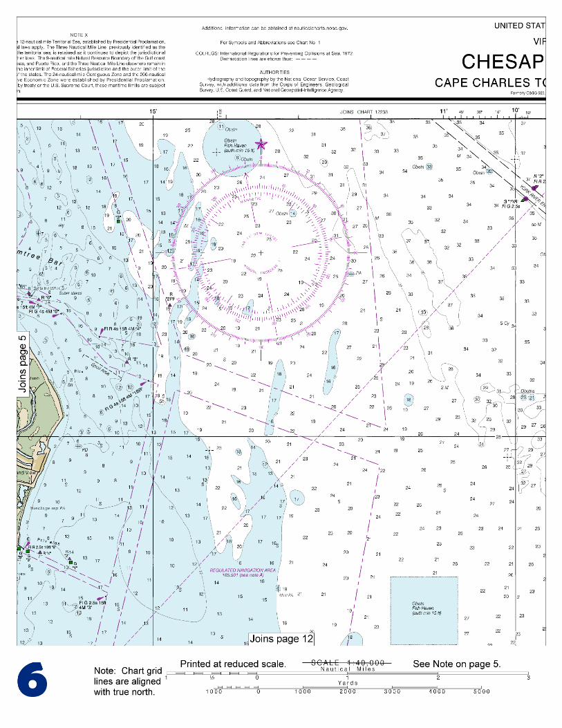
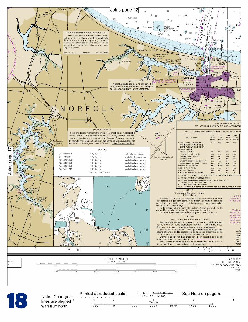
(Selected Excerpts from Coast Pilot) Cape Henry Light (36°55.6'N., 76°00.4'W.), 164 feet above the water, is shown from an octagonal, pyramidal tower, upper and lower half of each face alternately black and white, on the beach near the turn of the Chesapeake Bay Bridge extends from Cape Charles to a point 6 miles westward of Cape Henry. Channel buoys, lights, daybeacons and fog signals mark the openings at Chesapeake and Thimble Shoal Channels. At night the floodlighted tunnel houses are
more prominent than the lights marking the channels. The current velocity is 1.0 knot on the flood and 1.5 knots on the ebb in Chesapeake Bay Entrance.
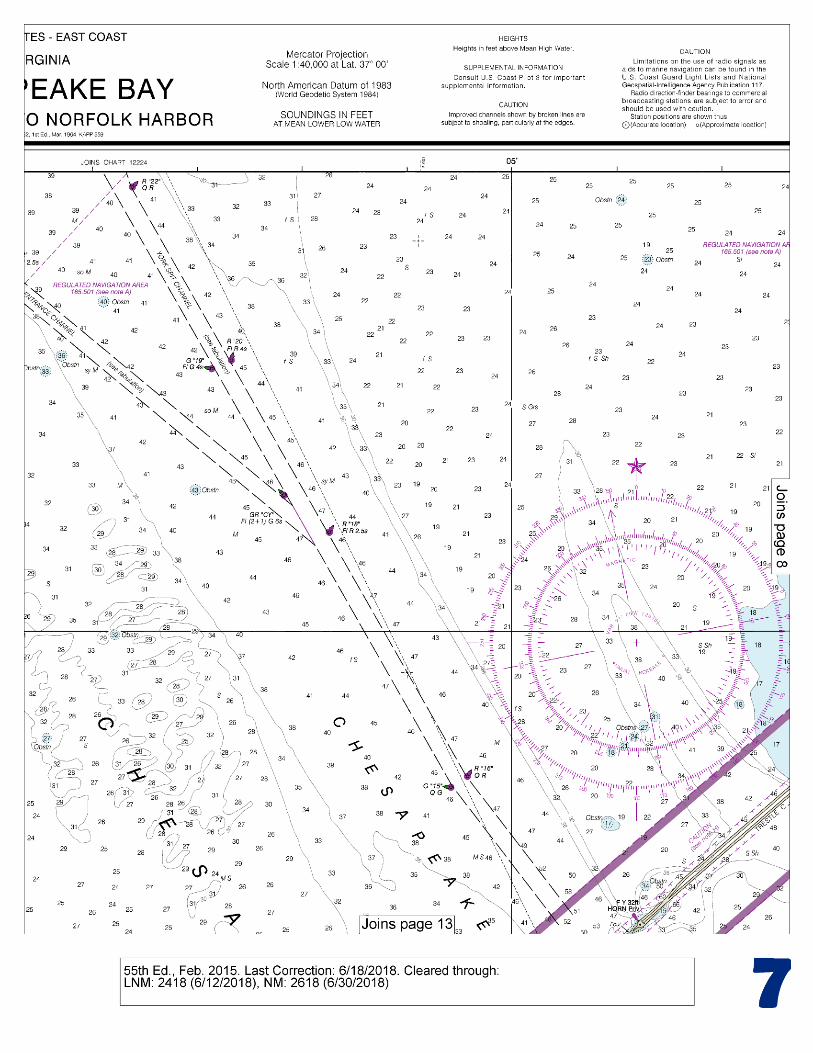
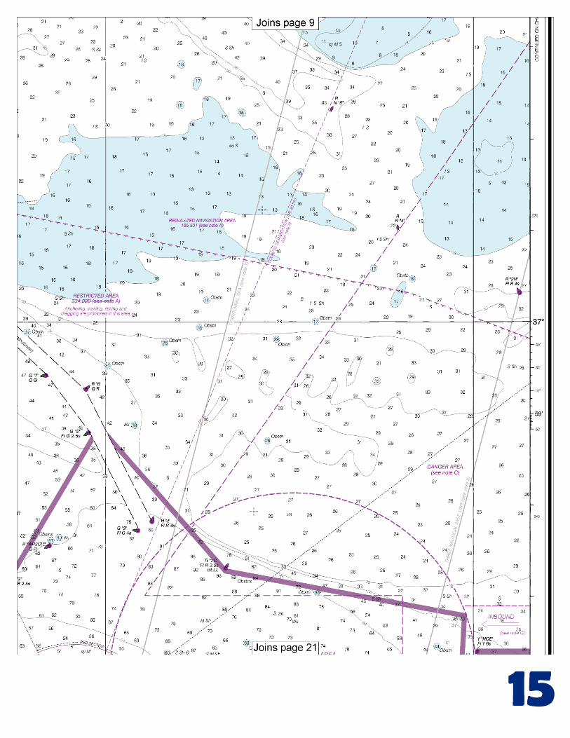
Thimble Shoal Channel is a Regulated Navigation Area and draft limitations apply. A vessel drawing less than 25 feet may not enter the channel, unless the vessel is crossing the channel. Lynnhaven Roads is used as an anchorage. The dumping ground in the western part has shoals and obstructions with depths as little as 11 feet; elsewhere depths are 20 to 28 feet. There are two small craft openings in the Chesapeake Bay Bridge-Tunnel south of Thimble Shoal Channel. Each span has a clearance of 21 feet. Lynnhaven Inlet. In 2000, the controlling depth in the entrance channel was 6½ feet. The inlet is marked by lights. Lynnhaven Bay has a turning basin south of the highway bridge over the inlet. The bay has depths of 1 to 10 ft. Caution.–The Chesapeake Bay Bridge-Tunnel complex has on several occasions suffered damage from vessels. In every case, adverse weather prevailed with accompanying strong winds from the northwest quadrant generally related to a frontal system. Weather deterioration in the lower bay is quite often sudden and violent and constitutes an extreme hazard to vessels operating or anchoring in this area. The proximity of the bridge-tunnel complex to main shipping channels and anchorages adds to the danger. Currents in excess of 3.0 knots can be expected in the area. Traffic Separation Scheme (Chesapeake Bay Entrance).–The scheme provides for inbound-outbound traffic lanes to enter or depart Chesapeake Bay from the northeastward and from the southeast-ward. (See chart 12221.) A precautionary area with a radius of 2 miles is centered on Chesapeake Bay Entrance Lighted Whistle Buoy CH (36°56'08"N., 75°57'27"W.). A racon is at the buoy. The northeasterly inbound-outbound traffic lanes are separated by a line of four fairway buoys on bearing 250°-070°. The outermost buoy in the line is 6.4 miles 313° from Chesapeake Light and the innermost buoy is 4.5 miles 074° from Cape Henry Light. The southeasterly approach is marked by Chesapeake Bay Southern Approach Lighted Whistle Buoy CB (36°49'00"N., 75°45'36"W.). A racon is on the buoy. The inbound/outbound traffic lanes are separated by a Deep-Water Route marked by lighted buoys on bearings 302°-122° and 317°-137°. The Deep-Water Route is intended for deep draft vessels and naval aircraft carriers entering or departing Chesapeake Bay. A vessel using the Deep-Water Route is advised to announce its intentions on VHF-FM channel 16 as it approaches Lighted Whistle Buoy CB on the south end, and Lighted Whistle Buoy CH on the north end of the route. All other vessels approaching the Chesapeake Bay Traffic Separation Scheme should use the appropriate inbound/outbound lanes of the northeasterly or southeasterly approaches. The Coast Guard advises that upon entering the traffic lanes, all inbound vessels are encouraged to make a security broadcast on VHF-FM channel 13, announcing the vessel's name, location, and intentions. Currents.–The current velocity is 1.0 knot on the flood and 1.5 knots on the ebb in Chesapeake Bay Entrance. (See the Tidal Current Tables for daily predictions.) Naval and general anchorages are south of Thimble Shoal Channel. (See 110.1 and 110.168, chapter 2, for limits and regulations.) Thimble Shoal Channel is a Regulated Navigation Area and draft limitations apply. A vessel drawing less than 25 feet may not enter the channel, unless the vessel is crossing the channel. (See 165.501, chapter 2, for limits and regulations.)
U.S. Coast Guard Rescue Coordination Center 24 hour Regional Contact for Emergencies
RCC Norfolk Commander 5th CG District (575) 398-6231 Norfolk, VA

G
NOAA’s navigation managers serve as ambassadors to the maritime community. They help identify navigational challenges facing professional and recreational mariners, and provide NOAA resources and information for safe navigation. For additional information, please visit nauticalcharts.noaa.gov/service/navmanagers
To make suggestions or ask questions online, go to nauticalcharts.noaa.gov/inquiry. To report a chart discrepancy, please use ocsdata.ncd.noaa.gov/idrs/discrepancy.aspx.
Lateral System As Seen Entering From Seaward on navigable waters except Western Rivers
PORT SIDE
ODD NUMBERED AIDS
GREEN LIGHT ONLY
FLASHING (2)
PREFERRED CHANNEL
NO NUMBERS – MAY BE LETTERED
PREFERRED CHANNEL TO
STARBOARD
TOPMOST BAND GREEN
PREFERRED CHANNEL
NO NUMBERS – MAY BE LETTERED
PREFERRED CHANNEL
TO PORT
TOPMOST BAND RED
STARBOARD SIDE
EVEN NUMBERED AIDS
RED LIGHT ONLY
FLASHING (2)
FLASHING FLASHING
OCCULTING GREEN LIGHT ONLY RED LIGHT ONLY OCCULTING QUICK FLASHING QUICK FLASHING
ISO COMPOSITE GROUP FLASHING (2+1) COMPOSITE GROUP FLASHING (2+1) ISO
"1"
Fl G 6s
G "9"
Fl G 4s
GR "A"
Fl (2+1) G 6s
RG "B"
Fl (2+1) R 6s
"2"
Fl R 6s
8
R "8"
Fl R 4s
LIGHT
G
C "1"
LIGHTED BUOY
G
"5"
GR
"U"
GR
C "S"
RG
N "C"
RG
"G"
LIGHT
6
R
N "6"
LIGHTED BUOY
R
"2
"
CAN DAYBEACON
CAN NUN NUN
DAYBEACON
For more information on aids to navigation, including those on Western Rivers, please consult the latest USCG Light List for your area.
These volumes are available online at http://www.navcen.uscg.gov
Navigation Managers Area of Responsibility
Northeast
Lt. Meghan McGovern
Northwest and
Pacific Islands
Crescent Moegling
Great Lakes Region
Tom Loeper
Chesapeake and
Delaware Bay
Steve Soherr
California
Jeff Ferguson
[email protected] Mid-Atlantic
Lt. Ryan Wartick
Alaska
Lt. Timothy M. Smith
Western Gulf Coast
Alan Bunn
Central Gulf Coast
Tim Osborn
[email protected] South Florida
Puerto Rico
U.S. Virgin Islands
Michael Henderson
Southeast
Kyle Ward
2
2 C U 5
1


VHF Marine Radio channels for use on the waterways:Channel 6 – Inter-ship safety communications.Channel 9 – Communications between boats and ship-to-coast.Channel 13 – Navigation purposes at bridges, locks, and harbors.Channel 16 – Emergency, distress and safety calls to Coast Guard and others, and to initiate calls to other
vessels. Contact the other vessel, agree to another channel, and then switch.Channel 22A – Calls between the Coast Guard and the public. Severe weather warnings, hazards to navigation and safety warnings are broadcast here.Channels 68, 69, 71, 72 and 78A – Recreational boat channels.
Getting and Giving Help — Signal other boaters using visual distress signals (flares, orange flag, lights, arm signals); whistles; horns; and on your VHF radio. You are required by law to help boaters in trouble. Respond to distress signals, but do not endanger yourself.
EMERGENCY INFORMATION
Distress Call Procedures
• Make sure radio is on.• Select Channel 16.• Press/Hold the transmit button.• Clearly say: “MAYDAY, MAYDAY, MAYDAY.”• Also give: Vessel Name and/or Description;Position and/or Location; Nature of Emergency; Number of People on Board.• Release transmit button.• Wait for 10 seconds — If no responseRepeat MAYDAY call.
HAVE ALL PERSONS PUT ON LIFE JACKETS!
This Booklet chart has been designed for duplex printing (printed on front and back of one sheet). If a duplex option is not available on your printer, you may print each sheet and arrange them back-to-back to allow for the proper layout when viewing.
QR
Quick ReferencesNautical chart related products and information - http://www.nauticalcharts.noaa.gov
Interactive chart catalog - http://www.charts.noaa.gov/InteractiveCatalog/nrnc.shtmlReport a chart discrepancy - http://ocsdata.ncd.noaa.gov/idrs/discrepancy.aspx
Chart and chart related inquiries and comments - http://ocsdata.ncd.noaa.gov/idrs/inquiry.aspx?frompage=ContactUs
Chart updates (LNM and NM corrections) - http://www.nauticalcharts.noaa.gov/mcd/updates/LNM_NM.html
Coast Pilot online - http://www.nauticalcharts.noaa.gov/nsd/cpdownload.htm
Tides and Currents - http://tidesandcurrents.noaa.gov
Marine Forecasts - http://www.nws.noaa.gov/om/marine/home.htm
National Data Buoy Center - http://www.ndbc.noaa.gov/
NowCoast web portal for coastal conditions - http://www.nowcoast.noaa.gov/
National Weather Service - http://www.weather.gov/
National Hurrican Center - http://www.nhc.noaa.gov/
Pacific Tsunami Warning Center - http://ptwc.weather.gov/
Contact Us - http://www.nauticalcharts.noaa.gov/staff/contact.htm
NOAA’s Office of Coast Survey The Nation’s Chartmaker
For the latest news from Coast Survey, follow @NOAAcharts
NOAA Weather Radio All Hazards (NWR) is a nationwide network of radio stations broadcasting continuous weather information directly from the nearest National Weather Service office. NWR broadcasts official Weather Service warnings, watches, forecasts and other hazard information 24 hours a day, 7 days a week. http://www.nws.noaa.gov/nwr/