Chehalis Basin Partnership - Washington · Chehalis Basin Partnership. i ... Frozen Foods Site ......
69
Multi-Purpose Water Storage Assessment Tetra Tech/KCM, Inc. 1917 First Avenue Seattle, WA 98101 Triangle Associates Prepared by In association with September 2003 Chehalis Basin Partnership
Transcript of Chehalis Basin Partnership - Washington · Chehalis Basin Partnership. i ... Frozen Foods Site ......

Multi-Purpose Water Storage Assessment
Tetra Tech/KCM, Inc.1917 First AvenueSeattle, WA 98101
Triangle Associates
Prepared byIn association with
September 2003
C h e h a l i s B a s i n
P a r t n e r s h i p

i
Chehalis Basin Water Storage Analysis TABLE OF CONTENTS
Title Page No.
Executive Summary ............................................................................... ES-1 Surface Water Storage.................................................................................. ES-2 Wetland Restoration Projects ...................................................................... ES-3 Aquifer Storage and Recovery...................................................................... ES-4 Programmatic Solutions............................................................................... ES-5
Forest Conservation/Restoration ........................................................ ES-5 Block Agricultural Drainages.............................................................. ES-6 Beaver Reintroduction......................................................................... ES-6 Low-Impact Development (LID).......................................................... ES-7 Programmatic Project Cost Estimate ................................................. ES-8
Non-Storage Projects .................................................................................... ES-8 Evaluation and Recommendations .............................................................. ES-9
1. Introduction..................................................................................... 1-1
2. Surface Water Storage................................................................... 2-1 General Description ..................................................................................... 2-1
New Reservoirs .................................................................................... 2-1 Modify Existing Reservoirs ................................................................. 2-2
Potential Projects ......................................................................................... 2-2 New Reservoirs .................................................................................... 2-2 Modify Existing Reservoirs ................................................................. 2-6
Cost Estimates .............................................................................................. 2-8 Feasibility...................................................................................................... 2-9
3. Wetland Restoration Projects ...................................................... 3-1 General Description ..................................................................................... 3-1 Potential Projects ......................................................................................... 3-1
Main Stem Scheuber Ditch Reconnection and Wetland Creation ................................................................................................ 3-2 South Fork Chehalis Revegetation and Wetland Creation, RM 0-5 .................................................................................................. 3-3 South Fork Chehalis Reconnections and Wetland Creation, South Fork and Main Stem Chehalis Confluence.............................. 3-5 Newaukum Revegetation and Wetland Creation, at Chehalis Confluence ............................................................................................ 3-6 Newaukum Revegetation and Wetland Creation, Stan Hedwell Park ...................................................................................................... 3-6 North Fork/South Fork Newaukum Confluence Connections and Wetland Creation.......................................................................... 3-8 Salzer Creek Revegetation and Wetland Creation, Chehalis Confluence ............................................................................................ 3-9

...TABLE OF CONTENTS
ii
Salzer Creek Reconnection and Wetland Creation, Frozen Foods Site........................................................................................................ 3-11 Salzer Creek Revegetation and Wetland Creation, RM 3.1 .............. 3-11 Salzer Creek Revegetation and Wetland Creation, RM 4.5 .............. 3-14
Water Storage Estimate .............................................................................. 3-14 Cost Estimate................................................................................................ 3-14 Feasibility...................................................................................................... 3-15
4. Aquifer Storage and Recovery..................................................... 4-1 General Description...................................................................................... 4-1 Potential Projects.......................................................................................... 4-1 Water Storage Estimates ............................................................................. 4-2 Cost Estimate................................................................................................ 4-3 Feasibility...................................................................................................... 4-5
5. Programmatic Solutions ............................................................... 5-1 General Description...................................................................................... 5-1
Forest Conservation/Restoration ........................................................ 5-1 Block Agricultural Drainages.............................................................. 5-2 Beaver Reintroduction......................................................................... 5-2 Low-Impact Development.................................................................... 5-4
Potential Projects.......................................................................................... 5-5 Forest Conservation/Restoration ........................................................ 5-5 Block Agricultural Drainage Tiles ...................................................... 5-5 Beaver Reintroduction......................................................................... 5-6 Low-Impact Development.................................................................... 5-7
Water Storage Estimate ............................................................................... 5-7 Cost Estimate................................................................................................ 5-8
6. Non-Storage Projects ..................................................................... 6-1 Washington Water Acquisition Program..................................................... 6-1 Water Rights Trades or Loans ..................................................................... 6-1 Irrigation Efficiency...................................................................................... 6-1 Water Conservation...................................................................................... 6-1 Recycled Wastewater.................................................................................... 6-1
7. Evaluation and Recommendations............................................. 7-1 Evaluation of Potential Projects .................................................................. 7-1
High-Yield Project Evaluation ............................................................ 7-1 Low-Yield Project Evaluation.............................................................. 7-3
Recommendations......................................................................................... 7-5 Aquifer Storage and Recovery............................................................. 7-5 Skookumchuck Dam Modifications..................................................... 7-5 Wynoochee Dam Modifications ........................................................... 7-6 Beaver Reintroduction......................................................................... 7-6 Forest Conservation............................................................................. 7-6 Agricultural Drainage Removal .......................................................... 7-6 Low-Impact Development.................................................................... 7-7 Wetland Restoration ............................................................................ 7-7

...TABLE OF CONTENTS
iii
Summary....................................................................................................... 7-7
References ................................................................................................ R-1

...TABLE OF CONTENTS
iv
LIST OF TABLES
No. Title Page No.
ES-1 Storage Characteristics for Potential New Reservoir Sites........................ ES-3 ES-2 Cost Estimates for Restoration Alternatives .............................................. ES-4 ES-3 Capacity and Costs of ASR Facilities in the U.S. ....................................... ES-5 ES-4 Estimated Cost of Programmatic Projects .................................................. ES-8
2-1 Storage Characteristics for Potential New Reservoir Sites........................ 2-3 2-2 New Reservoir Construction Cost Estimates .............................................. 2-9
3-1 Cost Estimates for Restoration Alternatives .............................................. 3-16
4-1 Capacity and Costs of ASR Facilities in the U.S. ....................................... 4-4
5-1 Estimated Cost of Programmatic Projects .................................................. 5-8
7-1 Summary of High-Yield Projects.................................................................. 7-1 7-2 Scoring of High-Yield Projects ..................................................................... 7-2 7-3 Summary of Wetland Projects...................................................................... 7-4 7-4 Cost/Benefit................................................................................................... 7-4
LIST OF FIGURES
No. Title Page No.
2-1 Potential Sites for New Reservoirs .............................................................. 2-3 2-2 Existing Reservoirs with Potential for Storage Projects ............................ 2-7
3-1 Potential Wetland Restoration Projects ...................................................... 3-2 3-2 Main Stem Scheuber Ditch Reconnection and Wetland Creation, RM 0 - 5 ......................................................................................................... 3-3 3-3 South Fork Chehalis Revegetation and Wetland Creation, RM 0 - 5 ....... 3-4 3-4 South Fork Chehalis Reconnections and Wetland Creation, South Fork and Main Stem Chehalis Confluence.................................................. 3-5 3-5 Newaukum Revegetation and Wetland Creation, at Chehalis Confluence..................................................................................................... 3-7 3-6 Newaukum Revegetation and Wetland Creation, Stan Hedwell Park...... 3-8 3-7 North Fork/South Fork Newaukum Confluence Connections and Wetland Creation.......................................................................................... 3-9 3-8 Salzer Creek Revegetation and Wetland Creation, Chehalis Confluence..................................................................................................... 3-10 3-9 Salzer Creek Reconnection and Wetland Creation, Frozen
Foods Site ...................................................................................................... 3-12

...TABLE OF CONTENTS
v
3-10 Salzer Creek Revegetation and Wetland Creation, RM 3.1 ....................... 3-13 3-11 Salzer Creek Revegetation and Wetland Creation, RM 4.5 ....................... 3-15
4-1 Newaukum Artesian Aquifer ....................................................................... 4-2

ES-1
EXECUTIVE SUMMARY
This report documents the results of a multipurpose water storage analysis conducted by the Tetra Tech/KCM and Triangle Associates consulting team for Grays Harbor County on behalf of the Chehalis Basin Partnership. This study was done to support the Partnership in developing a Watershed Management Plan for the Chehalis River Basin under the State of Washington’s Watershed Management Act (RCW 90.82), also known as a “2514 Watershed Plan.” Under the 2514 planning process, the Partnership elected to address four elements: water quantity, water quality, habitat, and instream flow. This report summarizes the survey-level study to examine multipurpose water storage options that may be a feasible and appropriate part of watershed management in the Chehalis.
Like most basins in western Washington, the Chehalis basin receives more than sufficient rainfall to meet both instream flow requirements and water demands during the winter. In the summer, however, water demand is at a peak while rainfall is at a minimum, and summer instream flows can drop to levels that hinder salmonid production as well as reduce water quality (Smith et al., 2001).
Within the basin, snowmelt influence is minimal and stream flows largely depend on precipitation (Smith et al., 2001). Since most rivers in the Chehalis Basin are not fed by melting alpine snow, groundwater in the basin plays an important function. Wintertime rainfall recharges the basin’s aquifers, which effectively store and release the water in the drier months. This groundwater release is defined as base flow and in the summer accounts for most of the instream flow of a stream.
As the population in the basin has grown, groundwater throughout the basin has been tapped for consumption. In addition, land use practices such as forest clear-cutting and the filling in of wetlands, as well as the growth of impervious surfaces, disturb the normal hydrologic regime by causing an increase in runoff and a decrease in the opportunity for groundwater recharge. This combined demand on groundwater supplies and reduction of recharge has resulted in lower than average base flow contributions to the basin’s rivers and streams (Smith et al., 2001).
The goal of the multipurpose water storage analysis was to identify potential projects to store excess wintertime runoff for use in the drier summer months to increase instream flows, either by providing additional water for consumption or by directly augmenting instream flows. This was a survey-level study to determine projects that warrant further consideration and was based on a review of available existing information. No new analyses were conducted for this report, so the level of detail for specific projects in this report depended on the information available. In some instances, projects would require considerably more investigation before a final determination could be made as to their feasibility.
The most important information that must be developed before a final determination of projects can be established is an analysis of the basin’s overall water requirements for the future and where the water is needed. Once this is known, the scale of projects can be estimated and used to help refine the selection process. At the time of this report, studies have indicated that regulatory minimum flows are not being met in several rivers and streams in the basin. However, until a consensus can be reached on the instream flow
ES-2
needs and projected future consumptive requirements, no definitive conclusions can be reached.
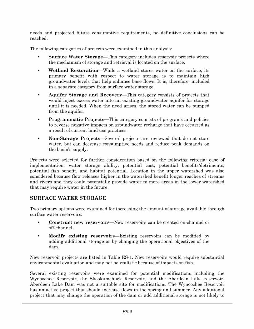
The following categories of projects were examined in this analysis:
• Surface Water Storage—This category includes reservoir projects where the mechanism of storage and retrieval is located on the surface.
• Wetland Restoration—While a wetland stores water on the surface, its primary benefit with respect to water storage is to maintain high groundwater levels that help enhance base flows. It is, therefore, included in a separate category from surface water storage.
• Aquifer Storage and Recovery—This category consists of projects that would inject excess water into an existing groundwater aquifer for storage until it is needed. When the need arises, the stored water can be pumped from the aquifer.
• Programmatic Projects—This category consists of programs and policies to reverse negative impacts on groundwater recharge that have occurred as a result of current land use practices.
• Non-Storage Projects—Several projects are reviewed that do not store water, but can decrease consumptive needs and reduce peak demands on the basin’s supply.
Projects were selected for further consideration based on the following criteria: ease of implementation, water storage ability, potential cost, potential benefits/detriments, potential fish benefit, and habitat potential. Location in the upper watershed was also considered because flow releases higher in the watershed benefit longer reaches of streams and rivers and they could potentially provide water to more areas in the lower watershed that may require water in the future.
SURFACE WATER STORAGE
Two primary options were examined for increasing the amount of storage available through surface water reservoirs:
• Construct new reservoirs—New reservoirs can be created on-channel or off-channel.
• Modify existing reservoirs—Existing reservoirs can be modified by adding additional storage or by changing the operational objectives of the dam.
New reservoir projects are listed in Table ES-1. New reservoirs would require substantial environmental evaluation and may not be realistic because of impacts on fish.
Several existing reservoirs were examined for potential modifications including the Wynoochee Reservoir, the Skookumchuck Reservoir, and the Aberdeen Lake reservoir. Aberdeen Lake Dam was not a suitable site for modifications. The Wynoochee Reservoir has an active project that should increase flows in the spring and summer. Any additional project that may change the operation of the dam or add additional storage is not likely to

ES-3
be implemented. The Skookumchuck Dam also has an active project that may have the opportunity for increasing storage 8500 acre-feet above what is called for in the current project. At the very least, even though the project is intended to address flooding issues, negotiations with the Federal Energy Regulatory Commission (FERC) should emphasize the need to consider low-flow augmentation as part of operation of the dam.
TABLE ES-1. STORAGE CHARACTERISTICS FOR POTENTIAL NEW RESERVOIR SITES
Site Name Drainage Basin
Dam Height (feet)
Storage Capacity
(acre-feet)
Surface Area
(acres)
Drainage Area (sq.
miles)
Three Month Release
Ratea (cfs)
Alpha Creek Newaukum River 220 54,000 54 26.5 295
Above Hanlon S. Fork Chehalis River 100 7,000 269 6.09 38
Lake Creek S. Fork Chehalis River 100 40,000 1037 7.6 219
Lost Creek S. Fork Chehalis River 60 6,000 349 6.1 33
Charlies Hump Chehalis River 240 95,000 1057 68.9 520
Little Elk Creek
Elk Creek 75 9,000 399 5.8 49
Bunker Creek Deep Creek 40 6,000 478 15.2 33
Upper Deep Creek
Deep Creek 25 3,000 120 1.6 16
a. Three-month release rate is the rate at which the reservoir storage volume would be depleted at a constant discharge over a three-month period.
WETLAND RESTORATION PROJECTS
This category of storage projects addresses ways to restore existing or historical wetland areas. Wetland restoration that might occur as the result of removing agricultural drainages is addressed in the category of programmatic projects.
Wetland restoration encompasses many types of projects, including increasing habitat diversity, riparian revegetation, and floodplain reconnection. The projects presented in this report would increase the volume of storage in a wetland, increase the wet area of a wetland, or increase the time that a wetland contains water. Such projects include reconnecting overbank areas to the floodplain, inundating historical wetland areas, and increasing the water depth in existing wetlands.
The wetland projects included here were taken from Chehalis River at Centralia General Reevaluation Report/Environmental Impact Statement (Tetra Tech, 2001). Other sources examined for potential projects included Salmon and Steelhead Habitat Limiting Factors (WRIAs 22 and 23), Chehalis Basin Plan for Habitat Restoration (CBP, 2001), and Chehalis Basin Level 1 Assessment (Envirovision, 2000). It should be noted that these projects do not represent all of the available projects in the basin; they represent only suitable projects

ES-4
found in the examined references. Additional work should be done to examine additional projects on a basin-wide scale. The projects considered are listed in Table ES-2.
TABLE ES-2. COST ESTIMATES FOR RESTORATION ALTERNATIVES.
Site Construction
Cost
Total Project Area
(acres)
Wetlands Created (acres)
Cost per Acre of Wetland
Main Stem Scheuber Ditch $6,960,100 75 12 $580,000
SF Chehalis, RM 0-5 $11,912,000 57 <10 <1,200,000
SF Chehalis, Chehalis Confluence $1,363,400 13 8 $170,000
Newaukum, Chehalis Confluence $1,352,900 8 5 $270,00
Newaukum, Stan Hedwall Park $1,429,800 10 <1 >$1,430,000
NF/SF Newaukum Confluence $2,320,000 31 10 $232,000
Salzer Creek, Chehalis Confluence $324,000 8 <1 >$324,000
Salzer Creek, Frozen Foods Site $500,200 4 <1 >$500,000
Salzer Creek, RM 3.1 $1,445,400 28 <1 >$1,445,000
Salzer Creek, RM 4.5 $1,820,100 17 10 $182,000
AQUIFER STORAGE AND RECOVERY
Aquifer Storage and Recovery (ASR) is a process by which an aquifer is recharged with excess runoff or groundwater which is stored until it is needed at a later time. The recharge process typically occurs by means of an injection well. Infiltration ponds can also be used to recharge the aquifer if the topography and geology are suitable. In the Chehalis Basin, ASR would most likely use a well field for both the recharge and extraction of the water.
Compared to surface water storage projects, ASR has little impact on fish and wildlife habitat. The main impact on fish would likely occur at the point of withdrawal. Because withdrawals from streams or rivers for recharge would occur during wet winter months, the impact on instream flows would be minimal. Other environmental impacts may be caused by the well field and distribution infrastructure, but the infrastructure necessary for ASR generally is minimal.
Preliminary investigations into the watershed’s aquifers indicated that the most promising aquifer for ASR is the Newaukum Artesian aquifer. An artesian aquifer is a vertically confined aquifer whose water is under pressure. The Newaukum Artesian aquifer underlies an area of approximately 25 square miles; the water is stored in sedimentary rocks southeast of the City of Centralia. (See Figure 14.) At many places within this aquifer, well yields of several hundred gallons per minute are possible (Weigle and Foxworthy, 1962).

ES-5
Several factors, including the presence of a confining layer that would inhibit contamination, the well yields, and the aquifer’s proximity to major population areas (Napavine, Centralia, and Chehalis) make it a candidate for further study.
Considerable additional study of the aquifer is needed before an ASR pilot project could be implemented. The characteristics of the aquifer would have to be evaluated in greater detail, including the storage amount (specific storage) that the aquifer could hold and the rate at which water travels in the subsurface. These characteristics determine the rate at which water can be injected and recovered.
Table ES-3 shows the costs of current ASR projects around the United States. Similar costs would be expected to implement an ASR project in the Chehalis Basin.
TABLE ES-3. CAPACITY AND COSTS OF ASR FACILITIES IN THE U.S.
Site
Water Recovered per Day (MGDa) Capital Costb
Cost per Water Recovered per Day ($/MGD)c
Kerrville, Texas 1.8 $987,000 $548,000
Centennial, Colorado 0.7 $410,000 $586,000
Seattle, Washington 5.1 $1,670,000 $327,000
Swimming River, New Jersey 1.7 $600,000 $353,000
Source: Landauer, 1998. a. MGD = million gallons per day b. Does not include operation and maintenance costs c. Capital cost divided by water recovered per day
PROGRAMMATIC SOLUTIONS
The following projects are aimed at promoting basinwide infiltration to promote groundwater recharge which would increase summer base flows:
• Provide forest conservation/restoration
• Block agricultural drainages
• Support beaver populations
• Encourage low-impact development
Forest Conservation/Restoration
Forests are important elements in preserving the hydrologic balance as well as the ecological balance of the basin. Forest products are a large industry in the basin and forest practices should continue to be closely monitored and examined with respect to the impact they have on the basin’s hydrology. This has been an ongoing issue and is likely to remain one into the future.

ES-6
The recommended project has two components. First, a staff position would be created to serve as a “forest watershed steward.” This person would monitor forest practices activities throughout the Chehalis Watershed to provide a watershed-scale view of forestry activities. Part of the steward’s job would be to document successes and areas needing improvement in forest land management. This person could also provide a liaison role between forest land managers and the Chehalis Basin Partnership.
The second component of recommended actions under Forest Conservation/ Restoration is further research into the effects of decreased forest cover on infiltration, groundwater, and base flow in the basin. By quantifying the effects of deforestation and forest harvesting on base flows, new regulations can be fairly developed and administered or the proper mitigation can be specified.
Block Agricultural Drainages
Agricultural drainage is the removal of excess water from the soil surface or the soil profile of cropland by gravity or by artificial means. Drainages can either be surface, subsurface, or a combination of the two. Surface drainages generally consist of ditches that convey excess water away from the fields. Curved tiles or perforated pipes buried just below the ground surface are the most common techniques of subsurface drainage. As water infiltrates below the root zone of plants the tiles or pipes intercept the water and convey it off site. Clay or ceramic tiles are generally associated with older drainages before plastic pipe became easily accessible and are often still found on land that is no longer in agricultural production.
The recommended project includes the following elements:
• Establish a public information campaign that might consist of mailings and workshops focused on the effects of drainages and of the opportunities available.
• Establish a database and compile data about known drainage systems. Methods for identifying drainages include examining aerial photographs, examining Nationa Resource Conservation Service (NRCS) records, and interviewing landowners. The database would serve as a means to track the extent of known drainage systems, their condition, and the current land use.
• Landowners could also be encouraged to voluntarily block existing drainages no longer needed or request assistance from their County in blocking drainages. Further investigation into the incentives, benefits, and funding sources available to landowners is also necessary.
Beaver Reintroduction
Beaver populations, which historically were common and abundant throughout the basin, have been severely reduced by trapping and hunting. Beavers are important regulators of aquatic and terrestrial ecosystems, with effects far beyond their food and space requirements. Beavers modify stream morphology and hydrology by cutting wood and building dams. This in turn influences a variety of biological responses within and adjacent to stream channels.

ES-7
Beavers are often viewed as a nuisance species by landowners because of the impacts they have on streams. In addition, current land use is often not compatible with the effects beavers may have on land. As a result, efforts to import beaver into the area or to explicitly expand the beaver population could be highly contentious and are not recommended. However, many people may not be aware of the important role beavers play in the ecosystem. Therefore, the recommended alternative contains the following elements:
• Emphasize the benefits of beavers in public information materials
• Encourage landowners not to automatically remove beavers when they are found in an area
• Establish a relocation program for nuisance beavers
Rather than endorse a program that would explicitly expand the existing beaver population, efforts to restore riparian areas could include elements that would support beaver. For example, by ensuring an adequate food supply with willow stakes and coniferous plantings, the beaver population should naturally expand to fill habitat over time. This would essentially be restoring a creek or stream to its natural condition—a condition that has historically served as habitat for beavers and other animal populations. The ultimate consequence of this restoration would be hydrologic improvements that would promote instream flows.
Low-Impact Development (LID)
Extensive regional and national research shows a clear link between development in a watershed and degradation of aquatic resources. Conventional stormwater management practices have not always proven successful at fully mitigating for the effects of this development. Since the Chehalis Basin is primarily forest covered and development densities tend to be low outside of the basin’s cities, a policy of LID could be implemented to reduce the impact from future development in the basin.
LID policies could be adopted as part of the construction permitting process in the basin. Adopting a low-impact development program would require the cooperation of all or most of the municipal jurisdictions in the basin. Currently, Thurston County has a policy of LID in its stormwater regulations; however, the other counties do not. A model ordinance should be developed that could be modified or directly adopted by municipalities. In addition, the cost benefits of LID should be documented and made available to the public as well as to developers. Given its broad participation, the Chehalis Basin Partnership would be a good forum to develop the coordination needed to initiate an LID program.
A method that could be used in existing developments is to minimize the amount of impervious surface that is directly connected to the storm drain network—referred to as the effective impervious area. One simple and inexpensive method to reduce effective impervious area is to disconnect downspouts that are connected to the drainage collection system and redirect them to pervious areas where the runoff can infiltrate. This could be done by individual property owners if they are made aware of the benefits and are instructed how to do it without concentrating flow and instigating new problems. A public information program should include the effects of impervious area and provide suggestions

ES-8
for how individuals may mitigate some of these effects. Such an effort would support the CBP goal of encouraging and using volunteer implementation approaches where possible.
Programmatic Project Cost Estimate
Table ES-4 summarizes estimated costs for the programmatic solutions. The costs listed are for the recommended projects and are based on a 5-year time line. These costs include public information and policy activities but do not include costs for specific on-the-ground projects that might be developed. For example, no costs are estimated for blocking any specific agricultural drainages. Some planning level cost estimates have been developed previously for on-the-ground projects. For example, in the General Reevaluation Report (GRR) Restoration Plan (Tetra Tech, 2002) the cost for removing drain tiles from 1,000 acres was estimated to be $11,200,000. A large-scale forest restoration project over the entire basin would likely cost more than $10,000,000.
TABLE ES-4. ESTIMATED COST OF PROGRAMMATIC PROJECTS
Project Estimated Cost
Block Agricultural Drainages $207,000
Low-Impact Development $120,000
Beaver Reintroduction $170,000
Forest Conservation/Restoration $300,000
NON-STORAGE PROJECTS
Projects or programs that do not involve water storage but that could be implemented to help maintain minimum instream flows are discussed briefly below.
• Washington Water Acquisition Program: This is a voluntary program to increase stream flows in watersheds with vulnerable salmon and trout populations. Program participants are holders of water rights who sell or lease to the state all or part of their water right or donate all or part of the water right on a permanent or temporary basis.
• Water Rights Trades or Loans: This voluntary program would be similar to the Water Acquisition Program, but instead of water rights being sold or leased to the state, they would be traded or leased to other private entities. This could have the effect of meeting water demand in areas that lack further water rights without any increase in overall water rights in the basin.
• Irrigation Efficiency: Increasing agricultural irrigation efficiency could reduce the amount of withdrawal from surface water and groundwater sources, leading to higher instream flows. Grants administered by local conservation districts are

ES-9
available to assist with increasing efficiency, based on demonstrated need and environmental benefit.
• Water Conservation: Increased water conservation reduces the amount of water being withdrawn from surface water and groundwater sources, leading to higher instream flows. Adjusting water rate structures can promote conservation by charging more for water usage above a specified volume. Such a rate structure would be designed to encourage larger water consumers to use water more efficiently.
• Recycled Wastewater: Recycled wastewater (gray water) can be used in lieu of other water withdrawals for the irrigation of agricultural or landscaped areas. The City of Chehalis is currently designing a regional wastewater treatment plant that incorporates recycled wastewater. This project could be used as a model for future treatment plants.
EVALUATION AND RECOMMENDATIONS
Projects evaluated were divided into high-yield and low-yield categories. This classification system was used to compare projects with similar merits. The high-yield category compares projects that have the potential to provide significant quantities of stored water. The low-yield category compares projects that will not provide large quantities of stored water but are very beneficial to the overall health of the watershed. The projects in the high-yield category include the new reservoir projects, existing reservoir modifications, and ASR. The projects in the low-yield category include the wetland restoration projects and the programmatic projects.
The projects and programs recommended for further investigation or implementation are listed below. All of these projects will require additional detailed feasibility assessment if pursued. Of particular concern at this time is the connection of surface water and the propagation of mosquitoes that transmit the West Nile virus.
• Aquifer Storage and Recovery
• Skookumchuck Dam Modifications
• Wynoochee Dam Modifications
• Beaver Reintroduction
• Forest Conservation
• Agricultural Drainage Removal
• Low-Impact Development
• Wetland Restoration
1-1
1. INTRODUCTION
This report documents the results of a multipurpose water storage analysis conducted by the Tetra Tech/KCM and Triangle Associates consulting team for Grays Harbor County on behalf of the Chehalis Basin Partnership. This study was done to support the Partnership in developing a Watershed Management Plan for the Chehalis River Basin under the State of Washington’s Watershed Management Act (RCW 90.82), also known as a “2514 Watershed Plan.” Under the 2514 planning process, the Partnership elected to address four elements: water quantity, water quality, habitat, and instream flow. This report summarizes the survey-level study to examine multipurpose water storage options that may be a feasible and appropriate part of watershed management in the Chehalis.
Like most basins in western Washington, the Chehalis basin receives more than sufficient rainfall to meet both instream flow requirements and water demands during the winter. In the summer, however, water demand is at a peak while rainfall is at a minimum, and summer base flows can drop to levels that hinder salmonid production as well as reduce water quality (Smith et al., 2001).
Within the basin, snowmelt influence is minimal and stream flows depend largely on precipitation (Smith et al., 2001). Since most rivers in the Chehalis Basin are not fed by melting alpine snow, groundwater in the basin plays an important function. Wintertime rainfall recharges the basin’s aquifers, which effectively store the water and release it in the drier months. This groundwater release is defined as base flow and in the summer accounts for most of the instream flow of a stream.
As the population in the basin has grown, groundwater throughout the basin has been tapped for consumption. In addition, land use practices such as forest clear-cutting and the filling in of wetlands, as well as the growth of impervious surfaces, disturb the normal hydrologic regime by causing an increase in runoff and a decrease in the opportunity for groundwater recharge. This combined demand on groundwater supplies and reduction of recharge has resulted in lower than average base flow contributions to the basin’s rivers and streams (Smith et al., 2001).
The goal of the multipurpose water storage analysis was to identify potential projects to store excess wintertime runoff for use in the drier summer months to increase instream flows, either by providing additional water for consumption or by directly augmenting instream flows. This was a survey-level study to determine projects that warrant further consideration and was based on a review of available existing information. No new analyses were conducted for this report, so the level of detail for specific projects in this report depended on the information available. In some instances, projects would require considerably more investigation before a final determination could be made as to their feasibility.
The most important information that must be developed before a final determination of projects can be established is an analysis of the basin’s overall water requirements for the future and where the water is needed. Once this is known, the scale of projects can be estimated and used to help refine the selection process. At the time of this report, studies

Chehalis Basin Water Storage Analysis…
1-2
have indicated that regulatory minimum flows are not being met in several rivers and streams in the basin. However, until a consensus can be reached on the instream flow needs and projected future consumptive requirements, no definitive conclusions can be reached.
The following categories of projects were examined in this analysis:
• Surface Water Storage—This category includes reservoir projects where the mechanism of storage and retrieval is located on the surface.
• Wetland Restoration—While a wetland stores water on the surface, its primary benefit with respect to water storage is to maintain high groundwater levels that help enhance base flows. It is, therefore, included in a separate category from surface water storage.
• Aquifer Storage and Recovery—This category consists of projects that would inject excess water into an existing groundwater aquifer for storage until it is needed. When the need arises, the stored water can be pumped from the aquifer.
• Programmatic Projects—This category consists of programs and policies to reverse negative impacts on groundwater recharge that have occurred as a result of current land use practices.
• Non-Storage Projects—Several projects are reviewed that do not store water, but can decrease consumptive needs and reduce peak demands on the basin’s supply.
Projects were selected for further consideration based on the following criteria: ease of implementation, water storage ability, potential cost, potential benefits/detriments, potential fish benefit, and habitat potential. Location in the upper watershed was also considered because flow releases higher in the watershed benefit longer reaches of streams and rivers and they could potentially provide water to more areas in the lower watershed that may require water in the future.
2-1
2. SURFACE WATER STORAGE
GENERAL DESCRIPTION
There are two primary options for increasing the amount of storage available through surface water reservoirs:
• Construct new reservoirs—New reservoirs can be created on-channel or off-channel.
• Modify existing reservoirs—Existing reservoirs can be modified by adding additional storage or by changing the operational objectives of the dam.
New Reservoirs
New reservoirs can be divided into two categories based on the location of the dam with respect to the river or stream: on-channel and off-channel. An on-channel dam is sited directly in the channel of a river or major stream and is filled directly by flow from the upstream watershed. An off-channel dam is outside the channel of the river or stream. Runoff from the upstream watershed is usually too low to maintain a reservoir, so most of the water for off-channel reservoirs is diverted from the main channel by gravity or by pumping. Because water must be piped or pumped to off-channel reservoirs, they are usually more expensive than on-channel reservoirs.
The benefits and drawbacks of surface water reservoirs are well documented. For on-channel reservoirs benefits include the following:
• They provide the potential for flood control.
• The water supply is located at the site.
• River valleys are capable of storing a large volume of water.
Drawbacks of on-channel reservoirs include the following:
• They pose a barrier to fish passage.
• Sediment from the river can fill in the reservoir, decreasing storage over time.
• Creation of the reservoir often requires relocation of people and infrastructure.
• Extensive permitting and mitigation are required.
• The reservoirs have a significant overall environmental impact.
The advantages of off-channel reservoirs include the following:
• They do not generally represent a significant barrier to fish passage.

Chehalis Basin Water Storage Analysis…
2-2
• Because the location is flexible, the reservoir can be sited in an area where it would have less environmental impact.
• Off-channel dams require smaller spillways and outlet works than on-channel dams.
The disadvantages of off-channel reservoirs include the following:
• Extensive conveyance infrastructure is required to get water into and out of the reservoir.
• Reservoir leakage and seepage can be a significant problem depending geology and groundwater.
• Off-channel dams are generally more expensive than on-channel dams.
Potential new-reservoir projects reviewed in this report were identified in Southwestern Washington River Basins Type IV Survey (SCS 1974). Some of the projects are on minor streams or creeks, but none are considered to be off-channel.
Modify Existing Reservoirs
Modifying an existing reservoir has several significant advantages over creating a new reservoir:
• The dam is already in place, removing the issue of blocking a free-flowing river.
• Environmental impacts are smaller than those of a new dam.
• The downstream river is already subjected to a regulated flow regime.
• The incremental cost of adding storage is typically much lower than for new dam projects.
POTENTIAL PROJECTS
New Reservoirs
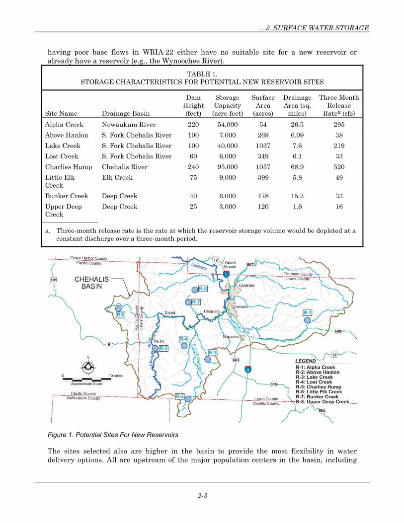
In 1974, the U.S. Soil Conservation Service (SCS) published the Southwestern Washington River Basins Type IV Survey, which identified 53 potential reservoir sites in the Chehalis basin. Eight of these sites were identified for further analysis and are described in this report, based on available information. The selection process took into account the location, existing land use, estimated potential storage, and the presence of priority fish species habitat. Table 1 summarizes the location and potential storage of each of the candidate reservoir sites. Figure 1 shows the location of each site. Not all streams that have need of water were found to have a suitable reservoir site (e.g., the Black River).
Most of the sites are in the central to southwestern portion of the upper basin (WRIA 23); none are in the lower basin (WRIA 22). This is partly because streams with low base flows are primarily in the upper basin. According to Smith et al. (2001), 22 of the 25 streams that are closed to further water appropriations are in WRIA 23. The streams identified as
…2. SURFACE WATER STORAGE
2-3
having poor base flows in WRIA 22 either have no suitable site for a new reservoir or already have a reservoir (e.g., the Wynoochee River).
TABLE 1. STORAGE CHARACTERISTICS FOR POTENTIAL NEW RESERVOIR SITES
Site Name Drainage Basin
Dam Height (feet)
Storage Capacity
(acre-feet)
Surface Area
(acres)
Drainage Area (sq.
miles)
Three Month Release
Ratea (cfs)
Alpha Creek Newaukum River 220 54,000 54 26.5 295
Above Hanlon S. Fork Chehalis River 100 7,000 269 6.09 38
Lake Creek S. Fork Chehalis River 100 40,000 1037 7.6 219
Lost Creek S. Fork Chehalis River 60 6,000 349 6.1 33
Charlies Hump Chehalis River 240 95,000 1057 68.9 520
Little Elk Creek
Elk Creek 75 9,000 399 5.8 49
Bunker Creek Deep Creek 40 6,000 478 15.2 33
Upper Deep Creek
Deep Creek 25 3,000 120 1.6 16
a. Three-month release rate is the rate at which the reservoir storage volume would be depleted at a constant discharge over a three-month period.
Figure 1. Potential Sites For New Reservoirs
The sites selected also are higher in the basin to provide the most flexibility in water delivery options. All are upstream of the major population centers in the basin, including

Chehalis Basin Water Storage Analysis…
2-4
Centralia, Chehalis, Hoquiam and Aberdeen, and could act as a supplemental source of water for a variety of locations and uses.
The sites also all avoid known critical fisheries habitat. Priority habitat was determined using the Washington Department of Fish and Wildlife’s GIS database. To avoid the environmental impacts and related difficulties in constructing a dam in a priority habitat area, none of the selected dam sites are located in those areas.
In the original SCS study, the potential reservoir sites were identified using only USGS topographic maps with 40-foot contour intervals. For this study, the locations of the potential reservoirs were confirmed along with their approximate storage characteristics, but no further analysis was done to assess the suitability of these sites for reservoirs. Significant additional study would be needed to fully ascertain whether a particular reservoir would be feasible or even if a site would be a suitable location for a dam. A brief description of the selected sites’ characteristics is presented below.
Alpha Creek
The Alpha Creek site is the only potential reservoir site in the eastern portion of the upper basin. It is on a tributary to the upper portion of the South Fork Newaukum River. The site is at approximately river mile (RM) 64. According to Southwestern Washington River Basins Type IV Survey, this site has a potential storage capacity of 54,000 acre-feet, which corresponds to an average discharge of 295 cubic feet per second (cfs) over a three-month period.
According to available maps and photos, land use in the area is mixed forest that is being actively logged. Several logging roads in the vicinity of the site could provide access, but there are no permanent structures.
The lower Newaukum River has been identified as a stream where the minimum regulatory flows are not being met. In the Newaukum subbasin, flows have failed to meet minimum requirements an average of 59 days per year, contributing to the closure of several creeks to further water withdrawals (Smith et al. 2001).
This reservoir site has the best initial characteristics of all the sites examined for this study: it is upstream of a river reach that is in need of flow augmentation; it is upstream of major population centers; its reservoir pool area is relatively small (54 acres); the amount of storage available is significant (54,000 acre-feet); it appears to be upstream of critical fisheries habitat; and there do not appear to be any impacts to existing infrastructure. Still, much further study would be required to properly evaluate the site’s potential.
Above Hanlon
This site is on the South Fork of the Chehalis River approximately 41 miles upstream from the City of Chehalis. According to the Southwestern Washington River Basins Type IV Survey, the reservoir would cover almost 269 acres and could provide approximately 7,000 acre-feet of storage. A reservoir of this size could provide almost 38 cfs over a three-month period.

…2. SURFACE WATER STORAGE
2-5
According to available maps and photos, the land use in the area is mixed forest and is extensively logged. Access to the site is available through logging roads that run through the area. There are no permanent structures at the site.
Lake Creek
Lake Creek is tributary to the South Fork of the Chehalis River, approximately 41 miles upstream of the City of Chehalis. The surface area of the reservoir for this site would be extensive. According to the Southwestern Washington River Basins Type IV Survey, the reservoir would cover almost 1,000 acres and provide approximately 40,000 acre-feet of storage. A reservoir of this size could provide almost 220 cfs over a three-month period. However, the drainage area of this basin is small and it is unlikely that the full storage capacity could be recharged in a year.
According to available maps and photos, the land use in the area is mixed forest that includes several wetland areas. There is no existing access to this site. This site has the potential to provide a significant amount of storage; however, given that much of the area consists of wetlands that are in good condition and that the size of the drainage area is small, this site was removed from further consideration.
Lost Creek
Lost Creek is tributary to Stillman Creek, which is tributary to the South Fork of the Chehalis River. Stillman Creek enters the South Fork at approximately RM 5. The dam would be located at the bottom of Lost Valley and would essentially flood the valley. According to Southwestern Washington River Basins Type IV Survey, this site has a potential storage capacity of 6,000 acre-feet, which corresponds to an average discharge of 33 cfs over a three-month period. Several existing structures and Lost Valley Road are located within the estimated area of inundation.
Charlies Hump
This reservoir would be on the Chehalis River, approximately 33 miles upstream of the City of Chehalis. According to the Southwestern Washington River Basins Type IV Survey, the reservoir would cover over 400 acres and could provide approximately 95,000 acre-feet of storage. A reservoir of this size could provide approximately 520 cfs over a three-month period. The reservoir surface area would be extensive, covering more than one square mile. The area has access from several logging roads. Existing land use is mixed forest and the area is being actively logged.
Little Elk Creek
Little Elk Creek is tributary to the Chehalis River through Burton Creek, which enters the Chehalis River approximately 27 miles upstream of the City of Chehalis. The dam would be located on the upper portion of the creek, upstream of any listed critical fisheries habitat. According to the Southwestern Washington River Basins Type IV Survey, the reservoir would cover over 400 acres and could provide approximately 9,000 acre-feet of storage. A reservoir of this size could provide almost 49 cfs over a three-month period.

Chehalis Basin Water Storage Analysis…
2-6
According to available maps and photos, the land use in the area is mixed forest. The area appears to be actively logged and contains some logging roads that could provide access, but there are no permanent structures at the site.
Bunker Creek
Bunker Creek is a tributary of Deep Creek, which is tributary to the Chehalis River approximately 10 miles upstream of the City of Chehalis. A reservoir here could provide summer base flows to the upper Chehalis River. The Southwestern Washington River Basins Type IV Survey indicates that this site has a potential storage capacity of 6,000 acre-feet, which corresponds to an average discharge of 33 cfs over a three-month period.
Current land use, based on aerial photos, appears to be agricultural (crop/pasture). Several existing structures and a portion of Bunker Creek Road are located within the estimated area of inundation.
Upper Deep Creek
Deep Creek is a tributary of the Chehalis River and meets the Chehalis approximately 10 miles upstream of the City of Chehalis. The dam would be located on the upper portion of the creek, upstream of any identified critical fisheries habitat. The Southwestern Washington River Basins Type IV Survey indicates that this site has a potential storage capacity of 3,000 acre-feet, which corresponds to an average discharge of 16 cfs over a three-month period.
The exact intended location along Deep Creek for this dam is not clear from the Southwestern Washington River Basins Type IV Survey. An attempt was made during this study to verify the dam location and storage amount, however, with an estimated dam height of only 25 feet and topography limited to 40-foot contour intervals, the location and storage capacity were not verified with certainty. Current land use is classified as mixed forest. There is no existing access to the site.
Modify Existing Reservoirs
A Department of Ecology database lists 70 dams in the Chehalis Basin. Of these, two were chosen for investigation of changing the operational guidelines of the dam to focus more on water supply storage or adding storage to the dam that could be used for water supply storage. There may be additional candidates for modification within the basin; however a detailed examination of all 70 sites was not possible. The two dams chosen, the Wynoochee Dam and the Skookumchuck Dam, were selected based on their large existing storage volumes, the information on them that is available, and there are active projects at these sites that could provide opportunities for water storage. Aberdeen Lake Dam was initially considered, but was found to be unsuitable for expansion and was removed from further consideration. Figure 2 shows the locations of the existing reservoirs with project potential.
Wynoochee Reservoir
The Wynoochee Dam has been a serious blockage to coho and steelhead fish runs since it was completed in 1972 (Corps 1998). Originally, the dam was constructed for flood control,

…2. SURFACE WATER STORAGE
2-7
water supply, fishery enhancement, and recreation. However, in 1987, the dam obtained licensing for hydropower generation, further reducing the likelihood of outmigrating fish survival. As such, the City of Tacoma and the U.S. Army Corps of Engineers Seattle District have identified the Wynoochee Dam as a site for environmental restoration under Section 1135 of the Water Resources Development Act of 1962.
Figure 2. Existing Reservoirs With Potential For Storage Projects
The proposed modifications would significantly reduce fish losses in three steps. First, improved fish passage would be gained through a new hydropower intake structure with an Eicher fish screen to move juvenile fish out of the penstock into a bypass pipe for transportation to the Wynoochee River downstream of the dam. The second step would increase releases from the reservoir in the spring and summer to assist in the downstream migration of fish and help enhance the habitat in the lower 52 miles of the Wynoochee River. The location of the target flow measurements is being moved upstream to the Save Creek U.S. Geological Survey (USGS) gauging station, which should result in higher flows in the river. Since the releases will be based on measurements at the gauging station at Save Creek, meeting target flows at this location will require more water from the reservoir than achieving the target at the point downstream where target flows are currently monitored (because of the flow contribution to the downstream point from additional

Chehalis Basin Water Storage Analysis…
2-8
tributary streams). The third step would be the construction of rearing facilities just downstream of the dam. Rearing ponds would be used to acclimatize coho and steelhead smolts before their release into the Wynoochee River.
These actions are likely to significantly increase overall fish survival without compromising other dam operations. However, according to Bruce Sexaur with the Corps of Engineers (2003), neither modifications to the dam nor changes in the rules for the dam’s operation to increase storage will be implemented in the future. Since it is highly unlikely any projects to increase storage would be approved, no further projects are recommended.
Skookumchuck Reservoir
This dam is currently under consideration for flood control improvements proposed by the Corps of Engineers. The Corps recently issued a General Reevaluation Report (GRR) outlining a preferred alternative. The plan involves the setback of levees on the Chehalis and Skookumchuck Rivers, combined with modification of the Skookumchuck dam for an additional 20,000 acre-feet of flood storage. The project team is awaiting approval from Corps Headquarters and Congress. The team will enter preconstruction engineering and design in fiscal year 2003.
If the additional 20,000 acre-feet of storage is created, the operation of the dam could be modified to use the extra storage at the end of the flood season to retain water for release in the summer. The project is required to release water to meet minimum WDFW requirements, additional flow augmentation may be an option. Therefore, negotiations with the Federal Energy Regulatory Commission (FERC) should emphasize the need for low-flow augmentation as part of operation of the dam – if it is necessary. Additional studies would have to be conducted to work out the details of such a plan. For example, the dates at which the dam would begin storing water would have to be chosen carefully so as not to undermine the flood control benefits of the dam.
In 1986 a project was authorized to increase storage in the reservoir by 28,500 acre-feet, but a previous study indicated that no additional flood protection would be provided for storage greater than 20,000 acre-feet (Corps, 2002). There may be an opportunity to take advantage of the additional 8,500 acre-feet for water storage. However in order to add this additional storage, extensive modifications to the dam – beyond those already in the plan – would be necessary and might exceed any potential benefit (Coffey, 2003).
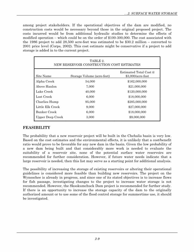
COST ESTIMATES
Cost estimates for the new reservoir projects are based on an assumed cost of $3,000 per acre-foot of storage, based on a review of construction costs for several recent dams. Actual costs of these recent projects varied widely, so the resulting estimates provided here are planning-level estimates only, based on limited information. Actual construction costs for reservoir construction depend on many factors that were not examined for this report. The cost estimates for each project are listed in Table 2.
Changing the proposed operational objectives of the Skookumchuck Dam or increasing the storage to the originally authorized amount would involve a detailed study to determine if it would be feasible, along with a public information campaign to develop a consensus
…2. SURFACE WATER STORAGE
2-9
among project stakeholders. If the operational objectives of the dam are modified, no construction costs would be necessary beyond those in the original proposed project. The costs incurred would be from additional hydraulic studies to determine the effects of modified operation – which could be on the order of $100-300,000. The cost associated with the 1986 project to add 28,500 acre-feet was estimated to be $30.2 million – converted to 2001 price level (Corps, 2002). This cost estimate might be conservative if a project to add storage is added in to the current project.
TABLE 2. NEW RESERVOIR CONSTRUCTION COST ESTIMATES
Site Name Storage Volume (acre-feet) Estimated Total Cost @
$3,000/acre-foot
Alpha Creek 54,000 $162,000,000
Above Hanlon 7,000 $21,000,000
Lake Creek 40,000 $120,000,000
Lost Creek 6,000 $18,000,000
Charlies Hump 95,000 $285,000,000
Little Elk Creek 9,000 $27,000,000
Bunker Creek 6,000 $18,000,000
Upper Deep Creek 3,000 $9,000,000
FEASIBILITY
The probability that a new reservoir project will be built in the Chehalis basin is very low. Based on the cost estimates and the environmental effects, it is unlikely that a cost/benefit ratio would prove to be favorable for any new dam in the basin. Given the low probability of a new dam being built and that considerably more work is needed to evaluate the suitability of a reservoir site, none of the potential surface water reservoirs are recommended for further consideration. However, if future water needs indicate that a large reservoir is needed, then this list may serve as a starting point for additional analysis.
The possibility of increasing the storage of existing reservoirs or altering their operational guidelines is considered more feasible than building new reservoirs. The project on the Wynoochee is already in progress, and since one of its stated objectives is to increase flows for fish passage, investigating changes to the project to increase water storage is not recommended. However, the Skookumchuck Dam project is recommended for further study. If there is an opportunity to increase the storage capacity of the dam to the originally authorized amount or to use some of the flood control storage for summertime use, it should be investigated.

3-1
3. WETLAND RESTORATION PROJECTS
GENERAL DESCRIPTION
This category of storage projects addresses ways to restore existing or historical wetland areas. Wetland restoration is also associated with projects discussed in Chapter 5, under “Block Agricultural Drainages” and “Beaver Reintroduction.”
Wetland restoration encompasses many types of projects, including increasing habitat diversity, riparian revegetation, and floodplain reconnection. The projects presented in this report would increase the volume of storage in a wetland, increase the wet area of a wetland, or increase the time that a wetland contains water. Such projects include reconnecting overbank areas to the floodplain, inundating historical wetland areas, and increasing the water depth in existing wetlands.
Wetland restoration is a vital part of a healthy biological and hydrological regime. While an individual project may contribute only a small amount of storage compared to a reservoir, wetlands provide many additional benefits including flood control, wildlife habitat, and water quality benefits.
Wetlands can be located in areas where groundwater is discharged to the surface or where the wetlands recharge groundwater. The selection of wetland restoration projects for this report assumed that expanding or restoring wet areas would recharge the groundwater in these areas and raise the groundwater table—particularly in the summer. A higher groundwater table helps maintain instream flows as groundwater is discharged into stream channels. Maintaining normal groundwater levels also is important when considering reservoir releases to maintain base flows. If groundwater levels are low, the supplemental flow from the reservoir discharge may be reduced as water seeps into the stream banks. If the water table is low enough, significant amounts of water may be lost to groundwater recharge. In addition, groundwater tends to be cool, sometimes significantly cooler than stored surface water in the summer. When discharged to streams, the cooler groundwater helps maintain stream temperatures within limits established by total maximum daily load (TMDL) studies. Both water quantity and water quality are highly dependant on maintaining adequate summer flows, which are dependant on groundwater.
POTENTIAL PROJECTS
The wetland projects described below were taken from Chehalis River at Centralia General Reevaluation Report/Environmental Impact Statement (Tetra Tech, 2001). Other sources examined for potential projects included Salmon and Steelhead Habitat Limiting Factors (WRIAs 22 and 23), Chehalis Basin Plan for Habitat Restoration (CBP, 2001), and Chehalis Basin Level 1 Assessment (Envirovision, 2000). Figure 3 shows the project locations.
It should be noted that the candidate wetland restoration projects are all located in the Centralia/Chehalis area because detailed wetland restoration project plans currently only exist for that area. Wetland restoration throughout the rest of the Chehalis watershed would also be beneficial, but specific plans for such projects have not yet been developed.

Chehalis Basin Water Storage Analysis…
3-2
Main Stem Scheuber Ditch Reconnection and Wetland Creation
This site is along the west side of the Chehalis/Centralia reach floodplain. The existing ditch collects runoff from several very small tributaries (including Coal Creek) and drains the adjacent farm fields. It joins the Chehalis River at approximately RM 71.5. The project area is approximately 75 acres, but could be substantially expanded to create wetland habitat if the real estate could be acquired.
Figure 3. Potential Wetland Restoration Projects
Restoration measures at this site, shown in Figure 4, include excavation of a channel connection to the SR-6 oxbow. The connection would allow flows to enter Scheuber Ditch from November to June. The ditch would be realigned to become a meandering side channel, possibly with riffle and pool sequences, or step weirs of large woody debris (LWD). A series of wetland areas would be excavated on both sides of the channel for a total of approximately 20 acres. Connections to tributary streams might need to be realigned to ensure fish passage. Blackberries and other invasive species would be removed and replaced with a 100-foot-wide riparian zone on each bank. This plan also includes the placement of LWD in the new channels and wetlands and in the oxbow.
Only a small percentage of flow is proposed to enter the side channel. A size-limited channel can be designed to achieve this goal; a bottom width of 8 to 10 feet would likely be appropriate. Additional measures may be taken to limit flow, including the placement of a flow-restricting culvert under SR-6. There should be no sedimentation problems in the newly excavated channel because sediment from the river would settle in the oxbow. The ditch outlet to the Chehalis River would have to be low enough in elevation to avoid erosion and headcutting from any drop and allow fish passage in both directions. It would be preferable to have the outlet enter the main stem on the inside of a meander bend or where

…3.. WETLAND RESTORATION PROJECTS
3-3
the river is relatively straight. Further hydraulic and sediment transport analyses would be necessary to design the channel geometry and profile.
Figure 4. Main Stem Scheuber Ditch Reconnection and Wetland Creation
South Fork Chehalis Revegetation and Wetland Creation, RM 0 to 5
Restoration measures at this site are shown in Figure 5. A large-scale riparian revegetation effort is proposed for this location, along with moderate wetland creation to promote groundwater recharge. Wetland creation would cover 10 total acres to be determined during the design phase. Banks would be sloped back to a 2:1 or flatter ratio in areas on the inside of meander bends or wherever feasible, and the floodplain would be excavated to allow seasonal inundation in some areas.

Chehalis Basin Water Storage Analysis…
3-4
Figure 5. South Fork Chehalis Revegetation and Wetland Creation, RM 0 - 5
A 50- to 100-foot-wide corridor would be revegetated with native riparian species and exotic species would be removed from that area. Where native trees already are present, they would be supplemented with underplantings of conifers and shrubs. Clumps of LWD would be keyed into banks where sloping actions are proposed to enhance stability and increase aquatic habitat diversity. Livestock fencing would be installed as needed. The bank sloping should be evaluated to ensure that it does not cause channel migration in developed areas. It appears that minimal channel migration occurs in this reach, but more detailed hydraulic and geotechnical analysis would be needed to evaluate the stability of the sloped banks and wetlands.

…3.. WETLAND RESTORATION PROJECTS
3-5
South Fork Chehalis Reconnections and Wetland Creation, South Fork and Main Stem Chehalis Confluence
This site is at the confluence of the South Fork and main stem Chehalis Rivers. A large fallow pasture exists between these rivers, bisected by SR-6 and a railroad. The proposed restoration measures at this site, shown in Figure 6, include excavating two 2-acre wetlands—one on the inside of the meander bend of the main stem, and one between the railroad and SR-6 on the left bank of the South Fork. The wetlands would increase channel diversity and off-channel habitat and elevate the groundwater table. They would be designed to prevent fish stranding.
Figure 6. South Fork Chehalis Reconnections and Wetland Creation, South Fork and Main Stem Chehalis Confluence
The riparian areas on the left bank of the main stem and between the main stem and the South Fork would be revegetated. Riparian zone widths would be a minimum of 100 feet.

Chehalis Basin Water Storage Analysis…
3-6
Non-native species would be removed and LWD placement would occur throughout the connection channels and wetlands.
Excavation of the site could lead to increased lateral migration of the channel. A large amount of fine material makes up the banks in this area, and erosion of the banks could occur. Excavating fairly narrow channels to the wetlands that would be inundated by winter flows would reduce the chance of either river migrating to the newly enhanced floodplain. A vegetated buffer of 50 to 100 feet and placement of LWD could stabilize the eroding banks and keep the migration rate lower.
Hydrologic, hydraulic, and sediment transport analyses should be conducted to determine design flows and channel geometry. The hydraulics under the bridges may be very complicated, which will require a detailed analysis and extensive coordination with the Washington State Department of Transportation and the railroad to ensure that there are no adverse effects on the bridges.
Newaukum Revegetation and Wetland Creation, at Chehalis Confluence
Restoration measures at this site, shown in Figure 7, would include creation of a 2-acre forested wetland and revegetation along the Chehalis and Newaukum Rivers upstream and downstream of their confluence. The forested wetland would be created by excavating the fallow pasture area 3 to 4 feet deep to receive inundation at a frequency of approximately 2-years. The floodplain should not be excavated lower than the elevation of the 1.5-year flow, in order to keep the main stem from migrating into the Newaukum and bridges.
For design purposes, additional information on previous meandering in this area would be helpful. Hydraulic analysis and sediment transport analysis will be necessary to determine whether realignment under bridges could cause failure. Further assessment of the stability of the outer bend of the river is required to determine what protection may be required other than vegetation.
Newaukum Reconnection and Wetland Creation, Stan Hedwall Park
At this site, the Newaukum River flows along the south side of Stan Hedwall Park, which has a low-lying, grassy area with no apparent use (other than for piping of wastewater to a sump). A park road elevated on a berm isolates this low-lying area from the river except during flood events (a culvert under the road appears to receive water during high flows, probably greater than the 5-year event). An island in the river at the upstream end of the park is dominated by willows and reed canary grass. Existing culverts in this area appear to be used to drain low-lying areas after flooding.
Restoration measures at this site, shown in Figure 8, include the conversion of the low-lying zone into a seasonally inundated wetland and revegetation of the upstream and downstream banks of the Newaukum. The park road would be notched and bridged to allow flow-through or be removed and reconstructed further north to allow wetland creation. Under either scenario, the existing berm would be left partly in place, but open channels would be excavated through the berm to connect the wetland to the river.

…3.. WETLAND RESTORATION PROJECTS
3-7
Figure 7. Newaukum Revegetation and Wetland Creation, at Chehalis Confluence
A 100-foot-wide riparian buffer would be established on both banks for approximately 1,200 linear feet. Clumps of LWD would be placed in the wetlands and Newaukum River to stabilize banks and increase aquatic and terrestrial habitat diversity. An existing old meander immediately upstream of the road would be excavated as needed to allow continuous connection during winter and spring (November through June), and additional riparian restoration would be done along both banks of the old channel, including the removal of non-native species.
More detailed surveys are required to determine the extent of excavation required for the channels and to reconnect the existing meander. A berm may have to be reconstructed farther back in the park to prevent flooding of the remainder of the park. Hydraulic analysis would be necessary to estimate lateral migration rates in the area to determine an appropriate inlet location to the wetland.
Chehalis Basin Water Storage Analysis…
3-8
Figure 8. Newaukum Reconnection and Wetland Creation, Stan Hedwall Park
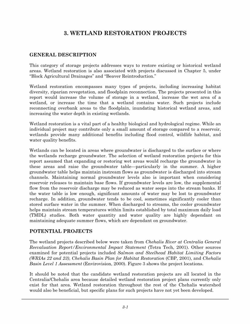
North Fork/South Fork Newaukum Confluence Connections and Wetland Creation
This 31-acre site is adjacent to the confluence of the Newaukum River North and South Forks. Restoration measures, shown in Figure 9, would include minor excavation of the floodplain to ensure annual inundation, placement of LWD in the channel of both forks and the main stem, and replanting riparian and floodplain vegetation in the floodplain area and a 50- to 100-foot-wide buffer along the North Fork. Vegetation and LWD would stabilize the stream channel and banks.

…3.. WETLAND RESTORATION PROJECTS
3-9
Figure 9. North Fork/South Fork Newaukum Confluence Connections and Wetland Creation
Salzer Creek Revegetation and Wetland Creation, Chehalis Confluence
Salzer Creek runs through a narrow ditch lined primarily with reed canary grass, with a few sparse, immature willows, alders and ash. An oxbow of the Chehalis River approximately 300 feet south of Salzer Creek at this site has year-round water. The oxbow is currently connected to the main stem during 2-year flow events via a low-lying swale (observed to be connected in winter 2001). The restoration area is 8 acres.
Restoration measures at this site, shown in Figure 10, include excavating an upstream and downstream channel at both ends of the oxbow, which would provide a connection to Salzer Creek during normal winter/spring flows (November through June).

Chehalis Basin Water Storage Analysis…
3-10
Figure 10. Salzer Creek Revegetation and Wetland Creation, Chehalis Confluence
Invasive vegetation would be removed, a 100-foot-wide riparian buffer would be established around the new channels and wetlands, and LWD would be placed in Salzer Creek, the main stem, and the oxbow. The buffer would extend from the main stem, around the wetlands and oxbow to Airport Road, and up Salzer Creek to Airport Road. Small upland areas could be incorporated into the wetland to increase terrestrial habitat diversity.
The area is relatively level and it may be possible to route the outlet channel from the oxbow through the wetland swale and into Salzer Creek further upstream of the mouth. More sinuosity in the oxbow channels could be designed to provide increased aquatic habitat. The oxbow lake should be evaluated to determine if groundwater is its source of constant water. If so, an outflow from the oxbow into Salzer Creek could provide continuous cooler water input to the system.
Additional hydrologic, hydraulic, and sediment transport analyses will have to be done for further design. A frequency analysis (or rainfall/runoff modeling if data are not available) needs to be conducted to evaluate the potential for adequate connections. An evaluation of sheer stress in the inlet channel should also be conducted.

…3.. WETLAND RESTORATION PROJECTS
3-11
Salzer Creek Reconnection and Wetland Creation, Frozen Foods Site
At RM 0.25 on Salzer Creek, just upstream of the railroad mainline crossing, the creek has been realigned in a series of 90° bends to run between two agricultural fields. The north side property (right bank) is used for disposal of frozen food liquid waste, which has been a cause of water quality problems. Salzer Creek has been realigned to the property boundary and is essentially in a ditch. The creek approaches the railroad bridge at a sharp angle and may be causing erosion at the bridge.
Restoration measures at this site, shown in Figure 11, include realignment of the creek through what appears to be the old meandering channel swale, excavation of the site to create a wetland and upland mosaic, placement of LWD in the channel and floodplain, removal of invasive vegetation, and revegetation of approximately 4 acres with wetland and riparian species. Although this would result in a slight shortening of the creek length, the proposed new alignment is more geomorphically stable and is likely the historical alignment. It would also eliminate a severe 90º turn occurring immediately upstream of the railroad bridge and reduce the need for future riprap or other bank protection.
Geomorphically, this project offers an excellent opportunity to restore a highly constrained portion of Salzer Creek. The new channel would be less subject to erosion and sediment deposition and would allow frequent flows into the floodplain. Elimination of the sharp turn upstream of the railroad bridge would lessen the likelihood of the structure being undermined in the future. However, hydraulic and sediment transport analyses should be conducted to determine the appropriate channel geometry. The upstream reaches of Salzer Creek should not be used as an analog to design the appropriate channel geometry since it is essentially a ditch.
Salzer Creek Revegetation and Wetland Creation, RM 3.1
This site is on Salzer Creek at RM 3.1, upstream of and immediately adjacent to Centralia-Alpha Road, which crosses the creek and floodplain. Approximately 600 to 800 feet upstream of the road crossing, Salzer Creek enters into seasonal wetlands where no defined channel exists. The floodplain receives overbank flows for a 2- to 5-year event.

Chehalis Basin Water Storage Analysis…
3-12
Figure 11. Salzer Creek Reconnection and Wetland Creation, Frozen Foods Site
Restoration measures at this site, shown in Figure 12, include excavation of a meandering low-flow channel through the wetland, excavation of wetland areas adjacent to the channel as needed for annual inundation, removal of reed canary grass and other invasive species, placement of LWD in the channel, and replanting approximately 28 acres with riparian and wetland species. Additional livestock fencing would be installed where needed.

…3.. WETLAND RESTORATION PROJECTS
3-13
Figure 12. Salzer Creek Revegetation and Wetland Creation, RM 3.1
Based on hydrologic/hydraulic modeling conducted for Lewis County, overbank flows occur at this site annually, and velocities are low (less than 3 feet per second) even during flood events (Tetra Tech 2001). The proposed concept of reconstructing wetlands and riparian buffers is appropriate from a geomorphic standpoint. These low energy areas on small tributaries serve an important function as sediment sinks and flood storage areas and can increase infiltration. The creation of wetlands will further enhance these functions as well as preventing incision of the channel, which often happens in meadow areas if grazing or

Chehalis Basin Water Storage Analysis…
3-14
other intensive land uses are present. The LWD will have to be anchored to keep it from floating downstream and blocking the culvert during high flows.
For design purposes, additional hydrologic, hydraulic, and sediment transport analyses will be necessary to develop the channel geometry for low flows to prevent erosion, determine the 1.5- and 100-year recurrence interval flows to ensure appropriate overbank connections, and define the limits of flooding to ensure that flooding of adjacent properties is not increased.
Salzer Creek Revegetation and Wetland Creation, RM 4.5
This site is between the Proffitt Road crossings on Salzer Creek at approximately RM 4.5. The project area is approximately 17 acres. Restoration measures, shown in Figure 13, include excavation of a meandering channel, excavation of a complex of wetland areas adjacent to the channel, removal of reed canary grass and other invasive species, placement of LWD in the channel, and replanting of a 100-foot wide riparian zone on each bank. The area would be fenced off from livestock as needed.
The gradient of the creek is slightly higher in this reach than downstream, but a riparian corridor is still appropriate from a geomorphic standpoint. Small pockets of floodplain wetland can be incorporated, but larger wetland areas may not be feasible due to the slope. Because of the higher gradient, surface flows would tend to drain, so creating a single continuous wetland would be difficult. Excavation of depressions for construction of wetland pockets may be necessary. The riparian corridor will add stability and reduce sediment loads as well as providing LWD. A more natural channel alignment is appropriate, as the channel currently appears to follow property lines. For design purposes, additional hydraulic and sediment transport analyses will be necessary to confirm sediment transport issues and drainage patterns and develop channel geometries and profiles.
WATER STORAGE ESTIMATE
Quantifying the amount of storage that would be available from wetland restoration projects is complex. An advanced study that would quantify the relationship between groundwater and surface water throughout the basin is needed in order to properly evaluate the water storage potential of projects that replenish surface water by recharging aquifers. Therefore, rather than quantifying the storage available for each project, the sites were compared based on the cost of producing an acre of wetland.
COST ESTIMATE
Table 3 summarizes the cost estimates for the proposed wetland projects. A detailed cost analysis for each project is contained in the General Reevaluation Report (GRR) Restoration Plan (Tetra Tech, 2002).

…3.. WETLAND RESTORATION PROJECTS
3-15
Figure 13. Salzer Creek Revegetation and Wetland Creation, RM 4.5
FEASIBILITY
All of the wetland projects presented here have been proposed as potential mitigation for the Centralia Flood Damage Reduction Project. At this point, all the projects are feasible if adequate funding is available. Of the projects listed here, the mitigation for the preferred plan recommended in the Centralia Flood Damage Reduction Project currently includes the Main Stem Scheuber Ditch wetland creation project.

Chehalis Basin Water Storage Analysis…
3-16
TABLE 3. COST ESTIMATES FOR RESTORATION ALTERNATIVES.
Site Construction
Cost
Total Project Area
(acres)
Wetlands Created (acres)
Cost per Acre of Wetland
Main Stem Scheuber Ditch $6,960,100 75 12 $580,000
SF Chehalis, RM 0-5 $11,912,000 57 <10 <1,200,000
SF Chehalis, Chehalis Confluence $1,363,400 13 8 $170,000
Newaukum, Chehalis Confluence $1,352,900 8 5 $270,00
Newaukum, Stan Hedwall Park $1,429,800 10 <1 >$1,430,000
NF/SF Newaukum Confluence $2,320,000 31 10 $232,000
Salzer Creek, Chehalis Confluence $324,000 8 <1 >$324,000
Salzer Creek, Frozen Foods Site $500,200 4 <1 >$500,000
Salzer Creek, RM 3.1 $1,445,400 28 <1 >$1,445,000
Salzer Creek, RM 4.5 $1,820,100 17 10 $182,000

4-1
4. AQUIFER STORAGE AND RECOVERY
GENERAL DESCRIPTION
Aquifer Storage and Recovery (ASR) is a process by which an aquifer is recharged with excess runoff or groundwater and is stored until it is needed at a later time. The recharge process typically occurs by means of an injection well. Infiltration ponds can also be used to recharge the aquifer if the topography and geology are suitable. In the Chehalis Basin, ASR would most likely use a well field for both the recharge and extraction of the water.
ASR has proven feasible in both confined and unconfined aquifers. However, in order for the ASR process to be successful, the aquifer must retain the stored water until it is needed and the water must remain free of contamination. The primary concern with unconfined aquifers is the potential for contamination from overlying land uses. While contaminants may penetrate the confining unit, or aquitard, of a confined aquifer, the risk is much less than within an unconfined aquifer (Landauer, 1998).
Compared to surface water storage projects, ASR has little impact on fish and wildlife habitat. The main impact on fish would likely occur at the point where the aquifer recharge water is originally diverted or withdrawn from its source (before injection). Because recharge withdrawals from streams or rivers would occur during wet winter months, the impact on instream flows would be minimal. Other environmental impacts may be caused by the well field and distribution infrastructure, but the infrastructure necessary for ASR generally is minimal.
POTENTIAL PROJECTS
According to the Chehalis River Watershed Surficial Aquifer Characterization (Ecology 1998), the Chehalis Basin’s principal surficial aquifers are contained in glacial and alluvial deposits in the river valleys and upland prairies. The surficial aquifers in the watershed typically begin a few feet below the ground surface and may extend to a depth of 100 feet. Bedrock units produce water locally, but well yields are generally low.
Although the surficial aquifers are generally tapped to provide for consumptive water use, they do not appear suitable for ASR, for the following reasons:
• Low depth to the water table would make the aquifer susceptible to contamination.
• High hydraulic connectivity with surface water makes retention of stored water difficult.
• Because the surficial aquifers in the basin are so shallow, injecting water into them may increase the risk of groundwater flooding.
Preliminary investigations into the watershed’s aquifers indicated that the most promising aquifer for ASR is the Newaukum Artesian aquifer. An artesian aquifer is a vertically confined aquifer whose water is under pressure. The Newaukum Artesian aquifer covers an area of approximately 25 square miles and lies within sedimentary rocks southeast of the

Chehalis Basin Water Storage Analysis…
4-2
City of Centralia (see Figure 14). At many places within this aquifer, well yields of several hundred gallons per minute are possible (Weigle and Foxworthy, 1962). Several factors, including the presence of a confining layer that would inhibit contamination, the well yields, and the aquifer’s proximity to major population areas (Napavine, Centralia, and Chehalis) make it a candidate for further study.
Figure 14. Newaukum Artesian Aquifer
Considerable additional study of the aquifer is needed before an ASR pilot project could be implemented. The characteristics of the aquifer would have to be evaluated in further detail, including the storage amount (specific storage) that the aquifer could hold and the rate at which water travels in the subsurface. These characteristics determine the rate at which water can be injected and recovered.
WATER STORAGE ESTIMATES
The potential for storage must ultimately be determined using groundwater modeling and field tests. The aquifer must be evaluated to determine its geologic and stratigraphic characteristics. The amount of water a confined aquifer can hold is defined by its “specific storage,” which is a function of fluid density, soil compressibility and soil porosity, and represents the effects of water expansion and aquifer consolidation due to a change in fluid pressure. The hydraulic conductivity of an aquifer defines the average rate at which water travels in the subsurface and depends on the permeability of the soil. Hydraulic conductivity defines the rate at which water can be stored or retrieved from an aquifer. If

…4. AQUIFER STORAGE AND RECOVERY
4-3
the hydraulic conductivity is too low, then water will not be able to be injected or retrieved at a rate high enough to justify the project. On the other hand, if the hydraulic conductivity is high and the aquifer is not laterally confined, the injected water may disperse too quickly and leave the area of extraction.
COST ESTIMATE
Costs for ASR are difficult to quantify at this preliminary stage. In addition to capital construction costs, an ASR evaluation should consider pre-project costs and post-project operation and maintenance costs. Pre-project costs, including initial project research, site evaluation, and pilot studies, can represent the majority of a project’s total cost (Landauer 1998). Capital costs could be reduced by retrofitting existing wells for recharge and extraction. Landauer (1998) describes the costing aspects of an ASR project as follows:
“Economic evaluation of water supply alternatives requires consideration of long term pre- and post-project costs as well as project capital costs. Initial project research, site evaluation, and pilot studies are considered long term pre-project costs. These pre-project costs are possibly the greatest for an ASR facility. Extensive investigation of the geology, stratigraphy and hydrogeology of a site is required to determine its acceptability for ASR. This investigation is likely to require numerous soil borings, well tests, and computer modeling. Post-project long-term costs lie primarily in maintenance and repairs plus general operation of the facility. For an ASR facility, maintenance of the dual-purpose wells is crucial in order to avoid irreparable damage to well equipment over time.
“The project capital costs are the costs accrued during the project’s initial construction. Depending on the individual ASR project, this cost can be minor in comparison to other costs or it can be large enough to govern the project. For ASR systems developed out of preexisting well fields, capital costs may only involve retrofitting wells for injection and installing the necessary piping for bringing water to the site for recharge. If the ASR facility is not constructed from a preexisting well field, then the capital cost will be much higher, reflecting the need to install wells and pumps, piping, and likely a water treatment facility.
“Though the economic costs of a water management project are the most tangible, external costs of the different alternatives must also be taken into consideration. External costs of water management alternatives are those costs that are not easily assigned a monetary value. Such external costs include effects on the environment, time spent gaining familiarity with regulations, and time spent educating and gaining the acceptance of the public.
“The environmental impact of a water project may occur in varying ways. Habitat disruption, loss of natural resources, and degradation of environmental aesthetics are all examples of the impact water projects are likely to inflict on the environment. Compared to constructing an above groundwater tank, ASR has minimal effects on the surrounding environment. Since water storage occurs below ground, animal habitat and the natural aesthetics are minimally affected. Natural resources may be compromised, however, if the ASR facility uses an unconfined

Chehalis Basin Water Storage Analysis…
4-4
aquifer. In this case, the extent of land development above the aquifer may often be limited.
“Time spent becoming familiar with the regulations and laws governing different water supply options is another external cost. Though the engineering techniques utilized in ASR are relatively elementary, legal concerns and regulatory guidelines are not yet fully established because of the method’s lack of historical application to water management problems. This may be a deciding factor in determining whether the cost of ASR outweighs the cost of more established means of managing water supply and demand.
“Finally, public education and acceptance of the project is an external cost to be considered. A project’s success requires support of the public, which in turn requires appropriate education about the technique. Again, the relative newness of ASR as a method of water management may make its acceptance as a legitimate, effective technique questionable in the eyes of the public. Education would likely be required not only for the public but also for other interested groups affected by the decision, such as regulators, engineers, and water planners. Though not as easily quantifiable as economic costs, the above mentioned externalities are costs which must be addressed when considering water management alternatives.”
Table 4 shows the costs of current ASR projects around the United States. Similar costs would be expected to implement an ASR project in the Chehalis Basin.
TABLE 4. CAPACITY AND COSTS OF ASR FACILITIES IN THE U.S.
Site
Water Recovered per Day (MGDa) Capital Costb
Cost per Water Recovered per Day ($/MGD)c
Kerrville, Texas 1.8 $987,000 $548,000
Centennial, Colorado 0.7 $410,000 $586,000
Seattle, Washington 5.1 $1,670,000 $327,000
Swimming River, New Jersey 1.7 $600,000 $353,000
Source: Landauer, 1998. a. MGD = million gallons per day b. Does not include operation and maintenance costs c. Capital cost divided by water recovered per day
The ASR project in Seattle was developed by Seattle Public Utilities and is located at the Highline Well Field. Other ASR projects in Washington, which are at different phases of study or completion, include the following:
• The Lakehaven Utility District—Lakehaven estimates the cost of its feasibility study for a project on the Mirror Lake aquifer to be $200,000, with $300,000 in additional studies required before the project will be fully realized. The project calls for 27 wells, each capable of pumping

…4. AQUIFER STORAGE AND RECOVERY
4-5
2000 gallons per minute. The estimated cost for each well is $1 to 2 million. (Bowman, 2003).
• The City of Yakima—The City estimates that the cost of a pilot test using existing wells was $350,000. Final costs are estimated to be $3 million per well (two wells are anticipated), with additional costs of around $300,000 for further testing and modeling (Brown, 2003).
• The Cities of Kennewick and Richland—This project is currently on hold, pending further investigation. No cost or volume estimates were available at the time of this report.
• The City of Redmond—An electronics firm is investigating the use of small-scale ASR to provide an emergency source of cooling water for its data storage facility. The status and costs of this project were not available for this report.
• The City of Walla Walla— The City has one functioning ASR well, and another well in the development phase. The City modified an existing well for recharge. The City estimates that the cost for one well was approximately $650,000. This cost does not include the on-going well monitoring that the City is handling. Each well is capable of recharging at a rate of 1250 gpm, and can withdraw at a rate of 2500 gpm. Recharge is on-going as long as there is excess water and that water meets water quality criteria (Krebf, 2003).
FEASIBILITY
In order to determine the feasibility of an ASR project in the Chehalis Basin, considerably more study will be required. The complex glacial geology in Western Washington makes site characterization for ASR extremely difficult and expensive. Long-term pumping records and extended monitoring activities are necessary to fully characterize aquifer systems in the region.
In addition to the general geology of the aquifer and its ability to store and produce water, other factors that affect the feasibility of an ASR project and that require further investigation include "microscale" characteristics. These include the mineralogical make-up of the aquifer soil, the chemical components of the native groundwater, and the microbial community in the aquifer. Each of these factors has the potential to affect the quality of native aquifer water and stored water (Landauer, 1998). The chemical make-up of the injected water can also be a limiting factor in ASR design. For example, injecting water treated with chlorine can result in the formation of disinfection byproducts that may pose serious water quality risks.

5-1
5. PROGRAMMATIC SOLUTIONS
GENERAL DESCRIPTION
The following projects are aimed at promoting basinwide infiltration to promote groundwater recharge, which would increase summer base flows:
• Provide forest conservation/restoration.
• Block agricultural drainages
• Support beaver populations
• Encourage low-impact development
Forest Conservation/Restoration
Historically, the majority of the land in the Chehalis Basin was forested. Over time, the Chehalis River system and the species that depend on it have developed an equilibrium based on the hydrologic cycle that exists at that level of forestation. As forests have been cleared and water has been diverted, the natural hydrology of the system has been impacted. Manifestation of these impacts include decreased evapotranspiration, increased runoff, and decreased infiltration to groundwater and base flow of streams. (USGS, 1998).
The relationship between vegetation and groundwater infiltration and storage is very complex. Variables that affect the process include season, climate, antecedent conditions, soil characteristics and vegetation type. Some research has been done to quantify the effects that forest removal has on infiltration rates and groundwater contribution in general; however, no study has been done in the Chehalis Basin. Most studies that have been done estimate the impacts of urbanization on surface water resources. One clear result from these studies is that surface water runoff increases significantly as forests are removed (Booth et al., 2002). The question that remains largely unanswered is how much of that increased runoff would have infiltrated and contributed to base flows.
Burges et al. (1997) have compared hydrologic behavior in forested and urbanized catchments in King County, Washington. The geologic conditions in the two catchments can be characterized as broad, till-capped plateaus, and although these conditions do not entirely match conditions in the Chehalis Basin, the results should generally apply. Their study indicated that subsurface flow dominated the hydrologic process in the forested area. With the removal of forest and urbanization, discharge from lawns and other pervious areas accounted for 60 percent of annual and storm runoff. While studies have indicated that forests increase evapotranspiration, they also have shown that precipitation is stored in the soil for longer periods in forested basins (Burges et al., 1997).
More study is needed to quantify the effects of forest harvesting and forest loss on basin hydrology; however, based on the historical conditions in the basin, it is clear that careful management of forest resources is critical to maintaining a viable hydrologic regime.

Chehalis Basin Water Storage Analysis…
5-2
Block Agricultural Drainages
Agricultural drainage is the removal of excess water from the soil surface or the soil profile of cropland by gravity or by artificial means. Drainages can either be surface, subsurface, or a combination of the two. Surface drainages generally consist of ditches that convey excess water away from the fields. Curved tiles or perforated pipes buried just below the ground surface are the most common techniques of subsurface drainage. As water infiltrates below the root zone of plants the tiles or pipes intercept the water and convey it off site. Clay or ceramic tiles are generally associated with older drainages before plastic pipe became easily accessible and are often still found on land that is no longer in agricultural production.
Improved drainage and agricultural production usually increase peak runoff rates, sediment losses, and pollutant loads on surface water resources. While agricultural drainage is necessary for economical and efficient crop production in many areas, it has had environmental costs. For example, it is estimated that more than half the original wetlands in the United States have been lost to drainage practices (Agricultural Drainage Bulletin 871-98). Much of this wetland loss is related to agricultural production in areas that were too wet to farm.
Loss of wetlands is associated with declines in wildlife habitat and adverse effects on water quality. The loss of wetlands and associated benefits to healthy ecosystem function have become an important environmental issue. Blocking, slowing down, or otherwise disabling the drainage tiles or networks used to drain agricultural areas can allow the area to return to a wetland state. The benefits of such a program include the following:
• Potential for habitat restoration
• Water quality improvement
• Potential for flood reduction
• Increased water storage and aquifer recharge.
Beaver Reintroduction
Beaver populations, which historically were common and abundant throughout the basin, have been severely reduced by trapping and hunting. Beavers are important regulators of aquatic and terrestrial ecosystems, with effects far beyond their food and space requirements. Beavers modify stream morphology and hydrology by cutting wood and building dams. This in turn influences a variety of biological responses within and adjacent to stream channels. Much of the following information has been drawn from the draft report Stream Habitat Restoration Guidelines (Saldi-Caromile et al., 2003) produced by several agencies within Washington State government including the Department of Fish and Wildlife.
The abundance of beavers drew early trappers and explorers to the Northwest. By 1900, continued exploitation left beavers almost extinct. Their removal resulted in incised channels, loss of riparian and wetland areas, and loss of channel complexity critical to fish and invertebrate production. Historically, beavers have been key agents of riparian succession and ecology throughout North America.

…5. PROGRAMMATIC SOLUTIONS
5-3
Further study into the possibility of beaver reestablishment is necessary, including an analysis of historical range and population size. Beavers are still present in the basin, as indicated by downed trees in several locations. It is possible that populations are currently reduced due to a lack of food.
Potential Benefits
According to Stream Habitat Restoration Guidelines (Saldi-Caromile et al., 2003), where beaver have been reintroduced the following benefits have been documented:
• Water tables have been elevated (which improves vegetation condition), water velocities, erosion and sedimentation reduced, fish habitat and water quality improved, water storage increased, and waterfowl nesting and brooding areas increased. The beavers’ effect is also important relative to population dynamics, food supply, and predation.
• Beaver dams on headwater streams can positively influence riparian function in many ways. They improve water quality by trapping sediments behind dams and by reducing stream velocity, thereby reducing bank erosion. Beavers can influence the flow regime of a watershed. Beaver ponds create a sponge-like effect by increasing the area where soil and water meet. Headwaters retain more water from spring runoff and major storm events, which is released more slowly, resulting in a higher water table and extended summer flows. This increase in water availability, both surface and subsurface, usually increases the width of the riparian zone and, consequently, favors wildlife communities that depend on that vegetation. Richness, diversity, and abundance of birds, fish, reptiles, and mammals can be increased by beaver activities.
• Beaver ponds are important waterfowl production areas and can also be used during migration. Beaver ponds provide very important salmon habitat in Western Washington. Juvenile coho and cutthroat are known to over-winter in beaver ponds and the loss of beaver pond habitat has resulted in the loss of salmon production potential.
• By starting in first-, second-, and sometimes third-order drainages, or below areas of erosion, beaver activity and stream sediment transport can re-elevate the bed level of incised channels, reactivate floodplains, increase stream bank water storage and aquifer recharge, and increase sediment deposition and storage.
• Once viable beaver complexes become established and are self-sustaining (three to four years), the complexes themselves begin to form natural gully plugs of a quarter- to half-mile in length, accelerating sediment deposition and riparian recovery further upstream. By facilitating the establishment of beaver dam complexes at intervals along a drainage or throughout a watershed, this process can create a leap frog effect, helping to accumulate or stabilize sediment in place throughout the system.
• Beavers can be used to initiate or accelerate the natural restoration of degraded or lost riparian systems. Identifying limiting factors and providing supplemental management techniques to compensate for these

Chehalis Basin Water Storage Analysis…
5-4
factors are important. With physical site conditions improved for initiation of natural riparian establishment, the system can develop to a self-sustaining level in as little as three to four years. By transplanting beavers to degraded sites, providing supplemental dam material during initial construction (to reduce dam washout prospects), and maximizing vegetative re-growth and establishment, riparian recovery and succession can be accelerated.
Potential Adverse Impacts
Beavers can disrupt the habitat of other wildlife species. Negative impacts include loss of spawning habitat, increase in summertime water temperatures beyond optimal levels for some fish species, loss of riparian habitat, barriers to migration for some fish species, and habitat conversion. Therefore, caution should be used in introducing beavers into areas where they were not endemic.
Beavers may become a nuisance if their activities conflict with other objectives for a stream. Common problems include cutting or eating desirable vegetation, flooding roads or irrigation ditches by plugging culverts, and increasing erosion by burrowing into the banks of streams or reservoirs. In addition, beavers carry Giardia pathogens, which can infect drinking water supplies and cause human health problems. In these areas, it is important to work in cooperation with adjacent landowners, transportation officials, and water purveyors.
Low-Impact Development (LID)
Extensive regional and national research shows a clear link between development in a watershed and degradation of aquatic resources. Conventional stormwater management practices have not always proven successful at fully mitigating for the effects of this development. Assuming a 1.5-percent annual growth rate, the population of the Chehalis Basin is expected to grow by 35 percent in the next 20 years. The accompanying development may have negative impacts on the basin’s water resources. One of the negative impacts will be increased runoff and reduced infiltration that accompany an increase in impervious surface.
In a pristine forest environment, stormwater is handled by a variety of mechanisms, including floodplain storage, channel storage, infiltration, interception, and small depression storage. These mechanisms attenuate peak flows and distribute stormwater uniformly throughout a basin. Low-impact development (LID) uses vegetation and small-scale hydrologic controls to capture, treat, store, and infiltrate runoff on-site, at the source. This helps to maintain a site’s and a watershed’s natural hydrology as development occurs. The LID approach contrasts sharply with the traditional approach of capturing, piping, and conveying stormwater away from the site. LID does not refer to growth management or density restrictions; rather, it emphasizes planning to minimize hydrologic impacts. LID practices such as reducing impervious surfaces, decreasing the use of storm drain piping and inlet structures, and eliminating or reducing the size of large stormwater management ponds can actually significantly reduce development costs. LID is a comprehensive design program that contains the following elements:
• Preservation of native vegetation, natural drainages and porous soils

…5. PROGRAMMATIC SOLUTIONS
5-5
• Reduction and disconnection of impervious surfaces
• The use of numerous, small-scale hydrologic controls throughout a site
• Clustering of development.
By mimicking the natural processes of a watershed, base flows may be enhanced as water is infiltrated and stored as groundwater. In addition, peak flows from stormwater runoff are lower, reducing the potential for flooding downstream of the development.
POTENTIAL PROJECTS
Forest Conservation/Restoration
Forests are important elements in preserving the hydrologic balance, as well as the ecological balance, of the basin. Forest products are also a large industry in the basin and forest practices should continue to be closely monitored and examined with respect to the impact they have on the basin’s hydrology. This has been an ongoing issue and is likely to remain one into the future.
The recommended project is twofold. First, a staff position would be created to serve as a “forest watershed steward.” This person would monitor forest practices activities throughout the Chehalis Watershed to provide a watershed-scale view of forestry activities. Part of the steward’s job would be to document successes and areas needing improvement in forest land management. The steward could also provide a liaison role between forest land managers and the Chehalis Basin Partnership.
The second component of recommended actions under Forest Conservation/Restoration is further research into the effects of decreased forest cover on infiltration, groundwater, and base flow in the basin. By quantifying the effects of deforestation and forest harvesting on base flows, new regulations can be fairly developed and administered or the proper mitigation can be specified.
Block Agricultural Drainage Tiles
There is little documentation of the amount of land being drained in the Chehalis Basin or the location of agricultural drainage networks. Recent estimates conclude that most of the drainage has historically been done in Lewis and Thurston Counties. Some drainage has occurred in Grays Harbor County, but according to Carl Boyd, the National Resource Conservation Service (NRCS) representative to Grays Harbor County, the amount is small and most of the acreage that has been drained has drainage systems that now are in disrepair and are not functioning (Boyd, 2003).
Ray Schuler, the NRCS representative to Lewis County, indicated that there may be approximately 2,000 acres of agricultural land in the county that have had drainage systems installed since the 1970s. There was no estimate of the amount of land served by drainage systems installed before 1970, but many of these older systems are in disrepair and no longer function. Most of the county’s cleared agricultural land in the Chehalis Valley has some sort of drainage system, but the systems are in varying degrees of repair. Most of
Chehalis Basin Water Storage Analysis…
5-6
that land is currently being farmed, so few drainage systems could be blocked (Schuler, 2003).
The NRCS no longer assists with the installation or upkeep of new or existing drainage systems. Due to stricter wetland regulations, it is unlikely that any new drainage systems will be installed. Permitting requirements also make it difficult for existing drainage systems to be maintained.
Removal of drainage tiles could be expensive, depending on the depth and extent of the networks. An alternative to removing all of the tiles would be to plug the outlet of the drainage system or disrupt the drainage by removing some tiles or blocking the drainage system at intervals. However, given the lack of information on the extent and condition of the drainage systems, the best course of action might be to establish a public information program that informs people of the effect that drainage systems have on water quality and runoff.
The recommended project includes the following elements:
• Establish a public information campaign that might consist of mailings and workshops focused on the effects of drainages and of the opportunities available.
• Establish a database and compile data of known drainage systems. Methods for identifying drainages include examining aerial photographs, examining NRCS records, and interviewing landowners. The database would serve as a means to track the extent of known drainage systems, their condition, and the current land use.
• Landowners could also be encouraged to voluntarily block existing drainages no longer needed or request assistance from their County in blocking drainages. Further investigation into the incentives, benefits, and funding sources available to landowners is also necessary.
Working with the agricultural interests in the basin will be important in developing a successful program, and the focus of the project does not have to be on removing or blocking drainages. Existing drainages could be modified to divert water to storage areas or the drainages could be blocked seasonally to store water or slow it down. A variety of solutions could be employed, depending on the specific characteristics of the drainage network. All of the solutions would depend on developing awareness among the drainage districts and working with them to develop compatible solutions. Any modifications to drainages would be made strictly with the agreement of the landowner. It is not anticipated that land currently in production would be affected.
Beaver Reintroduction
Beavers are often viewed as a nuisance species by landowners because of the impacts they have on streams. Often, current land use is not compatible with the effects beavers may have on land. As a result, efforts to import beaver into the area or to explicitly expand the beaver population could be highly contentious and are not recommended. However, many

…5. PROGRAMMATIC SOLUTIONS
5-7
people may not be aware of the important role beavers play in the ecosystem. Therefore, the recommended alternative contains the following elements:
• Emphasize the benefits of beavers in public information
• Encourage landowners not to automatically remove beavers when they are found in an area
• Establish a relocation program for nuisance beavers
Rather than endorse a program that would explicitly expand the existing beaver population. Efforts to restore riparian areas could include elements that would support beaver. By ensuring an adequate food supply with willow stakes and coniferous plantings, the beaver population should naturally expand to fill habitat over time. This would essentially be restoring a creek or stream to its natural condition—a condition that has historically served as habitat for beavers and other animal populations. The ultimate consequence of this restoration would be hydrologic improvements that would promote instream flows.
Low-Impact Development
Since the Chehalis Basin is primarily forest covered and development densities tend to be low outside of the basin’s cities, a policy of LID could be implemented to reduce the impact from future development in the basin.
LID policies could be adopted as part of the construction permitting process in the basin. Adopting a low-impact development program would require the cooperation of all or most of the municipal jurisdictions in the basin. Currently, Thurston County has a policy of LID in its stormwater regulations, however, the other Counties do not. A model ordinance should also be developed that could be modified or directly adopted by municipalities. In addition, the cost benefits of LID should be documented and made available to the public as well as to developers. Given its broad participation, the Chehalis Basin Partnership would be a good forum to develop the coordination needed to initiate an LID program.
A method that could be used in existing developments is to minimize the amount of impervious surface that is directly connected to the storm drain network—referred to as the effective impervious area. One simple and inexpensive method to reduce effective impervious area is to disconnect downspouts that are connected to the drainage collection system and redirect them to pervious areas where the runoff can infiltrate. This could be done by individual property owners if they are made aware of the benefits and are instructed how to do it without concentrating flow and instigating new problems. A public information program should include the effects of impervious area and how individuals may mitigate some of these effects.
WATER STORAGE ESTIMATE
Quantifying the amount of storage that would be made available by programmatic projects is complex. The relationship between infiltration, groundwater storage and surface water base flows has not been quantified within the Chehalis Basin. A detailed study that would

Chehalis Basin Water Storage Analysis…
5-8
quantify this relationship is needed to properly evaluate the water storage potential of programmatic projects. This would largely be an academic exercise and opportunities to endorse or fund a project should be investigated.
COST ESTIMATE
Table 5 summarizes estimated costs for the programmatic solutions. The costs listed are for the recommended projects and are based on a 5-year time line. These costs include public information and policy activities, but do not include costs for specific on-the-ground projects that might be developed. For example, no costs are estimated for blocking any specific agricultural drainages. Some planning level cost estimates have been developed previously for on-the-ground projects, for example, in the GRR Restoration Plan (Tetra Tech, 2002) the cost for removing drain tiles from 1,000 acres was estimated to be $11,200,000. A large-scale forest restoration project over the entire basin would likely cost more than $10,000,000.
TABLE 5. ESTIMATED COST OF PROGRAMMATIC PROJECTS
Project Estimated Cost
Block Agricultural Drainages $207,000
Low-Impact Development $120,000
Beaver Reintroduction $170,000
Forest Conservation/Restoration $300,000

6-1
6. NON-STORAGE PROJECTS
Projects or programs that do not involve water storage but could be implemented to help maintain minimum instream flows are discussed briefly below.
WASHINGTON WATER ACQUISITION PROGRAM
According to the Department of Ecology, the Chehalis Basin is not currently involved in this program. It is a voluntary program to increase stream flows in watersheds with vulnerable salmon and trout populations. Program participants are holders of water rights who sell or lease to the state all or part of their water right or donate all or part of the water right on a permanent or temporary basis.
WATER RIGHTS TRADES OR LOANS
This voluntary program would be similar to the Water Acquisition Program, but instead of water rights being sold or leased to the state, they would be traded or leased to other private entities. This could have the effect of meeting water demand in areas that lack further water rights without any increase in overall water rights in the basin.
IRRIGATION EFFICIENCY
Increasing agricultural irrigation efficiency could reduce the amount of withdrawal from surface water and groundwater sources, leading to higher instream flows. Participants in the state Water Irrigation Efficiencies Program may voluntarily place all or part of water saved into a trust to enhance stream flows. Grants administered by local conservation districts are available to assist with increasing efficiency, based on demonstrated need and environmental benefit. The proportion of saved water placed in the trust must be at least equal to the percentage of public investment in the irrigation efficiency.
WATER CONSERVATION
Increased water conservation reduces the amount of water being withdrawn from surface water and groundwater sources, leading to higher instream flows. Adjusting water rate structures can promote conservation by charging more for water usage above a specified volume. Such a rate structure would be designed to encourage larger water consumers to use water more efficiently.
RECYCLED WASTEWATER
Recycled wastewater (gray water) can be used in lieu of other water withdrawals for the irrigation of agricultural or landscaped areas. The City of Chehalis is currently designing a regional wastewater treatment plant that incorporates recycled wastewater. The plant is expected to be on line before 2008. The recycled water will be used to irrigate a poplar plantation. This project could be used as a model for future treatment plants.


7-1
7. EVALUATION AND RECOMMENDATIONS
EVALUATION OF POTENTIAL PROJECTS
Projects examined for water storage were divided into high-yield and low-yield categories. This classification was used to emphasize which projects have the potential to provide significant quantities of stored water, without diminishing the importance of projects that won’t provide large quantities of stored water but are very beneficial to the overall health of the watershed. Evaluation of projects in each category is discussed below.
High-Yield Project Evaluation
The high-yield category encompasses projects that are projected to supply a significant amount of water, an amount that might be suitable for the water supply of a small city, for example. The projects in the high-yield category are listed in Table 6, along with their estimated costs and water storage volumes. These projects emphasize water storage, and storage volumes are more easily estimated.
TABLE 6. SUMMARY OF HIGH-YIELD PROJECTS
Project Name Type of Project Storage Volume Estimate
(acre-feet) Estimated Cost
Charlies Hump New Reservoir 95,000 $285,000,000
Alpha Creek New Reservoir 54,000 $162,000,000
Lake Creek New Reservoir 40,000 $120,000,000
Little Elk Creek New Reservoir 9,000 $27,000,000
Skookumchuck Dam Existing Reservoir 8,500 $30,000,000a
Above Hanlon New Reservoir 7,000 $21,000,000
Lost Creek New Reservoir 6,000 $18,000,000
Bunker Creek New Reservoir 6,000 $18,000,000
Upper Deep Creek New Reservoir 3,000 $9,000,000
Newaukum Aquifer ASR Unknown $2 - 5,000,000
a. Skookumchuck Dam cost was estimated in 1986 as a stand-alone project, costs might be lower if it was added to the current project.
Projects in the high-yield category were scored on the following criteria:
• Cost
• Water storage potential
• Recreation potential
• Environmental impacts/benefits

Chehalis Basin Water Storage Analysis…
7-2
• Location (proximity to water needs).
A score between 0 and 10 was given for each criterion except for environmental impacts/benefits, for which the range of possible scores was -10 to 10. High scores were given where available information indicated a more favorable rating relative to the other projects evaluated. For example, a lower cost project was given a higher score than a more expensive project. Since the quality of information varies considerably among criteria and projects, the ratings rely on professional judgment. Table 7 summarizes the project scoring.
TABLE 7. SCORING OF HIGH-YIELD PROJECTS
Scoringa
Project Name Project
Category Cost
Water Storage
Potential Recreation Potential
Environmental Impacts/ Benefits Location Total
Newaukum Aquifer
ASR 9 8 0 0 9 26
Skookumchuck Dam
Existing Reservoir
8 8 3 -2 7 24
Alpha Creek New Reservoir
2 8 5 -3 8 20
Above Hanlon New Reservoir
3 7 6 -4 7 19
Little Elk Creek
New Reservoir
3 7 6 -4 7 19
Charlies Hump
New Reservoir
1 9 6 -6 7 17
Upper Deep Creek
New Reservoir
4 5 5 -4 7 17
Lake Creek New Reservoir
2 8 6 -8 7 15
Lost Creek New Reservoir
3 7 6 -8 7 15
Bunker Creek New Reservoir
3 7 6 -8 7 15
a. A score between 0 and 10 was given for each criterion except for environmental impacts/benefits, for which the range of possible scores was -10 to 10. Higher scores indicate a more favorable rating. For environmental impacts/benefits, a negative score was given if a project would have a detrimental environmental impact and a positive score was given to projects having a beneficial impact.
Scores for recreation potential and environmental impacts/benefits, which could not be quantitatively evaluated, were assigned based on conventional wisdom and previous

…7. EVALUATION RECOMMENDATIONS
7-3
experience. For environmental impacts/benefits, a negative score was given if a project would have a detrimental environmental impact and a positive score was given to projects having a beneficial impact.
Based on the evaluation, the Skookumchuck Dam modifications and an investigation into ASR in the Newaukum Artesian Aquifer are recommended for further analysis. The new reservoir projects have obvious and quantifiable water storage merits, but are not recommended because of their potentially high cost and environmental impacts. In addition, the information used to identify the new reservoir projects is not sufficient to evaluate the feasibility of the projects. If the Partnership identifies a clear need for new surface water reservoirs in the future, this list of potential projects is a good starting point for a more rigorous evaluation.
It should also be noted that another viable mechanism to obtain large quantities of water is through the non-storage projects discussed in Chapter 6. In particular, acquiring valid water rights may be the most economical and fastest way to obtain additional water for in-stream and out-of-stream uses. In a recent local example, the City of Napavine is in the process of purchasing an existing water right at a cost of approximately $200,000 for 100 acre-feet per year.
Low-Yield Project Evaluation
The low-yield category encompasses projects that are not projected to supply a large amount individually, but for which the water storage effects may become significant as multiple projects are completed. One element that should be included with all of the low-yield projects is a study that examines the project’s impact on existing land uses, environmental benefits, increased potential for flooding, effect on water quality, and amount of water stored. In general, this can only be developed once a specific project has been proposed and is being analyzed.
Comparing and ranking these projects is difficult because their water storage benefits are difficult to quantify without a clearer understanding of the relationship between groundwater and surface water in the basin. In addition, with the exception of the specific wetland restoration projects, the environmental impacts/benefits, location, and recreation potential are not known because they vary with specific projects. Because the programmatic projects proposed here are relatively inexpensive, and wetland restoration in general is a highly recommended policy, all of the programmatic projects are recommended, along with a general recommendation for wetland restoration.
A very detailed evaluation of the wetland projects presented in this report was completed as part of the Chehalis River at Centralia General Reevaluation Report/Environmental Impact Statement and is included in the Restoration Plan (Tetra Tech, 2001). Table 8 summarizes the estimated cost and benefits (expressed in habitat units) that a particular project would provide. Since wetland projects do not necessarily emphasize water storage, the intent of this table is to illustrate both the water storage benefit (wetlands created) and other environmental benefits (habitat units) that a project may provide.
A habitat unit is representative of the benefit provided by a given project and includes effects on watershed-level processes and effects on localized habitat quality. A project that

Chehalis Basin Water Storage Analysis…
7-4
has more habitat units will have a larger beneficial environmental impact. A more complete description of the methodology used to develop the habitat units for each project is included in the Restoration Plan (Tetra Tech, 2003).
TABLE 8. SUMMARY OF WETLAND PROJECTS
Site Project Cost
Total Project Area
(acres)
Wetlands Created (acres)
Output (habitat units)
Main Stem Scheuber Ditch $6,960,100 75 12 662
SF Chehalis, RM 0-5 $11,912,000 57 <10 161
SF Chehalis, Chehalis Confluence $1,363,400 13 8 128
Newaukum, Chehalis Confluence $1,352,900 8 5 346
Newaukum, Stan Hedwall Park $1,429,800 10 <1 483
NF/SF Newaukum Confluence $2,320,000 31 10 349
Salzer Creek, Chehalis Confluence $324,000 8 <1 101
Salzer Creek, Frozen Foods Site $500,200 4 <1 71
Salzer Creek, RM 3.1 $1,445,400 28 <1 79
Salzer Creek, RM 4.5 $1,820,100 17 10 76
Table 9, shows a rough cost/benefit comparison for each wetland project. The cost per acre of wetland gives a rough estimate of the potential for increased groundwater infiltration; the cost per habitat unit gives a rough estimate of the general benefits a project might provide relative to its costs.
TABLE 9. COST/BENEFIT
Project Name Cost per Acre
of Wetland Cost Per
Habitat Unit
Main Stem Scheuber Ditch $580,000 11,000
SF Chehalis, RM 0-5 <1,200,000 74,000
SF Chehalis, Chehalis Confluence $170,000 11,000
Newaukum, Chehalis Confluence $270,00 4,000
Newaukum, Stan Hedwall Park >$1,430,000 3,000
NF/SF Newaukum Confluence $232,000 7,000
Salzer Creek, Chehalis Confluence >$324,000 3,000
Salzer Creek, Frozen Foods Site >$500,000 7,000
Salzer Creek, RM 3.1 >$1,445,000 18,000
Salzer Creek, RM 4.5 $182,000 24,000

…7. EVALUATION RECOMMENDATIONS
7-5
RECOMMENDATIONS
The projects and programs recommended for further investigation or implementation are summarized below. All of these projects will require additional detailed feasibility assessment if pursued. Of particular concern at this time is the connection of surface water and the propagation of mosquitoes that transmit the West Nile virus.
Aquifer Storage and Recovery
Preliminary investigations into the watershed’s aquifers indicated that the most promising aquifer for ASR is the Newaukum Artesian Aquifer. The Newaukum Artesian Aquifer covers an area of approximately 25 square miles and lies within sedimentary rocks southeast of the City of Centralia. At many places within this aquifer, well yields of several hundred gallons per minute are possible (Weigle and Foxworthy, 1962). Several factors, including the presence of a confining layer that would inhibit contamination, the well yields, and the aquifer’s proximity to major population areas (Napavine, Centralia, and Chehalis) make it a candidate for further study.
Considerable additional study of the aquifer is needed before an ASR pilot project could be implemented. The characteristics of the aquifer would have to be evaluated in further detail, including the specific storage that the aquifer can hold and the hydraulic conductivity. Test wells would have to be drilled and groundwater modeling of the aquifer would be necessary before a pilot project could be established. While considerably more data must be collected before an accurate cost estimate can be generated, the cost of this project is expected to be in the range of several million dollars.
Skookumchuck Dam Modifications
The Army Corps of Engineers has identified a project for flood control improvements for the Skookumchuck Dam. The plan will involve setback of levees on the Chehalis and Skookumchuck Rivers, combined with modification of the Skookumchuck dam for an additional 20,000 acre-feet of flood storage.
The recommended plan is to further investigate the possibility of expanding the storage of the Skookumchuck reservoir to the originally authorized volume of 28,500 acre-feet. The project volume was reduced to 20,000 acre-feet after it was determined that no additional flood control benefits would be achieved for a volume greater than 20,000 acre-feet. If, however, some of that volume could be used for water storage, it may be worth expanding the reservoir by the larger amount.
If only the additional 20,000 acre-feet of storage is created, negotiations with the FERC should emphasize the need for low-flow augmentation as part of operation of the dam. If the full 20,000 acre-feet was available, it could be used to release up to 110 cfs from August through October. Additional studies would have to be conducted to work out the details of such a plan. For example, the dates at which the dam would begin storing water would have to be chosen carefully so as not to undermine the flood control aspect of the dam.

Chehalis Basin Water Storage Analysis…
7-6
Wynoochee Dam Modifications
The City of Tacoma and the U.S. Army Corps of Engineers have an active project on the Wynoochee Dam. The proposed modifications would significantly reduce fish losses and increase summer streamflows in the Wynoochee River. It is the recommendation of this multipurpose water storage study that the Chehalis Basin Partnership monitor implementation of the Wynoochee Dam project to ensure that the Wynoochee Dam project contributes to the goals and objectives of the Watershed Management Plan currently being developed by the Chehalis Basin Partnership.
Beaver Reintroduction
The recommended alternative is to establish a public information program that will explain the beneficial effects that beavers have on ecosystems and encourage landowners not to automatically remove beavers from an area. Establishing a program to relocate nuisance beavers is also a recommended priority. It is not recommended at this time to set up a program to actively reintroduce beavers to areas in the basin.
As with the other recommended programmatic solutions, this program is a long-term solution that would not provide immediate or quantifiable results. It is based on the premise that if portions of the watershed can be restored to their natural condition—a condition that has historically served as habitat for beavers and other animal populations—then ultimately the consequence of this restoration would be a more natural hydrologic regime that would promote instream flows. The estimated 5-year cost of this project is $170,000.
As with other projects that focus on improving base flow through groundwater recharge, an additional study should be commissioned to quantify the relationship between infiltration, groundwater, and surface water.
Forest Conservation
Since historical records indicate that the vast majority of the basin was originally forested, a continuing emphasis on forest conservation is recommended. An advanced study is needed to quantify the relationship between forest cover, infiltration, groundwater, and surface water. By quantifying the effects of forest harvesting on base flows, new regulations can be fairly developed and administered or proper mitigation can be specified.
Agricultural Drainage Removal
The recommendation is to establish a public information program that will be instructive of the effects that agricultural drainages have on wetlands, water quality, and runoff. As part of this program, a database would be established to help track existing drainage systems, their condition, and the current land use. There is very little existing data on the location and extent of agricultural drainages; therefore most of the data will have to be collected from existing NRCS records and/or the personal knowledge of landowners and farmers.
Landowners would also be encouraged to voluntarily block existing drainages no longer needed or request assistance from their county in blocking drainages. Since a variety of

…7. EVALUATION RECOMMENDATIONS
7-7
solutions could be employed depending on the specific characteristics of the drainage network, assistance could be made available to landowners interested in blocking or modifying their drainages.
As with the other recommended programmatic solutions, this alternative is a long-term solution that does not provide immediate or quantifiable results. The estimated 5-year cost of this project is $207,000, which does not include the cost of any project assistance that may be necessary.
Low-Impact Development
Since the Chehalis Basin is primarily forest-covered and development densities are low outside the basin’s cities, LID could be emphasized to reduce the impact of future development in the basin. In existing developments, steps can be taken to minimize the amount of impervious surface that is directly connected to the storm drain network.
The recommended project is a public information program that would include information on the effects of impervious area, explain how individuals can mitigate these effects, and indicate how development costs might be reduced by implementing LID. The program could also include information on the benefits of a policy of LID for new development in the basin. In addition, a model ordinance could be developed that could be easily adopted or modified by the counties within the basin.
Although the benefit of this project is not likely to be felt in the near future, it is recommended because it is an inexpensive way to prevent future problems that could arise with development in the basin. The estimated 5-year cost of this project is $120,000.
Wetland Restoration
Although wetland restoration is a vital part of a healthy biological and hydrological regime, no specific wetland project is recommended, primarily because of the high cost of a wetland relative to its water storage potential. However, a general program of wetland restoration is strongly recommended. If money becomes available for wetland projects as mitigation in the basin, restoration projects that expand wet areas or reconnect the floodplain should be given additional weight. Further investigation is needed to quantify the general effects that wetlands and infiltration programs have on surface water quantities. It should also be reemphasized that many other wetland projects may exist in the basin. The projects listed in this report are based on a survey of existing information that has been focused in a relatively small portion of the basin.
SUMMARY
This survey of multipurpose storage opportunities provides information that can be used for numerous purposes:
• If an entity is looking for a project with potential to provide a large quantity of water for in-stream or out-of-stream use, the discussion, ratings and cost estimates for high-yield projects will provide the most useful information.
Chehalis Basin Water Storage Analysis…
7-8
• For entities primarily concerned with baseflow restoration, all projects that encourage infiltration of rainwater will be beneficial. In addition, all projects in the low-yield classification provide substantial ecological benefits that go beyond baseflow restoration. For that reason, these projects could be implemented for other reasons, such as habitat restoration, water quality improvement, and as mitigation for other projects with environmental impact. High-yield projects, especially aquifer storage and recovery, could also be pursued for baseflow augmentation purposes.
• Most of the recommended projects contained in this report have a strong emphasis on public information. Water is consumed by everyone in the basin for a variety of uses, and most of the limiting factors stem from current land use practices and attitudes toward water consumption. Residents often do not know that simple changes in how drainage and water use is perceived can have positive impacts on water supply and instream flows. Given the increasing difficulty in developing new water supply projects, the most logical place to begin is to make people aware that a problem with instream flows exist and to explain how the hydrology of the basin works. People can then more easily make the connection between how traditional views of consumption and drainage may impact the basin’s hydrology, and they may be more open to adopting solutions for the future.

R-1
REFERENCES
Booth, D.B., D. Hartley, and R. Jackson. 2002. Forest Cover, Impervious-Surface Area, and the Mitigation of Stormwater Impacts. Journal of the American Water Resources Association. 38(3):835-845.
Bowman, J. 3 May 2003. Personal Communication (telephone conversation with Tom Spangenberg, Tetra Tech/KCM, Inc., Seattle, WA). The Lakehaven Utility District, Federal Way, WA.
Boyd, C. 12 May 2003. Personal Communication (telephone conversation with Tom Spangenberg, Tetra Tech/KCM, Inc., Seattle, WA). National Resource Conservation Service.
Brown, D. 21 May 2003. Personal Communication (telephone conversation with Tom Spangenberg, Tetra Tech/KCM, Inc., Seattle, WA). The City of Yakima, Yakima, WA.
Burges, S.J., M.S. Wigmosta, and J.M. Meena. 1998. Hydrological Effects of Land-Use Change in a Zero-Order Catchment. Journal of Hydrologic Engineering. 86-97.
Chehalis Basin Partnership. 2001. Chehalis Basin Plan for Habitat Restoration. 2-168 pp.
Hansen, W.J., K.D. Orth, R.K. Robinson. 1998. Cost Effectiveness and Incremental Cost Analyses: Alternative to Benefit-Cost Analysis for Environmental Remediation Projects. Practice Periodical of Hazardous, Toxic, and Radioactive Waste Management. 8-12.
Hirschey, S.J., and K.A. Sinclair. 1992. A Hydrogeologic Investigation of the Scatter Creek/Black River Area, Southern Thurston County, Washington State. Masters Thesis. The Evergreen State College, Olympia, WA.
Krebf, T. 17 June 2003. Personal Communication (telephone conversation with Tom Spangenberg, Tetra Tech/KCM, Inc., Seattle, WA). City of Walla Walla, Walla Walla, WA.
Landauer, L.J. 1998. Aquifer Storage and Recovery and its Application to Aquifer Systems Typical of the Puget Sound Region. Masters Thesis. University of Washington, Seattle, WA.
Mahlum, S.E. 1976. Water Resources Management Program: Chehalis River Basin. DOE Basin Program Series, No. 2. Second Edition. State of Washington Department of Ecology, Water Resources Management Division, Olympia, WA.
McChesney, D. 2001. 2001 Report to the Legislature: Artificial Storage and Recovery of Ground Water. Progress Report. DOE Publication Number 01-11-019. Washington State Department of Ecology, Water Resources Program, Olympia, WA.

R-2
Natural Resources Consultants, Inc. 1994. An Inventory of Off-Channel Habitat of the Lower Chehalis River with Applications of Remote Sensing. Prepared for The Quinault Indian Nation and the U.S. Fish and Wildlife Service. Natural Resources Consultants, Inc., Seattle, WA.
Saldi-Caromile, K., K. Bates., P. Skidmore, J. Barenti, D. Pineo. 2003. DRAFT Stream Habitat Restoration Guidelines. Co-published by the Washington departments of Fish and Wildlife, Ecology, and Transportation, U.S. Fish and Wildlife Service, and U.S. Army Corps of Engineers. Olympia, Washington.
Schuler, R. 12 May 2003. Personal Communication (telephone conversation with Tom Spangenberg, Tetra Tech/KCM, Inc., Seattle, WA). National Resource Conservation Service, Olympia, WA.
Sexaur, B. 5 June 2003. Personal Communication (telephone conversation with Tom Spangenberg, Tetra Tech/KCM, Inc., Seattle, WA). Corps of Engineers, Seattle, WA.
Sinclair, K.A., and C.F. Pitz. 1999. Estimated Baseflow Characteristics of Selected Washington Rivers and Streams. Water Supply Bulletin No. 60. DOE Publication Number 99-327. Washington State Department of Ecology, Environmental Assessment Program, Olympia, WA.
Smith, C.J., and M. Wenger. 2001. Salmon and Steelhead Habitat Limiting Factors: Chehalis Basin and Nearby Drainages Water Resource Inventory Areas 22 and 23. Washington State Conservation Commission, Olympia, WA.
Tetra Tech, Inc., Infrastructure Services Group. 2001. Chehalis River at Centralia General Reevaluation Report/Environmental Impact Statement. Draft Restoration Plan. Tetra Tech, Inc., Infrastructure Services Group, Seattle, WA.
U.S. Department of Agriculture. 1974. Southwestern Washington River Basins: Type IV Survey. USDA Soil Conservation Service, Economic Research Service, Forest Service, State of Washington, Olympia, WA. 99-137 pp.
U.S. Department of Agriculture. 1974. Southwestern Washington River Basins: Type IV Survey. USDA Soil Conservation Service, Economic Research Service, Forest Service, State of Washington, Olympia, WA. 149-197 pp.
Weigle, J.M., and B.L. Foxworthy. 1962. Geology and Ground-Water Resources of West-Central Lewis County, Washington. Water Supply Bulletin No. 17. State of Washington Department of Conservation, Division of Water Resources, Olympia, WA.
Winter, T.C., and J.W. Harvey, O.L. Franke, and W.M. Alley. 1998. Ground Water and Surface Water: A Single Resource. U.S. Geological Survey Circular 1139. Denver, CO.