Characterizing the Spectral Trajectory of Cerrado Regeneration...
13
Characterizing the Spectral Trajectory of Cerrado Regeneration to Estimate Its Age Priscilla S. Costa-Pereira 1 and Philippe Maillard 1 1 Universidade Federal de Minas Gerais – UFMG, Av. Antônio Carlos, 6627, Belo Horizonte - MG, Brazil, [email protected]om.br , [email protected] ABSTRACT Cerrado is a woody savanna formation found in Brazil with a very complex structure and rich biodiversity suffering increased human pressure. Medium to fine resolution remote sensing data are the only means to monitor the evolution of its conversion and regeneration. With this study our objectives were to: understand how and at what speed cerrado regenerates after a clear cut; determine what spectral variables best represent its age and establish clearly what contribution multitemporal optical remote sensing can bring to estimate the age of cerrado regeneration. Our reference data is composed of 47 plots that were surveyed in a state park in Minas Gerais that used to be an eucalyptus plantation until 1994 and for which the exact age of regeneration is precisely known. Eighteen Landsat TM images were digitally processed to model the reflectance trajectory of the regenerating cerrado. Results show that whereas structural measurements can be used to estimate the age of regeneration for the first few years, the spectral counterpart shows potential for estimating the age of a more advanced regeneration stage. In particular, the spectral trajectory of band 5 shows a quase-linear trend that directly relates to the time elapsed after the clear cut. Keywords: Cerrado, Regeneration, Reflectance 1 INTRODUCTION Cerrado is a woody savanna vegetation that occupies an area of over 2 millions km², representing 22% of the Brazilian territory. Cerrado vegetation is rich in biodiversity, as much in abundance as in variability of species. The flora of Cerrado has over 10.000 plant species, where 4.400 are endemic, representing 1,5% of all plants in the world. It is habitat for a total of 1.268 species of vertebrates, where 117 are endemic (Myers et. al, 2000). Biodiversity of the Cerrado is linked to his physiognomic variations, ranging from grassland to wooded savanna and forest, forming a gradient of height and tree density. Grassland is characterized by the absence of trees, with only a few bushes and a predominance of grasses. In wooded savannas, trees and shrubs are also present in varying density. The forest physiognomies are characterized by the predominance of arboreal species and the formation of a closed canopy. The literature about Cerrado vegetation is extensive and there are several classifications of its physiognomies. A general classification, based on the density of woody individuals, recognizes five structural types of Cerrado vegetation (Figure 1): campo limpo (open grassland), campo sujo (open shrubby savanna), campo cerrado (open woody savanna), cerrado sensu-stricto (woody savanna) e cerradão (savanna woodland) (Goodland, 1971; Coutinho, 1978). Figure 1. Cerrado’s physiognomies (Mistry, 1998).
Transcript of Characterizing the Spectral Trajectory of Cerrado Regeneration...

Characterizing the Spectral Trajectory of Cerrado Regeneration to Estimate Its Age
Priscilla S. Costa-Pereira1 and Philippe Maillard1
1 Universidade Federal de Minas Gerais – UFMG, Av. Antônio Carlos, 6627, Belo Horizonte - MG, Brazil, [email protected] , [email protected]
ABSTRACT
Cerrado is a woody savanna formation found in Brazil with a very complex structure and rich biodiversity suffering increased human pressure. Medium to fine resolution remote sensing data are the only means to monitor the evolution of its conversion and regeneration. With this study our objectives were to: understand how and at what speed cerrado regenerates after a clear cut; determine what spectral variables best represent its age and establish clearly what contribution multitemporal optical remote sensing can bring to estimate the age of cerrado regeneration. Our reference data is composed of 47 plots that were surveyed in a state park in Minas Gerais that used to be an eucalyptus plantation until 1994 and for which the exact age of regeneration is precisely known. Eighteen Landsat TM images were digitally processed to model the reflectance trajectory of the regenerating cerrado. Results show that whereas structural measurements can be used to estimate the age of regeneration for the first few years, the spectral counterpart shows potential for estimating the age of a more advanced regeneration stage. In particular, the spectral trajectory of band 5 shows a quase-linear trend that directly relates to the time elapsed after the clear cut.
Keywords: Cerrado, Regeneration, Reflectance
1 INTRODUCTION
Cerrado is a woody savanna vegetation that occupies an area of over 2 millions km², representing 22% of the Brazilian territory. Cerrado vegetation is rich in biodiversity, as much in abundance as in variability of species. The flora of Cerrado has over 10.000 plant species, where 4.400 are endemic, representing 1,5% of all plants in the world. It is habitat for a total of 1.268 species of vertebrates, where 117 are endemic (Myers et. al, 2000).
Biodiversity of the Cerrado is linked to his physiognomic variations, ranging from grassland to wooded savanna and forest, forming a gradient of height and tree density. Grassland is characterized by the absence of trees, with only a few bushes and a predominance of grasses. In wooded savannas, trees and shrubs are also present in varying density. The forest physiognomies are characterized by the predominance of arboreal species and the formation of a closed canopy.
The literature about Cerrado vegetation is extensive and there are several classifications of its physiognomies. A general classification, based on the density of woody individuals, recognizes five structural types of Cerrado vegetation (Figure 1): campo limpo (open grassland), campo sujo (open shrubby savanna), campo cerrado (open woody savanna), cerrado sensu-stricto (woody savanna) e cerradão (savanna woodland) (Goodland, 1971; Coutinho, 1978).
Figure 1. Cerrado’s physiognomies (Mistry, 1998).

Despite its biological importance, it has been estimated that over 40% of the Cerrado has been converted to human use (Sano et al., 2009). The expansion of agribusiness, pastureland, production of charcoal and the increasingly dominant monocultures of eucalyptus and pine represent the major threats. To reverse this ever expanding devastation, research on regeneration of vegetation is urgently needed.
Natural regeneration of Cerrado vegetation progresses from more open physiognomies (low tree density/height and predominance of grasses) to more closed physiognomies (with higher density/ height of woody plants and lower abundance of grasses). When not conditioned by soil properties and left undisturbed, campo limpo tends to evolve towards for a more closed form of vegetation (denser woody layer) given its seed bank is available for such progression. The climax vegetation, which can be any of the five physiognomies, is mainly determined by edaphic factors. This principle of successional development toward a denser physiognomy applies to all physiognomies, as depicted in Figure 2.
Figure 2. Flowchart of Cerrado regeneration. The green arrows represent the regeneration process and the red, degradation.
Fire is a modifier of Cerrado physiognomies and can change closed vegetation physiognomies to open ones. When the fire disturbance is relatively mild, the physiognomy can be brought to an earlier successional stage. If the disturbance occurs frequently, the physiognomy remains in that earlier stage, even if soil conditions allow a denser form. When submitted to severe fire degradation, cerrado vegetation can be transformed directly into a degraded stage and remain as such for an indefinite time. The final physiognomy depends on edaphic factors and on the type and rate of degradation.
In the Cerrado, the spectral behavior of the canopy is influenced by the proportions of herbaceous, scrub and tree layers (Carvalho-Junior et al., 2005). The species of the tree layer have a different phenological behavior than the herbaceous layer. The life cycle of woody species is perennial, as they have well developed root system that reaches deeper layers of soil to get water. This allows the survival of the plant during the dry period and photosynthetic activity throughout the year. Conversely, herbaceous plants are ruled by well defined phenological cycles and die during the dry season (Oliveira, 1998). The non-photosynthetically active vegetation, such as dried leaves and bark of trees, in the herbaceous canopy causes major changes in the reflectance of the canopy. More open vegetation forms with a larger proportion of grasses tend to have a more variable spectral behavior than more forested physiognomies.
The purpose of this study is to understand how and at what rate cerrado vegetation regenerates after major perturbations such as wildfires, clear cut and eucalyptus plantations. For that purpose we aimed at determining what spectral variables best represent the age of vegetation since it started regenerating naturally and establish clearly how multitemporal optical remote sensing can be used to estimate the time of regeneration.
2 DATA AND METHODS
2.1 Study Area
The Veredas do Peruaçu State Park (VPSP) is located in the extreme north of Minas Gerais State – Brazil, within the valley of the Peruaçu River, tributary of the São Francisco River, third largest watershed in Brazil (Figure 3). The VPSP lies within a region known as Chapadão das Gerais, which is almost entirely covered by Cerrado vegetation. The park hosts the headwaters of the Peruaçu River, where some of the longest well preserved palm swamp areas of the country are found. Areas of campo cerrado, cerrado sensu-stricto and cerradão are also found.
The climate of VPSP is marginally considered semi-arid with over six months with barely any rain and water deficit stress for plants. It is also one of the most negative water balance of the state of Minas Gerais. Between the months of November and March the average rainfall exceeds 100 mm per month. However, there is little surplus of

rainfall to runoff, because of the high rates of evapotranspiration. Between March and October, the amount of evapotranspiration exceeds precipitation (Nimer and Brandão, 1989).
Figure 3. Study area.
The region's topography is flat to gently rolling hills. Geologicalically, the region is predominantly covered by sandstone of the Urucuia Formation (Ministério das Minas e Energia, 1982) and soils are classified as Quartzarenic Neosoil being well drained and poor in nutrients. It is a poorly structured soil, consisting of layers of non-consolidated sand, without silt and a maximum of 15% of clay. Thus, its texture can be classified as sandy to franc-sandy. This makes it very susceptible to soil and nutrients loss by erosion (Reatto, Correa and Spera, 1998).
Part of the VPSP area was occupied by eucalyptus plantations from the end of the 70’s to the early 90’s. All the eucalyptus trees were cut at different times and these areas of old stands are recovering naturally without any planting of native species. There are today, in the park, areas of cerrado regeneration and preserved cerrado (without any recent history of degradation) co-existing within the same vicinities. Since these areas are close to each other, there is no influence of soil or microclimatic variations and the same native species are usually found. Their single differentiation is due to the fact that some areas have suffered degradations and not the others.
2.2 Data Acquisition and Processing
The images used in this study were all acquired by the Landsat-5/TM sensor. It was necessary to obtain multi-temporal data to recreate the long chronology of changes in the vegetation during the eucalyptus plantation era. The satellite data consisted of a time series of 18 images (orbit/scene 219/70) between 1984 and 2007. The choice of images was based on cloud coverage and availability of the online collection of the Brazilian National Institute for Space Research (INPE). In order to minimize differences between the images due to the solar zenith angle and phenological stages, all images are from the same period, between June 26 and August 15.
All bands (except thermal band 6) of all 18 images were converted to apparent reflectance. The methodology proposed by Chavez (1988) was used to correct the atmospheric effects of the images. After radiometric correction, the method of invariant objects (Liang, 2004) was also applied to fine-tuned the images between themselves. This method assumes that the reflectance of some pixels in the image do not vary over time, called invariant objects (usually at least one bright object and one dark). A linear regression based on reflectance of these objects was applied to normalize the reflectance images.
A method of images subtraction was used to detect the logging of native vegetation and eucalyptus stands and the wildfires that occurred during the time span of the study. With this method, two images acquired at different dates are subtracted to produce a residual image that represents the changes between those two dates (Mas, 1999).

Aiming to highlight the areas that underwent changes, 17 difference-images were generated from normalized difference vegetation index (NDVI) images: (1987-1984), (1988-1987), (1990-1988), (1991-1990), (1992-1991), (1993-1992), (1994-1993), (1995-1994), (1996-1995), (1997-1996), (1998-1997), (1999-1998), (2000-1999), (2001-2000), (2003-2001), (2006-2003), (2007-2006). Changes in vegetation over the years were identified through a visual interpretation of the difference- images (Figure 4); dark tones representing vegetation reductions while bright tones were associated with young regrowth (dominated by grasses).
Figure 4. NDVI difference-image 1987-1984. The yellow polygon represents the limit of the VPSP and purple polygons shows the old stands of eucalyptus. Examples of fire scars and clear cut of 1984 and 1987 are in red (the image is 19 km by 16 km).
The park comprises several Cerrado physiognomies, but only woody plants were measured and studied and only from cerrado sensu-stricto. The method of plots (Mueller-Dombois and Ellenberg, 1974) was used to determine the structure of the vegetation. This method has been successfully used in many recent studies of the Cerrado, such as Costa and Araújo (2001), Andrade, Felfili and Violatti (2002), Resende and Guimarães (2007), Durigan et al. (2002).
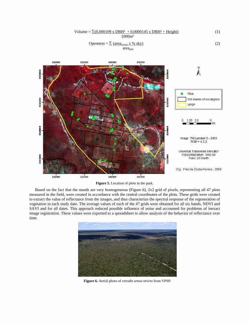
The sampling area totalizing 9400 m² is divided between 47 rectangular plots of 10
20 m, allocated in a non-random way to cover a fairly similar number of regeneration ages (based on the fact that each stand has undergone the same perturbation at the same time) as well as a good number of preserved cerrado plots of different areas within the park (Figure 5). Although sub-optimal, this approach ensured a good control of plot history based on the difference-images and on accounts of the park staff. The choice of the final location of the plots sought the sites representative of each age of the vegetation in regeneration but facility of access also had to be considered. All plots were located at least 20 meters from the edge of the stand or any other disturbance. For comparison purposes, a much degraded (stand 26 on Figure 5) area having suffered two fires and three episodes of eucalyptus plantations was also included in the sample.
All individuals having a circumference at breast height (CBH) of 10 cm or more were measured. When branches were present below breast height, the circumference was measured just below branching. In addition to CBH, trees height and crown diameter were measured. The crown openness (percent of sky visible from below the tree) was estimated from a standardized template (Macdonald et al., 1990) and hemispherical photographs were taken as support. The diameter at breast height (cm), basal area (m²/ha), volume (m³/ha) and stem density (n/ha) were calculated from the measurements collected in the field. The equation for volume (Equation (1)) was adjusted based of Rezende et al. (2006) that obtained a better adjusted constant for estimating volume of woody vegetation in the specific case of cerrado sensu-stricto. Openness (per unit area) was computed using Equation (2).
Volume = (0,000109 x DBH² + 0,0000145 x DBH² + Height)
(1)
1000m²
Openness =
(areacrown x % sky)
(2)
areaplot
Figure 5. Location of plots in the park.
Based on the fact that the stands are very homogeneous (Figure 6), 2x2 grid of pixels, representing all 47 plots measured in the field, were created in accordance with the central coordinates of the plots. These grids were created to extract the value of reflectance from the images, and thus characterize the spectral response of the regeneration of vegetation in each study date. The average values of each of the 47 grids were obtained for all six bands, NDVI and SAVI and for all dates. This approach reduced possible influence of noise and accounted for problems of inexact image registration. These values were exported to a spreadsheet to allow analysis of the behavior of reflectance over time.
Figure 6. Aerial photo of cerrado sensu-stricto from VPSP.

A database was assembled with physical and spectral data relating to each parcel. The measurements representing each plot were: crown openness, average height, average DBH, volume, basal area, stem density, age, reflectance in bands 1, 2, 3, 4, 5 and 7, NDVI and SAVI. Measurements of height and DBH in many plots did not show a normal distribution. For these variables, the median was used instead of the mean as the central tendency value. According to Farias, Soares and César (2003), the arithmetic mean is very sensitive to extreme values (very high or very low) and the median should be used when the histogram of the set is not symmetrical.
Aiming at producing a model for predicting the age of regeneration, relationships were established using correlation and regression between the vegetation structure and age and the remotely sensed values. The average reflectance of each polygon representing a plot was calculated for the bands and vegetation indices of the 2007 image (closest to the time of field data acquisition) to analyze the statistical relationship between the structural and spectral variables. Considering the short time between the 2007 image and the field work, no correction factor was used to compensate growth of vegetation.
The correlation coefficient between spectral and structural variables was computed considering a 95% confidence interval. Then, simple regression was calculated for those variables with a significant correlation. Graphs of dispersion were prepared for analyzing of results. Finally, multiple regression analysis was performed with the objective of creating a mathematical inversion model to estimate the age of vegetation since it was likely that no single variable would be sufficient to build a valuable model.
Since we could not rely on any previous study to estimate the age using multiple regression of reflectance values a stepwise method was applied to determine the best set of variables to explain the age of regeneration. At each step, this method includes an independent variable in the model to find the best regression equation. The correlation coefficient is the parameter that determines the inclusion of variables. To incorporate the variables into the equation, the significance of the correlation had to be at least 95%.
Graphs representing the spectral behavior of regeneration over time were generated, allowing comparison between the different ages. Plots were grouped by classes of age to facilitate the comparison and display. The classes were created using natural breaks.
3 RESULTS
3.1 Correlation
Pearson's Correlation was first computed for all variables pair using a 95% confidence interval. The linear correlation coefficient (r) expresses the strength of the linear relationship between two variables. Table 1 shows all variable pairs with their respective correlation. It can be observed that only a few of these correlation coefficients can be considered significant (in bold) and that these are quite low ranging from 0.295 to 0.418. The low correlations found in Table 1 can be partly explained by the heterogeneity of the floristic composition of the cerrado. The average DBH was the variable that best related with the spectral values of all bands. However, the single strongest correlation was found between age and band 5.
Crown Openness Height DBH Volume Basal Area Density Age Band 1 -0,035 0,122 0,307 0,268 0,264 -0,070 0,155 Band 2 -0,156 -0,102 0,285 0,068 0,077 -0,135 -0,102 Band 3 -0,208 -0,149 0,306 0,003 0,014 -0,190 -0,195 Band 4 -0,101 0,211 -0,198 0,031 0,015 0,117 -0,115 Band 5 -0,273 -0,275 0,313 -0,073 -0,054 -0,158 -0,418 Band 7 -0,246 -0,295 0,296 -0,100 -0,073 -0,142 -0,408 NDVI 0,213 0,196 -0,365 0,004 -0,010 0,219 0,191 SAVI 0,163 0,257 -0,412 0,012 -0,008 0,250 0,133
Table 1. Correlation coefficients (r). Values in bold show significance less than 0.05%.
The variable height showed significant correlation only with band 7. Table 1 shows the weak relationship between these two variables. The canopy does not present a uniform architecture due to the different heights of the species found and is generally heterogeneous in its configuration. This peculiarity modifies the spectral response through the amount of shade fraction and the shadow trees project on each other.
The structural variable DBH showed a significant correlation with almost all spectral variables. Only band 2 and band 4 showed no significant correlation with the DBH. The average DBH was the only variable having a significant correlation, though weak, with the vegetation indices (NDVI and SAVI).

The age has a significant correlation only with band 5 (r = -0.418) and 7 (r = -0.408) and both correlations are negative. We explain this somewhat peculiar result by two factors: 1) as the vegetation grows older, the amount of soil observable from above decrease and 2) the shade portion tend to increase as the taller trees project their shadow onto their neighbors. This is reinforces by the fact that all Landsat image are acquired in the morning (towards 9:30h), when shadows are still long.
3.2 Regression
Simple linear regression was used to determine the relationship between structural and spectral data. A simple regression between age and spectral variables produced the following coefficient of determination (r²): 0.175 for band 5 and 0.167 for band 7 (Figure 7). The coefficient of determination is a measure that expresses the level of accuracy of the prediction (Hair et al., 2005). This means that 18% of the age variation is explained by band 5 and 17% by band 7.
Figure 7. Graph of dispersion between age of vegetation and (a) band 5 and (b) band7.
A simple linear regression between DBH and the spectral variables with significant correlation (Figure 8) did not show high coefficients of determination because of the poor relationship between the variables. Comparing the graphs of dispersion of NDVI and SAVI in Figure 8 (e) and (f), SAVI appears to be slightly more correlated but no test was performed as to the significance of this difference. The fact that the SAVI is more sensitive to changes in soil reflectance might account for this difference. The same occurred with height (Figure 9).
Figure 8. Graph of dispersion between the average DBH of vegetation and (a) Band 1 with r² = 0.095, (b) Band 3 with r² = 0.094, (c) Band 5 with r² = 0.098, (d) Band 7 with r² = 0.088, (e) NDVI with r² = 0.133 and (f) SAVI with r² = 0.17.

Figure 9. Graph of dispersion between the average height of vegetation and band 7 (r² = 0.087).
Since no single variable was able to significantly explain the age through a strong coefficient of correlation or determination, multiple linear regression using the stepwise method of selection of variables was used to create an invertible mathematical model to estimate the age of the vegetation. Stepwise multiple regression was performed with the samples, since three plots were removed from the database for presenting some inadequacies (plots from stand 26). The age was considered as the response variable while bands 1, 2, 3, 4, 5, 7, NDVI and SAVI indices as explanatory. This method produced three possible equations to estimate the age (Table 2). The adjusted coefficient of determination (ra²), considers the number of explanatory variables and the sample size (Hair et al., 2005) and thus was used to compare the three models (Table 2).
Model Equation r ra² (A) 52,744 - 131,936 x Band 5 0,418 0,155 (B) 37,241 - 290,538 x Band 5 + 1244,416 x Band 1 0,709 0,478 (C) 90,363 - 325,178 x Band 5 + 1662,517 x Band 1 - 411,507 x Band 4 0,797 0,608
Table 2. Equations to estimate the age of vegetation.
The first equation (A) uses only band 5 as explanatory variable and has the lowest adjusted coefficient of determination (16%) among the three equations. When adding band 1 in equation (B), the adjusted coefficient of determination explains 48% of the age variation. The last equation (C) includes band 4 and shows the best result among the equations with ra
2 = 61% and a confidence interval of 95%. Like for the correlations, the weights of the constants for bands 4 and 5 are negative and we explain this apparent anomaly through the same mechanisms: the amount of shade and visible soil.
Multicollinearity is the almost linear dependence between the independent variables in a multiple regression model. The Variance Inflation Factor (VIF) has been calculated for each band included in the third regression equation (C) to detect the presence of multicollinearity among the predictors. VIF values of 2.26, 1.30 and 1.86 were obtained for bands 1, 4 and 5 respectively. These values being clearly lower than five, the influence of multicollinearity can be ruled out (Costa, 2008). Strangely, bands 1 and 4, taken individually did not show a significant correlation with the age but their inclusion in the regression model shows that their contribution to explain the age is unique and complementary. Residuals were also analyzed and proved to have a normal distribution and to be independent without any detectable trend.
There are many studies to estimate the structural parameters of vegetation from spectral variables, but few for Cerrado. Pinheiro (2008) tried to estimate above ground biomass using Landsat images and found low correlation between the spectral variables. Only bands 5 and 7 had a significant correlation with r = -0.559 and r = -0.508, respectively. Interestingly, the correlation he found for band 5 was also negative. Accioly et al. (2002) found relatively low correlation coefficient ranging from 0.33 to 0.60 between structural and the Landsat spectral bands.
3.3 Application of Model
Equation (C) was selected as the regression model to be inverted and applied to the input image to create an age map. Equation C was applied to the 2007 image with the objective of creating a map of the vegetation age. In addition of the equation, a 7x7 average filter was applied to smooth out the resulting image (Figure 10). The inversion of the model was applied to the image as a whole and beyond the limits of the VPSP. However, only areas classified as cerrado sensu-stricto should be considered since the model was only build for this particular physiognomy.

Figure 10. Age of the vegetation map of the VPSP and surrounding
It can be observed in Figure 10 that the vegetation within the old eucalyptus stands does not reach below 35 years of age unlike the rest of the park primarily covered by preserved cerrado that appears to be classified as being 35 years old (the oldest age that could be confirmed through the available images). Stand 26 (with three surveyed plots) shows a bluish color, indicating younger vegetation. The history of this stand would attribute a 16 years age but due a succession of strong disturbances, stand 26 is severely degraded and only regenerates with difficulty.
When comparing the age obtained by inverting the regression model with the estimated age of the plots, an average difference of 3.7 years (
= 2.67) is observed. Environmental factors such as soil, water availability, wind exposure and history of disturbances could probably explain the observed differences in the rates of regeneration. Different areas of savanna with the same age can appear 4 years older or younger, due to soil conditions. Still, in general, the map is quite consistent with the expected situation of the VPSP.
3.4 Spectral Trajectory of the Regeneration
The spectral trajectory of the regeneration covers the 1995-2007 period which corresponds to the last clear cutting of the eucalyptus stands in 1994. The reflectance values were obtained from the average reflectance of the pixels of the plots and the plots were grouped into classes of age to facilitate interpretation of the graphs. The values of reflectance for the years 2002, 2004 and 2005 were not available and were obtained from the averaging the previous and successive years. Only the spectral variables that entered in the model (regression equation C) were analyzed.
Figure 11 (a) shows the trajectory in the spectral region of mid-infrared (band 5) for the period. In general, the curves tend to follow the same behavior on different levels for different age class. The degraded cerrado (topmost curve) keeps a higher reflectance throughout the whole period probably because of the presence of exposed soil in this area (stand 26) and the amount of disturbance suffered that hinder a rapid regeneration. All the other age classes have curves on different levels but that tend, with time to come closer and reduce the gap between them. This is consistent with the expected behavior that with time all regeneration tends towards a climax state and therefore a more homogeneous aspect. It is interesting to note that the age classes are generally organized vertically according to their age. Local variations in the spectral-temporal curves are attributed to differences in precipitations, date of acquisition (38 days at the most), atmospheric quality and errors in the atmospheric and radiometric corrections. The temporal behavior in the near infrared (band 4) shows basically the same trend but with a reduced amplitude (Figure 11 (b)). The high reflectance values of the degraded savanna between 1996 and 1999 are possibly explained by the

amount of herbaceous strata during the first few years. Note that in 2007 the values of reflectance of all classes are very close. In the blue region of the visible (band 1) the spectral-temporal curves also display a similar behavior (Figure 11 (c)). However, the outer tips of the curves appear to all get to an almost unique point except for the degraded plots that maintain a somewhat higher reflectance.
(a) (b)
(c)
Figure 11. Spectral Trajectory of the Regeneration – (a) Band 5, (b) Band 4 and (c) Band 1.
The 13 years old plots started regenerating in 1994 (date of the last logging) therefore, these plots had only been regenerating for one year at the beginning of the graph. It is easily observable that for all three bands, the reflectance values are higher than all the remaining age classes. This is due to the fact that clear cut stands are affected by the presence of bare soil and are quickly invaded by grasses that have a bright reflectance in these bands and project very little shadow compared with their woody counterpart. This original gap rapidly decreases with the progressive appearance of trees. Analyzing the three graphs can be observed that the curves in general do not cross and maintain a consistent behavior.
Even in the field it is rather difficult to differentiate a cerrado with over 12 years of regeneration from an undisturbed cerrado. Both are visually similar in height and density. The same observation can be made for structural measurements. However, monitoring the spectral behavior of regeneration over time, we can say that 12 years is not enough for the reflectance curves to merge together. The spectral analysis shows a greater differentiation potential of the various classes of age of regenerating cerrado than field observation or even structural measurements.

4 CONCLUSIONS
Aiming at characterizing the age of cerrado regeneration using remote sensing data, this study used a combination of digital image processing and statistical techniques to understand this complex relationship. A simple technique of image subtraction of vegetation indices over a period of time proved efficient for determining the history of disturbances occurring in the vegetation, allowing us to date the age of the vegetation since it started regenerating.
We found through the analysis of correlation that the individual Landsat bands, have generally low correlations with the structural variables and with age. Some of these relationship, however low are still considered significant at a 95% confidence interval. The main difficulty in estimating the age from Landsat data or even from structural measuments (DBH, height, crown openness, volume, stem density) is due to heterogeneity of the cerrado canopy. Factors such as shading and soil interference can have a drastic effect on the reflectance values. Of all structural variables, DBH is the single best structural variable to correlate to the spectral variables but the strongest relationship with one single band (band 5) is the age.
Statistical analysis of the relationship between the age of regeneration and remote sensing data has shown that the use of multiple regression can significantly improves the model over simple regression. The model that proved best to estimate the age used bands 5, 4 and 1 of the Landsat-5 TM sensor. The model’s coefficient of determination of 61% compares well with other similar studies of cerrado. This is however, to our knowledge, the only such model for estimating the age of regeneration of cerrado. The model was successfully inverted to produce an age map of the cerrado which coincides with our general knowledge of the region.
The estimation of the age of each stand after a clear cut allows us to better understand the dynamics of natural regeneration of the savanna over time. The analysis of the spectral trajectory of cerrado regeneration over 13 different dates enabled us to distinguish a cerrado with more than 12 years of regeneration from a cerrado that has not been disturbed. The multitemporal-spectral analysis allowed better differentiation of age classes than the analysis of structural variables only.
Cerrado has long been considered a wasteland that had to be concurred and made productive. It is now recognized that cerrado’s biodiversity is rich and extremely important for the local populations. With this study, we have outlined the fantastic capacity of cerrado to regenerate after a clear cut even in the difficult climatic conditions available in Northern Minas Gerais. This capacity can however be easily hindered if the disturbances are frequently repeated over time. We suggest that land managers should try to use land management practices such as crop rotation to reduce the impact on the native vegetation and preserve this rapidly vanishing biome.
We hope for future study of the regeneration of cerrado to be able to account for edaphic factors such as water and nutrient availability and other abiotic factors like relief. We also recognize the importance for further analysis of including a larger number of samples and a perhaps more appropriated set of structural measurements more adapted to peculiarities of cerrado.
5 ACKNOWLEDGMENTS
This work was done within the framework of a master’s degree of Priscilla Costa-Pereira under the supervision of Philippe Maillard with partial scholarship from CAPES. The authors would like to thank the State Forestry Institute (IEF - MG) for encouraging this research and for their logistic support. We are also thankful to the National Institute for Space Research (INPE) for providing all the Landsat-5 scenes.
6 REFERENCES
Accioly, L. J. O., A. Pacheco, T. C. C. Costa, O. F. Lopes and M. A. J. Oliveira, 2002. Relações empíricas entre a estrutura da vegetação e dados do sensor TM/Landsat. Revista Brasileira de Engenharia Agrícola e Ambiental 6(3), 492–498.
Andrade, L. A. Z., J. M. Felfili and L. Violatti, 2002. Fitossociologia de uma Área de cerrado denso na Recor-IBGE, Brasília-DF. Acta Botânica Brasilica 16(2), 225–240.
Carvalho-Junior, O. A., R. F. Guimarães, E. S. Martins, A. P. F. Carvalho and R. A. T. Gomes, 2005. Aplicação do método de identificação espectral para imagens do sensor Aster em ambiente de cerrado. Revista Brasileira de Geofisica 23(2), 159–172.
Chavez Jr., P. S., 1988. An improved dark-object subtraction technique for atmospheric scattering correction of multispetral data. Remote Sensing of Environment 24(2), 459–479.

Costa, A. A. and G. M. Araújo, 2001. Comparação da vegetação arbórea de cerradão e de cerrado na Reserva do Panga, Uberlândia, Minas Gerais. Acta Botânica Brasilica 15(1), 63–72.
Costa, M. A., 2008. Módulo 5: multicolinearidade, considerações finais na modelagem múltipla linear. Departamento de Estatística - UFMG.
Coutinho, L. M., 1978. O conceito de cerrado. Revista Brasileira de Botânica 1, 17–23. Durigan, G., D. L. L. Nishikawa, E. Rocha, E. R. Silveira, F. M. Pulitano, lL. B. Regalado, M. A. Carvalhaes, P. A.
Paranaguá and V. E. L. Ranieri, 2002. Caracterização de dois estratos da vegetação em uma área de cerrado no município de Brotas, SP, Brasil. Acta Botânica Brasilica 16(3), 251–262.
Farias, A. A., J. F. Soares and C. C. César, 2003. Introdução Estatística. LTC. ISBN 8521612931. Goodland, R., 1971. A physiognomic analysis of the cerrado vegetation of central Brasil. The Journal of Ecology
59(2), 411–419. Hair, J. F., R. E. Anderson, R. L. Tatham and W. C. Black, 2005. Análise Multivariada de Dados. Bookman. ISBN
8536304820. Liang, S., 2004. Quantitative Remote Sensing of Land Surfaces. Wiley. ISBN 0471281662. MacDonald, R. C., R. F. Isbell, J. G. Speight, J. Walker and M. S. Hopkins, 1990. Australian Soil and Land Survey
Field Handbook (2nd ed.). Melbourne: Inkata Press. ISBN 0909605645. Mas, J. F., 1999. Monitoring land-cover changes: a comparison de change detection techniques. International
Journal of Remote Sensing 20(1), 139–152. Ministério das Minas e Energia, 1982. Projeto Radambrasil: levantamento dos recursos naturais. Folha SD.23.
Volume 29. Brasil. Mistry, J, 1998. Fire in the cerrado (savannas) of Brazil: an ecological review. Progress in Physical Geography
22(4), pp. 425-448. Mueller-Dombois, D. and H. Ellenberg, 1974. Aims and Methods of Vegetation Ecology. John Wiley and Sons.
ISBN 9780471622901. Myers, N., R. Mittermeier, C. Mittermeier, G. Fonseca and J. Kent, 2000. Biodiversity hotspots for conservation
priorities. Nature (403), 853–858. Nimer, E. and A. M. P. M. Brandão, 1989. Balanço Hídrico e Clima da Região dos Cerrados. Instituto Brasileiro de
Geografia e Estatística - IBGE. ISBN 852400164X. Oliveira, P. E.,1998. Cerrado: ambiente e flora, Chapter Fenologia e biologia reprodutiva das espécies de cerrado,
pp. 169–192. Planaltina, DF: EMBRAPA-CPAC. ISBN 8570750080. Pinheiro, E. S., 2008. Análises Ecológicas e Sensoriamento Remoto Aplicados Estimativa de Fitomassa de Cerrado
na Estação Ecológica de Assis, SP. PhD Tesis. São Carlos University. Reatto, A., J. Correa and S. Spera, 1998. Cerrado: ambiente e flora, Chapter Solos do bioma Cerrado, pp. 47–86.
Planaltina (DF). ISBN 8570750080. Resende, M. L. F. and L. L. Guimarães (2007). Inventários da Biodiversidade do Bioma Cerrado: Biogeografia de
Plantas. IBGE. Rezende, A. V., A. T. do Vale, C. R. Sanquetta, A. F. Filho and J. M. Felfili, 2006. Comparação de modelos
matemáticos para estimativa do volume, biomassa e estoque de carbono da vegetação lenhosa de um cerrado sensu-stricto em Brasília, DF. Scientia Forestalis (71), 65–76.
Sano, E. E., R. Rosa, J. L. S. Brito, L. G. Ferreira and H. S. Bezerra, 2009. Mapeamento da cobertura vegetal natural e antrópica do bioma Cerrado por meio de imagens Landsat ETM+. Anais XIV Simpósio Brasileiro de Sensoriamento Remoto, p. 1199-1206.

This document was created with Win2PDF available at http://www.win2pdf.com.The unregistered version of Win2PDF is for evaluation or non-commercial use only.This page will not be added after purchasing Win2PDF.