Characterization of the Coastal Phreatic Aquifer of the …€¦ · ABSTRACT - The Cervia shoreline...
12
ABSTRACT - The Cervia shoreline area and adjacent lan- dward belt represents a coastal flat zone characterized by a strong subsidence rate. Subsidence is mostly related to uncontrolled winning of gas and groundwater that started at the mid of past century. Massive land development exploded in 1950 bringing to a current 50% urbanization of the territory. The phreatic aquifer is located on the coastal sand dune, which was deposited during the last marine transgression (5.000-6.000 years old). The marine transgression reached inland as much as 2 km in the north and 1 km in the south. A marsh area developed inland, to the west, where later the romans built the Cervia saltworks. The stratigraphic reconstruction of the phreatic aquifer was made using 24 borehole records and high quality static penetration tests, chosen on the base of their reliability. The aquifer is mostly made up of medium to very fine grained sand (1-4 ϕ) with the medium-fine fraction well represented in proximity to the coast and a fine-very fine fraction represented inland. The sand contains some silty and loamy levels that are more abundant in the central part of the study area. The aquifer hydraulic conductivity has been measured from piezometric hydraulic tests using the tidal variation in sea level along the coast. We also obtained hydraulic con- ductivity estimates by using borehole lithologic records and static penetration tests and assigning to every granulometric class the relative average hydraulic conductivity value. The local horizontal and vertical hydraulic conductivity values have been interpolated in order to create maps of the distri- bution of these parameters. The horizontal hydraulic con- ductivity is usually one order of magnitude larger than the vertical one. The maps show a core of sediments with a high hydraulic conductivity both in the vertical and hori- zontal directions that is located in the central part of the study area between highway 16 and the railroad. The values tend to decrease seawards. The effective porosity of the aquifer is 0.15; while the transmissivity medium values is 3.9x10 -5 (m 2 /s). We also constructed maps of water table depth and aquifer surface and deep salinity. The piezometric level maps show that water table is usually located a few centime- tres below the mean sea level. The only areas where water table is above sea level are placed along the coastline and the canals. Most of the aquifer, therefore, does not have a hydraulic head able to stop the marine saltwater intrusion. As a result, most of the aquifer is salty; fresh water is pre- sent only in the form of bubbles floating over the salt water along the coastline and the drainage canals. KEY WORDS: Phreatic Aquifer, Coast, Petrophysics, Salt- Water Intrusion. RIASSUNTO - Il territorio di Cervia rappresenta una zona di piana costiera ed è caratterizzato da un forte tasso di subsi- denza, attribuibile alle spesso incontrollate estrazioni di gas e acque sotterranee profonde e freatiche. La crescente urba- nizzazione dell’area, esplosa negli anni ’50, ha portato ad un territorio urbano che occupa il 50% dell’area costiera. Oggi tale urbanizzazione è ancora spinta dall'attività turistico - alberghiera. L’acquifero si sviluppa sul cordone litoraneo sabbioso deposto durante la trasgressione marina avvenuta 5.000- 6.000 anni fa: la massima trasgressione raggiunse posizioni distanti dall’attuale linea di costa da 2 km a 1 km, proceden- do da nord a sud. A monte di questa, si formò l’area lagu- nare su cui poi furono costruite le Saline di Cervia. La ricostruzione della lito-stratigrafia dell’acquifero freatico è stata effettuata utilizzando 24 sondaggi geognosti- ci e prove penetrometriche statiche scelte sulla base della loro attendibilità. Le descrizioni litologiche sono state nor- malizzate utilizzando la scala granulometrica di Udden - Wenthworth. L’acquifero è costituito prevalentemente da sabbie da medie a molto fini (1-4 ϕ), con la componente media nella zona più prossima a costa e la componente fine prevalente- Characterization of the Coastal Phreatic Aquifer of the Cervia Area (NE Italy) Caratterizzazione dell’acquifero freatico costiero del Comune di Cervia ULAZZI E. (*), ANTONELLINI M. (**), GABBIANELLI G. (*) (*) Centro Interdipartimentale di Ricerca per le Scienze Ambientali, Via S. Alberto 163, 48100 Ravenna. Corresponding Author: [email protected] (**) Department of Geological and Environmental Sciences, Stanford University, CA (USA) Mem. Descr. Carta Geol. d’It. LXXVI (2007), pp. 277-288 figg. 9 - tabb. 2
Transcript of Characterization of the Coastal Phreatic Aquifer of the …€¦ · ABSTRACT - The Cervia shoreline...

ABSTRACT - The Cervia shoreline area and adjacent lan-dward belt represents a coastal flat zone characterized by astrong subsidence rate. Subsidence is mostly related touncontrolled winning of gas and groundwater that startedat the mid of past century. Massive land developmentexploded in 1950 bringing to a current 50% urbanization ofthe territory.
The phreatic aquifer is located on the coastal sand dune,which was deposited during the last marine transgression(5.000-6.000 years old). The marine transgression reachedinland as much as 2 km in the north and 1 km in the south.A marsh area developed inland, to the west, where later theromans built the Cervia saltworks.
The stratigraphic reconstruction of the phreatic aquiferwas made using 24 borehole records and high quality staticpenetration tests, chosen on the base of their reliability.
The aquifer is mostly made up of medium to very finegrained sand (1-4 ϕ) with the medium-fine fraction wellrepresented in proximity to the coast and a fine-very finefraction represented inland. The sand contains some siltyand loamy levels that are more abundant in the central partof the study area.
The aquifer hydraulic conductivity has been measuredfrom piezometric hydraulic tests using the tidal variation insea level along the coast. We also obtained hydraulic con-ductivity estimates by using borehole lithologic records andstatic penetration tests and assigning to every granulometricclass the relative average hydraulic conductivity value. Thelocal horizontal and vertical hydraulic conductivity valueshave been interpolated in order to create maps of the distri-bution of these parameters. The horizontal hydraulic con-ductivity is usually one order of magnitude larger than thevertical one. The maps show a core of sediments with ahigh hydraulic conductivity both in the vertical and hori-zontal directions that is located in the central part of thestudy area between highway 16 and the railroad. The valuestend to decrease seawards. The effective porosity of theaquifer is 0.15; while the transmissivity medium values is
3.9x10⁻⁵ (m2/s).We also constructed maps of water table depth and
aquifer surface and deep salinity. The piezometric levelmaps show that water table is usually located a few centime-tres below the mean sea level. The only areas where watertable is above sea level are placed along the coastline and thecanals. Most of the aquifer, therefore, does not have ahydraulic head able to stop the marine saltwater intrusion.As a result, most of the aquifer is salty; fresh water is pre-sent only in the form of bubbles floating over the salt wateralong the coastline and the drainage canals.
KEY WORDS: Phreatic Aquifer, Coast, Petrophysics, Salt-Water Intrusion.
RIASSUNTO - Il territorio di Cervia rappresenta una zona dipiana costiera ed è caratterizzato da un forte tasso di subsi-denza, attribuibile alle spesso incontrollate estrazioni di gase acque sotterranee profonde e freatiche. La crescente urba-nizzazione dell’area, esplosa negli anni ’50, ha portato ad unterritorio urbano che occupa il 50% dell’area costiera. Oggitale urbanizzazione è ancora spinta dall'attività turistico -alberghiera.
L’acquifero si sviluppa sul cordone litoraneo sabbiosodeposto durante la trasgressione marina avvenuta 5.000-6.000 anni fa: la massima trasgressione raggiunse posizionidistanti dall’attuale linea di costa da 2 km a 1 km, proceden-do da nord a sud. A monte di questa, si formò l’area lagu-nare su cui poi furono costruite le Saline di Cervia.
La ricostruzione della lito-stratigrafia dell’acquiferofreatico è stata effettuata utilizzando 24 sondaggi geognosti-ci e prove penetrometriche statiche scelte sulla base dellaloro attendibilità. Le descrizioni litologiche sono state nor-malizzate utilizzando la scala granulometrica di Udden -Wenthworth.
L’acquifero è costituito prevalentemente da sabbie damedie a molto fini (1-4 ϕ), con la componente media nellazona più prossima a costa e la componente fine prevalente-
Characterization of the Coastal Phreatic Aquifer of the Cervia Area (NE Italy)Caratterizzazione dell’acquifero freatico costiero del Comune di Cervia
ULAZZI E. (*), ANTONELLINI M. (**),GABBIANELLI G. (*)
(*) Centro Interdipartimentale di Ricerca per le Scienze Ambientali, Via S. Alberto 163, 48100 Ravenna. Corresponding Author: [email protected](**) Department of Geological and Environmental Sciences, Stanford University, CA (USA)
Mem. Descr. Carta Geol. d’It.LXXVI (2007), pp. 277-288
figg. 9 - tabb. 2

mente nella zona retrostante. Si tratta comunque di sabbiacon presenza di livelli limosi e/o limoso-argillosi, particolar-mente abbondanti nella zona centrale dell’area considerata.Per ricavare i parametri di conduttività idraulica dell’acqui-fero, abbiamo usato prove di pozzo basate sull’escursione dimarea integrate con i dati litologici sopra menzionati attri-buendo ad ogni classe granulometrica il relativo valoremedio di conduttività idraulica; sono stati poi calcolati ivalori medi puntuali su ogni singola colonna, successiva-mente interpolati per creare mappe di distribuzione dellaconduttività idraulica orizzontale e verticale. Le mappe evi-denziano un valore di conduttività idraulica orizzontalegeneralmente maggiore di un ordine di grandezza rispetto aquella verticale, con un nucleo di materiale a più elevataconduttività idraulica (orizzontale e verticale) nell’area cen-trale. I valori tendono poi a diminuire gradatamente versomare. La porosità efficace media dell’acquifero è di 0.15,mentre la trasmissività idraulica presenta un valore medio di3.9x10-5 (m2/s).
La ricostruzione di una banca dati relativa al periodo dimonitoraggio (giugno 2003 - maggio 2004) ha permessol’elaborazione di mappe delle isofreatiche, della salinitàsuperficiale e profonda. Le mappe hanno evidenziato che lequote freatiche sono raramente e di pochi cm sopra il livel-lo del mare, se non lungo la linea di costa, nelle zone duna-ri e in altre zone circoscritte e solo durante i mesi invernali,caratterizzati da una maggior ricarica. Ne deriva quindi che,per la legge di Ghyben-Herzberg, l’acquifero non presentaun carico idraulico in grado di ostacolare l’entrata direttadell’acqua di mare al fondo. Esso si presenta per lo più sala-to, con nuclei di acqua dolce superficiali e confinati, localiz-zati lungo la fascia costiera e in adiacenza ai canali di scolo,che determinano ricarica di acqua dolce durante i mesi piùpiovosi, mentre nei periodi di maggior siccità, a causa dellarisalita di acqua salata dal mare, determinano intrusione diacqua salata.
PAROLE CHIAVE: Acquifero freatico, Costa, Petrofisica,Cuneo salino.
1. - INTRODUCTION
The characterization of the coastal phreaticaquifer in the Cervia area has been carried out aspart of a study concerned with saltwater intrusionalong the coast (ULAZZI, 2004).
Coastal aquifers represent a precious waterresource especially in densely populated areassuch as California, Florida, Hawaii, The Nether-lands, Thailand and the northern Adriatic Italiancoast (BEAR et alii, 1999; SEGOL & PINDER, 1976;SONENSHEIN, 1995; SOUZA & VOSS, 1987). Theseaquifers are sensitive to changes in coast morpho-logy. Coast morphology is related to the naturalevolution of the shore environment, which is in astate of continuous change (CARTER, 1988), andto the human intervention on the territory and onland use.
The reason for this high vulnerability stemsfrom the process of saltwater intrusion, whichresults from the ingression of a high-density sal-
twater wedge underneath lower density freshwa-ter with an inland origin. A diminished freshwaterhydraulic head or gradient, due to natural processesor human activities, causes the saltwater intrusion.
The relationship controlling saltwater intru-sion is the well-known Ghyben-Herzberg (1889-1901) relationship (FETTER, 2001).
2. - STUDY AREA
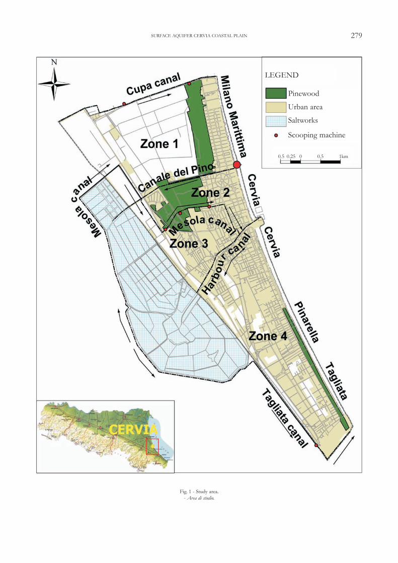
The study area includes the coastal phreaticaquifer of the Cervia area (fig. 1); the zone inve-stigated has an extension of 20 km2.
The territory of Cervia is located in a flat coa-stal plain and is characterized by a strong subsi-dence rate (0.42 meters in the period 1950-2004).The subsidence is caused by uncontrolled extrac-tion of gas and groundwater (504 active wells,232 of which along the coast line). Groundwaterwinning was particularly intense before 1950,when the city water supply system was not con-nected to the Romagna Aqueduct.
Starting from the 1950’s, the coastal areaunderwent an intensive urban development thatbrought to 50% urbanization of the territory (fig.1). The remaining land consists of farmland andpinewoods. The pinewoods are located in protec-ted areas belonging to the Regional Park of thePo delta.
A dense network of land reclamation draina-ge canals connected to water scooping machinescharacterizes the territory. The most importantdrainage canals are the Scolo Cupa and the CanaleMesola di Montaletto (fig. 1).
The roman age Cervia’s saltworks are located1.5 km inland (fig. 1): the Canale del Pino bringsmarine water to the saltworks. The city harbourcanal and the Canale del Pino favour surface saltwa-ter intrusion inland.
3. - GEOMORPHOLOGY
During the last glacial period (75.000-15.000years ago), the Cervia territory was located withina large alluvial plain made up by marshes andswampy areas extending all along the NorthAdriatic Sea. The following Holocenic orFlandrian transgression (started about 15.000years ago), brought back the seawater into theNorth Adriatic Sea and drowned the continentaldeposits. The maximum marine transgression(5.000-6.000 years ago during the post-glacialoptimum) extended beyond the present coastline(BONDESAN et alii, 1978).
278 ULAZZI E. - ANTONELLINI M. - GABBIANELLI G.
279SURFACE AQUIFER CERVIA COASTAL PLAIN
Fig. 1 - Study area.- Area di studio.
Pinewood
Urban area
Saltworks
Scooping machine
LEGEND
0.5 0.25 0 0.5 1km

During the last 2.000 years, there have beenpositive/negative sea level fluctuations that com-bined with local subsidence and tectonic upwardmovements have brought to local beach progra-dation and erosional retreat. Beach progradationformed sandy dunes, whereas erosion formedswampy lagoons.
The predominant progradational trend led tothe formation of a series of coastal sandy bodiescomposed by dunes and sandy beaches with inter-vening marshes and lagoons where peaty silts andclays have been deposited (BONDESAN et alii,1978).
Three morphologic units are recognizable inthe Cervia area (fig. 2). The Savio river alluvialplain represents the first unit.
The second unit is characterized by depres-sions of an ancient lagoon, formed during the lastmarine transgression. The lagoon formed as aresult of compaction driven subsidence of deltasediments (CASTIGLIONI et alii, 1990). At presenttime, the lagoon area has been in part land reclai-med and for the rest is occupied by the Cervia sal-tworks (VEGGIANI, 1971) and, southward, by themarshes of Valle Felici.
The third unit includes the coastal sandy prism
280
Fig. 2 - Geomorphologic map of the Cervia area (modified from SANTINI, 1992).- Carta geomorfologica della zona di Cervia (da SANTINI, 1992, modificata).
ULAZZI E. - ANTONELLINI M. - GABBIANELLI G.
2.5 1.25 0 2.5 5 km
Alluvial plain with clayey-silty sedimentsFluvial hump and floodingCoastal sand duneExisting sand duneBuried sand duneSmoothed sand duneSaltworksExtinct streamTrasgression limitInternal limit of the lagoonRecent-ancient sand dune limitCervia’s boundary
LEGEND

(the phreatic coastal aquifer), placed between thelagoon zone and the shoreline. The sand prism isformed by a series of adjacent sand bodies depo-sited at various positions of the coastline duringthe regression period. Regression that startedapproximately 2.000 years ago. It has a triangularshape in cross section and trapezoid in map view.The width ranges from 4 km in the north to 1 kmin the south. The sand prism thickness variesfrom 18 m in the north to 9 m in the south(SANTINI, 1992). The sand body is bound to thewest by the clay of the lower confining layer rea-ching the surface.
Sub-parallel zones of different topographicelevation are recognizable in this third unit. Theeasternmost part of the study area includes recentdunes. These can be observed in their pristinestate only in the Milano Marittima and Pinarellapinewoods, because of the strong urbanizationthat almost completely destroyed their originalshapes. The sand beach belongs to the geomor-phic third unit. The beach is approximately 100 mwide and edges entirely the eastern border of thestudy area.
Sand and gravel quarries are located within theinner part of the third unit (VEGGIANI, 1960).The sand and gravel deposits represent southernfluvial sediments formed during the maximum ofthe marine transgression (ELMI, 1991) due to N-NW oriented along-shore currents.
4. - LITHOSTRATIGRAPHY
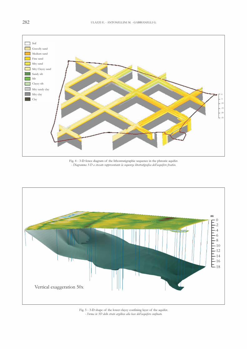
We reconstructed the lithostratigraphy of thephreatic aquifer in a way to define the shape anddepth of the lower confining layer, as well as tocharacterize its petrophysical parameters (hydrau-lic conductivity, permeability, porosity). We stu-died the lithologic sequence using 24 boreholerecords and some selected (based on reliabilityand calibration) high quality static penetrationtests.
The lithology reconstruction is restricted to alimited area (see zones 2 and 3 in fig. 1), becauseof the non-uniform spatial distribution of theborehole data. Given the homogeneous deposi-tional environment in the area and the strai-ghtness of the shoreline, we extend the lithologyinterpretation to zones adjacent to the one withborehole control.
We chose the Udden-Wentworth granulome-tric scale to make uniform the lithologic descrip-tions. Figure 3 shows the typical borehole lito-stratigraphy for the area. Plotting and data repre-sentations have been performed using the
RockworksTM software and a GeographicInformation system. The software used allowscreating a fence diagram that gives a three-dimensional visualization of aquifer litostrati-graphy (fig. 4).
The aquifer is made up of medium to veryfine grained sand (1-4 phi) with the medium-finefraction well represented close to coast and thefine-very fine fraction present inland. The sandcontains some silty and loamy levels more abun-dant in the central part of the study area (fig. 4).It is therefore apparent, that the E layer of theaquifer can be considered a rather heterogenousporous media.
281
Fig. 3 - Typical borehole litostratigraphy of the area.- Tipico profilo litostratigrafico per la zona di studio.
SURFACE AQUIFER CERVIA COASTAL PLAIN
Soil
Gravelly sandMedium sand
Fine sand
Silty sand
Silty Clayey sand
Sandy silt
SiltClayey siltSilty sandy clay
Silty clay
Clay
- 15
- 10
- 5
5
282
Fig. 4 - 3-D fence diagram of the lithostratigraphic sequence in the phreatic aquifer.- Diagramma 3-D a steccato rappresentante la sequenza litostratigrafica dell’acquifero freatico.
Fig. 5 - 3-D shape of the lower clayey confining layer of the aquifer.- Forma in 3D dello strato argilloso alla base dell’acquifero confinato.
ULAZZI E. - ANTONELLINI M. - GABBIANELLI G.
Vertical exaggeration 50x
0-2-4-6-8-10-12-14-16-18
Soil
Gravelly sand
Medium sand
Fine sand
Silty sand
Silty Clayey sand
Sandy siltSilt
Clayey silt
Silty sandy clay
Silty clay
Clay
0
-5
-10
-15
-20
-25

The lower confining layer of the aquifer is aconsolidated clay layer (fig. 5): its depth increasesin an E-W direction, from -18 m m.s.l. near thecoastline to 0 m m.s.l. in proximity to the maxi-mum marine ingression line. The clay-confininglayer deepens in the N-NW direction, as observedalso by other authors (VEGGIANI, 1960;BONDESAN et alii, 1978; ELMI, 1991).
5. - PETROPHYSICAL DATA
The major difficulty we encountered in petro-physical properties characterization has been thelack of well tests. We solved this problem bymaking tidal well tests on piezometers close to theshoreline. The method we used is the one descri-bed by FETTER (2001), and by JACOB (1950),which is valid for a confined aquifer but can beextended as a valid approximation to unconfinedaquifers, if the range of tidal fluctuations is smallcompared with the thickness of the saturatedaquifer. In our case, the thickness of the aquifer is18 m and the range in tidal fluctuations is lessthan 0.8 m. For this reason, we think that themethod of the tidal well tests is a valid approxi-mation also in our case.
The governing mono-dimensional flow equationcan be used to describe the flow of water into andout of the aquifer as the tide changes. If Ho is theamplitude of the tidal change and to is the tidalperiod, at any distance x, inland from the coast,the amplitude of the tidal fluctuations Hx is givenby (JACOB, 1950):
where Sy and T are the aquifer gravific water andtransmissivity. The time lag, tτ , between the hightide and the peak of the water level (or low tideand the low point in the water level) is given by
rearranging the formula above by knowing thesaturated aquifer thickness, b, we can compute thehydraulic conductivity, K,
The variation of water level in a piezometer loca-ted 40 m from the shoreline is given in figure 6,
283
)/exp( 00 TtSx yx HH π−=
TStx yt πτ 4/0=
(1)
(2)
bSt
txK y
πτ 40
2
⎟⎟⎠
⎞⎜⎜⎝
⎛= (3)
Fig. 6 - Sea tide excursion and variation of water level in a piezometer located 40 m from the shoreline.- Escursione mareale e variazione della tavola d’acqua in un piezometro a 40 m dalla linea di riva.
SURFACE AQUIFER CERVIA COASTAL PLAIN

where we can also measure the lag time tτ.. Table1 summarizes some of the hydraulic conductivityvalues that we obtained.
Obviously, these figures represent values forhydraulic conductivity averaged at the scale oftens of meters, which is the scale of the experi-ment performed, and, therefore, represent thebehaviour of the aquifer as a whole in the beltclose to the shoreline. These values have beencompared and integrated with estimates obtainedvia empirical formulas (FETTER, 2001) and thelithologic descriptions from the boreholes.
The 12 lithologic classes (fig. 3) observed inthe borehole data have been compacted to 5 gra-nulometric classes. For each granulometric classwe assigned the relative medium hydraulic con-ductivity value by using the formula of Hazen asreported in FETTER (2001). The local (at a bore-hole) average values of horizontal (4) and verticalhydraulic conductivity (5) and of trasmissivity (6)have been calculated using the formulas below:
where:Khavg = medium horizontal hydraulic
conductivity (m/s);Kvavg = medium vertical hydraulic
conductivity (m/s);Km = m-level hydraulic conductivity (m/s);K = medium hydraulic conductivity (m/s);
bm = m-level thickness (m);b = aquifer thickness (no clay) (m).T = transmissivity (m2/s);
The average values obtained at any boreholehave then been interpolated to create maps of thehydraulic conductivity distribution (horizontaland vertical) in the aquifer.
The horizontal hydraulic conductivity is usual-ly one order of magnitude larger than the verticalone. The spatial variability of the hydraulic con-ductivity is reported in fig. 7: the maps show acore of sediments with an high hydraulic conduc-tivity, both in the vertical and horizontal direc-tions, located in the central part of the study area.The values tend to decrease seawards.
Some estimates of effective porosity for thedifferent lithologic levels in the aquifer have beenmade making use of data present in the literature.In particular, the values have been extrapolatedfrom the calibration of log-based permeabilitywith core data for the Lower Hibernia Formationpublication (WATSON et alii, 2000), obtaining aneffective porosity value for each lithology-K classconsidered.
The average effective porosity of the aquiferis about 0.15, whereas the transmissivity has anaverage value of 3.92 x10⁻⁵ (m2/s) (tab. 2).
6. - FIELD MONITORING
A field monitoring campaign aimed to assessthe seasonal variability of saltwater intrusion inthe phreatic aquifer has taken place from June2003 to May 2004. The monitoring has been per-formed on a total of 187 stations (piezometersand canals) and included water table depth, tem-perature, and electric conductivity. Electric con-ductivity was converted in salinity values usingLewis e Perkins (1981) equation (UNESCO, 1983).
284
x ( m ) t o ( h ) t ( h ) S y b ( m ) K ( cm /s )
40 16 5 0 , 2 18 2 . 4x10 - 2
40 15 5 0 , 18 18 2 . 1 x10 - 2
40 13 6 0 , 18 18 1 . 3 x10 - 2
Tab. 1 - Summary of hydraulic conductivity values obtained.
- Riassunto dei valori di conduttività idraulicaottenuti.
∑=
=n
m
mmh
bbKavgK
1
∑=
= n
m m
mv
Kb
bavgK
1
bKT =
(4)
(5)
(6)
K h A v e r a g e 2 . 2 E - 4 ( cm /s ) K v A v e r a g e 4 . 6 E - 5 ( cm /s ) k i h A v e r a g e 2 . 5 E - 9 ( cm 2 ) k i v A v e r a g e 5 . 3 E - 10 ( cm 2 ) E f f e c t ive Po r o s i t y n e 0 . 15 Ave r age T r asm is s iv i t y 3 . 9 E - 5 ( m 2 /s ) S y 0 . 15
Tab. 2 - Summary of the aquifer hydraulic characteristics.- Riassunto delle caratteristiche idrauliche
dell’acquifero.
ULAZZI E. - ANTONELLINI M. - GABBIANELLI G.

We implemented the data collected in a GISsystem (Geographic Information System) usingArcGis 8.2. Using this database, we producedwater table maps for zones 2 and 3 (see fig. 1).The seasonal piezometric maps (fig. 8) evidence awater table depth located a few centimeters belowmean sea level. The few areas above sea level arelocated along the coastline and the canals (Canaledel Pino, harbour canal and Canale Mesola diMontaletto). The canals, in fact, are often rechar-ging the phreatic aquifer. The water table depthfluctuates seasonally with an average range of 0.9m. The maximum-recorded value of 0.82 m(m.s.l.) in winter time and the minimum recordedvalue in summer time of -1.06 m (m.s.l.). Duringthe fall-winter period the water table depth tendsto stay above the mean sea level, thanks to thelarge precipitations and high water levels in thedrainage canals.
On the basis of the water table maps just
discussed, it is apparent that most of the aquiferdoes not have a hydraulic head able to stop thesaltwater intrusion at its base. The saltwater -fresh water interface does not reach the bottomof the confining layer and it does not prevent sal-twater ingression from the sea, if not in the win-ter period and in proximity to the drainage canals.
The surface salinity maps (fig. 9) show that theharbour canal and the Canale del Pino, as well asthe sea outlets of the drainage canals, cause surfa-ce saltwater intrusion: the salinity value is about30-34 g/l (same as the sea value) in the aquifer upto a distance of 250 m normal to the channel axesand inland from the sea up to 2 km. The salinityis also high in proximity to the pinewoods and tothe water scooping machines, as a consequence ofthe saltwater up-coning caused by the pinewoodsevapotranspiration and the waterwork systemsdrainage (Ghyben-Herzberg law). The salinityvalue is smaller than 2-3 g/l along the coastline.
285
Fig. 7 - Map of hydraulic conductivity: horizontal (above) and vertical (below).- Carta rappresentante la conduttività idraulica media orizzontale (sopra) e verticale (sotto).
SURFACE AQUIFER CERVIA COASTAL PLAIN

286
Fig. 8 - Maps of water table depth for the summer and winter periods.- Carte di profondità della freatica per i periodi invernale ed estivo.
ULAZZI E. - ANTONELLINI M. - GABBIANELLI G.

287
Fig.
9 - S
easo
nal v
ariat
ion
in su
rfac
e sa
linity
dist
ribut
ion.
- Var
iazion
e sta
giona
le ne
lla d
istrib
uzion
e dell
a sa
linità
supe
rficia
le di
falda
.
SURFACE AQUIFER CERVIA COASTAL PLAIN

The maps also show the influence of the Ca-nale Mesola di Montaletto on the seasonal salinityvalues: during the fall-winter period, characterizedby large precipitations, it recharges the aquiferwith fresh water, whereas during the summerperiod it recharges the aquifer with saltwater.
From the analysis of all maps produced, it istherefore apparent that the phreatic coastal aqui-fer of Cervia is reduced to a few fresh water bub-bles floating over the marine saltwater. The thick-ness of such bubbles changes seasonally as a fun-ction of the precipitations and/or of fresh waterrecharge from the canals.
7. - CONCLUSION
The saltwater intrusion study that we perfor-med, points out the need for an accurate charac-terization of the aquifer porous media and itspetrophysical properties. The hydraulic propertiesof the aquifer, in fact, control the extent of sal-twater intrusion. As it is apparent from the com-parison of salinity distribution maps and thelithologic maps of the aquifer, high porosity andhydraulic conductivity sediment bodies promotesaltwater intrusion, whereas low porosity and lowhydraulic conductivity sediments prevent saltwa-ter intrusion. This is of paramount importance tounderstand the aquifer’s flow dynamic in the dif-ferent seasons and the causes (subsidence, wellpumping, land reclamation, etc.), that brought itto the present disturbed state. In particular theaquifer characterization with the tidal well testshas shown that the sandy layers close to the sur-face have a very high hydraulic conductivity in theorder of 1.2-3.4x10⁻² cm/s and they are the mostvulnerable to saltwater intrusion. The finer levelsin the aquifer contribute to reduce the overallaquifer hydraulic conductivity in the verticaldirection by about one order of magnitude, whe-reas they have not much effect on the aquifer’shorizontal permeability.
Acknowledgments
We would like to thank the two anoymous reviewers that haveimproved enormously this paper. We also ackowledge the Emilia-
Romagna region, the Cervia Municipality, the Consorzio diBonifica Savio e Rubicone and GEA progetti s.a.s. for providingsome of the data presented in this paper.
REFERENCES
BEAR J., CHENG A.H.-D., SOREK S., OUAZAR D. & HERRERA I.(1999) - Seawater intrusion in coastal acquifer - Concepts, methodsand practices. Kluvert Acad. Publisher.
BONDESAN M., CALDERONI G. & DAL CIN R. (1978) - Il lito-rale delle province di Ferrara e di Ravenna (alto Adriatico):Evoluzione morfologica e distribuzione dei sedimenti. Boll. Soc.Geol. It., 247-287.
CARTER R.W.G. (1988) - Coastal Environments: An Introductionto the Physical, Ecological and Cultural System of Coastlines.Academic Press, London: 431-443.
CASTIGLIONI G.B., BONDESAN M & ELMI C. (1990) -Geomorphological mapping of the Po Plain (Italy), with an exam-ple in the area of Ravenna. Z. Geomorphology N.F., Suppl.-Bd. 80, Berlin: 35-44.
ELMI C. (1991) - Anomalie del reticolo idrografico nell’Appenninocentro-settentrionale: evoluzione geomorfologica e attività neotettoni-ca. Giorn. di Geol., serie 3, 53/2.
FETTER C.W. (2001) - Applied hydrogeology. Prentice hall,fourth edition.
JACOB C.E. (1950) - Flow of ground water. In: H. ROUSE Ed.Engineering hydraulics, John Wiley, New York, 321-86.
SANTINI E. (1992) - Ricostruzione degli eventi deposizionali tardo-pleistocenici e olocenici nella piana costiera cervese. MS Thesis,University of Bologna.
SEGOL G. & PINDER G.F. (1976) - Transient simulation of saltwater intrusion in south eastern Florida. Water Resour. Res. 12:65-70.
SONENSHEIN R.S. (1995) - Delineation of Saltwater Intrusion inthe Biscayne Aquifer, Eastern Dade County. Florida, 1995.Water-Resources investiogation Report 96-4285. U.S.Department of the interior - U.S. Geological Survey.
SOUZA W.R. & VOSS C.I. (1987) - Analysis of an anysotropic coa-stal aquifer system using variable-density flow and solute transportsimulation. Journal of Hydrogeology, 92: 17-41.
ULAZZI E. (2004) - Studio dell’intrusione di acqua salata nell’ac-quifero freatico costiero del Comune di Cervia. PhD Thesis,University of Bologna.
UNESCO (1983) - Algorithms for computation of foundamental pro-perties of seawater. n.p. fofonoff and r.c. millard jr. UNESCOtechnical papers in marine science.
VEGGIANI A. (1960) - Le vicende geologiche del territorio cervese.In: O. MARONI & A. TURCHINI Eds. “Cervia Natura e sto-ria”. Maggioli Editore: 13-26.
VEGGIANI A. (1971) - Le ultime vicende geologiche del territoriocervese e dell’area adriatica settentrionale. Studi Romagnoli 22,Fratelli Lega Edizioni, Faenza: 3-17.
WATSON R.N., FONDYGA T., SCOTT B. & SINCLAIR I. (2000)- Calibration of log-based permeability alternatives with core data.Lower Hibernia Formation, well B-16_17, Hiberia Field,Newfoundland. CSEG Conference. Conference theme:Geo Canada 2000 - The Millennium Geoscience Summit.
288 ULAZZI E. - ANTONELLINI M. - GABBIANELLI G.