Characteristics of sub-surface sediments in southern ...
64
ISSN 2463-6029 (Print) ISSN 2350-3432 (Online) Characteristics of sub-surface sediments in southern Stella Passage, Tauranga Harbour 2019 ERI report number 133 Prepared for the Port of Tauranga Ltd By Vicki Moon, Willem de Lange Environmental Research Institute Faculty of Science and Engineering The University of Waikato, Private Bag 3105 Hamilton, New Zealand
Transcript of Characteristics of sub-surface sediments in southern ...

ISSN 2463-6029 (Print) ISSN 2350-3432 (Online)
Characteristics of sub-surface sediments in southern Stella Passage, Tauranga Harbour
2019
ERI report number 133
Prepared for the Port of Tauranga Ltd
By Vicki Moon, Willem de Lange
Environmental Research Institute
Faculty of Science and Engineering
The University of Waikato, Private Bag 3105
Hamilton, New Zealand


1
Table of Contents TableofContents.............................................................................................................................................1Listoffigures...................................................................................................................................................................................1Listoftables....................................................................................................................................................................................2
Executivesummary........................................................................................................................................3Introduction.....................................................................................................................................................4Methods.............................................................................................................................................................4Sub-surfacefacies...........................................................................................................................................7Blackfinesands.............................................................................................................................................................................7Greyshellysands...........................................................................................................................................................................7Darkbrownorganicsilts...........................................................................................................................................................8Paleyellowpumiceoussands..................................................................................................................................................8Olive-greensands..........................................................................................................................................................................9Palegreyquartzsands...............................................................................................................................................................9Minorunits....................................................................................................................................................................................10
Leapfrogmodel.............................................................................................................................................11Conclusion......................................................................................................................................................15References......................................................................................................................................................16
List of figures Figure1.ConsenteddredgingandpossiblefuturedevelopmentofthePortofTaurangawithinthesouthern
StellaPassage..............................................................................................................................................................................4
Figure2.SeismiclineswithinthesouthernStellaPassagethatintersecttheproposeddredgingarea.Thesurveywasundertakenon11January2018....................................................................................................................5
Figure3.Locationofborehole(BH),CPT,andseismicdilatometertesting(sDMT)sitesinsouthernStellaPassage(AppendixA,OPUS,2019).ThisreportmainlyfocussesonboreholesBH15-19,andCPTsitesCPT21-28......................................................................................................................................................................................6
Figure4.Comparisonof1986and2015marinechartsforthevicinityofWhareroaPtfollowingconstructionoftheTaurangaHarbourCrossing.Scourhasoccurredeastofthebridge,withshoalingtothewestcreatingasmalldeltaencroachingonStellaPassage....................................................................................................7
Figure5.LocationofexcavatedpitinseabedusedastemporarystorageofcleanspoilfrommaintenancedredgingpriortotransfertostoragepilesonSulphurPoint..................................................................................10
Figure6.LocationsoftransectsthroughtheLeapfrogmodelrelativetoStellaPassageandtheareaofproposedcapitaldredging...................................................................................................................................................11
Figure7.East-westslicesthroughtheLeapfrogsubsurfacestratigraphicmodel,fromtheexistingshippingchannelinthenorth(top)tothemarinainthesouth(bottom),showingthedistributionofthe4mainunitsdiscussedinthetext.Theproposed14.5mchanneldepthismarked......................................................12
Figure8.North-southslicesthroughtheLeapfrogsubsurfacestratigraphicmodel,fromtheMtMaunganuiwharvesintheeast(top)totheSulphurPtwharvesonthewest(bottom),showingthedistributionofthe4mainunitsdiscussedinthetext.Theproposed14.5mchanneldepthismarked................................13
Figure9.SlicesthroughtheLeapfrogsubsurfacestratigraphicmodel,fromtheexistingshippingchannelinthenorth(top)tothemarinainthesouth(bottom),showingthedistributionoftheestimatedproportionsoffinesasdiscussedinthetext.Theproposed14.5mchanneldepthismarked...................14
2
Figure10.SlicesthroughtheLeapfrogsubsurfacestratigraphicmodel,fromtheMtMaunganuiwharvesintheeast(top)totheSulphurPtwharvesonthewest(bottom),showingthedistributionoftheestimatedproportionsoffinesasdiscussedinthetext.Theproposed14.5mchanneldepthismarked........................................................................................................................................................................................................15
List of tables Table1.Summaryofestimatedareasfortheuppersurfaceandvolumesforthemainfacieswithindredged
areaaboveadepthof16m(channeldepthof14.5mplus1.5mover-deepeningallowance).Theolive-greensandsfacieswasomittedduetoits’veryimitedextent.Estimatedvolumesforspecifiedrangesoffinescontentarealsosummarised....................................................................................................................................16
3
Executive summary ThePortofTaurangaisconsideringportdevelopmentsthatwouldrequirecapitaldredgingofasectionof thesouthernStellaPassagetoachievedepthscomparableto thenorthernStellaPassage.Seismicprofiles,coresamples,andCPTdatawerecollectedbytheUniversityofWaikatoandOPUSfortheareaimpactedbyproposeddevelopment.
Thecoresampleswereanalysedforsedimenttexture,includingassessmentofthefines(silt+clay)content.Fourmainstratigraphicunitswereidentifiedfromtheavailabledata.Thesewere,inorderofincreasingstratigraphicdepthandage:Holocenesand;Pleistocenealluvialfan;Pleistoceneorganicsilt;andPleistoceneterrestrialandshallowmarinesand.Ingeneral,thefinescontentincreasedwithdepthandage.YoungerunitsthinsouthwardsalongStellaPassage,resultinginincreasingfinescontentsouthwardsalongthechannel.A 3Dmodel of the subsurface stratigraphywas created by Leapfrog and is available forviewing, including the ability to generate slices in any required orientation. Thismodelhighlights thetrends in finescontentabove,aswellasshowingthatsedimentsalongthewesternmarginoftheproposeddredgedareahavethehighestproportionoffines.ApartfromtheHolocenesands,mostofthesedimenttobedredgedislikelytoexceed25%finescontent,and,therefore,wouldrequireandissuitablefordisposalatoffshoresiteH2.

4
Introduction ThePortofTaurangahasconsenttoextendtheshippingchannelssouthwardswithinStellaPassage,andisconsideringfurtherdevelopmentsinthisarea(Figure1).Priortopreviouscapital dredging campaigns within Stella Passage the characteristics of sub-surfacesedimentswithinthedredgedareawereinvestigated.ThefindingsofthesestudiesintermsoftheirsedimentaryenvironmentinterpretationaresummarisedinDavisandHealy(1994),Jorat et al (2017), and MacPherson et al (2017). The characteristics of the sub-surfacesedimentsaredetailedinMoonetal(2013),anddeLangeetal(2014).
Figure1.ConsenteddredgingandpossiblefuturedevelopmentofthePortofTaurangawithinthesouthern
StellaPassage.
It is proposed thatmaterial dredged from southern Stella Passagewill be discharged atexistingoffshoredisposalsitesH1andH2.Sedimentcontaining>25%ofsedimentfinerthan63µmwillbedischargedtositeH2.
This report summarises the results of a seismic survey, borehole descriptions, sedimenttexturalanalyses,andCPTdata,thatidentifyareaslikelytocontainsedimentthatexceedsthe25%thresholdforfinescontent.
Methods Seismicdatawerecollectedon11January2018usingSounderSuite-USBsoftwareconnectedtoaKnudsenPingerSBPdualfrequencyCHIRPportableseismicreflectionsystemoperatingat3.5kHzforseismicand200kHzforbottomlocation.PositionaldatawerealsologgedbySounderSuite-USB from an OTF kinematic DGPS navigation system. Since the surveyinvolvedanareanotpreviouslydredged,thePingerwasconfiguredtoachievepenetrationto a depth of at least 20m RL, which resulted in relatively low resolution compared to

5
shorterrangesettings.TheresultingdatawereexportedtoSEG-YformatandprocessedinMatlab,usingroutinesfromthepackageSegyMAT.Figure 2 indicates the locations of seismic survey tracks that intersected the potentialdredgingareasshowninFigure1.Aninitialanalysisoftheseismicdataindicatedthatthehigherdensityofdataobtaineddidnotsuggestadifferentsub-surfacestructurefromthatproposedbyJoratetal(2017)basedonanearlierlowtrackdensityseismicsurvey.
Figure2.SeismiclineswithinthesouthernStellaPassagethatintersecttheproposeddredgingarea.The
surveywasundertakenon11January2018.
The initial seismic analysis was used to inform the placement of boreholes to providesediment samples for textural analysis, and stratigraphic information to assist with theinterpretationoftheseismicdata.CPTsiteswerealsospecifiedduetothesuccessfuluseofCPT data for characterising sub-surface stratigraphy in previous studies (viz. Jorat et al,2017).
Figure3showsthelocationsofborehole(BH),CPTandseismicdilatometertest(sDMT)siteswithinsouthernStellaPassagesampledbyOPUS(2019).SitesBH15-19andCPT21-28werenotinterpretedbyOPUS(2019)andwerespecificallyintendedtocharacterisethesedimentpotentially being dredged for this report. Data from all siteswere used to develop a 3Dstratigraphic model for the dredged area. Boreholes BH15-19 were located along thetransect discussed by Jorat et al (2017) to allow comparisonswith their interpretation,whichwas based on CPT data collected by the University of Bremen submersible GOSTsystem. CPT21-23were located adjacent to these boreholes to allow the CPTdata to becorrelatedwithstratigraphicinformationfromtheboreholes.TheremainingBHandCPTsitesweredistributedtoobtainthemaximumcoveragewithintheavailablebudget.

6
Figure3.Locationofborehole(BH),CPT,andseismicdilatometertesting(sDMT)sitesinsouthernStella
Passage(AppendixA,OPUS,2019).ThisreportmainlyfocussesonboreholesBH15-19,andCPTsitesCPT21-28.
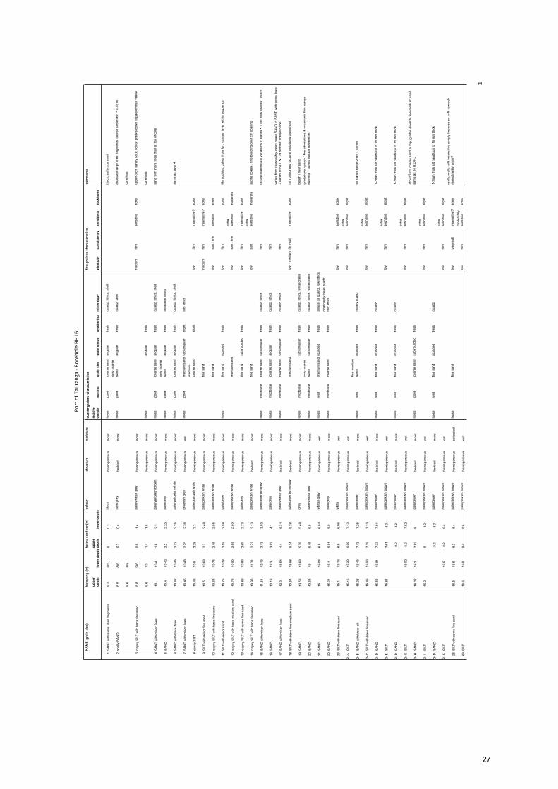
ThecoresfromboreholesBH15-19weretransferredtothecorestorageattheUniversityofWaikato, and subsequently described using standard geotechnical methods andphotographed(AppendixA).Subsamplesof<1gweretakenfromeachunitidentifiedinthecore for particle size analysis by laser diffraction using aMalvernMastersizer. The sub-sampled sediment was not deflocculated with Calgon, and any organics present wereretained.Thesubsampleswerepre-sievedthrougha2mm(2000µm)sievetoremovegravelandpreventblockagesintheMastersizer,andthenthesizedistributionsbetween0.05and3600 µm were measured. The distribution was analysed using the moment method todeterminethesedimenttexturalparameters,andtheproportionsofsand,silt,clayandfines(silt+clayor<62.5µm)weredetermined.Resultsforsamplesthathadgravelremovedpriorto measurement, were adjusted to account for the proportion of gravel in the originalsample.Thesilttoclayboundarywastakentobe2µm.ThedetailedtexturalanalysisresultsarepresentedinAppendixC.The results obtained from the (volume distribution) are not directly comparable to thetextural analysis results reported by OPUS (2019), which were based on wet sieving(suitable for gravel-sand sediment) and hydrometer (suitable for silt-clay sediment)methodsthatprovidemassdistributions.Thisoccursduetothethreetechniquesmeasuringdifferentpropertiesrelatedtosedimenttexture:projectedgrainvolumefortheMastersizer;massproportionforintermediateaxisdiametersforwetsieving;andsedimentdensityandsettlingvelocityforthehydrometermethod.However,althoughtheMastersizerestimatedproportionsoffines(<62.5µm)shouldbereasonablysimilartotheresultsdeterminedbythehydrometermethodbyOPUS.
7
LeapfroggeologicalmodellingsoftwarewasusedtocombinedatafromallboreholesandCPTsites(Figure3)todevelopa3DstratigraphicmodelforsouthernStellaPassage.Thismodelisavailablewithaviewerthatallowsslicestobegeneratedinanyorientation.
Sub-surface facies Sixmain stratigraphic units (facies)were identified from the available data. In order ofincreasingdepthbelowthesurface(increasingage)theyare:
• Blackfinesands;• Greyshellysands;• Darkbrownorganicsilts;• Paleyellowpumiceoussands;• Olive-greensands;and• Palegreyquartzsands.
Almostallsamplesfromthesefaciescontained>5%silt:theexceptionsbeingafewsamplesfromsitesreportedbyOPUS(2019)withintheproposedwharfextension.
Black fine sands
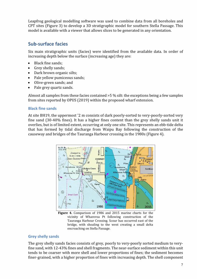
AtsiteBH19,theuppermost˜2mconsistsofdarkpoorly-sortedtovery-poorly-sortedveryfine sand (30-40% fines). Ithasahigher fines content than thegrey shelly sandsunit itoverlies,butisoflimitedextent,occurringatonlyonesite.Thisrepresentsanebb-tidedeltathat has formed by tidal discharge from Waipu Bay following the construction of thecausewayandbridgesoftheTaurangaHarbourcrossinginthe1980s(Figure4).
Figure 4. Comparison of 1986 and 2015 marine charts for the
vicinity of Whareroa Pt following construction of theTaurangaHarbourCrossing.Scourhasoccurredeastofthebridge, with shoaling to the west creating a small deltaencroachingonStellaPassage.
Grey shelly sands
Thegreyshellysandsfaciesconsistsofgrey,poorlytovery-poorlysortedmediumtovery-finesand,with12-43%finesandshellfragments.Thenear-surfacesedimentwithinthisunittendstobecoarserwithmoreshellandlowerproportionsoffines;thesedimentbecomesfiner-grained,withahigherproportionoffineswithincreasingdepth.Theshellcomponent

8
tendstobeconcentratedinshelllaglayers.InCPTlogs,greyshellysandsarecharacterisedbyarelativelyhightipresistance,whichdropssignificantly(byupto8MPa)attheboundarywiththeunderlyingfacies.ThefaciescorrespondstotheCoarseSand(CS)andPumiceousSand(PS)faciesofMacPhersonetal(2017)andUNIT1(Holocenemarinesandandsilt)ofJoratetal(2017).ItThe thickest grey shelly sands unit occurs at BH18 (~7.2 m), BH19 (~3.5 m includingoverlyingblackfinesandunit),andCPT24(~2m).Attheremainingsitesitistypically£1mthick.
This facies started forming between c. 7600 and c. 6800 years BP when sea levelapproximatelyreachedthecurrentelevation.MacPhersonetal (2017) identifiedtheirCSfaciesasashorefacedepositthatformedbeforetheMtMaunganuitomboloclosedofftheharbour fromdirectwaveaction, afterwhich the locally-derivedPS facieswasdepositedwithintheharbour.InthesouthernStellaPassagegreyshellysandappearstoinfillchannelsor valleys in the underlying units,which suggests tidal channel and lower intertidal flatenvironmentscomparabletothepresent-daysituation.However,petrographicanalysistodeterminetherelativeproportionsofCSandPSfacieswithinthegreyshellysandunithasnotbeenundertaken.
Dark brown organic silts
Thedarkbrownorganicsiltsfaciesisdescribedinthecore-logsofOPUS(2019)report,andconsistsoforganic-richsilts,withwoodfragments.ThefacieswasnotanalysedforsedimenttexturebyOPUS,butisexpectedtohaveahighfinescontent.Itisinterpretedasmostlylikelybeinganupperintertidalflatsalt-marshdeposit.Thisfaciesdoesn’tcorrespondtoanyofthespecificfaciesidentifiedbypreviousstudies,butisnotedasoccurringwithinUNIT4(Middlepumiceoussandandsilt)ofJoratetal(2017).Itoccurs in a restricted area, predominantly within the proposed Sulphur Point wharfextension(BH03,BH07,BH09,andBH13)atvariabledepthswithamaximumthicknessof~1.5 m. However, thinner exposures occur along the western margin of the proposeddredged channel (BH12 and BH14). Therefore, it may be exposed by dredging in closeproximitytothenewwharf.
Pale yellow pumiceous sands
ThepaleyellowpumiceoussandscorrespondtotheVolcanicSand(VS)andLithicSilt(LS)faciesofMacPhersonetal(2017),andUNIT2(Upperpumiceoussandandsilt)andUNIT3(Silt-sand-clay)ofJoratetal(2017).Althoughtheseearlierstudiessub-dividedthisfaciesusingavarietyofcriteria,itwasn’tpossibletodosoforthesouthernStellaPassageasthesuccessioninthisareaconsistsoflensoidalorlenticularsub-unitsthathavelimitedarealextent.Thislackofcontinuitymadeitimpossibletocorrelateindividualsub-unitsbetweenboreholesandCPTsites,eventhoseincloseproximity.Texturally the facies ispoorly tovery-poorly sorted,with individual lensesvarying fromvery-finesilttomediumsand,withsomegravels.Thefinescontentvariesfrom18-97%,withno systematic variationwith depth. Although there is a general trend of increasing coneresistancewithdepth,CPTlogsarehighlyvariablethroughthisunit.This facies is interpreted as representing fluvially reworked volcaniclastic sedimentsdepositedinanalluvialfanbyabraidedriversystemduringthelastglacialperiod(20-110thousandyearsago).Thisenvironmentproducesahighlyvariabledepositincludingchannel,overbankflood,andlakesediments,whichcanincludeswampdepositsandpaleosols.
9
Basedonpreviousdredgingactivities innorthernStellaPassageandpipelayingnear therailway bridge, it is likely that iron-oxide hardpans (paleosols) and buried logs will beencounteredwithin the pale yellowpumiceous sands. Previous dredging campaigns thatencountered hardpans used bucket excavators as the cutter heads from cutter-suctiondredges had difficulty breaking through the hardpan. This may be necessary for theproposedsouthernStellaPassagedredging.Unfortunately,itisnotpossibletodeterminethelocation and extent of hardpans, or locations of buried logs, within this unit. If ourinterpretation of the depositional environment is correct, hardpans are more likely insouthernStellaPassagethanwithintheshippingchannelsalreadyexcavated.
Olive-green sands
Theolive-greensandsfaciesislimitedinextentandappearstooccurwithinchannelsinthelowestfaciesunit.ThethickestsequencewasfoundatBH19,where~1.5mwasrecoveredfromthebaseoftheborehole(>22.5mbelowriglevel).Theunitfinesupwards,withthelowestsamplescontaining7-11%fines,whiletheuppermostsamplecontained27%fines.Therearesomeshell fragmentspresent.Thisunit is interpretedasgrading fromshallowmarine (shoreface) at the base to intertidal flat and possibly terrestrial dunes, andcorrespondstoaprevioussea levelhigh-stand,probably fromtheEemianInterglacialca.120thousandyearsago.ThedepthatwhichthisunitoccursindicatesthesouthernStellaPassagehassubsidedsincethepreviousinterglacial,aspreviousPleistoceneinterglacialsealevel high-stands are believed to have been at least at the current interglacial elevation(Pedojaetal,2011).Thisfaciesshouldn’tbeencounteredduringtheproposeddredging.Itissimilartomodernmarinesands,buthasundergonesignificantweathering,resultinginthelossofmostshellmaterial, an increase in fines content, and olive-green colours associated with reducingconditions.
Pale grey quartz sands
The pale grey quartz sands predominantly consist ofmoderately-sorted to very poorly-sortedmediumtoveryfinesand.Therearesomesub-unitsthatconsistofverypoorly-sortedcoarsetoveryfinesilt.Sandysub-unitshavefinescontentsfrom6-53%,withtheproportionoffineswithintheentireunitincreasingasmeangrainsizedecreases:mediumsand6-11%;finesand9-37%;veryfinesand42-53%;coarsesilt68%;finesilt87%;andveryfinesilt95%.ThisfacieswasidentifiedinCPTlogsbyasharpincreaseinrelativedensitycomparedtotheoverlyingPleistocenealluvialfanunit.TherelativedensitytracesarenotincludedinthisreportastheygenerallymatchtheconeresistancetracesthatareinAppendixB.InmostoftheCPTlogs,theconeresistanceincreasesfrom4-8MPainthepaleyellowpumiceoussandsto8-20MPainthepalegreyquartzsands.The exceptions are CPT21 and CPT28. CPT21 was located close to BH15, where theboundarybetweenthetwofacieswasawhitesiltyclayassociatedwithaconeresistanceincrease from2-4Ma to 4-6MPa. CPT28 is not close to a borehole, but the interpretedstratigraphyismostsimilartoBH19.ThetransitionatthebaseofthepaleyellowpumiceoussandsfaciesinCPT29ismarkedbyadecreaseinconeresistancefrom10-11MPato5-6MPa,before increasing to 20MPawith depth. The decrease in cone resistance appears to beassociatedwiththeuppermostsectionoftheolive-greensandsfacies,whilethesubsequentincreaseinconeresistancecorrespondstothelowerolive-greensandsandunderlyingpalegreyquartzsands.

10
Thepalegreyquartzsandsandolive-greensandscorrespondtoUNIT4(Middlepumiceoussandandsilt)ofJoratetal(2017)andwasnotexposedintheshallowcoresofMacPhersonetal(2017).Thisfaciesisinterpretedasbeingafloodplainenvironment,probablysimilartotheyoungerpalepumiceoussandsfacies.
Minor units
There are also some subordinate stratigraphic units with limited distribution withinsouthernStellaPassage,whichwerenotdefinedasfacies.Theyaresummarisedbelow.FragmentsofbrokenglasswereobservedwithinthedeeperHolocenesandswithinBH17.Thissiteislocatedwithinahistoricalconsenteddumpextractionsite(Figure5).ThesitewasusedtostoremaintenancedredgingspoilpriortotransfertolandonSulphurPoint.Theseabed within this extraction site has been repeatedly excavated and refilled, and theuppermoststrataareseverelydisrupted.Thesedimentatthetopofcorecomprisedpoorlytovery-poorlysortedfinetovery-finesand,withsomethinshell-hashgravellayers,andafinescontentof20-43%.
Figure 5. Location of excavated pit in seabed used as temporary storage of clean spoil from
maintenancedredgingpriortotransfertostoragepilesonSulphurPoint.
SiteBH15contains~2mthickvolcanictephra(andpossiblyignimbrites),co-ignimbriteashandtephrasequences(appendixA).Apartfromathinpoorly-sortedmedium-coarsesandignimbrite(14%fines),theunitisdominatedbyverypoorly-sortedfinetocoarsesilts(64-90%fines).Athinnertephra/ignimbrite(~40cm)occursinBH17,comprisingmostlyofasandyignimbritecomponent,whichmaybeacorrelativeofthesequenceatBH15.Thisunitcouldnotbeidentifiedattheremainingsites.
Athin(3-4cm)organic-rich layeroccursnearthebaseof theHolocenesandunitwithinBH18.Thisisinterpretedasaswamporsaltmarshdeposit.Itwasnotidentifiedatanyothersite.Thisunitwasanalysedasaverypoorly-sortedvery-finesand,with46%fines.

11
Leapfrog model ThesouthernStellaPassagecontainscorrelativesofthestratigraphicsuccessionpreviouslyencounteredduring capitaldredgingprogrammes innorthernStellaPassage,MaunganuiRoadsandCutterChannel.However,withincreasingdistancefromtheharbourchannelthestratigraphic units are increasingly influenced by terrestrial sedimentary input and lessinfluencedbymarinesedimentaryinput.Thisisassociatedwithanincreasingfinescontentwithinthesediment.Tovisualisethedistributionoftheunitsdiscussedabove,a3DsubsurfaceLeapfrogmodelwasconstructedusingalltheavailabledatafromearlierinvestigationsofStellaPassage(deLangeetal,2014;Upiap,2015;Joratetal,2017),OPUS(2019)andthisreport.Themodelshows our interpretation of the sub-surface stratigraphy. This model and viewer areavailableonrequest to thePortofTaurangaLtd.Toassistwiththe followingdiscussion,severaltransectswereusedtopreparecross-sectionsofstratigraphicunitsandestimatedfinescontent(Figure6).
Figure6.LocationsoftransectsthroughtheLeapfrogmodel
relative to Stella Passage and the area of proposedcapitaldredging.
Inordertoutilisethestratigraphicdatafromtheshortcoresobtainedpriortothe2015-2016capitaldredgingcampaign, theLeapfrogmodelusesthepre-2015bathymetry.Thisdoesn’t impact the sediment volumes within the proposed southwards extension of theshippingchannel,asthecurrentbathymetryisverysimilar.Onlyminorscourandaccretionhasoccurredsincethecapitaldredging.AninitialmodelwasdevelopedusingasimplifiedstratigraphytohelpinterprettheboreholeandCPTdata.ThismodelextendedwellbeyondthemarginsasshownbythetransectsinFigure6.Thesimplifiedstratigraphicunits(Figure7)were:
• Holocenesandconsistingoftheblackfinesandandgreyshellysandfacies;• Pleistoceneorganicsiltconsistingofthedark-brownorganicsiltfacies;• Pleistocenealluvialfanconsistingofthepaleyellowpumiceoussandfacies;and• Pleistoceneterrestrialandshallowmarinesandconsistingoftheolive-greensandsand
palegreyquartzsandsfacies

12
Thismodel was then refined using the six main facies units and the boundaries of theproposedcapitaldredging(Figure6).TomaximisetheavailableinformationbyincludingtheresultsreportedbyOPUS(2019),themodelboundarieswereextendedbeyondtheareamarked in Figure 6, particularly on thewesternmargin. The refinedmodelwasused toproduceestimatesofsurfaceareasandvolumes,andisavailableforviewingandanalysisfromthePortofTauranga.
Figure7.East-westslicesthroughtheLeapfrogsubsurfacestratigraphicmodel,fromtheexistingshipping
channelinthenorth(top)tothemarinainthesouth(bottom),showingthedistributionofthe4mainunitsdiscussedinthetext.Theproposed14.5mchanneldepthismarked.
Overall,thehighestvolumeofsiltandclayoccurswithinPleistocenealluvialfanunit(paleyellowpumiceoussands)duetothecombinationof terrestrialsediment input,aswellasweatheringandassociatedsoilformationduringthelastglacialperiod.Duetothelaterallydiscontinuousnatureofsub-unitsthedepositandlimitedboreholeandCPTdata,itisnotpossibletodefinethe3Ddistributionofsiltsandclayswithinthisunit.Althoughdeposits

13
associatedwithvolcaniceruptions(ignimbritesandtephras)generallyformacontinuouslayerwhendeposited,itisclearthatthesehavebeenlargelyreworkedwithinthealluvialfandepositsandnowhavepatchydistributions.Therefore,thisunithasbeentreatedasasingleheterogenoussuccessionintheLeapfrogmodel.Thedark-brownorganicsiltunithasthehighestproportionoffineswithinrelativelythicklayers(1-2m),aswellasasignificantproportionofwoodydebris.Theboreholescontainingthisfacieswerelocatedclosetotheeasternboundaryof theLeapfrogmodel,whichmade itdifficult todetermine the three-dimensionalextentofthefacies.Therefore,themodelwasadjustedtomaximisetheextentofthefaciestoprovideaworst-caseestimateofthevolume(Table1).However,mostofthisunitliesundertheproposedwharf,whichmayaffectwharfconstruction,butreducesthelikelyimpactondredging.
Figure8.North-southslicesthroughtheLeapfrogsubsurfacestratigraphicmodel,fromtheMtMaunganui
wharvesintheeast(top)totheSulphurPtwharvesonthewest(bottom),showingthedistributionofthe4mainunitsdiscussedinthetext.Theproposed14.5mchanneldepthismarked.
Figures7&8showstratigraphicslicesthoughthesubsurfacemodelasindicatedinFigure6.ThesesliceshighlighttheincreasingthicknessofPleistocenealluvialfansedimentsanddecreasing thicknessofHolocene sandwithdistance southwards throughStellaPassage.Depending on the final design depth, and amount of over-deepening that occurs duringdredging, the Pleistocene terrestrial andmarine sand should not be encountered during
14
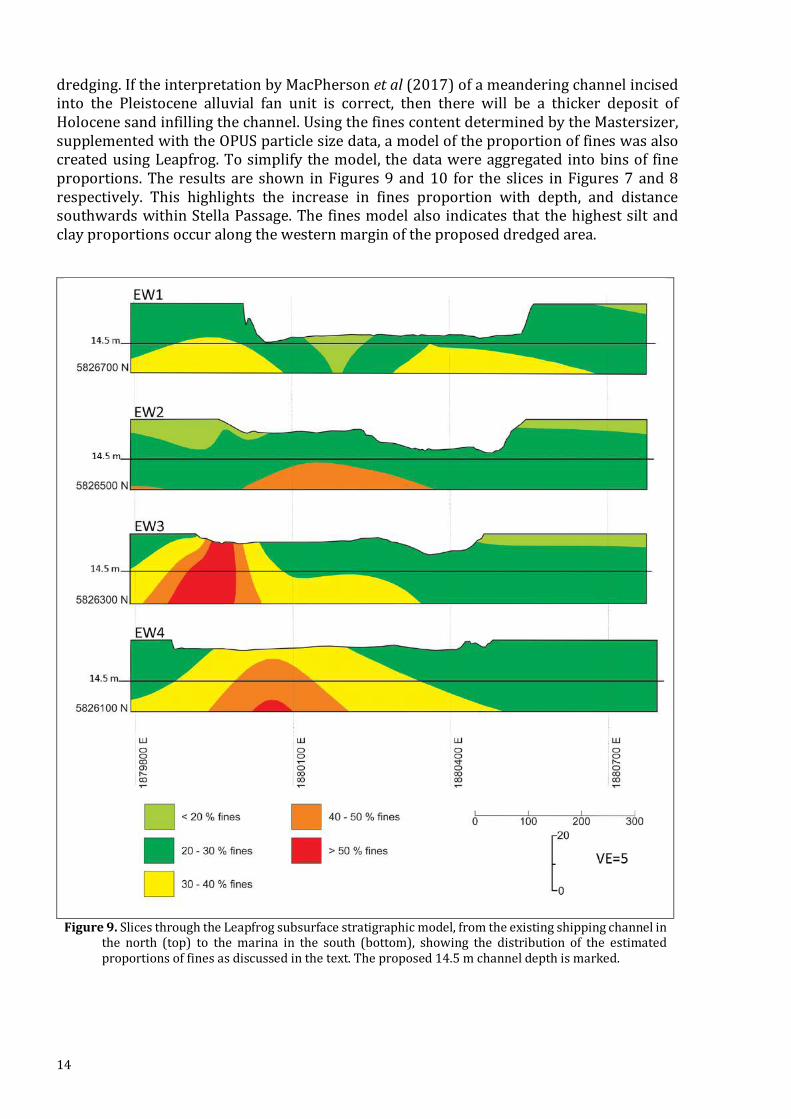
dredging.IftheinterpretationbyMacPhersonetal(2017)ofameanderingchannelincisedinto the Pleistocene alluvial fan unit is correct, then there will be a thicker deposit ofHolocenesandinfillingthechannel.UsingthefinescontentdeterminedbytheMastersizer,supplementedwiththeOPUSparticlesizedata,amodeloftheproportionoffineswasalsocreatedusingLeapfrog.Tosimplify themodel, thedatawereaggregated intobinsof fineproportions.The results are shown inFigures9and10 for the slices inFigures7and8respectively. This highlights the increase in fines proportion with depth, and distancesouthwardswithinStellaPassage.The finesmodelalsoindicates that thehighestsiltandclayproportionsoccuralongthewesternmarginoftheproposeddredgedarea.
Figure9.SlicesthroughtheLeapfrogsubsurfacestratigraphicmodel,fromtheexistingshippingchannelin
the north (top) to themarina in the south (bottom), showing the distribution of the estimatedproportionsoffinesasdiscussedinthetext.Theproposed14.5mchanneldepthismarked.

15
Figure10.SlicesthroughtheLeapfrogsubsurfacestratigraphicmodel,fromtheMtMaunganuiwharvesin
the east (top) to the Sulphur Ptwharves on thewest (bottom), showing the distribution of theestimatedproportionsoffinesasdiscussedinthetext.Theproposed14.5mchanneldepthismarked.
Theuppersurfaceareaandvolumesofeachmainfacies(excepttheolive-greensands)withintheproposeddredgedareawereestimatedbyLeapfrog.Thevolumesofsedimentwithinspecificrangesoffinescontentwerealsoestimated.TheseestimatesaresummarisedinTable1.
Conclusion ItisevidentfromFigures7–10andTable1thatmost(>75%)ofthesedimenttobedredgedislikelytoexceedthe25%thresholdrequiringdisposalatoffshoresiteH2.Otherwise,therearenocharacteristicsthatmakethesedimentunsuitablefordisposalatoffshoresiteH2.Theupper grey shelly sands alsomeet the requirements for disposal site H1. No facieswasidentifiedthatissuitableforshallow-waterdisposal.

16
Table1.Summaryofestimatedareasfortheuppersurfaceandvolumesforthemain
facieswithindredgedareaaboveadepthof16m(channeldepthof14.5mplus1.5mover-deepeningallowance).Theolive-greensandsfacieswasomittedduetoits’veryimitedextent.Estimatedvolumesforspecifiedrangesoffinescontentarealsosummarised.
Facies Area(m2) Volume(m3)Black fine sands 5,581 4,868
Grey shelly sands 371,450 693,900
Dark brown organic silts 72,625 126,660
Pale yellow pumiceous sands 310,000 715,910
Pale grey quartz sands 352,640 411,910
Finesbins <10% 12,595
10-20% 165,950
20-30% 709,820
30-40% 476,960
40-50% 388,080
50-75% 198,780
>75% 1,072
References Davis,R.A.,andHealy,T.R.,1993.Holocenecoastaldepositionalsequencesonatectonically
activesetting:southeasternTaurangaHarbour,NewZealand.SedimentaryGeology84:57-69.
deLange,W.P.,Moon,V.G.,andFox,B.R.S.,2014.DistributionofsiltysedimentsintheshallowsubsurfaceoftheshippingchannelsofTaurangaHarbour.EnvironmentalResearchInstituteReportNo43.ClientreportpreparedforPortofTauranga.EnvironmentalResearchInstitute,FacultyofScienceandEngineering,TheUniversityofWaikato,Hamilton.76pp.
Jorat,M.E.,Moon,V.G.,Hepp,D.A.,Kreiter,S.,deLange,W.P.,Feldmann,S.,andMörz,T.2017.SubseafloorInvestigationofSedimentsatSouthernTaurangaHarbour,NewZealand,beforeCapitalDredging.JournalofCoastalResearch,33(2):227-242.
MacPherson,D.,Fox,B.R.S.,anddeLange,W.P.,2017."HoloceneevolutionofthesouthernTaurangaHarbour"NewZealandJournalofGeologyandGeophysics60(4):392-409.
Moon,V.G.,deLange,W.P.,Jorat,M.E.,Christophers,A.,andMoerz,T.,2013.Sub-surfacestratigraphyofStellaPassage,TaurangaHarbour.EnvironmentalResearchInstituteReportNo28.ClientreportpreparedforPortofTauranga.EnvironmentalResearchInstitute,FacultyofScienceandEngineering,TheUniversityofWaikato,Hamilton.23pp.
OPUS,2019.SulphurPointSouthernWharfExtension–PortofTauranga:Geotechnicalfactualreport.359pp.

17
Pedoja,K.,Husson,ZL.,Regard,V.,Cobbold,P.R.,Ostanciaux,E.,Johnson,M.E.,Kershaw,S.,Saillard,M.,JosephMartinod,J.,Furgerot,L.,Weill,P.,andDelcaillau,B.,2011.Relativesea-levelfallsincethelastinterglacialstage:Arecoastsupliftingworldwide?Earth-ScienceReviews108:1–15.
Upiap,J.2015.Specialtopicresearchreport.Hamilton(NZ):SchoolofScience,UniversityofWaikato.

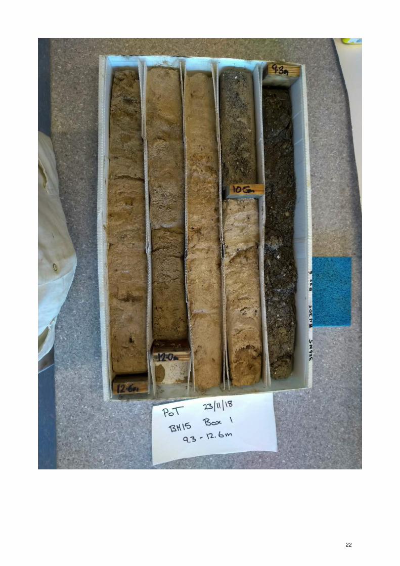
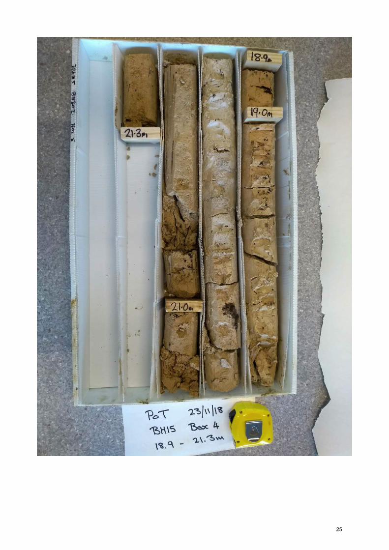
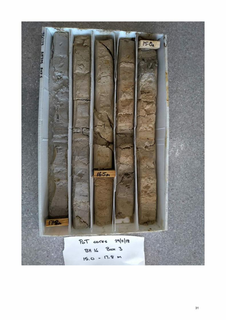
Appendix A – Core descriptions and images The following pages consist of bore logs and photographs for boreholes BH15 to BH19collected from southern Stella Passage (Figure 3). These data supplement the resultspresentedbyOPUS(2019)
18

19

PortofT
auranga-B
oreh
oleBH
15
1
NA
ME
(gra
in s
ize)
colo
urst
ruct
ure
moi
stur
eco
mm
ents
uppe
r de
pth
low
er d
epth
uppe
r de
pth
low
er d
epth
rela
tive
dens
ityso
rtin
ggr
ain
size
grai
n sh
ape
wea
ther
ing
min
eral
ogy
plas
ticity
cons
iste
ncy
sens
itivi
tyst
icki
ness
1S
AN
D w
ith a
bund
ant s
hell
fragm
ents
9.3
9.8
00.
5da
rk g
rey
hom
ogen
eous
wet
loos
em
oder
ate
med
ium
san
dan
gula
rfre
shqu
artz
, dar
k lit
hics
, she
ll
2S
AN
D w
ith a
bund
ant s
hell
fragm
ents
9.8
10.5
0.5
1.2
light
gre
yho
mog
eneo
usw
etlo
ose
poor
coar
se s
and
angu
lar
fresh
quar
tz, d
ark
lithi
cs, s
hell,
m
ica?
3sa
ndy
SIL
T10
.510
.61.
21.
3pa
le y
ello
who
mog
eneo
usw
etpo
orfin
e sa
ndsu
brou
nded
fresh
dark
lith
ics
slig
htly
soft
sens
itive
non-
stic
ky
4S
AN
D10
.610
.71.
31.
4br
own
hom
ogen
eous
wet
poor
coar
se s
and
fresh
quar
tz,d
ark
lithi
cs
5sa
ndy
SIL
T10
.710
.81.
41.
5pa
le y
ello
who
mog
eneo
usw
etpo
orfin
e sa
ndro
unde
dfre
shqu
artz
, dar
k lit
hics
slig
htly
soft
sens
itive
non-
stic
ky
6S
AN
D10
.810
.85
1.5
1.55
brow
nho
mog
eneo
usw
etpo
orco
arse
san
dfre
shqu
artz
, dar
k lit
hics
7sa
ndy
SIL
T10
.85
11.0
51.
551.
75pa
le b
row
nho
mog
eneo
usw
etpo
orfin
e sa
ndsu
brou
nded
fresh
quar
tz, d
ark
lithi
cssl
ight
lyso
ftse
nsiti
veno
n-st
icky
8S
AN
D11
.05
11.5
51.
752.
25pa
le y
ello
w to
ligh
t gre
yho
mog
eneo
usw
etm
oder
ate
fine
sand
suba
ngul
arfre
shqu
artz
, dar
k lit
hics
none
soft
sens
itive
non-
stic
ky
9S
AN
D11
.55
12.1
2.25
2.8
light
yel
low
hom
ogen
eous
wet
loos
epo
orco
arse
san
dan
gula
rfre
shqu
artz
, fel
dspa
r, da
rk li
thic
s (>
50 %
)
10S
AN
D12
.112
.22
2.8
2.92
brow
n to
ligh
t yel
low
hom
ogen
eous
wet
loos
em
oder
ate
coar
se s
and
angu
lar
fresh
quar
tz, f
elds
par,
dark
lith
ics
occa
sion
al M
n to
10
mm
11S
AN
D12
.22
12.4
52.
923.
15
yello
wis
h br
own
to li
ght
yello
who
mog
eneo
usw
etlo
ose
poor
med
ium
san
dan
gula
rsl
ight
stai
ned
quar
tz, f
elds
par,
dark
lith
ics
12S
AN
D12
.45
12.6
3.15
3.3
brow
n to
ligh
t yel
low
hom
ogen
eous
wet
loos
em
oder
ate
coar
se s
and
angu
lar
slig
htst
aine
d qu
artz
, dar
k lit
hics
(4
0 %
)
13sa
ndy
SIL
T12
.612
.77
3.3
3.47
pale
yel
low
hom
ogen
eous
wet
mod
erat
ew
ell
fine
sand
roun
ded
fresh
quar
tz, m
inor
dar
k lit
hics
low
soft
sens
itive
non-
stic
ky
14S
AN
D12
.77
12.8
93.
473.
59ye
llow
ish
brow
nbe
dded
wet
loos
em
oder
ate
med
ium
san
dan
gula
rfre
shqu
artz
, dar
k lit
hics
(7-1
0 %
)5-
10 m
m la
yers
dar
k/pa
le
15S
AN
D w
ith s
ome
silt
12.8
913
.53.
594.
2pa
le y
ello
who
mog
eneo
ussa
tura
ted
loos
em
oder
ate
fine
sand
angu
lar
fresh
quar
tz, d
ark
lithi
csve
ry s
oft
16S
AN
D w
ith m
inor
silt
13.5
13.7
4.2
4.4
dull
yello
wis
h or
ange
hom
ogen
eous
wet
loos
ew
ell
coar
se s
and
angu
lar
fresh
dark
lith
ics
soft
17S
AN
D w
ith s
ome
silt
13.7
14.1
94.
44.
89br
ight
bro
wn
hom
ogen
eous
wet
loos
em
oder
ate
coar
se s
and
suba
ngul
arfre
shda
rk li
thic
sso
ft
18sa
ndy
SIL
T14
.19
15.2
4.89
5.9
pale
yel
low
hom
ogen
eous
wet
wel
lfin
e sa
ndan
gula
rfre
shsl
ight
lyfir
mse
nsiti
veno
n-st
icky
19S
AN
D15
.215
.45.
96.
1pa
le b
row
n to
ligh
t yel
low
hom
ogen
eous
wet
loos
e - m
od.
poor
coar
se s
and
suba
ngul
arfre
shqu
artz
, dar
k lit
hics
firm
20S
ILT
with
som
e cl
ay a
nd tr
ace
sand
15.4
15.4
56.
16.
15pa
le y
ello
wfis
sure
dw
etlo
w-m
oder
ate
firm
sens
itive
non-
stic
kyM
n
21S
AN
D w
ith m
inor
silt
15.4
515
.54
6.15
6.24
pale
yel
low
hom
ogen
eous
wet
loos
e - m
od.
wel
lm
ediu
m s
and
subr
ound
edfre
shqu
artz
, dar
k lit
hics
firm
22S
ILT
with
trac
e fin
e sa
nd15
.54
15.5
76.
246.
27lig
ht p
inki
sh w
hite
hom
ogen
eous
wet
low
firm
mod
erat
eno
n-st
icky
23cl
ayey
SIL
T w
ith m
inor
fine
san
d15
.57
16.2
6.27
6.9
pale
bro
wni
sh g
rey
hom
ogen
eous
wet
low
very
sof
tse
nsiti
vesl
ight
ly
24S
AN
D w
ith m
inor
silt
16.2
16.2
76.
96.
97pa
le b
row
nho
mog
eneo
usw
etlo
ose
- mod
.po
orco
arse
san
dsu
bang
ular
fresh
quar
tz, d
ark
lithi
cs
25C
LAY
with
trac
e fin
e sa
nd16
.27
17.2
56.
977.
95lig
ht p
inki
sh w
hite
hom
ogen
eous
wet
high
soft
- firm
sens
itive
?m
oder
ate
26S
AN
D17
.25
17.3
37.
958.
03pa
le b
row
nish
gre
ybe
dded
wet
loos
epo
orco
arse
san
dsu
brou
nded
fresh
quar
tz, d
ark
lithi
csth
in b
ands
med
ium
SA
ND
, brig
ht o
rang
e, ~
2 m
m th
ick
spac
ed 2
0 m
m; c
ore
disc
ed o
n ba
nds
27C
LAY
17.3
317
.43
8.03
8.13
light
pin
kish
whi
teho
mog
eneo
usw
ethi
ghve
ry s
oft
sens
itive
mod
erat
e17
.36
m: t
hin
fine
SA
ND
ban
d, b
right
ora
nge,
2m
m th
ick
28S
AN
D w
ith tr
ace
clay
17.4
317
.46
8.13
8.16
pale
bro
wni
sh g
rey
hom
ogen
eous
wet
loos
em
oder
ate
coar
se s
and
suba
ngul
arfre
shqu
artz
, dar
k lit
hics
(> 3
0 %
)
29si
lty S
AN
D17
.46
17.7
8.16
8.4
pale
yel
low
ish
whi
te to
pa
le p
inki
sh w
hite
hom
ogen
eous
wet
loos
epo
orco
arse
san
dsu
brou
nded
fresh
quar
tz (d
omin
ant)
low
-mod
erat
eso
ft - f
irmin
sens
itive
mod
erat
e
30sa
ndy
SIL
T17
.717
.93
8.4
8.63
pale
yel
low
hom
ogen
eous
moi
stlo
ose
- mod
.w
ell
med
ium
san
dsu
brou
nded
fresh
quar
tzm
oder
ate
firm
inse
nsiti
veno
n-st
icky
31cl
ayey
SIL
T w
ith m
inor
san
d17
.93
17.9
58.
638.
65pa
le y
ello
who
mog
eneo
usw
etqu
artz
, som
e da
rk li
thic
slo
wve
ry s
oft
sens
itive
mod
erat
e
32S
AN
D w
ith s
ome
silt
/ cla
y17
.95
18.2
8.65
8.9
pale
yel
low
hom
ogen
eous
wet
loos
epo
orco
arse
san
dan
gula
rfre
shqu
artz
, dar
k cr
ysta
ls?
som
e sl
ight
text
ural
var
iatio
ns -
sand
con
tent
incr
ease
s an
d fin
es to
ba
se, s
ortin
g in
crea
ses
33cl
ayey
SIL
T18
.219
.48.
910
.1pa
le p
inki
sh o
rang
ebe
dded
wet
wel
lm
ediu
m s
and
angu
lar
fresh
low
very
sof
tse
nsiti
vesl
ight
lyba
nds
with
wel
l-sor
ted
med
um s
and
rang
ing
from
trac
e to
dom
inan
t up
to 7
cm
thic
k sp
aced
15-
20 c
m, g
rada
tiona
l bou
ndar
ies
34si
lty C
LAY
19.4
19.7
10.1
10.4
whi
teho
mog
eneo
usw
etlo
wso
ft - f
irmex
trasl
ight
ly
35S
AN
D19
.719
.810
.410
.5pa
le g
reyi
sh w
hite
hom
ogen
eous
wet
loos
e - m
od.
wel
lco
arse
san
dan
gula
rfre
shqu
artz
, dar
k lit
hics
?
36cl
ayey
SIL
T19
.819
.86
10.5
10.5
6w
hite
hom
ogen
eous
wet
mod
erat
efir
mm
oder
atel
ysl
ight
y
37S
ILT
with
som
e cl
ay a
nd tr
ace
sand
19.8
620
.410
.56
11.1
light
pin
kish
whi
teho
mog
eneo
usm
oist
low
firm
- st
iffse
nsiiv
esl
ight
ly
fine-
grai
ned
char
acte
rist
ics
coar
se-g
rain
ed c
hara
cter
istic
sbe
low
rig
(m)
belo
w s
eaflo
or (m
)
20

PortofT
auranga-B
oreh
oleBH
15
2
NA
ME
(gra
in s
ize)
colo
urst
ruct
ure
moi
stur
eco
mm
ents
uppe
r de
pth
low
er d
epth
uppe
r de
pth
low
er d
epth
rela
tive
dens
ityso
rtin
ggr
ain
size
grai
n sh
ape
wea
ther
ing
min
eral
ogy
plas
ticity
cons
iste
ncy
sens
itivi
tyst
icki
ness
fine-
grai
ned
char
acte
rist
ics
coar
se-g
rain
ed c
hara
cter
istic
sbe
low
rig
(m)
belo
w s
eaflo
or (m
)
38si
lty S
AN
D20
.121
10.8
11.7
pale
pin
kish
bro
wn
hom
ogen
eous
moi
stm
oder
ate
coar
se s
and
suba
ngul
arfre
shqu
artz
mod
erat
est
iffno
n-st
icky
39si
lty S
AN
D21
21.3
11.7
12pa
le p
inki
sh b
row
nho
mog
eneo
usm
oist
mod
. - ti
ght
wel
lco
arse
san
dsu
brou
nded
fresh
feld
spar
?fir
m
21
22

23

24
25

26
PortofT
auranga-B
oreh
oleBH
16
1
NA
ME
(gra
in s
ize)
colo
urst
ruct
ure
moi
stur
eco
mm
ents
uppe
r de
pth
low
er d
epth
uppe
r de
pth
low
er d
epth
rela
tive
dens
ityso
rtin
ggr
ain
size
grai
n sh
ape
wea
ther
ing
min
eral
ogy
plas
ticity
cons
iste
ncy
sens
itivi
tyst
icki
ness
1S
AN
D w
ith s
ome
shel
l fra
gmen
ts8.
28.
50
0.3
blac
kho
mog
eneo
usm
oist
loos
epo
orco
arse
san
dan
gula
rfre
shqu
artz
, lith
ics,
she
llbl
ack,
sul
furo
us s
mel
l
2sh
elly
SA
ND
8.5
8.6
0.3
0.4
dark
gre
ybe
dded
moi
stlo
ose
poor
very
coa
rse
sand
angu
lar
fresh
quar
tz, s
hell
abun
dant
larg
e sh
ell f
ragm
ents
, coa
rse
shel
l has
h ~
8.55
m
8.6
8.8
core
loss
3cl
ayey
SIL
T w
ith tr
ace
fine
sand
8.8
9.6
0.6
1.4
pale
whi
tish
grey
hom
ogen
eous
moi
stm
ediu
mfir
mse
nsiti
veno
neup
per 3
cm
san
dy S
ILT;
col
our g
rade
s do
wn
to p
ale
whi
tish
yello
w
9.6
101.
41.
8ho
mog
eneo
usm
oist
loos
ean
gula
rfre
shco
re lo
ss
4S
AN
D w
ith m
inor
fine
s10
10.4
1.8
2.2
pale
yel
low
ish
brow
nho
mog
eneo
usm
oist
loos
epo
orco
arse
san
dan
gula
rfre
shqu
artz
, lith
ics,
she
llsa
nd w
ith m
ore
fines
than
at t
op o
f cor
e
5S
AN
D10
.410
.42
2.2
2.22
pale
gre
yho
mog
eneo
usm
oist
loos
epo
orve
ry c
oars
e sa
ndan
gula
rfre
shab
unda
nt li
thic
s
6S
AN
D w
ith tr
ace
fines
10.4
210
.45
2.22
2.25
pale
yel
low
ish
whi
teho
mog
eneo
usm
oist
loos
epo
orco
arse
san
dan
gula
rfre
shqu
artz
, lith
ics,
she
llsa
me
as la
yer 4
7S
AN
D w
ith m
inor
fine
s10
.45
10.4
82.
252.
28gr
eeni
sh g
rey
hom
ogen
eous
wet
loos
epo
orm
ediu
m s
and
sub-
angu
lar
slig
htlo
ts li
thic
s
8sa
ndy
SIL
T10
.48
10.5
2.28
2.3
pale
ora
ngis
h w
hite
hom
ogen
eous
moi
stm
ediu
m-
coar
se s
and
slig
htlo
wfir
min
sens
itive
?no
ne
9S
ILT
with
min
or fi
ne s
and
10.5
10.6
82.
32.
48pa
le p
inki
sh w
hite
hom
ogen
eous
moi
stfin
e sa
ndm
ediu
mfir
min
sens
itive
?no
ne
10cl
ayey
SIL
T w
ith tr
ace
fine
sand
10.6
810
.75
2.48
2.55
pale
pin
kish
whi
teho
mog
eneo
usm
oist
fine
sand
low
soft
- firm
sens
itive
none
11S
ILT
with
min
or s
and
10.7
510
.78
2.55
2.58
pale
bro
wn
hom
ogen
eous
moi
stlo
ose
fine
sand
roun
ded
fresh
low
firm
none
Mn
nodu
les;
col
our f
rom
Mn;
coa
rser
laye
r with
in s
eque
nce
12cl
ayey
SIL
T w
ith tr
ace
med
ium
san
d10
.78
10.8
92.
582.
69pa
le p
inki
sh w
hite
hom
ogen
eous
moi
stm
ediu
m s
and
low
soft
- firm
extra
se
nsiti
vem
oder
ate
13cl
ayey
SIL
T w
ith s
ome
fine
sand
10.8
910
.93
2.69
2.73
pale
gre
yho
mog
eneo
usm
oist
fine
sand
sub-
roun
ded
fresh
low
firm
inse
nsiti
veno
ne
14cl
ayey
SIL
T w
ith tr
ace
fine
sand
10.9
311
.33
2.73
3.13
pale
pin
kish
whi
tebe
dded
moi
stfin
e sa
ndlo
wso
ftex
tra
sens
itive
mod
erat
esu
btle
coa
rse
/ fin
e be
ddin
g ov
er c
m s
paci
ng
15S
AN
D w
ith m
inor
fine
s11
.33
12.1
33.
133.
93pa
le b
row
nish
gre
yho
mog
eneo
usm
oist
loos
em
oder
ate
coar
se s
and
sub-
angu
lar
fresh
quar
tz, l
ithic
sfir
moc
casi
onal
text
ural
var
iatio
ns in
ban
ds <
1 c
m th
ick
spac
ed 1
0s c
m
16S
AN
D12
.13
12.3
3.93
4.1
pale
gre
yho
mog
eneo
usm
oist
loos
em
oder
ate
coar
se s
and
angu
lar
fresh
quar
tz, l
ithic
sfir
m
17S
AN
D w
ith m
inor
fine
s12
.313
.54
4.1
5.34
pale
whi
tish
grey
bedd
edm
oist
loos
em
oder
ate
coar
se s
and
sub-
angu
lar
fresh
quar
tz, l
ithic
sfir
mva
ries
from
reas
onab
ly c
lean
coa
se S
AN
D to
SA
ND
with
som
e fin
es;
2 ba
nds
of S
ILT
& 1
of r
eddi
sh o
rang
e S
AN
D
18S
ILT
with
trac
e fin
e-m
ediu
m s
and
13.5
413
.58
5.34
5.38
pale
bro
wni
sh y
ello
wbe
dded
moi
stm
ediu
m s
and
low
- m
ediu
mfir
m-s
tiff
inse
nsiti
veno
neth
in c
olou
r and
text
ural
var
iatio
ns th
roug
hout
19S
AN
D13
.58
13.6
85.
385.
48gr
eyho
mog
eneo
usm
oist
loos
em
oder
ate
sub-
angu
lar
fresh
quar
tz, l
ithic
s, w
hite
gra
ins
beac
h / r
iver
san
d
20S
AN
D13
.68
155.
486.
8pa
le w
hitis
h gr
eyho
mog
eneo
usm
oist
loos
em
oder
ate
very
coa
rse
sand
sub-
angu
lar
fresh
quar
tz, l
ithic
s, w
hite
gra
ins
grad
atio
nal c
oars
e / f
ine
alte
rnat
ions
& o
ccas
iona
l thi
n or
ange
st
aini
ng: 7
ban
ds te
xtur
al d
iffer
ence
s
21S
AN
D15
15.0
46.
86.
84w
hitis
h gr
eyho
mog
eneo
usw
etlo
ose
wel
lm
ediu
m s
and
roun
ded
fresh
alm
ost a
ll qu
artz
, few
lith
ics
22S
AN
D15
.04
15.1
6.84
6.9
pale
gre
yho
mog
eneo
usm
oist
loos
em
oder
ate
coar
se s
and
fresh
dom
inan
tly c
lean
qua
rtz,
few
lith
ics
23S
ILT
with
trac
e fin
e sa
nd15
.115
.16
6.9
6.96
whi
teho
mog
eneo
usw
etlo
wfir
mse
nsiti
veno
ne
24A
SIL
T15
.16
15.3
36.
967.
13pa
le p
inki
sh b
row
nho
mog
eneo
usw
etlo
wfir
mex
tra
sesn
itive
slig
ht
24B
SA
ND
with
trac
e si
lt15
.33
15.4
57.
137.
25pa
le b
row
nbe
dded
moi
stlo
ose
wel
lfin
e-m
ediu
m
sand
roun
ded
fresh
mai
nly
quar
tzsi
lt ba
nds
rang
e 2m
m -
10 m
m
24C
SIL
T w
ith tr
ace
fine
sand
15.4
515
.53
7.25
7.33
pale
pin
kish
bro
wn
hom
ogen
eous
wet
low
firm
extra
se
sniti
vesl
ight
24D
SA
ND
15.5
315
.81
7.33
7.61
pale
bro
wn
bedd
edm
oist
loos
ew
ell
fine
sand
roun
ded
fresh
quar
tz1-
2mm
thic
k si
lt ba
nds
up to
15
mm
thic
k
24E
SIL
T15
.81
7.61
-8.2
pale
pin
kish
bro
wn
hom
ogen
eous
wet
low
firm
extra
se
sniti
vesl
ight
24D
SA
ND
-8.2
-8.2
pale
bro
wn
bedd
edm
oist
loos
ew
ell
fine
sand
roun
ded
fresh
quar
tz1-
2mm
thic
k si
lt ba
nds
up to
15
mm
thic
k
24G
SIL
T16
.02
-8.2
7.82
pale
pin
kish
bro
wn
hom
ogen
eous
wet
low
firm
extra
se
sniti
vesl
ight
24H
SA
ND
16.0
216
.27.
828
pale
bro
wn
bedd
edm
oist
loos
epo
orco
arse
san
dsu
b-ro
unde
dfre
shab
out 3
cm
coa
rse
sand
at t
op, g
rade
s do
wn
to fi
ne-m
ediu
m s
and
sam
e as
24
B,D
,F,J
24I
SIL
T16
.28
-8.2
pale
pin
kish
bro
wn
hom
ogen
eous
wet
low
firm
extra
se
sniti
vesl
ight
24D
SA
ND
-8.2
-8.2
pale
bro
wn
bedd
edm
oist
loos
ew
ell
fine
sand
roun
ded
fresh
quar
tz1-
2mm
thic
k si
lt ba
nds
up to
15
mm
thic
k
24K
SIL
T16
.5-8
.28.
3pa
le p
inki
sh b
row
nho
mog
eneo
usw
etlo
wfir
mex
tra
sesn
itive
slig
ht
25S
ILT
with
som
e fin
e sa
nd16
.516
.68.
38.
4pa
le p
inki
sh b
row
nho
mog
eneo
ussa
tura
ted
loos
efin
e sa
ndlo
wve
ry s
oft
inse
nsiti
ve?
none
real
ly, re
ally
sof
t; in
sens
itive
sim
ply
beca
use
so s
oft -
alre
ady
rem
ould
ed in
cor
er?
26S
ILT
16.6
16.8
8.4
8.6
pale
pin
kish
bro
wn
hom
ogen
eous
wet
low
firm
mod
erat
ely
sens
itive
none
belo
w r
ig (m
)be
low
sea
floor
(m)
coar
se-g
rain
ed c
hara
cter
istic
sfin
e-gr
aine
d ch
arac
teri
stic
s
27

PortofT
auranga-B
oreh
oleBH
16
2
NA
ME
(gra
in s
ize)
colo
urst
ruct
ure
moi
stur
eco
mm
ents
uppe
r de
pth
low
er d
epth
uppe
r de
pth
low
er d
epth
rela
tive
dens
ityso
rtin
ggr
ain
size
grai
n sh
ape
wea
ther
ing
min
eral
ogy
plas
ticity
cons
iste
ncy
sens
itivi
tyst
icki
ness
belo
w r
ig (m
)be
low
sea
floor
(m)
coar
se-g
rain
ed c
hara
cter
istic
sfin
e-gr
aine
d ch
arac
teri
stic
s
27S
AN
D16
.817
.88.
69.
6pa
le g
rey
bedd
edm
oist
loos
ew
ell
fine
sand
angu
lar
fresh
quar
tz
frequ
ent p
ale
pink
ish
brow
n S
ILT
band
s, m
ostly
< 1
mm
(lam
inat
ed in
pl
aces
) up
to 1
5 m
m s
pace
d 2
- 40
mm
(var
iabl
e); 4
thin
ban
ds o
f fin
e sa
nd c
onta
inin
g m
inor
(10
%) s
mal
l pum
ice
grav
els
to 4
mm
,
28si
lty S
AN
D17
.817
.87
9.6
9.67
pale
gre
ybe
dded
dry
- moi
sttig
htw
ell
fine
sand
sub-
roun
ded
fresh
quar
tz, f
ew li
thic
sno
nefir
m -
stiff
inse
nsiti
veno
neth
in b
and
oran
ge S
ILT
5 m
m th
ick
at 1
7.83
m
29S
AN
D17
.87
17.9
89.
679.
78gr
eyho
mog
eneo
usm
oist
loos
em
oder
ate
coar
se s
and
sub-
angu
lar
fresh
quar
tz w
ith m
inor
lith
ics
grad
es to
med
ium
san
d in
last
2 c
m a
t bas
e
30si
lty S
AN
D17
.98
18.1
39.
789.
93pa
le g
rey
hom
ogen
eous
dry
tight
wel
lfin
e sa
ndro
unde
dfre
shqu
artz
none
firm
sam
e as
laye
r 28
31S
AN
D w
ith s
ome
silt
18.1
318
.15
9.93
9.95
whi
teho
mog
eneo
usdr
ytig
htw
ell
med
ium
san
dsu
b-an
gula
rfre
shqu
artz
with
trac
e lit
hics
none
firm
-stif
fno
ne
32S
ILT
with
min
or c
lay
grad
es to
SIL
T w
ith s
ome
med
ium
san
d18
.15
199.
9510
.8pa
le p
inki
sh b
row
nho
mog
eneo
usm
oist
tight
low
firm
none
33S
AN
D w
ith m
inor
gra
vel
1919
.45
10.8
11.2
5ye
llow
ish
brow
nho
mog
eneo
usm
oist
very
loos
eve
ry p
oor
coar
se s
and
dom
inat
es;
grav
el to
10
sub-
angu
lar
(lith
ics
roun
ded)
slig
ht
quar
tz, a
bund
ant d
ark
min
eral
s / l
ithic
s, o
ccas
iona
l pu
mic
e gr
avel
slig
ht d
isco
lour
atio
n qu
artz
gra
ins
34gr
avel
ly S
AN
D19
.45
19.6
311
.25
11.4
3ye
llow
ish
brow
nho
mog
eneo
usm
oist
very
loos
eve
ry p
oor
grav
el to
10
mm
in
coar
se s
and
sub-
roun
ded
to
roun
ded
slig
htlo
ts li
thic
s; q
uartz
sta
ined
sam
e as
33
but g
rave
l con
tent
incr
ease
s m
arke
dlyl
ithic
s to
10
mm
, ro
unde
d; c
oars
e sa
nd s
ub-r
ound
ed
35S
AN
D w
ith s
ome
grav
el19
.63
20.9
311
.43
12.7
3ye
llow
ish
brow
nho
mog
eneo
usm
oist
loos
eve
ry p
oor
10m
m g
rave
l in
coa
rse
sand
sub-
roun
ded
slig
htqu
artz
, abu
ndan
t lith
ics;
m
inor
pum
ice
stai
ned
quar
tz; M
n no
dule
s oc
casi
onal
; 3 b
ands
of p
ale
pum
ice
lithi
cs
~ 2c
m th
ick
at 2
0.02
, 20.
07, 2
0.17
m
36gr
avel
ly S
AN
D20
.93
2112
.73
12.8
pale
yel
low
ish
brow
nho
mog
eneo
usm
oist
loos
eve
ry p
oor
grav
el to
60
mm
, mos
tly 5
-8
mm
, in
sub-
roun
ded
slig
htqu
artz
; dar
k gr
ains
; lith
ics;
pu
mic
em
inor
sta
inin
g qu
artz
(les
s th
an o
verly
ing
laye
rs);
larg
e gr
avel
=
dens
e pu
mic
e
28

29

30
31

32

33

PortofT
auranga-B
oreh
oleBH
17
1
NA
ME
(gra
in s
ize)
colo
urst
ruct
ure
moi
stur
eco
mm
ents
uppe
r de
pth
low
er d
epth
uppe
r de
pth
low
er d
epth
rela
tive
dens
ityso
rtin
ggr
ain
size
grai
n sh
ape
wea
ther
ing
min
eral
ogy
plas
ticity
cons
iste
ncy
sens
itivi
tyst
icki
ness
1S
AN
D w
ith s
ome
shel
l8.
58.
840
0.34
blac
kbe
dded
wet
loos
epo
orco
arse
san
dro
unde
dfre
shab
unda
nt s
hell
fragm
ents
2S
AN
D w
ith m
inor
she
ll8.
849.
10.
340.
6gr
eyho
mog
eneo
usw
etlo
ose
poor
coar
se s
and
sub-
roun
ded
fresh
fresh
qua
rtz, l
ithic
s, s
hell
fragm
ents
3S
AN
D w
ith s
ome
shel
l9.
19.
70.
61.
2da
rk g
rey
wea
kly
bedd
edm
oist
loos
epo
orco
arse
san
dsu
b-ro
unde
dfre
shfre
sh q
uartz
, lith
ics,
she
ll fra
gmen
ts
4S
AN
D w
ith tr
ace
silt
9.7
9.85
1.2
1.35
pale
pin
kish
gre
yho
mog
eneo
usm
oist
tight
mod
erat
em
ediu
m s
and
sub-
angu
lar
fresh
quar
tz, l
ithic
soc
casi
onal
thin
, pin
kish
silt
ban
ds
5S
AN
D9.
8510
.05
1.35
1.55
pale
pin
kish
bro
wn
hom
ogen
eous
wet
loos
em
oder
ate
coar
se s
and
angu
lar
fresh
quar
tz, l
ithic
s
6S
AN
D w
ith tr
ace
fine
pum
iceo
us g
rave
l10
.05
10.1
1.55
1.6
pale
pin
kish
gre
yho
mog
eneo
usm
oist
loos
epo
orco
arse
san
dsu
b-an
gula
rfre
shqu
artz
, lith
ics,
pum
ice
7S
AN
D w
ith m
inor
silt
10.1
10.2
71.
61.
77pa
le p
inki
sh b
row
nbe
dded
moi
stlo
ose
poor
med
ium
san
dsu
b-an
gula
rfre
shth
in, c
onvo
lute
d si
lt la
yers
8S
AN
D10
.510
.59
22.
09bl
ack
hom
ogen
eous
moi
stlo
ose
mod
erat
eco
arse
san
dsu
b-ro
unde
dfre
shm
ostly
lith
ics
9sa
ndy
shel
l GR
AVE
L10
.59
10.8
62.
092.
36gr
eyho
mog
eneo
usm
oist
shel
l has
h w
ith g
lass
(bee
r bot
tle?)
; lik
ely
dist
urbe
d
10S
AN
D w
ith s
ome
shel
l10
.86
10.9
42.
362.
44gr
eyho
mog
eneo
usm
oist
loos
epo
orco
arse
san
dsu
b-ro
unde
dfre
shqu
artz
, lith
ics,
she
ll
11S
AN
D w
ith tr
ace
shel
l10
.94
11.6
82.
443.
18pa
le b
row
nish
gre
yho
mog
eneo
usm
oist
mod
erat
epo
orm
ediu
m-
coar
se s
and
sub-
angu
lar
fresh
lithi
cs, s
hell,
qua
rtzth
in b
ands
of s
hell
hash
or p
ink
silts
12S
AN
D11
.68
123.
183.
5pa
le p
ink
hom
ogen
eous
wet
tight
mod
erat
efin
e - m
ed.
sand
sub-
angu
lar
fresh
varia
ble
- min
or p
umic
eous
gra
vel,
silt
band
s, s
hell
hash
laye
rs
13S
AN
D w
ith m
inor
gra
vel
1212
.12
3.5
3.62
pale
pin
kish
gre
yho
mog
eneo
usm
oist
tight
poor
coar
se s
and
sub-
roun
ded
fresh
pum
ice
grav
els,
she
ll, li
thic
s
14S
AN
D12
.12
12.4
63.
623.
96pa
le p
ink
hom
ogen
eous
moi
sttig
htm
oder
ate
fine-
med
. S
and
sub-
angu
lar
fresh
som
e pu
mic
e
15S
AN
D12
.46
13.3
23.
964.
82pa
le p
inki
sh g
rey
hom
ogen
eous
moi
sttig
htm
oder
ate
fine
sand
sub-
angu
lar
fresh
quar
tz, l
ithic
ssi
lt la
min
atio
ns
16S
AN
D13
.515
.78
57.
28br
owni
sh g
rey
hom
ogen
eous
moi
stlo
ose
wel
l sor
ted
med
ium
san
dsu
b-an
gula
rfre
shqu
artz
silt
/ gra
vel l
amin
atio
ns
17sa
ndy
GR
AVE
L15
.78
15.9
87.
287.
48w
hitis
h gr
eybe
dded
moi
stlo
ose
very
poo
r10
mm
sub-
roun
ded
fresh
pum
iceo
us
18S
AN
D15
.98
18.4
27.
489.
92pa
le p
inki
sh g
rey
bedd
edm
oist
loos
e - t
ight
mod
erat
efin
e - c
oars
e sa
ndsu
b-an
gula
rfre
shqu
artz
, pum
ice,
lith
ics
grav
el to
20
mm
; den
sity
var
ies
with
gra
in s
ize
- fin
e =
loos
e, c
oars
e =
; silt
ban
ds to
3 m
m
19S
AN
D w
ith s
ome
silt
18.4
218
.44
9.92
9.94
pale
yel
low
ish
crea
mho
mog
eneo
usdr
ylo
ose
wel
l sor
ted
fine
sand
angu
lar
fresh
quar
tz?
teph
ra?
20S
AN
D w
ith s
ome
grav
el18
.44
18.4
89.
949.
98pa
le y
ello
wbe
dded
dry
loos
epo
orco
arse
san
dsu
b-an
gula
rfre
shpa
le q
uartz
(?) s
and,
pum
ice
grav
els,
few
lith
ics
grad
ed c
oars
e at
bas
e, fi
ning
upw
ards
- te
phra
?
21S
AN
D18
.48
18.7
29.
9810
.22
grey
hom
ogen
eous
wet
loos
em
ode.
- w
ell
sorte
dve
ry c
oars
e sa
ndan
gula
rsl
ight
lithi
cs, s
light
ly y
ello
w
stai
ned
crys
tals
coar
sens
tow
ards
bas
e
22S
AN
D18
.72
18.7
910
.22
10.2
9pa
le g
rey
bedd
edm
oist
loos
em
oder
ate
coar
se s
and
sub-
roun
ded
fresh
clea
n gr
ains
, tra
ce li
thic
s
23S
AN
D18
.79
20.2
110
.29
11.7
1pi
nkis
h gr
eyho
mog
eneo
usm
oist
loos
em
oder
ate
coar
se s
and
sub-
angu
lar
fresh
pale
gra
ins,
trac
e lit
hics
24si
lty S
AN
D20
.21
20.3
11.7
111
.8pa
le g
rey
hom
ogen
eous
satu
rate
dve
ry lo
ose
very
poo
rm
ediu
m s
and
sub-
angu
lar
slig
htw
hite
cry
stal
s, fe
w li
thic
s
25S
AN
D20
.321
11.8
12.5
dark
redd
ish
pink
hom
ogen
eous
moi
stlo
ose
mod
erat
eco
arse
san
dsu
b-an
gula
rsl
ight
few
lith
ics
trace
Mn
to 3
mm
belo
w r
ig (m
)be
low
sea
floor
(m)
coar
se-g
rain
ed c
hara
cter
istic
sfin
e-gr
aine
d ch
arac
teri
stic
s
34

35

36

37

38

39
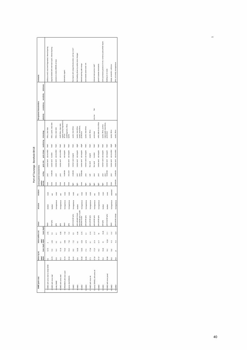
PortofT
auranga-B
oreh
oleBH
18
1
NA
ME
(gra
in s
ize)
colo
urst
ruct
ure
moi
stur
eco
mm
ents
uppe
r de
pth
low
er d
epth
uppe
r de
pth
low
er d
epth
rela
tive
dens
ityso
rtin
ggr
ain
size
grai
n sh
ape
wea
ther
ing
min
eral
ogy
plas
ticity
cons
iste
ncy
sens
itivi
tyst
icki
ness
1S
AN
D w
ith s
ome
shel
l to
shel
ly S
AN
D8.
210
.75
02.
55bl
ack
bedd
edm
oist
loos
epo
orco
arse
san
dsu
b-ro
unde
dfre
shlit
hics
, cle
ar x
tals
sulfe
rous
sm
ell;
mos
t she
ll fra
gmen
ted;
inte
rnal
laye
ring
2S
AN
D w
ith m
inor
she
ll10
.75
13.5
2.55
5.3
dark
gre
ybe
dded
wet
loos
em
oder
ate
coar
se s
and
roun
ded
fresh
lithi
cs, q
uartz
, cle
ar x
tals
vagu
ely
bedd
ed w
ith s
hell
hash
laye
rs; i
nter
nal l
ayer
ing
3sh
elly
SA
ND
13.5
14.3
5.3
6.1
grey
hom
ogen
eous
moi
stlo
ose
poor
coar
se s
and
sub-
roun
ded
fresh
lithi
cs, c
lear
xta
lsco
arse
ns to
she
lly G
RAV
EL
at b
ase
4S
AN
D w
ith s
ome
shel
l14
.315
.18
6.1
6.98
grey
hom
ogen
eous
wet
loos
epo
orco
arse
san
dsu
b-ro
unde
dfre
shsh
ell,
lithi
cs, c
lear
xta
ls
5O
RG
AN
ICS
with
min
or s
and
15.1
815
.22
6.98
7.02
blac
kho
mog
eneo
usm
oist
loos
em
oder
ate
sub-
angu
lar
fresh
orga
nic
woo
dy fr
agm
ents
to
20 m
mdo
min
antly
org
anic
6sa
ndy
shel
l GR
AVE
L15
.22
15.4
17.
027.
21gr
eyho
mog
eneo
usm
oist
loos
eve
ry p
oor
coar
se s
and
sub-
angu
lar
fresh
shel
l fra
gmen
ts, l
ithic
s,
quar
tz
7S
AN
D15
.41
16.5
7.21
8.3
pale
bro
wni
sh g
rey
hom
ogen
eous
moi
sttig
htm
oder
ate
med
ium
san
dan
gula
rfre
shqu
artz
, tra
ce li
thic
sfin
er la
yers
with
ora
nge
disc
olou
ratio
n; s
oil t
op 2
mm
?
8S
AN
D16
.516
.58
8.3
8.38
pale
yel
low
ish
brow
nbe
dded
dry
tight
poor
coar
se s
and
sub-
angu
lar
slig
htqu
artz
, tra
ce li
thic
sfa
int b
eddi
ng s
how
n by
sub
tle c
olou
r cha
nges
9S
AN
D16
.58
16.9
58.
388.
75pa
le p
inki
sh g
rey
to p
ale
yello
wis
h br
own
hom
ogen
eous
moi
stlo
ose
poor
- m
oder
ate
coar
se s
and
sub-
angu
lar
slig
htqu
artz
, som
e lit
hics
, pu
mic
eous
inte
rnal
laye
ring;
pal
e or
ange
10S
AN
D16
.95
17.3
8.75
9.1
pale
pin
kish
gre
yho
mog
eneo
usm
oist
tight
poor
med
ium
san
dsu
b-an
gula
rfre
shqu
artz
, tra
ce li
thic
sso
me
band
s co
arse
san
d / s
ilt
11S
AN
D w
ith m
inor
silt
17.3
17.3
49.
19.
14pa
le p
inki
sh g
rey
hom
ogen
eous
moi
sttig
htw
ell
fine
sand
angu
lar
fresh
quar
tz, l
ithic
s
12sa
ndy
GR
AVE
L w
ith s
ome
silt
17.3
417
.37
9.14
9.17
pale
pin
kish
gre
yho
mog
eneo
usw
ettig
htpo
orfin
e sa
ndro
unde
dfre
shpu
mic
eous
very
low
firm
char
coal
nea
r pum
ice
clas
t?
13S
AN
D17
.37
18.2
9.17
10pa
le p
inki
sh g
rey
hom
ogen
eous
moi
sttig
htpo
orco
arse
san
dsu
b-an
gula
rfre
shw
hite
xta
ls &
min
or li
thic
sgr
avel
incr
ease
s do
wnw
ards
14S
AN
D18
.218
.46
1010
.26
pale
gre
ybe
dded
moi
sttig
htpo
orm
ediu
m s
and
sub-
angu
lar
fresh
quar
tz, l
ithic
s, p
umic
eso
me
pum
iceo
us g
rave
ls to
6 m
m; n
umer
ous
pale
pin
kish
laye
rs
15S
AN
D w
ith m
inor
gra
vel
18.4
619
.310
.26
11.1
pale
bro
wni
sh g
rey
bedd
edm
oist
loos
epo
or -
mod
erat
eco
arse
san
dsu
b-an
gula
rfre
shcl
ear q
uartz
, tra
ce li
thic
s,
pum
iceo
usbe
ddin
g on
cm
sca
le
16S
AN
D19
.519
.611
.311
.4bl
ack
hom
ogen
eous
satu
rate
dlo
ose
poor
coar
se s
and
sub-
roun
ded
slig
htqu
artz
, lith
ics
slop
py, a
naer
obic
, sul
furo
us
17S
AN
D19
.621
11.4
12.8
pale
pin
kish
ora
nge
hom
ogen
eous
wet
mod
erat
em
oder
ate
coar
se s
and
sub-
roun
ded
slig
htqu
artz
, lith
ics
drie
r, no
t sm
elly,
hom
ogen
eous
belo
w r
ig (m
)be
low
sea
floor
(m)
coar
se-g
rain
ed c
hara
cter
istic
sfin
e-gr
aine
d ch
arac
teri
stic
s
40

41

42

43

44
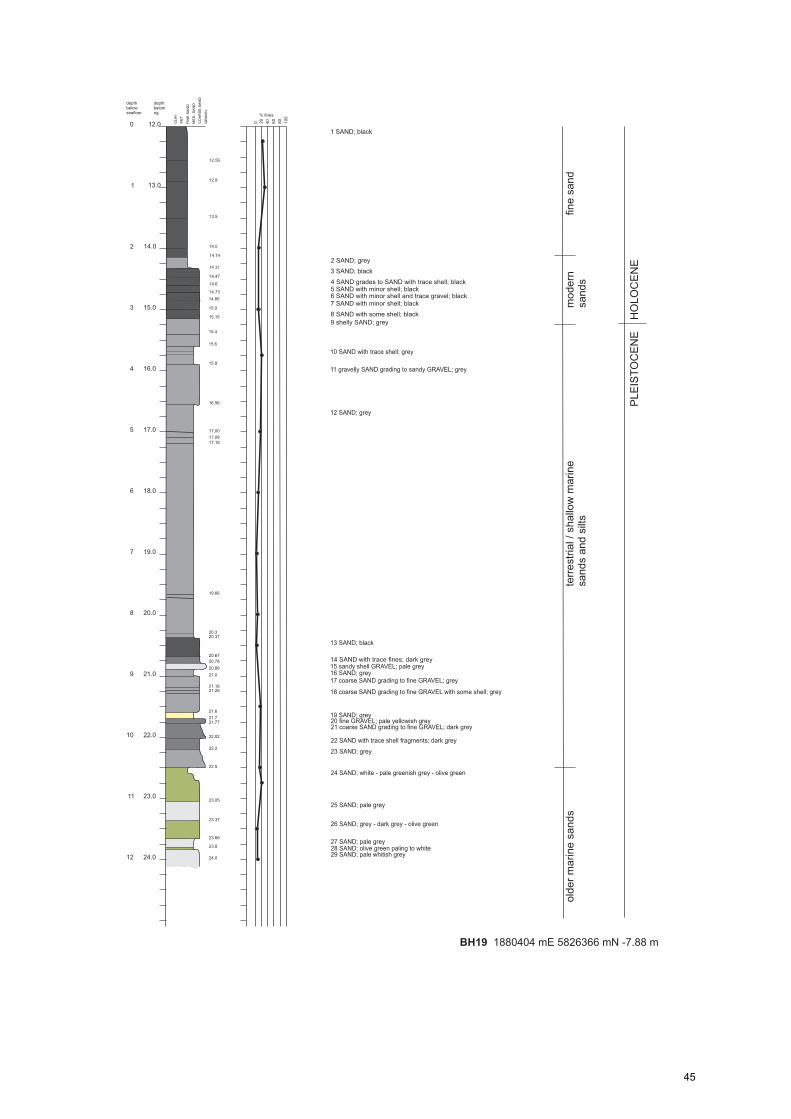
45

PortofT
auranga-B
oreh
oleBH
19
1
NA
ME
(gra
in s
ize)
colo
urst
ruct
ure
moi
stur
eco
mm
ents
uppe
r de
pth
low
er d
epth
uppe
r de
pth
low
er d
epth
rela
tive
dens
ityso
rtin
ggr
ain
size
grai
n sh
ape
wea
ther
ing
min
eral
ogy
plas
ticity
cons
iste
ncy
sens
itivi
tyst
icki
ness
1S
AN
D12
14.1
40
2.14
blac
kho
mog
eneo
usm
oist
tight
wel
lfin
e sa
ndsu
b-ro
unde
dfre
shcl
ear x
tals
firm
sulfu
rous
2S
AN
D w
ith m
inor
silt
14.1
414
.31
2.14
2.31
grey
hom
ogen
eous
wet
tight
wel
lfin
e sa
ndsu
b-an
gula
rfre
shcl
ear q
uartz
firm
no s
mel
l
3S
AN
D14
.31
14.4
72.
312.
47bl
ack
hom
ogen
eous
wet
tight
wel
lm
ediu
m s
and
sub-
roun
ded
fresh
clea
r xta
ls; l
ots
lithi
csfir
m
4S
AN
D; g
rade
s S
AN
D w
ith tr
ace
shel
l14
.47
14.7
32.
472.
73bl
ack
hom
ogen
eous
wet
mod
erat
em
oder
ate
coar
se s
and
sub-
roun
ded
fresh
quar
tz; l
ots
lithi
csfir
mtra
ce s
hell
fragm
ents
5S
AN
D w
ith m
inor
she
ll14
.73
14.8
52.
732.
85bl
ack
hom
ogen
eous
wet
loos
em
oder
ate
very
coa
rse
sand
sub-
roun
ded
fresh
clea
r qua
rtz; l
ots
lithi
cs;
shel
l fra
gmen
ts to
5 m
mso
ftw
eath
ers
to o
live
gree
n
6S
AN
D w
ith m
inor
she
ll &
trac
e gr
avel
14
.85
152.
853
blac
kho
mog
eneo
usw
etlo
ose
poor
coar
se s
and
with
v. f
ine
grav
elsu
b-ro
unde
dfre
shqu
artz
; lith
ics;
she
ll fra
gmen
tsso
ft
7S
AN
D w
ith m
inor
she
ll15
15.1
53
3.15
blac
kho
mog
eneo
usw
etlo
ose
poor
coar
se s
and
sub-
angu
lar
fresh
quar
tz; l
ots
lithi
cs; s
hell
fragm
ents
firm
8S
AN
D w
ith s
ome
shel
l15
.15
15.4
3.15
3.4
blac
kho
mog
eneo
usw
etlo
ose
poor
coar
se s
and
sub-
roun
ded
fresh
quar
tz; l
ots
lithi
cs; s
hell
fragm
ents
firm
coar
ser t
han
laye
r 7
9sh
elly
SA
ND
15.4
15.6
3.4
3.6
grey
hom
ogen
eous
moi
stlo
ose
mod
erat
eve
ry c
oars
e sa
ndsu
b-ro
unde
dfre
shqu
artz
; lith
ics;
she
ll fra
gmen
tsve
ry s
helly
laye
r
10S
AN
D w
ith tr
ace
shel
l15
.615
.93.
63.
9gr
eyho
mog
eneo
usw
ettig
htm
oder
ate-
wel
lm
ediu
m s
and
sub-
angu
lar
fresh
quar
tz; l
ithic
s; s
hell
fragm
ents
firm
-stif
fla
rge
piec
e w
ood
15.6
8 m
11sa
ndy
shel
l GR
AVE
L15
.916
.56
3.9
4.56
grey
hom
ogen
eous
wet
loos
epo
orv
coar
se
sand
sub-
angu
lar
fresh
quar
tz; l
ithic
s; s
hell
fragm
ents
12S
AN
D16
.56
20.3
74.
568.
37gr
eyho
mog
eneo
usm
oist
tight
mod
erat
em
ediu
m s
and
angu
lar
fresh
quar
tz; l
ithic
sfir
m-s
tiff
som
e ba
nds
with
she
ll fra
gmen
ts
13S
AN
D20
.37
20.6
78.
378.
67bl
ack
hom
ogen
eous
wet
loos
epo
orco
arse
san
dro
unde
dfre
shlo
ts li
thic
s, c
lear
qua
rtz,
trace
she
llsu
lfuro
us
14S
AN
D w
ith tr
ace
fines
20.6
720
.78
8.67
8.78
dark
gre
yho
mog
eneo
usm
oist
tight
poor
coar
se s
and
sub-
angu
lar
fresh
lithi
cs, q
uartz
15sa
ndy
shel
l GR
AVE
L20
.78
20.8
98.
788.
89pa
le g
rey
hom
ogen
eous
moi
stlo
ose
mod
erat
ev
coar
se
sand
angu
lar
fresh
shel
l, lit
hics
, min
or q
uartz
16S
AN
D20
.89
218.
899
grey
hom
ogen
eous
moi
sttig
htw
ell
med
ium
san
dsu
b-ro
unde
dfre
shqu
artz
; lith
ics
17S
AN
D21
21.1
89
9.18
grey
bedd
edm
oist
loos
em
oder
ate
coar
se s
and
roun
ded
fresh
lithi
cs, q
uartz
, she
llla
yers
17
& 1
8 re
peat
ed s
eque
nce
of fi
ne (t
op) t
o co
arse
(bas
e)
18S
AN
D21
.18
21.6
9.18
9.6
grey
bedd
edm
oist
loos
em
oder
ate
coar
se s
and
sub-
roun
ded
fresh
quar
tz, l
ithic
s, s
ome
shel
les
sent
ially
the
sam
e
19S
AN
D21
.621
.74
9.6
9.74
grey
hom
ogen
eous
dry
tight
mod
erat
em
ediu
m s
and
sub-
roun
ded
fresh
quar
tz, l
ithic
sfir
m
20fin
e G
RAV
EL
21.7
421
.77
9.74
9.77
pale
yel
low
ish
brow
nho
mog
eneo
usm
oist
loos
em
oder
ate
fine
grav
elsu
b-ro
unde
dfre
shqu
artz
, lith
ics
no s
hell
21S
AN
D21
.77
22.0
29.
7710
.02
dark
gre
ybe
dded
moi
stlo
ose
mod
erat
eco
arse
san
dsu
b-ro
unde
dfre
shqu
artz
, lith
ics
grad
es d
ownw
ards
22S
AN
D22
.02
22.2
10.0
210
.2da
rk g
rey
hom
ogen
eous
moi
stlo
ose
mod
erat
eco
arse
san
dsu
b-ro
unde
dfre
shqu
artz
, lith
ics
trace
dis
colo
ured
she
ll fra
gmen
ts
23S
AN
D22
.222
.510
.210
.5gr
eybe
dded
moi
stlo
ose
poor
coar
se s
and
sub-
angu
lar
fresh
quar
tz, l
ithic
s, s
hell
grad
es to
san
dy s
hell
GR
AVE
L
24S
AN
D22
.523
.05
10.5
11.0
5w
hite
to o
live
gree
nho
mog
eneo
usdr
ytig
htw
ell
fine
sand
sub-
angu
lar
fresh
quar
tzst
ifflo
oser
, sof
ter &
coa
rsen
s w
ith d
epth
; bec
omes
gre
en
25S
AN
D23
.05
23.3
711
.05
11.3
7pa
le g
rey
bedd
edm
oist
tight
mod
erat
eco
arse
san
dsu
b-an
gula
rfre
shqu
artz
, lith
ics
shel
l fra
gmen
ts to
15
mm
26S
AN
D23
.37
23.6
611
.37
11.6
6da
rk g
rey
- oliv
e gr
een
bedd
edm
oist
loos
em
oder
ate
coar
se s
and
sub-
roun
ded
fresh
quar
tz, l
ithic
sva
gue
horiz
onta
l bed
ding
27S
AN
D23
.66
23.8
11.6
611
.8pa
le g
rey
hom
ogen
eous
moi
sttig
htw
ell
med
ium
san
dsu
b-an
gula
rfre
shqu
artz
, few
lith
ics
28S
AN
D23
.823
.84
11.8
11.8
4ol
ive
gree
n to
whi
tebe
dded
dry
tight
poor
to
mod
erat
em
ediu
m s
and
angu
lar
fresh
quar
tz, l
ithic
sst
iff
29S
AN
D23
.84
2411
.84
12pa
le w
hitis
h gr
eyho
mog
eneo
usm
oist
tight
mod
erat
eco
arse
san
dsu
b-ro
unde
dfre
shqu
artz
, lith
ics
belo
w r
ig (m
)be
low
sea
floor
(m)
coar
se-g
rain
ed c
hara
cter
istic
sfin
e-gr
aine
d ch
arac
teri
stic
s
46
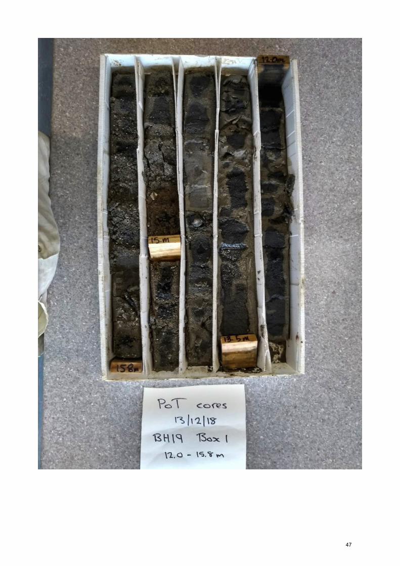
47
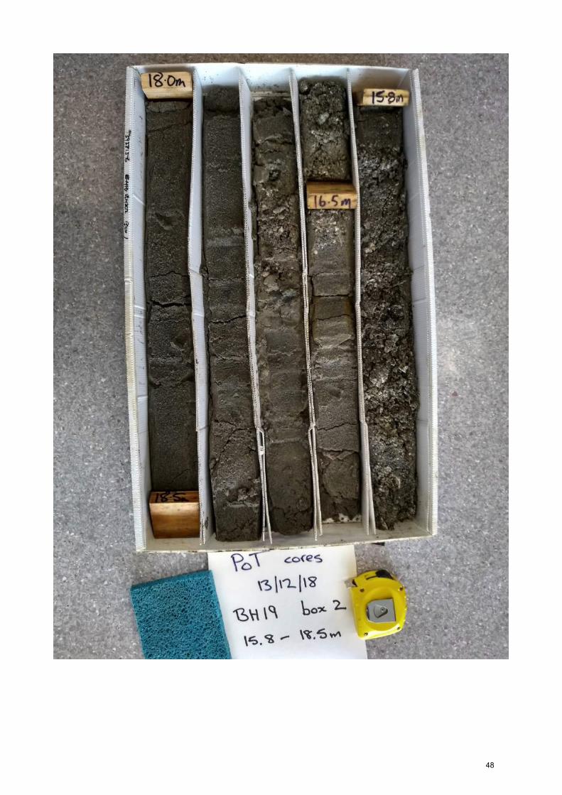
48

49

50
Appendix B – CPT traces and interpretation ThefollowingpagesincludetheCPTdataobtainedforCPT21toCPT28inthesouthernStellaPassage(Figure3).Thetracesareannotatedwiththeinterpretedstratigraphicunitsbasedonboreholedata.
51

52

53

54

55

56

57

58

59

3
Appendix C – Particle size analysis results The following tables summarise the Malvern Lasersizer textural analysis results for thesamplesobtainedfromtheboreholecoresobtainedbyOPUS.Thedepthof thesample isgivenrelativetodatum(R.L.)andtheseabedasmeasuredduringthecoring.Theproportionoffinesrepresentsthesumofsiltandclayfractions.Thereportedmeangrainsizesweredeterminedusingthemomentmethod.Sampleswithgravel>2mmthatwasremovedpriortomeasurementbytheLasersizer,arecorrectedfortheproportionofgravelpresentintheoriginalsample.
60

Sample Sieve analysisSand Fines Silt Clay Mean Sorting Skewness Kurtosis Mean >2mm <2mm Corrected
(Mz) (SD) (Sk) (KG) Fines(%) (%) (%) (%) (mm) (%) (%) (%)
BH15-9.55 78.43 21.57 12.15 9.42 2.20 1.98 0.48 1.46 0.217 15.55 84.45 18.22
BH15-10.1 58.07 41.93 22.24 19.69 3.20 2.97 0.42 0.86 0.109
BH15-10.7 29.63 70.37 24.24 46.13 5.42 3.47 -0.03 0.72 0.023
BH15-10.9 28.58 71.42 34.80 36.62 5.11 2.68 0.21 0.81 0.029
BH15-11.3 40.18 59.82 30.57 29.25 4.57 2.96 0.29 0.84 0.042
BH15-11.8 47.67 52.33 30.96 21.37 3.78 2.81 0.23 0.91 0.073
BH15-12.3 47.87 52.13 21.99 30.14 4.37 3.26 0.38 0.73 0.048
BH15-13.05 41.48 58.52 45.15 13.37 3.74 2.05 0.05 0.93 0.075
BH15-13.8 29.42 70.58 40.6 29.98 4.63 2.56 0.02 0.94 0.040
BH15-14.8 22.19 77.81 49.97 27.84 4.81 2.01 -0.03 0.99 0.036
BH15-15.5 22.85 77.15 42.9 34.25 4.94 2.21 -0.10 0.96 0.033
BH15-16.8 12.12 87.88 22.25 65.63 7.09 2.92 -0.20 0.81 0.007
BH15-17.55 28.65 71.35 31.24 40.11 5.19 3.01 0.08 0.82 0.027
BH15-18.0 35.79 64.21 27.22 36.99 4.91 3.25 0.15 0.74 0.033
BH15-18.8 9.84 90.16 38.12 52.04 6.38 2.54 0.10 0.82 0.012
BH15-19.55 5.25 94.75 31.13 63.62 7.20 2.54 0.00 0.82 0.007
BH15-20.05 12.93 87.07 38 49.07 6.02 2.44 0.03 0.91 0.015
BH15-20.8 32.29 67.71 48.37 19.34 4.17 2.26 0.08 1.12 0.055
BH16-8.45 86.2 13.8 7.97 5.83 1.65 1.55 0.42 1.69 0.319 5.85 94.15 11.65
BH16-9.2 23.21 76.79 32.81 43.98 5.70 3.02 0.10 0.79 0.019
BH16-10.2 60.23 39.77 26.77 13 2.88 2.43 0.34 0.89 0.136
BH16-10.8 27.52 72.48 25.47 47.01 5.08 3.67 -0.20 0.86 0.030
BH16-11.7 52.5 47.5 26.58 20.92 3.69 2.72 0.39 0.92 0.078
BH16-12.7 18.77 81.23 53.85 27.38 5.05 2.22 0.34 1.10 0.030
BH16-13.7 76.2 23.8 17.19 6.61 2.12 1.96 0.44 1.16 0.230
BH16-14.7 69.64 30.36 18.11 12.25 2.57 2.45 0.48 1.15 0.168
BH16-15.2 7.28 92.72 49.44 43.28 6.04 2.29 0.28 0.85 0.015
BH16-15.9 8.13 91.87 53.98 37.89 5.68 2.08 0.28 0.95 0.019
BH16-16.7 2.99 97.01 53.01 44 5.99 1.85 0.23 0.95 0.016
BH16-17.2 8.85 91.15 74.63 16.52 4.75 1.44 0.29 1.30 0.037
BH16-17.8 17.29 82.71 66.25 16.46 4.51 1.59 0.36 1.28 0.044
BH16-18.7 39.05 60.95 42.04 18.91 3.86 2.47 0.04 0.96 0.069
BH16-20.2 81.43 18.57 15.09 3.48 1.76 1.70 0.44 1.31 0.294
BH17-8.75 73.72 26.28 14.24 12.04 2.69 2.09 0.57 1.35 0.155 25.02 74.98 22.19
BH17-9.5 80.09 19.91 12.63 7.28 2.18 1.71 0.41 1.61 0.221 25.02 74.98 16.81
BH17-10.0 62.96 37.04 28.26 8.78 3.03 1.63 0.35 1.48 0.122
BH17-10.75 57.11 42.89 24.52 18.37 3.42 2.50 0.42 0.90 0.094 72.75 27.25 36.22
BH17-11.5 54.48 45.52 31.41 14.11 3.44 2.17 0.33 1.28 0.092
BH17-11.8 37.64 62.36 43.95 18.41 4.16 2.09 0.36 1.17 0.056
BH17-13.0 37.53 62.47 52.26 10.21 3.80 1.53 0.30 1.36 0.072
BH17-14.0 49.14 50.86 40.9 9.96 3.50 1.71 0.29 1.20 0.088
BH17-15.25 59.85 40.15 30.17 9.98 3.11 1.84 0.32 1.21 0.116
BH17-16.5 51.62 48.38 39.08 9.3 3.44 1.59 0.32 1.17 0.092
BH17-17.5 46.81 53.19 35.97 17.22 3.75 2.27 0.27 1.03 0.074
BH17-18.5 86.14 13.86 11.3 2.56 1.86 1.24 0.32 1.29 0.276
BH17-19.5 58 42 33.46 8.54 3.13 1.73 0.26 1.18 0.114
BH17-20.5 55.99 44.01 34.55 9.46 3.22 1.81 0.26 1.17 0.108
BH18-8.45 87.64 12.36 5.23 7.13 1.87 1.32 0.36 2.28 0.273
BH18-9.2 79.79 20.21 9.27 10.94 2.60 1.97 0.60 1.92 0.165
BH18-10.2 77.62 22.38 10.14 12.24 2.66 2.13 0.60 1.72 0.159
BH18-11.2 77.69 22.31 14.42 7.89 2.52 1.69 0.53 1.59 0.175
BH18-12.2 77.82 22.18 12.22 9.96 2.56 1.94 0.55 1.72 0.169
BH18-13.2 81.32 18.68 10.77 7.91 2.48 1.52 0.52 1.99 0.180
BH18-14.2 75.53 24.47 13.75 10.72 2.50 2.04 0.55 1.45 0.177 12.75 87.25 20.66
BH18-15.2 54.43 45.57 25.26 20.31 3.46 2.81 0.28 0.93 0.091
BH18-15.7 51.29 48.71 33.98 14.73 3.58 2.08 0.33 1.03 0.084
BH18-16.7 45.46 54.54 31.47 23.07 4.06 2.50 0.34 0.91 0.060
BH18-17.7 54.53 45.47 29.42 16.05 3.47 2.32 0.34 1.07 0.090
BH18-18.7 72.11 27.89 24.81 3.08 2.56 1.36 0.21 1.11 0.169
BH18-19.7 62.54 37.46 30.16 7.3 2.96 1.69 0.27 1.17 0.129
BH18-20.7 57.71 42.29 32.42 9.87 3.19 1.87 0.29 1.14 0.110
Lasersizer analysis
61

Sample Sieve analysisSand Fines Silt Clay Mean Sorting Skewness Kurtosis Mean >2mm <2mm Corrected
(Mz) (SD) (Sk) (KG) Fines(%) (%) (%) (%) (mm) (%) (%) (%)
Lasersizer analysis
BH19-12.25 67.06 32.94 21.44 11.5 3.17 1.87 0.45 1.48 0.111
BH19-13.0 59.33 40.67 24.86 15.81 3.56 2.06 0.48 1.12 0.085
BH19-14.0 86.82 13.18 7.81 5.37 2.01 1.44 0.19 2.10 0.247
BH19-15.0 86.76 13.24 10.74 2.5 1.69 1.36 0.24 1.48 0.310
BH19-15.75 67.33 32.67 28.2 4.47 2.57 1.74 0.17 1.01 0.168
BH19-17.0 81.59 18.41 13.08 5.33 2.11 1.63 0.30 1.49 0.232
BH19-18.0 89.15 10.85 8.36 2.49 1.87 1.04 0.32 1.70 0.273
BH19-19.0 92.56 7.44 4.53 2.91 1.88 1.04 0.19 1.56 0.273
BH19-20.0 90.85 9.15 6.15 3 2.05 0.99 0.26 1.61 0.242
BH19-20.5 93.43 6.57 4.29 2.28 1.81 0.97 0.22 1.55 0.285
BH19-21.5 79.86 20.14 13.25 6.89 1.33 2.39 0.51 1.13 0.397
BH19-22.5 75.99 24.01 14.56 9.45 2.21 2.12 0.47 1.36 0.216 22.74 77.26 20.27
BH19-22.75 73.66 26.34 18.07 8.27 2.49 1.87 0.58 1.12 0.179
BH19-23.5 92.69 7.31 5.4 1.91 1.51 0.91 0.30 1.76 0.351
BH19-24.0 89.51 10.49 7.96 2.53 1.61 1.13 0.32 1.66 0.327
62