CHAPTER SIX NATURAL RESOURCES ELEMENT...Dahlonega Upland District, which is a rough and hilly...
42
6-1 CHAPTER SIX NATURAL RESOURCES ELEMENT This chapter provides an inventory of the natural and historic resources in White County, assesses the natural environmental limitations posed on future development, and establishes a set of goals and objectives designed to protect and preserve the natural and historic resources of the County. Weather And Climate The climate of White County is strongly influenced by mountainous terrain. Summers are mild and winters are quite cold. Generous precipitation occurs throughout the year with heavier amounts in winter and early spring. The complex terrain and contrasting elevations of White County creates highly variable weather conditions. High elevation mountain areas are commonly 5 to 10 degree colder during the day than valley bottoms. In the evening, cold air flows off of the high slopes into the valleys. In these bottom lands, early morning temperatures can be 10 to 15 degrees colder than surrounding areas. Precipitation varies as well. High elevations receive more rainfall and snow than lowlands, as air is forced to rise and cool as it pushed over mountains. Elevation changes alone can increase annual precipitation by 10 inches or more, when compared to nearby lowlands. Microclimates at high elevations are common, and lead to greater biodiversity than surrounding counties that have only low elevations. The Southeast Regional Climate Center’s Clarkesville and Helen stations have weather and climate records from 1961 to 2000. Maximum summer temperatures during this time averaged in the middle to high 80’s. July is the warmest month, with the average highs of 86-5 degrees. Lows during the summer are comfortable, and average between the high 50’s and low 60’s. Average high temperatures during the winter months are in the low to middle 50’s. January is the coldest month with an average high temperature of 50.9, and an average low temperature of 29.4. Average low temperatures throughout the winter months range from the high 20’s to the high 30’s. Precipitation in White County follows a winter maximum regime with a second peak of precipitation during summer months. In the Town of Cleveland, December through March are the wettest months, during which time the city receives between 5.71 and 6-94 inches of precipitation per month. July and August also see considerable rainfall. During these months, Cleveland receives a monthly average of 5.64 and 5.37 inches of rain. Snowfall can occur during winter months, especially at higher elevations. Cleveland averages 2.6 inches a year while Helen’s average snowfall is 3.4 inches. The fall and early summer are the driest periods. During this time, monthly precipitation averages between 4.24 and 5.19 inches of rain.
Transcript of CHAPTER SIX NATURAL RESOURCES ELEMENT...Dahlonega Upland District, which is a rough and hilly...

6-1
CHAPTER SIX
NATURAL RESOURCES ELEMENT
This chapter provides an inventory of the natural and historic resources in White County,assesses the natural environmental limitations posed on future development, and establishes a setof goals and objectives designed to protect and preserve the natural and historic resources of theCounty.
Weather And Climate
The climate of White County is strongly influenced by mountainous terrain. Summers aremild and winters are quite cold. Generous precipitation occurs throughout the year with heavieramounts in winter and early spring.
The complex terrain and contrasting elevations of White County creates highly variableweather conditions. High elevation mountain areas are commonly 5 to 10 degree colder duringthe day than valley bottoms. In the evening, cold air flows off of the high slopes into the valleys.In these bottom lands, early morning temperatures can be 10 to 15 degrees colder thansurrounding areas. Precipitation varies as well. High elevations receive more rainfall and snowthan lowlands, as air is forced to rise and cool as it pushed over mountains. Elevation changesalone can increase annual precipitation by 10 inches or more, when compared to nearby lowlands.Microclimates at high elevations are common, and lead to greater biodiversity than surroundingcounties that have only low elevations.
The Southeast Regional Climate Center’s Clarkesville and Helen stations have weatherand climate records from 1961 to 2000. Maximum summer temperatures during this timeaveraged in the middle to high 80’s. July is the warmest month, with the average highs of 86-5degrees. Lows during the summer are comfortable, and average between the high 50’s and low60’s.
Average high temperatures during the winter months are in the low to middle 50’s.January is the coldest month with an average high temperature of 50.9, and an average lowtemperature of 29.4. Average low temperatures throughout the winter months range from thehigh 20’s to the high 30’s.
Precipitation in White County follows a winter maximum regime with a second peak ofprecipitation during summer months. In the Town of Cleveland, December through March arethe wettest months, during which time the city receives between 5.71 and 6-94 inches ofprecipitation per month. July and August also see considerable rainfall. During these months,Cleveland receives a monthly average of 5.64 and 5.37 inches of rain. Snowfall can occur duringwinter months, especially at higher elevations. Cleveland averages 2.6 inches a year whileHelen’s average snowfall is 3.4 inches. The fall and early summer are the driest periods. Duringthis time, monthly precipitation averages between 4.24 and 5.19 inches of rain.

6-2
Physiography
White County lies within two physiographic provinces: the Blue Ridge District and thePiedmont District. The north and northwest sections of the County are within the Blue RidgeMountains District, which consists of rugged mountains and ridges ranging in elevation from3,000-4,700 feet. The southern boundary of the Blue Ridge Province abuts the Piedmont Provinceat approximately the 1,700 ft. elevation where a sharp contrast in regional slope occurs.
The portion of White County that falls within the Piedmont Province can be subdividedinto three different districts. A small middle-western portion of the County lies within theDahlonega Upland District, which is a rough and hilly section standing 1,500 to 1,700 feet abovesea level. Streams in this district flow south out of the Blue Ridge Mountains District and havecut deep, narrow valleys 500 to 600 feet below the surrounding surface. Running in a southwestto northeast direction in the southwest and central portions of White County, at a width ofapproximately five miles, is the Hightower-Ridges District. This district contains a series of low,linear, parallel ridges separated by narrow valleys. The Hightower Ridges range in elevation from1,000 feet in the southwest to1,500 feet in the northeast. The remainder of White County(southern and eastern portions) lies within the Central Uplands District, which encompasses aseries of low, linear ridges 1,300 to 1,500 feet above sea level separated by broad, open valleys.Streams flowing through this section occupy valleys 150 to 200 feet below the ridge crests.(Source: Georgia Department of Natural Resources, Geologic and Water Resources Division.Physiographic Map of Georgia. 1976-)
Geology
Georgia is divided into three geologic provinces based on rock types. These geologicregions conform to the physiographic provinces except that the Blue Ridge and Piedmontphysiographic provinces are combined in the Piedmont-Mountain geologic province, withinwhich White County is located.
The Piedmont-Mountain province is underlain by metamorphic and igneous rocks,commonly known as crystalline rocks. The metamorphic rocks are the most extensive in theprovince and include biotite gneiss, muscovite schist, slate, quartzite, and marble. The igneousrocks are composed primarily of granite. Above the solid rock is a mantle of weathered soil orregolith (decayed rock), which ranges in thickness from 5 to 80 feet, depending upon the type ofrock. This mantle of decayed rock is usually thickest in valleys and thinnest on hilltops. (Source:Department of Mines, Mining and Geology, State Division of Conservation, Bulletin Number 65,The Availability and Use of Water in Georgia. 1956-)
Mineral Resources
White County has a variety of mineral resources. Two areas within the County containgranite and related rock outcrops: One area in the mid-northwest section; and one area in theextreme northeast portion of the County. An area of gold deposits, approximately four miles wideby fifteen miles long, bisects the central portion of White County running southwest to northeastin the same general pattern as the Hightower Ridge. This area is known as the "Dahlonega Belt".Paralleling the span of gold deposits to the south is a broken concentration of granite and relatedrocks. There is also a concentration of mica (colored or transparent mineral silicates that separate

6-3
into thin leaves and used dry in roofing materials, joint cement, well drilling compounds andpaint) located east of State Route 75 and north of State Route 254.
Other mineral resources found in lesser quantities in White County are: corundum (a veryhard mineral that consists of aluminum oxide and which is used as an abrasive); feldspar(crystalline minerals consisting of aluminum silicates which is ground and used in themanufacture of glass, pottery, enamels and abrasives); iron and manganese; sulfide deposits (iron,copper, etc.); talc (a soft mineral that is a basic magnesium silicate and which is used as a filler inrubber); asbestos (a mineral supposed to be inextinguishable when set on fire, used for chemicalfilters and plastics); sillimanite (a mineral consisting of aluminum silicate which has uses in theproduction of high temperature refractories); quartzite (a compact granular rock composed ofquartz and derived from sandstone); and soapstone (a soft stone having a soapy feel andcomposed of talc, chlorite and magnetite). (Sources: Georgia Department of Mines, Mining andGeology, The Common Rocks and Minerals of Georgia. Information Circular No. 5,1934,Revised 1964. Georgia Department of Natural Resources, Georgia Geologic Survey, MineralResources Map. 1969.)
A deposit study of mineral deposits in White County was completed in 1964. This studyconcluded, among other things, that the "volume and grade of gravels in the Nacoochee Valley,Sautee Creek, Bean Creek and Dukes Creek warrant a dredging operation," and that "othereconomic materials which might be worked are asbestos, mica and soapstone."
Although there are a variety of mineral resources located in White County, mining andquarrying operations are limited to fill material, gold and sand-construction commodities.
Soil Types
An analysis of the types of soils in White County and their suitability for certain land usesis an important component of the Comprehensive Plan. White County has a broad range of soils,which are listed by symbol and name in Table 6-2, along with the limitations of each soil type oncrop cultivation, dwelling foundations, septic tank utilization, and commercial structures. Map 6-1 provides a generalized distribution of major soil types in White County.
Of the 55 soil types indicated in Table 6-2, there are 17 soil types, which have beenidentified with an asterisk (*) as suitable for intensive crop cultivation. The soils most suitable forcrop cultivation are found on lesser slopes (2-10%). Most of the soils in White County havelimitations for intensive crop cultivation because of steep slopes, severe erosion hazards,flooding, low natural fertility, low organic matter content, shallow depth of rooting zone, rockoutcrops, and/or surface stones. Although only 17 soil types are found suitable for intensive cropcultivation, other soil types can be and are cultivated for crops. Furthermore, many of the soils notidentified as suitable for intensive crop cultivation are suitable for other agricultural uses such aspasture and woodlands. The vast majority of land areas in White County have soils, which posesevere limitations on dwelling foundations and septic tank utilization. The Masada soilassociation (MoB, MoB2, MoC2, MoD2) is the most suitable soil for these uses. Approximately28,190 acres, or 18% of the total County land area, have only slight to moderate limitations ondwelling foundations and septic tank utilization. Even less of the County land area has soils suitedfor commercial and light industrial uses without extensive adjustments; approximately 26,365acres, or 17% of the total County land area, contain soils with only moderate limitations on

6-4
commercial structures.
White County lies within the Upper Chattahoochee River Soil and Water ConservationDistrict along with Dawson, Forsyth, Hall, Habersham and Lumpkin Counties. Soil and waterconservation districts were formed in Georgia by 1957 with the purpose of providing localdirection to federal conservation efforts. In addition to basic duties such as coordinating programsand developing annual and long-range plans, the districts sponsor demonstration projects andconservation workshops. (Source: Georgia Soil and Water Conservation Committee, GeorgiaResource Conservation Program and Action Plan,.)
TABLE 6-1 Limitations of Soils
on Development
SYMBOL SOIL NAME (% SLOPE) FOUNDATION FORDWELLINGS
SEPTIC TANKUTILIZATION
COMMERCIALSTRUCTURES
AcG As he stony loam (60-90) Se Se Se
AEE Ashe/Edneyville stony loam Se Se Se(10-25)
AEF Ashe/Edneyville stony loam Se Se Se(26-60)
AmC2* Appling sandy loam (6-10) Sl M MAWB** Augusta fine sandy loamy (2- Se Se Se
6)AwC Augusta fine sandy loam Se Se Se
(6-10)Bfs Buncombe loamy sand Se Se SeBvF Burton loam (16-50) Se Se SeCac** Cartecay complex Se Se SeCCF Chandler loam (26-60) Se Se SeCon* Conagree/Starr soils Se Se SeEPD Edneyville/Porters loams M M Se
(10-15)EPE Edneyville/Porters loams Se Se Se
(16-25)EPF Edneyville/Porters loams Se Se Se
(26-60)EPG Edneyville/Porters loams Se Se Se
(60-80)FaB* Fannin fine sandy loam (2-6) Sl M MFaC* Fan n in fine sandy loam Sl M M
(6-10)FaE Fannin fine sandy loam MtoSe Se Se
(10-25)FbC2* Fannin sandy clay loam Sl M M
(6-10)FbE2 Fannin sandy clay loam Se Se Se
(10-25)FcF Fannin soils (26-60) Se Se SeGut Gullied land Not RatedHIB* Hayesville sandy loam Sl M M
(2-6)HIC* Hayesville sandy loam Sl M M
(6-10)HIE Hayesville sandy loam MtoSe Se Se
(10-25)

6-5
TABLE 6-1 (Continued)Limitations of Soils on Development
SYMBOL SOIL NAME (% SLOPE) FOUNDATION FORDWELLINGS
SEPTIC TANKUTILIZATION
COMMERCIALSTRUCTURES
HJC3* Hayesville sandy clay loam Sl M M
(6-10)HJE3 Hayesville sandy clay loam Se Se Se
(10-25)HKC3 Hayesville/Rabun clay loam Sl M M
(6-10)HLC* Hayesville/Rabun loams Sl M M
(6-10)HLD Hayesville/Rabun loams M Se Se
(10-15)HLF Hayesville/Rabun loams Se Se Se
(26-60)HSC* Hiwassee loam (2-10) Sl SItoM MHSD* Hiwassee loam (10-15) M M MHSF Hiwassee loam (16-40) Se Se SeMCE Musella cobbly loam (6-25) Se Se SeMCG Musella cobbly loam (26-70) Se Se SeMoB* Masada fine sandy loam (2-6) Sl Sl MMoB2* Masada fine sandy loam (2-6) Sl Sl MMoC2* Masada fine sandy loam Sl Sl M
(6-10)MoD2* Masada fine sandy loam M M Se
(10-15)MuE2 Musella gravelly clay loam MtoSe Se Se
(10-25)RaE Rabun loam (16-25) M Se SeRbD3 Rabun clay loam (10-15) M M SeRbE3 Rabun clay loam (16-25) Se Se SeSta* Starr fine sandy loam Se Se SeTbE Tallapoosa cobbly fine sandy Se Se Se
loam (6-25)TcE Tallapoosa fine sandy loam MtoSe Se Se
(10-25)TdG Tallapoosa soils (26-70) Se Se SeTIC* Tusquitee loam (6-10) Sl Sl MTID Tusquitee loam (10-25) MtoSe MtoSe SeTIF Tusquitee loam (26-60) Se Se SeTmE Tusquitee stony loam (10-25) Se Se SeTmF Tusquitee stony loam (26-60) Se Se SeToe* (**) Toccoa soils (0-2) Se Se SeWed** Wehadkee soils (0-2) Se Se SeWgC* Wickham fine sandy loam Sl Sl M
(6-10)WgD Wickham fine sandy loam MtoSe MtoSe Se
(10-25)WgF Wickham fine sandy loam Se Se Se
(26-50)WnD3 Wickham sandy clay loam M M Se
(10-15)
Notes: * - Suitable for farming (cultivated crops) without fertilization, drainage or otheradjustments. ** - Hydric soils, according to Soil Conservation Service.
Se - Severe limitations, extensive adjustments are needed before the soil is suitable for the specified
purpose. M - Moderate limitations, some adjustments needed for use. Sl - Slight limitations, little or noadjustments needed for use.
SOURCE: Soil Survey of Dawson, Lumpkin and White Counties,
Georgia U.S. Department of Agriculture, Soil
Conservation Service, 1972.

6-6
Table 6-2 provides acreage estimates for the most frequent soil types in White County, aswell as total acreage estimates of soils with certain characteristics (hydric soils, steep slopes,etc.).
TABLE 6-2Acreage And Percent Of Total County Land By
Most Frequent And Selected Composite Soil
Types
TdG Tallapoosa soils (26-70) 20,825 13.39
HIE Hayesville sandy loam (10-25) 15,485 9.96EPF Edneyville/Porters loams (26-60) 11,035 7.10FaE Fannin fine sandy loam (10-25) 7,610 4.89TID Tusquitee loam (10-25) 6-600 4.24HJE3 Hayesville sandy clay loam (10-25) 6,580 4.23AEF Ashe/Edneyville stony loams (26-60) 5,820 3.74TmF Tusquitee stony loam (26-60) 4,995 3.21FbE2 Fannin sandy clay loam (10-25) 4.220 2.71EPE Edneyville/Porters loams (16-25) 4,065 2.61HIC Hayesville sandy loam (6-10) 3,880 2.49Cac Cartecay complex 3,630 2.33Toe Toccoa soils 3,615 2.32TIF Tusquitee loam (26-60) 3,270 2.10HJC3 Hayesville sandy clay loam (6-10) 3,230 2.07AcG Ashe stony loam (60-90) 3,055 1.96WgD Wickham fine sandy loam (10-25) 3,055 1.96— OTHER SOILS 44,550 28.69
TOTAL HYDRIC SOILS 8,385 5.39
TOTAL PRIME AGRICULTURALSOILS* 28,655 18.43
SOILS WITH 25%SLOPE OR MORE
SOILS SUITABLE FORSEPTIC TANKS**
SOILS SUITABLE FORCOMMERCIALSTRUCTU
RES**
SYMBOL SOIL NAME (% SLOPE) TOTAL ACRES % TOTAL
COUNTYACREAGE
TOTAL 54,225 34.87
TOTAL 28,190 18.13
TOTAL 26,365 16-95
TOTAL
WHITE
COUNTY
155,520 100.0%

6-7
SOURCE: Soil Survey of Dawson, Lumpkin and White Counties, Georgia. U.S.Department of Agriculture Soil Conservation Service, 1972.
NOTES: *Excludes the Toccoa soil type, which is considered a hydric soil and therefore notincluded as prime agricultural soil. **With only slight or moderate limitations.

6-8
Map 6-1

6-9
Steep Slopes
Due to its location in the Blue Ridge and Piedmont Physiographic provinces, WhiteCounty has a number of mountains, which pose limitations on development. A total of 34.87percent (54,225 acres) of the County area qualifies as steep slopes. The highest elevations inWhite County are located along the northern county boundary with Lumpkin, Union, Towns, andHabersham Counties. This county line also forms the Tennessee Valley Divide, which separatesthe Chattahoochee River Basin from the Tennessee River Basin. The Tennessee Valley Dividecontains some of the highest elevations in North Georgia. Table 6-3 provides a listing ofmountains by planning area with approximate elevation.
TABLE 6-3 Mountains InWhite County By Planning
Area and ApproximateElevation
Name of Mountain Planning Area Approximate Elevation
Tatum Mountain Blue Creek 1615'
Sal Mountain Blue Creek 2270'Collins Mountain Blue Ridge 2120'+Horse Range Mtn. Blue Ridge 3162'White Oak Mtn. Blue Ridge 3040'+Pinnacle Mountain Blue Ridge 3133'Little Buzzard Mtn. Blue Ridge 2560'+Allison Mountain Blue Ridge 2920'+Piney Mountain Blue Ridge 3121'Rocky Mountain Blue Ridge 3532'Adams Bald Blue Ridge 3620'Wildcat Mountain Blue Ridge 3760'+Cowrock Mountain Blue Ridge 3590'Yonah Mountain Mount Yonah 3156'Pink Mountain Mount Yonah 2623'Leadpole Mountain Mount Yonah 2130'Skitt Mountain Mossy Creek 2076'Tray Mountain Nacoochee 4430'Chimney Mountain Nacoochee 3357'Lynch Mountain Nacoochee 2080'+Hickory Nut Mtn. Robertstown 2780'Little Hky. Nut. Mtn. Robertstown 2681'Stony Knob Robertstown 2888'Poor Mountain Robertstown 3612'Sheep Rock Top Robertstown 3572'Trail Ridge Robertstown 2690'York Ridge Robertstown 3422'Smith Mountain Robertstown 2800'+Piney Mountain Shoal Creek 2314'Walker Mountain Shoal Creek 2585'Long Mountain Shoal Creek 2249'Ash Mountain Tesnatee 2142'Allison Ridge Tesnatee 2368'Long Ridge Tesnatee 3200'+Tatum Mountain White Creek 1615'Gerrell Mountain White Creek 1725'Dean Mountain White Creek 1980'
SOURCES: Georgia Department of Transportation, General Highway Map for White County, 1983.United States Geological Survey. 7.5 Minute Quadrangle Maps for White County Area.

6-10
The complex terrain of White County results in a significant area that is impacted bysteep slopes. As noted earlier, the greatest occurrence of steep slopes is found in the northernportion of White County. The U.S. Forest Service’s Chattahoochee National Forest, and anumber of Wildlife Management Areas already protect much of this area. Despite large areas ofalready protected land, steep slopes are located throughout the area and need specialconsideration (See Map 6-2). Development on steep slopes can be problematic because of issuesrelating to environmental quality and public health and safety. Steep slope are generallycomposed of thin soils that are easily eroded. If development occurs on steep slopes, erodedsediment enters streams and impacts surface water quality and aquatic habitat. Steep slopescommonly contain distinctive natural settings because of high elevations, unique aspect to sunangles, and other others that lend themselves to particular habitats of threatened or endangeredspecies. Along with these environmental reasons, excessively steep slopes are also not suited fordevelopment. Development has the potential to induce landslides, and the operational capabilityof septic drain fields is reduced, and may create health and safety concerns for local residents.To some extent, a septic system can overcome issues associated to steep slopes, but the systemmust be designed with slope considerations in mind. The building permitting process is a usefulmeasure in maintaining citizen’s general welfare during development periods, and it shouldaddress septic placement on steep slopes. Further, development on steep slopes createsaccessibility problems for emergency vehicles and places increased demands on infrastructure.For example, considerably larger pumps are mandatory to overcome gravitational forces in orderto supply water to sites located on steep slopes.

6-11
Map 6-2

6-12
Mountain Protection
The fragile nature of mountain areas, with their sensitive environmental setting andintrinsic visual qualities, has created the need for special protection of these locations. MountainProtection is included in the DNR’s minimum planning standards, which local governments mustdevelop and implement. Areas to be designated under mountain protection in White Countyinclude all locations with all areas that have slopes of 25 percent or greater. Ridge tops, crests,and summits that are located on a protected mountain site still fall within this designation, even ifthey do not meet the established conditions. The areas within White County that fall within theMountain Protection area are shown on Map 6-3.
Local governments have the responsibility to develop and adopt a Mountain ProtectionPlan that address the effects of activities that are located within the Mountain Protectiondesignation. Specific concerns of the Mountain Protection Plan include the health, safety,welfare, and private property rights of county constituents. Unique features of the mountainhabitat including threatened or protected plants and animals, visual qualities, ground-water andsurface-water resources, and the plan’s influence on surrounding natural areas should beaddressed. Finally, the duration, or time scale, of activities that are, or will occur, in thedesignated area need to be incorporated into the plan. The criteria for mountain protection are asfollows.
An overlay of the area designated as “Protected Mountains” with property parcelsindicates that some mountain areas in White County have been subdivided and are, or could be,developed. The overlay identified numerous areas of heavy development with the “ProtectedMountain” designation, and include: the Piney and Wauka Mountain areas, Long Mountain,Leadpole Mountain, the Northwest and East faces of Yonah Mountain, the area between UnicoiState Park and US 17 and 255, and the upper reaches of Towns Creek, and the headwaters ofYork Creek. Moderate development of mountain areas is permitted. Nonetheless, excessdevelopment of these areas is not in the best interests of the natural environment and thecommunity in general.
The County recently adopted a mountain protection ordinance that satisfies the minimum
criteria set forth by the Department of Natural Resources.

6-13
Map 6-3

6-14
Plant and Animal Habitat
Protected Plants and Animals
Georgia's Protected Species Program began in 1973 with the enactment of two statelaws: the Endangered Wildlife Act and the Wildflower Preservation Act. These laws provideprotection for more than 50 species of plants and about 20 species of animals. Under the NaturalHeritage Inventory Program, the Georgia Department of Natural Resources has completed aninventory of rare plants, animals, and natural habitats in Georgia warranting state and federalprotection.
According to a report by the Georgia Department of Natural Resources, the naturalenvironment of White County is conducive to three (3) species of protected wildlife and eightspecies of concern.
Threatened Species:Bluestripe Shiner (Cyprinella callitaenia)- This threatened fish is found only inthe Chattahoochee Watershed and prefers flowing areas in large creeks andmedium sized rivers over rocky substrates.Highscale Shiner (Notropis hypsilepis)- This threatened shiner prefers habitats ofstreams flowing over sand or bedrock substrates.Northern Pine Snake (Pituophis melanoleucus melanoleucus)- This threatenedsnake grows to between 48 and 68 inches and is identified by its black and dullwhite to yellowish or light gray color. It is found in dry pine or pine-hardwoodforests.
Species of Concern:
Coal Skink (Eumeces anthracinus)- This lizard grows from 5 to 7 in. in length andcan be found in mesic forests near streams, springs or bogs.
Blue Ridge Two-lined Salamander (Eurycea wilderae)- This small salamander isdistinctive because of its two stripes that run the length of its body, but breakapart into spots that cover its tail. The Blue Ridge Two-lined Salamander isfound in high elevation springs and seeps that are adjacent to hardwood forests.
Four-toed Salamander (Hemidactylium scutatum)- This salamander, as the nameimplies, has four toes instead of the common five toes on the hind feet. The fourtoed salamander is found in swamps and boggy streams and ponds, located nearhardwood forests.
Greater Jumprock (Scartomyzon lachneri)- The Greater Jumprock is a sucker thatcan be found in small to large streams in swift current over rocky substrate.
Masked Shrew (Sorex cinereus)- This shrew has a dark gray coat, with lightergray underbelly. The Masked Shrew can be found in high elevation mesic forests,field edges, swamps, or mountain bogs.

6-15
Pygmy Shrew (Sorex hoyi)- The Pygmy Shrew’s habitat includes mountain bogsand grassy openings in high elevation forests. It is an insectivore that grows up totwo inches in length.
Red Squirel (Tamiasciurus hudsonicus)-
The Diana Fritillary (Speyeria Diana)- is a colorful butterfly whose habitatincludes openings and fields in wet, rich, forested valleys and mountainsides.Other animals that are not on the Department of Natural Resources protectedspecies list for White County, but could potentially be found in the area include:
Florida Cougar (Felis concolor cougar)- This cat is also commonly known as thepanther and mountain lion, is a large unspotted cat with a small, rounded head andlong tail. The cougar may exist in northern Georgia (the northern two-thirds ofWhite County) within vast tracts of undisturbed land. Although the environmentmay be suitable for cougar habitat, no sightings have been reported. However,sightings have been reported in Towns County and within the WarwomanManagement Area in Rabun County in 1977.
Indiana Bat (Myotis Sodalis)- The Indiana Bat is a nocturnal insectivore with fineand fluffy, dark gray fur. Its preferred habitat is caves with moderately cooltemperatures and high humidity. No sightings have been reported in White.
Red Cockaded Woodpecker is an endangered species that feeds in the upperregions of large pines and nests in over mature pines. Although the species canoccur state-wide, no sightings have been reported in White.
Southern Bald Eagle, an endangered species, is a bird of inland waterways andestuarine systems. It requires wetland areas for hunting and has declined inpopulation due to habitat destruction. A sighting of the Southern Bald Eagle hasbeen reported in White County.
(Source: Georgia Department of Natural Resources, Game and Fish Division,Endangered Wildlife Program. 1977. Georgia's Protected Wildlife.)
Fish are also an important part of wildlife in the mountains. The cold-water streamssupport rainbow, brown and brook trout, of which only the brook trout species is native to theState of Georgia. The Department of Natural Resources maintains listings of primary andsecondary trout streams. Primary trout streams have environmental conditions that are mostfavorable for trout, and the trout are able to both survive and reproduce in these waters. Insecondary trout streams, trout are able to survive without assistance but are unable to reproducenaturally, and thus require stocking to maintain their populations. Trout are commonly used asindicator species because of their sensitivity to environmental changes such as sedimentation,insect populations, and water temperature. The State of Georgia protects trout streams throughthe Erosion and Sedimentation Act, which provides a 50-foot stream buffer on all trout streamswith an average annual discharge of greater than 25 gallons per minute. A 25 foot buffer isapplied to all streams with an annual discharge of less than 25 gallons per minute. In WhiteCounty, primary trout streams include: the Cathey Creek watershed upstream from the
6-16
Arrowhead Campground Lake, the Chattahoochee River watershed upstream from GeorgiaHwy.255 Bridge, and the Town Creek watershed upstream from the mouth of Jenny Creek.Secondary trout streams include: the Chattahoochee River watershed upstream from the GeorgiaHwy. 115 to the Georgia Hwy. 255 Bridge, the Little Tesnatee Creek watershed upstream fromthe mouth of Turner Creek, and the Turner Creek watershed (except those sections listed asprimary trout streams).
The mountain region of North Georgia contains a multiplicity of climatic and soilconditions that stimulate the growth of many trees and plants. The slopes, soils, and annualaverage rainfall are principal natural factors controlling the vegetation of the area. These variednatural conditions have led to habitat for numerous plant species with federal or state protectionwhich include:
Biltmore Sedge (Carex biltmoreana)- This perennial grass like herb is found at highelevations on seepy cliff crevices in partial shade to full sun at high elevations. Notablefeatures include its stout, britte, scaly stolons and its narrowly tapered, bluish greendrooping leaves.
Manhart’s Sedge (Carex manhartii)- This perennial grass like herb can be found in looseclumps with leafy shoots. Commonly found at elevations ranging from 2,000 to 4,000 ft,this plant prefers the acidic soils of cove hardwoods.
Pink Ladyslipper (Cypripedium acaule)- The Pink Ladyslipper is a perennial herb that isknown for its showy flower and pair of basal leaves, and is found acidic soils ofpinelands, rhododendron thickets, and mountain bogs.
Large-flowered Yellow Ladyslipper (Cypripedium parviflorum var. pubescens)- Thissmall perennial has small white leafy stems and elliptic leaves with 1 to 2 yellow flowers.This Yellow Ladyslipper prefers upland oak-hickory-pine forests and mixed hardwoodforests.
Florida Torreya (Torreya taxifolia)- This small evergreen tree can be found beneathmagnolia forests and mixed hardwood forests on middle to steep slopes with permanentseepage.
Species of Concern:
Sweet-fern (Comptonia peregrina) Minniebush (Menziesiapilosa)
A Moss (Hypnum cupressiformen var. filiforme) Broadleaf Bunchflower(Melanthium latifolium)
Butternut (Juglans cinerea) American Ginseng (Panaxquinquefolius)
Naked-fruit Rush (Juncus gymnocarpus) Dwarf Ginseng (Panaxtrifolius)

6-17
Climbing Fern (Lygodium palmatum) Staghorn Sumac (Rhustyphina)
Wild Coffee (Triosteum aurantiacum) Woodland Bulrush (Scirpusexpansus)
Habitats of Concern:
The Georgia DNR has also identified the Shrub Bald and Heath Bald as threatenednatural communities. These areas are located on the highest of peaks in Georgia including TrayMountain, Brasstown Bald, Standing Indian, and Blood Mountains. These balds are composedof a wide variety of plants including Catawba rhododendron, mountain ash, and dwarf willow. AGAP analysis performed by the US Geological Survey Biological Resources Division identifiedonly 281 acres of Heath Bald in Georgia (Source: Georgia Department of Natural Resources,Game and Fish Division. Georgia's Protected Species.)
Efforts are being made to protect the rare, endangered and protected species of plants inGeorgia. Public and private groups such as the University of Georgia and the Georgia PlantConservation Alliance are studying and attempting to preserve rare plants and attempting toreturn them to their original landscapes. Even with these efforts though, rare species continue tobe lost for many reasons, including the drying of wetlands and heavy growth of rhododendrons,mountain laurel and other shrubby plants that shut out light and inhibit reproduction (Source:Georgia Conservation Alliance).
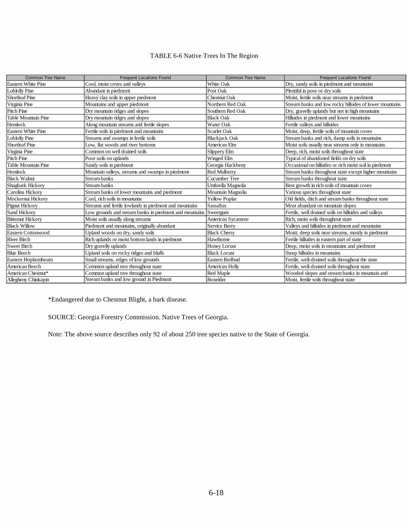
Major Forest Types and Vegetation
Table 6-5 provides a general overview of the major forest types based on ranges ofelevation in White County. Table 6-6 also offers a listing of 60 tree species, which are native toGeorgia and found in the mountain and piedmont areas. The various tree species listed in Table6-6.
TABLE 6-5 GeneralForest Types By
Elevation
FOREST TYPE LOCALE APPROXIMATE ELEVATIONRANGE
Oak RidgeOpen Oak-Pine
MixedDeciduous
Along crests of Blue Ridge Exposedsouth or north-facing slopes Moistvalley floors Dry ridge slopes ofPiedmont
3600' -4000'2100'-3800'
1800'-
SOURCE: Institute of Community and Area Development, University of Georgia. The Atlasof Georgia.
6-18
TABLE 6-6 Native Trees In The Region
*Endangered due to Chestnut Blight, a bark disease.
SOURCE: Georgia Forestry Commission. Native Trees of Georgia.
Note: The above source describes only 92 of about 250 tree species native to the State of Georgia.
Common Tree Name Frequent Locations Found Common Tree Name Frequent Locations Found
Eastern White Pine Cool, moist coves and valleys White Oak Dry, sandy soils in piedmont and mountains
Loblolly Pine Abundant in piedmont Post Oak Plentiful in poor or dry soilsShortleaf Pine Heavy clay soils in upper piedmont Chestnut Oak Moist, fertile soils near streams in piedmont
Virginia Pine Mountains and upper piedmont Northern Red Oak Stream banks and low rocky hillsides of lower mountainsPitch Pine Dry mountain ridges and slopes Southern Red Oak Dry, gravelly uplands but not in high mountainsTable Mountain Pine Dry mountain ridges and slopes Black Oak Hillsides in piedmont and lower mountains
Hemlock Along mountain streams and fertile slopes Water Oak Fertile valleys and hillsidesEastern White Pine Fertile soils in piedmont and mountains Scarlet Oak Moist, deep, fertile soils of mountain coves
Loblolly Pine Streams and swamps in fertile soils Blackjack Oak Stream banks and rich, damp soils in mountainsShortleaf Pine Low, flat woods and river bottoms American Elm Moist soils usually near streams only in mountainsVirginia Pine Common on well drained soils Slippery Elm Deep, rich, moist soils throughout state
Pitch Pine Poor soils on uplands Winged Elm Typical of abandoned fields on dry soilsTable Mountain Pine Sandy soils in piedmont Georgia Hackbeny Occasional on hillsides or rich moist soil in piedmont
Hemlock Mountain valleys, streams and swamps in piedmont Red Mulberry Stream banks throughout state except higher mountainsBlack Walnut Stream banks Cucumber Tree Stream banks throughout state
Shagbark Hickory Stream banks Umbrella Magnolia Best growth in rich soils of mountain covesCarolina Hickory Stream banks of lower mountains and piedmont Mountain Magnolia Various species throughout stateMockernut Hickory Cool, rich soils in mountains Yellow Poplar Old fields, ditch and stream banks throughout state
Pignut Hickory Streams and fertile lowlands in piedmont and mountains Sassafras Most abundant on mountain slopesSand Hickory Low grounds and stream banks in piedmont and mountains Sweetgum Fertile, well drained soils on hillsides and valleys
Bittemut Hickory Moist soils usually along streams American Sycamore Rich, moist soils throughout stateBlack Willow Piedmont and mountains, originally abundant Service Berry Valleys and hillsides in piedmont and mountains
Eastern Cottonwood Upland woods on dry, sandy soils Black Cherry Moist, deep soils near streams, mostly in piedmontRiver Birch Rich uplands or moist bottom lands in piedmont Hawthorne Fertile hillsides in eastern part of stateSweet Birch Dry gravelly uplands Honey Locust Deep, moist soils in mountains and piedmont
Blue Beech Upland soils on rocky ridges and bluffs Black Locust Steep hillsides in mountainsEastern Hophombeam Small streams, edges of low grounds Eastern Redbud Fertile, well-drained soils throughout the state
American Beech Common upland tree throughout state American Holly Fertile, well-drained soils throughout stateAmerican Chestnut* Common upland tree throughout state Red Maple Wooded slopes and stream banks in mountain andAllegheny Chinkapin Stream banks and low ground in Piedmont Boxelder Moist, fertile soils throughout state
6-19
The mountain areas of steep and moderately steep slopes tend to be somewhat drybecause of the high degree of water run-off due to a very short standing time in whichwater can be absorbed. The mountains were once covered by deciduous forest standsexisting in a condition known as "climax forests," typified by a high deciduous leafcanopy with little or no undergrowth. These original forest stands have almost completelydisappeared due to clear-cutting for commercial timber purposes. This clear cutting hascaused the highland slopes to become drier and encouraged more drought-resistant treesto cover the area. The American Chestnut species once filled the mountain region but hasnow all but disappeared due to drought and blight. Among the tree species now found onthese drier, steep slopes are: Pitch Pine, Table Mountain Pine, Allegheny Chinkapin, PostOak, Chestnut Oak, Scarlet Oak, and Blackjack Oak.
Areas of moderate and lower slopes receive various degrees of sunlight throughthe day and vary between warm and cool temperatures with moderate to slightly moistsoil conditions. In these areas, the Red Maple, Blue Beech, Sweetgum, Black Oak, andcertain species of pines, among others, are common.
The lower slopes receive more direct and intense sunlight and tend to containupland water flowing into the area. These areas sustain a wide variety of tree specieslisted in Table 6-6 as well as many types of ferns.
The lowest lying areas along stream banks and within floodplains generally remainwet or moist year round and support Hickory, Black Willow, Eastern Cottonwood, RiverBirch, Sweet Birch, American Beech, Elms, Magnolias, American Sycamore, White Ash,and other tree types as indicated in Table 6-6.
Major Park, Recreation, and Conservation Areas
Chattahoochee National Forest
According to the United States Forest Service, there are 41,276 acres (64.5 squaremiles) of land that is managed by the Chattahoochee National Forest in White County.The Chattahoochee National Forest’s land holdings encompass 26-5 percent of the total243 square miles in White County.
The National Forest land is located in the northern half of the County. With such alarge amount of land under national ownership and management, a detailed description ofthe Chattahoochee National Forest and the policies of the United States Forest Service iswarranted.
The Chattahoochee National Forest encompasses a total of 749,689 acres (1,171square miles) in northern Georgia and attracts many visitors each year due to its mountainvistas, whitewater streams and scenic landscapes. In addition to its recreationalopportunities, the Chattahoochee National Forest has valuable resources of timber, fuelwood, and minerals.

6-20
The Chattahoochee National Forest as a whole is comprised mostly of covehardwoods and upland hardwoods forest types, dominated by tree stands aged 40 to 80years. Major tree species include white and red oak, hickory, yellow poplar, shortleafpine, Virginia pine, and eastern white pine. Table 6-7 provides habitat information for theChestatee and Chattahoochee Wildlife Management Areas.
TABLE 6-7 Wildlife ManagementAreas Habitat Information By
Percentage (In % of Land Within
Wildlife Management Area)
TYPE OF HABITAT CHESTATEE CHATTAHOOCHEE
Upland hardwood 55% 54%
Yellow pine 13% 18%White pine 6% 13%Mixed pine-hardwood 5% 4%Mixed hardwood-pine 5% 3%Cove hardwood 9% 5%Regeneration (cut-over) areas 7% 3%Wildlife openings 41 acres 44 acres
TOTAL 100% 100%
SOURCE: United States Department of Agriculture, Forest Service, And SouthernRegion.
Over 500 species of wildlife are known to exist in the Chattahoochee and OconeeNational Forests, including major game such as deer, turkey, squirrel, grouse, quail,raccoon, fox, dove, woodcock and bear. Table 6-8 provides game population data for theChestatee and Chattahoochee Wildlife Management Areas.
TABLE 6-8 WildlifeManagement Areas Game
Populations (In Number of
Animals Per Acre/SquareMile)
SOURCE: United States Department of Agriculture, Forest Service, And SouthernRegion.* Data for 2001: Chattahoochee National Forest Management Indicator SpeciesPopulation and Habitat; 2003.
The Chattahoochee National Forest contains numerous trout streams that support
Type of Game Chestatee Chattahoochee
Deer 21/square mile 15/square mile
Dove 2/square mile 2/square mile
Ducks Negligable Negligable
Grouse 15/square mile 15/square mile
Quail 1/100 acres 1/100 acres
Rabbit 1/30 acres 1/30 acres
Squirrel 1/3 acres 1/3 acres
Turkey 5/square mile 10/square mile
Bear 1/2 square mile 1/1.5 square mile

6-21
wild populations of brook, brown and rainbow trout. There are 19,352 acres of publiclakes in the Chattahoochee National Forest. Significant trout streams located in WhiteCounty are Smith Creek, Chattahoochee River, Dukes Creek, Towns Creek, and TesnateeCreek. To help maintain fishing quality, many streams within the forest are stocked withhatchery-reared fish.
Recreation areas and sites are composed of "dispersed" recreation (hiking,camping, picnicking, fishing, hunting and riding) and "developed" recreation (camping,picnicking, swimming and boating). A description of major recreational areas within theChattahoochee National Forest is listed below and land areas are identified in Table 6-9.
Appalachian Trail- The Appalachian Trail runs 79.5 miles through the state ofGeorgia, from its beginning (or ending) point at Springer Mountain to the NorthCarolina state line near Tate City, Georgia. In all, the Appalachian Trail is 2,170miles in length, and was conceived by Benton McKaye and constructed with thehelp of the Civilian Conservation Corps and the Forest Service. Today, the trail ismaintained by a group of volunteers and clubs that is organized by theAppalachian Conference. The Appalachian Trail became the first national scenictrail authorized by Congress in 1968.
Raven Cliffs Wilderness- This area was designated a wilderness in 1986, andcovers a total of 9,115 acres. The area is known for its many streams, hardwoodforests, and waterfalls and mountainous terrain. Elevations range from 1,800 feetto 3,846 feet. Raven Cliffs Wilderness provides 41 miles of trout streams, andhabitat for deer, black bear, grouse, turkey, other species. The Appalachian Trailfollows the highest ridges for 6-6 miles through the Wilderness, and the 2.6-mileRaven Cliffs Falls Trail is also located within the area. Surrounding Raven CliffsWilderness is the Chestatee and Chattahoochee Wildlife Management Areas.
Tray Mountain Wilderness- Tray Mountain Wilderness is a 9,700 acre tract thatwas established in 1986. The area contains forests that are 60 years or older,mountains that reach up to 4,430 feet (Tray Mountain), 41 miles of trout streams,and 16-5 miles of the Appalachian Trail.
Mark Trail Wilderness- Created in 1991, the Mark Trail Wilderness totals 16,880acres. The area is home to 65 miles of trout streams that provide habitat forrainbow, brown, and brook trout. Horsetrough Mountain is the highest peak in theWilderness, and stands at 4045 feet. The Appalachian Trail follows the highridges that make up the northern and western edges of White County for 14 miles.
Anna Ruby Falls- This 1,600 acre area is located northeast of Helen, and is famousfor its double waterfall that is created from Curtis and York Creeks. Curtis andYork Creeks begin on the slopes of Tray Mountain before cascading down the 153and 50 foot drops, respectively, that compose Anna Ruby Falls. From theconfluence of the two streams at the falls, Smith Creek then flows into UnicoiLake, and later into the Chattahoochee River.
Unicoi State Park- Unicoi State Park is located northeast of the City of Helen, and
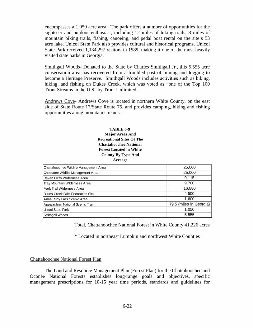
6-22
encompasses a 1,050 acre area. The park offers a number of opportunities for thesightseer and outdoor enthusiast, including 12 miles of hiking trails, 8 miles ofmountain biking trails, fishing, canoeing, and pedal boat rental on the site’s 53acre lake. Unicoi State Park also provides cultural and historical programs. UnicoiState Park received 1,134,297 visitors in 1989, making it one of the most heavilyvisited state parks in Georgia.
Smithgall Woods- Donated to the State by Charles Smithgall Jr., this 5,555 acreconservation area has recovered from a troubled past of mining and logging tobecome a Heritage Preserve. Smithgall Woods includes activities such as biking,hiking, and fishing on Dukes Creek, which was voted as “one of the Top 100Trout Streams in the U.S” by Trout Unlimited.
Andrews Cove- Andrews Cove is located in northern White County, on the eastside of State Route 17/State Route 75, and provides camping, hiking and fishingopportunities along mountain streams.
TABLE 6-9Major Areas And
Recreational Sites Of The
Chattahoochee NationalForest Located in White
County By Type And
Acreage
Total, Chattahoochee National Forest in White County 41,226 acres
* Located in northeast Lumpkin and northwest White Counties
Chattahoochee National Forest Plan
The Land and Resource Management Plan (Forest Plan) for the Chattahoochee andOconee National Forests establishes long-range goals and objectives, specificmanagement prescriptions for 10-15 year time periods, standards and guidelines for
Chattahoochee Wildlife Management Area 25,000
Chestatee Wildlife Management Area* 25,000
Raven Cliffs Wilderness Area 9,115
Tray Mountain Wilderness Area 9,700
Mark Trail Wilderness Area 16,880
Dukes Creek Falls Recreation Site 4,500
Anna Ruby Falls Scenic Area 1,600
Appalachian National Scenic Trail 79.5 (miles in Georgia)
Unicoi State Park 1,050
Smithgall Woods 5,555
6-23
management, and monitoring procedures to assure plan implementation. The Forest Planshould be referenced for information relating to the management of National Forest Landswithin White County (source: United States Department of Agriculture, Forest Service,Southern Region. Land and Resource Management Plan, Chattahoochee and OconeeNational Forests. (Revised January 2004).
Water Resources
Surface water resources include the water in rivers, smaller streams, lakes, pondsand man-made reservoirs. Rivers within the Blue Ridge physiographic province generallyhave small drainage areas but relatively high water yields. The rivers in this province havesteep, rocky channels and flow swiftly over many rapids and waterfalls. The mostimportant surface water resource in White County is the Chattahoochee River, or "river ofthe painted rocks."
The Chattahoochee River originates in the Blue Ridge Mountains just above WhiteCounty and flows in a southerly direction through the Piedmont and Coastal Plain. It isthe longest river in Georgia - 436 miles from its source in northeastern Georgia to theFlorida line. The drainage area of the Chattahoochee River in the Georgia Mountainsregion is 1,179 square miles, including all of White County and portions of Hall,Habersham, Lumpkin, Dawson and Forsyth Counties. Smaller tributaries to theChattahoochee River in the region include Dukes Creek, and Smith, Sautee, and BlueCreeks. The river is dammed to form Lake Lanier south of Gainesville, the first of severalimpoundments on the river. Below Buford Dam, the Chattahoochee is very heavily usedby local governments in the Atlanta region, and supplies 70 percent of metropolitanAtlanta’s water needs and over half of the State's residents. The Chattahoochee River isthus a major water resource not only to White County, but the region, State of Georgiaand other states as well.
In the headwater region in the Blue Ridge physiographic province, theChattahoochee River and its tributaries provide recreational opportunities, but are lightlyused as sources of water for municipal and industrial facilities. The Upper ChattahoocheeRiver Basin is typified by small streams as well as limited groundwater, making itsphysical capability for water use quite limited.
Small communities in the upper basin often use groundwater wells, surface watersupplies, or a combination. The crystalline rock underlying this area greatly limitsgroundwater availability.
Groundwater in the upper Chattahoochee River Basin is supplied by theCrystalline Rock Aquifer System, which consists of a complex of igneous andmetamorphic rocks that have been folded and fractured. Groundwater occurs in thefractures in the rocks as well as in the pore spaces in the overlying soil, which was derivedfrom the weathering of underlying rocks. Well yields in this aquifer range from one tomore than 200 gallons per minute. Water can be found from depths of ten to more than400 feet. Recharge in the aquifer system is localized.

6-24
Water Quality
The overall water quality of the Chattahoochee River in White County is verygood. There is a significant number of headwater tributaries classified as primary orsecondary streams. In the early 1980s, a dramatic increase in the level of tourism in theCity of Helen resulted in discharges from the Helen Water Pollution Control Plant inexcess of its permit limitation. The problem of hydraulic overloading has since then beendecreased by placement of chemical toilets in public use areas, an upgrading of the HelenWater Pollution Control Plant, and construction of a land application system. Despite theefforts that have been made, some problems can occur. The Chattahoochee River BasinWatershed Protection Plan specifically identifies the headwaters of the ChattahoocheeRiver as susceptible to sediment contamination associated with development on steepslopes. The study also found that the headwaters of the Chattahoochee are susceptible tonon-point sources of pollution including metals, fecal coliform bacteria, erosion andsedimentation, and nutrient loading (Source: Chattahoochee River Basin WatershedProtection Plan 1997).
Water Resources Management
As mentioned previously, White County lies within the Upper ChattahoocheeRiver Soil and Water Conservation District. In addition, White County lies within theChestatee-Chattahoochee Resource Conservation and Development Area, which wasestablished in 1971. The Resource Conservation and Development Areas are localprojects in which residents work to improve their economy and the environment throughconservation, development, and better utilization of natural resources. Various otheragencies such as the U.S. Army Corps of Engineers and the Georgia Department ofNatural Resources play major roles in the management and conservation of naturalresources in White County.
Public Water Supply Sources
The White County Water Authority is the largest public water provider for theCounty, and serves approximately 1,400 people in White County. The system contains 72miles of main line, which follows the major roadways in the county including routes 129,75, Alt 75, and 115, and provides water to adjacent developments. The system containstwo storage tanks of 500,000 gallons and 300,000 gallons. White County WaterAuthority acquires its water from the Turner Creek surface water intake. Waterwithdrawal from Turner Creek is 1.8 Million Gallons per Day (MGD). The Departmentof Natural Resources places special requirements on the areas surrounding a surface waterintake. This information is discussed in the Water Supply Watershed section.
Expansion of the White County Water Authority is anticipated in the future tomeet the needs of its expanding customer base. The Authority will continue to installlines throughout White County, it is estimated that new storage tanks will be needed in thenext 3 to 5 years, and groundwater wells may be installed to increase water capacities inthe future.
The cities of Helen and Cleveland use groundwater wells as their water supplysources. Groundwater storage occurs when precipitation infiltrates into the soil. In northGeorgia, groundwater supplies come from either shallow regolith (unconsolidated soils)

6-25
or the crystalline rock aquifer. Shallow regolith stores water in its pore spaces and has thecapacity to receive and accumulate enough water to supply small, single family wells.These shallow wells do not have the yield capacity to sustain municipal water demands,are susceptible to contamination, and should not be used for public water supplies. Thedeeper crystalline rock aquifers are found throughout the Piedmont and Blue Ridge andhave variable yields. Well productivity depends on the on the location and depth of theborehole in relation to fractures in the crystalline bedrock. Because water is transferredand stored in bedrock fractures, a productive well’s borehole must cross a combination ofeither a number of small fractures, or a single large fracture. Determining the location ofthese fractures is exceptionally difficult. Cleveland and Helen both use groundwater wellsthat tap into the crystalline rock aquifer as their water supply sources. The City of Helenutilizes four wells, which have an average withdrawal rate of .350 Million Gallons perDay (MGD). The City of Helen recently renewed their permit with Georgia EPD. TheCity of Cleveland employs four wells that have a withdrawal permit for .841 MGD. Theaverage daily withdrawal for the city is .450 MGD. The renewal date Cleveland’s permitis June 15, 2013.
Waste Water Facilities
The majority of White County uses septic systems for wastewater treatment, withthe exception of the Cities of Cleveland and Helen, which are served by sewer systems.
Properly functioning septic systems are necessary for public health and welfare.The majority of soils found in White County are classified as having severe limitations forseptic systems. Steep slopes are the prominent limiting factor for septic systems in theCounty. Areas of steep slopes are defined as any slope with an angle of 25 percent orgreater. The Department of Human Resources discourages the use of septic tanks onslopes greater than 35 percent. Many developments in White County are currentlyplatted, if not already developed, on steep slopes. Low and moderate densityneighborhoods have been developed throughout unincorporated White County, many ofwhich are located on the previously mentioned steep slopes. Proper functioning septicsystems require drain fields of varying sizes depending on the soil and slopecharacteristics.
While high-density development and development on steep slopes can occur, themaintenance of a quality septic system is essential for the public well-being. It isrecommended that basic regulations regard the limitations of septic systems throughoutWhite County.
Water Supply Watersheds
White County has adopted a Water Supply Watershed Ordinance that is intended,among other purposes, to protect areas of land upstream from governmentally ownedpublic drinking water intakes and water supply reservoirs through adoption of watershedprotection plans. This section briefly describes the county's water supply watershedordinance; however, the ordinance should be referenced for any development activity.
Water supply intakes and their watersheds, as defined by the DNR, was obtained

6-26
in part from DNR’s Water Supply Watershed Maps (Map 6-4). The only existing publicsurface water intake in White County is located on Turner Creek, which has a drainagearea of 8.3 square miles. This facility is managed by the White County Water and SewerAuthority, and has a permitted capacity of 1.8 million gallons a day (MGD). The TurnerCreek watershed constitutes a "small" watershed according to the "Part V" standards,because it is less than 100 square miles in area. The perennial streams within the TurnerCreek Watershed include Turner Creek, Cathey Creek, Tom White Branch, and LedfordBranch. Lake Qualatchee is also included within the Turner Creek water supplywatershed area.
Watershed Protection for Tuner Creek Water Supply Watershed
- A buffer shall be maintained for a distance of one hundred (100) feet on bothsides of the stream as measured from the stream Banks
- No impervious surface shall be constructed within a one hundred fifty (150) footsetback area on both sides of the stream as measured from the stream banks
- Septic tanks and septic tank drain fields are prohibited in the setback area of 2)above.
- Hazardous waste treatment or disposal facilities are prohibited in the WatershedProtected area, including, but not limited to hazardous materials of the types listedin Section 312 of the Resource Conservation and Recovery Act of 1976
-Only land-disturbing activities that are permitted by this resolution and areapproved by the White County Planning Commission through use of BestManagement Practices or that have an approved Erosion and SedimentationControl Plan from the Upper Chattahoochee Soil and Water Conservation Districtwill be allowed within the watershed drainage area of the intake
-All permitted and acceptable land disturbing activities will be properly vegetatedor re-vegetated immediately with appropriate grasses or legumes.
-No sanitary landfills, hazardous waste treatment or disposal facilities will beallowed in the watershed drainage area.
- Harvesting of forest products will be performed in accordance with aharvesting plan agreed to by the Georgia State Forestry Commission and anErosion and Sediment Control Plan approved by the Upper ChattahoocheeSoil and Water Conservation District.
-Forestry management within the watershed drainage area will follow theGeorgia State Forestry Commission's Best Management Practices Guidelinesfor Streamside Management Zones, Stream Crossings, Access Road andTheir Construction, Timber Harvesting, Site Preparation, Reforestation andForest Protection (Prescribed Burning, Firelines, and Chemical FireRetardant).
6-27
- No new land application of animal or poultry waste will be allowed withoutapproved nutrient management plan. Such plan will be prepared by either theNatural Resource Conservation Services or UGA Cooperative Extension Service.
- Broad use of chemical agents such as pesticides areprohibited within the buffer.
- Fires or burning on the stream banks are not authorized.
- No new industrial development will be allowed in the Watershed drainagearea. New commercial developments shall be restricted to a 25%impervious surface area and a lot size minimum of five (5) acres within theWatershed drainage area.
- It shall be the responsibility of every land owner, developer or builder tosubmit plans for land use alterations within the watershed drainage area tothe White County Planning Commission for approval.
-The impervious surface area, including all public and private structures, utilities,or other facilities, of the entire water supply watershed shall be limited to twenty-five (25) percent or existing use, whichever is greater.
A large water supply watershed (drainage area of 100 sq/mi or greater)necessitates different management strategies than small watersheds such as the TurnerCreek watershed. White County has developed different standards for the protection ofthese large watersheds, which follows the recommendations established by the DNR forthe protection of large water supply watersheds. The City of Baldwin operates a waterintake that is located on the Chattahoochee River, immediately downstream from theconfluence with the Soque River. The intake drains approximately 316 square milesupstream of the intake and is therefore classified as a large water supply watershed. Themajority of northern and eastern White County falls within the management of this watersupply watershed protection area. Within this area, hazard waste facilities are prohibited.
Neither the City of Cleveland or the City of Helen lie within a protected waterssupply watershed that require additional water protection standards than the stateminimum for water quality protection.

6-28
Map 6-4

6-29
Flood Plains
Flood Plains are the areas along streams that are normally dry, but becomecovered with water during flood conditions. Although all streams occasionally becomeflooded, the condition of a stream’s watershed is a major influence on the magnitude ofthe flooding. Activities such as logging or development may increase the possibility offlooding downstream of the disturbance. Structures erected within the floodplain are atrisk of damage during floods. Similarly, they change the pattern of water flow and canincrease flooding and damage on adjacent property. Besides being a storage area forexcess floodwater, floodplains are important habitat areas and perform a critical role as anarea of filtration for water entering into the mainstream channel (SOURCE: “Floods andFlood Plains”, USGS, 1993).
The National Flood Insurance Program, which is administered through FEMA,offers flood hazard insurance to residents that reside in communities that have adoptedfloodplain management ordinances. These ordinances include corrective and preventativemeasures to minimize the safety and economic costs associated with flooding and includezoning, subdivision, and building requirements. Unincorporated White County,Cleveland, and Helen are all members of the National Flood Insurance Program.
Flood hazard mapping is performed through the National Flood InsuranceProgram. These Flood Insurance Rate Maps (FIRMS) are used to identify areas of floodhazard. Map 6-5 identifies several surface waters in White County are known to containflood hazard areas, including the Chattahoochee River, Dukes Creek, Bean Creek,Chickamauga Creek, Cathey Creek, Tesnatee Creek, Turner Creek, Mossy Creek, FlatCreek, Shoal Creek, and White Creek. While the National Flood Insurance Programoffers a level of protection from flood hazards, all of these areas should continuously bemonitored to ensure proper protection from flood hazards. The City of Helen isparticularly at risk from flood hazards because the majority of the city lies within theflood plain. Much of the tourist related development are located within the flood plain.Any development that occurs in these areas requires engineered no-rise certification to beapproved by the U. S Army Corp of Engineers.
River Corridor ProtectionThe river corridor is essential to maintain the proper functioning of a stream and
its associated natural environments. The river corridor serves as a filtration system forstorm water entering into the stream, an area to store excess floodwaters, and habitat fornumerous plant and animal species. These areas also serve as significant educational,scenic, and recreational opportunities.
The Department of Natural Resources (DNR) has established criteria for rivercorridor protection. Based on the criteria for river corridor protection, White County hasdesignated the Chattahoochee River from Smith Island downstream to Hall County as aprotected river corridor, as shown in Map 6-6. The following section provides a summaryof the river corridor protection ordinance for White County.

6-30
River corridor protection measures:
- A one hundred (100) ft. natural vegetative buffer shall be maintained atall times within the protected river corridor except as otherwise providedherein.
- Septic tanks and septic tank drainfields are prohibited within the rivercorridor, except as provided in Section 4.1 (d) of this ordinance.
- The natural vegetative buffer shall be restored as quickly as possiblefollowing any land-disturbing activity within the river corridor.
The ordinance also identifies a number of prohibited activities within the corridor,which include:
- Hazardous waste or solid waste landfills, or construction and demolition(C&D) landfills.
- Commercial or industrial uses that involve handling hazardous materialsother than wastes.
- Handling area for the receiving and storage or hazardous waste.
- Construction within the river corridor is prohibited unless specificallyidentified as a permitted activity.

6-31
Map 6-5

6-32
Map 6-6

6-33
Groundwater Recharge Areas
In the Piedmont and Blue Ridge geologic province, rocks have little porosity, withmost groundwater being stored in the overlying soils. The significant recharge areasoverly locations with thick soils (a density of two or more geologic contacts per foursquare miles, and slopes lower than 8%). The significant recharge areas have beenmapped by the Georgia Department of Natural Resources in Hydrologic Atlas 18 (1989edition), and are illustrated in map 6-7. The DNR's determination of significant rechargeareas indicates that there are only two such areas in White County: an area west of MountYonah, and an area southeast of Cleveland.
White County has developed a ground water protection ordinance for significantrecharge areas, which includes both a site plan requirement for locations in thegroundwater recharge area and additional protection standards for development of theseareas. This groundwater recharge ordinance satisfies DNR's criteria for groundwaterrecharge protection.
The site plan requirements are summarized below:
- A map or maps, drawn to scale of 1 inch = 100 feet or other approved scale,showing all planned improvements including the width, depth and length ofall existing and proposed structures, roads, water courses and drainage ways,water lines, wastewater and storm water facilities, and utility installations,shall be provided by the applicant.
- Location, dimensions and area of all impervious surfaces, both existing andproposed, on the site.
- The orientation and distance from the boundaries of the proposed site to thenearest bank of an affected perennial stream of water body. Delineation ofall defined or suspected wetlands, if applicable, should be included.
- Elevations of the site and adjacent lands within 200 feet of the site atcontour intervals of no greater than ten (10) feet.
- All proposed temporary disruptions or diversions of local hydrology.
- A map of all planned land disturbance activity shall bear the signature/sealof a registered or certified professional in engineering, architecture,landscape architecture, land surveying, or erosion and sedimentation control,or a County Surveyor, and shall conform to current guidelines as set forth inthe Erosion and Sediment Control Ordinance of 1975 as amended.
- Activities to comply with site plan. All development activities or site workconducted after approval of the site plan shall conform with thespecifications of said site plan. Significant changes to the site plan thatwould alter the amount and velocity of storm-water runoff from the site,increase the amount of impervious surface within the development, alter the

6-34
overall density of development, result in a considerable increase in theamount of excavation, fill or removal of vegetation during construction orotherwise result in an alteration of the overall appearance of the developmentas proposed, can be amended only with the approval of White County.Minor changes, such as the realignment of streets or minor alterations todrainage structures and other infrastructure to meet unexpected conditionsare exempted from this requirement.
The protection standards for groundwater recharge areas include:
- For all pollution susceptibility areas, new waste disposal facilities musthave synthetic liners and leachate collection systems.
- New agricultural impoundments shall meet the followings requirements:
- For areas of high susceptibility, a liner shall be constructed that is, at aminimum, of compacted clay having a thickness of one-foot and a verticalhydraulic conductivity of less than 5 X 10⁻⁷ cm/sec or other criteriaestablished by the Natural Resources Conservation Service.
- For areas of medium susceptibility, an NRCS approved liner, as describedin 5.2.1, shall be provided if the site exceeds 15 acre-feet.
- For areas of low susceptibility, a NRCS approved liner, as described inSection 5.2.1, shall be provided if the site exceeds 50 acre-feet.
- No land disposal of hazardous waste shall be permitted within anySignificant Groundwater Recharge Area.
- For all Significant Groundwater Recharge Areas, the handling, storage anddisposal of hazardous materials, as listed in Section 312 of the ResourceConservation and Recovery Act of 1976,( excluding underground storagetanks) and in the amounts of 10,000 pounds or more on any one day, shalltake place on an impermeable surface having spill and leak protectionapproved by the Georgia Department of Natural Resources, EnvironmentalProtection Division (EPD), and conforming to local fire prevention coderequirements.
- For all Significant Groundwater Recharge Areas, new above groundchemical or petroleum storage tanks having a minimum volume of 660gallons must have secondary containment for 110 percent of tank volume or110 percent of the largest tanks in a cluster of tanks. Such tanks used foragricultural purposes are exempt, provided they comply with all federalrequirements.
- For all Pollution Susceptibility Areas, new wastewater treatment basinsshall have an impermeable liner approved by EPD.

6-35
- For all Pollution Susceptibility Areas, no new storm water infiltrationbasins may be constructed.
- For all Pollution Susceptibility Areas, wastewater spray irrigation systemsof land spreading of wastewater sludge shall be practiced in accordance withDepartment of Natural Resources criteria for slow rate land treatment withamendments and technical publications to site specific information submittedby a registered professional engineer. An application for a new developmentpermit for activities involving wastewater spray irrigation or land spreadingof wastewater sludge must be accompanied by proof that the applicant hasreceived a Land Application System permit from EPD.
- Minimum lot sizes and septic systems- No construction may proceed on abuilding or mobile home to be served by septic tank unless the White CountyHealth Department first approves the proposed septic tank installations asmeeting the requirements of the Georgia Department of Human Resource forOn-site Sewage Management (hereinafter DHR) Manual, and the followingrequirements:
- New homes served by a septic tank/drainfield system shall be on lotshaving a minimum size limitations as follows:
A) 150% of the subdivision minimum lot size calculated basedon application of DHR Table MT-1 if they are within a highpollution susceptibility area;
B) 125% of the subdivision minimum lot size calculated basedon application of DHR Table MT-1 if they are within amedium pollution susceptibility area;
C) 110% of the subdivision minimum lot size calculated basedon application of DHR Table MT-1 if they are within a lowpollution susceptibility area.
- New mobile home parks served by septic tank/drainfield systems shall havelots or spaces having minimum size limitations as follows:
A) 150% of the subdivision minimum lot or space sizecalculated based on application of DHR Table MT-2 if theyare within a high pollution susceptibility area;
B) 125% of the subdivision minimum lot or space sizecalculated based on application of DHR Table MT-2 if theyare within a medium pollution susceptibility area;
C) 110% of the subdivision minimum lot or space sizecalculated based on application of DHR Table Mt-2 if theyare within a low pollution susceptibility area.

6-36
Map 6-7

6-37
Wetlands
The United States Congress enacted the Clean Water Act to protect the nation'srivers, streams, estuaries, seas, ponds, lakes and wetlands. The term wetlands includesswamps, marshes, bogs and similar areas. The United States Army Corps of Engineersand the United States Environmental Protection Agency formally define wetlands as"those areas that are inundated or saturated by surface or groundwater at a frequency andduration sufficient to support, and that under normal circumstances do support, aprevalence of vegetation typically adapted for life in saturated soil conditions." TheGeorgia Department of Natural Resources '"Part V" standards have adopted thisdefinition.
Wetlands serve many functions and have a number of values. In their naturalcondition, wetlands temporarily store floodwaters, thereby preventing flood damage.Wetlands can also protect lands from erosion by reducing the velocity of water currents.Many wetlands are areas of groundwater discharge, and some wetlands may providesufficient quantities of water for public use. A variety of natural products are produced inwetlands, including timber and fish and wildlife. Wetlands also have importantenvironmental quality values such as improving water quality by intercepting stormwaterrun-off, preventing eutrophication of natural waters, and by supporting delicate aquaticecosystems (nutrient retention and removal, food chain support, migratory waterfowlusage, etc).
Wetlands can be generally identified by analyzing vegetation, hydrology, and soilscommon to wetlands. The soils that occur in wetlands, called hydric soils, havecharacteristics developed under conditions where soil oxygen is limited by watersaturation for long periods in the growing season. Hydric soils typically have thefollowing characteristics: 1) they consist of decomposed plant materials (peats andmucks); 2) have a thick layer (8 inches or more) of decomposing plant material onsurface; 3) a bluish gray or gray color at 10 to 12 inches below the surface; and 4) theodor of rotten eggs.
Classification of Wetlands
The Georgia Department of Natural Resources has classified wetlands into thefollowing categories:
1. Open water - areas of open water, primarily reservoirs, ponds, lakes, rivers andestuaries.
2. Non-forested emergent wetlands - freshwater marshes dominated by a varietyof grasses, sedges, rushes, and broadleaved aquatics associated with streams,ponded areas, and tidally-influenced non-saline waters.
3. Scrub/shrub wetlands- non-forested areas dominated by woody shrubs,seedlings, and saplings averaging less than 20 feet in height; these wetlandsmay integrate with forested wetlands, non-forested emergent wetlands, andopen water.

6-38
4. Forested wetlands - natural or planted forested areas having a dominant treecrown closure of hardwoods, pines, gums, cypress, or any combination ofthese types. These areas are usually in stream or river floodplains, isolateddepressions, and drainways, and contain standing or flowing water for aportion of the year. Sub-categories:
1. Hardwood floodplain forests2. Coniferous floodplain forests3. Mixed floodplain forests4. Non-alluvial forested wetlands.
5. Altered wetlands - areas with hydric soils that have been denuded of naturalvegetation and put to other uses, such as pasture, row crops, etc., but thatotherwise retain certain wetlands functions and values.
The National Wetlands inventory, developed by the U.S. Fish and WildlifeService, provides information on wetland locations throughout the nation. The NWI alsoprovides information on the status, extent, characteristics and functions of wetlands,riparian, deepwater and related aquatic habitats to promote the understanding andconservation of these resources. White County has been included in the NWI study.Findings show that the county is sporadically covered with small to moderate sizedwetlands (Map 6-5). The highest concentrations of large wetlands are located along asouthwest to northeast axis that stretches through the middle of the County. Total acreagefigures for hydric soils are indicated in Table 6-3.
For the actual determination of wetlands on specific sites, the Federal Manual ForIdentifying and Delineating Jurisdictional Wetlands (U.S. Army Corps of Engineers,January 10,1989) as well as a competent wetlands expert should be consulted.
Existence of Rare Wetlands
Certain wetlands represent particularly rare natural communities. The "mountainbog" is one notable example of a rare wetland. The mountainous areas in northern portionof the county generally have fewer wetlands than the lower elevations. Nonetheless,“mountain bogs” contain numerous rare or protected species, and some of the greatestspecies diversity of any habitat in Georgia.
Georgia's mountain bogs are very limited in both number and total acreage, andoccur at the heads of streams, along seepage slopes and near springs in the mountains ofNorth Georgia. They are characterized by acidic, peat-rich soils that are constantlysaturated with water. The vegetative cover of these bogs varies greatly. Sites commonlycontain shrubs, trees, or a diverse mixture of herbaceous species.
Rare species known to exist within mountain bogs include sheep laurel, northernpitcher plant, swamp-pink and the bog turtle. Other species typical of mountain bogsinclude blackgum, swamp azalea, alder, chokeberries, cinnamon fern, turtlehead andsphagnum mosses.

6-39
Only a few mountain bog sites are known. Because of their vulnerability todisturbance from activities such as ditching and drainage, livestock grazing and overcollection of rare plants, the long term existence of some of Georgia's mountain bogs arein serious jeopardy. There is a need to protect various vegetation types comprising thisbroad wetland category. (Source: Ambrose, Jon. 1990 (Winter.) "Rare Wetlands". GeorgiaDepartment of Natural Resources Outdoor Report. Volume 5, Number 1, pp. 6-7.)
Local Protection of Wetlands
In accordance with the DNR, White County has developed a wetlands protectionordinance as well as a general wetlands map. While the specific ordinance should bereferenced before any development activity is to take place, a summary of the wetlandsordinance is provided in the following paragraphs. The wetlands map is provided toidentify areas with a high likelihood of the presence of a wetland. The ordinance allowsthe Corps of Engineers to ultimately determine if the proposed project is located near orcontains a wetland. The wetlands ordinance further establishes a permit requirement fordevelopment activities that disturb wetlands, or come within 50 feet of a wetlandprotection district boundary. Eventually both Cleveland and Helen will need to adopt anordinance for the protection of wetlands as mandated by the state.
Prohibited uses within the protected wetlands district includes:
-No facilities for the handling, storage, and disposal of hazardous materials,toxic waste, or other contaminants shall be permitted within a WetlandProtection District.
-No hazardous or sanitary waste landfill shall be permitted within a WetlandsProtection District.
-Uses that are prohibited by other Ordinance or Resolution , of White County,are prohibited in a Wetlands Protection District.
Site plans are also necessary for development within the Generalized WetlandsProtection District. The requirements of the site plans include:
- A map of all planned land disturbance activity shall bear the signature/sealof a registered or certified professional in engineering, architecture, landscapearchitecture, land surveying, or erosion and sedimentation control or a CountySurveyor, and shall conform to current guidelines as set forth in the Erosionand Sediment Control Ordinances of 1975 as amended.
- Location, dimensions and area of all impervious surfaces, both existing andproposed, on the site.
- The orientation and distance from the boundaries of the proposed site to thenearest bank of an affected perennial stream or water body.

6-40
- Elevations of the site and adjacent lands within 200 feet of the site atcontour intervals of no greater than ten feet.
- Location and detailed design of any spill and leak collection systemsdesigned for the purpose of containing accidentally released hazardous ortoxic materials.
- All proposed temporary disruptions or diversions of local hydrology.
Federal Protection of Wetlands
Section 404 of the Clean Water Act regulates the discharge of dredged and fillmaterial into waters of the United States and establishes a permit program to ensure suchdischarges comply with environmental requirements. The U.S. Army Corps of Engineersand the U.S. Environmental Protection Agency administer the Section 404 program. AU.S. Army Corps of Engineers permit is required for such activities that involve thedischarge of soil into waters of the United States. If the discharge is predicted to have an"unacceptable adverse effect" on municipal water supplies, shellfish beds and fisheryareas, wildlife, or recreational areas, the Environmental Protection Agency may prohibitor restrict such discharges.
In addition to regulatory practices, the United States Environmental ProtectionAgency (EPA) has prepared a "Wetlands Action Plan" (January 1989) in response torecommendations of the National Wetlands Policy Forum. This plan, which is a short-term agenda, supports the goal "to achieve no overall net loss of the nation's remainingwetlands base, as defined by acreage and function; and to restore and create wetlands,where feasible, to increase the quality and quantity of the nation's wetlands resourcebase."
To implement this goal, EPA has established seven objectives, including: 1)technical support in state wetlands conservation plans; 2) mechanisms to enhance stateand local governments' wetlands protection efforts; 3) improvements in the Section 404regulatory program; 4) adoption of policies for mitigation of unavoidable wetlandimpacts; 5) increased information and education; 6) assess the cumulative impacts ofwetland loss and degradation; and 7) identify opportunities to restore and create wetlands.
Avoidance and minimization of impact is the primary objective of wetlandsmanagement. Local jurisdictions should institute whatever measures are possible to ensurethat wetland mitigation or replacement projects are a last resort and not used to justify thedestruction of wetlands. Table 6-10 provides a listing of typical wetland mitigationmeasures that can be applied in cases where alteration/impact of wetlands cannot becompletely avoided.
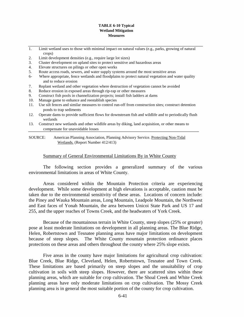
6-41
TABLE 6-10 Typical
Wetland Mitigation
Measures
1. Limit wetland uses to those with minimal impact on natural values (e.g., parks, growing of naturalcrops)
2. Limit development densities (e.g., require large lot sizes)3. Cluster development on upland sites to protect sensitive and hazardous areas4. Elevate structures on pilings or other open works5. Route access roads, sewers, and water supply systems around the most sensitive areas6- Where appropriate, fence wetlands and floodplains to protect natural vegetation and water quality
and to reduce erosion
7. Replant wetland and other vegetation where destruction of vegetation cannot be avoided8. Reduce erosion in exposed areas through rip-rap or other measures9. Construct fish pools in channelization projects; install fish ladders at dams10. Manage game to enhance and reestablish species11. Use silt fences and similar measures to control run-off from construction sites; construct detention
ponds to trap sediments
12. Operate dams to provide sufficient flows for downstream fish and wildlife and to periodically flushwetlands
13. Construct new wetlands and other wildlife areas by diking, land acquisition, or other means to
compensate for unavoidable losses
SOURCE: American Planning Association, Planning Advisory Service. Protecting Non-TidalWetlands. (Report Number 412/413)
Summary of General Environmental Limitations By in White County
The following section provides a generalized summary of the variousenvironmental limitations in areas of White County.
Areas considered within the Mountain Protection criteria are experiencingdevelopment. While some development at high elevations is acceptable, caution must betaken due to the environmental sensitivity of these areas. Locations of concern include:the Piney and Wauka Mountain areas, Long Mountain, Leadpole Mountain, the Northwestand East faces of Yonah Mountain, the area between Unicoi State Park and US 17 and255, and the upper reaches of Towns Creek, and the headwaters of York Creek.
Because of the mountainous terrain in White County, steep slopes (25% or greater)pose at least moderate limitations on development in all planning areas. The Blue Ridge,Helen, Robertstown and Tesnatee planning areas have major limitations on developmentbecause of steep slopes. The White County mountain protection ordinance placesprotections on these areas and others throughout the county where 25% slope exists.
Five areas in the county have major limitations for agricultural crop cultivation:Blue Creek, Blue Ridge, Cleveland, Helen, Robertstown, Tesnatee and Town Creek.These limitations are based primarily on steep slopes and the unsuitability of cropcultivation in soils with steep slopes. However, there are scattered sites within theseplanning areas, which are suitable for crop cultivation. The Shoal Creek and White Creekplanning areas have only moderate limitations on crop cultivation. The Mossy Creekplanning area is in general the most suitable portion of the county for crop cultivation.
6-42
Although scattered about in the northern one-third of the county, rock land androck outcrops pose relatively few limitations on development. The only planning area inwhich rock land and rock outcrops may have a moderate limitation on development iswithin the Tesnatee planning area.
Regarding soil suitability for septic tanks, the majority of the county has someserious type of limitations. It was noted previously that only 18% of the total County landarea is suitably ideal for septic tank utilization without substantial adjustments. Four areasin the county have soils with only moderate limitations on the use of septic tanks: MossyCreek, Mt. Yonah, Shoal Creek, and White Creek.
Wetlands pose moderate limitations throughout the except in Mossy Creek, wheremajor limitations are imposed due to the prevalence of hydric soils. Due to the abundanceof streams and rivers in White County, careful attention should be paid to theidentification of wetlands prior to development.
Flood plains exist in varying degrees within White County, Cleveland and inHelen. However, because they exist mostly within narrow valleys and stream corridors,flood plains are considered to pose only moderate limitations in four planning areas:Mossy Creek, Nacoochee, Shoal Creek, and Town Creek. The City of Helen is at risk themost due much of the city and development lying within the flood plain.
As mentioned previously, "significant" groundwater recharge areas are relativelyfew in White County. Although two such areas have been identified: one in the Mt. Yonaharea and a smaller site in Mossy Creek, groundwater recharge areas are anticipated to posefew limitations on development.
In summary, it can be said that the southern and centermost areas in the County(Cleveland, Mossy Creek, Mt. Yonah, Shoal Creek and White Creek) have the mostmoderate limitations on development, while the most mountainous planning areas (BlueRidge, Helen, Robertstown, and Tesnatee) have environmental characteristics which posethe most significant limitations on development.