Chapter II: User Capacity Management Program · Chapter II: User Capacity Management Program II-2...
52
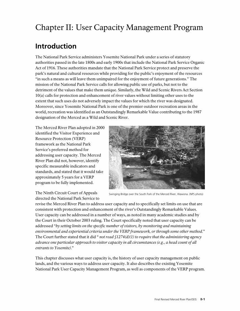
Final Revised Merced River Plan/SEIS II-1 Chapter II: User Capacity Management Program Introduction The National Park Service administers Yosemite National Park under a series of statutory authorities passed in the late 1800s and early 1900s that include the National Park Service Organic Act of 1916. These authorities mandate that the National Park Service protect and preserve the park’s natural and cultural resources while providing for the public’s enjoyment of the resources “in such a means as will leave them unimpaired for the enjoyment of future generations.” The mission of the National Park Service calls for allowing public use of parks, but not to the detriment of the values that make them unique. Similarly, the Wild and Scenic Rivers Act Section 10(a) calls for protection and enhancement of river values without limiting other uses to the extent that such uses do not adversely impact the values for which the river was designated. Moreover, since Yosemite National Park is one of the premier outdoor recreation areas in the world, recreation was identified as an Outstandingly Remarkable Value contributing to the 1987 designation of the Merced as a Wild and Scenic River. The Merced River Plan adopted in 2000 identified the Visitor Experience and Resource Protection (VERP) framework as the National Park Service’s preferred method for addressing user capacity. The Merced River Plan did not, however, identify specific measurable indicators and standards, and stated that it would take approximately 5 years for a VERP program to be fully implemented. The Ninth Circuit Court of Appeals directed the National Park Service to revise the Merced River Plan to address user capacity and to specifically set limits on use that are consistent with protection and enhancement of the river’s Outstandingly Remarkable Values. User capacity can be addressed in a number of ways, as noted in many academic studies and by the Court in their October 2003 ruling. The Court specifically noted that user capacity can be addressed “by setting limits on the specific number of visitors, by monitoring and maintaining environmental and experiential criteria under the VERP framework, or through some other method.” The Court further stated that it did “ not read §1274(d)(1) to require that the administering agency advance one particular approach to visitor capacity in all circumstances (e.g., a head count of all entrants to Yosemite).” This chapter discusses what user capacity is, the history of user capacity management on public lands, and the various ways to address user capacity. It also describes the existing Yosemite National Park User Capacity Management Program, as well as components of the VERP program. Swinging Bridge over the South Fork of the Merced River, Wawona. (NPS photo)
-
Upload
duongthuan -
Category
Documents
-
view
227 -
download
0
Transcript of Chapter II: User Capacity Management Program · Chapter II: User Capacity Management Program II-2...
Final Revised Merced River Plan/SEIS II-1
Chapter II: User Capacity Management Program
Introduction The National Park Service administers Yosemite National Park under a series of statutory authorities passed in the late 1800s and early 1900s that include the National Park Service Organic Act of 1916. These authorities mandate that the National Park Service protect and preserve the park’s natural and cultural resources while providing for the public’s enjoyment of the resources “in such a means as will leave them unimpaired for the enjoyment of future generations.” The mission of the National Park Service calls for allowing public use of parks, but not to the detriment of the values that make them unique. Similarly, the Wild and Scenic Rivers Act Section 10(a) calls for protection and enhancement of river values without limiting other uses to the extent that such uses do not adversely impact the values for which the river was designated. Moreover, since Yosemite National Park is one of the premier outdoor recreation areas in the world, recreation was identified as an Outstandingly Remarkable Value contributing to the 1987 designation of the Merced as a Wild and Scenic River.
The Merced River Plan adopted in 2000 identified the Visitor Experience and Resource Protection (VERP) framework as the National Park Service’s preferred method for addressing user capacity. The Merced River Plan did not, however, identify specific measurable indicators and standards, and stated that it would take approximately 5 years for a VERP program to be fully implemented.
The Ninth Circuit Court of Appeals directed the National Park Service to revise the Merced River Plan to address user capacity and to specifically set limits on use that are consistent with protection and enhancement of the river’s Outstandingly Remarkable Values. User capacity can be addressed in a number of ways, as noted in many academic studies and by the Court in their October 2003 ruling. The Court specifically noted that user capacity can be addressed “by setting limits on the specific number of visitors, by monitoring and maintaining environmental and experiential criteria under the VERP framework, or through some other method.” The Court further stated that it did “ not read §1274(d)(1) to require that the administering agency advance one particular approach to visitor capacity in all circumstances (e.g., a head count of all entrants to Yosemite).”
This chapter discusses what user capacity is, the history of user capacity management on public lands, and the various ways to address user capacity. It also describes the existing Yosemite National Park User Capacity Management Program, as well as components of the VERP program.
Swinging Bridge over the South Fork of the Merced River, Wawona. (NPS photo)
Chapter II: User Capacity Management Program
II-2 Final Revised Merced River Plan/SEIS
VERP was developed by the National Park Service to address visitor capacity1 for park units in compliance with National Park Service regulations. VERP is becoming the standard planning tool to address user capacity mandates and an effective means for addressing user capacity within the boundaries of Wild and Scenic River corridors.
What is User Capacity? User capacity2 can be defined in a number of ways, as evidenced by the various quotes below:
“…Based on the plain meaning, we do not read [the Wild and Scenic Rivers Act] to require that the administering agency advance one particular approach to visitor capacity in all circumstances (e.g., a head count of all entrants to Yosemite)…Thus we interpret [Wild and Scenic Rivers Act’s] instruction that a Comprehensive Management Plan (CMP) must ‘address user capacities’ to require only that the CMP contain specific measurable limits on use…” Ninth Circuit Court of Appeals Opinion, October 2003
“…kinds and amounts of public use which the river area can sustain without impact to the Outstandingly Remarkable Values…” Secretarial Guidelines for Wild and Scenic Rivers (NPS et al. 1982)
“…the quantity and mixture of recreation and other public use which can be permitted without adverse impact on the resource values of the river…” Secretarial Guidelines for Wild and Scenic Rivers (NPS et al. 1982)
“…a prescribed number and type of people (demand), that an area will accommodate (supply), given the desired biophysical/cultural resources, visitor experiences, and management program…” Congress on Recreation and Resource Capacity (Lundquist and Haas 1999)
“…the supply or prescribed number, of appropriate visitor opportunities that will be accommodated in an area…” Federal Interagency Task Force on Visitor Capacity on Public Lands (Haas 2002)
“…the types and levels of visitor use that can be accommodated while sustaining the desired resource and social conditions that complement the purpose of the park units and their management objectives…” Visitor Experience and Resource Protection Handbook (NPS 1997)
“…the type and level of visitor use that can be accommodated while sustaining the desired resource and visitor experience conditions in the park…” National Park Service Management Policies and Director’s Orders (NPS 2001)
Although many may think of a capacity as a number of people in a given area, the concept is much more complex. Research over the years has shown that user capacity cannot be measured simply as a number of people, because the potential for impacts is related not just to the number of people, but to the types of activities people engage in, where they go, what kinds of natural and
1 Although most park plans deal specifically with “visitor capacities,” the Wild and Scenic Rivers Act refers more generally to
“user capacity,” which is inclusive of other non-recreation uses of the area, such as employee housing and work stations. 2 User capacity is also referred to as “carrying capacity” in some recreation management studies.
Chapter II: User Capacity Management Program
Final Revised Merced River Plan/SEIS II-3
cultural resources are in the area, and the way the area is managed (Marion 1998, Cole and Stankey 1997). The concept of user capacity relates to the level of use (type and amount) that an area can withstand without having an unacceptable impact on the area’s values. These values are not just limited to the cultural and natural resources, but include the quality of the visitor experience and other social factors. In the Merced River corridor, relevant visitor experience and social goals are expressed through the recreational Outstandingly Remarkable Values for the river. The goals of the National Park Service and the Wild and Scenic Rivers Act both allow for public use and enjoyment of the Merced River corridor at levels that protect the natural and cultural values for which the river was deemed worthy of protection. These values include the Outstandingly Remarkable Values of the Merced Wild and Scenic River. Therefore, the VERP Handbook’s definition of user capacity (NPS 1997q) is consistent with the direction of the Wild and Scenic Rivers Act and the 1982 Secretarial Guidelines and forms the basis of the user capacity discussion in this document.
Background How much use should be allowed on public lands has been an issue since public lands were first set aside for protection and enjoyment. In the past, the question of how much public use is appropriate in a national park has been framed in terms of what is known as the visitor carrying capacity. The concept originated in the 1930s as a way to measure the amount of livestock grazing possible within a given area of land. This was expressed as a set number of animals that the land could support. In contrast, when the focus is on preserving the integrity of whole ecological systems and providing visitor enjoyment and education—as is the case in national parks—the situation is more complex. In national parks, user capacity is defined as the types and levels of use that can be accommodated while maintaining social and resource conditions consistent with the purposes of the park and its mission.
Most forest and park lands were set aside based on a desire to protect nationally significant natural and cultural resources. Federal land management agencies (which include the National Park Service, U.S. Forest Service, Bureau of Land Management, and U.S. Fish and Wildlife Service) have the responsibility for protecting these resources on public lands, while allowing for the public’s use and enjoyment of them. Each agency must find a way to balance public use and resource protection. While this goal and the user capacity management methods in use may be similar, each agency has a different mission and thus each adjusts the user capacity management methods to better reflect that mission.
Federal agencies are presented with the challenge of providing for visitor use, which inevitably affects resource conditions at some level, regardless of the intent of the visitors and the management actions taken by the agencies (Marion 1998, Leung and Marion 2000). Since accommodating visitor use is an important component of public land management, some level of impact must be accepted, and the public land management agency must determine what level of impact is acceptable. Public land management agencies are mandated to protect the resources that were recognized for protection and, at the same time, to accommodate the visitor demand generated by those very resources (Marion 1998, McCool and Stankey 1999, Cole and Stankey 1997).
Over the last 40 years, substantial research has been conducted on carrying capacity methods (henceforth referred to as user capacity) and their implementation. User capacity on federal lands came to the forefront of public land planning in the 1970s. The 1976 National Forest
Chapter II: User Capacity Management Program
II-4 Final Revised Merced River Plan/SEIS
Management Act and the 1978 National Parks and Recreation Act each called for public land planning efforts to address user capacities in order to ensure adequate protection of the natural and cultural resources and the quality of the visitor experience in these areas.
Several user capacity management approaches have been developed that are widely used throughout the United States and Canada, including Limits of Acceptable Change (LAC), Recreation Opportunity Spectrum (ROS), and Visitor Impact Management System (VIMS). The National Park Service has adopted a method in many of its park units that best fits the needs of its mission—the Visitor Experience and Resource Protection (VERP) framework. Although developed specifically to address the mission of the National Park Service, VERP shares a basic framework with these other user capacity management approaches (Nilsen and Taylor 1997).
User Capacity Assumptions Different agencies use different means for addressing user capacity, and there are basic assumptions that underlie all of these efforts. These assumptions include the following:
Allowing any amount of use is likely to have some impact on resources (Cole and Stankey 1997, Marion 1998, Stankey 1999, Leung and Marion 2000).
Impacts on resources are not directly related to the number of users in an area. Agency managers must examine the relationship between visitor use patterns and impacts in order to isolate the most significant cause of the problem (Graefe 1990, Leung and Marion 2000).
The impact from use results not just from the number of users, but from the types of uses, the dispersion of users, the season of use, the resource values in the area, and the management framework, including the facilities provided (Marion 1998, Cole et al 2005).
The user capacity of any given area can and will change over time due to natural events, changes in use characteristics (types of activities, size of groups, etc.), changes in managerial factors (development of facilities, restrictions implemented, or other management actions), changes in technology, and new scientific information gathered through monitoring and evaluation of resource conditions (Haas 2002).
There is no way to scientifically determine “the” user capacity for an area; user capacity is determined by an administrative decision based on sound professional judgment supported and informed by scientific studies, management goals and objectives, public preferences, traditional uses, and many other factors (Haas 2001).
Although scientific data on resource conditions and visitor experience can and should inform decisions on user capacity, the determination of user capacity is an administrative decision based on values as much as science. It can only be determined in a context that includes consideration of many factors (Haas 2001).
While the assumptions listed above are widely accepted by most recreation management professionals, there are some disagreements. For example, the National Park Service and other organizations believe that managing areas through the use of specific indicators and standards is sufficient to address user capacity and that the focus should not be on capacity as “a number of people.”3 Others believe that a number (or range) of users must be established for each management area in addition to the indicators and standards.4 This Revised Merced River
3 See panel discussion “Resolving Carrying Capacity Problems: Do Numbers Really Matter?” by Jeffrey L. Marion et al. In: 1999
Congress on Recreation and Resource Capacity Book of Abstracts (Lundquist and Haas 1999); see also Cole et al. 2005. 4 See abstract “Barriers to Carrying Capacity” by Glenn E. Haas. In: 1999 Congress on Recreation and Resource Capacity Book of
Abstracts (Lundquist and Haas 1999); see also Haas 2004.
Chapter II: User Capacity Management Program
Final Revised Merced River Plan/SEIS II-5
Plan/SEIS recognizes that there are several methods available to establishing user capacity. Since there are differences in opinion on whether a specific number of users must be identified in a user capacity program, the National Park Service has included alternatives in this document that consider not only specific limits on numbers of people, but other types of methods, including limits on facilities, limits on specific activities and limits based on environmental or experiential conditions.
User Capacity Methods As previously discussed, there are many ways of addressing user capacity and no one approach is appropriate in all circumstances (Haas 2002). To ensure that the National Park Service is giving full consideration to the various ways of managing user capacity, the planning team evaluated other user capacity management methods that could be added to the existing user capacity program at Yosemite National Park. While investigating different methods for addressing user capacity, the National Park Service researched how other agencies have dealt with user capacity, reviewed academic studies on managing user capacity on public lands, and met with a number of user capacity experts to evaluate a variety of user capacity methods and specific limits (NPS 2004bb).
In a park as vast and diverse as Yosemite, one approach is not sufficient to address the complex range of uses and use impacts. It was determined that the alternatives presented in this revised plan should include a variety of methods for addressing user capacity, including those that are currently in use at the park and additional methods that could be added to the existing user capacity program. In general, user capacity methods can be expressed as various types of limits, including:
1) Limits Based on Environmental and Experiential Conditions
2) Limits on Numbers of People
3) Limits on Facilities
4) Limits on Specific Activities
5) Other related user capacity management tools that may or may not include specific measurable limits
The various user capacity methods presented in this document are presented below and establish a consistent outline for describing the new user capacity program components proposed in Chapter III, Alternatives.
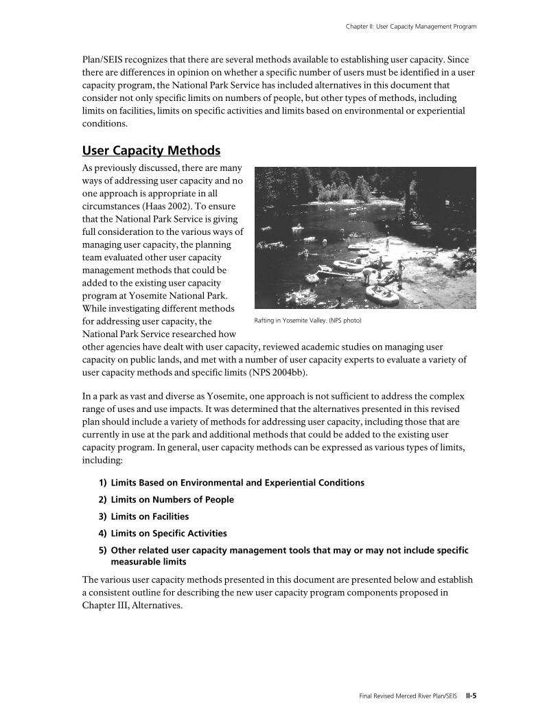
Rafting in Yosemite Valley. (NPS photo)
Chapter II: User Capacity Management Program
II-6 Final Revised Merced River Plan/SEIS
1) Existing Limits Based on Environmental and Experiential Conditions With limits based on environmental and experiential conditions, the overall condition of natural and cultural resources and the quality of visitor experience are monitored and then controlled through management actions. Using this method, the National Park Service sets quantifiable standards for resource and visitor experience conditions; these standards are designed to protect the river’s Outstandingly Remarkable Values. If the standards are not being met or conditions are degrading, park managers take action as needed or appropriate to restore the desired conditions. For example, if an area contains wetlands and riverbanks, the conditions of these resources are monitored to ensure that use levels in the area are not adversely affecting these resources. If resource conditions are deteriorating, park managers take steps to change use such as reducing use levels, redirecting use away from sensitive areas, or changing the type or timing of use. So, if a riverbank is eroding because a high number of rafters use the area to launch rafts, park managers might limit the number of people who can use the area to launch rafts or close the area to raft launching and direct these people to an area that is better suited to this use.
Visitor experience conditions include factors such as perceived crowding and traffic congestion. Visitor surveys indicate that crowding and traffic are the two factors that most adversely affect visitors’ recreation experience (Manning et al. 1999a, ORCA 2000). By setting traffic congestion as a standard for visitor experience, the congestion can serve as a measure to indicate whether or not conditions are acceptable. When traffic conditions deteriorate, park managers would need to reduce the number of vehicles allowed in an area to make sure that traffic congestion standards are not exceeded — that is, that traffic is not so congested that it exceeds the acceptable limit. This method of managing user capacity is the basis for the VERP program described later in this chapter.
2) Limits on Numbers of People Another user capacity method is to establish limits on the number of users. This type of limit can be implemented in several ways. For example, it is possible to limit the number of people in the river corridor, in each river segment, or in each management zone. Similarly, these limits can be expressed as the number of people in 1 year, the number of people over 24 hours, or the number of people at any one time. Some of the action alternatives in Chapter III explore these various approaches to managing numbers of people.
3) Limits on Facilities Facility limits is one method of managing use and includes restrictions on the amount of overnight lodging and camping, the number of private vehicle parking spaces, the number of bus parking spaces, etc. When facility limits are implemented, the management focus is not on the exact number of people in an area. Hypothetically, in an area with a specific amount of parking capacity, the number of people in the area could be very different on a day with an average of two people per car versus an average of four people per car. In practice, Yosemite has derived an average number of people per car (as well as the average number of people per lodging room and campsite), and these averages are based on park visitation data collected over the years. Although the exact number of people is not being directly controlled through facility limits, the range in the number of people is limited because most people access the park by car and cannot access a developed area if they cannot find a place to park. Thus, use is limited by managing the capacity of various facilities.
Chapter II: User Capacity Management Program
Final Revised Merced River Plan/SEIS II-7
The effectiveness of this type of user capacity limit is demonstrated in Yosemite Valley each day. Visitors tend to congregate in the east Valley where parking and other visitor facilities are concentrated. On the other hand, visitor use levels in the west Valley, where parking and shuttle access is limited, remains well below east Valley levels.
4) Limits on Specific Activities Limits on specific activities regulate what activities can be done in a certain area or during a certain time period. For example, in Yosemite there are currently regulations on where people can raft in the Merced River, and these regulations restrict rafting during certain time periods based on water levels. Other restrictions apply to where fishing is allowed, the type of fishing lures and hooks that can be used, and limits on the number of fish that can be caught. In addition, there are other regulations that limit various activities to certain areas in order to protect park resources. For example bicycle use is only allowed on paved roads or designated multi-use paved trails in Yosemite Valley.
5) Other Related User Capacity Methods In addition to user capacity methods that can be expressed as specific limits, as described previously, other types of methods can affect user capacity. A number of federal laws require the National Park Service to protect resources from use-related impacts, even if they do not require the specific identification of a user capacity. The National Park Service has several ongoing natural and cultural resource protection and enhancement programs that are implemented throughout Yosemite to comply with these federal laws and National Park Service directives. In addition, methods such as management zoning provide guidance for managing user capacity by prescribing the desired types and levels of use and development for various areas within the park and within the river corridor.
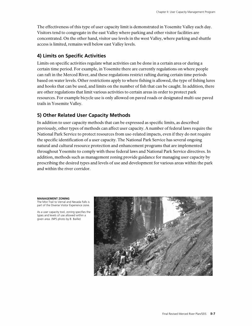
MANAGEMENT ZONING The Mist Trail to Vernal and Nevada Falls is part of the Diverse Visitor Experience zone. As a user capacity tool, zoning specifies the types and levels of use allowed within a given area. (NPS photo by B. Baillie)
Chapter II: User Capacity Management Program
II-8 Final Revised Merced River Plan/SEIS
Yosemite National Park’s Existing User Capacity Management Program Managing the impacts of visitor use is nothing new in Yosemite. For years, systems have been in place to establish limits on various uses. Although the Merced River Plan adopted in 2000 identified the VERP process as one of the National Park Service’s preferred methods for addressing user capacity, a number of other methods have been and are currently being used to manage user capacity in Yosemite National Park. Some of these methods include overnight visitor limits in wilderness, group size limits on trails, facility and utility capacity limits, seasonal and area restrictions on uses such as rafting, and other limits. While all of these measures address user capacity and the potential for user impacts on park resources, the Revised Merced River Plan/SEIS looks at alternatives that would add new and more comprehensive measures to the ongoing user capacity management program at Yosemite National Park.
Yosemite National Park published its User Capacity Management Program for the Merced Wild and Scenic River Corridor in 2004 (NPS 2004a). It summarizes the various components that exist in the park today to address user capacity and resource impacts. The primary user capacity components are summarized and described in table III-1 in the discussion of the No Action Alternative. A summary of Yosemite’s Existing User Capacity Management Program is presented below. Except where noted in Chapter III, Alternatives, this Yosemite User Capacity Management Program is common to all alternatives.
1) Existing Limits Based on Environmental and Experiential Conditions
Wilderness Impacts Monitoring System The Wilderness Impacts Monitoring System (WIMS) began in the 1970s. Under WIMS, the National Park Service conducts wilderness-wide inventory and monitoring studies focused on campsite and trail impacts. Data gathered from these studies are used to determine when, where, and why significant change occurs, and to provide a system for tracking those changes. It provides wilderness managers a system to help understand the relationship of natural conditions, visitor experience, and wilderness resource management. WIMS is also used to track the effectiveness of the Wilderness Trailhead Quota System in preventing unacceptable human-caused changes. Information from WIMS has been used over the years to adjust the trailhead quotas as needed to protect wilderness resources.
Visitor Experience and Resource Protection (VERP) Framework The VERP framework is a tool developed by the National Park Service to address user capacities and ensure the protection of natural and cultural resources and the visitor experience (Hof and Lime 1997). From Arches to Acadia National Parks, VERP programs have been helping park managers address the impacts of visitor use since the 1990s (NPS 1997x, NPS 1995e). In Yosemite, the VERP program being implemented will monitor of the overall health of park resources and the Outstandingly Remarkable Values. It will implement management actions to protect and enhance the Outstandingly Remarkable Values. The VERP process will serve as a regular report card, informing the public on a quarterly basis of the status of Outstandingly Remarkable Values, as well as the management actions being taken to protect and enhance them.
In the VERP framework, user capacity is defined as “the types and levels of visitor use that can be accommodated while sustaining the desired resource and social conditions that sustain the
Chapter II: User Capacity Management Program
Final Revised Merced River Plan/SEIS II-9
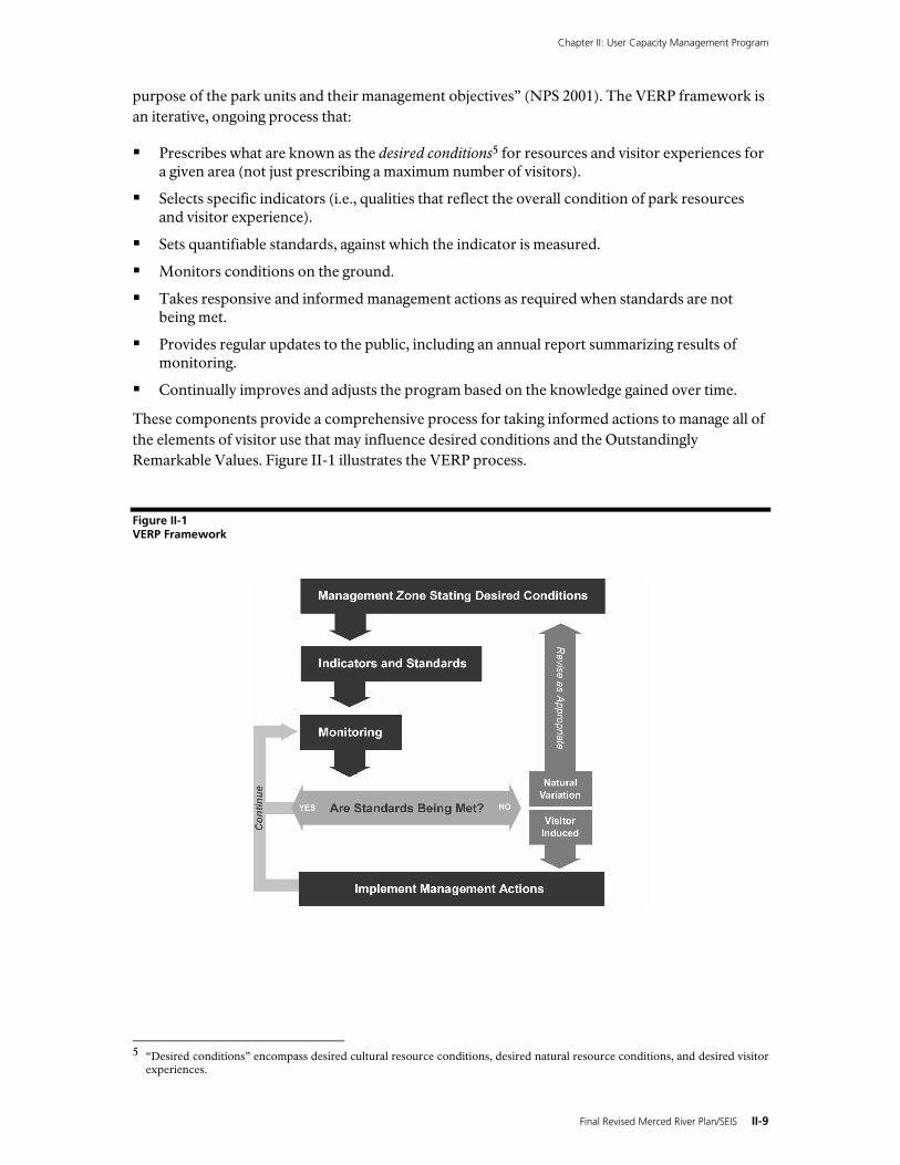
purpose of the park units and their management objectives” (NPS 2001). The VERP framework is an iterative, ongoing process that:
Prescribes what are known as the desired conditions5 for resources and visitor experiences for a given area (not just prescribing a maximum number of visitors).
Selects specific indicators (i.e., qualities that reflect the overall condition of park resources and visitor experience).
Sets quantifiable standards, against which the indicator is measured.
Monitors conditions on the ground.
Takes responsive and informed management actions as required when standards are not being met.
Provides regular updates to the public, including an annual report summarizing results of monitoring.
Continually improves and adjusts the program based on the knowledge gained over time.
These components provide a comprehensive process for taking informed actions to manage all of the elements of visitor use that may influence desired conditions and the Outstandingly Remarkable Values. Figure II-1 illustrates the VERP process.
Figure II-1 VERP Framework
5 “Desired conditions” encompass desired cultural resource conditions, desired natural resource conditions, and desired visitor
experiences.
Chapter II: User Capacity Management Program
II-10 Final Revised Merced River Plan/SEIS
VERP is a decision-making framework , enhancing and informing the park manager’s role in decision making. In fact, managers must make crucial decisions to determine desired conditions, choose appropriate management actions, and assess occasional overlap between protecting park resources and providing for visitor experience opportunities. The VERP framework is used as a form of adaptive management.6 Where uncertainty exists about impacts associated with visitor use, knowledge and understanding of visitor use issues improves and evolves over time, and management actions are adapted accordingly (Haas 2002). Continual hypothesis testing, data collection, and data analysis will result in the refinement of indicators and standards to better inform management decisions.
The VERP framework is based on the understanding that there are many aspects of visitor use that must be managed to protect desired conditions, including the number of people in an area, their behavior, when use occurs (timing), and how much use occurs within a specific area (distribution). All of these elements can affect desired resource and visitor experience conditions (Leung and Marion 2000). The VERP framework includes indicators and standards that set limits on the amount of change allowed to desired resource and visitor experience conditions that are affected by the various elements of visitor use. In summary, the VERP framework establishes quantitative measures of visitor capacity by setting specific measurable limits (standards) that allow for existing conditions to be compared to desired conditions. This process ultimately results in better information from which park managers can address the various aspects of visitor use.
VERP Framework Elements. Nine steps are integral to the development of the VERP framework. While the scope of the elements, the order in which they are undertaken, and the specific methods used to complete the elements may vary in different situations, all of the elements are necessary to implement a VERP program. Although the elements are numbered and may appear in a linear process, it is important to remember that the VERP framework is iterative, with feedback and “feed-forward” occurring throughout the elements. The nine VERP elements are as follows:
Element 1 Assemble an interdisciplinary project team
Element 2 Develop a public involvement strategy
Element 3 Develop statements of park purpose, significance, and primary interpretive themes; identifying planning constraints
Element 4 Analyze park resources and existing conditions
Element 5 Describe a potential range of visitor experiences and resource conditions (potential descriptive zones)
Element 6 Allocate the potential zones to specific locations in the park (prescriptive management zoning)
Element 7 Select indicators and specify standards for each zone; develop a monitoring plan
Element 8 Monitor resource and social indicators (analyze and evaluate indicator performance, continue monitoring with finalized indicators)
Element 9 Take management action
6 Adaptive management is a process that allows the development of a plan when some degree of biological and socioeconomic
uncertainty exists. It requires a continual learning process, a reiterative evaluation of goals and approaches, and redirection based on an increasing information base and changing public expectations (Baskerville 1985).
Chapter II: User Capacity Management Program
Final Revised Merced River Plan/SEIS II-11
What VERP Is Not. It is worth noting what VERP will not do:
VERP does not specify the total number of visitors that the river corridor, as a whole, can accommodate at one time. Such an aggregate figure would mask problems at “hot spots” and would not provide managers with useful guidance for addressing use-related problems.
As a framework for addressing user capacity, VERP is not driven by the capacity of existing infrastructure. Expanding or constructing facilities does not necessarily mitigate visitor use impacts to visitor experience or resources.
VERP, as applied in the Merced Wild and Scenic River corridor, may not directly transfer to other areas of Yosemite National Park. It may be implemented elsewhere in the park at some future date; desired conditions, indicators, and standards are being developed with this possible expansion in mind. However, due to an emphasis on protecting Outstandingly Remarkable Values and other factors, it is possible that future implementation of VERP outside of the Merced Wild and Scenic River corridor will not dovetail perfectly.
VERP does not address impacts that do not result directly from visitor use. Impacts from park operations and management activities (e.g., fire management), natural variability (e.g., high water), development (e.g., construction, demolition), and other causes not directly associated with visitor activities are managed through other methods.
VERP is not static. Visitor use patterns, desired visitor experiences, and resource conditions change with time. VERP is an iterative process of monitoring, evaluation, and adjustment.
Although the VERP framework was identified as the National Park Service’s primary user capacity management tool in the 2000 Merced River Plan, the remaining steps in the process had not been completed at the time of the Ninth Circuit Court of Appeals’ October 2003 decision. This Revised Merced River Plan/SEIS proposes a fully developed VERP program for Yosemite National Park, including the development of specific indicators and standards. A complete description of Yosemite’s VERP program is presented later in this chapter; standards and indicators are summarized in table II-5.
2) Existing Limits on Numbers of People
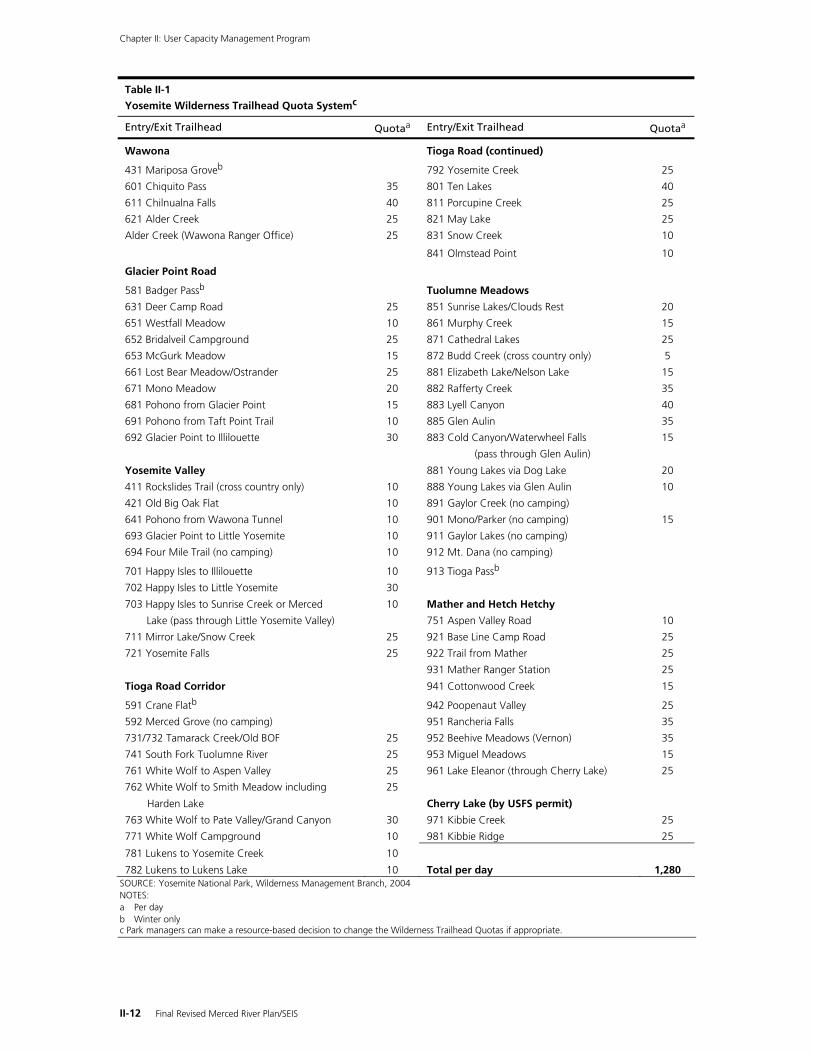
Wilderness Trailhead Quota System The Wilderness Management Program regulates wilderness use in Yosemite National Park, primarily through the Wilderness Trailhead Quota System. The daily quota for each wilderness trailhead is listed in table II-1. As shown, this system allows for a maximum of 1,280 overnight visitors to enter the wilderness each day.
The Wilderness Trailhead Quota System was established in the 1970s to protect wilderness areas within Yosemite National Park. This system assigns a daily quota for each wilderness trailhead in the park. The trailhead quota system protects both the visitor experience and the park’s natural and cultural resources by limiting and dispersing visitor use, which results in a quality visit while not causing unacceptable impacts to wilderness resources. It also enables agency personnel to contact all overnight visitors to educate them about wilderness regulations and each user’s responsibilities for protecting Yosemite’s wilderness.
Chapter II: User Capacity Management Program
II-12 Final Revised Merced River Plan/SEIS
Table II-1
Yosemite Wilderness Trailhead Quota Systemc
Entry/Exit Trailhead Quotaa Entry/Exit Trailhead Quotaa
Wawona Tioga Road (continued)
431 Mariposa Groveb 792 Yosemite Creek 25
601 Chiquito Pass 35 801 Ten Lakes 40
611 Chilnualna Falls 40 811 Porcupine Creek 25
621 Alder Creek 25 821 May Lake 25
Alder Creek (Wawona Ranger Office) 25 831 Snow Creek 10
841 Olmstead Point 10
Glacier Point Road
581 Badger Passb Tuolumne Meadows
631 Deer Camp Road 25 851 Sunrise Lakes/Clouds Rest 20
651 Westfall Meadow 10 861 Murphy Creek 15
652 Bridalveil Campground 25 871 Cathedral Lakes 25
653 McGurk Meadow 15 872 Budd Creek (cross country only) 5
661 Lost Bear Meadow/Ostrander 25 881 Elizabeth Lake/Nelson Lake 15
671 Mono Meadow 20 882 Rafferty Creek 35
681 Pohono from Glacier Point 15 883 Lyell Canyon 40
691 Pohono from Taft Point Trail 10 885 Glen Aulin 35
692 Glacier Point to Illilouette 30 883 Cold Canyon/Waterwheel Falls 15
(pass through Glen Aulin)
Yosemite Valley 881 Young Lakes via Dog Lake 20
411 Rockslides Trail (cross country only) 10 888 Young Lakes via Glen Aulin 10
421 Old Big Oak Flat 10 891 Gaylor Creek (no camping)
641 Pohono from Wawona Tunnel 10 901 Mono/Parker (no camping) 15
693 Glacier Point to Little Yosemite 10 911 Gaylor Lakes (no camping)
694 Four Mile Trail (no camping) 10 912 Mt. Dana (no camping)
701 Happy Isles to Illilouette 10 913 Tioga Passb
702 Happy Isles to Little Yosemite 30
703 Happy Isles to Sunrise Creek or Merced 10 Mather and Hetch Hetchy
Lake (pass through Little Yosemite Valley) 751 Aspen Valley Road 10
711 Mirror Lake/Snow Creek 25 921 Base Line Camp Road 25
721 Yosemite Falls 25 922 Trail from Mather 25
931 Mather Ranger Station 25
Tioga Road Corridor 941 Cottonwood Creek 15
591 Crane Flatb 942 Poopenaut Valley 25
592 Merced Grove (no camping) 951 Rancheria Falls 35
731/732 Tamarack Creek/Old BOF 25 952 Beehive Meadows (Vernon) 35
741 South Fork Tuolumne River 25 953 Miguel Meadows 15
761 White Wolf to Aspen Valley 25 961 Lake Eleanor (through Cherry Lake) 25
762 White Wolf to Smith Meadow including 25
Harden Lake Cherry Lake (by USFS permit)
763 White Wolf to Pate Valley/Grand Canyon 30 971 Kibbie Creek 25
771 White Wolf Campground 10 981 Kibbie Ridge 25
781 Lukens to Yosemite Creek 10
782 Lukens to Lukens Lake 10 Total per day 1,280 SOURCE: Yosemite National Park, Wilderness Management Branch, 2004 NOTES: a Per day b Winter only c Park managers can make a resource-based decision to change the Wilderness Trailhead Quotas if appropriate.
Chapter II: User Capacity Management Program
Final Revised Merced River Plan/SEIS II-13
The Wilderness Trailhead Quota System was adopted as part of the Merced River Plan. Together with the Wilderness Impact Monitoring System (WIMS), it allows park managers to regulate the type and amount of use in the wilderness segments of the river. Over time, this system has proven to be an effective way to achieve the desired visitor experience conditions while protecting Outstandingly Remarkable Values in these areas. The Wilderness Trailhead Quota System regulates use in 51 miles of the 81-mile Merced River corridor.
Superintendent’s Compendium The Superintendent’s Compendium7 (NPS 1999b) establishes specific regulations and policies for Yosemite National Park, including specific limits on use based on numbers. The Superintendent has the authority to manage visitor use to protect the park’s natural and cultural resources, and the Compendium documents the reasoning behind the use limits established under this authority (e.g., public use limits, rafting and fishing restrictions) Although these use limits and restrictions apply to various areas of the park, including some outside the Merced River corridor, those that specifically address uses within the Merced River corridor are described below:
Trailhead quota system limits total overnight entries into wilderness to 1,280 per day8.
Overnight visitors in wilderness areas may travel in groups of up to 15 if using established trails. On cross-country routes (off trail), overnight visitors may travel in groups of up to 8.
Day visitors in wilderness areas may travel in groups of up to a maximum of 35 people on established trails. Day visitors may travel off trail in groups of up to 8.
Stock use is limited to 25 head on existing trails. Stock are not allowed off trail except to feed and water.
The maximum number of bicyclists allowed in any one group is 30. Bicyclists are limited to paved roads and paved trails.
Park management may implement temporary access restrictions in Yosemite Valley when westbound traffic is backed up from Lower Yosemite Fall to the Curry Village four-way intersection or all day-visitor parking spaces have been filled.
Park management may implement temporary access restrictions in Wawona when all day use parking spaces have been filled.
General Management Plan Visitor Capacity Goals The Yosemite National Park General Management Plan was adopted in 1980. In that era, visitor carrying capacity for national park plans was based on the capacity of facilities and infrastructure. Changes to existing facilities and infrastructure were recommended to fulfill and support management objectives. In this method, facility capacity defined the visitor carrying capacity.
The General Management Plan visitor capacity “goals” were established based on facility capacities that were well below the actual level of facilities in 1980. That is, the existing facility capacities were greater than the capacities deemed optimum by the plan. Thus the General Management Plan called, not only for a reduction in facility capacity, but relocation of many existing facilities out of Yosemite Valley. These goals to remove and relocate facilities out of the Valley have guided all park planning efforts subsequent to the General Management Plan, including this plan. (For a comparison of facility capacities, see tables III-5 and III-6).
7 Under the authority of 16 USC Section 3 and Title 36 CFR Chapter 1, parts 1-7m the Superintendent’s Compendium establishes
specific regulations and policies for Yosemite National Park. 8 The trailhead quotas have been revised since the Superintendent’s Compendium was issued in 1999.
Chapter II: User Capacity Management Program
II-14 Final Revised Merced River Plan/SEIS
In the 1990s, national scientific and scholarly research, as well as National Park Service policy discussions, resulted in the adoption a new methodology for determining visitor carrying capacity. This methodology—the VERP framework—is described in Management Polices 2001 and in new Park Planning Program Standards signed in August 2004. While the land use management zones and general management direction of the 1980 General Management Plan still largely meet the 2004 Park Planning Program Standards, the 1980 approach to visitor carrying capacities do not. In order to meet the new policy standards, Yosemite National Park will amend that element of the General Management Plan by translating the former carrying capacity approach to the more responsive VERP process through each new planning effort undertaken within the river corridor. The visitor carrying capacity approach proposed in Alternative 2, the preferred alternative, for the Revised Merced River Plan/SEIS would therefore amend the subject corridor portion of the General Management Plan with regard to carrying capacity.
In the future, overall visitation could increase or decrease under Alternative 2 as compared with General Management Plan levels. The overall level of park visitation, including the types and levels of use, would be informed by the results of monitoring as a component of the VERP program, which is designed to ensure visitor levels do not degrade Outstandingly Remarkable Values.
3) Existing Limits on Facilities As noted in the General Management Plan and the User Capacity Management Program for the Merced Wild and Scenic River Corridor (NPS 1980, NPS 2004a), facility capacities are also used as specific measurable limits on park use. The General Management Plan called for the amounts and types of visitor use in the Merced River corridor to be managed through limiting the available facilities and then restricting access when these facilities were at capacity. Overnight capacity is largely controlled by the number of campsites and lodging units, along with the numbers of parking spaces provided for people using the Valley and Wawona to reach backcountry camping areas.9 Day visitor use is limited by the numbers of parking spaces and the capacity of the road system in the developed areas of the river corridor.
In addition to limits set by the capacity of the park’s facilities, use within the Merced River corridor is also limited by the capacity of the park’s utility systems – the ability of park infrastructure to collect and treat wastewater. The capacity of the Yosemite Valley and Wawona wastewater systems is limited by the permitted capacity of the wastewater treatment facilities in each area. Yosemite Valley and all of El Portal (along the main stem of the Merced River) are served by the El Portal Wastewater Treatment Plant. The Wawona area (along the South Fork of the Merced River) is served by the Wawona Wastewater Treatment Plant. The standards for wastewater collection and treatment are established through the U.S. Environmental Protection Agency. The state of California sets the capacity for each facility, mandating the overall capacity through an issued permit (on file at each facility). In accordance with this permit, the National Park Service cannot design or build any facilities that will exceed the permitted capacity established for wastewater treatment. At the El Portal Wastewater Treatment Plant, the permit establishes a treatment capacity of 1 million gallons per day. At the Wawona Wastewater Treatment Plant, the capacity has been set at 0.105 million gallons per day.
9 Backcountry overnight capacity is regulated by the Wilderness Trailhead Quota System and Wilderness Impact Management
System.
Chapter II: User Capacity Management Program
Final Revised Merced River Plan/SEIS II-15
4) Existing Limits on Specific Activities In addition to providing limits on the number of people as discussed previously, the Superintendent’s Compendium10 (NPS 1999b) establishes limits on specific activities. These limits and restrictions apply to various areas of the park, including the areas within the Merced River corridor:
The portion of the main stem of the Merced River between Stoneman Bridge and Sentinel Beach Picnic Area is open to all nonmotorized vessels designed specifically for carrying passengers within their structure on water between 10:00 a.m. Standard or Daylight Time and 6:00 p.m. Standard or Daylight Time.
The entire length of open water on the main stem of the Merced River is closed to all floatation devices whenever the river gauge at Sentinel Bridge reads 6.5 feet or higher and the combination of air and water temperature is less than 100 degrees Fahrenheit.
Fishing is prohibited at designated swimming beaches and from road bridges.
Off-trail stock use is prohibited except for the purpose of watering, rest stops, or overnight camping.
Bicycles are only permitted on roads and paved trails.
The following limits apply to fishing in the Merced River from the Happy Isles footbridge downstream to Foresta Road bridge in El Portal:
− Rainbow trout: catch and release only
− Brown trout: a limit of 5 per day or a total of 10 in possession
− Artificial lures or flies with barbless hooks only
In addition to placing limits on specific activities through the Superintendent’s Compendium, park managers could limit specific activities by other means. There are several activities regulated through the provisions of Special Use Permits. These include commercial bus use, filming, weddings, and other activities. Additionally, research permits are issued through the Division of Resources Management and Science for any academic or scientific study in the park.
5) Other Existing Related User Capacity Methods
Governing Mandates The basis for managing user capacity in Yosemite National Park comes from the governing mandates that direct management of the park. These governing mandates direct the National Park Service to protect the natural and cultural resources that exist in Yosemite, while allowing for the public enjoyment of these resources. Specific mandates, such as the Wild and Scenic Rivers Act, the 1982 Secretarial Guidelines for Wild and Scenic Rivers, and the National Park Service Management Policies 2001 (NPS 2000f), direct the National Park Service to specifically address user capacity to ensure that use levels do not result in unacceptable impacts to park natural and cultural resources, and to the visitor experience. Although these governing mandates do not themselves set specific measurable limits for visitor use, they establish the authority and responsibility upon which Yosemite’s user capacity program is established. Additional information on these and other governing mandates is provided in Appendix A.
10 Under the authority of 16 USC Section 3 and Title 36 CFR Chapter 1, parts 1-7m the Superintendent’s Compendium establishes
specific regulations and policies for Yosemite National Park.

Chapter II: User Capacity Management Program
II-16 Final Revised Merced River Plan/SEIS
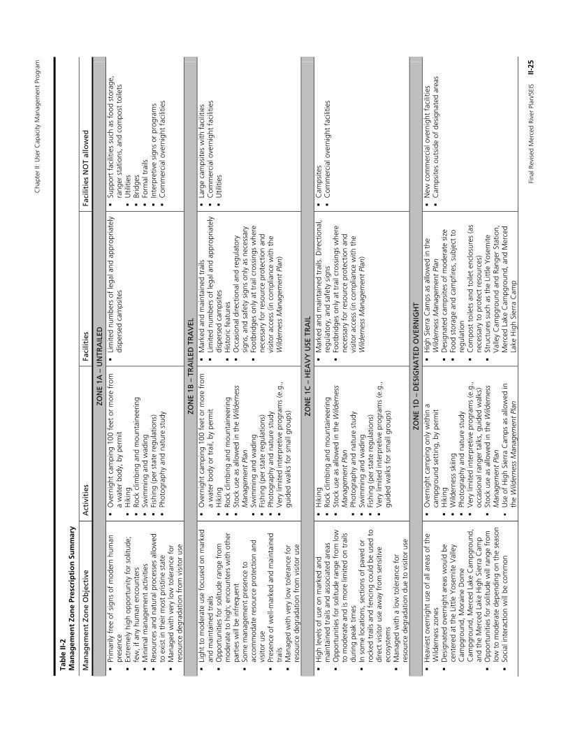
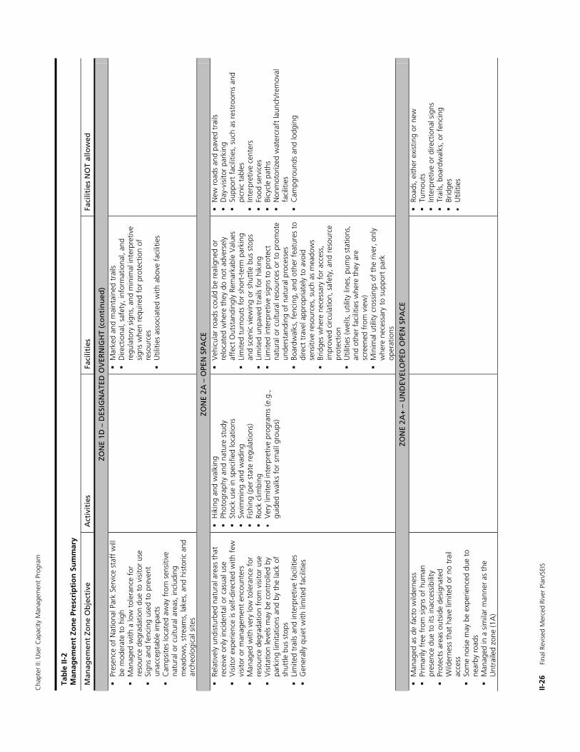
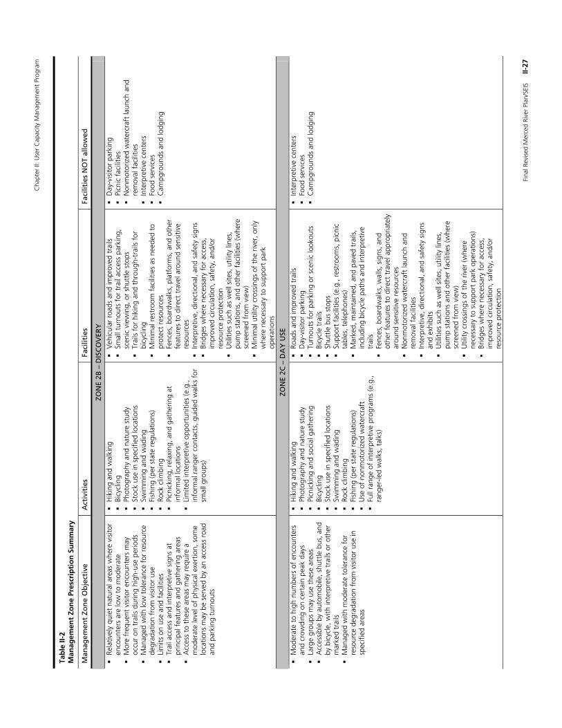
Management Zoning: Merced River Corridor Management zoning is a technique required by National Park Service policy to classify park areas and prescribe future desired resource conditions, as well as the desired type and level of visitor activities and facilities for each area. Management zoning for the Merced River corridor was adopted by the 2000 Merced River Plan (see pages 57-101 of the summary document completed in February 2001). The zones were developed to protect and enhance the Outstandingly Remarkable Values within each segment of the river. Specifically, the zones place an emphasis on integrating protection and enhancement of natural and cultural resources identified as Outstandingly Remarkable Values along with the protection and enhancement of the diverse recreation opportunities also identified as an Outstandingly Remarkable Value.
Since the management zones adopted in the Merced River Plan present the desired conditions for each zone, they are the basis for development of some of the user capacity alternatives discussed later in Chapter III. The management zones in the river corridor fall into three general categories: (1) Wilderness zones, (2) Diverse Visitor Experience zones, and (3) Developed zones. Within each of these three categories, individual subzones provide for certain levels and types of visitor experience opportunities, resource conditions, facilities, and uses.
The management zones are organized along a continuum of allowed impact intensity. For example, Wilderness zones generally prescribe the least amount and intensity of visitor use and facility development, leaving the landscape mostly natural and protecting Wilderness segment Outstandingly Remarkable Values. Diverse Visitor Experience zones allow for a low-to-high range of visitor use and low-to-moderate range of facility development. While emphasizing protection and enhancement of natural and cultural resource-related Outstandingly Remarkable Values, they provide the diverse recreational opportunities also identified as Outstandingly Remarkable Values. Developed zones also occur in Scenic and Recreational segments. These zones allow for the most intensive visitor use and/or more developed facilities. The developed areas encourage concentration of higher-impact activities in areas better able to withstand heavy use or at locations that are already developed, thus enabling better protection of Outstandingly Remarkable Values in other areas.
Each management zone prescribes the maximum level of activities and facilities allowed. In practice, lower levels of visitor use and facilities may be provided than are described in the zoning prescriptions. For example, areas zoned for overnight lodging may be used for less-developed activities such as walk-in camping or could include protected natural areas. The management zones delineated on the zoning maps allow park managers to direct activities, facilities, or development within the management zone. Within a given management zone, some areas may be used for higher-intensity facilities or activities, while other areas within the same management zone are left natural and open. Management zoning provides overall guidance for decision-making over the long term. Zoning does not attempt to predict or prescribe every conceivable use or facility decision. In addition, standards and indicators developed for Yosemite’s VERP program are based on the desired conditions established for each management zone, such as a range in the number of people for social indicators across zones where visitation levels and activities would be expected to vary.
Management zones for the river corridor are illustrated in figures II-2 through II-5 and a summary of the desired conditions for visitor use levels, facilities levels, and types of activities and facilities are described in table II-5. The river boundary and management zones for the El Portal Administrative Site are being re-evaluated in this Revised Merced River Plan/SEIS. Alternative boundaries and management zoning schemes being evaluated for El Portal are presented in Chapter III.
Chapter II: User Capacity Management Program
Final Revised Merced River Plan/SEIS II-17
Figure II-2 Management Zones for the Merced Wild and Scenic River

Chapter II: User Capacity Management Program
II-18 Final Revised Merced River Plan/SEIS
Chapter II: User Capacity Management Program
Final Revised Merced River Plan/SEIS II-19
Figure II-3 Yosemite Valley Management Zones for the Merced Wild and Scenic River

Chapter II: User Capacity Management Program
II-20 Final Revised Merced River Plan/SEIS
Chapter II: User Capacity Management Program
Final Revised Merced River Plan/SEIS II-21
Figure II-4 Gorge Management Zones for the Merced Wild and Scenic River

Chapter II: User Capacity Management Program
II-22 Final Revised Merced River Plan/SEIS

Chapter II: User Capacity Management Program
Final Revised Merced River Plan/SEIS II-23
Figure II-5 Wawona Management Zones for the Merced Wild and Scenic River

Chapter II: User Capacity Management Program
II-24 Final Revised Merced River Plan/SEIS
Cha
pter
II: U
ser
Cap
acity
Man
agem
ent
Prog
ram
Fina
l Rev
ised
Mer
ced
Rive
r Pl
an/S
EIS
II
-25
Tab
le II
-2
Man
agem
ent
Zon
e Pr
escr
ipti
on
Su
mm
ary
Man
agem
ent
Zon
e O
bje
ctiv
e A
ctiv
itie
s Fa
cilit
ies
Faci
litie
s N
OT
allo
wed
ZON
E 1A
– U
NTR
AIL
ED
Pr
imar
ily f
ree
of s
igns
of
mod
ern
hum
an
pres
ence
Extr
emel
y hi
gh o
ppor
tuni
ty f
or s
olitu
de;
few
, if
any
hum
an e
ncou
nter
s
M
inim
al m
anag
emen
t ac
tiviti
es
Re
sour
ces
and
natu
ral p
roce
sses
allo
wed
to
exi
st in
the
ir m
ost
pris
tine
stat
e
Man
aged
with
ver
y lo
w t
oler
ance
for
re
sour
ce d
egra
datio
n fr
om v
isito
r us
e
O
vern
ight
cam
ping
100
fee
t or
mor
e fr
om
a w
ater
bod
y, b
y pe
rmit
H
ikin
g
Rock
clim
bing
and
mou
ntai
neer
ing
Sw
imm
ing
and
wad
ing
Fi
shin
g (p
er s
tate
reg
ulat
ions
)
Phot
ogra
phy
and
natu
re s
tudy
Li
mite
d nu
mbe
rs o
f le
gal a
nd a
ppro
pria
tely
di
sper
sed
cam
psite
s
Su
ppor
t fa
cilit
ies
such
as
food
sto
rage
, ra
nger
sta
tions
, and
com
post
toi
lets
Util
ities
Brid
ges
Fo
rmal
tra
ils
In
terp
retiv
e si
gns
or p
rogr
ams
C
omm
erci
al o
vern
ight
fac
ilitie
s
ZON
E 1B
– T
RA
ILED
TR
AV
EL
Li
ght
to m
oder
ate
use
focu
sed
on m
arke
d an
d m
aint
aine
d tr
ails
Opp
ortu
nitie
s fo
r so
litud
e ra
nge
from
m
oder
ate
to h
igh;
enc
ount
ers
with
oth
er
part
ies
will
be
infr
eque
nt
So
me
man
agem
ent
pres
ence
to
acco
mm
odat
e re
sour
ce p
rote
ctio
n an
d vi
sito
r us
e
Pres
ence
of
wel
l-mar
ked
and
mai
ntai
ned
trai
ls
M
anag
ed w
ith v
ery
low
tol
eran
ce f
or
reso
urce
deg
rada
tion
from
vis
itor
use
O
vern
ight
cam
ping
100
fee
t or
mor
e fr
om
a w
ater
bod
y or
tra
il, b
y pe
rmit
Hik
ing
Ro
ck c
limbi
ng a
nd m
ount
aine
erin
g
Stoc
k us
e as
allo
wed
in t
he W
ilder
ness
M
anag
emen
t Pl
an
Sw
imm
ing
and
wad
ing
Fi
shin
g (p
er s
tate
reg
ulat
ions
)
Phot
ogra
phy
and
natu
re s
tudy
Ver
y lim
ited
inte
rpre
tive
prog
ram
s (e
.g.,
guid
ed w
alks
for
sm
all g
roup
s)
M
arke
d an
d m
aint
aine
d tr
ails
Lim
ited
num
bers
of
lega
l and
app
ropr
iate
ly
disp
erse
d ca
mps
ites
H
isto
ric f
eatu
res
O
ccas
iona
l dire
ctio
nal a
nd r
egul
ator
y si
gns,
and
saf
ety
sign
s on
ly a
s ne
cess
ary
Fo
otbr
idge
s on
ly a
t tr
ail c
ross
ings
whe
re
nece
ssar
y fo
r re
sour
ce p
rote
ctio
n an
d vi
sito
r ac
cess
(in
com
plia
nce
with
the
W
ilder
ness
Man
agem
ent
Plan
)
La
rge
cam
psite
s w
ith f
acili
ties
C
omm
erci
al o
vern
ight
fac
ilitie
s
Util
ities
ZON
E 1C
– H
EAV
Y U
SE T
RA
IL
H
igh
leve
ls o
f us
e on
mar
ked
and
mai
ntai
ned
trai
ls a
nd a
ssoc
iate
d ar
eas
O
ppor
tuni
ties
for
solit
ude
rang
e fr
om lo
w
to m
oder
ate
and
is m
ore
limite
d on
tra
ils
durin
g pe
ak t
imes
In s
ome
loca
tions
, sec
tions
of
pave
d or
ro
cked
tra
ils a
nd f
enci
ng c
ould
be
used
to
dire
ct v
isito
r us
e aw
ay f
rom
sen
sitiv
e ec
osys
tem
s
Man
aged
with
a lo
w t
oler
ance
for
re
sour
ce d
egra
datio
n du
e to
vis
itor
use
H
ikin
g
Rock
clim
bing
and
mou
ntai
neer
ing
Stoc
k us
e as
allo
wed
in t
he W
ilder
ness
M
anag
emen
t Pl
an
Ph
otog
raph
y an
d na
ture
stu
dy
Sw
imm
ing
and
wad
ing
Fi
shin
g (p
er s
tate
reg
ulat
ions
)
Ver
y lim
ited
inte
rpre
tive
prog
ram
s (e
.g.,
guid
ed w
alks
for
sm
all g
roup
s)
M
arke
d an
d m
aint
aine
d tr
ails
. Dire
ctio
nal,
regu
lato
ry, a
nd s
afet
y si
gns
Foot
brid
ges
only
at
trai
l cro
ssin
gs w
here
ne
cess
ary
for
reso
urce
pro
tect
ion
and
visi
tor
acce
ss (i
n co
mpl
ianc
e w
ith t
he
Wild
erne
ss M
anag
emen
t Pl
an)
C
amps
ites
C
omm
erci
al o
vern
ight
fac
ilitie
s
ZON
E 1D
– D
ESIG
NA
TED
OV
ERN
IGH
T
Hea
vies
t ov
erni
ght
use
of a
ll ar
eas
of t
he
Wild
erne
ss z
ones
Des
igna
ted
over
nigh
t ar
eas
wou
ld b
e ce
nter
ed a
t th
e Li
ttle
Yos
emite
Val
ley
Cam
pgro
und,
Mor
aine
Dom
e C
ampg
roun
d, M
erce
d La
ke C
ampg
roun
d,
and
the
Mer
ced
Lake
Hig
h Si
erra
Cam
p
Opp
ortu
nitie
s fo
r so
litud
e w
ill r
ange
fro
m
low
to
mod
erat
e de
pend
ing
on t
he s
easo
n
So
cial
inte
ract
ion
will
be
com
mon
O
vern
ight
cam
ping
onl
y w
ithin
a
cam
pgro
und
sett
ing,
by
perm
it
Hik
ing
W
ilder
ness
ski
ing
Ph
otog
raph
y an
d na
ture
stu
dy
V
ery
limite
d in
terp
retiv
e pr
ogra
ms
(e.g
., oc
casi
onal
ran
ger
talk
s, g
uide
d w
alks
)
Stoc
k us
e as
allo
wed
in t
he W
ilder
ness
M
anag
emen
t Pl
an
U
se o
f H
igh
Sier
ra C
amps
as
allo
wed
in
the
Wild
erne
ss M
anag
emen
t Pl
an
H
igh
Sier
ra C
amps
as
allo
wed
in t
he
Wild
erne
ss M
anag
emen
t Pl
an
D
esig
nate
d ca
mps
ites
of m
oder
ate
size
Food
sto
rage
and
cam
pfire
s, s
ubje
ct t
o re
gula
tion
C
ompo
st t
oile
ts a
nd t
oile
t en
clos
ures
(as
nece
ssar
y to
pro
tect
res
ourc
es)
St
ruct
ures
suc
h as
the
Litt
le Y
osem
ite
Val
ley
Cam
pgro
und
and
Rang
er S
tatio
n,
Mer
ced
Lake
Cam
pgro
und,
and
Mer
ced
Lake
Hig
h Si
erra
Cam
p
N
ew c
omm
erci
al o
vern
ight
fac
ilitie
s
Cam
psite
s ou
tsid
e of
des
igna
ted
area
s
Cha
pter
II: U
ser
Cap
acity
Man
agem
ent
Prog
ram
II-26
F
inal
Rev
ised
Mer
ced
Rive
r Pl
an/S
EIS
Tab
le II
-2
Man
agem
ent
Zon
e Pr
escr
ipti
on
Su
mm
ary
Man
agem
ent
Zon
e O
bje
ctiv
e A
ctiv
itie
s Fa
cilit
ies
Faci
litie
s N
OT
allo
wed
ZON
E 1D
– D
ESIG
NA
TED
OV
ERN
IGH
T (c
on
tin
ued
)
Pres
ence
of
Nat
iona
l Par
k Se
rvic
e st
aff
will
be
mod
erat
e to
hig
h
Man
aged
with
a lo
w t
oler
ance
for
re
sour
ce d
egra
datio
n du
e to
vis
itor
use
Sign
s an
d fe
ncin
g us
ed t
o pr
even
t un
acce
ptab
le im
pact
s
Cam
psite
s lo
cate
d aw
ay f
rom
sen
sitiv
e na
tura
l or
cultu
ral a
reas
, inc
ludi
ng
mea
dow
s, s
trea
ms,
lake
s, a
nd h
isto
ric a
nd
arch
eolo
gica
l site
s
Mar
ked
and
mai
ntai
ned
trai
ls
D
irect
iona
l, sa
fety
, inf
orm
atio
nal,
and
regu
lato
ry s
igns
, and
min
imal
inte
rpre
tive
sign
s w
hen
requ
ired
for
prot
ectio
n of
re
sour
ces
U
tiliti
es a
ssoc
iate
d w
ith a
bove
fac
ilitie
s
ZON
E 2A
– O
PEN
SPA
CE
Re
lativ
ely
undi
stur
bed
natu
ral a
reas
tha
t re
ceiv
e on
ly in
cide
ntal
or
casu
al u
se
V
isito
r ex
perie
nce
is s
elf-
dire
cted
with
few
vi
sito
r or
man
agem
ent
enco
unte
rs
M
anag
ed w
ith v
ery
low
tol
eran
ce f
or
reso
urce
deg
rada
tion
from
vis
itor
use
V
isita
tion
leve
ls m
ay b
e co
ntro
lled
by
park
ing
limita
tions
and
by
the
lack
of
shut
tle b
us s
tops
Lim
ited
trai
ls a
nd in
terp
retiv
e fa
cilit
ies
Gen
eral
ly q
uiet
with
lim
ited
faci
litie
s
H
ikin
g an
d w
alki
ng
Ph
otog
raph
y an
d na
ture
stu
dy
St
ock
use
in s
peci
fied
loca
tions
Swim
min
g an
d w
adin
g
Fi
shin
g (p
er s
tate
reg
ulat
ions
)
Rock
clim
bing
Ver
y lim
ited
inte
rpre
tive
prog
ram
s (e
.g.,
guid
ed w
alks
for
sm
all g
roup
s)
V
ehic
ular
roa
ds c
ould
be
real
igne
d or
re
loca
ted
whe
re t
hey
do n
ot a
dver
sely
af
fect
Out
stan
ding
ly R
emar
kabl
e V
alue
s
Lim
ited
turn
outs
for
sho
rt-t
erm
par
king
an
d sc
enic
vie
win
g or
shu
ttle
bus
sto
ps
Li
mite
d un
pave
d tr
ails
for
hik
ing
Li
mite
d in
terp
retiv
e si
gns
to p
rote
ct
natu
ral o
r cu
ltura
l res
ourc
es o
r to
pro
mot
e un
ders
tand
ing
of n
atur
al p
roce
sses
Boar
dwal
ks, f
enci
ng, a
nd o
ther
fea
ture
s to
di
rect
tra
vel a
ppro
pria
tely
to
avoi
d se
nsiti
ve r
esou
rces
, suc
h as
mea
dow
s
Brid
ges
whe
re n
eces
sary
for
acc
ess,
im
prov
ed c
ircul
atio
n, s
afet
y, a
nd r
esou
rce
prot
ectio
n
Util
ities
(wel
ls, u
tility
line
s, p
ump
stat
ions
, an
d ot
her
faci
litie
s w
here
the
y ar
e sc
reen
ed f
rom
vie
w)
M
inim
al u
tility
cro
ssin
gs o
f th
e riv
er, o
nly
whe
re n
eces
sary
to
supp
ort
park
op
erat
ions
N
ew r
oads
and
pav
ed t
rails
Day
-vis
itor
park
ing
Su
ppor
t fa
cilit
ies,
suc
h as
res
troo
ms
and
picn
ic t
able
s
Inte
rpre
tive
cent
ers
Fo
od s
ervi
ces
Bicy
cle
path
s
Non
mot
oriz
ed w
ater
craf
t la
unch
/rem
oval
fa
cilit
ies
C
ampg
roun
ds a
nd lo
dgin
g
ZON
E 2A
+ –
UN
DEV
ELO
PED
OPE
N S
PAC
E
M
anag
ed a
s de
fac
to w
ilder
ness
Prim
arily
fre
e fr
om s
igns
of
hum
an
pres
ence
due
to
its in
acce
ssib
ility
Prot
ects
are
as o
utsi
de d
esig
nate
d W
ilder
ness
tha
t ha
ve li
mite
d or
no
trai
l ac
cess
Som
e no
ise
may
be
expe
rienc
ed d
ue t
o ne
arby
roa
ds
M
anag
ed in
a s
imila
r m
anne
r as
the
U
ntra
iled
zone
(1A
)
Ro
ads,
eith
er e
xist
ing
or n
ew
Tu
rnou
ts
In
terp
retiv
e or
dire
ctio
nal s
igns
Trai
ls, b
oard
wal
ks, o
r fe
ncin
g
Brid
ges
Util
ities
Cha
pter
II: U
ser
Cap
acity
Man
agem
ent
Prog
ram
Fina
l Rev
ised
Mer
ced
Rive
r Pl
an/S
EIS
II
-27
Tab
le II
-2
Man
agem
ent
Zon
e Pr
escr
ipti
on
Su
mm
ary
Man
agem
ent
Zon
e O
bje
ctiv
e A
ctiv
itie
s Fa
cilit
ies
Faci
litie
s N
OT
allo
wed
ZON
E 2B
– D
ISC
OV
ERY
Rela
tivel
y qu
iet
natu
ral a
reas
whe
re v
isito
r en
coun
ters
are
low
to
mod
erat
e
M
ore
freq
uent
vis
itor
enco
unte
rs m
ay
occu
r on
tra
ils d
urin
g hi
gh-u
se p
erio
ds
M
anag
ed w
ith lo
w t
oler
ance
for
res
ourc
e de
grad
atio
n fr
om v
isito
r us
e
Lim
its o
n us
e an
d fa
cilit
ies
Trai
l acc
ess
and
inte
rpre
tive
sign
s at
pr
inci
pal f
eatu
res
and
gath
erin
g ar
eas
A
cces
s to
the
se a
reas
may
req
uire
a
mod
erat
e le
vel o
f ph
ysic
al e
xert
ion,
som
e lo
catio
ns m
ay b
e se
rved
by
an a
cces
s ro
ad
and
park
ing
turn
outs
H
ikin
g an
d w
alki
ng
Bi
cycl
ing
Ph
otog
raph
y an
d na
ture
stu
dy
St
ock
use
in s
peci
fied
loca
tions
Swim
min
g an
d w
adin
g
Fi
shin
g (p
er s
tate
reg
ulat
ions
)
Rock
clim
bing
Picn
icki
ng, r
elax
ing,
and
gat
herin
g at
in
form
al lo
catio
ns
Li
mite
d in
terp
retiv
e op
port
uniti
es (e
.g.,
info
rmal
ran
ger
cont
acts
, gui
ded
wal
ks f
or
smal
l gro
ups)
V
ehic
ular
roa
ds a
nd im
prov
ed t
rails
Smal
l tur
nout
s fo
r tr
ail a
cces
s pa
rkin
g,
scen
ic v
iew
ing,
or
shut
tle s
tops
Trai
ls f
or h
ikin
g an
d th
roug
h-tr
ails
for
bi
cycl
ing
M
inim
al r
estr
oom
fac
ilitie
s as
nee
ded
to
prot
ect
reso
urce
s
Fenc
es, b
oard
wal
ks, p
latf
orm
s, a
nd o
ther
fe
atur
es t
o di
rect
tra
vel a
roun
d se
nsiti
ve
reso
urce
s
Inte
rpre
tive,
dire
ctio
nal,
and
safe
ty s
igns
Brid
ges
whe
re n
eces
sary
for
acc
ess,
im
prov
ed c
ircul
atio
n, s
afet
y, a
nd/o
r re
sour
ce p
rote
ctio
n
Util
ities
suc
h as
wel
l site
s, u
tility
line
s,
pum
p st
atio
ns, a
nd o
ther
fac
ilitie
s (w
here
sc
reen
ed f
rom
vie
w)
M
inim
al u
tility
cro
ssin
gs o
f th
e riv
er, o
nly
whe
re n
eces
sary
to
supp
ort
park
op
erat
ions
D
ay-v
isito
r pa
rkin
g
Picn
ic f
acili
ties
N
onm
otor
ized
wat
ercr
aft
laun
ch a
nd
rem
oval
fac
ilitie
s
Inte
rpre
tive
cent
ers
Fo
od s
ervi
ces
C
ampg
roun
ds a
nd lo
dgin
g
ZON
E 2C
– D
AY
USE
Mod
erat
e to
hig
h nu
mbe
rs o
f en
coun
ters
an
d cr
owdi
ng o
n ce
rtai
n pe
ak d
ays
La
rge
grou
ps m
ay u
se t
hese
are
as
A
cces
sibl
e by
aut
omob
ile, s
hutt
le b
us, a
nd
by b
icyc
le, w
ith in
terp
retiv
e tr
ails
or
othe
r m
arke
d tr
ails
Man
aged
with
mod
erat
e to
lera
nce
for
reso
urce
deg
rada
tion
from
vis
itor
use
in
spec
ified
are
as
H
ikin
g an
d w
alki
ng
Ph
otog
raph
y an
d na
ture
stu
dy
Pi
cnic
king
and
soc
ial g
athe
ring
Bi
cycl
ing
St
ock
use
in s
peci
fied
loca
tions
Swim
min
g an
d w
adin
g
Ro
ck c
limbi
ng
Fi
shin
g (p
er s
tate
reg
ulat
ions
)
Use
of
nonm
otor
ized
wat
ercr
aft
Fu
ll ra
nge
of in
terp
retiv
e pr
ogra
ms
(e.g
., ra
nger
-led
wal
ks, t
alks
)
Ro
ads
and
impr
oved
tra
ils
D
ay-v
isito
r pa
rkin
g
Turn
outs
for
par
king
or
scen
ic lo
okou
ts
Bi
cycl
e tr
ails
Shut
tle b
us s
tops
Supp
ort
faci
litie
s (e
.g.,
rest
room
s, p
icni
c ta
bles
, tel
epho
nes)
Mar
ked,
mai
ntai
ned,
and
pav
ed t
rails
, in
clud
ing
bicy
cle
path
s an
d in
terp
retiv
e tr
ails
Fenc
es, b
oard
wal
ks, w
alls
, sig
ns, a
nd
othe
r fe
atur
es t
o di
rect
tra
vel a
ppro
pria
tely
ar
ound
sen
sitiv
e re
sour
ces
N
onm
otor
ized
wat
ercr
aft
laun
ch a
nd
rem
oval
fac
ilitie
s
Inte
rpre
tive,
dire
ctio
nal,
and
safe
ty s
igns
an
d ex
hibi
ts
U
tiliti
es s
uch
as w
ell s
ites,
util
ity li
nes,
pu
mp
stat
ions
and
oth
er f
acili
ties
(whe
re
scre
ened
fro
m v
iew
)
Util
ity c
ross
ings
of
the
river
(whe
re
nece
ssar
y to
sup
port
par
k op
erat
ions
)
Brid
ges
whe
re n
eces
sary
for
acc
ess,
im
prov
ed c
ircul
atio
n, s
afet
y, a
nd/o
r re
sour
ce p
rote
ctio
n
In
terp
retiv
e ce
nter
s
Food
ser
vice
s
Cam
pgro
unds
and
lodg
ing
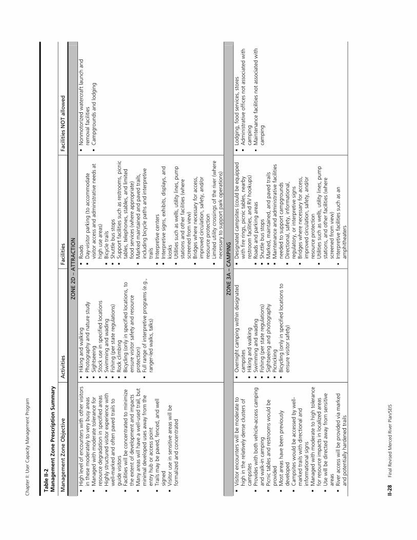
Cha
pter
II: U
ser
Cap
acity
Man
agem
ent
Prog
ram
II-28
F
inal
Rev
ised
Mer
ced
Rive
r Pl
an/S
EIS
Tab
le II
-2
Man
agem
ent
Zon
e Pr
escr
ipti
on
Su
mm
ary
Man
agem
ent
Zon
e O
bje
ctiv
e A
ctiv
itie
s Fa
cilit
ies
Faci
litie
s N
OT
allo
wed
ZON
E 2D
– A
TTR
AC
TIO
N
H
igh
leve
l of
enco
unte
rs w
ith o
ther
vis
itors
in
the
se m
oder
atel
y to
ver
y bu
sy a
reas
Man
aged
with
mod
erat
e to
lera
nce
for
reso
urce
deg
rada
tion
in s
peci
fied
area
s
Hig
hly
stru
ctur
ed v
isito
r ex
perie
nce
with
w
ell-m
arke
d an
d of
ten
pave
d tr
ails
to
guid
e vi
sito
rs
Fa
cilit
ies
will
be
conc
entr
ated
to
min
imiz
e th
e ex
tent
of
deve
lopm
ent
and
impa
cts
Man
y ar
eas
will
hav
e a
wel
l-use
d tr
ail,
but
min
imal
dev
elop
ed u
ses
away
fro
m t
he
entr
y hu
b or
acc
ess
poin
t
Tr
ails
may
be
pave
d, f
ence
d, a
nd w
ell
sign
ed
V
isito
r us
e in
sen
sitiv
e ar
eas
will
be
form
aliz
ed a
nd c
once
ntra
ted
H
ikin
g an
d w
alki
ng
Ph
otog
raph
y an
d na
ture
stu
dy
Si
ghts
eein
g
Stoc
k us
e in
spe
cifie
d lo
catio
ns
Sw
imm
ing
and
wad
ing
Fish
ing
(per
sta
te r
egul
atio
ns)
Ro
ck c
limbi
ng
Bi
cycl
ing
(onl
y in
spe
cifie
d lo
catio
ns, t
o en
sure
vis
itor
safe
ty a
nd r
esou
rce
prot
ectio
n)
Fu
ll ra
nge
of in
terp
retiv
e pr
ogra
ms
(e.g
., ra
nger
-led
wal
ks, t
alks
)
Ro
ads
Day
-vis
itor
park
ing
(to
acco
mm
odat
e vi
sito
r ac
cess
and
adm
inis
trat
ive
need
s at
hi
gh u
se a
reas
)
Bicy
cle
trai
ls
Sh
uttle
bus
sto
ps
Su
ppor
t fa
cilit
ies
such
as
rest
room
s, p
icni
c ta
bles
, tel
epho
nes,
sta
bles
, and
lim
ited
food
ser
vice
s (w
here
app
ropr
iate
)
Mar
ked
mai
ntai
ned
and
pave
d tr
ails
, in
clud
ing
bicy
cle
path
s an
d in
terp
retiv
e tr
ails
Inte
rpre
tive
cent
ers
In
terp
retiv
e si
gns,
exh
ibits
, dis
play
s, a
nd
kios
ks
U
tiliti
es s
uch
as w
ells
, util
ity li
nes,
pum
p st
atio
ns a
nd o
ther
fac
ilitie
s (w
here
sc
reen
ed f
rom
vie
w)
Br
idge
s w
here
nec
essa
ry f
or a
cces
s,
impr
oved
circ
ulat
ion,
saf
ety,
and
/or
reso
urce
pro
tect
ion
Lim
ited
utili
ty c
ross
ings
of
the
river
(whe
re
nece
ssar
y to
sup
port
par
k op
erat
ions
)
N
onm
otor
ized
wat
ercr
aft
laun
ch a
nd
rem
oval
fac
ilitie
s
Cam
pgro
unds
and
lodg
ing
ZON
E 3A
– C
AM
PIN
G
V
isito
r en
coun
ters
will
be
mod
erat
e to
hi
gh in
the
rel
ativ
ely
dens
e cl
uste
rs o
f ca
mps
ites
Prov
ides
with
bot
h ve
hicl
e-ac
cess
cam
ping
an
d w
alk-
in c
ampi
ng
Pi
cnic
tab
les
and
rest
room
s w
ould
be
prov
ided
Mos
t ar
eas
have
bee
n pr
evio
usly
de
velo
ped
C
amps
ites
wou
ld b
e ac
cess
ed b
y w
ell-
mar
ked
trai
ls w
ith d
irect
iona
l and
in
form
atio
nal s
igns
Man
aged
with
mod
erat
e to
hig
h to
lera
nce
for
reso
urce
impa
cts
in lo
caliz
ed a
reas
Use
will
be
dire
cted
aw
ay f
rom
sen
sitiv
e ar
eas
Rive
r ac
cess
will
be
prov
ided
via
mar
ked
and
pote
ntia
lly h
arde
ned
trai
ls
O
vern
ight
cam
ping
with
in d
esig
nate
d ca
mps
ites
H
ikin
g an
d w
alki
ng
Sw
imm
ing
and
wad
ing
Fi
shin
g (p
er s
tate
reg
ulat
ions
)
Sigh
tsee
ing
and
phot
ogra
phy
Pi
cnic
king
Bicy
clin
g (o
nly
in s
peci
fied
loca
tions
to
ensu
re v
isito
r sa
fety
)
D
esig
nate
d ca
mps
ites
(cou
ld b
e eq
uipp
ed
with
fire
rin
gs, p
icni
c ta
bles
, nea
rby
rest
room
fac
ilitie
s, a
nd R
V h
ooku
ps)
Ro
ads
and
park
ing
area
s
Shut
tle b
us s
tops
Mar
ked,
mai
ntai
ned,
and
pav
ed t
rails
Mai
nten
ance
and
adm
inis
trat
ive
faci
litie
s ne
eded
to
supp
ort
cam
pgro
unds
Dire
ctio
nal,
safe
ty, i
nfor
mat
iona
l, re
gula
tory
, or
inte
rpre
tive
sign
s
Brid
ges
whe
re n
eces
sary
for
acc
ess,
im
prov
ed c
ircul
atio
n, s
afet
y, a
nd/o
r re
sour
ce p
rote
ctio
n
Util
ities
suc
h as
wel
ls, u
tility
line
s, p
ump
stat
ions
, and
oth
er f
acili
ties
(whe
re
scre
ened
fro
m v
iew
)
Inte
rpre
tive
faci
litie
s su
ch a
s an
am
phith
eate
rs
Lo
dgin
g, f
ood
serv
ices
, sto
res
A
dmin
istr
ativ
e of
fices
not
ass
ocia
ted
with
ca
mpi
ng
M
aint
enan
ce f
acili
ties
not
asso
ciat
ed w
ith
cam
ping
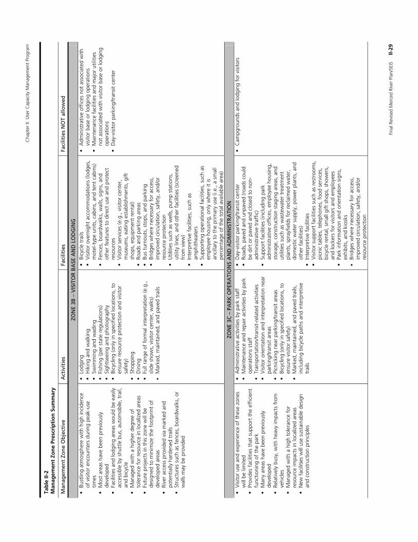
Cha
pter
II: U
ser
Cap
acity
Man
agem
ent
Prog
ram
Fina
l Rev
ised
Mer
ced
Rive
r Pl
an/S
EIS
II
-29
Tab
le II
-2
Man
agem
ent
Zon
e Pr
escr
ipti
on
Su
mm
ary
Man
agem
ent
Zon
e O
bje
ctiv
e A
ctiv
itie
s Fa
cilit
ies
Faci
litie
s N
OT
allo
wed
ZON
E 3B
– V
ISIT
OR
BA
SE A
ND
LO
DG
ING
Bust
ling
atm
osph
ere
with
hig
h in
cide
nce
of v
isito
r en
coun
ters
dur
ing
peak
-use
tim
es
M
ost
area
s ha
ve b
een
prev
ious
ly
deve
lope
d
Faci
litie
s an
d lo
dgin
g ar
eas
wou
ld b
e ea
sily
ac
cess
ible
by
shut
tle b
us, a
utom
obile
, tra
il,
and
bicy
cle
M
anag
ed w
ith a
hig
her
degr
ee o
f to
lera
nce
for
reso
urce
in lo
caliz
ed a
reas
Futu
re p
roje
cts
in t
his
zone
will
be
desi
gned
to
min
imiz
e th
e fo
otpr
int
of
deve
lope
d ar
eas
Ri
ver
acce
ss p
rovi
ded
via
mar
ked
and
pote
ntia
lly h
arde
ned
trai
ls
St
ruct
ures
suc
h as
fen
ces,
boa
rdw
alks
, or
wal
ls m
ay b
e pr
ovid
ed
Lo
dgin
g
Hik
ing
and
wal
king
Swim
min
g an
d w
adin
g
Fish
ing
(per
sta
te r
egul
atio
ns)
Si
ghts
eein
g an
d ph
otog
raph
y
Bicy
clin
g (o
nly
in s
peci
fied
loca
tions
, to
ensu
re r
esou
rce
prot
ectio
n an
d vi
sito
r sa
fety
)
Shop
ping
Din
ing
Fu
ll ra
nge
of f
orm
al in
terp
reta
tion
(e.g
., sl
ide
show
s, v
isito
r ce
nter
, wal
ks)
M
arke
d, m
aint
aine
d, a
nd p
aved
tra
ils
Bi
cycl
e tr
ails
Vis
itor
over
nigh
t ac
com
mod
atio
ns (l
odge
s,
mot
el-t
ype
units
, cab
ins,
and
ten
t ca
bins
)
Fenc
es, b
oard
wal
ks, w
alls
, sig
ns, a
nd
othe
r fe
atur
es t
o di
rect
use
and
pro
tect
re
sour
ces
Vis
itor
serv
ices
(e.g
., vi
sito
r ce
nter
, m
useu
ms,
eat
ing
esta
blis
hmen
ts, g
ift
shop
s, e
quip
men
t re
ntal
)
Road
s an
d pa
rkin
g ar
eas
Bus
turn
outs
, sto
ps, a
nd p
arki
ng
Br
idge
s w
here
nec
essa
ry f
or a
cces
s,
impr
oved
circ
ulat
ion,
saf
ety,
and
/or
reso
urce
pro
tect
ion
U
tiliti
es s
uch
as w
ells
, pum
p st
atio
ns,
utili
ty li
nes,
and
oth
er f
acili
ties
(scr
eene
d fr
om v
iew
)
Inte
rpre
tive
faci
litie
s, s
uch
as
amph
ithea
ters
Supp
ortin
g op
erat
iona
l fac
ilitie
s, s
uch
as
empl
oyee
hou
sing
, onl
y w
here
it is
an
cilla
ry t
o th
e pr
imar
y us
e (i.
e., a
sm
all
perc
enta
ge o
f th
e to
tal a
vaila
ble
area
)
A
dmin
istr
ativ
e of
fices
not
ass
ocia
ted
with
vi
sito
r ba
se o
r lo
dgin
g op
erat
ions
Mai
nten
ance
fac
ilitie
s an
d m
ajor
util
ities
no
t as
soci
ated
with
vis
itor
base
or
lodg
ing
oper
atio
ns
D
ay-v
isito
r pa
rkin
g/tr
ansi
t ce
nter
ZON
E 3C
– P
AR
K O
PER
ATI
ON
S A
ND
AD
MIN
ISTR
ATI
ON
Vis
itor
use
and
expe
rienc
e of
the
se z
ones
w
ill b
e lim
ited
Prov
ides
fac
ilitie
s th
at s
uppo
rt t
he e
ffic
ient
fu
nctio
ning
of
the
park
Man
y ar
eas
have
bee
n pr
evio
usly
de
velo
ped
Re
lativ
ely
busy
, with
hea
vy im
pact
s fr
om
vehi
cles
Man
aged
with
a h
igh
tole
ranc
e fo
r re
sour
ce im
pact
s in
loca
lized
are
as
N
ew f
acili
ties
will
use
sus
tain
able
des
ign
and
cons
truc
tion
prin
cipl
es
A
dmin
istr
ativ
e ac
tiviti
es b
y pa
rk s
taff
Mai
nten
ance
and
rep
air
activ
ities
by
park
op
erat
ions
sta
ff
Tr
ansp
orta
tion/
tran
sit-
rela
ted
activ
ities
Vis
itor
orie
ntat
ion
and
inte
rpre
tatio
n ne
ar
park
ing/
tran
sit
area
s
Picn
icki
ng n
ear
park
ing/
tran
sit
area
s
Bicy
clin
g (o
nly
in s
peci
fied
loca
tions
, to
ensu
re v
isito
r sa
fety
)
Mar
ked,
mai
ntai
ned,
and
pav
ed t
rails
, in
clud
ing
bicy
cle
path
s an
d in
terp
retiv
e tr
ails
D
ay-v
isito
r pa
rkin
g/tr
ansi
t ce
nter
Road
s, p
aved
and
unp
aved
(roa
ds c
ould
be
dirt
or
pave
d an
d cl
osed
to
non-
adm
inis
trat
ive
traf
fic)
Su
ppor
t fa
cilit
ies
(incl
udin
g pa
rk
adm
inis
trat
ive
offic
es, e
mpl
oyee
hou
sing
, st
orag
e, c
onst
ruct
ion
stag
ing
area
s, a
nd
utili
ties
such
as
was
tew
ater
tre
atm
ent
plan
ts, s
pray
field
s fo
r re
clai
med
wat
er,
dom
estic
wat
er s
uppl
y, p
ower
pla
nts,
and
ot
her
faci
litie
s)
In
terp
retiv
e fa
cilit
ies
V
isito
r su
ppor
t fa
cilit
ies
such
as
rest
room
s,
picn
ic t
able
s, t
elep
hone
s, f
ood
serv
ices
, bi
cycl
e re
ntal
, sm
all g
ift s
hops
, sho
wer
s,
and
lock
ers
for
visi
tors
and
em
ploy
ees
Pa
rk in
form
atio
n an
d or
ient
atio
n si
gns,
ex
hibi
ts, a
nd k
iosk
s
Brid
ges
whe
re n
eces
sary
for
acc
ess,
im
prov
ed c
ircul
atio
n, s
afet
y, a
nd/o
r re
sour
ce p
rote
ctio
n
C
ampg
roun
ds a
nd lo
dgin
g fo
r vi
sito
rs
Chapter II: User Capacity Management Program
II-30 Final Revised Merced River Plan/SEIS
Yosemite’s Visitor Experience and Resource Protection (VERP) Program In addition to the existing methods described previously in Yosemite’s User Capacity Management Program, the Revised Merced River Plan/SEIS implements a fully developed VERP program. The existing methods along with the inclusion of the VERP program are elements common to all action alternatives. The following section provides a complete description of how the VERP program will be applied to protect and enhance the Merced River’s Outstandingly Remarkable Values.
Desired Conditions/Management Zones As discussed previously, the VERP user capacity management program relies on the concept of desired conditions. Desired conditions are defined in management zone prescriptions, which identify how different areas in the river corridor would be managed. A set of desired resource conditions, desired visitor experience opportunities, and types and levels of appropriate uses are prescribed for each management zone. Indicators and standards (described in the next section) are developed to provide information on whether those desired resource conditions and visitor experience opportunities are being met. The 2000 Merced River Plan established the existing management zones in the river corridor to protect and enhance the Outstandingly Remarkable Values and the free-flowing condition of the Merced River. A summary of the management zones prescriptions was provided in the previous section. A detailed discussion of the relationship between specific management zones and the river’s Outstandingly Remarkable Values can be found in the Merced River Plan (NPS 2001a). The relationship between the revised zoning for the El Portal segment and Outstandingly Remarkable Values is provided in Chapter III, Alternatives in this document.
Specific and Measurable Indicators and Standards VERP allows park managers to translate desired conditions, which are qualitative in nature, into quantitative (measurable) indicators and standards. Indicators identify what is important to provide quality visitor experience and resource conditions. They represent the general health of conditions in the river corridor. Standards provide the thresholds against which indicators are measured. A standard is the line in the sand that triggers if or when management action should be taken. Together, indicators and standards compare existing conditions against desired conditions and enable park managers to determine whether or not desired conditions are being realized. Indicators, which are measurable variables, are determined first; standards quantifiably define the acceptable conditions (i.e., measured values) for each indicator. These acceptable conditions are set at a level that will protect and enhance the Merced River’s Outstandingly Remarkable Values. The VERP program developed in Yosemite includes both resource and social indicators to provide specific information regarding use-related effects on park resources and the river’s Outstandingly Remarkable Values.
The indicators and standards established through the VERP program do not assume a one-to-one relationship between an Outstandingly Remarkable Value and a given indicator and standard. Most indicators were selected to provide information regarding the health of a number of Outstandingly Remarkable Values. For example, by monitoring the length of informal or “social” trails in meadows within Discovery (2B) and Day Use (2C) management zones, resource
Chapter II: User Capacity Management Program
Final Revised Merced River Plan/SEIS II-31
managers are able to gain information regarding the condition of Outstandingly Remarkable Values as follows:
The length and condition of social trails is indicative of the contiguity and ecological health of meadows and wetland areas (part of the biological Outstandingly Remarkable Value).
The length of social trails in meadows is indicative of impacts to wildlife habitat, including special-status species whose habitat includes meadow areas (biological Outstandingly Remarkable Value).
Traditional gathering areas used by American Indian groups may exist in meadows, and meadows may be contributing elements in cultural landscapes. These cultural resources could be affected by the proliferation of social trails in meadows (cultural Outstandingly Remarkable Values).
The extent of social trails in meadows may affect visitor experience because meadows are enjoyable areas in which to engage in a variety of river-related recreational opportunities—including nature study and photography (recreation Outstandingly Remarkable Values).
Social trails may affect the scenic interface of river, rock, meadow, and forest; therefore, monitoring the length of social trails in meadows contributes to the protection and enhancement of the scenic Outstandingly Remarkable Values.
As shown by this example, monitoring of indicators would present data that pertain to several types of Outstandingly Remarkable Values. This benefits park managers by providing a host of data from which desired conditions can be assessed. In addition, the indicators were chosen with the intent of providing broad use-related condition information on the areas monitored, and should therefore reflect the condition of Outstandingly Remarkable Values that are sensitive to use-related impacts. Taken collectively, the indicators and standards presented in Yosemite’s VERP program would provide sound information on the overall condition of park resources, visitor experience opportunities, and the river’s Outstandingly Remarkable Values. In addition, the program itself would enhance the scientific Outstandingly Remarkable Values through the collection and evaluation of data relating to the Merced River and its environment.
The selection of specific indicators is an important step and requires consideration of a number of factors that relate to the effectiveness of the indicator. Park staff determined that indicators must be evaluated against a number of criteria, as listed below. In order to be considered, an indicator must be:
Connected to the Outstandingly Remarkable Values
Meaningful
Significant from an ecological or visitor experience perspective
Measurable/quantifiable
Representative of broader conditions
Repeatable
Affordable
Responsive to management input or management action
Related to use levels, behaviors, or patterns
Understandable to the public
Precise and accurate
Based on best available science
Chapter II: User Capacity Management Program
II-32 Final Revised Merced River Plan/SEIS
Feasible to implement
Able to provide an early warning for resource degradation
As park managers gain knowledge from VERP field-testing, indicators and standards may be further refined. This iterative learning and refining process is a strength of the VERP program, as the program can be adapted and improved as knowledge grows. If it is determined that a particular indicator is not providing meaningful information about resource or social conditions, monitoring methods for a particular indicator could be revised or the park may decide to discontinue monitoring of that particular indicator and develop a new indicator. For example, the Exposed Tree Roots in Campgrounds (as presented in table II-5) indicator was field tested in 2004. Park resource staff determined that the methods used for the indicators did not work as well as in the high country where soil type and vegetation is much different. As a result, the park decided to focus on other indicators that would provide more meaningful information about visitor use in campgrounds.
The National Park Service would inform the public of VERP program progress and proposed revisions to indicators and standards through regular communications, as described later in this section.
Monitoring For decades, the National Park Service has monitored the condition of many of Yosemite’s resources and has taken action to protect them. In the 1990s, Stoneman Meadow in Yosemite Valley contained a web of informal trails that were harming the meadow’s sensitive wetland vegetation and wildlife habitat. As a result, a boardwalk was installed to reduce the impacts of trampling. Today, use through the meadow is now directed to that boardwalk and plants and animals dependent on wetland habitats now thrive. While implementation of a VERP program in Yosemite is fairly new, its elements serve to formalize and improve on what the National Park Service has largely done for years. Monitoring is a key component to making informed visitor use management decisions under the VERP program. It is vital to have reliable data on resource conditions and visitor use so that park staff can ensure that existing conditions meet adopted standards. Indicator monitoring must be completed in consistent intervals and be based on sound science consistent with the values at stake and the decisions to be made. Intervals for monitoring the various indicators can range from monthly observations to surveys every few years and would vary depending on a number of factors, including the following:
The indicator being monitored
The status of the indicator relative to the established standard
The sampling strategy needed to understand natural variability and change over time
The zones and visitor use levels in question (high-use versus low-use areas)
The efficient use of available staff and funding
The length of time needed for a trend to become apparent
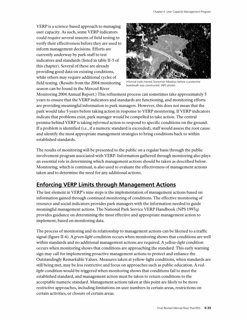
Chapter II: User Capacity Management Program
Final Revised Merced River Plan/SEIS II-33
VERP is a science-based approach to managing user capacity. As such, some VERP indicators could require several seasons of field testing to verify their effectiveness before they are used to inform management decisions. Efforts are currently underway by park staff to test indicators and standards (listed in table II-5 of this chapter). Several of these are already providing good data on existing conditions, while others may require additional cycles of field testing. (Results from the 2004 monitoring season can be found in the Merced River Monitoring 2004 Annual Report.) This refinement process can sometimes take approximately 5 years to ensure that the VERP indicators and standards are functioning, and monitoring efforts are providing meaningful information to park managers. However, this does not mean that the park would take 5 years before taking action in response to VERP monitoring. If VERP indicators indicate that problems exist, park manager would be compelled to take action. The central premise behind VERP is taking informed action to respond to specific conditions on the ground. If a problem is identified (i.e., if a numeric standard is exceeded), staff would assess the root cause and identify the most appropriate management strategies to bring conditions back to within established standards.
The results of monitoring will be presented to the public on a regular basis through the public involvement program associated with VERP. Information gathered through monitoring also plays an essential role in determining which management actions should be taken as described below. Monitoring, which is continual, is also used to evaluate the effectiveness of management actions taken and to determine the need for any additional actions.
Enforcing VERP Limits through Management Actions The last element in VERP’s nine steps is the implementation of management actions based on information gained through continued monitoring of conditions. The effective monitoring of resource and social indicators provides park managers with the information needed to guide meaningful management actions. The National Park Service VERP Handbook (NPS 1997q) provides guidance on determining the most effective and appropriate management action to implement, based on monitoring data.
The process of monitoring and its relationship to management actions can be likened to a traffic signal (figure II-6). A green-light condition occurs when monitoring shows that conditions are well within standards and no additional management actions are required. A yellow-light condition occurs when monitoring shows that conditions are approaching the standard. This early warning sign may call for implementing proactive management actions to protect and enhance the Outstandingly Remarkable Values. Measures taken at yellow-light conditions, when standards are still being met, may be less restrictive and focus on approaches such as public education. A red-light condition would be triggered when monitoring shows that conditions fail to meet the established standard, and management action must be taken to return conditions to the acceptable numeric standard. Management actions taken at this point are likely to be more restrictive approaches, including limitations on user numbers in certain areas, restrictions on certain activities, or closure of certain areas.
Informal trails marred Stoneman Meadow before a protective boardwalk was constructed. (NPS photo)
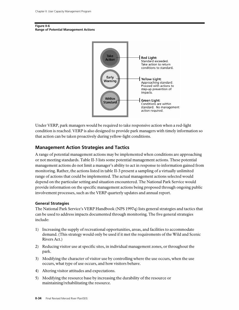
Chapter II: User Capacity Management Program
II-34 Final Revised Merced River Plan/SEIS
Figure II-6 Range of Potential Management Actions
Under VERP, park managers would be required to take responsive action when a red-light condition is reached. VERP is also designed to provide park managers with timely information so that action can be taken proactively during yellow-light conditions.
Management Action Strategies and Tactics A range of potential management actions may be implemented when conditions are approaching or not meeting standards. Table II-3 lists some potential management actions. These potential management actions do not limit a manager’s ability to act in response to information gained from monitoring. Rather, the actions listed in table II-3 present a sampling of a virtually unlimited range of actions that could be implemented. The actual management actions selected would depend on the particular setting and situation encountered. The National Park Service would provide information on the specific management actions being proposed through ongoing public involvement processes, such as the VERP quarterly updates and annual report.
General Strategies The National Park Service’s VERP Handbook (NPS 1997q) lists general strategies and tactics that can be used to address impacts documented through monitoring. The five general strategies include:
1) Increasing the supply of recreational opportunities, areas, and facilities to accommodate demand. (This strategy would only be used if it met the requirements of the Wild and Scenic Rivers Act.)
2) Reducing visitor use at specific sites, in individual management zones, or throughout the park.
3) Modifying the character of visitor use by controlling where the use occurs, when the use occurs, what type of use occurs, and how visitors behave.
4) Altering visitor attitudes and expectations.
5) Modifying the resource base by increasing the durability of the resource or maintaining/rehabilitating the resource.
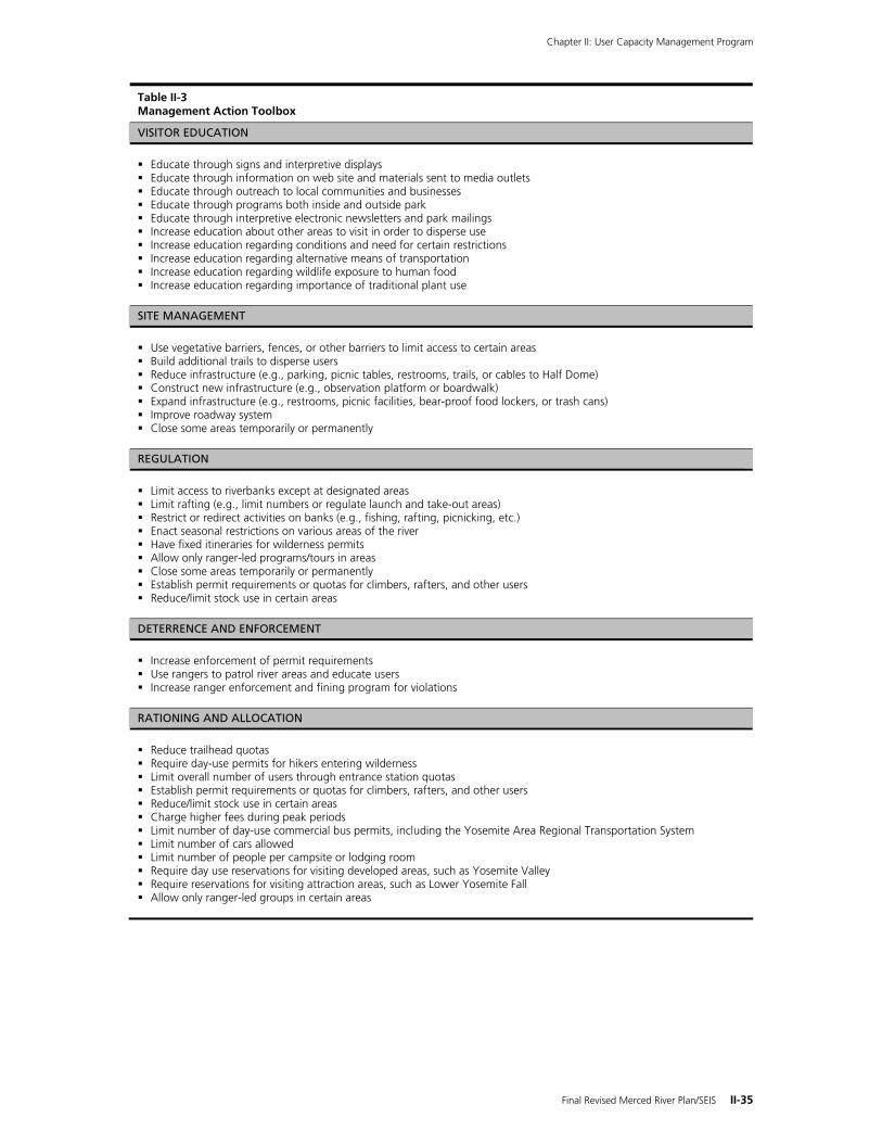
Chapter II: User Capacity Management Program
Final Revised Merced River Plan/SEIS II-35
Table II-3 Management Action Toolbox
VISITOR EDUCATION
Educate through signs and interpretive displays Educate through information on web site and materials sent to media outlets Educate through outreach to local communities and businesses Educate through programs both inside and outside park Educate through interpretive electronic newsletters and park mailings Increase education about other areas to visit in order to disperse use Increase education regarding conditions and need for certain restrictions Increase education regarding alternative means of transportation Increase education regarding wildlife exposure to human food Increase education regarding importance of traditional plant use
SITE MANAGEMENT
Use vegetative barriers, fences, or other barriers to limit access to certain areas Build additional trails to disperse users Reduce infrastructure (e.g., parking, picnic tables, restrooms, trails, or cables to Half Dome) Construct new infrastructure (e.g., observation platform or boardwalk) Expand infrastructure (e.g., restrooms, picnic facilities, bear-proof food lockers, or trash cans) Improve roadway system Close some areas temporarily or permanently
REGULATION
Limit access to riverbanks except at designated areas Limit rafting (e.g., limit numbers or regulate launch and take-out areas) Restrict or redirect activities on banks (e.g., fishing, rafting, picnicking, etc.) Enact seasonal restrictions on various areas of the river Have fixed itineraries for wilderness permits Allow only ranger-led programs/tours in areas Close some areas temporarily or permanently Establish permit requirements or quotas for climbers, rafters, and other users Reduce/limit stock use in certain areas
DETERRENCE AND ENFORCEMENT
Increase enforcement of permit requirements Use rangers to patrol river areas and educate users Increase ranger enforcement and fining program for violations
RATIONING AND ALLOCATION
Reduce trailhead quotas Require day-use permits for hikers entering wilderness Limit overall number of users through entrance station quotas Establish permit requirements or quotas for climbers, rafters, and other users Reduce/limit stock use in certain areas Charge higher fees during peak periods Limit number of day-use commercial bus permits, including the Yosemite Area Regional Transportation System Limit number of cars allowed Limit number of people per campsite or lodging room Require day use reservations for visiting developed areas, such as Yosemite Valley Require reservations for visiting attraction areas, such as Lower Yosemite Fall Allow only ranger-led groups in certain areas
Chapter II: User Capacity Management Program
II-36 Final Revised Merced River Plan/SEIS
Possible Tactics Tactics that park managers could implement in response to VERP monitoring also include five general categories:
1) Site management – including facility design, use of vegetative barriers, site hardening, and area or facility closures.
2) Rationing and allocation – including reservations, queuing, lotteries, eligibility requirements, and pricing adjustments.
3) Regulation – including the number of people/stock allowed in an area, the location or time allowed for uses, restrictions on the types of activities allowed, and restrictions on the types of equipment allowed.
4) Deterrence and enforcement – including restrictive signs, verbal or written warnings, tickets, fines, and increased enforcement patrols.
5) Visitor education – including fact sheets, interpretive programs, interpretive signs, and specific user group outreach efforts.
Questions to Consider In determining what management actions to take when a condition does not meet the standard, park managers would consider the following factors:
Would the action protect and enhance the Outstandingly Remarkable Values?
Would the action protect the free-flowing condition of the river?
Would the action adequately address the underlying cause or causes of the impact?
Would the action be effective in resolving the impact?
Would the action lead to creation of new problems?
Would the action be subtle or obtrusive in terms of visitor perceptions of being managed?
Would the action be direct or indirect in terms of how it influences visitor behavior?
How would the action affect visitor freedom of choice?
Would the action affect a large or small number of visitors?
Would the action affect an activity to which some visitors attach a great deal of importance?
Are visitors likely to resist the management action?
What are the costs to park management of implementing the action?
Before taking any management action, park managers would use VERP monitoring data to identify as clearly as possible the root causes of deteriorating or substandard conditions. Numerous factors may be responsible for conditions, such as the type and level of visitor use, the timing of use, or the design of facilities. When an impact is not due to visitor use (e.g., some sort of natural event or cause), the management actions to address the impact would not target visitor use, but instead would target the specific underlying cause that was identified. Management would use information from these various factors to determine the most appropriate management action to implement.
Chapter II: User Capacity Management Program
Final Revised Merced River Plan/SEIS II-37
The Role of Interpretation and Education as a Management Action The provision of an educational and enjoyable experience for park users is central to the National Park Service’s mission. Yosemite National Park’s Division of Interpretation and Education and park partners, such as the Yosemite Institute and Yosemite Association, reach out to park visitors in a number of ways to help them feel informed and connected to Yosemite. Visitors armed with information and knowledge about the meaning and significance of the park’s resources become better stewards of the land and take an interest in helping to protect resources. The range of educational programs emphasizes information about visitor impacts on resources and ways to reduce those impacts. Thus, education is an important element in the National Park Service efforts to manage use in the park and the Merced River corridor.
Educational messages can be an important management tool to prevent impacts to resources—or to reverse impacts that have already occurred (Gramann 2000). For example, when conflicts with bears obtaining human food reached record proportions, a Bear Awareness Campaign was launched. For several years, messages relating to the importance of storing food properly—in conjunction with other management actions, like installing nearly 2,000 bear-proof food storage lockers throughout the park—helped reduce the number of bear incidents in the park. When an area must be closed due to impacts in sensitive areas, management action is typically accompanied by efforts to educate visitors. Often, in areas containing protective fencing or boardwalks, educational signs inform users of the restoration efforts in progress and how visitors can help prevent future impacts—and even play a role in accelerating the restoration process. Education is a powerful and effective management action and has always played a vital role in helping the National Park Service fulfill its mission in Yosemite National Park. It continues to feature prominently as a management action in the various components of Yosemite’s User Capacity Management Program.
Review Process for Proposed Management Actions Management actions proposed for implementation would be required to comply with the requirements of NEPA, the National Historic Preservation Act, and other applicable laws. Depending on the action proposed, the appropriate level of environmental compliance would be completed. The National Park Service has a comprehensive NEPA screening process that is used to analyze all proposed park actions that have the potential to adversely affect the environment. For example, if monitoring in a given meadow determined that the standard for social trails was being exceeded, park managers might propose installation of a boardwalk or other protective measures, such as temporary closures. Since this could require limited construction activities in meadows, these proposals would likely be analyzed as part of a NEPA document and presented to the public for review and comment. In other cases where impacts were not as severe, educational efforts might be increased to redirect users away from a sensitive area, thereby helping to reduce impacts and keep conditions within a given standard. Implementation of educational measures would most likely not require any additional NEPA review. Table II-4 provides a list of the types of actions that typically are approved under a categorical exclusion11 versus those actions that typically require an environmental assessment or environmental impact statement.
11 A categorical exclusion is a type of federal actions that does not individually or cumulatively have a significant effect on the
human environment which therefore neither an Environmental Assessment (EA) nor an Environmental Impact Statement (EIS) is required.
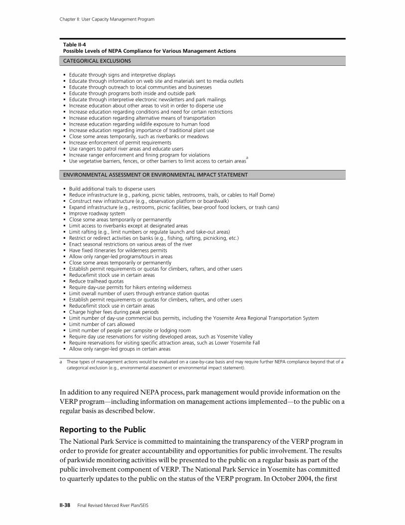
Chapter II: User Capacity Management Program
II-38 Final Revised Merced River Plan/SEIS
Table II-4 Possible Levels of NEPA Compliance for Various Management Actions
CATEGORICAL EXCLUSIONS Educate through signs and interpretive displays Educate through information on web site and materials sent to media outlets Educate through outreach to local communities and businesses Educate through programs both inside and outside park Educate through interpretive electronic newsletters and park mailings Increase education about other areas to visit in order to disperse use Increase education regarding conditions and need for certain restrictions Increase education regarding alternative means of transportation Increase education regarding wildlife exposure to human food Increase education regarding importance of traditional plant use Close some areas temporarily, such as riverbanks or meadows Increase enforcement of permit requirements Use rangers to patrol river areas and educate users Increase ranger enforcement and fining program for violations Use vegetative barriers, fences, or other barriers to limit access to certain areas
a
ENVIRONMENTAL ASSESSMENT OR ENVIRONMENTAL IMPACT STATEMENT Build additional trails to disperse users Reduce infrastructure (e.g., parking, picnic tables, restrooms, trails, or cables to Half Dome) Construct new infrastructure (e.g., observation platform or boardwalk) Expand infrastructure (e.g., restrooms, picnic facilities, bear-proof food lockers, or trash cans) Improve roadway system Close some areas temporarily or permanently Limit access to riverbanks except at designated areas Limit rafting (e.g., limit numbers or regulate launch and take-out areas) Restrict or redirect activities on banks (e.g., fishing, rafting, picnicking, etc.) Enact seasonal restrictions on various areas of the river Have fixed itineraries for wilderness permits Allow only ranger-led programs/tours in areas Close some areas temporarily or permanently Establish permit requirements or quotas for climbers, rafters, and other users Reduce/limit stock use in certain areas Reduce trailhead quotas Require day-use permits for hikers entering wilderness Limit overall number of users through entrance station quotas Establish permit requirements or quotas for climbers, rafters, and other users Reduce/limit stock use in certain areas Charge higher fees during peak periods Limit number of day-use commercial bus permits, including the Yosemite Area Regional Transportation System Limit number of cars allowed Limit number of people per campsite or lodging room Require day use reservations for visiting developed areas, such as Yosemite Valley Require reservations for visiting specific attraction areas, such as Lower Yosemite Fall Allow only ranger-led groups in certain areas
a These types of management actions would be evaluated on a case-by-case basis and may require further NEPA compliance beyond that of a
categorical exclusion (e.g., environmental assessment or environmental impact statement).
In addition to any required NEPA process, park management would provide information on the VERP program—including information on management actions implemented—to the public on a regular basis as described below.
Reporting to the Public The National Park Service is committed to maintaining the transparency of the VERP program in order to provide for greater accountability and opportunities for public involvement. The results of parkwide monitoring activities will be presented to the public on a regular basis as part of the public involvement component of VERP. The National Park Service in Yosemite has committed to quarterly updates to the public on the status of the VERP program. In October 2004, the first
Chapter II: User Capacity Management Program
Final Revised Merced River Plan/SEIS II-39
reporting session was held at a Yosemite Valley public meeting. A subsequent meeting was held in April 2005 after publication of the first annual VERP monitoring report. Future quarterly reports may be presented in public meetings or as written updates on the park’s web site or through its electronic newsletter currently emailed to nearly 5,000 subscribers. In addition, the National Park Service will produce an annual VERP program report that will be available to the public and published on the park’s web site. (Reports for 2004 and future reports can be seen at www.nps.gov/yose/planning.) This open process will keep the public informed about the status of the VERP program and how it is being used to manage visitor use to the appropriate level consistent with the Wild and Scenic Rivers Act’s mandate to protect and enhance the Merced River’s Outstandingly Remarkable Values.
Overview of 2005 Standards and Indicators Yosemite National Park has developed a comprehensive list of standards and indicators for the Merced River corridor to monitor the impacts of visitor use on the Outstandingly Remarkable Values within each management zone. These indicators were developed through a series of workshops with an interdisciplinary team of park staff, scientists, and nationally-recognized VERP experts. Indicators will continue to be fine-tuned as more data is collected and park managers can ensure that the selected indicators are providing meaningful data to guide park management actions. As described in table II-5, a variety of resource and social indicators will be monitored in 2005 throughout the river corridor and within the management zones where they are most suited.
For example, in places where the park is managing for a wilderness experience (i.e., solitude) in zones Untrailed Travel (1A) and Trailed Travel (1B), social indicators that target rates of encounters would be used. In Discovery (2B) and Day Use (2C) zones where the park is managing for a spectrum of recreational activities, both social and resource indicators that target resource health and crowding would be monitored. These indicators include impacts to meadows from social trails or the level of occupied picnic tables in picnic areas. In developed areas, management zones Camping (3A) and Visitor Base and Lodging (3B) where the park is managing for more concentrated use, both resource and social indicators would be monitored. Examples of monitored indicators are impacts to wildlife associated with the availability to get human food and the level of traffic congestion associated with vehicles on roads or in parking areas.
Table II-5 presents the indicators to be monitored during the 2005 VERP field season. The assigned standard for each indicator is also presented, as well as potential management actions that would be appropriate within a particular management zone. Standards for social indicators (noted as “reflects crowding”) may be expressed as a range in the standard, as the park manages for different types of visitor experience in different zones. Resource indicators (noted as “reflects the health of the resources”) do not present a range in the standard, regardless of the management zone. Some management actions that are appropriate in Developed zones may not be appropriate in Wilderness zones, which is why management actions presented may vary between zones.
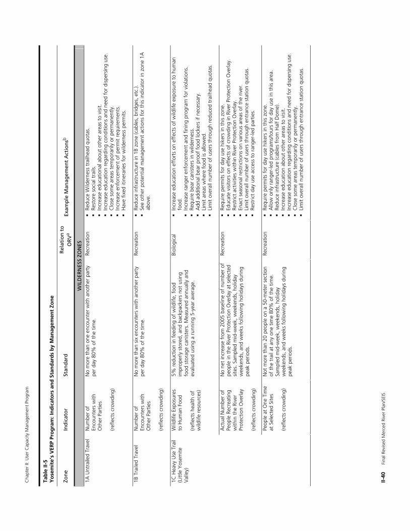
Cha
pter
II: U
ser
Cap
acity
Man
agem
ent
Prog
ram
II-40
F
inal
Rev
ised
Mer
ced
Rive
r Pl
an/S
EIS
Tab
le II
-5
Yo
sem
ite’
s V
ERP
Pro
gra
m: I
nd
icat
ors
an
d S
tan
dar
ds
by
Man
agem
ent
Zon
e
Zon
e In
dic
ato
r St
and
ard
R
elat
ion
to
O
RV
a Ex
amp
le M
anag
emen
t A
ctio
nsb
WIL
DER
NES
S ZO
NES
1A
Unt
raile
d Tr
avel
N
umbe
r of
En
coun
ters
with
O
ther
Par
ties
(ref
lect
s cr
owdi
ng)
No
mor
e th
an o
ne e
ncou
nter
with
ano
ther
par
ty
per
day
80%
of
the
time.
Re
crea
tion
Re
duce
Wild
erne
ss t
railh
ead
quot
as.
Re
stor
e so
cial
tra
ils.
In
crea
se e
duca
tiona
l abo
ut o
ther
are
as t
o vi
sit.
Incr
ease
edu
catio
n re
gard
ing
cond
ition
s an
d ne
ed f
or d
ispe
rsin
g us
e.
C
lose
som
e ar
eas
tem
pora
rily
or p
erm
anen
tly.
In
crea
se e
nfor
cem
ent
of p
erm
it re
quire
men
ts.
H
ave
fixed
itin
erar
ies
for
wild
erne
ss p
erm
its.
1B
Tra
iled
Trav
el
Num
ber
of
Enco
unte
rs w
ith
Oth
er P
artie
s (r
efle
cts
crow
ding
)
No
mor
e th
an s
ix e
ncou
nter
s w
ith a
noth
er p
arty
pe
r da
y 80
% o
f th
e tim
e.
Recr
eatio
n
Redu
ce in
fras
truc
ture
in 1
B zo
ne (c
able
s, b
ridge
s, e
tc.).
See
othe
r po
tent
ial m
anag
emen
t ac
tions
for
thi
s in
dica
tor
in z
one
1A
abov
e.
Wild
life
Expo
sure
s to
Hum
an F
ood
(ref
lect
s he
alth
of
wild
life
reso
urce
s)
5% r
educ
tion
in f
eedi
ng o
f w
ildlif
e, f
ood
impr
oper
ly s
tore
d, a
nd b
ackp
acke
rs n
ot u
sing
fo
od s
tora
ge c
anis
ters
. Mea
sure
d an
nual
ly a
nd
eval
uate
d us
ing
a ru
nnin
g 5-
year
ave
rage
.
Biol
ogic
al
In
crea
se e
duca
tion
effo
rts
on e
ffec
ts o
f w
ildlif
e ex
posu
re t
o hu
man
fo
od.
In
crea
se r
ange
r en
forc
emen
t an
d fin
ing
prog
ram
for
vio
latio
ns.
Re
quire
bea
r ca
nist
ers
in w
ilder
ness
.
Add
add
ition
al b
ear
proo
f fo
od lo
cker
s if
nece
ssar
y.
Li
mit
area
s w
here
foo
d is
allo
wed
.
Lim
it ov
eral
l num
ber
of u
sers
thr
ough
red
uced
tra
ilhea
d qu
otas
.
Act
ual N
umbe
r of
Pe
ople
Rec
reat
ing
with
in t
he R
iver
Pr
otec
tion
Ove
rlay
(ref
lect
s cr
owdi
ng)
No
net
incr
ease
fro
m 2
005
base
line
of n
umbe
r of
pe
ople
in t
he R
iver
Pro
tect
ion
Ove
rlay
at s
elec
ted
site
s. S
ampl
ed m
id-w
eek,
wee
kend
s, h
olid
ay
wee
kend
s, a
nd w
eeks
fol
low
ing
holid
ays
durin
g pe
ak p
erio
ds.
Recr
eatio
n
Requ
ire p
erm
its f
or d
ay u
se h
iker
s in
thi
s zo
ne.
Ed
ucat
e vi
sito
rs o
n ef
fect
s of
cro
wdi
ng in
Riv
er P
rote
ctio
n O
verla
y.
Re
stric
t ac
tiviti
es w
ithin
Riv
er P
rote
ctio
n O
verla
y.
En
act
seas
onal
res
tric
tions
on
vario
us a
reas
of
the
river
.
Lim
it ov
eral
l num
ber
of u
sers
thr
ough
ent
ranc
e st
atio
n qu
otas
.
Rest
rict
day
use
acce
ss t
o ra
nger
-led
part
ies.
1C H
eavy
Use
Tra
il (L
ittle
Yos
emite
V
alle
y)
Peop
le a
t O
ne T
ime
at S
elec
ted
Site
s
(ref
lect
s cr
owdi
ng)
Not
mor
e th
an 2
0 pe
ople
on
a 50
-met
er s
ectio
n of
the
tra
il at
any
one
tim
e 80
% o
f th
e tim
e.
Sam
pled
mid
-wee
k, w
eeke
nds,
hol
iday
w
eeke
nds,
and
wee
ks f
ollo
win
g ho
liday
s du
ring
peak
per
iods
.
Recr
eatio
n
Requ
ire p
erm
its f
or d
ay u
se h
iker
s in
thi
s zo
ne.
A
llow
onl
y ra
nger
-led
prog
ram
s/to
urs
for
day
use
in t
his
area
.
Redu
ce in
fras
truc
ture
(cab
les
from
Hal
f D
ome)
.
Incr
ease
edu
catio
n ab
out
othe
r ar
eas
to v
isit.
Incr
ease
edu
catio
n re
gard
ing
cond
ition
s an
d ne
ed f
or d
ispe
rsin
g us
e.
C
lose
som
e ar
eas
tem
pora
rily
or p
erm
anen
tly.
Li
mit
over
all n
umbe
r of
use
rs t
hrou
gh e
ntra
nce
stat
ion
quot
as.
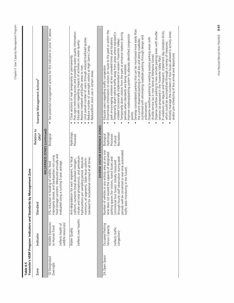
Cha
pter
II: U
ser
Cap
acity
Man
agem
ent
Prog
ram
Fina
l Rev
ised
Mer
ced
Rive
r Pl
an/S
EIS
II
-41
Tab
le II
-5
Yo
sem
ite’
s V
ERP
Pro
gra
m: I
nd
icat
ors
an
d S
tan
dar
ds
by
Man
agem
ent
Zon
e
Zon
e In
dic
ato
r St
and
ard
R
elat
ion
to
O
RV
a Ex
amp
le M
anag
emen
t A
ctio
nsb
WIL
DER
NES
S ZO
NES
(co
nti
nu
ed)
Wild
life
Expo
sure
s to
Hum
an F
ood
(ref
lect
s he
alth
of
wild
life
reso
urce
s)
5% r
educ
tion
in f
eedi
ng o
f w
ildlif
e, f
ood
impr
oper
ly s
tore
d, a
nd b
ackp
acke
rs n
ot u
sing
fo
od s
tora
ge c
anis
ters
. Mea
sure
d an
nual
ly a
nd
eval
uate
d us
ing
a ru
nnin
g 5-
year
ave
rage
.
Biol
ogic
al
Se
e po
tent
ial m
anag
emen
t ac
tions
for
thi
s in
dica
tor
in z
one
1C a
bove
. 1D
Des
igna
ted
Ove
rnig
ht
Wat
er Q
ualit
y (r
efle
cts
river
hea
lth)
Ant
i-deg
rada
tion
for
each
seg
men
t, f
or f
ecal
co
lifor
m, n
utrie
nts
(tot
al d
isso
lved
nitr
ogen
, ni
trat
e an
d to
tal p
hosp
horu
s), a
nd p
etro
leum
hy
droc
arbo
ns p
er s
ampl
ing
perio
d. A
bsol
ute
min
imum
, all
segm
ents
: Sta
te f
ecal
col
iform
st
anda
rd f
or r
ecre
atio
nal c
onta
ct a
t al
l tim
es.
Hyd
rolo
gic
Proc
esse
s
Clo
se s
ectio
ns o
f riv
er t
empo
raril
y or
per
man
ently
.
Post
sig
ns r
estr
ictin
g ac
cess
and
pro
vidi
ng w
ater
qua
lity
info
rmat
ion.
Educ
ate
user
s re
gard
ing
impa
cts
of a
ctiv
ities
on
wat
er q
ualit
y.
Re
stor
e riv
erba
nk a
nd b
uffe
r ar
eas
to r
iver
.
Lim
it ov
eral
l num
ber
of u
sers
thr
ough
red
uced
tra
ilhea
d qu
otas
.
Redu
ce n
umbe
r of
ove
rnig
ht v
isito
rs a
t H
igh
Sier
ra C
amp.
Redu
ce/li
mit
stoc
k us
e in
cer
tain
are
as.
DIV
ERSE
VIS
ITO
R E
XPE
RIE
NC
E ZO
NES
2A
Ope
n Sp
ace
Occ
upie
d Pa
rkin
g V
ersu
s C
apac
ity
(ref
lect
s tr
affic
co
nges
tion)
Num
ber
of v
ehic
les
in a
ny a
ctiv
ity a
rea
at a
ny o
ne
time
does
not
exc
eed
the
capa
city
of
desi
gnat
ed
park
ing
spac
es (f
or v
isito
rs, t
rans
it bu
ses
and
com
mer
cial
tou
r bu
ses)
. Ini
tially
mea
sure
d th
roug
h ho
urly
sta
ff o
bser
vatio
n du
ring
peak
pe
riods
(will
be
conv
erte
d to
rea
l-tim
e au
tom
ated
tr
affic
dat
a m
onito
ring
in t
he f
utur
e).
Biol
ogic
al
Hyd
rolo
gic
Proc
esse
s C
ultu
ral
Recr
eatio
n
Ed
ucat
e us
ers
rega
rdin
g tr
affic
con
gest
ion
D
isse
min
ate
info
rmat
ion
to v
isito
rs e
n ro
ute
to t
he p
ark
or w
ithin
the
pa
rk e
ncou
ragi
ng v
isita
tion
at le
ss c
row
ded
times
and
loca
tions
.
Tem
pora
rily
dive
rt v
ehic
le t
raff
ic a
way
fro
m a
reas
whe
re s
tand
ard
is
viol
ated
(occ
asio
nally
impl
emen
ted
in e
aste
rn Y
osem
ite V
alle
y).
Te
mpo
raril
y di
vert
vis
itors
fro
m t
he p
ark
at e
ntra
nce
stat
ions
dur
ing
perio
ds w
hen
stan
dard
s ar
e be
ing
viol
ated
.
Impr
ove
road
way
/par
king
sys
tem
to
alle
viat
e id
entif
ied
cong
estio
n po
ints
.
Dev
elop
con
solid
ated
par
king
tha
t ca
n be
mon
itore
d m
ore
easi
ly t
han
the
curr
ent
disp
erse
d pa
rkin
g in
sm
all l
ots
and
alon
g ro
adsi
des
(com
bine
d w
ith e
limin
atin
g ro
adsi
de p
arki
ng t
hrou
gh d
esig
n an
d en
forc
emen
t).
D
ispe
rse
over
flow
par
king
to
exis
ting
surp
lus
park
ing
area
s w
ith
shut
tle s
ervi
ce (a
s is
now
don
e at
Mar
ipos
a G
rove
).
Dis
pers
e ov
erflo
w p
arki
ng t
o ne
w r
emot
e pa
rkin
g ar
eas
with
shu
ttle
se
rvic
es (a
s pr
opos
ed in
the
Yos
emite
Val
ley
Plan
).
If vi
olat
ions
are
reg
ular
and
fre
quen
t, im
plem
ent
day
visi
tatio
n lim
its,
whi
ch c
ould
be
acco
mpl
ishe
d th
roug
h a
varie
ty o
f m
easu
res.
Act
ivel
y m
anag
e th
e nu
mbe
rs o
f to
ur b
uses
allo
wed
in a
ctiv
ity a
reas
an
d/or
pre
-sch
edul
ing
of b
us a
rriv
al a
nd d
epar
ture
s.
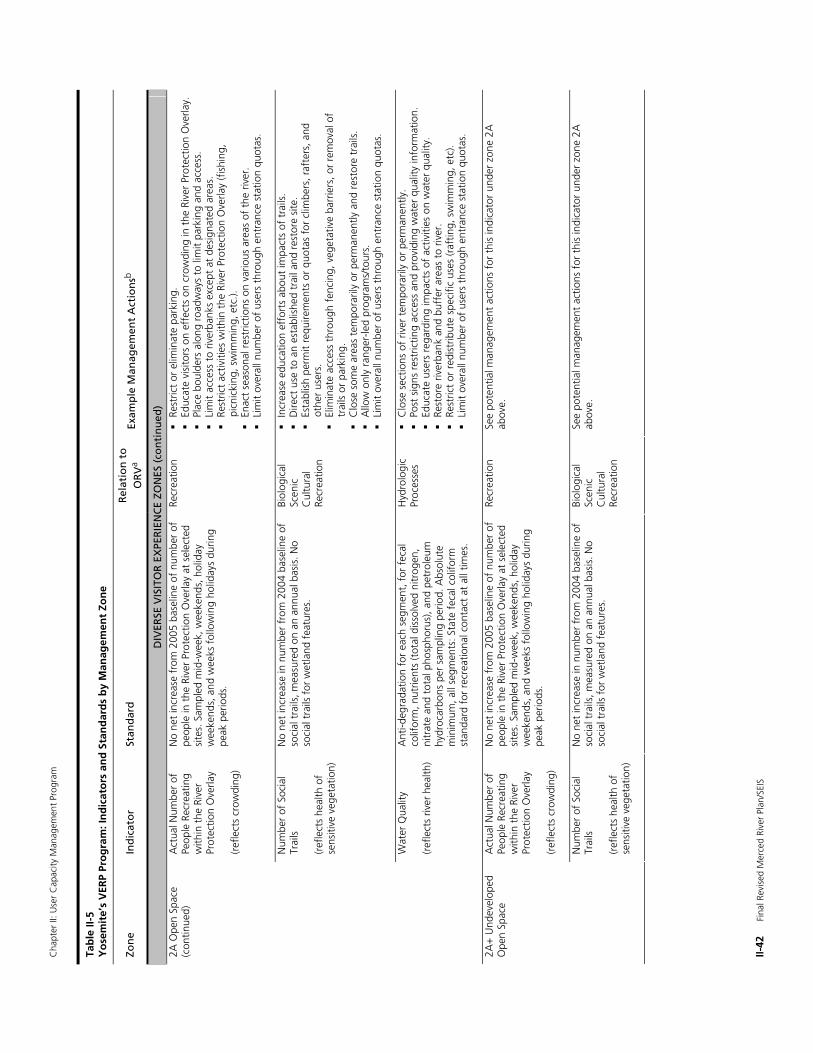
Cha
pter
II: U
ser
Cap
acity
Man
agem
ent
Prog
ram
II-42
F
inal
Rev
ised
Mer
ced
Rive
r Pl
an/S
EIS
Tab
le II
-5
Yo
sem
ite’
s V
ERP
Pro
gra
m: I
nd
icat
ors
an
d S
tan
dar
ds
by
Man
agem
ent
Zon
e
Zon
e In
dic
ato
r St
and
ard
R
elat
ion
to
O
RV
a Ex
amp
le M
anag
emen
t A
ctio
nsb
DIV
ERSE
VIS
ITO
R E
XPE
RIE
NC
E ZO
NES
(co
nti
nu
ed)
2A O
pen
Spac
e (c
ontin
ued)
A
ctua
l Num
ber
of
Peop
le R
ecre
atin
g w
ithin
the
Riv
er
Prot
ectio
n O
verla
y (r
efle
cts
crow
ding
)
No
net
incr
ease
fro
m 2
005
base
line
of n
umbe
r of
pe
ople
in t
he R
iver
Pro
tect
ion
Ove
rlay
at s
elec
ted
site
s. S
ampl
ed m
id-w
eek,
wee
kend
s, h
olid
ay
wee
kend
s, a
nd w
eeks
fol
low
ing
holid
ays
durin
g pe
ak p
erio
ds.
Recr
eatio
n
Rest
rict
or e
limin
ate
park
ing.
Educ
ate
visi
tors
on
effe
cts
on c
row
ding
in t
he R
iver
Pro
tect
ion
Ove
rlay.
Plac
e bo
ulde
rs a
long
roa
dway
s to
lim
it pa
rkin
g an
d ac
cess
.
Lim
it ac
cess
to
river
bank
s ex
cept
at
desi
gnat
ed a
reas
.
Rest
rict
activ
ities
with
in t
he R
iver
Pro
tect
ion
Ove
rlay
(fis
hing
, pi
cnic
king
, sw
imm
ing,
etc
.).
En
act
seas
onal
res
tric
tions
on
vario
us a
reas
of
the
river
.
Lim
it ov
eral
l num
ber
of u
sers
thr
ough
ent
ranc
e st
atio
n qu
otas
.
Num
ber
of S
ocia
l Tr
ails
(r
efle
cts
heal
th o
f se
nsiti
ve v
eget
atio
n)
No
net
incr
ease
in n
umbe
r fr
om 2
004
base
line
of
soci
al t
rails
, mea
sure
d on
an
annu
al b
asis
. No
soci
al t
rails
for
wet
land
fea
ture
s.
Biol
ogic
al
Scen
ic
Cul
tura
l Re
crea
tion
In
crea
se e
duca
tion
effo
rts
abou
t im
pact
s of
tra
ils.
D
irect
use
to
an e
stab
lishe
d tr
ail a
nd r
esto
re s
ite.
Es
tabl
ish
perm
it re
quire
men
ts o
r qu
otas
for
clim
bers
, raf
ters
, and
ot
her
user
s.
El
imin
ate
acce
ss t
hrou
gh f
enci
ng, v
eget
ativ
e ba
rrie
rs, o
r re
mov
al o
f tr
ails
or
park
ing.
Clo
se s
ome
area
s te
mpo
raril
y or
per
man
ently
and
res
tore
tra
ils.
A
llow
onl
y ra
nger
-led
prog
ram
s/to
urs.
Lim
it ov
eral
l num
ber
of u
sers
thr
ough
ent
ranc
e st
atio
n qu
otas
.
Wat
er Q
ualit
y (r
efle
cts
river
hea
lth)
Ant
i-deg
rada
tion
for
each
seg
men
t, f
or f
ecal
co
lifor
m, n
utrie
nts
(tot
al d
isso
lved
nitr
ogen
, ni
trat
e an
d to
tal p
hosp
horu
s), a
nd p
etro
leum
hy
droc
arbo
ns p
er s
ampl
ing
perio
d. A
bsol
ute
min
imum
, all
segm
ents
: Sta
te f
ecal
col
iform
st
anda
rd f
or r
ecre
atio
nal c
onta
ct a
t al
l tim
es.
Hyd
rolo
gic
Proc
esse
s
Clo
se s
ectio
ns o
f riv
er t
empo
raril
y or
per
man
ently
.
Post
sig
ns r
estr
ictin
g ac
cess
and
pro
vidi
ng w
ater
qua
lity
info
rmat
ion.
Educ
ate
user
s re
gard
ing
impa
cts
of a
ctiv
ities
on
wat
er q
ualit
y.
Re
stor
e riv
erba
nk a
nd b
uffe
r ar
eas
to r
iver
.
Rest
rict
or r
edis
trib
ute
spec
ific
uses
(raf
ting,
sw
imm
ing,
etc
).
Lim
it ov
eral
l num
ber
of u
sers
thr
ough
ent
ranc
e st
atio
n qu
otas
.
Act
ual N
umbe
r of
Pe
ople
Rec
reat
ing
with
in t
he R
iver
Pr
otec
tion
Ove
rlay
(ref
lect
s cr
owdi
ng)
No
net
incr
ease
fro
m 2
005
base
line
of n
umbe
r of
pe
ople
in t
he R
iver
Pro
tect
ion
Ove
rlay
at s
elec
ted
site
s. S
ampl
ed m
id-w
eek,
wee
kend
s, h
olid
ay
wee
kend
s, a
nd w
eeks
fol
low
ing
holid
ays
durin
g pe
ak p
erio
ds.
Recr
eatio
n Se
e po
tent
ial m
anag
emen
t ac
tions
for
thi
s in
dica
tor
unde
r zo
ne 2
A
abov
e.
2A+
Und
evel
oped
O
pen
Spac
e
Num
ber
of S
ocia
l Tr
ails
(r
efle
cts
heal
th o
f se
nsiti
ve v
eget
atio
n)
No
net
incr
ease
in n
umbe
r fr
om 2
004
base
line
of
soci
al t
rails
, mea
sure
d on
an
annu
al b
asis
. No
soci
al t
rails
for
wet
land
fea
ture
s.
Biol
ogic
al
Scen
ic
Cul
tura
l Re
crea
tion
See
pote
ntia
l man
agem
ent
actio
ns f
or t
his
indi
cato
r un
der
zone
2A
ab
ove.
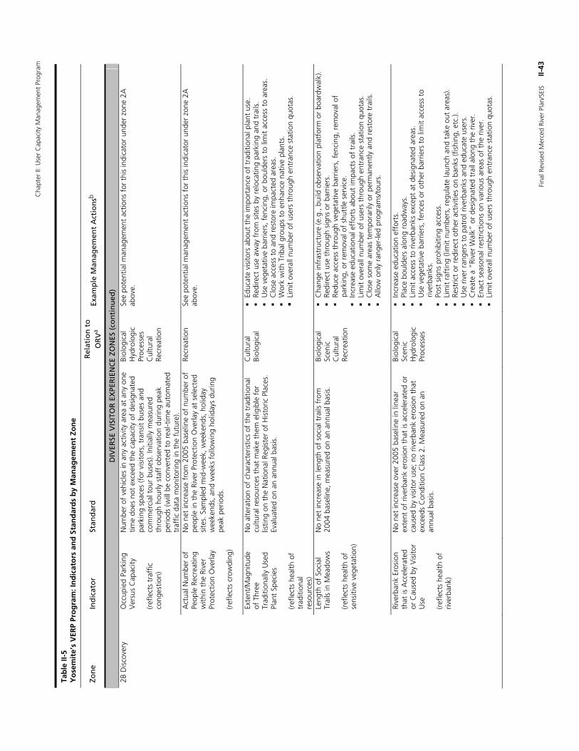
Cha
pter
II: U
ser
Cap
acity
Man
agem
ent
Prog
ram
Fina
l Rev
ised
Mer
ced
Rive
r Pl
an/S
EIS
II
-43
Tab
le II
-5
Yo
sem
ite’
s V
ERP
Pro
gra
m: I
nd
icat
ors
an
d S
tan
dar
ds
by
Man
agem
ent
Zon
e
Zon
e In
dic
ato
r St
and
ard
R
elat
ion
to
O
RV
a Ex
amp
le M
anag
emen
t A
ctio
nsb
DIV
ERSE
VIS
ITO
R E
XPE
RIE
NC
E ZO
NES
(co
nti
nu
ed)
2B D
isco
very
O
ccup
ied
Park
ing
Ver
sus
Cap
acity
(r
efle
cts
traf
fic
cong
estio
n)
Num
ber
of v
ehic
les
in a
ny a
ctiv
ity a
rea
at a
ny o
ne
time
does
not
exc
eed
the
capa
city
of
desi
gnat
ed
park
ing
spac
es (f
or v
isito
rs, t
rans
it bu
ses
and
com
mer
cial
tou
r bu
ses)
. Ini
tially
mea
sure
d th
roug
h ho
urly
sta
ff o
bser
vatio
n du
ring
peak
pe
riods
(will
be
conv
erte
d to
rea
l-tim
e au
tom
ated
tr
affic
dat
a m
onito
ring
in t
he f
utur
e).
Biol
ogic
al
Hyd
rolo
gic
Proc
esse
s C
ultu
ral
Recr
eatio
n
See
pote
ntia
l man
agem
ent
actio
ns f
or t
his
indi
cato
r un
der
zone
2A
ab
ove.
A
ctua
l Num
ber
of
Peop
le R
ecre
atin
g w
ithin
the
Riv
er
Prot
ectio
n O
verla
y (r
efle
cts
crow
ding
)
No
net
incr
ease
fro
m 2
005
base
line
of n
umbe
r of
pe
ople
in t
he R
iver
Pro
tect
ion
Ove
rlay
at s
elec
ted
site
s. S
ampl
ed m
id-w
eek,
wee
kend
s, h
olid
ay
wee
kend
s, a
nd w
eeks
fol
low
ing
holid
ays
durin
g pe
ak p
erio
ds.
Recr
eatio
n Se
e po
tent
ial m
anag
emen
t ac
tions
for
thi
s in
dica
tor
unde
r zo
ne 2
A
abov
e.
Ex
tent
/Mag
nitu
de
of T
hree
Tr
aditi
onal
ly U
sed
Plan
t Sp
ecie
s (r
efle
cts
heal
th o
f tr
aditi
onal
re
sour
ces)
No
alte
ratio
n of
cha
ract
eris
tics
of t
he t
radi
tiona
l cu
ltura
l res
ourc
es t
hat
mak
e th
em e
ligib
le f
or
listin
g on
the
Nat
iona
l Reg
iste
r of
His
toric
Pla
ces.
Ev
alua
ted
on a
n an
nual
bas
is.
Cul
tura
l Bi
olog
ical
Educ
ate
visi
tors
abo
ut t
he im
port
ance
of
trad
ition
al p
lant
use
.
Redi
rect
use
aw
ay f
rom
site
s by
rel
ocat
ing
park
ing
and
trai
ls.
U
se v
eget
ativ
e ba
rrie
rs, f
enci
ng, o
r bo
ulde
rs t
o lim
it ac
cess
to
area
s.
C
lose
acc
ess
to a
nd r
esto
re im
pact
ed a
reas
.
Wor
k w
ith T
ribal
gro
ups
to e
nhan
ce n
ativ
e pl
ants
. L
imit
over
all n
umbe
r of
use
rs t
hrou
gh e
ntra
nce
stat
ion
quot
as.
Le
ngth
of
Soci
al
Trai
ls in
Mea
dow
s (r
efle
cts
heal
th o
f se
nsiti
ve v
eget
atio
n)
No
net
incr
ease
in le
ngth
of
soci
al t
rails
fro
m
2004
bas
elin
e, m
easu
red
on a
n an
nual
bas
is.
Biol
ogic
al
Scen
ic
Cul
tura
l Re
crea
tion
C
hang
e in
fras
truc
ture
(e.g
., bu
ild o
bser
vatio
n pl
atfo
rm o
r bo
ardw
alk)
.
Redi
rect
use
thr
ough
sig
ns o
r ba
rrie
rs.
Re
duce
acc
ess
thro
ugh
vege
tativ
e ba
rrie
rs, f
enci
ng, r
emov
al o
f pa
rkin
g, o
r re
mov
al o
f sh
uttle
ser
vice
.
Incr
ease
edu
catio
nal e
ffor
ts a
bout
impa
cts
of t
rails
.
Lim
it ov
eral
l num
ber
of u
sers
thr
ough
ent
ranc
e st
atio
n qu
otas
.
Clo
se s
ome
area
s te
mpo
raril
y or
per
man
ently
and
res
tore
tra
ils.
A
llow
onl
y ra
nger
-led
prog
ram
s/to
urs.
Ri
verb
ank
Eros
ion
that
is A
ccel
erat
ed
or C
ause
d by
Vis
itor
Use
(r
efle
cts
heal
th o
f riv
erba
nk)
No
net
incr
ease
ove
r 20
05 b
asel
ine
in li
near
ex
tent
of
river
bank
ero
sion
tha
t is
acc
eler
ated
or
caus
ed b
y vi
sito
r us
e; n
o riv
erba
nk e
rosi
on t
hat
exce
eds
Con
ditio
n C
lass
2. M
easu
red
on a
n an
nual
bas
is.
Biol
ogic
al
Scen
ic
Hyd
rolo
gic
Proc
esse
s
In
crea
se e
duca
tion
effo
rts.
Plac
e bo
ulde
rs a
long
roa
dway
s.
Li
mit
acce
ss t
o riv
erba
nks
exce
pt a
t de
sign
ated
are
as.
U
se v
eget
ativ
e ba
rrie
rs, f
ence
s or
oth
er b
arrie
rs t
o lim
it ac
cess
to
river
bank
s.
Po
st s
igns
pro
hibi
ting
acce
ss.
Li
mit
raft
ing
(lim
it nu
mbe
rs, r
egul
ate
laun
ch a
nd t
ake
out
area
s).
Re
stric
t or
red
irect
oth
er a
ctiv
ities
on
bank
s (f
ishi
ng, e
tc.).
Use
riv
er r
ange
rs t
o pa
trol
riv
erba
nks
and
educ
ate
user
s.
C
reat
e a
“Riv
er W
alk”
or
desi
gnat
ed t
rail
alon
g th
e riv
er.
En
act
seas
onal
res
tric
tions
on
vario
us a
reas
of
the
river
.
Lim
it ov
eral
l num
ber
of u
sers
thr
ough
ent
ranc
e st
atio
n qu
otas
.
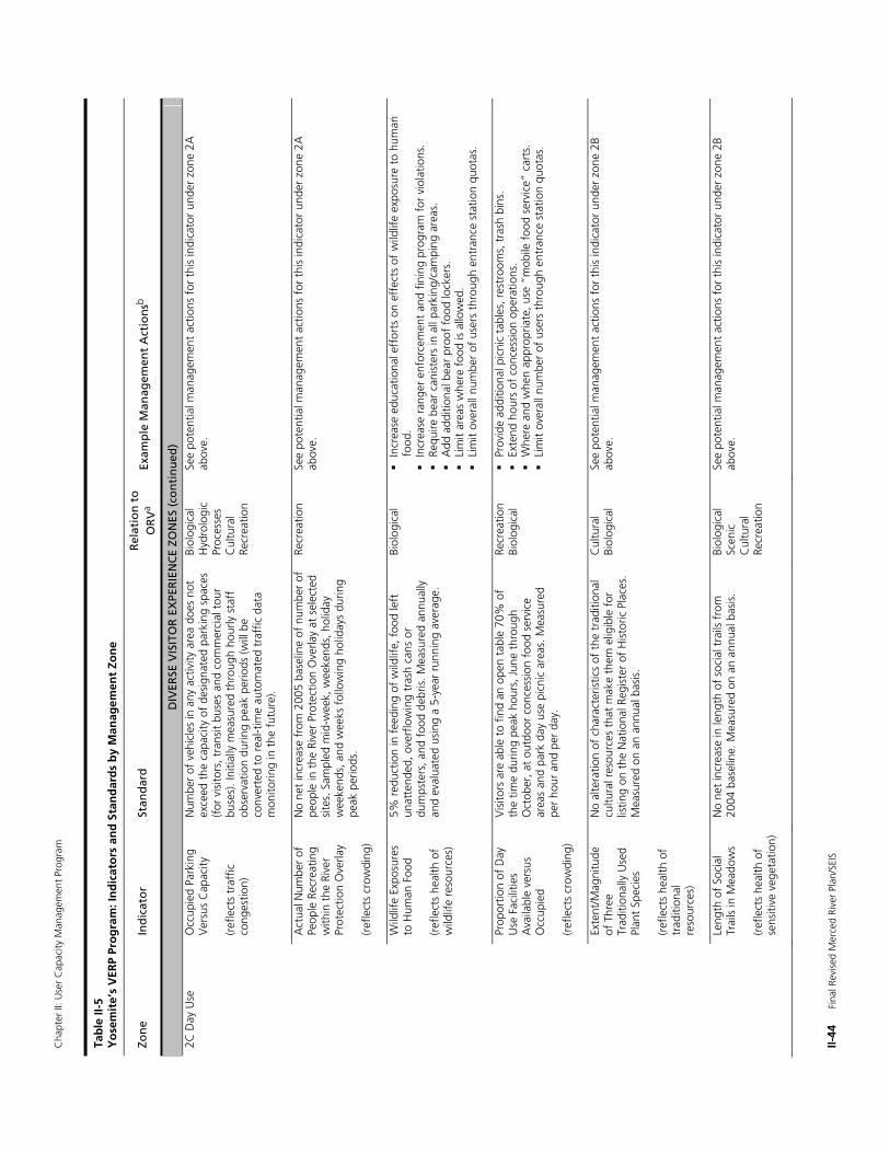
Cha
pter
II: U
ser
Cap
acity
Man
agem
ent
Prog
ram
II-44
F
inal
Rev
ised
Mer
ced
Rive
r Pl
an/S
EIS
Tab
le II
-5
Yo
sem
ite’
s V
ERP
Pro
gra
m: I
nd
icat
ors
an
d S
tan
dar
ds
by
Man
agem
ent
Zon
e
Zon
e In
dic
ato
r St
and
ard
R
elat
ion
to
O
RV
a Ex
amp
le M
anag
emen
t A
ctio
nsb
DIV
ERSE
VIS
ITO
R E
XPE
RIE
NC
E ZO
NES
(co
nti
nu
ed)
2C D
ay U
se
Occ
upie
d Pa
rkin
g V
ersu
s C
apac
ity
(ref
lect
s tr
affic
co
nges
tion)
Num
ber
of v
ehic
les
in a
ny a
ctiv
ity a
rea
does
not
ex
ceed
the
cap
acity
of
desi
gnat
ed p
arki
ng s
pace
s (f
or v
isito
rs, t
rans
it bu
ses
and
com
mer
cial
tou
r bu
ses)
. Ini
tially
mea
sure
d th
roug
h ho
urly
sta
ff
obse
rvat
ion
durin
g pe
ak p
erio
ds (w
ill b
e co
nver
ted
to r
eal-t
ime
auto
mat
ed t
raff
ic d
ata
mon
itorin
g in
the
fut
ure)
.
Biol
ogic
al
Hyd
rolo
gic
Proc
esse
s C
ultu
ral
Recr
eatio
n
See
pote
ntia
l man
agem
ent
actio
ns f
or t
his
indi
cato
r un
der
zone
2A
ab
ove.
A
ctua
l Num
ber
of
Peop
le R
ecre
atin
g w
ithin
the
Riv
er
Prot
ectio
n O
verla
y (r
efle
cts
crow
ding
)
No
net
incr
ease
fro
m 2
005
base
line
of n
umbe
r of
pe
ople
in t
he R
iver
Pro
tect
ion
Ove
rlay
at s
elec
ted
site
s. S
ampl
ed m
id-w
eek,
wee
kend
s, h
olid
ay
wee
kend
s, a
nd w
eeks
fol
low
ing
holid
ays
durin
g pe
ak p
erio
ds.
Recr
eatio
n Se
e po
tent
ial m
anag
emen
t ac
tions
for
thi
s in
dica
tor
unde
r zo
ne 2
A
abov
e.
W
ildlif
e Ex
posu
res
to H
uman
Foo
d (r
efle
cts
heal
th o
f w
ildlif
e re
sour
ces)
5% r
educ
tion
in f
eedi
ng o
f w
ildlif
e, f
ood
left
un
atte
nded
, ove
rflo
win
g tr
ash
cans
or
dum
pste
rs, a
nd f
ood
debr
is. M
easu
red
annu
ally
an
d ev
alua
ted
usin
g a
5-ye
ar r
unni
ng a
vera
ge.
Biol
ogic
al
In
crea
se e
duca
tiona
l eff
orts
on
effe
cts
of w
ildlif
e ex
posu
re t
o hu
man
fo
od.
In
crea
se r
ange
r en
forc
emen
t an
d fin
ing
prog
ram
for
vio
latio
ns.
Re
quire
bea
r ca
nist
ers
in a
ll pa
rkin
g/ca
mpi
ng a
reas
.
Add
add
ition
al b
ear
proo
f fo
od lo
cker
s.
Li
mit
area
s w
here
foo
d is
allo
wed
.
Lim
it ov
eral
l num
ber
of u
sers
thr
ough
ent
ranc
e st
atio
n qu
otas
.
Pr
opor
tion
of D
ay
Use
Fac
ilitie
s A
vaila
ble
vers
us
Occ
upie
d (r
efle
cts
crow
ding
)
Vis
itors
are
abl
e to
fin
d an
ope
n ta
ble
70%
of
the
time
durin
g pe
ak h
ours
, Jun
e th
roug
h O
ctob
er, a
t ou
tdoo
r co
nces
sion
foo
d se
rvic
e ar
eas
and
park
day
use
pic
nic
area
s. M
easu
red
per
hour
and
per
day
.
Recr
eatio
n Bi
olog
ical
Prov
ide
addi
tiona
l pic
nic
tabl
es, r
estr
oom
s, t
rash
bin
s.
Ex
tend
hou
rs o
f co
nces
sion
ope
ratio
ns.
W
here
and
whe
n ap
prop
riate
, use
“m
obile
foo
d se
rvic
e” c
arts
.
Lim
it ov
eral
l num
ber
of u
sers
thr
ough
ent
ranc
e st
atio
n qu
otas
.
Ex
tent
/Mag
nitu
de
of T
hree
Tr
aditi
onal
ly U
sed
Plan
t Sp
ecie
s (r
efle
cts
heal
th o
f tr
aditi
onal
re
sour
ces)
No
alte
ratio
n of
cha
ract
eris
tics
of t
he t
radi
tiona
l cu
ltura
l res
ourc
es t
hat
mak
e th
em e
ligib
le f
or
listin
g on
the
Nat
iona
l Reg
iste
r of
His
toric
Pla
ces.
M
easu
red
on a
n an
nual
bas
is.
Cul
tura
l Bi
olog
ical
Se
e po
tent
ial m
anag
emen
t ac
tions
for
thi
s in
dica
tor
unde
r zo
ne 2
B ab
ove.
Le
ngth
of
Soci
al
Trai
ls in
Mea
dow
s (r
efle
cts
heal
th o
f se
nsiti
ve v
eget
atio
n)
No
net
incr
ease
in le
ngth
of
soci
al t
rails
fro
m
2004
bas
elin
e. M
easu
red
on a
n an
nual
bas
is.
Biol
ogic
al
Scen
ic
Cul
tura
l Re
crea
tion
See
pote
ntia
l man
agem
ent
actio
ns f
or t
his
indi
cato
r un
der
zone
2B
abov
e.
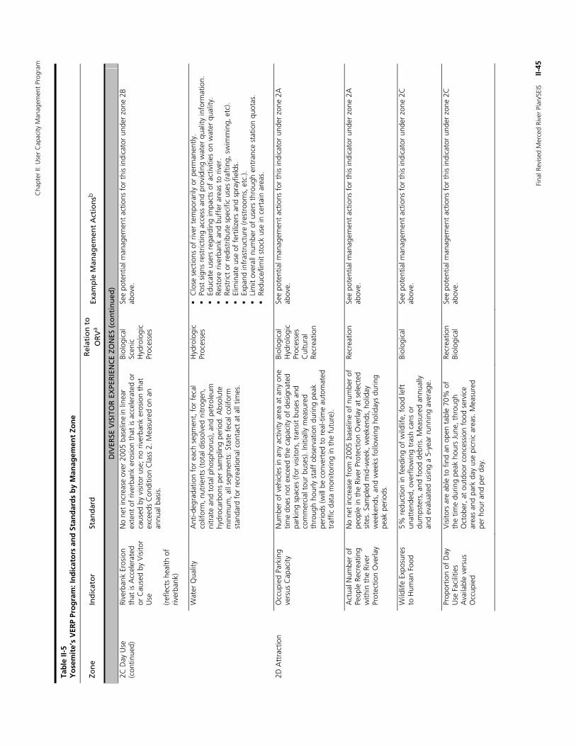
Cha
pter
II: U
ser
Cap
acity
Man
agem
ent
Prog
ram
Fina
l Rev
ised
Mer
ced
Rive
r Pl
an/S
EIS
II
-45
Tab
le II
-5
Yo
sem
ite’
s V
ERP
Pro
gra
m: I
nd
icat
ors
an
d S
tan
dar
ds
by
Man
agem
ent
Zon
e
Zon
e In
dic
ato
r St
and
ard
R
elat
ion
to
O
RV
a Ex
amp
le M
anag
emen
t A
ctio
nsb
DIV
ERSE
VIS
ITO
R E
XPE
RIE
NC
E ZO
NES
(co
nti
nu
ed)
2C D
ay U
se
(con
tinue
d)
Rive
rban
k Er
osio
n th
at is
Acc
eler
ated
or
Cau
sed
by V
isito
r U
se
(ref
lect
s he
alth
of
river
bank
)
No
net
incr
ease
ove
r 20
05 b
asel
ine in
line
ar
exte
nt o
f riv
erba
nk e
rosi
on t
hat
is a
ccel
erat
ed o
r ca
used
by
visi
tor
use;
no
river
bank
ero
sion
tha
t ex
ceed
s C
ondi
tion
Cla
ss 2
. Mea
sure
d on
an
annu
al b
asis
.
Biol
ogic
al
Scen
ic
Hyd
rolo
gic
Proc
esse
s
See
pote
ntia
l man
agem
ent
actio
ns f
or t
his
indi
cato
r un
der
zone
2B
abov
e.
W
ater
Qua
lity
Ant
i-deg
rada
tion
for
each
seg
men
t, f
or f
ecal
co
lifor
m, n
utrie
nts
(tot
al d
isso
lved
nitr
ogen
, ni
trat
e an
d to
tal p
hosp
horu
s), a
nd p
etro
leum
hy
droc
arbo
ns p
er s
ampl
ing
perio
d. A
bsol
ute
min
imum
, all
segm
ents
: Sta
te f
ecal
col
iform
st
anda
rd f
or r
ecre
atio
nal c
onta
ct a
t al
l tim
es.
Hyd
rolo
gic
Proc
esse
s
Clo
se s
ectio
ns o
f riv
er t
empo
raril
y or
per
man
ently
.
Post
sig
ns r
estr
ictin
g ac
cess
and
pro
vidi
ng w
ater
qua
lity
info
rmat
ion.
Educ
ate
user
s re
gard
ing
impa
cts
of a
ctiv
ities
on
wat
er q
ualit
y.
Re
stor
e riv
erba
nk a
nd b
uffe
r ar
eas
to r
iver
.
Rest
rict
or r
edis
trib
ute
spec
ific
uses
(raf
ting,
sw
imm
ing,
etc
).
Elim
inat
e us
e of
fer
tiliz
ers
and
spra
yfie
lds.
Expa
nd in
fras
truc
ture
(res
troo
ms,
etc
.).
Li
mit
over
all n
umbe
r of
use
rs t
hrou
gh e
ntra
nce
stat
ion
quot
as.
Re
duce
/lim
it st
ock
use
in c
erta
in a
reas
.
2D A
ttra
ctio
n O
ccup
ied
Park
ing
vers
us C
apac
ity
Num
ber
of v
ehic
les
in a
ny a
ctiv
ity a
rea
at a
ny o
ne
time
does
not
exc
eed
the
capa
city
of
desi
gnat
ed
park
ing
spac
es (f
or v
isito
rs, t
rans
it bu
ses
and
com
mer
cial
tou
r bu
ses)
. Ini
tially
mea
sure
d th
roug
h ho
urly
sta
ff o
bser
vatio
n du
ring
peak
pe
riods
(will
be
conv
erte
d to
rea
l-tim
e au
tom
ated
tr
affic
dat
a m
onito
ring
in t
he f
utur
e).
Biol
ogic
al
Hyd
rolo
gic
Proc
esse
s C
ultu
ral
Recr
eatio
n
See
pote
ntia
l man
agem
ent
actio
ns f
or t
his
indi
cato
r un
der
zone
2A
ab
ove.
A
ctua
l Num
ber
of
Peop
le R
ecre
atin
g w
ithin
the
Riv
er
Prot
ectio
n O
verla
y
No
net
incr
ease
fro
m 2
005
base
line
of n
umbe
r of
pe
ople
in t
he R
iver
Pro
tect
ion
Ove
rlay
at s
elec
ted
site
s. S
ampl
ed m
id-w
eek,
wee
kend
s, h
olid
ay
wee
kend
s, a
nd w
eeks
fol
low
ing
holid
ays
durin
g pe
ak p
erio
ds.
Recr
eatio
n Se
e po
tent
ial m
anag
emen
t ac
tions
for
thi
s in
dica
tor
unde
r zo
ne 2
A
abov
e.
W
ildlif
e Ex
posu
res
to H
uman
Foo
d 5%
red
uctio
n in
fee
ding
of
wild
life,
foo
d le
ft
unat
tend
ed, o
verf
low
ing
tras
h ca
ns o
r du
mps
ters
, and
foo
d de
bris
. Mea
sure
d an
nual
ly
and
eval
uate
d us
ing
a 5-
year
run
ning
ave
rage
.
Biol
ogic
al
See
pote
ntia
l man
agem
ent
actio
ns f
or t
his
indi
cato
r un
der
zone
2C
ab
ove.
Pr
opor
tion
of D
ay
Use
Fac
ilitie
s A
vaila
ble
vers
us
Occ
upie
d
Vis
itors
are
abl
e to
fin
d an
ope
n ta
ble
70%
of
the
time
durin
g pe
ak h
ours
Jun
e, t
hrou
gh
Oct
ober
, at
outd
oor
conc
essi
on f
ood
serv
ice
area
s an
d pa
rk d
ay u
se p
icni
c ar
eas.
Mea
sure
d pe
r ho
ur a
nd p
er d
ay.
Recr
eatio
n Bi
olog
ical
Se
e po
tent
ial m
anag
emen
t ac
tions
for
thi
s in
dica
tor
unde
r zo
ne 2
C
abov
e.
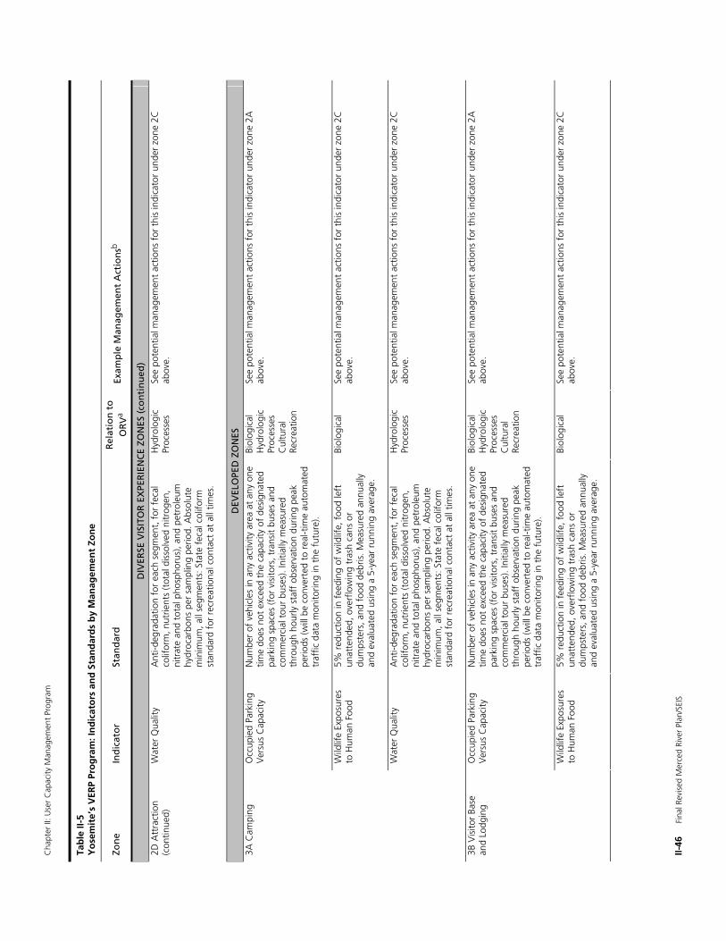
Cha
pter
II: U
ser
Cap
acity
Man
agem
ent
Prog
ram
II-46
F
inal
Rev
ised
Mer
ced
Rive
r Pl
an/S
EIS
Tab
le II
-5
Yo
sem
ite’
s V
ERP
Pro
gra
m: I
nd
icat
ors
an
d S
tan
dar
ds
by
Man
agem
ent
Zon
e
Zon
e In
dic
ato
r St
and
ard
R
elat
ion
to
O
RV
a Ex
amp
le M
anag
emen
t A
ctio
nsb
DIV
ERSE
VIS
ITO
R E
XPE
RIE
NC
E ZO
NES
(co
nti
nu
ed)
2D A
ttra
ctio
n (c
ontin
ued)
W
ater
Qua
lity
Ant
i-deg
rada
tion
for
each
seg
men
t, f
or f
ecal
co
lifor
m, n
utrie
nts
(tot
al d
isso
lved
nitr
ogen
, ni
trat
e an
d to
tal p
hosp
horu
s), a
nd p
etro
leum
hy
droc
arbo
ns p
er s
ampl
ing
perio
d. A
bsol
ute
min
imum
, all
segm
ents
: Sta
te f
ecal
col
iform
st
anda
rd f
or r
ecre
atio
nal c
onta
ct a
t al
l tim
es.
Hyd
rolo
gic
Proc
esse
s Se
e po
tent
ial m
anag
emen
t ac
tions
for
thi
s in
dica
tor
unde
r zo
ne 2
C
abov
e.
DEV
ELO
PED
ZO
NES
3A
Cam
ping
O
ccup
ied
Park
ing
Ver
sus
Cap
acity
N
umbe
r of
veh
icle
s in
any
act
ivity
are
a at
any
one
tim
e do
es n
ot e
xcee
d th
e ca
paci
ty o
f de
sign
ated
pa
rkin
g sp
aces
(for
vis
itors
, tra
nsit
buse
s an
d co
mm
erci
al t
our
buse
s). I
nitia
lly m
easu
red
thro
ugh
hour
ly s
taff
obs
erva
tion
durin
g pe
ak
perio
ds (w
ill b
e co
nver
ted
to r
eal-t
ime
auto
mat
ed
traf
fic d
ata
mon
itorin
g in
the
fut
ure)
.
Biol
ogic
al
Hyd
rolo
gic
Proc
esse
s C
ultu
ral
Recr
eatio
n
See
pote
ntia
l man
agem
ent
actio
ns f
or t
his
indi
cato
r un
der
zone
2A
ab
ove.
W
ildlif
e Ex
posu
res
to H
uman
Foo
d 5%
red
uctio
n in
fee
ding
of
wild
life,
foo
d le
ft
unat
tend
ed, o
verf
low
ing
tras
h ca
ns o
r du
mps
ters
, and
foo
d de
bris
. Mea
sure
d an
nual
ly
and
eval
uate
d us
ing
a 5-
year
run
ning
ave
rage
.
Biol
ogic
al
See
pote
ntia
l man
agem
ent
actio
ns f
or t
his
indi
cato
r un
der
zone
2C
ab
ove.
W
ater
Qua
lity
Ant
i-deg
rada
tion
for
each
seg
men
t, f
or f
ecal
co
lifor
m, n
utrie
nts
(tot
al d
isso
lved
nitr
ogen
, ni
trat
e an
d to
tal p
hosp
horu
s), a
nd p
etro
leum
hy
droc
arbo
ns p
er s
ampl
ing
perio
d. A
bsol
ute
min
imum
, all
segm
ents
: Sta
te f
ecal
col
iform
st
anda
rd f
or r
ecre
atio
nal c
onta
ct a
t al
l tim
es.
Hyd
rolo
gic
Proc
esse
s Se
e po
tent
ial m
anag
emen
t ac
tions
for
thi
s in
dica
tor
unde
r zo
ne 2
C
abov
e.
Occ
upie
d Pa
rkin
g V
ersu
s C
apac
ity
Num
ber
of v
ehic
les
in a
ny a
ctiv
ity a
rea
at a
ny o
ne
time
does
not
exc
eed
the
capa
city
of
desi
gnat
ed
park
ing
spac
es (f
or v
isito
rs, t
rans
it bu
ses
and
com
mer
cial
tou
r bu
ses)
. Ini
tially
mea
sure
d th
roug
h ho
urly
sta
ff o
bser
vatio
n du
ring
peak
pe
riods
(will
be
conv
erte
d to
rea
l-tim
e au
tom
ated
tr
affic
dat
a m
onito
ring
in t
he f
utur
e).
Biol
ogic
al
Hyd
rolo
gic
Proc
esse
s C
ultu
ral
Recr
eatio
n
See
pote
ntia
l man
agem
ent
actio
ns f
or t
his
indi
cato
r un
der
zone
2A
ab
ove.
3B
Vis
itor
Base
an
d Lo
dgin
g
Wild
life
Expo
sure
s to
Hum
an F
ood
5% r
educ
tion
in f
eedi
ng o
f w
ildlif
e, f
ood
left
un
atte
nded
, ove
rflo
win
g tr
ash
cans
or
dum
pste
rs, a
nd f
ood
debr
is. M
easu
red
annu
ally
an
d ev
alua
ted
usin
g a
5-ye
ar r
unni
ng a
vera
ge.
Biol
ogic
al
See
pote
ntia
l man
agem
ent
actio
ns f
or t
his
indi
cato
r un
der
zone
2C
ab
ove.
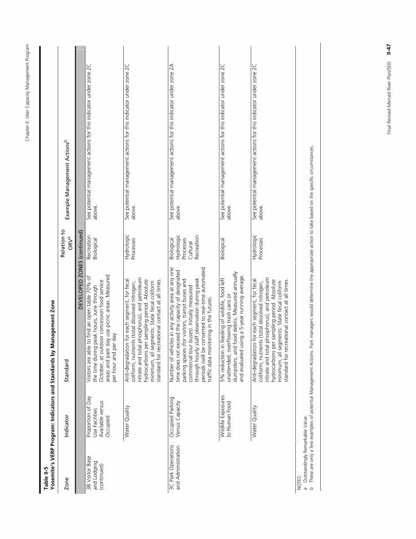
Cha
pter
II: U
ser
Cap
acity
Man
agem
ent
Prog
ram
Fina
l Rev
ised
Mer
ced
Rive
r Pl
an/S
EIS
II
-47
Tab
le II
-5
Yo
sem
ite’
s V
ERP
Pro
gra
m: I
nd
icat
ors
an
d S
tan
dar
ds
by
Man
agem
ent
Zon
e
Zon
e In
dic
ato
r St
and
ard
R
elat
ion
to
O
RV
a Ex
amp
le M
anag
emen
t A
ctio
nsb
DEV
ELO
PED
ZO
NES
(co
nti
nu
ed)
Prop
ortio
n of
Day
U
se F
acili
ties
Ava
ilabl
e ve
rsus
O
ccup
ied
Vis
itors
are
abl
e to
fin
d an
ope
n ta
ble
70%
of
the
time
durin
g pe
ak h
ours
, Jun
e th
roug
h O
ctob
er, a
t ou
tdoo
r co
nces
sion
foo
d se
rvic
e ar
eas
and
park
day
use
pic
nic
area
s. M
easu
red
per
hour
and
per
day
.
Recr
eatio
n Bi
olog
ical
Se
e po
tent
ial m
anag
emen
t ac
tions
for
thi
s in
dica
tor
unde
r zo
ne 2
C
abov
e.
3B V
isito
r Ba
se
and
Lodg
ing
(con
tinue
d)
Wat
er Q
ualit
y A
nti-d
egra
datio
n fo
r ea
ch s
egm
ent,
for
fec
al
colif
orm
, nut
rient
s (t
otal
dis
solv
ed n
itrog
en,
nitr
ate
and
tota
l pho
spho
rus)
, and
pet
role
um
hydr
ocar
bons
per
sam
plin
g pe
riod.
Abs
olut
e m
inim
um, a
ll se
gmen
ts: S
tate
fec
al c
olifo
rm
stan
dard
for
rec
reat
iona
l con
tact
at
all t
imes
.
Hyd
rolo
gic
Proc
esse
s Se
e po
tent
ial m
anag
emen
t ac
tions
for
thi
s in
dica
tor
unde
r zo
ne 2
C
abov
e.
Occ
upie
d Pa
rkin
g V
ersu
s C
apac
ity
Num
ber
of v
ehic
les
in a
ny a
ctiv
ity a
rea
at a
ny o
ne
time
does
not
exc
eed
the
capa
city
of
desi
gnat
ed
park
ing
spac
es (f
or v
isito
rs, t
rans
it bu
ses
and
com
mer
cial
tou
r bu
ses)
. Ini
tially
mea
sure
d th
roug
h ho
urly
sta
ff o
bser
vatio
n du
ring
peak
pe
riods
(will
be
conv
erte
d to
rea
l-tim
e au
tom
ated
tr
affic
dat
a m
onito
ring
in t
he f
utur
e).
Biol
ogic
al
Hyd
rolo
gic
Proc
esse
s C
ultu
ral
Recr
eatio
n
See
pote
ntia
l man
agem
ent
actio
ns f
or t
his
indi
cato
r un
der
zone
2A
ab
ove.
Wild
life
Expo
sure
s to
Hum
an F
ood
5% r
educ
tion
in f
eedi
ng o
f w
ildlif
e, f
ood
left
un
atte
nded
, ove
rflo
win
g tr
ash
cans
or
dum
pste
rs, a
nd f
ood
debr
is. M
easu
red
annu
ally
an
d ev
alua
ted
usin
g a
5-ye
ar r
unni
ng a
vera
ge.
Biol
ogic
al
See
pote
ntia
l man
agem
ent
actio
ns f
or t
his
indi
cato
r un
der
zone
2C
ab
ove.
3C P
ark
Ope
ratio
ns
and
Adm
inis
trat
ion
Wat
er Q
ualit
y A
nti-d
egra
datio
n fo
r ea
ch s
egm
ent,
for
fec
al
colif
orm
, nut
rient
s (t
otal
dis
solv
ed n
itrog
en,
nitr
ate
and
tota
l pho
spho
rus)
, and
pet
role
um
hydr
ocar
bons
per
sam
plin
g pe
riod.
Abs
olut
e m
inim
um, a
ll se
gmen
ts: S
tate
fec
al c
olifo
rm
stan
dard
for
rec
reat
iona
l con
tact
at
all t
imes
.
Hyd
rolo
gic
Proc
esse
s Se
e po
tent
ial m
anag
emen
t ac
tions
for
thi
s in
dica
tor
unde
r zo
ne 2
C
abov
e.
NO
TES:
a
Out
stan
ding
ly R
emar
kabl
e V
alue
. b
Thes
e ar
e on
ly a
few
exa
mpl
es o
f po
tent
ial M
anag
emen
t A
ctio
ns. P
ark
man
ager
s w
ould
det
erm
ine
the
appr
opria
te a
ctio
n to
tak
e ba
sed
on t
he s
peci
fic c
ircum
stan
ces.
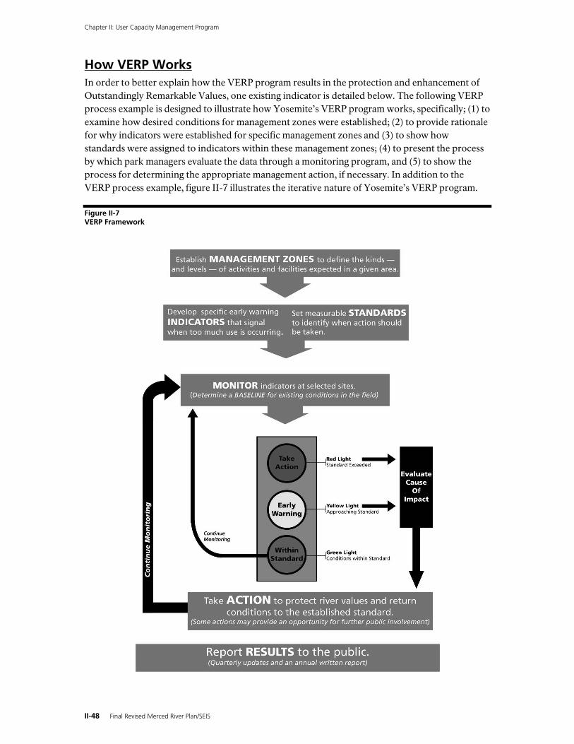
Chapter II: User Capacity Management Program
II-48 Final Revised Merced River Plan/SEIS
How VERP Works In order to better explain how the VERP program results in the protection and enhancement of Outstandingly Remarkable Values, one existing indicator is detailed below. The following VERP process example is designed to illustrate how Yosemite’s VERP program works, specifically; (1) to examine how desired conditions for management zones were established; (2) to provide rationale for why indicators were established for specific management zones and (3) to show how standards were assigned to indicators within these management zones; (4) to present the process by which park managers evaluate the data through a monitoring program, and (5) to show the process for determining the appropriate management action, if necessary. In addition to the VERP process example, figure II-7 illustrates the iterative nature of Yosemite’s VERP program.
Figure II-7 VERP Framework
Chapter II: User Capacity Management Program
Final Revised Merced River Plan/SEIS II-49
VERP Process Example: Length of Social Trails in Meadows (Zones 2B and 2C)
1) Desired Conditions are Established (Management Zoning) Approved management zoning adopted in Merced River Plan was developed to protect and enhance the Outstandingly Remarkable Values within each segment of the river and prescribes certain uses and facilities that are not allowed in an area. Management zoning is a technique used by the National Park Service to classify park areas and prescribe future desired resource conditions, visitor activities, and facilities. Management zoning is defined as “A geographical area for which management directions or prescriptions have been developed to determine what can and cannot occur in terms of resource management, visitor use, access, facilities or development, and park operations. Each zone has a unique combination of resource and social conditions, and a consistent management prescription” (NPS 1997a).
A brief description of the Discovery (2B) and Day Use (2C ) zones are provided below, however a more comprehensive discussion of these management zones are provided in the Merced River Plan. The example indicator discussed in this VERP process example will be monitored in the Discovery (2B) and/or Day Use (2C) zones. Management zones form the basis for selection and application of standards to indicators monitored within these zones.
The Discovery (2B) zone is characterized by relatively quiet natural areas where visitor encounters are low to moderate, however, during high-use periods, some concentrated use and more frequent visitor encounters can occur on trails that link destination points through the Discovery zone. This zone is managed for low tolerance of resource degradation caused by visitor use and emphasizes low-intensity visitor uses. Limits on use and facilities allow natural areas to remain relatively unimpaired when they are not close to one of the few access roads. Areas in the Discovery zone can be used by individuals or smaller organized groups, with access to these areas requiring a moderate level of physical exertion, although some locations would be served by an access road and parking turnouts. Facilities such as roads, improved trails, small turnouts, fencing of sensitive areas, bridges, utilities, and minimal restroom facilities are allowed in this zone. Areas in this zone include Stoneman, Ahwahnee, Cook’s, and Sentinel Meadows.
The Day Use (2C) zone is intended to be applied to popular park destinations, where visitors could spend significant periods of time enjoying the park resources in a relatively accessible setting. Visitors can expect moderate to high numbers of encounters with other park users and crowding on certain peak days. The Day Use zone enhances opportunities for visitors to enjoy more intensive recreational activities near the Merced River, such as swimming, picnicking, and rafting. This zone is managed with moderate tolerance for resource degradation from visitor use in specified areas. Large groups can use these areas and may accesses them by automobile, shuttle bus, and bicycle, with interpretive trails or other marked trails leading to waterfalls, beaches, and scenic views. Facilities such as roads, parking areas, turnouts, shuttle bus stops, non-motorized watercraft launch and removal facilities, bridges, utilities, restrooms, fencing of sensitive areas, picnic tables, and recycling and trash receptacles are allowed in this zone. Areas in this zone include Leidig, El Capitan, and Bridalveil Meadows.
2) A Specific Indicator is Established The length of social trails is indicative of the contiguity and ecological health of meadows and wetland areas; impacts to wildlife habitat, including special-status species; impacts to archeological sites and traditional gathering areas used by American Indian groups; and impacts to visitor experience—including nature study and photography (all recreation Outstandingly
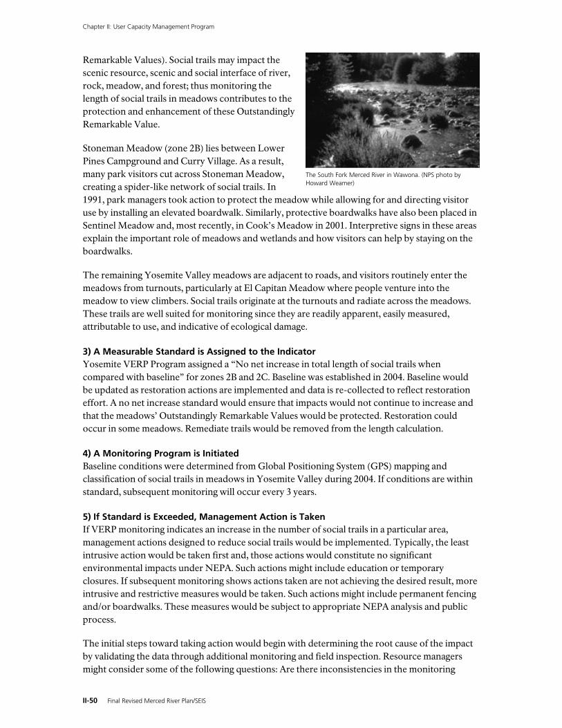
Chapter II: User Capacity Management Program
II-50 Final Revised Merced River Plan/SEIS
Remarkable Values). Social trails may impact the scenic resource, scenic and social interface of river, rock, meadow, and forest; thus monitoring the length of social trails in meadows contributes to the protection and enhancement of these Outstandingly Remarkable Value.
Stoneman Meadow (zone 2B) lies between Lower Pines Campground and Curry Village. As a result, many park visitors cut across Stoneman Meadow, creating a spider-like network of social trails. In 1991, park managers took action to protect the meadow while allowing for and directing visitor use by installing an elevated boardwalk. Similarly, protective boardwalks have also been placed in Sentinel Meadow and, most recently, in Cook’s Meadow in 2001. Interpretive signs in these areas explain the important role of meadows and wetlands and how visitors can help by staying on the boardwalks.
The remaining Yosemite Valley meadows are adjacent to roads, and visitors routinely enter the meadows from turnouts, particularly at El Capitan Meadow where people venture into the meadow to view climbers. Social trails originate at the turnouts and radiate across the meadows. These trails are well suited for monitoring since they are readily apparent, easily measured, attributable to use, and indicative of ecological damage.
3) A Measurable Standard is Assigned to the Indicator Yosemite VERP Program assigned a “No net increase in total length of social trails when compared with baseline” for zones 2B and 2C. Baseline was established in 2004. Baseline would be updated as restoration actions are implemented and data is re-collected to reflect restoration effort. A no net increase standard would ensure that impacts would not continue to increase and that the meadows’ Outstandingly Remarkable Values would be protected. Restoration could occur in some meadows. Remediate trails would be removed from the length calculation.
4) A Monitoring Program is Initiated Baseline conditions were determined from Global Positioning System (GPS) mapping and classification of social trails in meadows in Yosemite Valley during 2004. If conditions are within standard, subsequent monitoring will occur every 3 years.
5) If Standard is Exceeded, Management Action is Taken If VERP monitoring indicates an increase in the number of social trails in a particular area, management actions designed to reduce social trails would be implemented. Typically, the least intrusive action would be taken first and, those actions would constitute no significant environmental impacts under NEPA. Such actions might include education or temporary closures. If subsequent monitoring shows actions taken are not achieving the desired result, more intrusive and restrictive measures would be taken. Such actions might include permanent fencing and/or boardwalks. These measures would be subject to appropriate NEPA analysis and public process.
The initial steps toward taking action would begin with determining the root cause of the impact by validating the data through additional monitoring and field inspection. Resource managers might consider some of the following questions: Are there inconsistencies in the monitoring
The South Fork Merced River in Wawona. (NPS photo by Howard Weamer)
Chapter II: User Capacity Management Program
Final Revised Merced River Plan/SEIS II-51
methodology? Is the impact caused by visitors accessing an area or is it caused by wildlife? Is there inappropriate parking or visitor access in areas adjacent to the meadow? Any information gained from this validation process would be used to further refine VERP monitoring protocols for this indicator.
Depending on the cause identified, park managers would take appropriate management actions to return conditions to, or below, its established standard. If the impact is determined to be caused by wildlife or some other natural event, flattened vegetation will generally recover completely within one year. If the problem is determined to be caused by excessive visitor use, park mangers could implement a range of management actions depending on the magnitude or severity of the problem. The problem may be adequately addressed through additional educational messages (i.e., explaining to visitors the importance of meadows and the sensitive nature of wetlands and impacts related to trampling), installation of signs or additional interpretative exhibits. If the problem is, or has the potential to become severe, management actions may require the construction of barriers to redirect or prevent visitors from entering the affected area, removing adjacent parking, or possibly constructing or formalizing trails to concentrate or redirect use, as appropriate. However, it should be noted that the steps toward taking effective action do not follow a linear progression, and multiple solutions could be implemented simultaneously to help return an area to its desired condition.
The appropriate level of environmental review and public involvement would occur prior to implementing any of the above management actions. If the management action did not require the preparation of an environmental assessment or environmental impact statement, the action would be implemented proactively. If additional environmental compliance were required, implementation would start as soon as practical after the appropriate decision document was finalized. Subsequent monitoring of the affected areas would be conducted to confirm the overall effectiveness of the management actions taken, and ensure that conditions return, to its established standard.
6) Progress is Shared with the Public One important aspect of the VERP program is to engage the public in this ongoing process. Regular communication with the public will highlight the status and results of monitoring activities, management actions taken or considered, and ways to participate in the process. The National Park Service will also present quarterly VERP updates to the public. The VERP monitoring manual is available to the public on the park’s web site. At the end of each year, an annual report that includes analysis of the previous year’s VERP data sampling would be posted on the park’s web site.
Chapter II: User Capacity Management Program
II-52 Final Revised Merced River Plan/SEIS
THIS PAGE INTENTIONALLY LEFT BLANK


![Technical Note No.31 CAPACITY SELECTION II [CALCULATION ... · PDF fileinverter technical note no. 31 capacity selection ii [calculation procedure] (continuous operation) (cyclic operation)](https://static.fdocuments.us/doc/165x107/5a7953c27f8b9aee3b8cec01/technical-note-no31-capacity-selection-ii-calculation-technical-note-no-31.jpg)