CHAPTER II GEOLOGY AND HYDROGELOGY OF THE STUDY...
18
CHAPTER II GEOLOGY AND HYDROGELOGY OF THE STUDY AREA 2.1 Introduction The southern granulite terrain is a mosaic of crustal blocks consisting of Charnockite highland massifs separated from each other by low-land shear zones extending in different directions viz. NE-SW, E-W and NW-SE. The tectonic frame work of south India shield region (SISR) has been studied by various Geological and Geophysical methods and reviewed by various workers (Drury and Holt, 1980; Drury et.al 1984; Radhakrishnen, and John mothai 2004; Chetty, 1996; Ramakrishna, 2003). These studies have identified major shear zones within SISR namely Palghat cavery shear zone (PCSZ) Mayar- Bhavani Shear Zone(MBSZ). Mettur Shear Zone (MTSZ) and Achankovil Shear Zone(ACSZ) as shown in Figure (2.1) and Figure (2.1a). In this, the very important shear zone is Achankoil shear zone. It consists of garnet-biotite-graphite gneisses and garnetiferous charnockite and khondalites (garnet- sillimanite-biotite-graphite), cordierite gneiss. It occurs to the south of the Palghat- Cauvery tectonic zone (Drury and Holt, 1980; Drury et.al., 1984). On the west of this zone, charnokites form the massifs of the Western Ghats and the Eastern part is predominantly of gneisses. This southern predominance of meta-sedimentry rocks such as quartzites, sillimanite quartzites, calc-granulites, garnet and cordierite bearing meta- pelites. In the Northern part of this region, calc-silicates and crystalline limestone occur as thick sequences for a few tens of meters thickness. The study area is divided into two parts one of them is delination of the ground water in hard rock area near Abisekapatti,near Tirunelveli and the other part is to characterize
Transcript of CHAPTER II GEOLOGY AND HYDROGELOGY OF THE STUDY...

CHAPTER II
GEOLOGY AND HYDROGELOGY OF THE STUDY AREA
2.1 Introduction
The southern granulite terrain is a mosaic of crustal blocks consisting of
Charnockite highland massifs separated from each other by low-land shear zones
extending in different directions viz. NE-SW, E-W and NW-SE. The tectonic frame
work of south India shield region (SISR) has been studied by various Geological and
Geophysical methods and reviewed by various workers (Drury and Holt, 1980; Drury
et.al 1984; Radhakrishnen, and John mothai 2004; Chetty, 1996; Ramakrishna, 2003).
These studies have identified major shear zones within SISR namely Palghat cavery shear
zone (PCSZ) Mayar- Bhavani Shear Zone(MBSZ). Mettur Shear Zone (MTSZ) and
Achankovil Shear Zone(ACSZ) as shown in Figure (2.1) and Figure (2.1a).
In this, the very important shear zone is Achankoil shear zone. It consists of
garnet-biotite-graphite gneisses and garnetiferous charnockite and khondalites (garnet-
sillimanite-biotite-graphite), cordierite gneiss. It occurs to the south of the Palghat-
Cauvery tectonic zone (Drury and Holt, 1980; Drury et.al., 1984). On the west of this
zone, charnokites form the massifs of the Western Ghats and the Eastern part is
predominantly of gneisses. This southern predominance of meta-sedimentry rocks such as
quartzites, sillimanite quartzites, calc-granulites, garnet and cordierite bearing meta-
pelites. In the Northern part of this region, calc-silicates and crystalline limestone occur
as thick sequences for a few tens of meters thickness.
The study area is divided into two parts one of them is delination of the ground water
in hard rock area near Abisekapatti,near Tirunelveli and the other part is to characterize
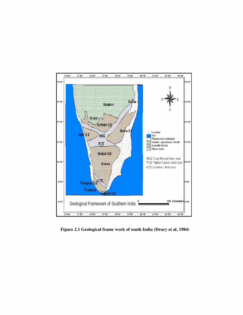
Figure 2.1 Geological frame work of south India (Drury et al, 1984)
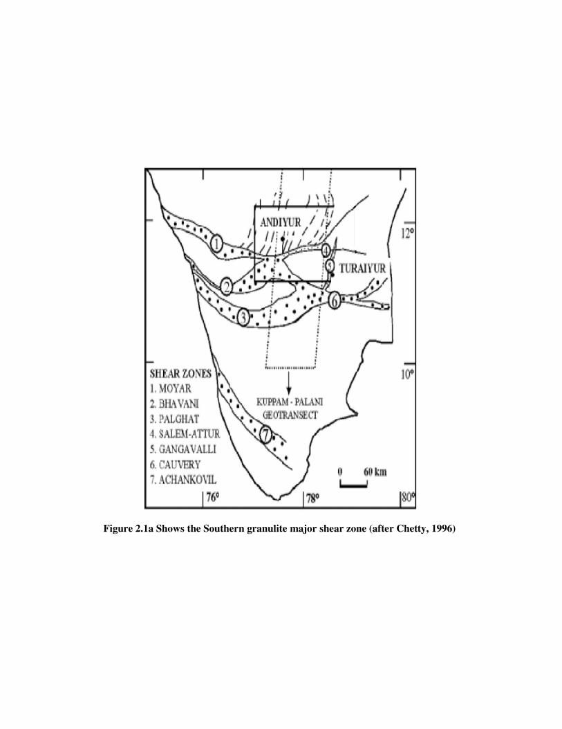
Figure 2.1a Shows the Southern granulite major shear zone (after Chetty, 1996)
ground water along the coastal area of Thuthukudi, Tamilnadu. The location, geology and
Hydrogeology are described below
2.2 Location of the study area
a) Abisekapatti
The Tirunelveli District in southern India, is located in the world map, between
08°8’ and 09°23’ latitude and 77°09’ and 77°54’ longitude. Tirunelveli district is
bounded on the north by Virudhunagar district, east by Thuthukudi district, south by Gulf
of Mannar, South west by Kanniyakumari district and west by Kerala state. The total
geographical area of the district is 6823.06 sq.km and is divided into nine taluks namely
Ambasamudram, Nanguneri, Palayamkottai, Radhapuram, Sankarankovil, Shencottai,
Sivagiri, Tenkasi and Tirunelveli.
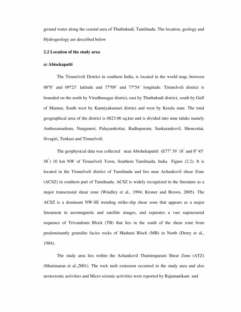
The geophysical data was collected near Abishekapattil (E77o 39
’ 18
” and 8
o 45’
58”) 10 km NW of Tirunelveli Town, Southern Tamilnadu, India Figure (2.2). It is
located in the Tirunelveli district of Tamilnadu and lies near Achankovil shear Zone
(ACSZ) in southern part of Tamilnadu. ACSZ is widely recognized in the literature as a
major transcrustal shear zone (Windley et al., 1994; Kroner and Brown, 2005). The
ACSZ is a dominant NW-SE trending strike-slip shear zone that appears as a major
lineament in aeromagnetic and satellite images, and separates a vast supracrustal
sequence of Trivandrum Block (TB) that lies in the south of the shear zone from
predominantly granulite facies rocks of Madurai Block (MB) in North (Drury et al.,
1984).
The study area lies within the Achankovil Thamiraparani Shear Zone (ATZ)
(Manimaran et al.,2001). The rock melt extrusion occurred in the study area and also
neotectonic activities and Micro seismic activities were reported by Rajamanikam and
Figure 2.2 Location map of the study area (after Manimaran .et.al 2001)
Chandrasekar (2000) along the lineaments bounding the different tectonic units in
Peninsular India. The geological evaluation of the south Indian area is more complex and
hence requires better understanding of the present study area. Taking in to account of
these incidences, geoelectrical studies were carried out. While geological studies can
provide information on the surface manifestation of the shear zones, only geoelectrical
investigations can provide significant depth information, especially regarding the nature
and extension of geological contacts, fault zones at different depths.
b) Thuthukudi
The study area Thuthukudi (780
7’30’’E and 8048’45’’N), lies in the east coastal
belt Tamil Nadu (Figure 2.3) in India, Southern India Topographic elevation varies from
27 m (amsl) to a few meters (amsl) near Thuthukudi town and slopes from west to east.
The slope is gentle in the western and the central part and nearly flat in the eastern part.
The land is utilized for cultivation of cotton, maize and some medicinal plants.
Some of the land is fallow and some is barren with vegetation such as thorny shrubs with
thin cover of dry grass and palms. The area receives rainfall during the northeast
Monsoon season, which is active during the months of October, November, and
December. The long-term average annual rainfall of Thuthukudi town is 568 mm (IMD
data). The study area has large number of open wells and bore wells they are being used
for domestic and irrigation purposes.
2.3 Geological formation of the study area
Tirunelveli district of Tamilnadu is the southern part of the Indian Precambrian
Shield comprising a wide variety of geological formations ranging from Precambrian to
recent period. Major portion of the district is covered by plain topography. North West
and western portion of the district are gently sloping to undulating. Parts of

Figure 2.3 Location map of the study area
Ambasamudram, Tenkasi, Shencottai and Sivagiri taluks are covered by high hills in the
west. These hills form part of the western ghats. There are number of waterfalls in the hill
ranges. The plain area of the district can be divided into two elevating stages viz below
150 and 150-300m. The Tamirabarani is the major drainage system covers the central part
of the district.
Different types of Charnockitic rocks and metasedimentary gneissic formations
are distributed throughout the Tirunelveli district. They can be classified into granitoid,
non-garnetiferous mica, hornblende gneisses and mixed gneisses associated with
migmatities. Migmatitic assemblage of garnetiferous biotite gneisses (Khondalitic),
garnetiferous quartzo- felspathic granulites(leptynitic). The charnockitic rocks of the
Tirunelveli and non-garnetiferous quartzo-felspathic granulites (alskitic) district are
conformable in strike and in south and south west part of the district. The central part of
the district is reported with predominant zone of quartzite beds and associated crystalline
limestone and calc gneisses with intercalated layers and bands of pyroxene granulites
within the quartzite beds (Narayanaswamy and Lakshmi, 1967).The major
lithostratigraphic units in the study area include garnet bearing charnockites, garnet and
sillimanite rich metapelitic (khondalitic) and garnetbiotite-quartz-feldspar gneisses
underlain by black cotton soil (Barun et al, 1998; Shabeer et al, 2005).
The geological structure consists of an earlier period of folding about a NW-SE
axis, followed by a second stage cross-folding about a NNW-SSE axis, and discordance
of rock types as well as structural elements in the north-east part of the district by a zone
of thrust. The charnockitic rocks thus appear to have been subjected to two periods of
deformation, granitic intrusion and metamorphic episodes.
Limestone is available at several places in the district. The major part comes from
the crystalline limestone deposit occurring near Ramayanpatti, Thalaiyuthu, and
Padmaneri. A total reserve of 4.06 million tones limestone up to depth of 15.2 meter in

Ramayanpatti band and 5.08 million tonnes up to a depth of 15.25 meter in Thalaiyuthu
has been estimated.
The limestones available here contain Calcium Oxide (CaO) from 34.97 to 55.49
percent, Magnesium Oxide (MgO) from 0.31 to 7.24 percent. The Padmaneri band
consists of six limestone lenses with an aggregate strike length of about 800 meter. The
average width is 4.75 meter 0.199 million tonnes of cement grade limestone is estimated
from this band. The Singikulam band extends over a strike length of 17 km. It contains
seven limestone lenses with an aggregate strike length of about 6.4 km. and average width
of 13 meter. About 3.160 million tons of cement grade limestone is estimated from this
band.Six bands of good quality limestone occur near Pandapuli and 4, 34,000 tones of
limestone suitable for the manufacture of cement and chemical industries have been
estimated. Light traces of sulphides occur in and around Pattankadu and Munradaippu.
This mineral is of no economic importance by National Informatic Centre, Tirunelveli.
Occurrence of red garnet sands in the beds of the river Nambiar and Ovari has
been recorded. The proportion of garnet is 75% in the rich deposits and 45% in the
surface sands. Local concentration of Ilmenite sands are noticed near Vijayapatti and
Kuttankuli.
The rock types met within the district can be broadly classified into three groups
as detailed below.
1. Charnokite group of rocks of Archean period with Hypersthene mainly in
Sankarankovil, Sivagiri and Tenkasi taluks.
2. Gneissic group of rocks of Archean period consisting of
a) Granitoid mica gneiss
b) Granitic mica gneiss and Leptinites
c) Mixed and composite gneiss
3. Shell lime stone, tuffaceous kankar, tertiary kankar, coastal and their lands of
quartenery period, recent to Holocene age.
The dominant minerals are Limestone, Gypsum,Garnet sand, Ilmenite and Blue
metal. The main country rocks of the district are : (1) grantioid non-garnetiferous mica
and hornblende gneisses and mixed gneisses associated with migmatites in northeast
Tinnevelly, and (2) a migmatitic assemblage of garnetiferous biotite gneisses
(khondalitic), garnetiferous quartzo-felspathic granulites (alaskitic) in south and south-
west Tirunelveli. There is a predominanca of quartzite beds and associated crystalline
lime stones and calc-silicate rocks, together with intercalated layers and bands of
pyroxene granulites within the quartzite beds in the central parts of the district. Pyroxene
granulites, invariably containing hypersthene occur as narrow bands and lenses following
the foliation of the garnetiferous gneisses; they also occur as alternating parallel bands
and layers in the quartzites and the intermediate gneissis charnockitic rocks. The main
zone of charnockitic rocks is found in the north-west part of the district in Sankarankovil-
Tenkasi plains and adjacent Western Ghat ranges. Runs of gneissic as well as acid
micropertitic charnockites occur parallel to the regional strike. The charnockitic rocks are
generallyassociated with garnetiferous gneisses and are almost completely absent in the
predominantly granitoid gneissic terrain in the north-east and eastern parts of the district.
The regional strike of foliation and banding, which is conformable in all rock
types throughout the district, is generally NE-SW in the west and south-west Tirunelveli,
veering to WNW-SSE to EW in the south-eastern parts of the district. The strike abruptly
changes to NNW-SSE or NS about a NW-SE line passing through Srivaikuntam,
Thalaiyuthu and Sankarankovil.
The charnockitic rocks throughout the district reveal foliation and banding
conformable in strike and dip with the enclosing gneissic country rocks and associated
meta-sedimentary and meta-volcanic/hypabyssal rocks. A study of the structural and
tectonic history of the district reveals that there is an earlier period of folding, about a
NW-SE axial trend, the folds plunging probably to the SE as indicated by closures of
certain rock formations. A second stage of folding, either later or immediately
succeeding the above, appears to have refolded the earlier folds about a NNW-SSE axis.
One such major cross-fold is the main structural element exposed in the Tirunelveli
district.
The charnockitic suite of Tirunelveli has undergone two periods of deformation
with accompanying metamorphism and granitic intrusions. Nowhere in the district are
seen granitic or other intrusives cutting across the strikes of foliation and banding; even
the later pegmatites and vein-quartz conform to the foliation strikes. It would, therefore,
appear that the khondalite-charnockite suite and associate gneisses and migmatites of
Tirunelveli belong to a deep-seated hypo-metamorphic, syntectonic (palingenetic)
migmatite complex.
The area under investigation of Thuthukudi in the Gulf of Mannar presents great
interest because it is an industrial belt consisting of many major industries involved in the
production of chemicals, petrochemicals and plastics. In addition, a major harbor, thermal
power plant, heavy water plant and human activities from around Thuthukudi have
altered the ecosystem prominently
The area investigated forms the southern part of the South Indian Granulite facies
terrain, which includes part of Madurai Block (MB) and the Kerala Khondalite Belt
(KKB). The southern part of MB is represented by charnockites in the western part and
gneisses in the eastern part which are inter-banded with supracrustals chiefly of meta-

sedimentary sequences mainly made up of quartzite, carbonate and metapelite with a
minor metabolic component. KKB is bounded by the Cardamon Hills in the north and the
Nagerkoil Charnockite Massif in the south, which consists of high-grade supracrustals.
The MB and KKB, which are separated by the Achankoil Shear Zone (AKSZ), are mostly
similar in geochronologic characteristics (Santosh et al, 2003; Harris et al,
1994).Gneisses, charnockites, and quartzites of Archaean age, calcareous sandstone and
shell limestone of tertiary age, and alluvium of recent age underlie the area. The Archaean
groups of formations are crystalline and metamorphic, and finely foliated with a general
NW–SE trend described by Balasubramanaian et al, (1993). The formations, including
quartzites as ridges in the western part, are weathered, jointed, and fractured. recent to
sub-recent sand occupies coastal areas. It consists of coarse and calcareous grits
sandstone and shell limestone. The area is covered with black soils in the western part,
red soil (sandyloam to sandy soil) in the central part and alluvial sandy soils in the eastern
part. The maximum soil thickness is about 3 m. The sandy soils originated from
sandstones and these have low soil moisture retentivity. The alluvium soils are wind-
blown sands and shells constitute beach sand and coastal dunes, which have very low soil
moisture retentivity.
This area is underlain by Archaean complex of rocks that occupy western part of
the study area. It includes ridges of quartzites, bands of charnockites and peninsular
gneisses which are weathered, jointed and fractured at places. The tertiary formation
overlies the Archaean complex with marked unconformity, consists of calcareous
sandstone and shale limestone. These are medium-to-fine grained, compact and
fossiliferous in nature. The thickness of the formation varies from few to few tens of
meters. Recent to sub-recent sand occupies most of the coastal areas. It consists of coarse
and calcareous grits, sandstone, shale limestone. Accumulation of windblown sands and
shale’s constitute beach Sand and coastal dunes.
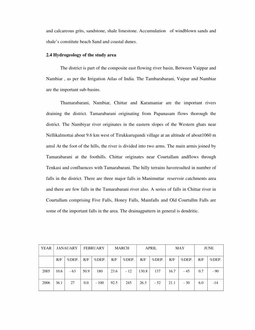
2.4 Hydrogeology of the study area
The district is part of the composite east flowing river basin, Between Vaippar and
Nambiar , as per the Irrigation Atlas of India. The Tambarabarani, Vaipar and Nambiar
are the important sub-basins.
Thamarabarani, Nambiar, Chittar and Karamaniar are the important rivers
draining the district. Tamarabarani originating from Papanasam flows thorough the
district. The Nambiyar river originates in the eastern slopes of the Western ghats near
Nellikalmottai about 9.6 km west of Tirukkurugundi village at an altitude of about1060 m
amsl At the foot of the hills, the river is divided into two arms. The main armis joined by
Tamarabarani at the foothills. Chittar originates near Courtallam andflows through
Tenkasi and confluences with Tamarabarani. The hilly terrains haveresulted in number of
falls in the district. There are three major falls in Manimuttar reservoir catchments area
and there are few falls in the Tamarabarani river also. A series of falls in Chittar river in
Courtallam comprising Five Falls, Honey Falls, Mainfalls and Old Courtallm Falls are
some of the important falls in the area. The drainagpattern in general is dendritic.
YEAR JANAUARY FEBRUARY MARCH APRIL MAY JUNE
R/F %DEP. R/F %DEP. R/F %DEP. R/F %DEP. R/F %DEP. R/F %DEP.
2005 10.6 - 63 50.9 180 23.6 - 12 130.8 137 16.7 - 45 0.7 - 90
2006 36.1 27 0.0 - 100 92.5 245 26.3 - 52 21.1 - 30 6.0 -14

2007 32.2 13 8.0 - 56 0.6 - 98 56.8 3 7.0 - 77 11.4 63
2008 3.8 - 87 91.1 401 264.6 887 58.9 7 0.4 - 99 3.3 -53
2009 6.8 - 76 0.2 -99 16.8 -37 79.5 44 17.0 - 44 1.2 -83
YEAR JULY AUGUST SEPTEMBER OCTOBER NOVEMBER DECEMBER
R/F %DEP. R/F %DEP. R/F %DEP. R/F %DEP. R/F %DEP. R/F %DEP.
2005 19.6 19 14.9 - 34 13.2 - 68 99.3 - 34 235.0 35 119.3 42
2006 0.4 - 98 7.7 - 66 47.8 17 309.8 104 337.2 93 24.7 - 71
2007 30.9 87 37.9 68 21.5 - 47 196.2 29 111.9 - 36 62.3 - 26
2008 9.0 -45 49.9 122 3.5 - 91 357.9 136 180.0 3 54.5 - 35
2009 0.7 - 96 18.7 - 17 33.9 - 17 56.0 - 63 386.6 122 47.9 -43
R/F - Arithmatic average of rainfall % dep. - depatures of rainfall
(by Hydromet division, India meterological department)
Table 2.1 Tirunelveli district rainfall for last five years in mm
Month Normal 1996 1997 1998 1999 2000
January 50.2 22.30 2.39 2.67 6.67 37.47
February 30.2 35.34 0.00 3.00 66.68 143.97
March 41.3 6.40 14.56 0.00 0.80 24.04
April 59.8 98.12 68.98 11.13 26.93 20.65
May 38.0 23.36 72.53 103.35 35.34 16.96
June 29.6 35.00 4.90 23.62 39.69 55.23
July 26.4 31.44 7.51 53.38 8.11 9.39
August 23.3 23.63 10.88 45.07 3.39 95.86
September 30.2 35.11 25.20 4.62 41.71 74.09
October 166.0 230.34 290.67 67.75 193.93 24.78
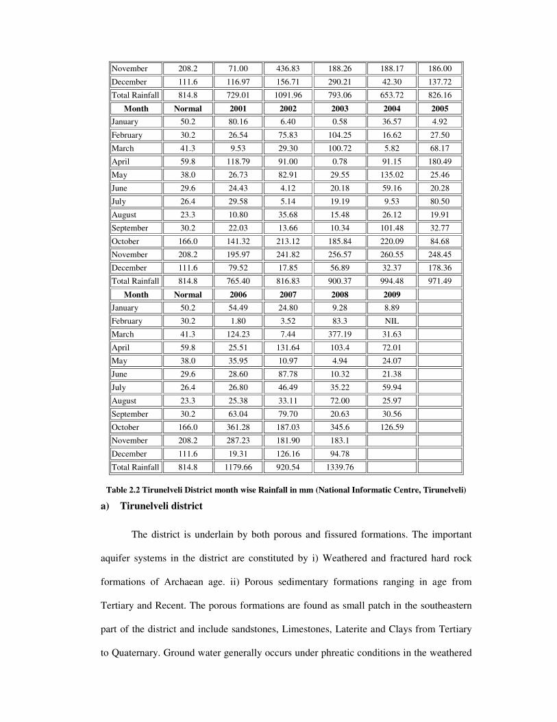
November 208.2 71.00 436.83 188.26 188.17 186.00
December 111.6 116.97 156.71 290.21 42.30 137.72
Total Rainfall 814.8 729.01 1091.96 793.06 653.72 826.16
Month Normal 2001 2002 2003 2004 2005
January 50.2 80.16 6.40 0.58 36.57 4.92
February 30.2 26.54 75.83 104.25 16.62 27.50
March 41.3 9.53 29.30 100.72 5.82 68.17
April 59.8 118.79 91.00 0.78 91.15 180.49
May 38.0 26.73 82.91 29.55 135.02 25.46
June 29.6 24.43 4.12 20.18 59.16 20.28
July 26.4 29.58 5.14 19.19 9.53 80.50
August 23.3 10.80 35.68 15.48 26.12 19.91
September 30.2 22.03 13.66 10.34 101.48 32.77
October 166.0 141.32 213.12 185.84 220.09 84.68
November 208.2 195.97 241.82 256.57 260.55 248.45
December 111.6 79.52 17.85 56.89 32.37 178.36
Total Rainfall 814.8 765.40 816.83 900.37 994.48 971.49
Month Normal 2006 2007 2008 2009
January 50.2 54.49 24.80 9.28 8.89
February 30.2 1.80 3.52 83.3 NIL
March 41.3 124.23 7.44 377.19 31.63
April 59.8 25.51 131.64 103.4 72.01
May 38.0 35.95 10.97 4.94 24.07
June 29.6 28.60 87.78 10.32 21.38
July 26.4 26.80 46.49 35.22 59.94
August 23.3 25.38 33.11 72.00 25.97
September 30.2 63.04 79.70 20.63 30.56
October 166.0 361.28 187.03 345.6 126.59
November 208.2 287.23 181.90 183.1
December 111.6 19.31 126.16 94.78
Total Rainfall 814.8 1179.66 920.54 1339.76
Table 2.2 Tirunelveli District month wise Rainfall in mm (National Informatic Centre, Tirunelveli)
a) Tirunelveli district
The district is underlain by both porous and fissured formations. The important
aquifer systems in the district are constituted by i) Weathered and fractured hard rock
formations of Archaean age. ii) Porous sedimentary formations ranging in age from
Tertiary and Recent. The porous formations are found as small patch in the southeastern
part of the district and include sandstones, Limestones, Laterite and Clays from Tertiary
to Quaternary. Ground water generally occurs under phreatic conditions in the weathered

mantle and under semi-confined conditions in the fissured and fractured zones at deeper
levels. The thickness of weathered zone in the district is in the ranges up to 30m bgl. The
yield characteristics of wells vary considerably depending on the topographic set-up,
lithology and nature of weathering. to 13.65 m bgl during pre-monsoon and
0.47 m bgl to 13.25 m bgl during post-monsoon. Table 2.1 and Table 2.2 shows the
Tirunelveli District rainfall for the past few years.
b) Thuthukudi district
The Thuthukudi district is part of the composite east flowing river basin,
“Between Gundar and Nambiyar” as per the Irrigation Atlas of India. Nambiyar,
Tambraparani, Kallar,Vaippar and Gundar are the important sub basins. The river
originating from the Western Ghats and Tamil Nadu uplands control the drainage network
of the district. A few streams originate in the hillocks within the district and confluence
directly with the sea after flowing 10 km to 20 km. Vaipar, Tambraparani and
Karamanaiyar are the major rivers draining the district. All the rivers are ephemeral in
nature and the run off is generated in heavy rainfall period only. Isolated occurrence of
calcareous sandstone and fossiliferous limestone are seen in coastal area on the south as
tern side. The shallow aquifer is developed through dug wells and deeper aquifer through
YEAR JANAUARY FEBRUARY MARCH APRIL MAY JUNE
R/F %DEP. R/F %DEP. R/F %DEP. R/F %DEP. R/F %DEP. R/F %DEP.
2005 8.2 - 80 23.6 - 24 68.5 64 204.7 232 22.3 - 42 18.0 - 13
2006 69.2 67 3.2 - 90 120.7 189 28.6 - 54 34.9 - 10 26.4 28
2007 19.8 - 52 0.1 -100 7.5 - 82 119.7 94 9.1 - 76 94.2 357
2008 9.4 -77 53.2 71 400.5 860 106.4 73 2.9 - 92 11.0 - 47
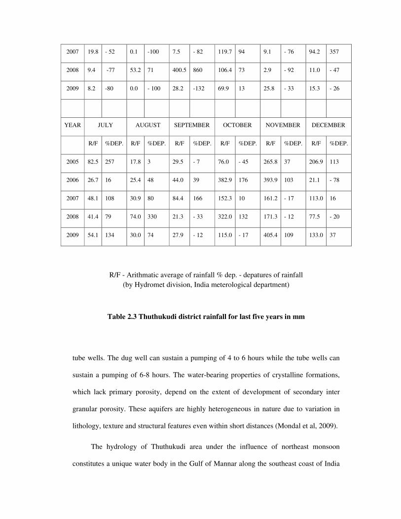
2009 8.2 -80 0.0 - 100 28.2 -132 69.9 13 25.8 - 33 15.3 - 26
YEAR JULY AUGUST SEPTEMBER OCTOBER NOVEMBER DECEMBER
R/F %DEP. R/F %DEP. R/F %DEP. R/F %DEP. R/F %DEP. R/F %DEP.
2005 82.5 257 17.8 3 29.5 - 7 76.0 - 45 265.8 37 206.9 113
2006 26.7 16 25.4 48 44.0 39 382.9 176 393.9 103 21.1 - 78
2007 48.1 108 30.9 80 84.4 166 152.3 10 161.2 - 17 113.0 16
2008 41.4 79 74.0 330 21.3 - 33 322.0 132 171.3 - 12 77.5 - 20
2009 54.1 134 30.0 74 27.9 - 12 115.0 - 17 405.4 109 133.0 37
R/F - Arithmatic average of rainfall % dep. - depatures of rainfall
(by Hydromet division, India meterological department)
Table 2.3 Thuthukudi district rainfall for last five years in mm
tube wells. The dug well can sustain a pumping of 4 to 6 hours while the tube wells can
sustain a pumping of 6-8 hours. The water-bearing properties of crystalline formations,
which lack primary porosity, depend on the extent of development of secondary inter
granular porosity. These aquifers are highly heterogeneous in nature due to variation in
lithology, texture and structural features even within short distances (Mondal et al, 2009).
The hydrology of Thuthukudi area under the influence of northeast monsoon
constitutes a unique water body in the Gulf of Mannar along the southeast coast of India
and is being rapidly affected by industrialization during the past few years. Table 2.3
show the Thuthukudi District rainfall for the past few years. The district is underlain by
both porous and fissured formations. The important aquifer systems in the district are
constituted by i) unconsolidated and semi consolidated formations and ii) weathered and
fractured crystalline rocks. The porous formations in the district include sandstones and
clays of recent to sub-recent and Tertiary age (Quaternary). The recent formations
comprising mainly sands, clays and gravels are confined to major drainage courses in the
district. The maximum thickness of alluvium is 45.0 m bgl, whereas the average thickness
is about 25.0 m. The water-bearing properties of crystalline formations which lack
primary porosity depend on the extent of development of secondary intergranular
porosity. The occurrence and movement of ground water in these rocks are under
unconfined conditions in the joints, fissures and dependent on the nature and extent of
pores and interconnection of fracture zones.