Chapter I introduction - Karnataka · Chapter I introduction ... home to some of the most powerful...
48
Chapter I INTRODUCTION Karnataka has a rich heritage, inspiring its people to create a bright future. With its special geographical location full of variety-its rivers, hills, valleys, plains, forests and resources-the State is known for its tourist and industrial potential. Its long history of over 2,000 years has left many beautiful forts, tanks, temples, mosques and towns of historical importance to the posterity. These old towns have grown to be industrial, commercial and educational centres. They are provided with all modern facilities. Bordered by the Western Ghats with tall peaks and lush greenery in the west, the tableland is fertile because of its black soil and river and tank irrigation facilities. The coastal strip to the west of the Ghats is renowned for its silvery beaches and rich green paddy fields. Karnataka has rich religious and artistic traditions. The land has been described by a poet in a stone record in the 15 th Century in following words: A mine of good discipline, The dwelling place of Brahma, The land which had acquired great fortune, The birthplace of learning and wealth, The true home of unequalled splendid earnestness Thus distinguished in many ways Shone the lovely Karnata Country. The temples of antiquity speak of the piety of their devotees. The agraharas and mathas spread all over vouch to the scholarly pursuits to which people were attached. The hero stones strewing the land speak of the heroic traits of the warrior race of antiquity. Long traditions of growing cotton are clear evidence to once flourishing rich textile industry. The ports along the coast remind one of the rich overseas trades that flourished through them. The black soil plains speak of its agricultural potential. The State’s human resources with racial and religious varieties and professional skills promise to make it a hub of industriousness. With an antiquity that dates to the paleolithic, Karnataka has also been home to some of the most powerful empires of ancient and medieval India. The philosophers and musical bards patronized by these empires launched socio-religious and literary movements which have endured to the present day. Karnataka has contributed significantly to both forms of Indian classical music, the Carnatic (Karnataka Music) and Hindustani traditions. Writers in the Kannada language have received the most number of Jnanapith awards in India. Bangalore is the capital city of the State and is at the forefront of the rapid economic and technological development that India is experiencing.
Transcript of Chapter I introduction - Karnataka · Chapter I introduction ... home to some of the most powerful...

Chapter I
introductionKarnataka has a rich heritage, inspiring its people to create a bright future. With its special geographical location full of variety-its rivers, hills, valleys, plains, forests and resources-the State is known for its tourist and industrial potential. Its long history of over 2,000 years has left many beautiful forts, tanks, temples, mosques and towns of historical importance to the posterity. These old towns have grown to be industrial, commercial and educational centres. They are provided with all modern facilities.
Bordered by the Western Ghats with tall peaks and lush greenery in the west, the tableland is fertile because of its black soil and river and tank irrigation facilities. The coastal strip to the west of the Ghats is renowned for its silvery beaches and rich green paddy fields.
Karnataka has rich religious and artistic traditions. The land has been described by a poet in a stone record in the 15th Century in following words:
A mine of good discipline,The dwelling place of Brahma,
The land which had acquired great fortune,The birthplace of learning and wealth,
The true home of unequalled splendid earnestnessThus distinguished in many waysShone the lovely Karnata Country.
The temples of antiquity speak of the piety of their devotees. The agraharas and mathas spread all over vouch to the scholarly pursuits to which people were attached. The hero stones strewing the land speak of the heroic traits of the warrior race of antiquity. Long traditions of growing cotton are clear evidence to once flourishing rich textile industry. The ports along the coast remind one of the rich overseas trades that flourished through them. The black soil plains speak of its agricultural potential. The State’s human resources with racial and religious varieties and professional skills promise to make it a hub of industriousness.
With an antiquity that dates to the paleolithic, Karnataka has also been home to some of the most powerful empires of ancient and medieval India. The philosophers and musical bards patronized by these empires launched socio-religious and literary movements which have endured to the present day. Karnataka has contributed significantly to both forms of Indian classical music, the Carnatic (Karnataka Music) and Hindustani traditions. Writers in the Kannada language have received the most number of Jnanapith awards in India. Bangalore is the capital city of the State and is at the forefront of the rapid economic and technological development that India is experiencing.

2A Handbook of Karnataka
Location and BoundariesThe State of Karnataka, confined roughly within 11°35’ North and 18°30’
North latitudes and 74°5’ East and 78°35’ East longitudes, is situated on a
The responsibility for the correctness of internal details rests with the publisher.
The territorial waters of India extending into the sea to the distance of twelve nautical miles measured from the appropriate base line.
The state boundaries between Uttara Khand and Uttara Pradesh, Bihar and Jharkhand and Chattisgarh and Madhya Pradesh have not been verified by the
Governments concerned. The administrative Headquarters of Chandigarh. Haryana and Punjab are at Chandigarh.
The interstate Boundaries amongst Arunachal pradesh, Assam and Meghalaya shown on the map are as interpreted from the North Eastern areas (Reorganisation) Act, 1971, but have yet be verified.

Introduction 3
tableland where the Western and Eastern Ghat ranges converge into the Nilgiri hill complex. Karnataka is a state in the southern part of India. It was created on November 1, 1956, with the passing of the States Reorganization Act. Originally known as the State of Mysore, it was renamed Karnataka in 1973. Karnataka is bordered by the Arabian Sea to the west, Goa to the northwest, Maharashtra to the north, Andhra Pradesh to the east, Tamil Nadu to the southeast, and Kerala to the southwest. The state extends to about 750km from North to South and about 400km from East to West.
Area and Population
The state covers an area of 74,122 sq miles (191,791 km²), or 5.83% of the total geographical area of India. It is the eighth largest Indian state by area, the ninth largest by population and comprises 29 districts. Kannada is the official and most widely spoken language. Though several etymologies have been suggested for the name Karnataka, the generally accepted one is that Karnataka is derived from the Kannada words karu and nādu, meaning elevated land. Karu nadu may also be read as Karu (black) and nadu (region), as a reference to the black cotton soil found in the Bayaluseeme region of Karnataka. The British used the word Carnatic (sometimes Karnatak) to describe both sides of peninsular India, south of the Krishna River.
There are 29 districts in Karnataka—Bagalkote, Bengaluru Rural, Bengaluru Urban, Belgaum, Bellary, Bidar, Bijapur, Chamarajanagar, Chikkaballapur, Chikkamagaluru, Chitradurga, Dakshina Kannada, Davanagere, Dharwad, Gadag, Gulbarga, Hassan, Haveri, Kodagu, Kolar, Koppal, Mandya, Mysore, Raichur, Ramanagara, Shimoga, Tumkur, Udupi and Uttara Kannada. Each district is governed by a district commissioner or district magistrate. The districts are further divided into sub-divisions, which are governed by sub-divisional magistrates; sub-divisions comprise taluks containing panchayats (village councils) and town municipalities. As per the 2001 census, Karnataka’s six largest cities sorted in order of decreasing population were, Bangalore, Hubli-Dharwad, Mysore, Gulbarga, Belgaum and Mangalore. Bangalore is the only city with a population of more than one million. Bangalore Urban, Belgaum and Gulbarga are the most populous districts, each of them having a population of more than three million. Gadag, Chamarajanagara and Kodagu districts have a population of less than one million.
According to the 2001 census of India, the total population of Karnataka is 52,850,562, of which 26,898,918 (50.89%) are male and 25,951,644 (49.11%) are female, or 1000 males for every 964 females. This represents a 17.25% increase over the population in 1991. The population density is 275.6 per km² and 33.98% of the people live in urban areas. The literacy rate is 66.6% with 76.1% of males and 56.9% of females being literate. 83% of the population are Hindu, 11% are Muslim, 4% are Christian, 0.78% are Jains, 0.73% are Buddhist, and with the remainder belonging to other religions.

4A Handbook of Karnataka
!
!
! P
!
!
P
!
!!
!
!
!
!
P
!
!
P!
!!
!
!
!!
!
!
P!
!P
!
!
!
!!
!
P!
!!
!!
!! !
!P
!
P
P!
!
!
P
!
!
!
!
!
! !
!
!!
!
P
!
!
P !!
! ! !
!
!
!
!
!!! P
!
!
P
!!
!
!
!
!
!
!
P!
!
!
!
!
!
!!! ! !
!
!
!!!
P
!
!
!
!P
PP
!
!
!
!
! !
!
!
P!
!
!
!
P!
P !
!
!! !
!
!
!
!!
!!
P!
!!
!!
!
P!
!!
P
!
!
!
P
!
!
! !
!!
P
!
!
!
^
GO
A
L A K
S H
A D
W E
E P S
E A
ARABIAN SEA
KILOMETRES1008060402020 0
KODAGU
BANGALORE RURAL
T - TUMKUR
BangaloreEast
(Gadag-Betigeri)
(Saundatti-Yellama)
BANGALORE
T
DAKSHINA KANNADA
Yelbarga
Yelandur
UDUPI
Tirumakudal-Narsipur
Somvar-pet
Sirugu-ppa
Shriranga-pattana
Raybag
Ramdurg
NavalgundNargund
Nanjangud
MYSORE
Mudhol Muddebihal
Malavalli(Madikeri)
Krishnara-janagara
Kollegal
Khanapur
Jamkhandi
HungundHukeri
HoleNarsipur
Gokak
Chikodi
CHIKKABALLAPURA
CHAMARAJANAGAR
Bilgi
BIJAPUR
BasavanaBagevadi
BAGALKOT
BangaloreNorth
Badami
Sindgi
Indi
Athni
Afzalpur
Hagari-bomma-nahalli
Narasim-harajapura
Chiknaya-kanhalli
Heggada-devankote
Channa-rayapatna Bangalore
South
Harapanahalli
Krishna-rajpet
Basava-kalyan
Gauri-bidanur
Dod-Ballapur
Molakalmuru
CHITRADURGA
Tirthahalli
Sidla-ghatta
SrinivaspurCHIKMAGALUR
DevanahalliNela-mangala
Naga-mangala RAMA-
NAGARA
Channa-patnaPandava-
puraPiriyapatna
Ranibennur
ChallakereDAVANAGERE
Channa-giri
BhadravatiHosanagara
ChintamaniKorata-gere
TuruvekereBeltangadi Bangarapet
Sak-leshpur
Kanakapura
Chincholi
Devadurga
Lingsugur
Gangawati
Kalghatgi Shirhatti
Hadagalli
ShikarpurHolalkere
Kundapura BagepalliMadhugiri Gudibanda
(Mangalore)
Gundlupet
Homnabad
GULBARGA
Chitapur
Shorapur
ParasgadKushtagi
Sampgaon Sindhnur
Mundargi
Shi-ggaonYellapur
Siddapur
Pavagada
HosdurgaTarikere
ArsikereSringeriMulbagal
MudigereHosa-kote
Arkalgud
Virajpet
Jevargi
Shahpur
RAICHURBELGAUM
(BailHongal)
DHARWAD
BELLARY
Haliyal
Kundgol
Mund-god
Savanur
Kudligi
Jagalur
Hari-har
HonavarHonnali
HiriyurBhatkal SHIMOGA
Kunigal
Bantval
Bhalki
YADGIR
KOPPAL
Hospet
Sandur
(Karwar)HAVERI
HangalAnkola Byadgi
TUMKUR
Karkal Tiptur
HASSANMagadi
AnekalPuttur MaddurMANDYA
Hunsur
Aurad
BIDAR
Aland
Sedam
Manvi
GADAGHubli
UTTARA KANNADA
Sirsi
SorabKumta
Sagar
KadurKoppaGubbi
KOLARBelurMalur
Sulya
Supa
Sira
Alur
Ron
Bijapur
Gulbarga
Bidar
RaichurBagalkot
Belgaum
Dharwad
Koppal Bellary
Haveri
DavanagereChitradurga
Shimoga
Udupi Chikmagalur
Madikeri
Mangalore
Mysore
Karwar
Chamrajanagar
Tumkur
Kolar
Chikkaballapura
Ramanagara
Mandya
Hassan
YadgirM
AH
AR
AS
HT
RA
KE
R
AL
A
T A MI
L
NA
DU
AN
DH
RA
P
RA
DE
SH
Hirekerur
Gadag
STATE............................
DISTRICT.......................
TALUK............................
BOUNDARIES:
STATE............................
DISTRICT.......................
TALUK............................
HEADQUARTERS:
ADMINISTRATIVE DIVISIONS 2011KARNATAKA
State/District headquarters are also taluk headquarters.
Bangalore is the headquarters for Bangalore North,BangaloreSouth & Bangalore East taluks and also for Bangalore andBangalore Rural districts.
P
!
^
Where the district/taluk name differs from its headquarters name,the latter is given within brackets.
Territorial Changes
The erstwhile princely State of Mysore came into existence after the Fourth Anglo-Mysore war in 1799 A.D. and it formed the Nucleus State for the New

Introduction 5
State of Mysore under the States’ Reorganization Act of 1956. The area reported corresponding to the unit was 75,412 sq. km. In 1881 this unit consisted of only seven districts namely Bangalore, Tumkur, Kolar, Kadur, Mysore, Chitradurga and Shimoga. In 1886 Hassan district was carved out as eighth district And in 1939, Mandya district was created as the ninth district In 1953, the Bellary district of Madras State (excluding Adoni, Alur and Rayadurga taluks) was transferred to Mysore State when the State of Andhra Pradesh was formed, resulting in an addition of 9,897 sq. km. to the area of the State.
Political movements for the creation of new, linguistic-based states developed around India in the years after independence. The movement to create a Telugu-speaking state out of the northern portion of Madras State gathered strength in the years after independence, and in 1953, the 16 northern, Telugu-speaking districts of Madras State became the new State of Andhra. In December 1953, Prime Minister Jawaharlal Nehru appointed the States Reorganisation Commission to prepare for the creation of states on linguistic lines. This was headed by Justice Fazal Ali and the commission itself was also known as the Fazal Ali Commission. The efforts of this commission were overseen by Govind Ballabh Pant, who served as Home Minister from December 1954. The commission created a report in 1955 recommending the reorganization of India’s states.
The States Reorganization Act of 1956, which went into effect on November 1st, eliminated the distinction between part A, B, and C states. It also reorganized the state boundaries and created or dissolved states and union territories. On November 1st, 1956, India was divided into states and union territories. The Mysore State was enlarged by the addition of Coorg state and the Kannada speaking districts from southern Bombay state and western Hyderabad state.
The State of Mysore (rechristened as Karnataka with effect from 1.11.1973) with its territorial content as it exists now was formed on 1st November 1956 under the States’ Reorganization Act. It comprised of a) the old Mysore State including Bellary district; b) Bijapur, Dharwad and Uttara Kannada district and Belgaum district excluding Chandgad taluk with an area of 54,347 sq.km; c) Gulbarga (Except Kodangal and Tandur taluks)-16,274 sq.km; Raichur (except Alampur and Gadwal taluks)-14,078 sq.km; and Bidar district (except Ahmedpur, Nilanga and Udgir taluks, Nayalkar Circle of Bidar taluk, Zahirabad taluk except Nirna circle and three villages of Humnabad taluk and Narayankhed taluk) with an area of 5,363 sq.km. from former Hyderabad State; d) Dakshina Kannada (except Kasargod taluk and Amindivi islands) with an area of 8,385 sq.km; and Kollegal taluk of Coimbatore district with an area of 2,786 sq.km. from former Madras State; and e) former part C State of Coorg (Kodagu) district with an area of 4,131 sq. km.
In 1969, Savanur taluk was created and in 1974, Hagaribommananahalli taluk was created by the abolition of the former Mallapuram taluk In Bellary
6A Handbook of Karnataka
district During 1986, Bangalore Rural district was carved out of the former Bangalore district. Bangalore district includes Anekal taluk, Bangalore North taluk (including Jala hobli of the former Devanahalli taluk and Dasanapura hobli of the former Nelamangala taluk), Bangalore South taluk (including Tavarekere hobli of the former Magadi taluk and Bidarahalli hobli of the former Hoskote taluk) and Bangalore Urban Agglomeration areas. The Jurisdiction of Karnataka state extends over portions land-locked within Maharashtra i.e. Dhamne S. Bailur and Kudrimani of Belgaum taluk and Mukhed of Aurad taluk of Bidar district.
In August 1997, seven more districts were newly formed raising the number of districts in the State to 27. Bijapur district was bifurcated into Bijapur and Bagalkot districts. Out of eleven taluks, Jamkhandi, Mudhol, Bilgi, Bagalkot, Badami and Hungund taluks were brought under the new Bagalkot district. The present Bijapur district has Indi, Sindhagi, Bijapur, Basavana Bagewadi and Muddebihal taluks. The new Davanagere district was formed by transferring Davanagere, Harihara and Jagalur taluks from Chitradurga district, Channagiri and Honnali taluks from Shimoga district and Harapanahalli taluk from Bellary district. Dharwad district was divided into three districts viz, Dharwad, Gadag and Haveri. Haveri district included Shiggaon, Savanur, Hanagal, Haveri, Byadgi, Hirekerur and Ranibennur taluks. Gadag district comprises of Nargund, Ron, Gadag, Mundargi and Shirahatti taluks while the remaining five taluks viz Dharwad, Navalgund, Hubli, Kalghatgi and Kundgol constituted Dharwad district.
Raichur district was bifurcated into Raichur and Koppal districts. Gangavathi, Koppal, Kusthagi and Yelburga taluks were brought under the newly formed Koppal district while the remaining five taluks viz Devadurga, Lingsurgur, Manvi, Raichur and Sindhanur taluks constituted new Raichur district. Dakshina Kannada was bifurcated into Dakshina Kannada and Udupi districts. Belthangady, Bantwal, Mangalore, Puttur and Sullya taluks remained in new Dakshina Kannada while Karkala, Kundapur and Udupi taluks were transferred to the newly created Udupi district. Out of the eleven taluks of old Mysore district, Chamarajanagar, Gundlupet, Kollegal and Yelandur taluks were transferred to the newly formed Chamarajanagar district while the remaining seven taluks viz Heggadadevanakote, Hunsur, Krishnarajnagar, Mysore, Nanjangud, Periyapatna and Tirumakudal Narasipur taluks formed part of Mysore district.
During August 2007 Ramanagara district was formed by altering the limits of Bangalore Rural District and Chikkaballapur District was formed by altering the limits of Kolar District vide Government Order No RD 27 Bhudapu (p-3), Bangalore, dated 3rd August 2007 and subsequent amendment dated17th August 2007 with effect form 23-08-2007. Ramanagara, Magadi, Kanakapura and Channapatna taluks of Bangalore Rural district were brought under Ramanagar District. Chikkaballapura, Shidlaghatta, Chintamani, Bagepalli

Introduction 7
Gudibande and Gowribidanuru taluks were transferred from Kolar district to the newly formed Chikkaballapura District,
Administrative Divisions
Karnataka State has been divided into four Revenue divisions, 52 sub-divisions, 29 districts, 176 taluks and 747 hoblies/Revenue Circles for administrative purposes. The district-wise area, population and administrative divisions of Karnataka State are given in Table . The Bangalore Division comprises of Bangalore (Urban), Bangalore Rural, Tumkur, Kolar, Chitradurga, Shimoga and Davanagere districts with headquarters at Bangalore. The Mysore Division consists of the districts of Mysore, Mandya, Hassan Chikmagalur, Dakshina Kannada, Kodagu, Udupi and Chamarajanagar districts with headquarters at Mysore. The Belgaum Division has Belgaum, Bijapur, Dharwad, Gadag, Haveri, Uttara Kannada and Bagalkot districts under its jurisdiction with headquarters at Belgaum; and Gulbarga division with headquarters at Gulbarga covers the districts of Bidar, Gulbarga, Bellary, Raichur and Koppal districts. The State has 27,481 inhabited and 1,925 uninhabited villages, 270 towns and urban agglomerations, 5,628 Grampanchayats and 219 Municipal Corporations. Karnataka has only one city with more than a million population viz, Bangalore. It is one of the six largest urban agglomeration out of 23 metropolises, urban agglomerations and cities in India. It occupied fifth position in 1981. In 1991, among six biggest cities only Delhi has grown at a faster rate than Bangalore. The taluk-wise area in sq km. Population, number of inhabited and uninhabited villages, number of sub-divisions and No. of hoblies is given in Appendix.
Area and Administrative Divisions (Numbers)
Sl.No. Year Area in Sq.Km. Taluks Hoblies
Villages Cities & TownsInhabited Un - Inhabited
1 1961 191757 175 662 26377 NA 2312 1971 191773 175 739 26826 2707 2453 1981 191791 175 745 27024 2362 2814 1991 191791 175 745 27066 2127 2545 2001 191791 176 745 27481 1925 2706 2011 191791 176 747 NA NA NA
Physiography
Physiograpically Karnataka State forms part of two well defined macro regions of Indian Union; the Deccan Plateau and the Coastal plains and Islands. The State has four physiographic regions as follows:
1) Northern Karnataka Plateau: Northern Karnataka Plateau comprises of the districts of Belgaum, Bidar, Bijapur, Bagalkot and Gulbarga. It is largely composed of Deccan Trap. It represents a monotonous treeless extensive plateau landscape with a general elevation of 300 to 600 metres from the

8A Handbook of Karnataka
mean sea level. However the river plains of the Krishna, the Bhima, the Ghataprabha and the Malaprabha with the intervening watersheds, the step like landscapes, lateritic scarpments, residual hills and ridges break the monotony of this extensive plateau. The general slope is towards east and this region is largely covered with rich black cotton soils.
Introduction 9
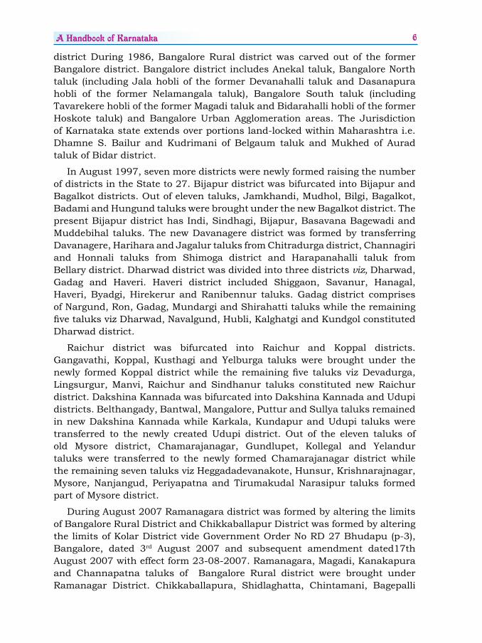
2) Central Karnataka Plateau: Central Karnataka Plateau covers the districts of Bellary, Chikmagalur, Chitradurga, Davanagere, Dharwad, Gadag, Haveri Raichur, Koppal and Shimoga. The region represents the transitional surface between the Northern Karnataka Plateau of Deccan Trap and Southern Karnataka Plateau with relatively higher surface. By and large, this region represents the area of Tungabhadra basin. The general elevation varies between 450 and 700 metres. However, this transitional ground is broken by several sets of parallel ridges mainly made up of Dharwar system of rocks. The height of such residual hills is about 900 metres above mean sea level. The general slope of this region is towards the east.
3) Southern Karnataka Plateau: The Southern Karnataka Plateau covers the districts of Bangalore, Bangalore Rural, Hassan, Kodagu, Kolar, Mandya, Mysore, Chamarajanagar and Tumkur. This region largely covers the area of the Cauvery river basin lying in Karnataka. It is bounded by 600 metres contour and is characterised by a higher degree of slope. In the west and south it is enclosed by the ranges of Western Ghats and the northern part is an interrupted but clearly identifiable high plateau. In the east the valleys of the Cauvery and its tributaries open out to form undulating plains. The general elevation of the region varies from 600 to 900 metres. However residual heights of 1,500 to 1,750 metres are found in the Biligirirangan hills of Mysore district and the Brahmagiri range of Kodagu district
4) Karnataka Coastal Region: The Karnataka Coastal Region, which extends between the Western Ghats edge of the Karnataka Plateau in the east and the Arabian Sea in the west, covers Dakshina Kannada, Udupi and Uttara Kannada districts. This region is traversed by several ridges and spurs of Western Ghats. It has difficult terrain full of rivers, creeks, water falls, peaks and ranges of hills. The coastal region consists of two broad physical units, the plains and the Western Ghats. The Coastal plains, represent a narrow stretch of estuarine and marine plains. The abrupt rise at the eastern flanks forms the Western Ghats. The northern parts of the Ghats are of lower elevation [450-600 metres) as compared to Southern parts (900 to 1,500 metres). The Coastal belt with an average width of 50 to 80 km covers a distance of about 267 km. from north to south. At certain places the crest of adjoining Western Ghats reach the sea as close as 13 km near Karwar. The average height is generally 75 metres from the mean sea level.
TopographyKarnataka has representatives of all types of variations in topography - high
mountains, plateaus, residual hills and coastal plains. The State is enclosed by chains of mountains to its west, east and south. It consists mainly of plateau which has higher elevation of 600 to 900 metres above mean sea level. The entire landscape is undulating broken up by mountains and deep ravines.

10A Handbook of Karnataka
Plain land of elevation less than 300 metres above mean sea level is to be found only in the narrow coastal belt, facing the Arabian Sea. There are quite a few high peaks both in Western and Eastern Ghat systems with altitudes more than 1,500 metres. A series of cross-sections drawn from west to east across the Western Ghat generally exhibit, a narrow coastal plain followed to the east by small and short plateaus at different altitudes, then suddenly rising upto great heights. Then follows the gentle east and east-north-west sloping plateau. Among the tallest peaks of Karnataka are the Mullayyana Giri (1,925 m), Bababudangiri (Chandradrona Parvata 1,894 m) and the Kudremukh (1,895 m) all in Chikmagalur district and the Pushpagiri (1,908 m) in Kodagu district There are a dozen peaks which rise above the height of 1,500 metres. The percentage of area coming under different elevations is as follows: less than 150 metres-5.16; 150 to 300 metres-1.95; 300 to 600 metres-43.51; 600 to 1,350 metres-48.81 and more than 1,350 metres-0.57.
GeoLoGyKarnataka consists of four main types of geological formations; the Archean
complex made up of Dharwad schists and granitic gneisses, the Proterozoic non-fossiliferous sedimentary formations of the Kaladgi and Bhima series, the Deccan trappean and intertrappean deposits and the tertiary and recent laterites and alluvial deposits. Significantly, about 60% of the state is composed of the Archean complex which consist of gneisses, granites and charnockite rocks. Laterite cappings that are found in many districts over the Deccan Traps were formed after the cessation of volcanic activity in the early tertiary period. Eleven groups of soil orders are found in Karnataka, viz. Entisols, Inceptisols, Mollisols, Spodosols, Alfisols, Ultisols, Oxisols, Aridisols, Vertisols, Andisols and Histosols. Depending on the agricultural capability of the soil, the soil types are divided into six types, viz. Red, lateritic, black, alluvio-colluvial, forest and coastal soils.
The geological history of Karnataka is largely confined to the two oldest eras - the Archaean and the Proterozoic. The substantial part of North Karnataka is covered by Deccan Trap. The bulk of the rocks of Karnataka are Archaean in age.
Ancient supracrustals are the oldest rocks dated so far in Karnataka. They are a group of grey gneisses giving an age of 3,400 million years. They are also described as belonging to Sargur schists.
Auriferous Schist Belts (Kolar type) are next in order of age and are a series of basic igneous rocks. They are well developed in the eastern part of the State. Older Gneissic complex consist of an extensive group of grey gneisses (3,400 to 3,000 million years) and act as the basement for an extensive belt of schists. Younger Gneiss complex consist of a group of gneissic rocks mostly of granodioritic and granitic composition. They are found in the eastern parts of the State and range in age from 2,700 to 2,000 million years.
Younger Schist Belts (Dharwar type) are the prominent schistose rocks. They are Archaean in age and belong to the age group of 2,900 to 2,600 million

Introduction 11
years. Two main divisions in this super group are Bababudan and Chitradurga. Ranebennur group is presently classified as the top most formation within Chitradurga group.

12A Handbook of Karnataka
Younger (Closepet) Granites extends in north-south directions as a narrow belt 50 km. Wide. This is a complex of coarse to medium pink and grey granites. Isolated masses of granites like those of Chitradurga, Arasikere, and Banavara belong to the same age group as the younger Granites (2,600 million years). Chornockites are a group of Pyroxene bearing granulites and they are not regarded as separate intrusions and are located in the southern parts of the State.
The close of the Archaean is marked by a period of dyke formation. The majority of the dykes are younger than 2,400 million years. They are of doleritic composition. Besides dolorites, a number of alkaline dyke intrusives have been described in the southern part of Karnataka.
Mineral ResourcesThere are four main types of geological formations in Karnataka according
to Radhakrishnan and Vaidyanadhan. 1) The Archean complex made up of Dharwad schists and granitic gneisses: These cover around 60% of the area of the state and consist of gneisses, granites and charnockite rocks. Some of the minerals found in this region are dolomite, limestone, gabbro, quartzite, pyroxenite, manganese and iron ores and metabasalt. 2) The Proterozoic non-fossiliferous sedimentary formations of the Kaladgi and Bhima series: The Kaladgi series has horizontal rocks that run for 160 km in the districts of Belgaum, Raichur, Dharwad and Bijapur districts. The Bhima series that is present on either side of the Bhima River consists of rocks containing sandstone, limestone and shale and this is present in the Gulbarga and Bijapur districts. 3) The Deccan trappean and intertrappean deposits: This is a part of the Deccan traps which were formed by the accumulation of basaltic lava. This is made up of greyish to black augite-basalt and 4) The tertiary and recent laterites and alluvial deposits: Laterite capping are found over the Deccan Traps and were formed after the cessation of volcanic activity in the early tertiary period. These are found in many districts in the Deccan plateau and also in the coast.
Karnataka is endowed with fairly rich mineral wealth distributed more or less evenly over its territory. It has one of the oldest Geological Survey Department in the Country, started as far back as 1880. The State contains deposits of asbestos, bauxite, chromite, dolomite, gold, iron ore, kaolin, limestone, magnesite, manganese, ochre, quartz and silica sand. Karnataka is the sole producer of felsite and leading producer of gold (84%), moulding sand

Introduction 13
(63%) and fuchsite quartzite (57%). But now gold deposits have been mostly exhausted.
Production of Minerals in Karnataka
Sl. No. Minerals Units 2000-01 2001-02 2002-03 2003-04 2004-05
I. Metallic a) Ferrous
1. Chromite in thousand MT 15 18 19 27 27
2. Iron Ore in thousand MT 18902 22595 24044 34107 39693
3. Mangaese ore
in thousand MT 219 213 223 359 564
b) Non-Ferrous
4. Bauxite in thousand MT 50 52 30 58 68
5. Copper in thousand MT - - - - -
6. Gold in Kgs 2140 2475 2705 0 3390
7. Silver in Kgs 219 275 270 337 399
II. Non - Metallic
8. Asbsestos in tonnes - - - - -
9. Clay (other) in tonnes - - - - -
10. Corundum in tonnes - - - - -
11. Fireclay in tonnes 3346 15360 11296 0 0
12. Kaolin in tonnes 11877 15781 14978 5827 0
13. Kyanite in tonnes 355 230 297 301 635
14. Magnesite in tonnes 25536 21214 17179 19693 2653
15. Ochre in tonnes 25776 25047 34349 1080 2058
16. Quartz in tonnes 10260 6849 2973 62500 67363
17. Steatite in tonnes 0 0 1892 671436 0
III. Building Materials
18. Dolomite in tonnes 92780 123025 166967 262051 433298
19. Lime Shell in tonnes 53320 89224 87712 92856 101106
20. Limestone in thousand MT 9839 10481 12181 1359 9215
21. Moulding Sand
in thousand MT --- --- --- --- ---

14A Handbook of Karnataka
Source : Indian Bureau of Mines, Nagpur.
Karnataka is the major gold producing State in the Country, with the two major mines located in the districts of Kolar and Raichur. The gold mines at Kolar and Hutti are producing about 2,000 kg of gold per annum. There are vast deposits of iron ore in different parts of the State. The iron ores of Bellary-Hospet region are considered to be one of the world’s best iron ores. The total reserve of the high grade iron ore available in the State is of the order of 1,000

Introduction 15
million tonnes. The Sandur Manganese and Iron Ores Ltd. produces the largest quantity of Manganese ore, about 2,30,000 tonnes from its mines in Sandur area of Bellary district Kudremukh Iron Ore Co. are engaged in mining iron ore in Western Ghats. Mysore Minerals and Trading Corporation is also active.
About 4,200 sq.km of granite and granitic rocks area contains granites of ornamental quality in the State. Most of the ornamental granites are found in Mysore, Chamarajanagar, Bangalore, Mandya, Tumkur, Kolar, Chitradurga, Davanagere, Bellary, Raichur, Koppal, Bagalkot and Bijapur districts.
Water Resources
Karnataka accounts for about six per cent of the Country’s surface water resources of 17 lakh million cubic metres (M.cum). About 40 per cent of this is available in the east flowing rivers and the remaining from west flowing rivers.
There are seven river basins which with their tributaries drain the State. The names of river system and the area drained by them are as follows:
River System Drainage area in the State Estimated average Yield No. 000 Sq. Km % Mcum TMC %1. Krishna 111.74 58.56 27,451 969.44 28.202. Cauvery 36.13 18.97 10,980 387.76 11.283. Godavari 4.43 2.32 1,415 49.97 1.454. West Flowing
rivers24.53 12.88 56,600 1,998.83 58.14
5. North Pennar 6.91 3.64906 32 0.936. South Pennar 3.76 1.97
7. Palar 2.97 1.56
190.50 100 97,352 3,438.00 100
Krishna Basin
About 43.74 per cent of the Krishna basin lies in the State. The rivers course for 483 km lies in the State. The Tungabhadra which has a drainage area of 66,237 sq. km is the largest and the important of the Krishna’s tributaries. Its major tributaries are the Bhima, Koyna, Panchaganga, Dudhaganga, Tungabhadra, Hiranyakeshi, Ghataprabha and the Malaprabha. This basin covers 18 districts and about 60 per cent of the geographical area of the State.
The Krishna: The river Krishna rises in the Western Ghats, at an altitude of 1,336 metres near Mahabaleshwar in Maharashtra, flows from west to east for a length of about 1,400 km, through Maharashtra, Karnataka and Andhra Pradesh. The Krishna has a drainage area of about 2.59 lakh sq km. Together with its tributaries, it flows for about 704 km length in the State.

16A Handbook of Karnataka
The Ghataprabha: The Ghataprabha river rises in the Western Ghats, at an altitude of 884 metres and flows eastwards for a length of 283 km before joining the Krishna. The river debouches by 53 metres at Gokak Falls in Belgaum district The total catchment area of the river and its tributaries accounts for 8,829 sq.km in Maharashtra and Karnataka States.

Introduction 17
The Malaprabha: The river Malaprabha also rises in Western Ghats at an altitude of 792 metres in Belgaum Dt, The river flows first in easterly and then in north-easterly directions and joins the Krishna at Kudalasangama, about 304 km from its source. The principal tributaries are the Bennihalla, Hirehalla and the Tas Nadi. The total catchment area of the Malaprabha and its tributaries is 11,549 sq. km., wholly in Karnataka.
The Bhima: The Bhima river also rises in Western Ghats, at an altitude of about 945 metres and flows south-eastwards through Maharashtra and Karnataka. It flows for 861 km before joining the Krishna near Kudlu in Raichur taluk. The latter 298 km of the Bhima’s course is in the State. It has a drainage area of 70,614 sq. km out of which 18,315 sq. km lies in Karnataka.
The Tungabhadra: The Tungabhadra is formed north of Shimoga at an elevation of about 610 metres by the union of twin rivers, the Tunga and the Bhadra, which rise together in the Western Ghats at an elevation of about 1,198 metres. The Varada and the Hagari are its important tributaries. It has a drainage area of 71,417 sq.km out of which 57,671 sq. km lies in the State. It flows for a distance of 293 km. in the State.
Cauvery Basin
About 42.2 per cent of the area of the Cauvery basin (81,155 sq. km) lies in Karnataka. This basin covers 18 per cent of the State area comprising eight districts. Its major tributaries in Karnataka are the Hemavati, Lakshmanatirtha, Harangi, Kabini, Suvarnavati, Lokapavani, Shimsha and the Arkavati.
The Cauvery: The river Cauvery has its origin in the Western Ghats in Kodagu district It flows for a length of 320 km in the State. The river flows generally in a south-east direction. The Chunchanakatte Falls (about 20 m) and the Shivasamudra Falls (about 100 m) exist in the State.
The Hemavati: The river Hemavati rises in the Western Ghats at an elevation of about 1,219 metres and joins the river Cauvery near Krishnarajasagar. The drainage area is about 5,410 sq.km and the approximate length of the river is 245 km.
The Kabini: The river Kabini has a total course of about 230 km and a catchment area of about 7,040 sq.km. It joins the Cauvery river at Tirumakudal Narasipur.
Godavari Basin
Godavari basin has a drainage are of 4,405 sq.km. Only a small part of Godavari basin lies in the State. The river Manjra is the major tributary of the Godavari and it flows for about 155 km in the State.

18A Handbook of Karnataka
Pennar and Palar Basins
The North Pennar, South Pennar and the Palar rivers drain about 13,610 sq.km in the State.
West flowing Rivers: There are numerous west flowing rivers, chief among which are the Sharavati, Kali, Gangavati (Bedti), Aghanashini and the Netravati. The total catchment area of all west flowing rivers is 26,214 sq.km. They are mostly harnessed for power generation.
Ground Water Resources
Traditionally, groundwater in the State has been exploited by open dug wells, constructed in the weathered mantle. After fast drilling rigs became available, borewells have been drilled extensively, tapping the water stored in rock fissures and fractures.
The water stored in the fractures and fissures ultimately comes from rainfall infiltrating through the weathered mantle. The ground water in the weathered mantle flows in the direction of the slope of the underlying fresh rock. Groundwater tends to accumulate in the valley areas and to drain from ridge areas. If the extraction exceeds recharge, ground water is said to be mined. Mining cannot be sustained for long as it empties the ground water store.
About 4.4% of India’s ground water resources (2.7 lakh mcum) lies in Karnataka. The total annual recharge of ground water estimated in the State is about 17,99,591 hectare metres (ham). Net annual utilisation is estimated at 5,76,921 ham as on 31-3-1991. In the Malnad region, the annual recharge is estimated to be 10% of the annual rainfall. In the region where the rainfall is less than 700 mm, the evapotranspiration is also high, and the re-charge is less than 5%, for the rest of the State, the recharge is estimated to be between 5% and 10%. As per Minor Irrigation Census 1986-87, there were more than 3.5 lakh open dug wells in the State. The depth to water level in these wells from the surface ranges between 2 to 3.5 metres in valley regions and in some places the depth goes even upto 18 metres. A large majority of the wells dry up in summer. Nearly half of the open wells are in a poor state of maintenance.
There were 38,899 shallow and 6,673 deep tube wells as per the above Census. During recent years, bor ewells are increasingly coming into prominence. These are generally 150 mm in diametre and drilled to depth ranging from 30 to 60 metres. The average yield ranges from 60 to 80 litres per minute. In Kolar, Bagalkot and Bijapur districts nearly all the available surplus ground water has been exploited. During 1993-94, there were 1,64,728 borewells, 4,70,981 wells used for irrigation purpose, 3,03,698 wells used for domestic purpose and 74,730 wells were not in use.

Introduction 19
CLIMATe
The State enjoys three main types of climates. For meteorological purposes, the State has been divided into three sub-divisions namely (a) Coastal Karnataka (Dakshlna Kannada, Udupi and Uttara Kannada districts), (b)North Interior Karnataka (Belgaum, Bidar, Bijapur, Bagalkot, Dharwad, Gadag, Haveri, Gulbarga,

20A Handbook of Karnataka
Raichur and Koppal districts) and (c) South Interior Karnataka (the remaining districts of Bangalore Rural, Bangalore, Bellary, Chikmagalur, Chitradurga, Davanagere, Kodagu, Hassan, Kolar, Mysore, Chamarajnagar, Mandya, Shimoga and Tumkur districts). The Tropical Monsoon climate covers the entire coastal belt and adjoining areas. The climate in this region is hot with excessive rainfall during the monsoon season i.e., June to September. The Southern half of the State experiences hot, seasonally dry tropical savana climate while most of the northern half experiences hot, semi-arid, tropical steppe type of climate.
The climate of the State varies with the seasons. The winter season from January to February is followed by summer season from March to May. The period from October to December forms the post-monsoon season.
The period from October to March, covering the post-monsoon and winter seasons, is generally pleasant over the entire State except during a few spells of rain associated with north-east monsoon which affects the south-eastern parts of the State during October to December. The months April and May are hot, very dry and generally uncomfortable. Weather tends to be oppressive during June due to high humidity and temperature. The next three months (July, August and September) are some what comfortable due to reduced day temperature although the humidities continue to be very high.
Temperature: Both day and night temperatures are more or less uniform over the State, except at the coastal region and high elevated plateau. They generally decrease south-westwards over the State due to higher elevation and attain lower values at high level stations. April and May are the hottest months. In May, mean maximum temperature shoots upto 40°C over the north-eastern corner of the State, decreasing south-westwards toward the Western Ghat region and the Coastal belt. The highest temperature recorded at an individual station in the State is 45.6° C at Raichur on 1928 May 23 which is 6° higher than the normal for the warmest months. December and January are the coldest months. The lowest temperature at an individual station was 2.8°C on 1918 December 16 at Bidar. Temperatures at selected centres are given in page 21.
Sub-Division Mean daily temperature °C
Maxiumum Miniumum
Interior Karnataka
a. Northb. South
32.0
29.7
20.4
19.2
Coastal Karnataka 30.7 23.3

Introduction 21
Temperature at Selected Centres in the State (in degrees centigrade)
Sl. No.
Location of Observatory
2002 2003 2004Highest Lowest Highest Lowest Highest Lowest
1. Bangalore C.O. 36.5 12.5 38.1 13.0 37.0 13.0
2. Bangalore HAL 37.1 10.0 37.3 12.0 36.1 11.6
3. Yelahanka IAF - - - - - -
4. Belgaum City 39.4 11.6 38.9 12.4 39.9 13.2
5. Sambre (Belgaum) 40.0 8.9 38.0 9.5 39.4 9.2
6. Bellary 42.6 13.0 43.0 13.9 43.0 10.6
7. Bidar M. 48.8* 11.2* 42.8 12.4 41.4 11.6
8. Bidar IAF - - - - - -
9. Bijapur 41.6 12.8 42.4 13.8 42.2 14.0
10. Bagalkote 41.0 11.0 40.6 11.8 40.3 11.0
11. Balehonnur 35.2 11.0 34.7 11.0 37.0 11.0
12. Chikamagalur 36.0 11.6 36.2 12.6 35.5 12.1
13. Chitradurga 38.9 12.6 39.3 12.6 39.4 19.1
14. Bajpe 38.2 18.2 37.2 17.6 37.8 18.6
15. Panambur MHP 37.2 18.2 35.8 18.2 35.9 18.0
16. Gadag 39.6 12.0* 39.8 12.4 40.4 11.4
17. Gulbarga 44.0 10.0 44.4 9.8 42.8 9.4
18. Hassan 35.8 10.4 35.2 11.6 35.0 11.6
19. Madikeri 33.0 5.8 37.1 5.5 34.0 7.3
20. K.G.F. - - - - - -
21. Mandya 37.3 10.5 39.1 12.8 38.2 12.2
22. Mysore 35.6 13.2 37.6 14.0 36.8 12.8
23. Raichur 43.2 15.0 44.0 11.4 43.5 13.0
24. Agumbe 35.4 4.0 34.5 5.0 34.8 4.4
25. Shimoga 44.0* 13.0 39.4 12.2 39.1 12.1
26. Tumkur - - - - - -
27. Honnavar 36.0 16.4 36.5 16.2 38.5 17.0
28. Karwar 36.8 16.3 36.6 16.2 38.4 16.7
29. Shirali 36.9 18.5 36.5 18.0 36.0 18.0 N. A= Not Available, * All months are not received Source: India Meteorological Department

22A Handbook of Karnataka
Rainfall
The annual rainfall in the State varies roughly from 50 to 350 cm. In the districts of Bijapur, Bagalkot, Raichur, Koppal, Bellary and southern half of Gulbarga, the rainfall is lowest varying from 50 to 60 cm. The rainfall increases significantly in the western part of the State and reaches its maximum over the coastal belt. The south-west monsoon is the principal rainy season during which the State receives 80% of its rainfall. Rainfall in the winter season (January to February) is less than one per cent of the annual total, in the hot weather season (March to May) about 7% and in the post-monsoon season about 12%.
South-west monsoon normally sets in over the extreme southern parts of the State by about 1st of June and covers the entire State by about 10th of June. The rainy months July and August account individually to about 30% and 18% of annual rainfall. There are about 26 rainy days (with daily rainfall of atleast 2.5 mm) in Coastal Karnataka and 8 to 11 days in interior Karnataka in each of these months. The withdrawal of the south west monsoon begins from the northern parts of the State around 2nd week of October and by the 15th October monsoon withdraws from the entire State.
Normal and Actual Average Rainfall (in mm.)
Seasons
Year
Cold weather period
(Jan to Feb)
Hot weather period
(March to May)
South-West Monsoon (June to
Sept)
North-East Monsoon (Oct to Dec)
Total
Normal Rain (1901 - 70)
5 138 846 200 1189
Actual Average
1997
1998
1999
2000
2001
2002
2003
2004
2005
4
-
4
12
2
12
3
1
7
85
80
170
103
106
97
58
229
127
1147
953
990
1120
927
725
808
929
1216
254
252
267
186
189
199
167
111
234
1490
1265
1430
1420
1194
1033
1036
1271
1584

Introduction 23
The retreating monsoon current i.e. the north-east monsoon (October to December) effects the eastern parts of South Interior Karnataka and accounts for about 30% of rainfall in this region during the above period.
Out of the 14 heavy rainfall stations in India, with annual rainfall of more than 500 cm., four stations are situated in Karnataka. They are Agumbe in Tirthahalli taluk of Shimoga district (annual rainfall-828 cm) and Bhagamandala (603 cm), Pullingoth (594 cm) and Makut (505 cm) in Kodagu district. Agumbe can be called as the Chirapunji of Southern India. District-wise monthly, seasonal and annual rainfall (mm) for taluk headquarters (1901-1970) is given in Page No. 24 & 25. (Source : Drought Monitoring Cell, Department of Science and Technology, Bangalore.
Note: MM= millimetres, PREMON=Pre Monsoon, SWMON=South West Monsoon, NEMON= North, East)
FAuNA
Wild animals that are found in Karnataka include the elephant, the tiger, the leopard, the gaur, the sambar deer, the chital or spotted deer, the muntjac, the bonnet macaque, the slender loris, the common palm civet, the small Indian civet, the sloth bear, the dhole, the striped hyena and the golden jackal. Some of the birds found here are the Great Hornbill, the Malabar Pied Hornbill, the Ceylon frogmouth, herons, ducks, kites, eagles, falcons, quails, partridges, lapwings, sandpipers, pigeons, doves, parakeets, cuckoos, owls, nightjars, swifts, kingfishers, bee-eaters and munias. Some species of trees found in Karnataka are Callophyllum tomentosa, Callophyllum wightianum, Garcina cambogia, Garcina morealla, Alstonia scholaris, Flacourtia montana, Artocarpus hirsutus, Artocarpus lacoocha, Cinnamomum zeylanicum, Grewia tilaefolia, Santalum album, Shorea talura, Emblica officinalis, Vitex altissima and Wrightia tinctoria. Wildlife in Karnataka is threatened by poaching, habitat destruction, human-wildlife conflict and pollution.
The State of Karnataka has a rich heritage of flora and fauna. The hill chain of Western Ghats is the only part of the State to retain some semblance of its natural biological heritage. This last refuge of the native fauna is subjected to rapid decimation with the coining up of several hydro-electric and irrigation projects, mining, the accelerated pace of forest exploitation and the increasing demand of land for plantation and crop husbandry. The area under forests in Karnataka today amounts to 38.72 lakh hectares i.e. 20 per cent of the total land area of the State. With the notable exception of Bonnet Macaque, which is under widespread religious protection throughout the State, the larger wild mammals are almost confined to the forest areas. The wildlife bearing forest areas of Karnataka are divided into six regions viz, Coastal region, crestline of the Western Ghats, Malnad, Old Mysore Plateau, Kollegal hills and the Maidan. The natural distribution of animals is largely determined by vegetation.
Region-I - Coastal Region: The district of Uttara Kannada and parts of Belgaum constitute the northern-most sector of the hill tracts of Karnataka. These hilly tracts have vegetation ranging from evergreen to dry deciduoustypes

24A Handbook of Karnataka
District-wise Monthly and Seasonal Normal Rainfall in mm in Karnataka (19o1 to 1970)
Name of the District
No. ofTaluks
Jan Feb Mar April May Premon June
Bangalore
Bangalore Rural
Chitradurga
Davanagere
Kolar
Shimoga
Tumkur
3
8
6
6
11
7
10
4.70
4.30
3.20
2.40
6.90
1.60
3.10
7.70
6.00
4.10
3.50
5.80
1.70
4.10
7.50
8.10
4.60
8.40
8.90
8.20
6.10
41.90
42.10
21.30
34.70
33.30
44.00
29.60
115.90
107.40
62.70
78.00
80.10
88.80
80.90
177.70
167.80
95.90
127.00
135.10
144.30
123.80
68.90
68.20
48.50
65.90
61.10
310.50
60.60Bangalore Division
51 3.74 4.70 7.4o 35.27 87.69 138.8o 97.67
Bagalkot
Belgaum
Bijapur
Dharwad
Gadag
Haveri
Uttara Kannada
6
10
5
5
5
7
11
2.10
2.00
2.90
0.80
1.60
1.70
1.20
2.70
1.60
4,00
3.20
2.40
1.60
1.10
5.10
7.60
6.10
7.00
4.10
4.60
4.10
23.90
33.20
18.70
45.20
34.80
39.60
28.20
48.00
65.00
35.80
84.80
71.40
77.40
103.10
81.90
109.40
67.50
140.90
114.30
124.90
137.60
65.10
104.60
79.40
95.20
69.60
95.70
680.30Belgaum Division
49 1.76 2.37 5.51 31.94 69.36 11o.93 169.99
Bellary
Bidar
Gulbarga
Koppal
Raichur
7
5
10
4
5
1.80
3.30
2.70
0.90
1.00
3.20
5.50
3.90
0.40
1.70
3.70
10.70
9.60
1.90
5.50
27.40
21.80
18.60
22.90
17.20
64.60
23.60
33.00
50.30
34.40
100.70
64.80
67.80
76.30
59.90
65.70
132.30
108.30
61.60
75.50Gulbarga Division
31 1.94 2.94 6.28 21.58 41.18 73.90 88.68
Chamarajanagar
Chikmagalur
Dakshina Kannada
Hassan
Kodagu
Mandya
Mysore
Udupi
4
7
5
8
3
7
7
3
4.40
3.10
4.80
3.80
5.00
2.20
3.50
3.50
4.50
3.50
2.50
4.50
5.60
4.50
5.50
1.80
11.20
9.20
10.40
8.30
14.70
8.00
12.50
5.10
66.10
55.40
47.20
57.60
73.50
49.20
65.90
37.00
139.80
102.00
172.20
112.00
146.70
116.10
138.70
169.70
225.90
173.20
237.10
186.00
245.50
180.00
226.20
217.10
47.50
300.50
940.40
119.60
486.00
42.20
65.20
1055.00Mysore Division 44 3.79 4.05 9.93 56.49 137.15 211.38 382.05STATe 175 2.81 3.52 7.28 36.32 83.84 133.75 184.60

Introduction 25
July Aug Sep SWMON Oct Nov Dec NEMON ANNUAL
99.40
84.00
62.90
97.50
81.00
686.40
68.90
122.70
111.90
67.60
79.90
100.00
352.60
85.00
148.70
151.20
99.40
86.70
145.60
134.30
127.70
439.60
415.30
278.30
329.90
387.80
1483.80
342.20
168.20
157.50
123.90
119.90
135.80
148.40
142.00
64.30
62.60
45.80
42.40
68.20
45.10
56.00
16.90
13.40
11.80
10.00
16.50
10.10
10.20
249.40
233.50
181.50
172.30
220.60
203.60
208.10
866.80
816.60
555.70
629.10
743.50
1,831.70
674.20
168.59 131.39 127.66 525.27 142.24 54.91 12.7o 209.86 873.94
72.50
206.20
79.70
151.80
68.40
172.40
1,007.60
67.40
121.40
78.20
99.80
69.80
103.30
555.40
140.70
109.00
162.70
112.30
128.20
85.60
250.20
345.70
541.20
400.00
459.00
336.00
457.00
2,493.40
92.80
111.90
83.70
119.60
116.30
122.20
148.00
33.50
38.10
30.20
42.20
36.70
38.80
48.80
7.70
8.80
8.10
9.80
9.00
10.80
12.10
134.00
158.80
122.00
171.60
162.00
171.80
209.00
561.60
809.40
589.60
771.50
612.30
753.70
2,840.00
251.23 156.47 141.24 718.90 113.5o 38.33 9.47 161.31 991.16
83.10
182.50
161.20
82.60
108.00
95.20
180.50
144.80
87.80
112.80
144.70
194.90
192.40
135.00
152.10
388.70
690.30
606.70
367.00
448.40
103.70
70.50
80.90
100.20
84.00
32.80
18.30
16.10
19.40
22.10
8.40
4.90
5.20
6.60
6.70
144.90
93.70
102.10
126.20
112.80
634.30
848.80
776.50
569.40
621.10
123.48 124.22 163.82 500.22 87.86 21.74 6.36 115.94 690.02
52.80
673.40
1,301.20
246.40
938.30
45.50
99.50
1.341.60
67.60
382.10
806.00
140.50
529.30
62.20
76.00
800.40
99.70
159.80
321.10
103.90
218.90
115.60
89.00
383.20
267.50
1,515.90
3,368.60
610.30
2,172.60
265.40
329.70
3,580.30
162.80
163.90
980.10
158.90
201.70
161.40
151.70
224.10
75.70
59.40
629.50
67.80
79.70
60.70
61.20
78.30
19.10
15.70
18.90
16.00
18.70
13.20
13.50
19.20
257.60
239.10
369.30
242.70
300.00
235.30
226.30
321.60
751.00
1,928.10
3,974.90
1.039.10
2.718.20
680.70
782.20
4,119.00587.34 358.o1 186.40 1,513.79 275.58 139.o4 16.79 273.99 1,999.15282.66 192.52 154.78 814.54 154.79 63.51 11.33 190.27 1,138.57

26A Handbook of Karnataka
due to Kalinadi hydro electric project and a great deal of Iron and Manganese ore mining, the habitat is highly fragmented and the forest cover is greatly disturbed. In this region, as per observed data, the gaur are scattered, sambar are much more widely distributed. Wild pig is most abundant and spotted deer is seen in majority of areas. Elephants are found scattered over a wide region.
The Carnivores-tiger, panther and wild dog occur in low populations. This region was extremely rich in wild life in the past especially tiger and gaur.
Region II - Crestline of Western Ghats: This region lies south of Uttar Kannada. There is a narrow belt of forest following this crestline of Ghats. The vegetation ranges from evergreen to moist deciduous. Most of the major animals occur in this region but their population on the whole is very poor. Only a few isolated herds of elephants are found here. The gaur and sambar are frequently seen while the spotted deer occurs sporadically. Barking deer and sloth bear are also reported to be present. Wild pig is omnipresent. The Canivores - tiger, panther and wild dog are present but their occurrence rating is very low. This region is a poor habitat for most large herbivores and consequently for carnivores.
Region III - Malnad: This is characterised by dry and moist deciduous vegetation. The area is marked by conspicuous hills like the Bababudangiri range. This region has one of the best wildlife concentrations only second to Mysore plateau in the State, harbouring populations of elephants, gaur, sambar, spotted deer, wild pig etc. The anthropogenic pressures over this area are much
Elephants from malnad Area

Introduction 27
less and hence the wildlife is somewhat less molested. The presence of perennial rivers, reservoirs and plenty of bamboos, grass and other fodder species with a moderate rainfall makes this region an ideal habitat for elephants.
Region IV - Mysore plateau: The western edge of Mysore Plateau, flanked on three sides by the southern-most ranges of the Sahyadris, Nilgiris and eastern spur of hills towards the Biligirirangan Hills, is an undulating plain and is covered by moist and dry deciduous forests. This area has the richest wildlife concentrations in South India, harbouring large herds of elephants, spotted deer, wild pig.^wild dog, sloth bear, gaur, sambar and occassionally tiger and cats.
Region V - Kollegal Hills: This hilly area is an eastern spur of the Western Ghats. Apart from the moist deciduous or semi-evergreen forests on these hills, the rest of the region is covered by dry deciduous forest mostly degraded into scrub. Elephant, sambar, spotted deer and wild pig occur throughout this region. The wild dogs have fairly extensive distribution, though tiger, gaur and panther are much more restricted. Almost all the wild life species occur in this region in small numbers except elephants.
Region VI - Maidan: There is very little forest in the Maidan areas on the Deccan Plateau and whatever is left is in highly degraded form. Ranebennur is notable for the occurrence of good herds of black bucks. Wolves are becoming rare but have been reported from several places in this plains.
FLoRA
Karnataka State has a rich and varied vegetation resulting from several lines of plant migration conditioned by climate, soil and topography. Biotic factors have in many areas modified the original climaxes evolved through the centuries.
Considering topography, bio-climate and soil, the vegetation of Karnataka could be grouped under the following four categories viz, 1) Littoral vegetation, 2) West coast tropical vegetation. 3) Upland deciduous vegetation and 4) Southern tropical montane vegetation.
Littoral vegetation: There are two types of littoral vegetation in Karnataka. The first is terrestrial on the sand dunes and the second, halophytic along estuaries. The limitations imposed by the scorching sun, shifting sands and salt-laden winds are overcome by special plants called psammophytes. The dunes above the tide mark are held down by a number of sand binders. Sundews and bladder worts often form a seasonal carpet on the wet sands of the rear beach.

28A Handbook of Karnataka
Limited mangrove formations occur in the riverine estuaries where the salinity gradient rises rapidly towards the sea. The best examples of halophytic vegetation are near Kundapur and Gokarna. It is mostly of the Rhizophora - Avicenia - Bruguiera type. The trees and shrubs have to overcome the restrictions of a marshy saline habitat with strong tidal currents and fluctuations in water level as well as the asphyxiating conditions of a slushy soil.These littoral plant formations have ecological role in the balance of nature. The psammophytes help in preventing the sand of the beaches from being blown landwards on to agricultural lands and human habitations. They also protect the beaches for their recreational value. Mangroves stabilise the river embankments against erosion. They afford breeding ground to several fishes and other marine animals.
Moist Deciduous Coastal Vegetation: The natural vegetation in this region immediately to the east of the coastline is of the secondary moist deciduous type. It is sometimes considered a degraded stage of an evergreen climax.In the broader coastal low land of Dakshina Kannada, the Hopea - Syzygium-Holigama series is usually found with dense understorey of shrubs like Grewia, Ixora and Psychotria. Lianas especially Hugonia mystax and Uvaria riorum are frequent. The secondary moist deciduous forests are better preserved towards the foothill of the Ghats. The biotic factor which is high in the vicinity of the Coastal urban centres is less towards the Ghats.
Flowershow Lalbagh at Bangalore

Introduction 29
West Coast Tropical evergreens: The lower slopes and valleys of the Ghats present fine examples of the West Coast tropical evergreen forests. These close canopy forests are nurtured by the heavy seasonal precipitation to form a climax vegetation. Erect buttressed trunks, unbranched for 20 or more metres fan out to meet the contiguous tree tops. There are several variations in the dominant canopy trees. The commonest association is of Eupterocarpus ~ Kingiodendron-Vataria between 70 to 600 metres above mean sea level. There are several other plant forms in these forests. The biological diversity and its spatial distribution within the forest apportions solar energy as effectively in the conversion of water and carbon-di-oxide into life sustaining organic compounds.
upland moist Deciduous Vegetation: The decreasing rainfall on the leeward side of the mountain gives rise to another climax type - the upland moist deciduous vegetation. While in leaf, the canopy of these forests is dense, during the dry months there is a short period of leaf fall to avoid loss of water due to transpiration. Flowering of the trees occurs during the leafless period. This moist deciduous belt running from Belgaum to Kodagu is the habitat of the Tectona - Dillenia - Lagerstroemia - Termtinalia series which include teak, matti, kanagalu, nondi, which are local names. Extensive areas on the eastern fringe of the Ghats were once covered with clumps of bamboos.
upland dry deciduous vegetation: The bio climate of the eastern part of the Maidan permits a climax dry deciduous vegetation in several protected areas. The canopy is open and the trees leafless during the driest months. Flowering and fruiting are generally far advanced before the first flush of new leaves appears with the conventional showers in April-May.
upland thorn and scrub: There are several parts of Chitradurga, Davanagere, Bellary, Raichur, Koppal, Gulbarga and Bidar districts where broad leaved deciduous forests give place to armed trees with tiny leaflets. Some remaining patches of these forests are made-up of Acacia, Albizia and Hardwickia. (Jali, Bilwara, ennemara being local names). The Maidan is dotted with numerous irrigation tanks usually supporting an interesting aquatic Jlora,
Southern Tropical Montane Vegetation: An altitudinal variation of the tropical evergreens, is found above 1,500 metres especially at Kudremukh, and in the Bababudan and Biligirirangan Hills. This vegetation of grassy meadows and low wooded patches forms the Southern Tropical Montane Vegetation. The grassy mountain meadows present a quick succession of herbs that appear in short lived profusion. A good part of the wet forests has been greatly altered by biotic factors.
The vegetation dynamics in Karnataka indicate several changes in the natural vegetation due to biotic factors especially human intervention. Inhabited coastal areas present a thick canopy of coconut trees. The climax formations of dry types of vegetation with a distinct canopy, an understorey of shrubs and

30A Handbook of Karnataka
a ground cover of herbs are confined to a few inaccessible pockets or to areas of reserved forests. Felling for fuel and grazing especially by goats threatened even these remnants of the original plant cover. The forest unless covered is slowly converted into grasslands with scattered trees. In some areas forests have been cleared and low lying areas are converted into paddy fields while the hilly terrain is often planted with plantation crops.
FoReSTS
Kamataka State has a geographical area of 1,91,791 sq km of which 38,284 sq.km (19.96 per cent) is under the control of the Forest Department. The forests are classified as reserved (28,689.99 sq.km),protected (3,930.70 sq.km), unclassed (5,230.99 sq. km), village (124.2 sq.km) and private (308.42 sq. km) forests. The unclassed areas include C and D class lands which are mostly barren, transferred from the Revenue department. The percentage of forest area to geographical area in the State is less the all-India average of about 23%, and 33% prescribed in the National Forest policy. The area under forests in the neighbouring States is as follows : Andhra pradesh 62 lakh ha (9% of the total area of the Country), Maharashtra 54 lakh ha (8%), Tamilnadu 22 lakh ha (3%) and Kerala 11 lakh ha (2%).
Forest near Dandali, Uttara Kannada

Introduction 31
The area under each category of forests and the estimated growing stock as in 1999-2000 are as follows:
SI. TypePercentage of the total forest area.
Forest area under each type in ‘000
ha.
Growing Stock per ha. inM3
Growing Stock each
type in milliom M3
1. Evergreen and Semi evergreen.
15.15 580 175 101.50
2. Most deciduous 15.10 578 100 57.80
3. Dry deciduous 18.99 727 50 36.35
4. Scrub and Thorny 21.79 834 25 20.45
5. Unwooded 28.97 1,109 - -
Total 100 3,828 - 216.1
Forest Area by Management, Legal Status and type
Sl. No.
Particulars 2001-02 2002-03 2003-04 2004-05
1. By Management (a to d) 3828 3828 3828 3828
a. Forest Department 3409 3409 3409 3409
b. Revenue Department 376 376 376 376
c. Corporate Bodies 12 12 12 12
d. Private 31 31 31 31
2. By Legal status (a to e) 3828 3828 3828 3828
a. State/Reserve Forests 2869 2869 2869 2869
b. Minor or Protected Forests 393 393 393 393
c. Unclassified Forests 523 523 523 523
d. Village forests 12 12 12 12
e. Private Forests 31 31 31 31
3. By Type (a to f) 3828 3828 3828 3828
a. Ever-green forests 580 580 580 580
b. Semi-ever green forests - - - -
c. Moist Decidious Forests 578 578 578 578
d. Dry Decidious Forests 727 727 727 727
e. Shurb and Thorny Forests 834 834 834 834
f. Others (Unforested) 1109 1109 1109 1109
Source: Forest Department.
32A Handbook of Karnataka
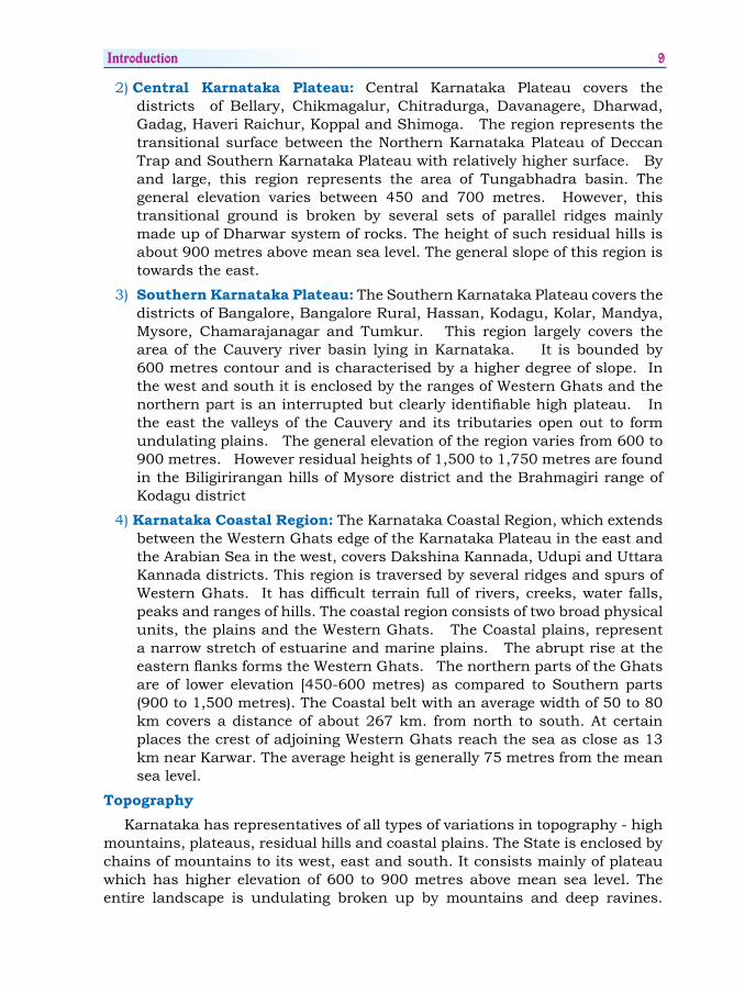
outturn of Major forest produceSl. No.
Type of production Unit 2001-02 2002-03 2003-04 2004-05 (p)
1. Timbera) Rose Wood Cubic mtrs. 8749 8401 7719 3342b) Teak Wood Cubic mtrs. 12002 4749 3752 2849c) Other kinds of timber Cubic mtrs. 67266 56573 52276 19802
2. Pulp wood Cubic mtrs. 129222 27180 28557 95433. Eucalyptus Cubic mtrs. 63393 299 4512 209554. Match Wood Cubic mtrs. 76 58 1502 1365. Sawn timber Cubic mtrs. 5121 6677 1329 596
6. Timber in round pole Cubic mtrs. 54056 38135 29711 46779
7. Fire wood Cubic mtrs. 313453 230099 257683 1437918. Bamboo 191152 202791 106061 9548099. Sandalwood Tonnes 62 95 70 24
Source: Forest Department outturn of minor forest produce
Sl.
No.Item Unit 2001-02 2002-03 2003-04 2004-05
1. Charcoal Tonnes 1171 1530 672 252. Cane M.Tonnes 1171 211297 219199 2152483. Rubber Tonnes 441592 0 3440 04. Cashewnuts 0 49 165 315. Ivory Kgs 47 42 45 06. Honey Tonnes 155 43 112 1057. Wax Tonnes 15 2 5 58. Barks Tonnes 1 1 8 49. Tamarind Tonnes 2856 1717 1081 1709
10. Oilseeds Tonnes 25 8 0 0
11. Oils (Eucalyptus & Rosha) Kgs. 0 0 0 0
12. Seegekai Tonnes 676 1045 1134 65413. Gums Tonnes 4 2 2 1814. Specis Tonnes 170 132 132 14515. Antavalakai Tonnes 433 442 2023 22616. Halamaddi
(Dhoopa) Tonnes 1 23 151 38
17. Seeds (Misc) Tonnes 452 1 70 4818. Alalekai Tonnes 441 118 1181 21619. Beedi leaves Tonnes 1028 507 357 189
Source: Forest Department.

Introduction 33
Revenue From forests
Year Timber Sandal Wood
Fire Wood Bamboo Misellaneous Total
2001-02 4153 121 818 298 4619 100092002-03 4667 230 708 395 4088 100882003-04 3941 297 519 209 13112 180782004-05 3808 1456 673 351 10607 16895
Source : Forest Department
About two lakh ha. of forest area is lost for non-forestry purposes since 1956 to 1986-87 and the details are as follows: For hydroelectric purposes : 22,194 ha, electricity lines 1,688 ha, roads: 330 ha, tanks - 35,840 ha, townships- 1,791 ha, mining -42,676 ha, agriculture - 67,217 ha, rehabilitation - 25, 820 ha, other purposes 6,357 ha and total 2,03,913 ha. The outturn of major forest produce for the year 1991-92 is as follows: 1) Timber - a) Rosewood 4,522 M3, b)Teak -3,376 M3 c)Other kinds of timber - 41,253 M3 2)Pulpwood - 213 M3 4)Matchwood - 131 M3, 5)Sawn Timber - 618 M3 6) Timber in round pole - 32,067 M3 7) Firewood - 1,66,039 M3, 8)Bamboo - 19,299 M.T. and Sandalwood 1,418 M3.
Though 20% of the land area is classified as forests (3,86 million ha) in the State, only about 11% is well wooded. The remaining area is in different stages of degradation. The State is facing shortage of fuel wood, fodder and timber as the demand has increased considerably due to the increase in population of both human and cattle. The forests in the State are managed as per the prescriptions of the working plans which are prepared for periods of 10 to 15 years after taking into consideration the type of forests, the condition of the existing crop, the demand for various forest produce and the requirements of the area for maintenance of ecological balance.
Karnataka Government has established many National Parks and Wild Life Sanctuaries to protect important species. The following is the list of National parks and Wildlife Sanctuaries (WS) and their year of establishment.
There are five National Parks and 21 wildlife sanctuaries covering an extent of 6,360 Sq. km. of the total forest area. They comprise of evergreen to scrub type of forests thus forming a network of representative ecosystem to conserve endangered species of plants as well as animals and birds. As per the 1989 census of the larger mammals, there were 257 tigers, 283 panthers, 4,418 elephants and 5,473 bisons. As per the Census of Wildlife population conducted during 1997-98 there were 395 tigers, 1,360 gaur, 6,185 elephants, 817 panthers, 2,324 bears, 15,760 wild bears, 23,850 deer, 8,484 bisons, 4,998 sambars and 957 foxes.

34A Handbook of Karnataka
National Park/SanctuaryArea in sq.km.
DistrictYear of
est.
1. Anshi N.P. 250 Uttara Kannada 1987
2. Bandipur N.P. 874 Mysore/Chamarajnagar 1974
3. Bannerghatta N.P. 104 Bangalore 1974
4. Kundremukh N.P. 600 Chikmagalur 1987
5. Nagarhole N.P. 643 Mysore and Kodagu 1974
6. Adichunchanagiri Peacock Sanctuary
0.84 Mandya 1981
7. Arabithittu 14 Mysore 1950
8. Bhadra W.S. 492 Chikmagalur and Shimoga 1974
9. Biligiranagana Temple W.S. 540 Mysore / Chamarajnagar 1987
10. Brahmagiri W.S. 181 Kodagu 1974
11. Mookambika W.S. 247 Dakshina Kannada/ Udupi
1974
12. Nugu W.S. 30 Mysore 1974
13. Sharavathy 431 Shimoga 1974
14. Someshwara 88 Dakshina Kannada/ Udupi
1974
15. Shettyhally W.S. 396 Shimoga 1974
16. Ranebennur Blackbuck W.S. 119 Dharwad 1974
17. Pushpagiri 103 Kodagu 1974
18. Cauvery W.S. 527 Mysore 1987
19. Tala Caouvery W.S. 105 Kodagu 1987
20. Melkote Temple W.S. 247 Mandya 1974
21. Ghataprabha Bird S. 30 Belgaum 1974
22. Dandeli W.S. 843 Uttar Kannada 1987
23. Ranganatittu Bird S. 0.67 Mandya 1940
24. Gudavi Bird S. 0.73 Shimoga 1989
25. Daroji Bear Sanctuary 55.87 ------ -----
26. Attiveri Bird Sanctuary 2.23 ------ -----NP - National Park; W.S - Wild life Sanctuary
Karnataka forests support 25% of the elephant and 10% of the tiger population of India. Many regions of Karnataka are as yet unexplored, so new species of flora and fauna are found periodically. The Western Ghats, a biodiversity hotspot, includes the western region of Karnataka. Two sub-clusters in the Western Ghats, viz. Talacauvery and Kudremukh, both in Karnataka, are on the tentative list of World Heritage Sites of UNESCO. The Bandipur and Nagarahole National Parks, which fall outside these subclusters, were included

Introduction 35
in the Nilgiri Biosphere Reserve in 1986, a UNESCO designation. The Indian roller and the Indian elephant are recognized as the state bird and animal while sandalwood and the lotus are recognized as the state tree and flower respectively.
Anshi National Park: is located in Uttara Kannada district, in the Indian state of Karnataka, bordering the state of Goa. The 340 square kilometres park adjoins the Dandeli wildlife sanctuary, and together with six other protected areas in the states of Goa and Maharashtra, forms a protected forest area of over 2200 square kilometres. The park is a habitat of melanistic leopards, tigers and elephants, amongst other fauna. The forest in the area was declared the Dandeli wildlife sanctuary on 10 May 1956. The state proposed carving out a section of the sanctuary to form the Anshi national park, and the proposal was implemented on 2 September 1987. The initial proposal covered 250 square kilometres. When the final notification of the park area was issued in 2002, it was extended by another 90 square kilometres. Anshi and Dandeli were granted the status of Project Tiger sanctuaries in January 2007. Located in the Western Ghats range, Anshi’s altitude varies from 200 m to 925 m above sea level. The park is situated in the North Western Ghats montane rain forests and North Western Ghats moist deciduous forests eco regions, both of which are deemed endangered by the World Wildlife Fund. Anshi National Park and the adjoining Dandeli wildlife sanctuary together form the Dandeli Wildlife Division of the Karnataka Forest Department, headed by a Deputy Conservator of Forests. The forests in the area are rich in flora and fauna. Trees and plants that can be found here include Bamboo, Bauhinia, Eucalyptus, Lantana, Silver Oak, Teak and Xylia xylocarpa. A variety of Bonnet Macaque, deer (barking, mouse and spotted), Indian bison, Malabar Civet, Malabar giant squirrel, pangolin and sloth bear make their home in the forests of the park. Besides, the black panther, elephants and tigers are rare species found in the park. Reptiles spotted in the park include the King Cobra, Krait, Python, Rat snake and Viper. Around 200 species of birds are recorded in the park. These include the Adjutant Stork, Ashy Woodswallow, Black-crested Bulbul, Blue-headed Pitta, Brahminy Kite, Broad-billed Roller, Crested Serpent Eagle, Great Hornbill, Golden-backed Woodpecker, Malabar Pied Hornbill, Sri Lanka Frogmouth and Yellow-footed Green Pigeon.
Bandipur National Park: is one of India’s best known sanctuaries, and is an important Project Tiger reserve. It is located in the Chamarajanagar district of southern Karnataka in south India, and is contiguous with the Mudumalai National Park in the neighbouring state of Tamil Nadu, the Wynad Wildlife Sanctuary in Kerala, and the Nagarhole National Park to the northwest. It is home to around seventy tigers and over three thousand Asian elephants (as per the 1997 census ), along with leopards, dholes, gaur and sloth bears. Bandipur is part of the Nilgiri Biosphere Reserve. The Western Ghats, Nilgiri Sub-Cluster (6,000+ km²), including all of Bandipur National Park, is under consideration by the UNESCO World Heritage Committee for selection as a World Heritage Site. A sanctuary of 90 km² was created at this site in the Bandipur Reserve

36A Handbook of Karnataka
Forest in 1931. As it was realized that this was too small for effective wildlife conservation, leading to the instituting of the Venugopala Wildlife Park at this site, extending over 800 km². The Bandipur Tiger Reserve was constituted in 1973 by carving out 880 km² from the Wildlife Park. Recognized under Project Tiger in 1973 this park has boasted constant rise in Tiger population. Also famous for Sandalwood trees and rare species of Flora. Bandipur National Park’s altitude is between 680-1454 metres and is situated south of the Kabini river at the foothills of the Western Ghats.The rivers of Kabini, Nagur and Moyar flow through the reserve. Climate - Winter minimum 10, Summer maximum 28 degrees, Monsoon from June to September and best time to visit is open throughout the year but preferably in monsoon when wildlife is plenty and forest is green. Greenery is quite lean when viewed from road but gets thicker as we proceed into the forest.
Major flora: Teak (Tectona grandis), Dalbergia latifolia, Pterocarpus marsupium, Adina cordifolia, Grewia tiliaefolia, Emblica officinalis, Lagerstroemia lanceolata, Terminalia tomentosa, Anogeissus latifolia, Terminalia chebula, Schleichera trijuga, Odina wodiar, Butea monosperma, Cassia fistula, Dendrocalamus strictus, Bambusa arundinacea , Chloroxylon swetenia, Acacia catechu, Shorea talura, Randia uliginosa. major fauna: Tiger, Leopard, Elephant, Gaur, Sambar (deer), Chital, Sloth Bear, Mouse deer, Wild dog, Wild boar, Barking deer, Four horned Antelope, Hyena. Endangered species: Tiger, Four horned Antelope, Gaur, Elephant, Panther, Sloth Bear, Crocodiles, Mouse deer, Python, Osprey. Birds: Grey Junglefowl, Pompadour Green Pigeon, Honey Buzzard, Red-headed Vulture, Grey-headed Fish Eagle, Brown Hawk Owl, Bay Owl, Malabar Trogon, Nilgiri Flycatcher, Malabar Pied Hornbill, Little Spiderhunter, Plain Flowerpecker. Reptiles: King Cobra, Common Cobra, Python, Adder, Viper, Rat Snake, Water Snake, Marsh Crocodile, Lizard, Chameleon, Monitor Lizard, Frog, Tree frog, Toad and Tortoise.
CeNSuS FIGuReS FoR BANDIPuR
1991 1993 1995 1997Tiger 58 66 74 75Leopard 51 81 86 88Elephant 1107 2214 2214 3471Gaur 1097 1373 1373 2427Dhole 148 181 181Chital 3333 5858 5858 8204Sambar 706 1196 1196 2386Slothbear 51 66 66Chousingha 14Langur 1468 1751 1751Pig 148 181 181Muntjac 72 131 131

Introduction 37
Bannerghatta National Park: is situated 22 km south of Bangalore, Karnataka, India. The journey to the park takes nearly half an hour from Bangalore. This hilly place is the home for one of the richest natural, zoological reserves. The 25,000 acre (104.27 km²) zoological park makes this a major tourist attraction of Bangalore. The Bannerghatta Tiger and Lion Reserve has a reserve of Indian tigers including white tigers, lions and other mammals. Safaris - Tiger & Lion Safari and Grand Safari (including herbivores) - conducted by the KSTDC,aid in the funding of the reserve. The Tiger Reserve of the park has been recognised by the Forest Department of India. There is a small museum in the zoo which showcases zoological exhibits. The zoo, which is a major attraction in this area, also has a reptile park and a small theatre. The Zoo is closed on Tuesdays (weekly holiday). The country’s first Butterfly Park was established at the Bannerghatta Biological Park. The Butterfly Park is spread across 7.5 acres (30,000 m2) of land. It comprises a butterfly conservatory, museum and an audio-visual room. The butterfly conservatory has a polycarbonate roof and is a 10,000 sq ft (1,000 m²). circular enclosure, inside which the living environment has been carefully designed to support over 20 species of butterflies. The environment has a tropical setting — complete with the humid climate, an artificial waterfall, a narrow walking bridge and host plants and shrubs that attract butterflies. The conservatory leads to the second and third domes, which house the museum containing dioramas and exhibits of carefully preserved, exquisite butterflies. The collaborative agencies are the Zoo Authority of Karnataka, University of Agricultural Sciences and the Ashoka Trust for Research in Ecology and Environment (ATREE).
The Kudremukh National Park: is the second largest declared Wildlife Protected Area (600.32 km²) of a tropical wet evergreen type of forest in the Western Ghats. Kudremukh National Park is located in Udupi and Chikmagalur districts of Karnataka states. The Western Ghats is one of the thirty four hot spots identified for bio-diversity conservation in the world. Kudremukh National Park comes under the Global Tiger Conservation Priority-I, under the format developed jointly by Wildlife Conservation Society (WCS) and World Wide Fund-USA. The British Government declared Kudremukh region as a Reserved Forest in 1916, to stop rampant slash and burn cultivation practices from penetrating deeper into the Ghats. Well known environmentalist and Tiger expert Dr. Ullas Karanth, undertook a detailed and systematic survey of the distribution of the endangered Lion Tailed Macaque in Karnataka during 1983-84 with support from Government of Karnataka. He observed that suitable and extensive rainforest habitat for Lion-tailed Macaque existed in Kudremukh and that the tract probably harbored the largest contiguous population of lion tailed macaques in the Western Ghats outside the Malabar region. He further suggested that Lion Tailed Macaques could be effectively used as a ‘flagship’ species to conserve the entire biotic community in the region and prepared a conservation plan for survival of wild population of Lion Tailed Macaques in the

38A Handbook of Karnataka
region delineating the present national park area as a proposed nature reserve. Based on his report, the Karnataka State Wildlife Advisory Board suggested to the Government that Kudremukh National Park be created. Subsequently, the first notification of the Kudremukh National Park was issued. In 1987, the Government of Karnataka declared these Reserved Forests as a National Park based on the above suggestion.
The town of Kudremukh is primarily an iron ore mining town where the government run Public Sector Kudremukh Iron Ore Company Ltd. (KIOCL) operates. It is noted for its scenic beauty. Owing to the dense forests, sighting wildlife can be challenging, though the area is rich in wildlife. Nonetheless the drive through the forest ranges can be enchanting and exhilarating. Three important rivers, the Tunga, the Bhadra and the Nethravathi are said to have their origin here. A shrine of goddess Bhagavathi and a Varaha image, 1.8 m within a cave are the main attractions. The Tunga river and Bhadra river flow freely through the parklands. Kadambi waterfalls area is the definite point of interest for anyone who travels to the spot. A diverse assemblage of endangered large mammals is found in the park supporting three large mammal predator species Tiger, Leopard and Wild Dogs. The important Tiger prey base found within the Park is Gaur, Sambar, Wild Pig, Muntjac, Chevrotain, Bonnet Macaque, Common Langur and the Lion Tailed Macaque. The wet climate and the tremendous water retentive capacity of the shola grasslands and forests has led to the formation of thousands of perennial streams in the region converging to form three major rivers of the region, Tunga, Bhadra and Nethravathi that form an important lifeline for the people of Karnataka and Andhra Pradesh. Lobo house is an old abandoned house on top of Kuduremukha.
Nagarhole National Park: also known as ‘Rajiv Gandhi National Park, is located 94 km from Mysore. It is spread between Kodagu and Mysore districts. Located to the northwest of Bandipur National Park, Kabini reservoir separates the two. The exclusive hunting reserve of the former rulers of Mysore, the park has rich forest cover, small streams, valleys, and waterfalls. In 1975 its area stretched to 575 km². The place derives its name from Kannada, Naga meaning snake and hole referring to streams. Set up in 1955, it is one of the best-managed parks in the country. The climate is tropical; summer is hot and winter is pleasant. The park boasts a healthy tiger-predator ratio, and tiger, bison, and elephant are much more populous here than in Bandipur. The park is part of the Nilgiri Biosphere Reserve. The Western Ghats, Nilgiri Sub-Cluster (6,000+ km²), including all of Nagarhole National Park, is under consideration by the UNESCO World Heritage Committee for selection as a World Heritage Site. Mostly moist mixed deciduous forest (Tectona grandis, Dalbergia latifolia) in the southern parts, dry tropical forest (Wrightia tinctoria, Acacia) towards the east, and Sub mountain hill valley swamp forest (Eugenia) are found in the Park. Mammals: Elephant, Jackal ,Tiger, Panther, Gaur, Muntjac, Sambar, Spotted deer, Mongoose, Civet cat, Hyena. Reptiles: King Cobra, Krait, Python,
Introduction 39
Viper, Tortoise, Monitor Lizard ,Toads etc. The main trees found are Rosewood, Teak, Sandalwood and Silver oak.
Western Ghats in Karnataka
The Nilgiri Bio-sphere is home to the largest population of Asian Elephants and forms an important Project Elephant and Project Tiger reserve. Brahmagiri and Pushpagiri wildlife sanctuaries are important elephant habitats. Karnataka’s Ghat areas hold over six thousand elephants (as of 2004) and ten percent of India’s critically endangered tiger population. The largest population of India’s Tigers outside the Sundarbans is in the unbroken forests bordering Karnataka, Tamil Nadu and Kerala. The largest numbers and herds of vulnerable Gaur are found here with the Bandipur National Park and Nagarahole together holding over five thousand Gaur. To the west the forests of Kodagu hold sizeable populations of the endangered Nilgiri Langur. Bhadra Wildlife Sanctuary and project tiger reserve in Chikmagalur has large populations of Indian muntjac. Many Asian Elephant, Gaur, Sambar, vulnerable Sloth Bears, Leopard, tiger and Wild Boars dwell in the forests of Kerala.
Bannerghatta National Park and Annekal reserve forest is an important elephant corridor connecting the forests of Tamil Nadu with those of Karnataka. Dandeli and Anshi national parks in Uttara Kannada district are home to the Black Panther and normal variety of leopards and significant populations of Great Indian Hornbill. Bhimgad in Belgaum district is a proposed wildlife sanctuary and is home to the endemic critically endangered Wroughton’s freetailed bat. The Krishnapur caves close by are one of only three places in the country where the little-known Theobald’s tomb bat is found. Large Lesser False Vampire bats are found in the Talevadi caves.
l Reptiles- The snake family Uropeltidae of the reptile class is almost entirely restricted to this region.
l Amphibians- The amphibians of the Western Ghats are diverse and unique, with more than 80% of the 179 amphibian species being endemic to the region. Most of the endemic species have their distribution in the rainforests of these mountains. The endangered Purple frog was discovered in 2003 to be a living fossil. This species of frog is most closely related to species found in the Seychelles. Four new species of Anurans belonging to the genus Rhacophorus, Polypedates, Philautus and Bufo have been described from the Western Ghats.
l Fish- 102 species of fish are listed for the Western Ghats water bodies. Western Ghats streams are home to several brilliantly coloured ornamental fishes like Red line torpedo barb, Red-tailed barb, Osteobrama bakeri, Günther’s catfish and freshwater puffer fish Tetraodon travancoricus, Carinotetraodon imitator and marine forms like Chelonodon patoca (Buchanan-Hamilton,1822); mahseers such as Malabar mahseer.

40A Handbook of Karnataka
l Birds- There are at least 508 bird species. Most of Karnataka’s five hundred species of birds are from the Western Ghats region. Bhadra Wildlife Sanctuary is located at the northern end of the Malabar ranges and the southern tip of the Sahyadri ranges and bird species from both ranges can be seen here.
l Insects- There are roughly 6,000 insect species from Kerala alone. Of 334 butterfly species recorded from the Western Ghats, 316 species have been reported from the Nilgiri Biosphere Reserve.
l Molluscs- Seasonal rainfall patterns of the Western Ghats necessitate a period of dormancy for its land snails, resulting in their high abundance and diversity including at least 258 species of gastropods from 57 genera and 24 families.
In 2006, India applied to the UNESCO MAB for the Western Ghats to be listed as a protected World Heritage Site. This will be composed of 7 adjoining areas. The areas within the State of Karnataka are:
Western Ghats—Talacauvery Sub-Cluster (with Six Site Elements): All site elements in the Talacauvery region are situated in Karnataka state except the Aralam Reserved Forest (RF) in Kerala state. Pushpagiri Wildlife Sanctuary (92.65 km²) has dense evergreen and semi-evergreen vegetation, with shola-grassland in areas of higher elevation. The steep terrain of the Sanctuary has resulted in scenic waterfalls along its many mountain streams. Altitude varies from 160 to 1,712 m, the highest point being the Pushpagiri Peak in the north of the park. Temperatures range from 10-38°C, with annual rainfall exceeding 6,500 mm. Brahmagiri Wildlife Sanctuary (181.29 km²) also consists of evergreen and semievergreen forests in the lower-lying areas with shola-grassland habitat in the higher altitudes. The eastern tip of the Sanctuary is adjacent to the north-western boundary of Rajiv Gandhi (Nagarahole) National Park, separated by a narrow strip of coffee plantations. The highest point in the Sanctuary is the Brahmagiri Peak on the south-eastern boundary, while elevation varies between 65 m and 1,607 m. Temperatures range from 5°-32° C, and mean annual rainfall varies from 2,500 mm to 6,000 mm. Talacauvery Wildlife Sanctuary (105.01 km²) is located in the Kodagu (Coorg) district of Karnataka. Its forests are predominated by tropical evergreen forests. It is named after Talacauvery the origin of the Cauvery river which lies on the eastern edge of the Sanctuary. Altitudinal and temperature ranges are 64-1,659 m and 10°-35° C, respectively. Annual rainfall is above 6,500mm. The areas between Talacauvery and Pushpagiri sanctuaries have been excluded from the proposed area mainly due to the fragmentation and habitat degradation caused by the Mangalore-Madikeri road. There is no natural forest cover for about 2 km on either side of this road. There are some teak and rubber plantations near the road.

Introduction 41
Western Ghats—Kudremukh Sub-Cluster: (with Five Site Elements): The Kudremukh National Park, Someshwara Wildlife Sanctuary, and surrounding Reserved Forests of Someshwara, Agumbe and Balahalli of Karnataka state are situated centrally in the Western Ghats Biodiversity Hotspot. Kudremukh National Park has one of the most beautiful landscapes in the Western Ghats, encompassing evergreen, semi-evergreen and grasslandshola habitat characteristic of high altitude Western Ghats regions. Altitude varies from 120 to 1,892 m, the highest point being the Kudremukh Peak in the south of the Park. The Park has average temperatures ranging between 17° C and 28° C. Annual rainfall varies from 1,778 mm to 6,350 mm, with an average of 4,000 mm and a maximum recorded rainfall of 10,000 mm in 1994. The topography is mountainous with a central ridge running north-south through the Park. The Park is dotted with crystal-clear streams and picturesque waterfalls. Kudremukh National Park is flanked by coffee and tea estates on the north and east, whereas on the west, the land drops down to the Arabian Sea. In the northwest is a forest corridor that connects the Park with the Someshwara Wildlife Sanctuary. The Sanctuary, named after the famous Someshwara Temple located within it, and the adjoining 105.3 km² of Reserved Forest are predominantly evergreen forests, along with semi-evergreen vegetation. These Reserved Forests are in the process of being included within the Sanctuary. Elevation ranges from 75-870 m and the temperature varies between 20° C and 30° C, with an average annual rainfall of 6,000 mm.
environment Situation in Karnataka
Survival of life on earth depends on the availability of natural resources. The use of these resources has an impact on the environment around us. Water usage leads to its pollution. Coal, oil, minerals and metals are being depleted by increasing usage. A high level of irrigation, unless accompanied by proper drainage, make the soil saline or water logged. Combustion of fuels results in greater accumulation of carbon dioxide leading to global warming. This use and depletion of resources has an Impact on our environment.
About sixty per cent of the land area in the States is under one or other type of agriculture. This is above the national average of 51%. A portion of this land is marginal for agriculture and requires higher inputs but gives lower yields. As subsistence farming is economically nonviable, this land is soon degraded and the soil is eroded. Land that cannot support agriculture could well be suitable for forestry and pasture.
Irrigated land has been rendered saline or water-logged due to water use. Thus in the upper Krishna Project about 71,000 ha, have become either saline or alkaline. In the command area of the Tungabhadra reservoir about 33,000 ha, are either saline or water logged; 24,455 ha are saline or waterlogged in the Malaprabha and Ghataprabha (command) area and 16,500 ha, in the Cauvery basin. Remedial measures are being undertaken in some areas at a high cost.

42A Handbook of Karnataka
Pasture lands in the State have been steadily decreasing. During 1956 to 1983, pastures came down by 31% while animal units increased by 30%. Over-grazing is bound to follow together with compacting of the land cattle paths.
As a result of the expansion of agriculture and its allied activities, the natural vegetation in the plains has suffered the most. In fact the characteristic vegetation of this habitat namely the scrub forest has almost vanished. The wild life too has practically been wiped out in this tract except in isolated pockets. Similarly in the Western Ghats, the fragmentation of natural vegetation has already reached alarming proportions and this would have serious consequences on the rate of extinction of species. The wild life has been decimated in many parts of the State and its numbers are rapidly dwindling due to loss of habitat, constant fragmentation and illegal killing.
The forest areas in the Western Ghats are being converted into plantations of cardamom, cocoa, rubber, coffee and tea. Simultaneously timber and fuel wood species are replacing the rich tropical forests. These plantations while being commercially remunerative can cause great harm to the bio-diversity and habitat of the flora andfauna. Vast forest areas have been submerged by hydel projects on the west-flowing rivers. Resettlement of the people displaced by development projects has further reduced the forest area by honey combing the forests with human settlement.
Silting is the most serious problems with tanks and reservoirs. The capacity of the tanks goes on decreasing every year, the tank irrigating less and less land, ultimately becoming altogether useless for irrigation when the sluices can no longer be opened. The solution proposed for the silting problem is afforestation of the catchment to the extent possible, banning cultivation in the foreshore lands and construction of small checkdams upstream to trap the silt.
The exploitation of renewable and non-renewable natural resources is likely to have an environmental impact. Increased production of minerals will vary with the location, method and magnitude of operations. Area surrounding the mines will also be affected by the works as well as workers. So the extent and mode of mining must be regulated by ecological considerations for the long term utilisation of resources.
Pollution is the introduction of extraneous materials into environment adversely affecting its normal use. Water pollution is caused mainly by discharge of waste waters into natural water courses and water bodies. Water is being polluted by industries and human habitations. Industrial effluents can cause organic, chemical and even hazardous pollution. In order to control this pollution, effluent standards have been prescribed industry-wise. Thermal pollution caused by water with temperatures above the ambient water temperature is also to be controlled. The Water (Prevention and Control of Pollution) Act was enacted by Parliament on 23rd March 1974,

Introduction 43
The greatest water pollution in the State is caused by Urban Agglomerations. It is obligatory on the authorities to treat the sewage before discharging it. However 139 of the 172 Municipalities do not have functional underground drainage or sewage treatment plants.
Air pollutionStack emissions from industries also emits fumes containing both suspended
particles as well as abnoxious gases. Stack emission are to be controlled and have to conform to standards using devices like cyclones, scrubbers, electrostatic precipitators and similar devices. The resultant particulate matter gives a sludge which again has to be disposed off. The Raichur Thermal power plant produces around 3,000 tonnes of ash a day. The Mangalore Super Thermal Power Plant is estimated to generate 20,000 tonnes of ash a day. A step towards controlling pollution and protection of our environment was taken by the Central enactment of Air (Prevention and Control of Pollution) Act 1981.
Noise pollution caused by 1) Industrial Noise, 2) Traffic Noise, 3) Cultural Noise is also under the purview of this Air (Prevention and Control of Pollution) Act of 1981. Noise is as harmful to the human being as polluted air and water. Noise pollution associated with urban life is on the increase. The vast majority of people are under the false impression that ears adapt to increased noise levels. The truth is that they never do, but silently surrender their functions, with increasing age of an individual.
More comprehensive legislation to provide for the protection and improvement of the environment was Centrally enacted and termed the Environment (Protection) Act on 23rd May 1986.
The Department of Ecology and Environment was established in March 1981 to have an integrated approach to deal with, prevention and control of air and water pollution, preservation and development of forest wealth and other natural resources in the State. The Environment (Protection) Act came into force from November 1986 and the existing Water Act and Air Act have been amended over the last two years. The new provisions of the environmental laws enable the general public to question the authorities involved in the environmental pollution control in a court of law. The Ecology and Environment department is now responsible for the management of hazardous chemicals and control of oil pollution in coastal waters. In addition beach management has also been given considerable importance.
Karnataka State Pollution Control BoardThe Karnataka State Board for Prevention and Control of Water Pollution
was constituted by the Government of Karnataka on 21st September 1974 in pursuance of the Water(Prevention and Control of Water Pollution) Act 1974. After the enactment of the Air (Prevention and Control of Pollution) Act 1981, the enforcing responsibility was entrusted to the Board. The Board was later renamed as Pollution Control Board in 1985.

44A Handbook of Karnataka
The Board is also enforcing the following Acts and Rules viz 1) The Water (Prevention and Control of Pollution) Cess Act, 1977 as amended by the Amendment Act 1991; 2) The Water (Prevention and Control of Pollution) cess rules 1978; 3) the rules framed under Environment (Protection) Act 1986 a) Hazardous waste (Management and handling) rules 1989 and b) Manufacture, Storage and Import of Hazardous Chemicals rules 1989 and 4) The Public Liability Insurance Act 1991.
The Board has identified 9,012 industries upto 31st March 1999 under pollution control laws. There are 120 highly polluting industries, 437 industries have been identified under the Hazardous Waste (Management and Handling) Rules 1989. The total quantity of hazardous waste generated in the State is 33,282 MT/Annum. (Recyclable/Reusable -13,313 MT/Annum, Incinerable - 3,328 MT/Annum and Land fill - 16,641 MT/Annum. During 1998-99 Environment clearance have been granted to 124 industries. About 888 toilets and 7 crematoriums have been completed under National River Water Conservation Programmes by the State Pollution Control Board, Urban Water Supply and Drainage Board.
Seismicity of Karnataka
The area of Karnataka state lies in a zone which is affected by the earthquakes less frequently. According to the available records, the area had been affected by:- Bellary earthquake of 1st April, 1843 (Magnitude = 6.0), Coimbatore earthquake of 8th Feb. 1900 (Magnitude = 6.0), and Latur (Killari) earthquake of 29th Sept. 1993 (Magnitude 6.3). The maximum intensity due to these earthquakes in the Karnataka state has been estimated between VII & VIII on the Modified Mecalli. Besides, the earthquake of May 12th, 1975 (Magnitude = 5.0) near Dharwar was widely felt in Karnataka and the earthquake of 20th March 1984 (Magnitude = 4.5) was also felt at Bangalore and adjoining area.
Recently, on January 9th 1996, an earthquake of slight intensity (Magnitude + 4.5) on Richter scale occurred in Dharwar District of Karnataka. This earthquake was widely felt in the state. A list of important earthquakes that could have been experienced in the region is given in next page.
A swarm type of earthquake activity (Magnitude below 2.5 on the Richter scale) has also been experienced in the Karnataka state time to time. Mention may be made of 1955 swarm in Bijapur District, 1956 swarm in Bidar District 1965 swarm in Bijapur District, 1956 Swarm in Bidar District, 1965 Swarm in Kolar District, 1972 swarm in Mandya District and 1980 swarm in Hospet Taluk.
In the seismic zoning map of India prepared under the auspices of Bureau of India Standards (BIS), the area of Karnataka state lies in the zone I, II& III. The seismic zone I, II & III broadly associated with a maximum intensity of V, VI & VII on the Modified Mecalli Scale.

Introduction 45

46A Handbook of Karnataka
Area – Population and Administrative Divisions in Karnataka
District Area (Sq.km) % of State Population
(2011)% of State
Density (2011)
No. of Taluks
No. of Hoblis
Bangalore 2190 1.14 9588910 15.69 4378 4 17
Bangalore Rural 2259 1.18 987257 1.61 441 4 17
Ramanagara 3556 1.85 1082739 1.77 303 4 18
Chitradurga 8440 4.40 1660378 2.72 197 6 22
Davangere 5924 3.09 1946905 3.18 329 6 24
Kolar 3969 2.07 1540231 2.52 384 5 27
Chikballapur 4254 2.22 1254377 2.05 298 6 26
Shimoga 8477 4.42 1755512 2.87 207 7 40
Tumkur 10597 5.53 2681449 4.39 253 10 50
Chikmagalur 7201 3.75 1137753 1.86 158 7 34Dakshina Kannada 4560 2.38 2083625 3.41 457 5 17
Udupi 3880 2.02 1177908 1.93 304 3 9
Hassan 6814 3.55 1776221 2.91 261 8 38
Kodagu 4102 2.14 554762 0.91 135 3 16
Mandya 4961 2.59 1808680 2.96 365 7 31
Mysore 6854 3.57 2994744 4.90 437 7 33
Chamarajanagar 5101 2.66 1020962 1.67 200 4 16
Belgaum 13415 6.99 4778439 7.82 356 10 35
Bijapur 10494 5.47 2175102 3.56 207 5 18
Bagalkot 6575 3.43 1890826 3.09 288 6 18
Dharwad 4260 2.22 1846993 3.02 434 5 14
Gadag 4656 2.43 1065235 1.74 229 5 11
Haveri 4823 2.51 1598506 2.61 331 7 19
Uttara Kannada 10291 5.37 1436847 2.35 140 11 35
Bellary 8450 4.41 2532383 4.14 300 7 27
Bidar 5448 2.84 1700018 2.78 312 5 30
Gulbarga 10990 5.73 2564892 4.20 233 7 32
Raichur 6827 3.56 1924773 3.15 228 5 37
Koppal 7189 3.75 1391292 2.28 250 4 20
Yadgiri 5234 2.73 1172985 1.92 224 3 16
State 191791 100 61130704 100 319 176 747

Introduction 47
District
Gram Pancha-
yats 2007-08
Towns / Urban Agglome- rations 2011
Munici- palities/ Corpora-
tions 2011
Inhabited villages (2011)
Un- Inhabited villages (2011)
Sex Ratio 2011
Pop. Growth rate (%)2001-11
Bangalore 86 19 2 668 31 908 36.86
Bangalore Rural 98 6 5 949 101 945 1.65Ramanagara 130 4 4 770 53 976 0.63Chitradurga 185 6 6 946 113 969 1.72Davangere 230 6 6 810 113 967 1.88Kolar 156 6 6 1598 199 976 1.85Chikballapur 151 6 6 1321 193 968 1.27Shimoga 260 9 9 1443 87 955 1.36Tumkur 321 11 10 2574 134 979 1.17Chikmagalur 226 9 9 1034 83 1005 -0.04Dakshina Kannada
203 20 8 354 - 1018 2.25
Udupi 146 6 4 248 - 1093 0.79Hassan 258 9 8 2394 165 1005 0.66Kodagu 98 5 4 291 5 1019 0.07Mandya 232 8 7 1369 110 989 0.54
Mysore 235 11 10 1216 124 982 4.27Chamarajanagar 120 4 5 424 85 989 0.67
Belgaum 485 22 17 1255 15 969 6.81Bijapur 199 6 6 660 17 954 4.45Bagalkot 161 12 11 623 4 984 2.89Dharwad 127 6 6 361 18 967 2.93Gadag 106 9 9 329 8 978 1.13Haveri 208 9 8 691 7 951 1.92Uttara Kannada 207 13 11 1246 43 975 1Bellary 189 11 10 524 30 978 6.1Bidar 175 6 6 599 22 952 2.39Gulbarga 220 17 11 873 45 962 4.71
Raichur 164 9 7 830 53 992 3.08
Koppal 134 5 4 594 35 983 2.36
Yadgiri 117 - 4 487 32 984 2.62
State 5627 270 219 27481 1925 968 100
Area – Population and Administrative Divisions in Karnataka

48A Handbook of Karnataka
List of earthquakes from IMD Catalogue occurring between Lat 11.50 To 18.50 Deg. N And Long 74.00 To 78.00 Deg. e for The Period
1505 To 1997.
DATE O-TIME LAT LONG DPTH MAG1843-4-1 000.0 15.00 76.00 0.00 6.01916-1-7 000.0 13.00 77.00 0.00 5.01984-3-20 104529.5 12.82 77.43 21.00 4.51985-5-27 65712.0 17.20 74.00 33.00 0.01985-12-15 131052.0 17.36 74.00 39.00 0.01987-2-2 91838.0 17.30 74.10 10.00 0.01988-9-11 203914.0 17.23 74.00 37.00 4.31992-10-18 17333.2 18.10 76.90 33.00 4.41992-11-2 070.2 18.20 76.60 33.00 3.91993-9-29 222547.5 18.07 76.62 12.00 6.31993-9-29 231057.5 18.00 76.40 10.00 5.01993-9-30 05313.0 18.00 76.50 12.00 4.71993-9-30 21656.3 18.10 76.60 12.00 4.51993-9-30 33146.0 18.20 76.60 12.00 3.81993-10-1 17116.8 17.90 76.60 12.00 4.41993-10-2 231530.5 17.90 76.60 12.00 3.61993-10-4 211934.8 18.00 76.60 12.00 3.91993-10-8 2045.73 18.00 76.70 33.00 4.61993-10-16 85811.6 18.00 76.50 15.00 3.31993-10-17 0.712.3 17.90 77.20 1.00 3.81993-10-18 18939.9 17.90 76.60 2.00 3.51993-10-28 192117.4 18.00 76.50 1.00 3.21993-11-1 62844.3 18.00 76.80 21.00 3.41993-11-12 132731.0 18.00 76.60 3.00 5.01993-11-13 4212.2 18.10 76.60 4.00 3.41993-11-18 14131.6 18.30 76.80 33.00 0.01993-11-24 14461.6 18.00 76.60 1.00 4.41995-12-21 63153.0 18.00 76.50 33.00 1.21993-1-5 11845.0 16.30 74.30 33.00 0.01996-1-9 24515.0 15.20 75.40 33.00 4.51996-1-29 132345.5 18.10 76.50 33.00 2.51996-9-2 195336.0 18.10 76.60 0.00 3.01996-11-10 904.1 18.30 76.69 33.00 4.11997-1-23 23446.0 17.44 76.06 33.00 0.01997-2-21 93739.0 18.00 76.60 0.00 3.2
No. of Earthquakes = 35