Chapter 8: Urban Design and Visual Resources A. … chapter considers the potential effects of the...
24
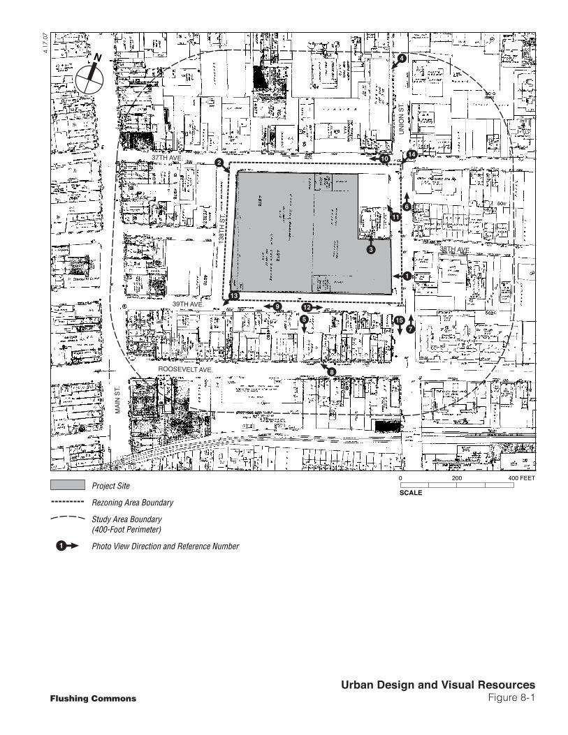
8-1 Chapter 8: Urban Design and Visual Resources A. INTRODUCTION This chapter considers the potential effects of the proposed Flushing Commons project on urban design and visual resources. The project site occupies most of the block bounded by 37th and 39th Avenues and Union and Main Streets in the Flushing section of Queens. Views to and from the project site are limited primarily to the immediately surrounding streets. Therefore, the study area for urban design and visual resources has been defined as being within 400 feet of the project site (see Figure 8-1). As defined in the 2001 New York City Environmental Quality Review (CEQR) Technical Manual, urban design components and visual resources determine the “look” of a neighborhood—its physical appearance (including the size and shape of buildings), the arrangement of the buildings on blocks, the street pattern, and noteworthy views that may give an area a distinctive character. B. PRINCIPAL CONCLUSIONS The Flushing Commons project would greatly improve the urban design characteristics of the current site, an underutilized paved parking lot. The proposed project would replace the one- story parking structure with five new buildings of various heights (which would create new streetwalls) and public open spaces. The Flushing Commons project, as well as the proposed Macedonia Plaza project, would add new uses and vitality to the site and improve the overall appearance of the site. The Flushing Commons buildings would be organized around the central open space with walkways to adjacent streets and provide a significant open space that is currently missing from the urban fabric of Downtown Flushing—a town square. The open space would be open to the public at all times and available for programming for public events. The Macedonia Plaza project would be directly adjacent to the Macedonia AME Church, creating a new notable presence at the corner of Union Street and 37th Avenue. It would also provide 18,834 square feet of private open space in the interior of the project block, which would be anticipated to enhance the site’s visual appearance. The residential, commercial, and community facility uses of the proposed buildings would be consistent with the predominant uses in the study area. There is a wide variety of building styles and materials used in the area; thus, the design of the buildings and mix of materials would be in keeping with what is currently found in the study area. While the new buildings would be taller and have larger footprints than some of the buildings in the surrounding area, they would be in keeping with other large-scale developments in the area, including the Queens Crossing development and the condominium building to the south of the site. The proposed project would not have an adverse impact on the street pattern, block shapes, and natural features of the study
Transcript of Chapter 8: Urban Design and Visual Resources A. … chapter considers the potential effects of the...

8-1
Chapter 8: Urban Design and Visual Resources
A. INTRODUCTION This chapter considers the potential effects of the proposed Flushing Commons project on urban design and visual resources. The project site occupies most of the block bounded by 37th and 39th Avenues and Union and Main Streets in the Flushing section of Queens. Views to and from the project site are limited primarily to the immediately surrounding streets. Therefore, the study area for urban design and visual resources has been defined as being within 400 feet of the project site (see Figure 8-1).
As defined in the 2001 New York City Environmental Quality Review (CEQR) Technical Manual, urban design components and visual resources determine the “look” of a neighborhood—its physical appearance (including the size and shape of buildings), the arrangement of the buildings on blocks, the street pattern, and noteworthy views that may give an area a distinctive character.
B. PRINCIPAL CONCLUSIONS The Flushing Commons project would greatly improve the urban design characteristics of the current site, an underutilized paved parking lot. The proposed project would replace the one-story parking structure with five new buildings of various heights (which would create new streetwalls) and public open spaces. The Flushing Commons project, as well as the proposed Macedonia Plaza project, would add new uses and vitality to the site and improve the overall appearance of the site.
The Flushing Commons buildings would be organized around the central open space with walkways to adjacent streets and provide a significant open space that is currently missing from the urban fabric of Downtown Flushing—a town square. The open space would be open to the public at all times and available for programming for public events.
The Macedonia Plaza project would be directly adjacent to the Macedonia AME Church, creating a new notable presence at the corner of Union Street and 37th Avenue. It would also provide 18,834 square feet of private open space in the interior of the project block, which would be anticipated to enhance the site’s visual appearance.
The residential, commercial, and community facility uses of the proposed buildings would be consistent with the predominant uses in the study area. There is a wide variety of building styles and materials used in the area; thus, the design of the buildings and mix of materials would be in keeping with what is currently found in the study area. While the new buildings would be taller and have larger footprints than some of the buildings in the surrounding area, they would be in keeping with other large-scale developments in the area, including the Queens Crossing development and the condominium building to the south of the site. The proposed project would not have an adverse impact on the street pattern, block shapes, and natural features of the study
37TH AVE.
39TH AVE.
ROOSEVELT AVE.
UN
ION
ST.
MAI
N S
T.
138T
H S
T.
38TH AVE.
4.17
.07
Urban Design and Visual ResourcesFigure 8-1
SCALE
0 200 400 FEET
N
Flushing Commons
10
8
12
3
611
9
1
4
2
7155
13
13
14
Project Site
Rezoning Area Boundary
Study Area Boundary(400-Foot Perimeter)
Photo View Direction and Reference Number1
Flushing Commons
8-2
site, nor would it adversely affect the visual resources in the study area. Finally, the proposed project would enhance the streetscape with its open plaza.
Although views of the spire of St. George’s Episcopal Church would be blocked by the proposed Flushing Commons and Macedonia Plaza buildings, this would not be an adverse effect as the rezoning area is not a prime viewing location for this resource, with many intermediate buildings of varying heights including the recently completed Queens Crossing. Further, the proposed Flushing Commons and Macedonia Plaza projects would not have an adverse impact on the street pattern, block shapes, and natural features of the study site, nor would it adversely affect the visual resources in the study area. Finally, the proposed Flushing Commons project would enhance the streetscape with its open plaza.
C. EXISTING CONDITIONS
PROJECT SITE
URBAN DESIGN
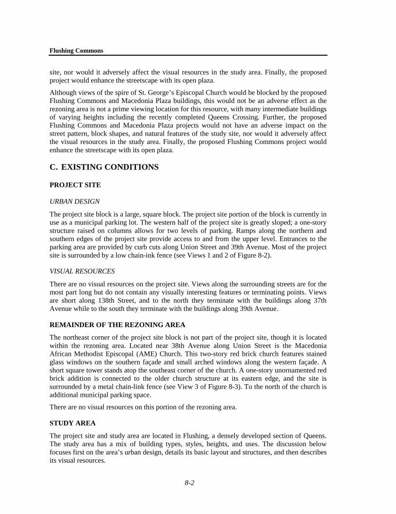
The project site block is a large, square block. The project site portion of the block is currently in use as a municipal parking lot. The western half of the project site is greatly sloped; a one-story structure raised on columns allows for two levels of parking. Ramps along the northern and southern edges of the project site provide access to and from the upper level. Entrances to the parking area are provided by curb cuts along Union Street and 39th Avenue. Most of the project site is surrounded by a low chain-ink fence (see Views 1 and 2 of Figure 8-2).
VISUAL RESOURCES
There are no visual resources on the project site. Views along the surrounding streets are for the most part long but do not contain any visually interesting features or terminating points. Views are short along 138th Street, and to the north they terminate with the buildings along 37th Avenue while to the south they terminate with the buildings along 39th Avenue.
REMAINDER OF THE REZONING AREA
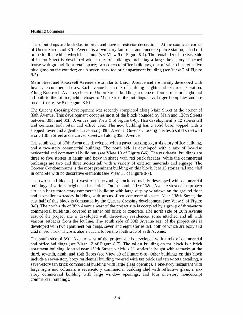
The northeast corner of the project site block is not part of the project site, though it is located within the rezoning area. Located near 38th Avenue along Union Street is the Macedonia African Methodist Episcopal (AME) Church. This two-story red brick church features stained glass windows on the southern façade and small arched windows along the western façade. A short square tower stands atop the southeast corner of the church. A one-story unornamented red brick addition is connected to the older church structure at its eastern edge, and the site is surrounded by a metal chain-link fence (see View 3 of Figure 8-3). To the north of the church is additional municipal parking space.
There are no visual resources on this portion of the rezoning area.
STUDY AREA
The project site and study area are located in Flushing, a densely developed section of Queens. The study area has a mix of building types, styles, heights, and uses. The discussion below focuses first on the area’s urban design, details its basic layout and structures, and then describes its visual resources.

Flushing Commons
1Project site, view west from Union Street
2Project site, view southwest from 37th Avenue and 138th Street
Urban Design and Visual ResourcesFigure 8-2
Project Site
4.23.07

Flushing Commons
3Remainder of rezoning block, including the Macedonia African Methodist Episcopal Church
4Union Street, view south from Northern Boulevard
Urban Design and Visual ResourcesFigure 8-3
4.23.07

Chapter 8: Urban Design and Visual Resources
8-3
URBAN DESIGN
Street Pattern, Block Shapes, and Natural Features The streets in the study area are generally straight and meet at right angles, but they are irregularly spaced, creating blocks of various sizes and shapes. The primary streets in the study area include Union Street and Main Street, which are north-south streets with two lanes of traffic running in each direction; and Roosevelt Avenue to the south, which is a major thoroughfare with one lane of traffic running in each direction. Smaller cross streets in the study area include 37th, 38th, and 39th Avenues. These avenues are narrower than the main streets and have traffic running in only one direction. 138th Street, which forms the western edge of the rezoning block, is a narrow street that extends for two blocks between 37th and 39th Avenues.
With the exception of the small blocks west of the rezoning area, the blocks in the study area are long and rectangular in shape. The two small blocks located between the rezoning block and Main Street are roughly square in shape.
The study area has a sloping topography, with Union Street sloping upward to the north and 38th and 39th Avenue sloping down to west. There are no major natural features in the study area.
Streetscape The study area is urban and mostly commercial in character and has an active and dense streetscape. The streets are paved and the sidewalks that flank them are in relatively good condition. For the most part, the buildings are attached and built to the lot line, creating continuous streetwalls. There are a few buildings in the study area that are set back from the sidewalk with parking in front. The facades of many buildings, especially along Union and Main Streets, are almost entirely covered with large, bright signs, and some have awnings that project over the sidewalks (see View 4 of Figure 8-3). The majority of the buildings are either clad in dark red brick or modern materials, such as reflective glass. The buildings in the study area range in height from one to 12 stories, creating a varied skyline.
For the most part, street furniture includes modern street lights, trash receptacles, and street signs. Along Main Street and Union Street, there are a number of “mast-arm” style lampposts. With the exception of Roosevelt Avenue, the study area has a fair number of street trees, which are mostly tall and provide shade, greenery, and a visual break to the densely developed area.
Lippmann Arcade, a narrow pedestrian walkway lined with trees, runs between Roosevelt and 39th Avenues just south of the rezoning block (see View 5 of Figure 8-4). It features seating areas, lamp posts, and planters and provides pedestrian access from the rezoning block to Roosevelt Avenue.
Building Uses, Bulk, and Arrangements The study area mostly consists of low- to mid-rise commercial buildings, some of which are mixed with residential uses. In addition, there is a police station along Union Street and a church along Main Street. With the exception of the rezoning block, the west side of Union Street within the study area is lined with three-story red brick buildings, which appear to have commercial uses on all floors and are covered in large signs. Due to the sloping topography, the buildings do not have a consistent roof line (see View 4 of Figure 8-3). The east side of Union Street is lined with a combination of three- and four-story commercial buildings and taller residential structures, all of which are built to the lot line. Along the east side of Union Street north of 37th Avenue are two large and modern apartment buildings, eight and 12 stories tall.

Flushing Commons
5Lippman Plaza
Union Street, view north from 38th Avenue 6
Urban Design and Visual ResourcesFigure 8-4
4.23.07
Flushing Commons
8-4
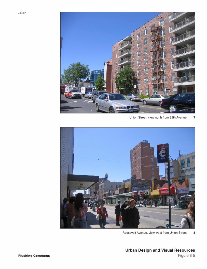
These buildings are both clad in brick and have no exterior decorations. At the southeast corner of Union Street and 37th Avenue is a two-story tan brick and concrete police station, also built to the lot line with a wheelchair ramp (see View 6 of Figure 8-4). The remainder of the east side of Union Street is developed with a mix of buildings, including a large three-story detached house with ground-floor retail space; two concrete office buildings, one of which has reflective blue glass on the exterior; and a seven-story red brick apartment building (see View 7 of Figure 8-5).
Main Street and Roosevelt Avenue are similar to Union Avenue and are mainly developed with low-scale commercial uses. Each avenue has a mix of building heights and exterior decoration. Along Roosevelt Avenue, closer to Union Street, buildings are one to four stories in height and all built to the lot line, while closer to Main Street the buildings have larger floorplates and are boxier (see View 8 of Figure 8-5).
The Queens Crossing development was recently completed along Main Street at the corner of 39th Avenue. This development occupies most of the block bounded by Main and 138th Streets between 38th and 39th Avenues (see View 9 of Figure 8-6). This development is 12 stories tall and contains both retail and office uses. The new building has a solid base, topped with a stepped tower and a gentle curve along 39th Avenue. Queens Crossing creates a solid streetwall along 138th Street and a curved streetwall along 39th Avenue.
The south side of 37th Avenue is developed with a paved parking lot, a six-story office building, and a two-story commercial building. The north side is developed with a mix of low-rise residential and commercial buildings (see View 10 of Figure 8-6). The residential buildings are three to five stories in height and boxy in shape with red brick facades, while the commercial buildings are two and three stories tall with a variety of exterior materials and signage. The Towers Condominiums is the most prominent building on this block. It is 10 stories tall and clad in concrete with no decorative elements (see View 11 of Figure 8-7).
The two small blocks just west of the rezoning block are mainly developed with commercial buildings of various heights and materials. On the south side of 38th Avenue west of the project site is a boxy three-story commercial building with large display windows on the ground floor and a smaller two-story building with ground-floor commercial space. Near 138th Street, the east half of this block is dominated by the Queens Crossing development (see View 9 of Figure 8-6). The north side of 38th Avenue west of the project site is occupied by a group of three-story commercial buildings, covered in either red brick or concrete. The north side of 38th Avenue east of the project site is developed with three-story residences, some attached and all with various setbacks from the lot line. The south side of 38th Avenue east of the project site is developed with two apartment buildings, seven and eight stories tall, both of which are boxy and clad in red brick. There is also a vacant lot on the south side of 38th Avenue.
The south side of 39th Avenue west of the project site is developed with a mix of commercial and office buildings (see View 12 of Figure 8-7). The tallest building on the block is a brick apartment building, located near 138th Street, which is 11 stories in height with setbacks at the third, seventh, ninth, and 13th floors (see View 13 of Figure 8-8). Other buildings on this block include a seven-story boxy residential building covered with tan brick and terra-cotta detailing, a seven-story tan brick commercial building with large glass openings, a one-story restaurant with large signs and columns, a seven-story commercial building clad with reflective glass, a six-story commercial building with large window openings, and four one-story nondescript commercial buildings.
Flushing Commons
7Union Street, view north from 39th Avenue
8Roosevelt Avenue, view west from Union Street
Urban Design and Visual ResourcesFigure 8-5
4.23.07

Flushing Commons
9Queens Crossing development, view west along 39th Avenue from Lippman Plaza
10View west along 37th Avenue, from Union Street
Urban Design and Visual ResourcesFigure 8-6
4.23.07
ProjectSite

Flushing Commons
1239th Avenue, view east, from 138th Street
11Towers Condominiums, view northwest from Union Street
Urban Design and Visual ResourcesFigure 8-7
4.23.07
ProjectSite

Flushing Commons
Urban Design and Visual ResourcesFigure 8-8
13South side of 39th Avenue,
view west from 138th Street
14View southwest across project site of the spire of Saint George’s Episcopal Church
4.23.07
ResidentialBuilding
QueensCrossingMacedonia
AME Church St. George’sEpiscopal
Church
Chapter 8: Urban Design and Visual Resources
8-5
VISUAL RESOURCES
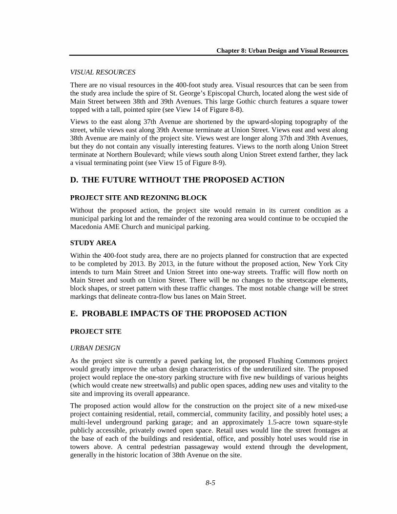
There are no visual resources in the 400-foot study area. Visual resources that can be seen from the study area include the spire of St. George’s Episcopal Church, located along the west side of Main Street between 38th and 39th Avenues. This large Gothic church features a square tower topped with a tall, pointed spire (see View 14 of Figure 8-8).
Views to the east along 37th Avenue are shortened by the upward-sloping topography of the street, while views east along 39th Avenue terminate at Union Street. Views east and west along 38th Avenue are mainly of the project site. Views west are longer along 37th and 39th Avenues, but they do not contain any visually interesting features. Views to the north along Union Street terminate at Northern Boulevard; while views south along Union Street extend farther, they lack a visual terminating point (see View 15 of Figure 8-9).
D. THE FUTURE WITHOUT THE PROPOSED ACTION
PROJECT SITE AND REZONING BLOCK
Without the proposed action, the project site would remain in its current condition as a municipal parking lot and the remainder of the rezoning area would continue to be occupied the Macedonia AME Church and municipal parking.
STUDY AREA
Within the 400-foot study area, there are no projects planned for construction that are expected to be completed by 2013. By 2013, in the future without the proposed action, New York City intends to turn Main Street and Union Street into one-way streets. Traffic will flow north on Main Street and south on Union Street. There will be no changes to the streetscape elements, block shapes, or street pattern with these traffic changes. The most notable change will be street markings that delineate contra-flow bus lanes on Main Street.
E. PROBABLE IMPACTS OF THE PROPOSED ACTION
PROJECT SITE
URBAN DESIGN
As the project site is currently a paved parking lot, the proposed Flushing Commons project would greatly improve the urban design characteristics of the underutilized site. The proposed project would replace the one-story parking structure with five new buildings of various heights (which would create new streetwalls) and public open spaces, adding new uses and vitality to the site and improving its overall appearance.
The proposed action would allow for the construction on the project site of a new mixed-use project containing residential, retail, commercial, community facility, and possibly hotel uses; a multi-level underground parking garage; and an approximately 1.5-acre town square-style publicly accessible, privately owned open space. Retail uses would line the street frontages at the base of each of the buildings and residential, office, and possibly hotel uses would rise in towers above. A central pedestrian passageway would extend through the development, generally in the historic location of 38th Avenue on the site.

Flushing Commons
Urban Design and Visual ResourcesFigure 8-9
15View south along Union Street from 39th Avenue
4.23.07
Flushing Commons
8-6
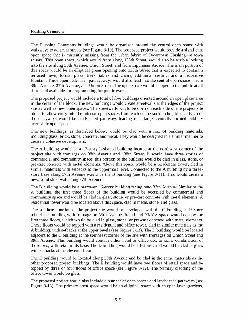
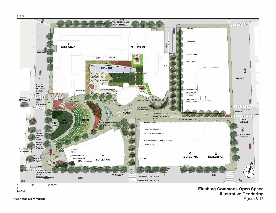
The Flushing Commons buildings would be organized around the central open space with walkways to adjacent streets (see Figure 8-10). The proposed project would provide a significant open space that is currently missing from the urban fabric of Downtown Flushing—a town square. This open space, which would front along 138th Street, would also be visible looking into the site along 38th Avenue, Union Street, and from Lippmann Arcade. The main portion of this space would be an elliptical green opening onto 138th Street that is expected to contain a terraced lawn, formal plaza, trees, tables and chairs, additional seating, and a decorative fountain. Three open pedestrian passageways would also lead into the central open space—from 39th Avenue, 37th Avenue, and Union Street. The open space would be open to the public at all times and available for programming for public events.
The proposed project would include a total of five buildings oriented around an open plaza area in the center of the block. The new buildings would create streetwalls at the edges of the project site as well as new open spaces. The streetwalls would be open on each side of the project site block to allow entry into the interior open spaces from each of the surrounding blocks. Each of the entryways would be landscaped pathways leading to a large, centrally located publicly accessible open space.
The new buildings, as described below, would be clad with a mix of building materials, including glass, brick, stone, concrete, and metal. They would be designed in a similar manner to create a cohesive development.
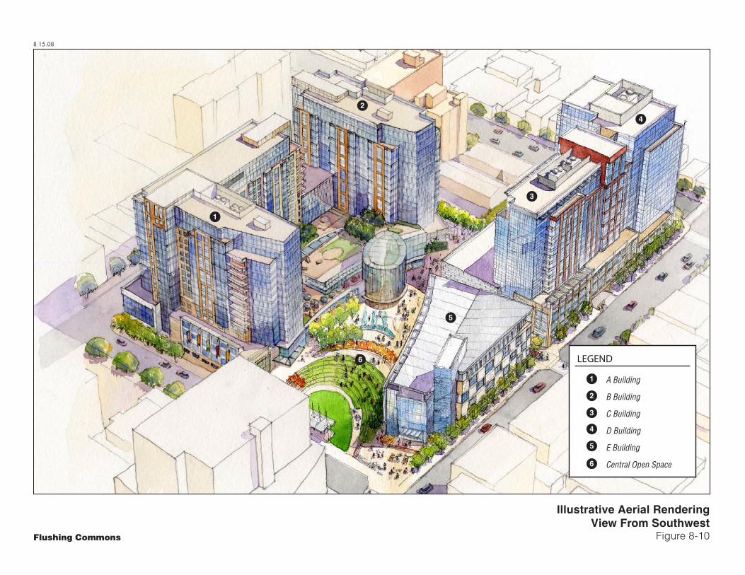
The A building would be a 17-story L-shaped building located at the northwest corner of the project site with frontages on 38th Avenue and 138th Street. It would have three stories of commercial and community space; this portion of the building would be clad in glass, stone, or pre-cast concrete with metal elements. Above this space would be a residential tower, clad in similar materials with setbacks at the uppermost level. Connected to the A building by a three-story base along 37th Avenue would be the B building (see Figure 8-11). This would create a new, solid streetwall along 37th Avenue.
The B building would be a narrower, 17-story building facing onto 37th Avenue. Similar to the A building, the first three floors of the building would be occupied by commercial and community space and would be clad in glass, stone, or pre-cast concrete with metal elements. A residential tower would be located above this space, clad in metal, stone, and glass.
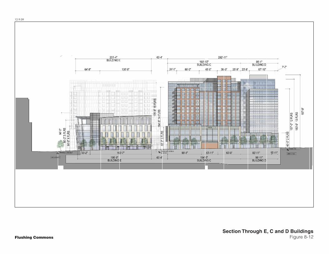
The southeast portion of the project site would be developed with the C building, a 16-story mixed use building with frontage on 39th Avenue. Retail and YMCA space would occupy the first three floors, which would be clad in glass, stone, or pre-cast concrete with metal elements. These floors would be topped with a residential and office tower, clad in similar materials as the A building, with setbacks at the upper levels (see Figure 8-12). The D building would be located adjacent to the C building at the southeast corner of the site with frontages on Union Street and 39th Avenue. This building would contain either hotel or office use, or some combination of those two, with retail in its base. The D building would be 13-stories and would be clad in glass with setbacks at the eleventh floor.
The E building would be located along 39th Avenue and be clad in the same materials as the other proposed project buildings. The E building would have two floors of retail space and be topped by three or four floors of office space (see Figure 8-12). The primary cladding of the office tower would be glass.
The proposed project would also include a number of open spaces and landscaped pathways (see Figure 8-13). The primary open space would be an elliptical space with an open lawn, gardens,
8.15.08
Illustrative Aerial RenderingView From Southwest
Figure 8-10Flushing Commons
1
2
3
5
6
4
A Building
B Building
C Building
D Building
E Building
Central Open Space
1
2
3
4
5
6
LEGEND
12.9.09
Section Through A and B BuildingsFigure 8-11Flushing Commons
12.9.09
Section Through E, C and D BuildingsFigure 8-12Flushing Commons
9.12.08
SCALE
0 40 80 FEET
Flushing Commons
N
Flushing Commons Open SpaceIllustrative Rendering
Figure 8-13

Chapter 8: Urban Design and Visual Resources
8-7
trees, and a water feature, generally in the center of the development. All of the landscaped pathways would connect this central open space to the surrounding sidewalks. From the central open space, three open pedestrian passageways would also lead into the central open space—from 39th Avenue, 37th Avenue, and Union Street. These landscaped spaces would also provide a visual buffer between the Macedonia AME Church and the proposed project. The pedestrian passageways would provide a landscaped transition area between the project site and the surrounding area and visually separate the taller buildings and the low-scale church.
VISUAL RESOURCES
The incremental height that would be provided by the Board of Standards and Appeals special permit would also not have an impact on surrounding visual resources. Therefore, the proposed development would not substantially affect the visual enjoyment of visual resources.
REMAINDER OF THE REZONING AREA
As described in Chapter 1, “Project Description,” the remainder of the rezoning area would be developed as the Macedonia Plaza project, a mixed-use building that would include residential units, community facility and retail space.1
As a result of the proposed rezoning, development on this site would greatly alter the urban design of the site by replacing the paved parking area with a new, modern development. It would create new streetwalls and bring development and new open space to an underutilized lot. The development also would notably change the appearance of the northeast corner of the project block; however, the uses, size, and massing of the proposed building would be consistent with that of the Flushing Commons development. The expected materials of the Macedonia Plaza structure—primarily brick and glass—would be consistent with the façade materials of the Macedonia AME Church itself.
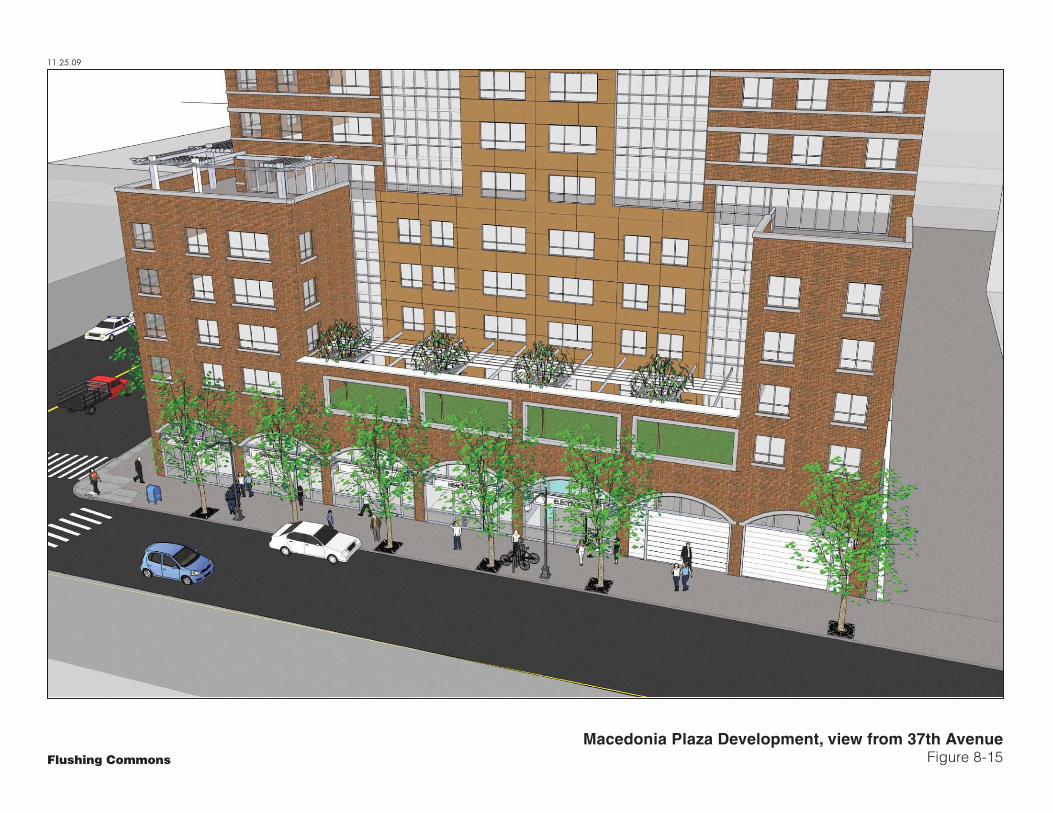
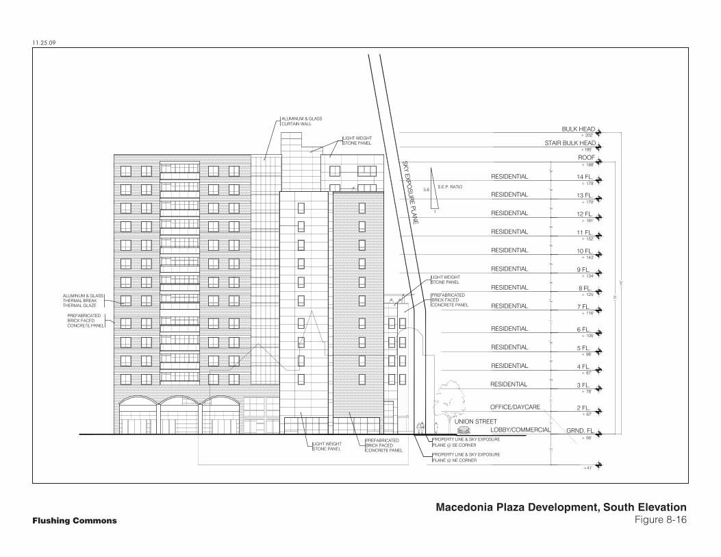
The proposed building would be directly adjacent to the Macedonia AME Church, and at 14 stories (132 feet) it would create a notable new presence at the corner of Union Street and 37th Avenue (see Figures 8-14 through 8-16). The proposed building would maintain a streetwall along 37th Avenue, which will set back at the center of the third floor at a height of approximately 31 feet, and at the sixth floor at the two ends at a height of approximately 60 feet, above which it will set back by 20 feet from the streetline before reaching its maximum height. Similarly, the streetwall along Union Street will rise up to six stories at approximately 60 feet, above which it will set back by 12 feet from the streetline, before reaching the building’s maximum height. The anticipated cladding materials for the building are brick and glass. The Macedonia Plaza project also would provide approximately 18,834 square feet of gated open space in the interior of the lot, and new street trees would be planted along 37th Avenue and Union Street.
As described in Chapter 1, the rezoning itself is not expected to result in redevelopment of the Macedonia AME Church site, and the church would remain in its current location.
1 Although there are future plans to expand and/or renovate the Macedonia AME Church site, these plans
and any associated actions, are not included in the proposed action and therefore not included in this EIS.

12.1.09
Macedonia Plaza Development, First Floor PlanFigure 8-14Flushing Commons
11.25.09
Macedonia Plaza Development, view from 37th AvenueFigure 8-15Flushing Commons
11.25.09
Macedonia Plaza Development, South ElevationFigure 8-16Flushing Commons

Flushing Commons
8-8
STUDY AREA
URBAN DESIGN
Street Pattern, Block Shapes, and Natural Features The proposed action would be located on an existing block and would not alter the street pattern, block shapes, or natural features in the study area. Therefore, the new buildings would not have an adverse impact on these urban design features.
Streetscape The proposed buildings would be built to the lot lines, thereby extending existing streetwalls. Other streetscape elements—such as lamp posts and signage—would not be altered by the proposed development. The proposed buildings would improve the current underutilization of the project site by creating street life and activity through ground-floor commercial spaces, including stores, restaurants, and cafes. In addition, the residential and commercial uses would increase pedestrian traffic and improve the overall appearance of the study area. The open plaza and green spaces would further improve the streetscape of the study area and provide a visual break in the density of the area.
Building Uses, Bulk, and Arrangements The residential, commercial, and office uses of the proposed buildings would be consistent with the predominant uses in the study area. There is a wide variety of building styles and materials used in the area; thus, the design of the buildings and mix of materials would be in keeping with what is currently found in the study area. While the new buildings would be taller and have larger footprints than some of the buildings in the surrounding area, they would be in keeping with other large-scale developments in the area, including the Queens Crossing development and the condominium building to the south of the site.
VISUAL RESOURCES
The proposed buildings would be taller than existing buildings in the immediate study area. However, the proposed buildings would not block any important view corridors or block any significant views to any visual resources. St. George’s Episcopal Church would still be visible from Main Street, its primary viewing location. Therefore, the proposed project is not expected to have any adverse impacts on visual resources within the study area.