CHAPTER 7–Implementation of the Proposed Action, the Draft CCP€¦ · Native Grassland Objective...
47
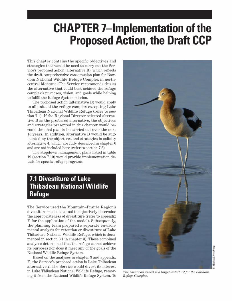
CHAPTER 7–Implementation of the Proposed Action, the Draft CCP The American avocet is a target waterbird for the Bowdoin Refuge Complex. © Michael Forsberg This chapter contains the specific objectives and strategies that would be used to carry out the Ser- vice’s proposed action (alternative B), which reflects the draft comprehensive conservation plan for Bow- doin National Wildlife Refuge Complex in north- central Montana. The Service recommends this as the alternative that could best achieve the refuge complex’s purposes, vision, and goals while helping to fulfill the Refuge System mission. The proposed action (alternative B) would apply to all units of the refuge complex excepting Lake Thibadeau National Wildlife Refuge (refer to sec- tion 7.1). If the Regional Director selected alterna- tive B as the preferred alternative, the objectives and strategies presented in this chapter would be- come the final plan to be carried out over the next 15 years. In addition, alternative B would be aug- mented by the objectives and strategies in salinity alternative 4, which are fully described in chapter 6 and are not included here (refer to section 7.2). The stepdown management plans listed in table 19 (section 7.10) would provide implementation de- tails for specific refuge programs. 7.1 Divestiture of Lake Thibadeau National Wildlife Refuge The Service used the Mountain–Prairie Region’s divestiture model as a tool to objectively determine the appropriateness of divestiture (refer to appendix E for the application of the model). Subsequently, the planning team prepared a separate environ- mental analysis for retention or divestiture of Lake Thibadeau National Wildlife Refuge, which is docu- mented in section 3.1 in chapter 3). These combined analyses determined that the refuge cannot achieve its purposes nor does it meet any of the goals of the National Wildlife Refuge System. Based on the analyses in chapter 3 and appendix E, the Service’s proposed action is Lake Thibadeau alternative 2. The Service would divest its interest in Lake Thibadeau National Wildlife Refuge, remov- ing it from the National Wildlife Refuge System. To
Transcript of CHAPTER 7–Implementation of the Proposed Action, the Draft CCP€¦ · Native Grassland Objective...
CHAPTER 7–Implementation of the Proposed Action, the Draft CCP
The American avocet is a target waterbird for the Bowdoin Refuge Complex.
© M
icha
el F
orsb
erg
This chapter contains the specific objectives and strategies that would be used to carry out the Ser-vice’s proposed action (alternative B), which reflects the draft comprehensive conservation plan for Bow-doin National Wildlife Refuge Complex in north-central Montana. The Service recommends this as the alternative that could best achieve the refuge complex’s purposes, vision, and goals while helping to fulfill the Refuge System mission.
The proposed action (alternative B) would apply to all units of the refuge complex excepting Lake Thibadeau National Wildlife Refuge (refer to sec-tion 7.1). If the Regional Director selected alterna-tive B as the preferred alternative, the objectives and strategies presented in this chapter would be-come the final plan to be carried out over the next 15 years. In addition, alternative B would be aug-mented by the objectives and strategies in salinity alternative 4, which are fully described in chapter 6 and are not included here (refer to section 7.2).
The stepdown management plans listed in table 19 (section 7.10) would provide implementation de-tails for specific refuge programs.
7.1 Divestiture of Lake Thibadeau National Wildlife Refuge
The Service used the Mountain–Prairie Region’s divestiture model as a tool to objectively determine the appropriateness of divestiture (refer to appendix E for the application of the model). Subsequently, the planning team prepared a separate environ-mental analysis for retention or divestiture of Lake Thibadeau National Wildlife Refuge, which is docu-mented in section 3.1 in chapter 3). These combined analyses determined that the refuge cannot achieve its purposes nor does it meet any of the goals of the National Wildlife Refuge System.
Based on the analyses in chapter 3 and appendix E, the Service’s proposed action is Lake Thibadeau alternative 2. The Service would divest its interest in Lake Thibadeau National Wildlife Refuge, remov-ing it from the National Wildlife Refuge System. To

216 Draft CCP and EA, Bowdoin National Wildlife Refuge Complex, Montana
carry out this alternative, the Service would do the following:
■■ Prepare the final divestiture proposal, through coordination of the refuge staff with the Moun-tain–Prairie Region’s Division of Realty, Division of Refuge Planning, and regional archaeologist.
■■ Voluntarily relinquish all refuge easements and return all rights to the landowner.
■■ Transfer to the landowner the dams, spillways, and water control structures, or remove them.
■■ Voluntarily relinquish the refuge water rights to the State of Montana.
■■ Complete the divestiture within 5 years of CCP approval.
The divestiture of Lake Thibadeau National Wildlife Refuge would require an act of Congress.
Refuge staff record data about vegetation to measure conditions and response to management actions.
US
FW
S
7.2 Salinity and Blowing SaltsChapter 6 contains a separate environmental anal-ysis that addresses the salinity and blowing salts problem at Bowdoin Refuge.
Lake Bowdoin is a subsaline waterbody with a rising salinity level. At certain salinity concentra-tions, desirable plants and animals cannot survive and are excluded from the ecosystem. Another prob-lematic aspect is the dissolved salts in Dry Lake, which are carried by wind and deposited on private lands, with potentially negative effects on soils, crops, livestock, and human health.
To accomplish refuge objectives, the Service needs to reduce salinity levels and restore fresher conditions in Lake Bowdoin. Based on the analysis in chapter 6, the Service has identified salinity alterna-tive 4 as the proposed action, comprising the follow-ing major actions:
■■ Develop an injection well to force saline water from Lake Bowdoin deep into the ground.
217CHAPTER 7–Implementation of the Proposed Action, the Draft CCP
■■ Operate Lake Bowdoin to maximize the effects of natural flooding by allowing Beaver Creek flood-waters to flush the lake.
■■ Manage operations to meet the salinity objective of 7,000 mg/L of salts in Lake Bowdoin.
■■ Evaluate the lake’s infrastructure to determine the best way to re-create a flow-through water system that would maximize the flushing effects of natural flooding.
7.3 Summary of the Draft CCPThe rest of this chapter contains the draft CCP—the objectives and strategies for the remaining resources and programs in the refuge complex as identified in alternative B, the proposed action (refer to section 3.3 in chapter 3).
The focus of the draft CCP, as described in alter-native B, is to carry out science-based management of native mixed-grass prairie and associated wildlife along with complementary visitor services:
■■ The Service would use the best available science and research to determine the most effective methods for protecting, restoring, and enhanc-ing native mixed-grass prairie to provide quality nesting habitat for targeted grassland-dependent birds. Invasive and nonnative plants, particu-larly Russian olive trees that fragment grass-land habitat, would be controlled, reduced, or eliminated and areas restored to native plants. Enhanced wetlands would be managed to mimic natural conditions for target species of wetland-dependent migratory birds during spring and fall migrations and during the breeding and nesting season.
■■ The Service would provide more waterfowl sanc-tuary area on the eastern half of the refuge by closing a portion of the refuge to all foot traf-fic until migrating waterfowl depart, no sooner than December 1. This would not affect current waterfowl-hunting areas. The remaining wildlife-dependent public uses would be maintained or improved including the environmental education and interpretation programs. The Service would work with the State to determine the feasibility of offering a compatible, big game archery hunt on Bowdoin Refuge. The current visitor contact area would be expanded and a visitor services specialist would be added to the staff.
■■ All programs would provide visitors with infor-mation on the purposes of the refuge complex including the protection of migratory birds, the importance of protecting the remaining native mixed-grass prairie, and the mission of the Na-tional Wildlife Refuge System.
■■ Increased research and monitoring, staff, fund-ing, infrastructure, and partnerships would be required to accomplish the goals, objectives, and strategies outlined in this chapter.
Sections 7.4–7.9 set out the objectives and strate-gies that serve as the steps needed to achieve the CCP goals for the remaining four refuges (not in-cluding Lake Thibadeau Refuge) and Bowdoin Wet-land Management District. While a goal is a broad statement, an objective is a concise statement that indicates what is to be achieved, the extent of the achievement, who is responsible, and when and where the objective should be achieved—all to ad-dress the goal. The strategies are the actions needed to achieve each objective. Unless otherwise stated, the refuge complex staff would carry out the actions in the objectives and strategies. The rationale for each objective provides context such as background information, assumptions, and technical details.
Appendix D contains the required compatibility determinations (draft) for public and management uses associated with this draft CCP.
7.4 Goal for Upland Habitat and Associated Wildlife
Protect, enhance, and restore grassland habitat for breeding and migratory birds and other wildlife while maintaining the biologi-cal diversity and integrity of native prairie grasslands.
Native GrasslandPrairie ecosystems thrive on the intermittent dis-turbance brought by frequent fire and the irregu-lar mosaic of vegetation carved out by insects and native grazers, especially the periodic passage of bison. These disturbances and subsequent renewal have shaped the life cycle of every native prairie organism. More than 150 years ago, bison were re-placed with cattle, which grazed differently and did not migrate. Historically, continuous cattle grazing

218 Draft CCP and EA, Bowdoin National Wildlife Refuge Complex, Montana
was allowed on the refuge complex until the mid-1970s. This, combined with a lack of fire for at least 70 years, has resulted in a loss of plant structure and species diversity, both of which are necessary for a healthy and productive grassland ecosystem. The more palatable, tall, cool-season grasses such as green needlegrass and bluebunch wheatgrass have been replaced by increasers such as blue grama, fringed sagewort, and clubmoss. While these plants are an important part of native prairie, they should be components of a more diverse community (Lacey et al. 2005). The loss of variety in plant species and structure can be detrimental to grassland-dependent birds, which require a variety of habitats for nesting and foraging.
Today, cattle grazing can be a valuable tool in the absence of bison. If applied or used properly, grazing of native prairie by cattle can be used to stimulate vegetative and reproductive growth of plants. How-ever, it is important that it be closely monitored and follow a prescription to achieve a habitat objective.
Grassland-nesting birds are one of the most rap-idly declining groups of wildlife in North America, primarily due to habitat loss (Peterjohn et al. 1999). The Service has selected six target species of upland birds; these species depend on native prairie habi-tat and are listed as species of concern by Federal, State, and private entities (table 13). The upland habitat objectives, for both native and disturbed grasslands, focus on providing quality habitats (table 14) for these target species. The resulting habitats should benefit a much broader group of secondary
bird species as well as a variety of other wildlife, both migratory and resident. This includes several of the target species of waterbirds (refer to section 7.5).
Table 13. Conservation status of target species of upland birds at Bowdoin National Wildlife Refuge Complex, Montana.U.S. Fish and National Montana species Partners in Bureau of Land Species Wildlife Service Audubon 1 3 4of concern Flight priority Management 2focal species Watch List
5
Baird’s sparrow
Sprague’s pipit
Chestnut-collared longspur
Greater sage-grouse
Long-billed curlew
Marbled godwit
S2
S2
S3
S3
S2
—
√
Candidate
√
Candidate
√
√
1
1
2
1
2
2
Sensitive
Sensitive
Sensitive
Sensitive
Sensitive
Sensitive
Red
Yellow
Yellow
Yellow
Yellow
Yellow
1 S2=At risk because of very limited and potentially declining numbers, extent, or habitat, making it vulnerable to global extinction or extirpation in the State. S3=Potentially at risk because of limited and potentially declining num-bers, extent, or habitat, even though it may be abundant in some areas. (Montana Fish, Wildlife & Parks; Montana Natural Heritage Program)2 Candidate=A species under consideration for official listing, for which there is sufficient information to support listing.3 1=Needs conservation action. 2=Needs monitoring.4 Sensitive=Proven to be imperiled in at least part of its range and documented to occur on Bureau of Land Manage-ment lands.5 Red=Declining rapidly or having very small populations or limited ranges and facing major conservation threats; typically of global conservation concern. Yellow=Declining or rare; typically of national conservation concern.
Native Grassland Objective 1Over the next 50 years or more, manage for native grassland plant species composition that approxi-mates the historical plant community consisting of (1) 80–90 percent grasses and grass-like plants in-cluding green needlegrass, bluebunch wheatgrass, and western wheatgrass, (2) 8–12 percent forbs such as American vetch, dotted gayfeather, purple prairie clover, and other native forbs, and (3) 4–6 percent shrubs such as winterfat, silver sagebrush, and rub-ber rabbitbrush.
Strategies
■■ Complete a baseline inventory of native grass-lands in the refuge complex to determine abun-dance and overall health of grasses, forbs, and shrubs including whether remnants of the histor-ical climax plant community exist and can serve as a seed source for restoration efforts.
■■ Determine if native ungulates are overbrowsing forbs and shrubs.
■■ Determine priority areas for restoration using the baseline inventory.

219CHAPTER 7–Implementation of the Proposed Action, the Draft CCP
■■ Develop a grassland habitat management plan that incorporates tested methods for preserving and enhancing native grassland.
■■ Use a variety of management techniques such as prescribed burning, prescriptive grazing, and “in-terseeding.” Use care with prescribed fire in this arid climate—to determine if and when an area should be burned, consider weather patterns (for example, annual rainfall since an area was last burned), vegetation, plant diversity, and current use by target bird species.
■■ Plant silver sagebrush on the Korsbeck and Bea-ver Creek WPAs to provide additional breeding, nesting, and feeding habitat for greater sage-grouse.
■■ To determine the effectiveness of management techniques, use a scientifically credible and conservative adaptive management monitor-ing scheme including evaluating the response of target upland bird species. Use this adaptive management approach to determine if the most effective methods and technologies are being used to achieve this objective.
■■ Collaborate with the Bureau of Land Manage-ment to monitor the prairie dog town on Hewitt Lake National Wildlife Refuge to ensure that it is maintained. Possibly pursue an agreement to close the entire prairie dog town to shooting year-round.
■■ Use habitat evaluations on Bowdoin Refuge to determine potential effects (and their degree) of native big game grazers such as white-tailed deer
and pronghorn overbrowsing desirable native plant species, which would affect both species diversity and structure.
Table 14. Nesting habitat requirements for target species of upland birds at Bowdoin National Wildlife Refuge Complex, Montana.
Species Vegetation height(inches)
Litter depth 1
(inches)Shrub cover
(percent)Area
sensitive 2
Use of nonnative vegetation
Baird’s sparrow 8.3–13.4 1.6–8.3 <25 Yes Low
Sprague’s pipit 10–12.5 0.8–4.3 5–20 Yes Low
Chestnut-collared long-spur
5.9–11.8 <2.5 <25 Yes Low
Greater sage-grouse >5.9 — 15–31 Yes —
Long-billed curlew 2.5–11 — 0 Yes Some
Marbled godwit 5.9–11.8 0.8–3.5 — Yes Low
1 (—)=No data found.2 Area sensitive=Species are more abundant or occur more frequently in larger patches of mixed-grass prairie; size of the area varies with the species.Sources: Davis (2004), Dechant et al. (2003), Dieni and Jones (2003), Green et al. (2002), Jones (2010), MSGWG (2005).
Silver Sagebrush
Gar
y A
. Mon
roe
/ US
DA
–NR
CS
PL
AN
TS
Dat
abas
e
Rationale. Restoration of the historical plant com-munity in the uplands would be a long-term proj-ect that goes well beyond the 15-year scope of the CCP. Ideally, upland habitats in the refuge complex would consist, over time, of grassland that provides a diversity of native vegetation and a mosaic of veg-etative structure across a broad landscape. This mosaic of vegetation communities supports a greater diversity of grassland birds (Fuhlendorf et al. 2006, Madden et al. 2000) and other wildlife; however, whatever treatments are used for restoration must take into account the dry climate and the needs of the target bird species. The fact that many of the

220 Draft CCP and EA, Bowdoin National Wildlife Refuge Complex, Montana
target birds are present and nesting on uplands in the refuge complex indicates that these areas are already providing some habitat for these species. Using both monitoring and adaptive management would be important before choosing where, how, and when to enhance the vegetative and structural diversity of an area.
The Society for Ecological Restoration defines ecological restoration as “the process of assisting the recovery of an ecosystem that has been degraded, damaged or destroyed” (Society for Ecological Restoration International 2004). As stated in their International Primer on Ecological Restoration, ecosystems may be altered “to the point at which the ecosystem cannot recover its predisturbance state or its historical developmental trajectory. Res-toration attempts to return an ecosystem to its his-toric trajectory.” It is not known how far the refuge complex would get along the restoration trajectory over the 15 years of the CCP; but once there was a baseline inventory, the Service could at least track that uplands were moving toward the ideal plant community and structure described in this objective.
A reference ecosystem that serves as a model is necessary to design restoration. Historical con-ditions are a good starting point for restoration design. The conditions described in this objective are based on the USDA (U.S. Department of Agri-culture)–Natural Resource Conservation Service’s ecological site description for the silty 10- to 14-inch precipitation zone (Lacey et al. 2005). Ecological site descriptions are based on “relic areas and other ar-eas protected from excessive disturbance,” illustrat-ing the historical climax plant community as further described below (Natural Resources Conservation Service 2003):
The historic climax plant community for a site in North America is the plant community that existed at the time of European immi-gration and settlement. It is the plant com-munity that was best adapted to the unique combination of environmental factors associ-ated with the site […] Natural disturbances, such as drought, fire, grazing of native fauna, and insects, were inherent in the development and maintenance of these plant communities […] Plant communities that are subjected to abnormal disturbances and physical site dete-rioration or that are protected from natural influences, such as fire, for long periods, sel-dom typify the historic climax vegetation and may exist in a steady state that is different from the historic climax plant community. The historic climax plant community of an ecological site is not a precise assemblage of
species for which the proportions are the same from place to place or from year to year.
The ecological site description describes the grass, forb, and shrub species that compose the historical climax plant community and how the site may be affected by management actions such as lack of fire and overgrazing and environmental conditions such as prolonged drought. According to the ecological site description, most of the native uplands in the refuge complex are classified as “Plant Community C,” which is characterized by a loss of tall bunch-grasses (green needlegrass, bluebunch wheatgrass, and porcupine grass) and an overabundance of club-moss, blue grama, and prairie Junegrass.
Bowdoin Refuge may support as many as 300 white-tailed deer and pronghorn. Pronghorn graze some portions of the refuge year-round. While the full effect of this constant grazing is unknown, ob-servations of sentinel forbs and shrub species on portions of the refuge show signs of severe over-grazing (Bob Skinner, wildlife biologist, U.S. Fish and Wildlife Service, Lewistown, Montana; personal communication, March 2007). Sentinel species are those species of desirable native plants that are of-ten overbrowsed. These grazers, although native, can have detrimental effects on species diversity and structure due to their plant preferences. The Service would need to determine the severity of the grazing and, if necessary, determine how to better distribute and reduce herd sizes.
Clubmoss
M.C
. Ste
nsvo
ld /
US
DA
–NR
CS
PL
AN
TS
Dat
abas
e
Native Grassland Objective 2Within 3 years, use various treatment methods to determine the most effective technique for treating and restoring refuge uplands that have become un-naturally dominated (greater than 30-percent cover) by clubmoss.
221CHAPTER 7–Implementation of the Proposed Action, the Draft CCP
Strategies
■■ Thoroughly research clubmoss effects and other studies dealing with clubmoss.
■■ Network with other agencies and universities that are dealing with clubmoss such as Natural Resources Conservation Service, The Nature Conservancy, and Montana State University.
■■ Recruit graduate students to carry out clubmoss studies on the refuge complex.
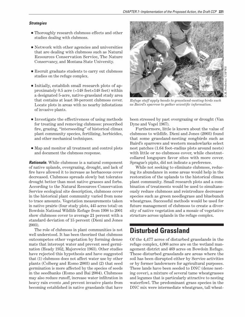
■■ Initially, establish small research plots of ap-proximately 0.5 acre (=148 feet×148 feet) within a designated 5-acre, native-grassland study area that contains at least 30-percent clubmoss cover. Locate plots in areas with no nearby infestations of invasive plants.
■■ Investigate the effectiveness of using methods for treating and removing clubmoss: prescribed fire, grazing, “interseeding” of historical climax plant community species, fertilizing, herbicides, and other mechanical techniques.
■■ Map and monitor all treatment and control plots and document the clubmoss response.
Rationale. While clubmoss is a natural component of native uplands, overgrazing, drought, and lack of fire have allowed it to increase as herbaceous cover decreased. Clubmoss spreads slowly but tolerates drought better than most native grasses and forbs. According to the Natural Resources Conservation Service ecological site description, clubmoss cover in the historical plant community varied from none to trace amounts. Vegetation measurements taken in native prairie (four study plots, 445 acres total) on Bowdoin National Wildlife Refuge from 1998 to 2001 show clubmoss cover to average 21 percent with a standard deviation of 15 percent (Dieni and Jones 2003).
The role of clubmoss in plant communities is not well understood. It has been theorized that clubmoss outcompetes other vegetation by forming dense mats that intercept water and prevent seed germi-nation (Heady 1952, Majorowicz 1963). Other studies have rejected this hypothesis and have suggested that (1) clubmoss does not affect water use by other plants (Colberg and Romo 2003) and (2) that seed germination is more affected by the species of seeds in the seedbanks (Romo and Bai 2004). Clubmoss may also reduce runoff, increase water infiltration in heavy rain events ,and prevent invasive plants from becoming established in native grasslands that have
been stressed by past overgrazing or drought (Van Dyne and Vogel 1967).
Furthermore, little is known about the value of clubmoss to wildlife. Dieni and Jones (2003) found that some grassland-nesting songbirds such as Baird’s sparrows and western meadowlarks select nest patches (1.64 foot–radius plots around nests) with little or no clubmoss cover, while chestnut-collared longspurs favor sites with more cover. Sprague’s pipits, did not indicate a preference.
While not seeking to eliminate clubmoss, reduc-ing its abundance in some areas would help in the restoration of the uplands to the historical climax plant community. Small research plots and a com-bination of treatments would be used to simultane-ously reduce clubmoss and reintroduce decreaser species such as green needlegrass and bluebunch wheatgrass. Successful methods would be used for future management of clubmoss to create a diver-sity of native vegetation and a mosaic of vegetative structure across uplands in the refuge complex.
Refuge staff apply bands to grassland-nesting birds such as Baird’s sparrow to gather scientific information.
D.M
. Pre
llwit
z / U
SF
WS
Disturbed GrasslandOf the 4,477 acres of disturbed grasslands in the refuge complex, 4,008 acres are on the wetland man-agement district and 469 acres on Bowdoin Refuge. These disturbed grasslands are areas where the soil has been disrupted either by Service activities or by former landowners for agricultural purposes. These lands have been seeded to DNC (dense nest-ing cover), a mixture of several tame wheatgrasses and legumes that is particularly attractive to nesting waterfowl. The predominant grass species in the DNC mix were intermediate wheatgrass, tall wheat-
222 Draft CCP and EA, Bowdoin National Wildlife Refuge Complex, Montana
grass, slender wheatgrass, pubescent wheatgrass, and western wheatgrass; the legumes were alfalfa and sweetclover.
Many of the DNC fields in the refuge complex are in poor condition with respect to plant diversity. These fields have only two to three of the originally planted species remaining and in many cases are dominated by exotic cool-season grasses (for ex-ample, crested wheatgrass and cheatgrass). Proper management of DNC is very intensive. A successful planting may provide quality habitat up to 8 years without disturbance; however, it is the periodic vegetation treatments such as burning and haying that capitalize on the relationship between young, vigorous stands of vegetation and higher wildlife production (Duebbert et al. 1981). With a rotational management plan that periodically rejuvenates the stand, the lifespan of a DNC seeding is about 15 years (Higgins and Barker 1982, Lokemoen 1984). Most of the refuge complex’s DNC fields are well past this 15-year period.
Due to the intensive management requirements and the limited lifespan of DNC plantings—com-bined with recent studies indicating minimal benefits to grassland-nesting birds in DNC plantings in areas with an abundance of perennial cover (Arnold et al. 2007)—the refuge complex would gradually work to reseed the disturbed grasslands to native vegeta-tion.
Disturbed Grassland Objective 1Over the next 15 years, reseed at least 500 acres to native herbaceous mixtures on areas that have become decadent and overrun by nonnative, cool-season grasses to comprise more than 60-percent na-tive grasses and forbs within 10 years after seeding.
Strategies
■■ Use the Natural Resources Conservation Ser-vice’s ecological site descriptions, based on soil type, to determine characteristic vegetation com-position for each site.
■■ Use locally collected seeds for planting to main-tain the genetic strain of native plants found in the area, based on availability and cost.
■■ Use appropriate techniques for site preparation to ensure weed-free seedbeds.
■■ Use farming activities to prepare appropriate seedbeds.
■■ Manage habitat using tools such as prescribed fire and prescriptive grazing, haying, and resting.
■■ Use integrated pest management strategies to reduce invasive plants including noxious weeds.
■■ Use the best available science and updated tech-niques for restoration and monitoring response.
■■ Work with universities and other partners to pursue graduate student and research projects that would address specific management chal-lenges for restoring and managing disturbed grasslands including controlling clubmoss and crested wheatgrass.
■■ Monitor the response of target species of upland birds before and after treatment to determine the success of management techniques, and use adaptive management to ensure the refuge com-plex is using the most effective methods and new technologies.
■■ In restored areas, continue to trap mammalian predators such as raccoons and skunks (1) to de-crease predation on ground-nesting migratory birds and their nests and (2) to protect birds that have been live-trapped for banding or disease detection. Continue to use only live traps in these situations to ensure that only targeted predator species are removed from the area (use no leg hold traps).
Rationale. Using appropriate management tech-niques to emulate the natural disturbances under which native prairie plants evolved, the native plant seeding should persist in perpetuity. The native plantings would reduce habitat fragmentation and attract grassland birds that have adapted to the diverse structure of native prairie; whereas DNC would limit the structural diversity of the vegetation and likely attract those bird species that key into tall dense cover. Native grass, although more difficult to establish and usually more expensive, can be main-tained in a vigorous condition longer without the need for constant rejuvenation.
Disturbed Grassland Objective 2Over the next 15 years, continue to use and maintain DNC on disturbed grasslands for wildlife habitat; maintain DNC every 4–7 years to promote the opti-mal vigor of present plant species.
223CHAPTER 7–Implementation of the Proposed Action, the Draft CCP
Strategies
■■ Use appropriate techniques for site preparation to ensure weed-free seedbeds.
■■ Use farming activities to prepare appropriate seedbeds.
■■ Seed DNC on highly erodible lands in Bowdoin Wetland Management District.
■■ Manage habitat using tools such as prescribed fire and prescriptive cattle grazing and haying to establish and maintain DNC.
■■ Use integrated pest management strategies to reduce noxious weeds and other invasive plants.
Rationale. Disturbed grasslands that have not been targeted for native plantings would be maintained in their current state of cover, and periodic treatment would remove accumulated duff and rejuvenate plants. Vegetative cover including DNC plantings older than 15 years would be managed to maintain their vigor, so these areas could continue to provide value to wildlife and increased soil stabilization for reduced sedimentation into wetlands.
Some areas might be reseeded to DNC if needed to maintain structure and productivity. Fields domi-nated by exotic cool-season grasses such as crested wheatgrass and cheatgrass might become source sites from which these exotic grasses could invade adjoining grasslands. In these situations, it might be more appropriate due to funding availability to plant DNC rather than a native grass mixture. In those seed mixes, viable grasses would be western wheatgrass, slender wheatgrass, and tall wheat-grass, and alfalfa would be a compatible legume. On highly erodible land that has lost its topsoil layer due to years of farming, planted DNC could reduce erosion and initiate the redevelopment of a topsoil layer for future native seed establishment.
The sora is a small marsh bird that uses ponds in the Bowdoin Refuge Complex.
Dav
e M
enke
/ U
SF
WS
7.5 Goal for Wetland Habitat and Associated Wildlife
Provide wetland habitat for breeding and migratory birds and other wildlife that main-tains biological diversity and integrity of prairie pothole wetlands.
Wetlands in the Bowdoin National Wildlife Refuge Complex are a mixture of managed and natural wet-lands of different types, sizes, and water quality.
Managed wetlands are areas created or restored through water management, such as using water control structures to manually flood areas and to conduct water drawdowns. The focus for managed wetlands is to mimic natural wetland conditions whenever possible.
Temporary, seasonal, and semipermanent wetlands are by far the most important types of wetlands for most species of waterfowl that breed throughout the Prairie Pothole Region (Kantrud et al. 1989). Waterfowl, shorebirds, and other water-birds depend on this complex of wetland types to fulfill various needs throughout their life history, particularly during the breeding season (Baldasarre and Bolen 2006). For example, during a radio-te-lemetry study of mallards nesting North Dakota, eight females used 7–22 different wetlands during the breeding period; the birds preferred temporary, seasonal, and, to a lesser extent, semipermanent wetlands (Dwyer et al. 1979).
By understanding how waterfowl and other waterbirds use resources, managers are able to at-tract and hold these species on managed wetlands. Manipulation of soil and water to produce essential habitat structure or foods may be necessary. The sharp increase in invertebrate populations when wetlands flood following a dry phase is an important reason for artificially flooding and draining wetlands to enhance waterfowl habitat (Cook and Powers 1958, Kadlec and Smith 1992), and it is the basis for the modern-day practice of moist-soil management (Fredrickson and Taylor 1982).
To promote seed-producing wetland plants for fall migrants like waterfowl, it is important to know the regional growing seasons. Managers can use this information to schedule gradual drawdowns of man-aged wetlands to achieve the most productive plant response. Plant promotion is also good structure for production and diversity of invertebrates. The

224 Draft CCP and EA, Bowdoin National Wildlife Refuge Complex, Montana
average length of the growing season in Phillips County, Montana, is 130 days (PhillCo Economic Growth Council, Inc. 2001). Where the growing sea-son is shorter than 140 days, wetland drawdowns are described as early or late drawdowns. Early drawdowns are those that occur during the first 45 days of the growing season, whereas late draw-downs occur in the latter 90 days of the growing season (Fredrickson 1991). In areas characterized by summer droughts, early drawdowns often result in good germination and newly established plants have time to establish adequate root systems before dry summer weather predominates. For example, smartweed tends to respond best to early draw-downs, whereas sprangletop responds best to late drawdowns. Drawdowns can be natural or mechani-cal (by means of water control structures).
Drawdowns attract a diversity of foraging birds such as shorebirds and white-faced ibis to wetlands with abundant food resources, concentrated in smaller areas and at different water depths (Fred-rickson 1991). Slow drawdowns (2–3 weeks) are usually more desirable for plant establishment and wildlife use. Slow release of water concentrates and traps in-vertebrates, making them readily available to foraging birds. Fur-thermore, drawdowns scheduled to match the spring migration are beneficial to migratory water-birds.
Managed WetlandsLake Bowdoin attracts thousands of ducks, swans, and geese during the spring and fall migrations. The lake is a 5,459-acre natural, subsaline, permanent wetland that, during the early history of Bowdoin Refuge, was modified to create additional wetland habitat for migratory birds. Modifications to the lake included water control structures and a dike system for holding delivered water and capturing floodwa-ters and runoff.
Additionally, the Service manipulates water in several ponds in the refuge complex that attract a tremendous diversity of waterfowl and shorebirds, including the threatened piping plover. The deepwa-ter impoundments have emergent vegetation such as bulrush and cattails and are important nesting, brood-rearing, and feeding sites for diving ducks such as the canvasback, as well as for the marsh wren, sora, and others.
Some of the managed semipermanent wetlands in the refuge complex lack full-management ca-
pabilities from off-refuge irrigation return flows, subirrigation, and seepage from Nelson Reservoir. Examples of these are Ducks Unlimited Pond, Pa-trol Road Pond, and Strater Pond.
Target Waterbird SpeciesThe Service has selected a diverse group of target waterbird species, including ducks and shorebirds (table 15). Table 16 displays the habitat needs that the Service identified for these target species. Managing for the life history needs of these species would provide the natural wetland diversity and conditions needed not only for these targeted spe-cies but also for an even greater variety of wetland-associated wildlife. Monitoring would focus on these targeted species to determine their response to wet-land management.
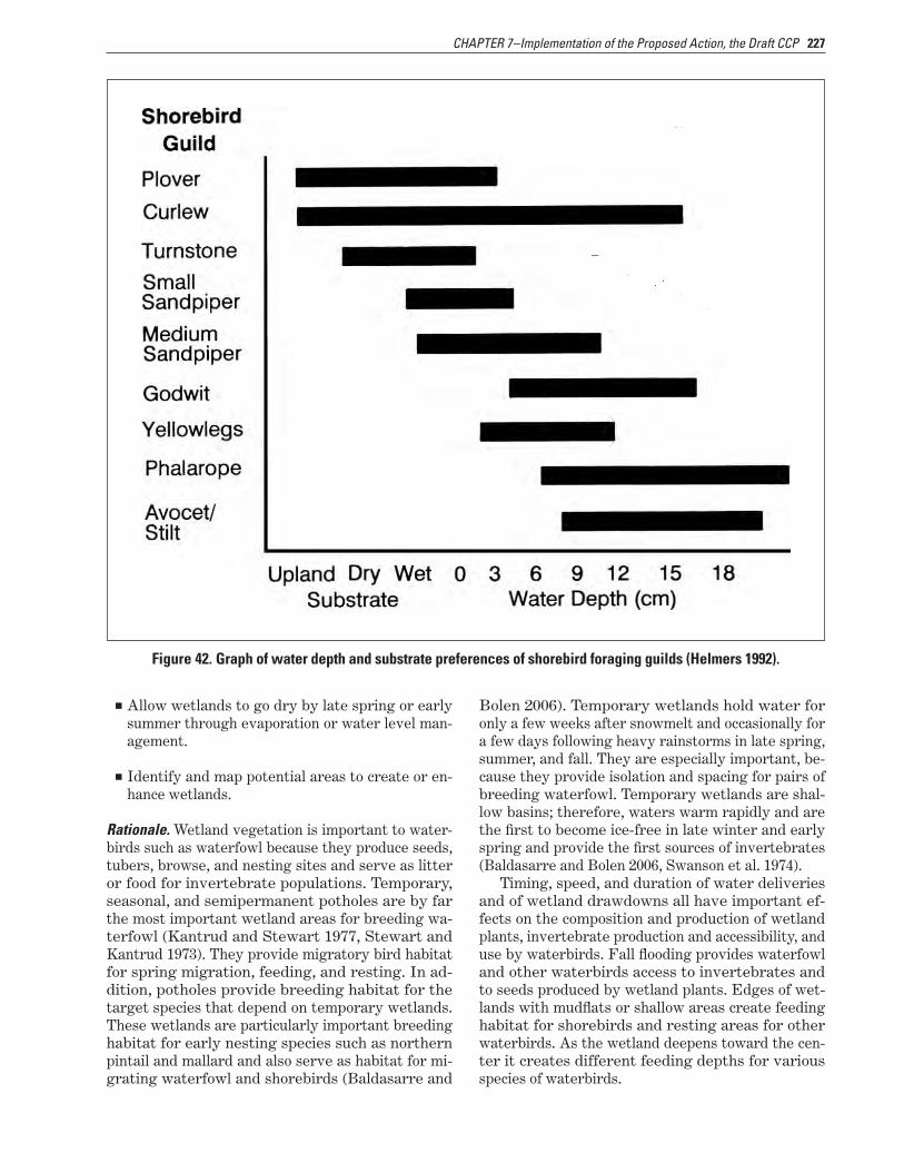
Shorebird Habitat Target SpeciesNearly 40 species of shorebirds migrate through the interior region of North America and 13 species breed in this region (Helmers 1992). Shorebirds ex-ploit upland habitats associated with wetlands by foraging in shallowly flooded pastures or ir-rigated agricultural fields with short, sparse, residual vegetation left from mowing, haying, graz-ing, or burning practices. Migra-tory shorebirds consume large numbers of invertebrates. Inver-
tebrate availability in wetlands is a function of the hydrologic regime. Many shorebirds feed predomi-nantly on chironomid larvae (blood worms), which occur in open shallow habitats with a silt substrate relatively free of vegetation.
Most shorebird use occurs where vegetation cover is less than 25 percent. Shorebirds prefer short vegetation, generally less than half the height of the bird. Nest sites for the target shorebirds range from sand or gravel substrate with no veg-etation (piping plover) to midgrass prairie (marbled godwit, willet). Managing for a range of wetland habitat conditions, from sparsely vegetated mudflats to moderately vegetated open shallows, would pro-vide shorebirds with required habitats throughout their migratory and breeding periods.
Eleven species of shorebirds have been docu-mented breeding on the Bowdoin National Wildlife Refuge Complex: piping plover, killdeer, long-billed curlew, common snipe, upland sandpiper, marbled

225CHAPTER 7–Implementation of the Proposed Action, the Draft CCP
godwit, willet, spotted sandpiper, American avocet, Wilson’s phalarope, and mountain plover. Shorebird habitat management in the refuge complex would emphasize provision of breeding habitat for three target species: piping plover, marbled godwit, and willet (table 17). These species represent different guilds (groups of species all members of which use similar resources in a similar way). Meeting the di-verse habitat requirements for these species would likely provide quality habitat for all shorebirds.
Spring migration habitat should be available on the refuge complex by mid-April that provides for-aging water depths of 0 (dry mud) to 0.6 feet (18 centimeters), which would meet the needs of these species, as specified below and in figure 42:
■■ Piping plover: 0–0.1 feet (0–3 centimeters)
■■ Marbled godwit: 0.1–0.5 feet (4–16 centimeters)
■■ Willet: 0–0.5 feet (0–16 centimeters)
Table 15. Conservation status of target species of waterbirds at Bowdoin National Wildlife Refuge Complex, Montana.
Species Montana species of concern
1U.S. Fish and Wildlife
Service focal speciesPartners in
Flight priority 2
Bureau of Land Management
3National Audubon
Watch List 4
Northern pintail — √ — — —
Mallard — √ — — —
Redhead — — — — —
Tundra swan — — — — —
Piping plover S2 Threatened 1 Special status Red
White-faced ibis S1 — 2 Sensitive —
Willet — — 3 — —
Franklin’s gull S3 — 2 Sensitive —
Wilson’s phalarope — √ 3 Sensitive Yellow
1 S1=At high risk because of extremely limited or rapidly declining numbers, range, or habitat, making it highly vulnerable to global extinction or extirpation in the State. S2=At risk because of very limited and potentially declining numbers, extent, or habitat, making it vulnerable to global extinction or extirpation in the State. S3=Potentially at risk because of limited and potentially declining numbers, extent, or habitat, even though it may be abundant in some areas. (Montana Fish, Wildlife & Parks; Montana Natural Heritage Program)2 1=Needs conservation action. 2=Needs monitoring. 3=Local concern.3 Special status or Sensitive=Proven to be imperiled in at least part of its range and documented to occur on Bureau of Land Management lands.4 Red=Declining rapidly or having very small populations or limited ranges and facing major conservation threats; typically of global conservation concern. Yellow=Declining or rare.
Wetland Habitat ObjectivesThe following objectives address management of the temporary, seasonal, and semipermanent wetlands within the Bowdoin Refuge Complex.
Wetland Habitat Objective 1Depending on the availability of delivered water and environmental conditions, fill at least 70 percent of the temporary wetlands to a maximum of 1.5 feet in spring (by April 15) for 3 out of every 5 years to provide breeding, nesting, feeding, and migration habitat for target waterbirds and feeding and breed-ing habitat for resident waterfowl and shorebirds.
Strategies
■■ Coordinate with Malta Irrigation District for timely water delivery to ensure water is avail-able for peak migration periods for waterbirds.
■■ Develop new ground-water wells to supplement wetland management needs in the refuge com-plex.
■■ Develop water-pumping sites on Beaver Creek WPA and McNeil Slough WPA to create wetland habitat for migratory birds.
■■ Manipulate water levels with flooding and draw-downs (natural and physical releases).
■■ Monitor the response of target waterbirds to habitat management.

226 Draft CCP and EA, Bowdoin National Wildlife Refuge Complex, Montana
Table 16. Life history needs of target species of waterbirds at Bowdoin National Wildlife Refuge Complex, Montana.
Species Arrival date Forage depth(feet)
Peak nest-ing month
Nesting site (distance above water line) Departure date
Northern pintailMid-March to early April
≤1.5 Mid-May Shortgrass uplands November
Mallard Mid-March ≤1.5 May Uplands, 2 feetFreeze-up to November
Emergent vegetation Redhead 1April 3.3–9.8 Late May (cattails and hardstem 1Early October
bulrush), 0.2–0.8 feet
Tundra swanLate March and late September
0–3.3 — —Early April andNovember
Marbled godwit 2Late April
30.2–0.4 MayMidgrass uplands,
4<0.5 feet
September
White-faced ibis 2May 0–1 MayCattails and bulrushes, 3 feet
September
Franklin’s gull Mid-April 50–0.5 May Cattail or bulrush mats Mid-October
Wilson’s phalarope Early May 0–0.25 June Uplands and wet meadowsMid-August toearly September
1Frank Belrose (1980).2Ryan and Renken (1987).3Melcher et al. (2006).4Eldridge (1992).5Refuge staff observations.Sources: Unless otherwise the noted, this information came from Birds of North America Online (Poole 2005) and Montana Field Guide (2010).
Table 17. Nest site and habitat characteristics of target, interior-nesting shorebirds at Bowdoin National Wildlife Refuge Complex, Montana.
Species Nest site Substrate Wetland type Vegetationheight
Vegetationdensity
Nestingbehavior
Piping plover Beach or Open, salt flats, Alkaline or saline None Sparse Semicolonialpeninsula or gravel
Marbled godwit Upland Open or vegetated Freshwater or Medium Moderate Solitarysaline
Willet Upland Open or vegetated Freshwater or Medium Moderate Solitaryprairie saline
Source: Helmers (1992).
■■ Monitor the response of plants and invertebrates to the timing of flooding and drawdowns.
■■ Monitor for undesirable plants such as cattail and bulrush. To maintain no more vegetation than a ratio of 70:30 for vegetation to open water, conduct management actions necessary to set back monocultures of these plants through flood-ing, prescribed burning, prescriptive grazing, or chemical use.
■■ Time flooding and drawdowns to mimic natural hydroperiods (wet cycles).
■■ Conduct all water manipulations slowly, so inver-tebrates can adjust to the changes in water level and temperature.
■■ Use mid- to late-summer water deliveries as part of managing large monocultures of cattails that reduce the availability of open-water habitat for waterbirds.
227CHAPTER 7–Implementation of the Proposed Action, the Draft CCP
■■ Allow wetlands to go dry by late spring or early summer through evaporation or water level man-agement.
■■ Identify and map potential areas to create or en-hance wetlands.
Figure 42. Graph of water depth and substrate preferences of shorebird foraging guilds (Helmers 1992).
Rationale. Wetland vegetation is important to water-birds such as waterfowl because they produce seeds, tubers, browse, and nesting sites and serve as litter or food for invertebrate populations. Temporary, seasonal, and semipermanent potholes are by far the most important wetland areas for breeding wa-terfowl (Kantrud and Stewart 1977, Stewart and Kantrud 1973). They provide migratory bird habitat for spring migration, feeding, and resting. In ad-dition, potholes provide breeding habitat for the target species that depend on temporary wetlands. These wetlands are particularly important breeding habitat for early nesting species such as northern pintail and mallard and also serve as habitat for mi-grating waterfowl and shorebirds (Baldasarre and
Bolen 2006). Temporary wetlands hold water for only a few weeks after snowmelt and occasionally for a few days following heavy rainstorms in late spring, summer, and fall. They are especially important, be-cause they provide isolation and spacing for pairs of breeding waterfowl. Temporary wetlands are shal-low basins; therefore, waters warm rapidly and are the first to become ice-free in late winter and early spring and provide the first sources of invertebrates (Baldasarre and Bolen 2006, Swanson et al. 1974).
Timing, speed, and duration of water deliveries and of wetland drawdowns all have important ef-fects on the composition and production of wetland plants, invertebrate production and accessibility, and use by waterbirds. Fall flooding provides waterfowl and other waterbirds access to invertebrates and to seeds produced by wetland plants. Edges of wet-lands with mudflats or shallow areas create feeding habitat for shorebirds and resting areas for other waterbirds. As the wetland deepens toward the cen-ter it creates different feeding depths for various species of waterbirds.

228 Draft CCP and EA, Bowdoin National Wildlife Refuge Complex, Montana
White-faced ibis congregate in a wetland at Bowdoin Refuge Complex.
US
FW
S
Wetland Habitat Objective 2Depending on the availability of delivered water and environmental conditions, fill at least 70 percent of the seasonal wetlands to a maximum of 1.5 feet in the spring or fall, or both, for 4 out of every 5 years to provide feeding, breeding, nesting, brood-rearing, and migration habitat for target waterfowl, shore-birds, and other waterbirds.
Strategies
■■ Coordinate with Malta Irrigation District for timely water delivery to ensure water is avail-able for peak migration periods for waterbirds.
■■ Acquire funding to buy additional delivered wa-ter from Malta Irrigation District (when avail-able) for Lake Bowdoin during the spring or fall, or both.
■■ Manipulate water levels with flooding and draw-downs (natural and physical releases).
■■ Time flooding and drawdowns to mimic natural hydroperiods.
■■ Conduct all water manipulations slowly, so inver-tebrates can adjust to the changes in water level and temperature.
■■ Monitor the response of plants and invertebrates to the timing of flooding and drawdowns.
■■ Monitor for undesirable plants such as cattail and bulrush. To maintain no more vegetation than a ratio of 70:30 for vegetation to open water, conduct management actions necessary to set back monocultures of these plants through flood-ing, prescribed burning, prescriptive grazing, or chemical use.
■■ Gradually fill temporary wetlands in late sum-mer (September) over a 2- to 3-week period to provide feeding habitat for fall-migrating shore-birds. Continue filling to a maximum of 1.5 feet by October 30 for use by fall-migrating waterfowl and other waterbirds and in preparation for the following spring migration.
■■ Gradually begin filling wetlands by the begin-ning of April over a 2- to 3-week period for spring migrants. Continue filling to a maximum of 1.5 feet by April 15 for use by spring-migrating wa-terfowl and other waterbirds.
■■ Provide a 70:30 ratio of emergent vegetation to water over 7–8 years, with cattails not occupy-ing more than 70 percent of a wetland. Remove 80–100 percent of cattails by using disking, burn-ing, or chemical treatment when cattails exceed 70 percent of the wetland surface.
■■ Use chemicals approved by the Service for aerial spraying to kill undesirable plants in wetlands.
Rationale. Seasonal wetlands maintain water in spring and early summer but normally are dry by
229CHAPTER 7–Implementation of the Proposed Action, the Draft CCP
late summer and early fall. They provide migrat-ing, feeding, and resting habitat for migratory waterbirds. In addition, seasonal wetlands provide habitat for breeding and brood rearing for species such as northern pintail, mallard, and marbled god-wit. These wetlands provide abundant invertebrate foods and other components of breeding habitat, including nesting cover for those species of ducks that nest over water (Baldasarre and Bolen 2006, Kantrud et al. 1989).
Waterfowl have various tolerances for the height and density of vegetation. Mallards and blue-winged teal readily use habitats with dense vegetation; northern pintails prefer shallow, open habitats where visibility is good and vegetation sparse. Shal-low water is essential for dabbling ducks such as northern pintails and mallards whose optimum for-aging depth is 0.2–0.8 feet. Wetland vegetation is im-portant, because it provides seeds, tubers, browse, and nesting sites for waterfowl; this vegetation serves as litter or food for invertebrate populations.
Timing, speed, and duration of water deliveries and of wetland drawdowns all have important ef-fects on the composition and production of wetland plants, invertebrate production and accessibility, and use by waterbirds. The key to managing habitat for migrating shorebirds is to encourage invertebrate production, and then make the invertebrates avail-able to the birds. The proper regime of drawdown and flooding can stimulate plant growth and decom-position and create a detrital food source for inver-tebrates. When the water is drawn down slowly (0.8–1.6 inches per week) during the appropriate times of the year, shorebirds are attracted to the available invertebrates. Shorebirds feed primarily on midge larvae during migration. Several studies revealed that, irrespective of wetland type, midge larvae are often the most abundant invertebrate. Midges are often most abundant in areas of shallow, open water that is not shaded by submergent and emergent vegetation. Because many waterfowl hens and broods also consume midge larvae, manage-ment of habitat for shorebirds is also beneficial for waterfowl (Eldridge 1992). Fall flooding provides waterfowl and other waterbirds access to inverte-brates and to any seeds produced by wetland plants and prepares the wetland for the following spring migrants.
Wetland Habitat Objective 3Depending on the availability of delivered water and environmental conditions, fill at least 70 percent of the semipermanent wetlands to provide shallow areas of a maximum of 1.5 feet (for dabbling ducks such as northern pintail and mallard and for wading birds such as white-faced ibis and willet) and deep
areas of 3–4 feet (for deep-water species such as lesser scaup). Allow emergent vegetation to estab-lish as nesting habitat for overwater nesters, but allow no more vegetation than a ratio of 70:30 of emergent vegetation to open water.
Strategies
■■ Time the delivery of the Malta Irrigation District water to achieve this objective.
■■ Manipulate water levels with flooding and draw-downs (natural and physical releases).
■■ Time flooding and drawdowns to coincide with the migration periods.
■■ Conduct all water manipulations slowly, so inver-tebrates can adjust to the changes in water level and temperature.
■■ Monitor the response of target waterbirds to these manipulations.
■■ Monitor the response of plants and invertebrates to the timing of flooding and drawdowns.
■■ Monitor for undesirable plants such as cattail and bulrush. To maintain no more vegetation than a ratio of 70:30 for vegetation to open water, con-duct management actions necessary to set back monocultures of these plants through prescribed burning, prescriptive grazing, flooding, mechani-cal treatment, or chemical use.
■■ Flood the uplands surrounding the emergent vegetation zone in early spring to kill wet meadow plants, allowing midges to rapidly colo-nize the detritus. Maintain the high water level, and then slowly lower it to expose the decompos-ing vegetation during the peak shorebird migra-tion.
■■ Through the nesting period, maintain 2–3 feet of water in areas with emergent vegetation for birds that nest over water.
■■ Fill 50 percent of the semipermanent wetlands to full capacity (at least 2–3 feet of water below the emergent vegetation) by May 15 to provide migration habitat for waterbirds, to serve as brood-rearing habitat for waterfowl, and to pro-vide nesting habitat for overwater nesters such as white-faced ibis, Franklin’s gull, and grebes. Annually rotate the wetlands that are flooded, allowing some to remain dry.

230 Draft CCP and EA, Bowdoin National Wildlife Refuge Complex, Montana
■■ Use drawdown structures or allow natural evaporation on these semipermanent wetlands to encourage nutrient recycling and increase production of invertebrates and desirable wet-land plants and seeds. Determine the timing of these drawdowns depending on weather condi-tions (particularly increasing temperatures to aid evaporation) and management objectives.
■■ Use chemicals approved by the Service for aerial spraying to kill undesirable plants.
Rationale. Semipermanent wetlands ordinarily retain water through spring and summer and frequently into fall and winter. They are highly important to diving ducks and especially important for dabbling ducks in years when drought limits the availability of temporary and seasonal wetlands. During drought conditions in North Dakota, mallard broods occurred only on semipermanent wetlands (Baldasarre and Bolen 2006, Talent et al. 1982), and 58-percent more duck broods were recorded using semipermanent potholes in comparison with other types of wetlands in North Dakota and South Dakota (Baldasarre and Bolen 2006, Duebbert and Frank 1984). Semiperma-nent wetlands provide migration habitat for migra-tory waterbirds such as diving ducks (redhead and lesser scaup) both in the spring and fall (if they still have water) but, more significantly, habitat for brood rearing and overwater nesting for waterbirds such as white-faced ibis. These wetlands also provide escape cover.
The structure created by emergent vegetation is an essential feature of wetland habitats. Weller and Spatcher (1965) recorded maximum diversity and abundance of birds on marshes in Iowa where the ratio of emergent vegetation to water was 50:50 and referred to this form of wetland physiognomy as hemimarsh (Baldasarre and Bolen 2006). Bul-rushes and especially cattails are among the most common plants in emergent communities. These plants are primarily important as cover, although alkali bulrushes are key food producers (Baldasarre and Bolen 2006). When conditions allow these plants to become a monoculture and overtake a wetland, animal and plant diversity declines. Wetland veg-etation is important to waterbirds such as waterfowl because they produce seeds, tubers, browse, and nesting sites and serve as litter or food for inverte-brate populations. Timing, speed, and duration of water deliveries and of wetland drawdowns all have important effects on the composition and production of wetland plants, invertebrate production and ac-cessibility, and use by waterbirds. Filling wetlands in the fall would make seeds from wetland plants more readily available to migrating waterbirds.
Alkali bulrush is a common emergent plant in the refuge complex.
S D
atab
ase
TN
AL
P SC
RN–
AD
R.H
. Moh
lenb
rock
/ U
S
Wetland Habitat Objective 4On semipermanent wetlands having limited manage-ment capabilities, manage emergent vegetation as a hemimarsh to provide open water and cover for migratory birds.
Strategies
■■ Monitor for undesirable emergents such as cat-tail and bulrush. To maintain no more vegetation than a ratio of 70:30 for vegetation to open water, conduct management actions necessary to set back monocultures of these plants through the use of a glyphosate or, where possible, through flooding, prescribed burning, prescriptive graz-ing, mechanical treatment, or chemical use.
■■ Restore the natural vertical structure in riparian corridors using native species such as cotton-wood, willows, and native shrubs to provide habi-tat for migratory birds and other native wildlife. Continue to fence riparian areas to protect them from trespass cattle grazing.
■■ Use chemicals approved by the Service for aerial spraying to kill undesirable plants.
■■ Monitor the response of waterbirds to manage-ment actions.
Rationale. Cattails are of little value as duck food but are more important as escape, loafing, and nesting cover for some species of waterfowl, other water-birds, and red-winged and yellow-headed blackbirds. However, when unchecked, cattail stands often ex-pand rapidly to the exclusion of other vegetation and open water; such conditions severely restrict

231CHAPTER 7–Implementation of the Proposed Action, the Draft CCP
waterfowl and shorebird use (Baldasarre and Bolen 2006, Kaminski et al. 1985).
The desired optimal wetland condition that pro-vides the greatest diversity and number of birds is hemimarsh. In hemimarsh conditions, wetland vegetation cover and water in a semipermanent wet-land is at a 50:50 ratio (Weller and Spatcher 1965). Wetland birds that find hemimarsh conditions favor-able include various waterfowl and shorebird species such as herons, gulls, terns, blackbirds, and grebes. All of the target species regularly use these par-ticular semipermanent managed wetlands at various times of the year. In addition, they provide ideal nesting cover for birds that nest over water. It is important to avoid undesirable plants and monocul-tures of plants in hemimarsh wetlands. Undesirable plants are plants that quickly shift diverse floral sys-tems toward monocultures, are difficult to reduce in abundance, have minimal values for wetland wildlife, or outcompete plants with greater value (Fredrick-son and Reid 1988b).
Through limited water level management or chemical use, or both, the Service anticipates being able to achieve emergent vegetation to open water ratios close to the 50:50 ratio (such as 30:70 and 70:30 ratios) recommended by Weller and Spatcher (1965) in most years (approximately 11 out of 15). Because of the dynamics involved with these particular wet-land conditions over time, the coverage of emergent vegetation may fall well outside the target range (30- to 70-percent coverage) in some years and, dur-ing years of extreme drought, cover of emergents such as cattail and bulrush may exceed the upper target of 70 percent.
The Drumbo, Goose Island, Patrol Road, Strater, and Black Coulee Ponds are considered semiperma-nent and the Service does not have complete man-agement capabilities in these wetlands because of subirrigation and irrigation return flows entering the refuge. Consequently, cattails have overgrown these wetlands.
Avian DiseaseThe refuge complex staff completed a Disease Con-tingency Plan in 2006 for the Bowdoin National Wildlife Refuge Complex. The Bowdoin Refuge has a history of botulism outbreaks, which generally begin in July and last into September. The numbers of waterfowl affected has varied greatly from year to year, while the location of disease hotspots—areas with the highest mortalities—has changed little: the southwestern and southeastern bays of Lake Bow-doin, the northeast shore of Big Island in Lake Bow-doin, and the northwest portion of Drumbo Pond.
A sudden die-off of pelicans on Lake Bowdoin in 2003 was the result of West Nile virus, and the disease has been documented in the area every year since this time. Outbreaks begin as early as July and can last into fall.
While not documented at the refuge complex, new disease threats continue to emerge such as highly pathogenic avian influenza and Newcastle disease. The Service can no longer afford to rely on past informal protocols for avian diseases.
Avian Disease ObjectiveManage wetlands to minimize or avoid outbreaks of avian botulism on the Bowdoin Refuge throughout the 15-year CCP. Continue to monitor for existing and new avian diseases throughout the refuge com-plex, particularly for those that might transfer to other wildlife and humans.
Strategies
■■ Follow the monitoring and response protocols outlined in the disease contingency plan.
■■ Annually review and update the disease contin-gency plan and continue to monitor for disease outbreaks within the refuge complex.
■■ Maintain a supply of personal protective equip-ment for emergency cleanup operations.
■■ Cooperate with partners who are responsible for detecting and monitoring existing and new wildlife diseases.
■■ Continue to submit tissue samples to the Na-tional Wildlife Health Center for disease diagno-sis.
■■ Avoid fluctuating water levels in botulism hotspots between early July and early Septem-ber when outbreaks are likely to occur; plan wa-ter deliveries during early spring (through May 15) and late summer (early September).
■■ As temperatures rise in the summer, monitor wetlands weekly for disease outbreaks. Send sample carcasses to the National Wildlife Health Center for analysis. Remove birds in areas with high visitor use.
■■ Continue to educate staff and visitors on how to avoid contact with wildlife diseases that have the potential to be transferred to humans.
232 Draft CCP and EA, Bowdoin National Wildlife Refuge Complex, Montana
■■ Continue to allow the U.S. Interagency Working Group to monitor the refuge complex for avian influenza outbreaks.
■■ When approved, implement the Mountain–Prai-rie Region policy for a mosquito control plan to address potential outbreaks of West Nile virus or avian influenza.
Rationale. America’s global economy and the abil-ity for individuals to easily travel around the world have escalated the transfer of new diseases, harm-ful to both animals and humans, to North America. Most recently, concerns have been raised over the potential migration to North America of highly pathogenic avian influenza. The Service’s response to this outbreak could rapidly change management of Service lands. Unlike avian botulism, highly pathogenic avian influenza and West Nile virus pose serious human health risks (USFWS 1999a). Service employees and visitors are made aware of disease symptoms and avoiding the risks of contracting these diseases before going into the field. Unfortu-nately the symptoms of these diseases make it im-possible to detect their presence and spread among wildlife until mortality occurs (Centers for Disease Control and Prevention 2010).
Avian botulism is a paralytic disease caused by ingestion of the Clostridium botulinum bacteria. The bacteria can exist as a dormant spore in soil for many years until a combination of warm tempera-tures, a protein source, and an anaerobic (no oxygen) environment allows the bacteria to become active and release its toxin. Decaying vegetation attracts a large number of aquatic invertebrates that pick up the toxin and are then ingested by waterfowl and shorebirds. A cycle develops when the affected birds die and the fly larvae that feed on the carcasses are, in turn, ingested by other birds. Sudden water draw-downs during this period could expand the spread of the botulism toxin by causing significant die-offs of aquatic invertebrates (Davis et al. 1971, USFWS 1999a). By avoiding the flooding of botulism hotspots during July through September, an outbreak would be avoided or at least reduced in severity.
Piping PloverThe northern Great Plains population of piping plo-ver consists of about half of the world population of this plover. This population is expected to go ex-tinct in 50–100 years unless significant conservation activities are started. Bowdoin National Wildlife Refuge has more than 1,300 acres of critical habitat
designated for the piping plover. The Service has collaborated with Reclamation and Ducks Unlimited to restore and create habitat for this threatened species.
Piping Plover Objective 1Over 15 years, annually monitor and protect piping plover nests found within the refuge complex and monitor the success of protected nests and hatched young. Strive for fledging rates of more than 1.36 fledglings per breeding pair of plovers (USFWS 2003).
Strategies
■■ Continue to participate in the International Piping Plover Census and annually monitor for the presence of piping plovers on Bowdoin and Hewitt Lake refuges.
■■ Survey wetlands for piping plovers by the most appropriate means (for example, by boat, walking the shoreline, or viewing from a vehicle with a spotting scope). Conduct surveys between late May and mid-June.
■■ Erect wire mesh cages with netted tops over piping plover nests that are in danger of being trampled or subjected to predation by birds.
■■ Move or elevate active nests that are in danger from rising water (Prellwitz et al. 1995).
■■ Monitor the success of protected nests by search-ing for “pip chips” (small pieces of egg shell left in the nest bowl during the hatching process) in or near the nest bowl or by timing nest visits based on known (or suspected) nest initiation date, lay-ing rate, and average incubation period.
■■ Monitor hatched young to when they fledge.
Rationale. The northern Great Plains population of piping plovers is listed as threatened in the United States (USFWS 1985) due to a poorly understood decline in abundance. Mabee and Estelle (2000) sug-gested that nest predation is a major problem limit-ing the nest success of piping plovers throughout their range. However, according to Murphy et al. (2003), predators can successfully be deterred from depredating eggs of piping plovers by placing large (10-foot diameter) mesh exclosures (cages) over indi-vidual nests. Recruitment has improved with the use of these cages in the northern Great Plains (Murphy

233CHAPTER 7–Implementation of the Proposed Action, the Draft CCP
et al. 2003). Exclosures placed after one or more eggs have been laid in the nest bowl have resulted in less than 2-percent nest abandonment (Atkinson and Dood 2006).
Beginning in 1991, biologists throughout North America collaborated in a monumental effort known as the International Piping Plover Census (Haig and Plissner 1993). Breeding and wintering habitats are censused at 5-year intervals to (1) establish bench-mark population levels for all known piping plover sites, (2) survey potential breeding and wintering sites, and (3) assess the current status of the species relative to past population estimates.
Piping Plover Chick
US
FW
S
Piping Plover Objective 2Over 15 years, improve and protect breeding, nest-ing, and feeding habitat on Piping Plover Pond at Bowdoin Refuge. Manage for gravel or alkaline beaches with no vegetation or vegetation that is short (less than 0.3 feet) and sparse (less than 10 percent cover), that are at least 65.6 feet wide, and that provide water for foraging throughout the breeding and brood-rearing season.
Strategies
■■ Monitor Piping Plover pond for encroachment of invasive plants, trees, and other tall vegetation.
Maintain at least 90-percent bare gravel on nest-ing beaches.
■■ Apply herbicides, mechanical disturbance, or other means to remove upland vegetation before the breeding season or after plovers have left the area. Restrict control activities between May 15 and August 7 (Stewart 1975) or any time that piping plovers are present on the beaches.
■■ Acquire money to buy the water resources neces-sary to properly manage piping plover habitat at Bowdoin Refuge.
■■ Continue to work with Reclamation and other agencies to acquire additional knowledge and resources to improve and protect piping plover habitat on Piping Plover Pond at Bowdoin Ref-uge.
■■ Deliver water to Piping Plover Pond during the fall or spring, before the breeding season (refer to above Managed Wetlands section).
Rationale. In Montana, spring arrival of piping plo-vers usually occurs from late April through early May and departure is by late August (Lenard et al. 2003, Montana Piping Plover Recovery Committee 1997). Soon after spring arrival, male piping plovers begin establishing and defending territories that include a section of shoreline and an area of open ground (Whyte 1985).
Studies and observations of nesting habitat used by piping plovers indicate that the birds prefer a combination of suitable nesting substrate, lack of vegetative cover, existence of favorable water con-ditions, and availability of suitable forage habitat (Corn and Armbruster 1993, Licht 2001, Prindi-ville-Gaines and Ryan 1988, Root and Ryan 2004, Schwalbach 1988, Ziewitz et al. 1992). Sites with gravel substrate appear to provide the most suitable habitat and eggs there are more likely to hatch than those on alkali substrate (Prindiville-Gaines and Ryan 1988, Whyte 1985). Espie et al. (1996) found that, in Saskatchewan, depredated piping plover nests were generally closer to vegetation than suc-cessful nests. Prindiville-Gaines and Ryan (1988) found that breeding piping plovers chose territories with an average beach width of 82 feet, with opti-mal habitat characteristics of greater than 65.6 feet. Nesting sites studied by Schwalbach (1988) were found to be characteristically barren or with short (less than 0.3 feet) and sparse (less than 10-percent) vegetative cover.

234 Draft CCP and EA, Bowdoin National Wildlife Refuge Complex, Montana
7.6 Objectives that Support the Goals for Upland and Wetland Habitats
To meet the goals for both upland and wetland habi-tats, the Service would treat invasive and nonnative species, suppress wildfires, and carry out habitat protection and acquisition. All of these activities would directly affect the ability of the Bowdoin Ref-uge Complex to meet the goals for upland and wet-land habitats.
Invasive and Nonnative SpeciesInvasive species, nonnative species, and noxious weeds are major threats to native upland and wet-land ecosystems in the United States. Infestations of invasive species have a direct effect on the ability of the Bowdoin National Wildlife Refuge Complex to fulfill its wildlife conservation mission including species recovery, biological diversity, biological in-tegrity, and natural functions.
Montana’s noxious weed list contains 32 species and the Montana Department of Agriculture has cat-egorized noxious weeds into four categories based on the invasion stage of each species:
■■ Priority 1A—weeds that are not yet found in Montana
■■ Priority 1B—weeds that have a limited presence in the State
■■ Priority 2A—weeds that are common in isolated areas of Montana
■■ Priority 2B—weeds that are abundant and wide-spread
The refuge complex does not have any priority 1A or 1B species. At Bowdoin Refuge, there is an infesta-tion of perennial pepperweed, which is a priority 2A species. Most of the refuge complex’s noxious weeds are in the priority 2B category: leafy spurge, spotted knapweed, Canada thistle, yellow toadflax, and saltcedar. In addition, the refuge complex has in-festations of other nonnative, invasive species that, although they are not listed as noxious weeds by the State, may have negative effects on desirable refuge habitats: Russian olive, crested wheatgrass, reed canarygrass, Japanese brome, and Phragmites.
Some of the undesirable, nonnative species are within shelterbelts in the refuge complex. These
shelterbelts were probably planted in the 1930s or 1940s for wildlife and around existing homesteads before the land was purchased by the Service; the shelterbelts consist mostly of Russian olive trees and caragana and cover about 8 acres.
Invasive and Nonnative Species Objective 1Over 15 years, eradicate at least 25 acres of Russian olive trees and other nonnative trees and shrubs. Restore the sites to native herbaceous species that in 10 years postestablishment would comprise more than 60-percent native grasses and forbs throughout the refuge complex.
Strategies
■■ Map all treatment sites.
■■ Cut all standing trees and treat stumps with ap-propriate herbicide.
■■ As appropriate, use chemicals approved by the Service for aerial spraying to kill Russian olive trees.
■■ To remove woody material, use machinery to cut and shred the trees and bushes or pile and burn them.
■■ Remove vegetation that is impeding water deliv-ery systems and boundary fences.
■■ Begin removing all shelterbelts to create more contiguous blocks of grassland habitat, and restore it to prevent invasive species from en-croaching. Allow no additional shelterbelts.
■■ Monitor and diligently re-treat areas to prevent reinfestation.
■■ Restore bare areas resulting from the removal of Russian olive trees to native grass cover and monitor the results.
■■ Develop a program that provides information to the local community, partners, media, and other interested individuals or groups about the need to remove Russian olive trees to reduce the frag-mentation of grassland habitat and to maintain the refuge canals used for managing wetlands.
■■ Collaborate with the Malta Irrigation District and Reclamation to treat Russian olive trees that occur along the Dodson South Canal, which is the major water delivery canal for Bowdoin Refuge.

235CHAPTER 7–Implementation of the Proposed Action, the Draft CCP
■■ Network with other agencies and refuges to stay current on effective treatment methods and to share equipment and resources.
■■ Map current infestations and actively monitor (at least every 3 years) these sites for new invasions. Immediately treat any new invasion to prevent expansion.
Rationale. Research indicates that native grassland birds need large, uninterrupted tracts of treeless grasslands (Bakker et al. 2002, Herkert 1994, Winter et al. 1999). Preventing the encroachment of woody vegetation into grassland systems contributes sig-nificantly to the recovery of grassland bird popula-tions (Herkert 1994). The literature overwhelmingly indicates that planted and exotic trees in prairie landscapes often negatively affect a variety of birds (Bakker 2003). Specifically, trees on the prairie are correlated with negative consequences to ducks (Rumble and Flake 1983), other wetland birds (Nau-gle et al. 1999), prairie grouse (Hanowski et al. 2000, Niemuth 2000), grassland passerines (Grant et al. 2004, Winter et al. 2000), and ring-necked pheas-ants (Schmitz and Clark 1999, Snyder 1984). The effect of trees on the prairie landscape is greater than their “footprint,” because they also affect the surrounding habitat. Many grassland birds avoid areas near trees, and bird abundance and nest suc-
cess increases as distance to trees increases (Delisle and Savidge 1996, Gazda et al. 2002, Helzer 1996, Johnson and Temple 1990). For example, at one time there were nine active lek sites on Bowdoin Refuge. Today there are none. The Service speculates that this may be directly tied to the invasion of Russian olive trees and other nonnative woody vegetation into what was once contiguous grassland habitat. Research supports this theory, including numerous studies that determined sharp-tailed grouse leks were abandoned as tree cover increased, even as far away as 2 miles (Hanowski 2000). A study of active and inactive leks in Minnesota concluded that ac-tive sharp-tailed grouse leks had significantly lower proportions of upland forest and brush cover types and higher percentages of native grasses than inac-tive leks (Hanowski 2000). Gregg (1987) and Prose (1987) showed preferred lek sites by sharp-tailed grouse are characterized by low, sparse vegetation and that an excess of woody cover, within 2,625 feet of the lek site (well over half a mile), has a negative effect on the number of dancing males. Although Russian olive trees and other woody vegetation are often planted to benefit birds like grouse and pheas-ants, Kelsey et al. (2006) found that the detrimental effects of fragmenting grassland habitat, which re-duces nesting success and increases predation, far outweighed any benefits to these species.
Nonnative Russian olive along Lakeside Canal in the Teal Pond area.
Mik
e A
rtm
ann
/ US
FW
S
236 Draft CCP and EA, Bowdoin National Wildlife Refuge Complex, Montana
The Russian olive infestation on Bowdoin Ref-uge is so extensive that it can seem overwhelming (figure 43). After more than 30 years of unchecked growth and expansion, some areas such as the north-west corner of Big Island, Dry Lake Canal, and around Dry Lake Pond have become virtual Rus-sian olive forests. The Russian olive stand on Big Island was chosen as the first target area because it is mostly native prairie, the infestation is relatively small (12 acres), and it is an “island” isolated from other areas making it unlikely to be reinvaded. A second target area is about 7 acres of trees around Piping Plover Pond. This wetland was enhanced to provide nesting habitat for piping plovers, and re-moving trees would benefit this threatened species. In addition to the two target areas, about 8 acres of shelterbelts in the refuge complex would be re-moved, and additional Russian olive removal would take place as needed.
By removing Russian olive trees, the positive ef-fects on grassland-nesting birds in the native prairie can be substantial. For example, using a 328-foot (100-meter) buffer around groups of trees, the Ser-vice estimates that removing 12 acres of Russian olive trees on Big Island may actually improve at least 50 acres of prairie habitat for some grassland birds (figure 44). Improving nesting habitat for mi-gratory birds through removal of Russian olive trees is necessary and required, by policy, to support and achieve the establishing purposes of the units within the refuge complex.
Combining treatments—such as mowing sap-lings, cutting trees, girdling, burning, grinding and chipping stands of small and possibly large trees, and chemical use—is the most effective means of controlling Russian olive because the effects are cu-mulative and would act on the plant at all life stages (Natural Resources Conservation Service 2002). Treatment would require funding, equipment, and staff for effective control and possible eradication of small infestations. Complete eradication of Russian olive is often impractical; however, it is practical for small isolated stands where the cost of control and time investment is small (Natural Resources Con-servation Service 2002).
The proposed removal of 75 acres of Russian olive trees over 15 years may seem like a small amount given the timeframe. However, the refuge staff believes anything more would be unrealistic for the following reasons:
■■ Removal of Russian olive trees on this scale is time- and labor-intensive. In the past, the lack of funding and staff has meant that removal has been sporadic and slow.
■■ Current treatment methods and available herbi-cides are inefficient. For example, trees on Bow-doin Refuge that the Service has cut and treated often resprout from the roots, so the same areas must be re-treated for up to 5 years in some cases for good control. Plants are generally produced from stratified seed, but plants can grow from stump sprouts, stem cuttings, and root pieces (Natural Resources Conservation Service 2002). (Note: Because the embryos of many tree and shrub seeds are immature when the seeds fall, the embryos require time in a moist, cool envi-ronment to develop to the point where they can germinate—a process called stratification.)
■■ Cutting, grinding, and treating the trees is only the first step. If the Service is unable to use ma-chinery to grind up the trees, the debris must be removed or gathered into piles and burned. This often involves heavy equipment that can disturb the surrounding grassland. To prevent invasive plant infestation, the entire area would have to be reseeded to native herbaceous vegetation. Revegetation should be done with the objective of providing plants that are well adapted and that can suppress the spread and growth of Russian olive (Natural Resources Conservation Service 2002). Continued monitoring and treatment of these areas would take many years.
■■ Russian olive trees on private land surround Bowdoin Refuge (figure 43). The Dodson South Canal (owned by Reclamation and maintained by the Malta Irrigation District), which delivers wa-ter to the refuge, is lined with Russian olive trees for miles. Even if every Russian olive tree on the refuge were removed, there would be a constant source of seeds from across the boundary fence and coming into the refuge with delivered water.
However, increased funding or staff, or improved treatment methods, could increase the amount of acres treated and restored over the life of the CCP. Russian olive is not listed as a noxious weed in Mon-tana but is listed in several other western States; subsequently, the Federal, State, and local agencies in these States are becoming more active in control-ling Russian olive. The Salt Cedar and Russian Olive Control Demonstration Act, passed in 2006, directed the Secretaries of the Interior, Agriculture, and De-fense to establish a Federal program aimed at find-ing and carrying out the best means of controlling and eradicating Russian olive and saltcedar.

237CHAPTER 7–Implementation of the Proposed Action, the Draft CCP
Figu
re 4
3. M
ap o
f Rus
sian
oliv
e tr
ee in
fest
atio
ns in
and
aro
und
Bow
doin
Nat
iona
l Wild
life
Refu
ge, M
onta
na.
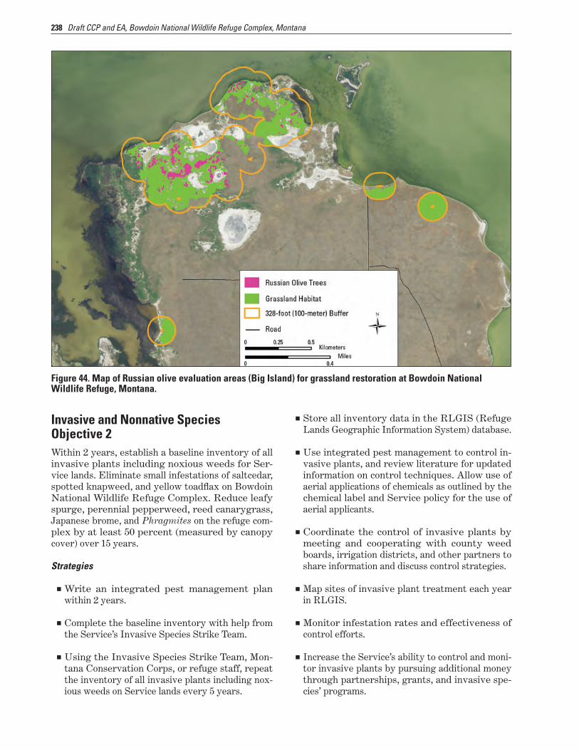
238 Draft CCP and EA, Bowdoin National Wildlife Refuge Complex, Montana
Invasive and Nonnative Species Objective 2Within 2 years, establish a baseline inventory of all invasive plants including noxious weeds for Ser-vice lands. Eliminate small infestations of saltcedar, spotted knapweed, and yellow toadflax on Bowdoin National Wildlife Refuge Complex. Reduce leafy spurge, perennial pepperweed, reed canarygrass, Japanese brome, and Phragmites on the refuge com-plex by at least 50 percent (measured by canopy cover) over 15 years.
Figure 44. Map of Russian olive evaluation areas (Big Island) for grassland restoration at Bowdoin National Wildlife Refuge, Montana.
Strategies
■■ Write an integrated pest management plan within 2 years.
■■ Complete the baseline inventory with help from the Service’s Invasive Species Strike Team.
■■ Using the Invasive Species Strike Team, Mon-tana Conservation Corps, or refuge staff, repeat the inventory of all invasive plants including nox-ious weeds on Service lands every 5 years.
■■ Store all inventory data in the RLGIS (Refuge Lands Geographic Information System) database.
■■ Use integrated pest management to control in-vasive plants, and review literature for updated information on control techniques. Allow use of aerial applications of chemicals as outlined by the chemical label and Service policy for the use of aerial applicants.
■■ Coordinate the control of invasive plants by meeting and cooperating with county weed boards, irrigation districts, and other partners to share information and discuss control strategies.
■■ Map sites of invasive plant treatment each year in RLGIS.
■■ Monitor infestation rates and effectiveness of control efforts.
■■ Increase the Service’s ability to control and moni-tor invasive plants by pursuing additional money through partnerships, grants, and invasive spe-cies’ programs.

239CHAPTER 7–Implementation of the Proposed Action, the Draft CCP
■■ Familiarize all staff with State-listed noxious weeds including staying current on potential new threats to Service lands.
■■ Map and store in RLGIS the invasive plant infes-tations noted by Service staff while conducting other work activities.
■■ Deploy early detection and rapid response strate-gies to attack newly found infestations before they become larger, causing harm and becoming more costly to treat.
Rationale. These problem plants can displace native vegetation over large areas, have the ability to form nearly monotypic stands in the absence of manage-ment, and, therefore, threaten native biodiversity (Bedunah 1992, Hutchison 1992, Svedarsky and Van Amburg 1996, Trammel and Butler 1995, Watson 1985). The control or elimination of invasive plants on Service lands would comply with State and Fed-eral laws for invasive and noxious species.
Trying to manage an invasive plant infestation without any idea of the size, canopy cover, or rate of spread would jeopardize the efficiency of the control efforts and waste precious time and resources. An inventory would help prioritize the strategies for elimination of new and isolated infestations and con-tainment or reduction of larger infestations.
Invasive and Nonnative Species Objective 3Within 5 years, treat 20 acres of native grassland with varying degrees of crested wheatgrass in-
festation using a mix of treatments to determine effectiveness. Based on the results, add crested wheatgrass management to the integrated pest management plan.
Strategies
■■ Work with local universities to recruit graduate students to conduct research projects on control-ling crested wheatgrass on the refuge complex.
■■ Within 2 years, ground-truth the vegetation map to verify the extent of the crested wheatgrass infestation on Bowdoin Refuge.
■■ Identify four 5-acre plots on Bowdoin Refuge that are in various stages of crested wheatgrass infestation, from initial invasion with individ-ual plants making up less than 5 percent of the cover to where the cover is more than 50-percent crested wheatgrass. Using the best available sci-ence, apply to the plots and monitor effectiveness of a combination of treatments (such as wicking or spot spraying with herbicides, haying, pre-scriptive grazing, prescribed burning, and seed-ing of native grasses and forbs).
■■ Use the results of the plot treatments to develop a plan for management and reduction of crested wheatgrass across the entire refuge complex.
■■ Continue to work with other refuges, Grasslands National Park (Saskatchewan), University of Regina, and other agencies and organizations to apply adaptive management to control of crested wheatgrass as new data and treatment methods become available.
Rationale. Planted to stabilize soil on abandoned cropland during the drought of the 1920s and 1930s and as a hay and forage crop for cattle ever since, there are 15–26 million acres of crested wheatgrass on this continent today (Lesica and DeLuca 1996). Although it may be useful for agricultural purposes, rangeland dominated by crested wheatgrass has reduced value to wildlife, especially migratory birds, compared to native rangeland. Lloyd and Martin (2005) found that reproductive success of chestnut-collared longspurs was significantly lower in crested wheatgrass stands than in native prairie.
In addition to its negative effects on plant and wildlife diversity, crested wheatgrass can be detri-mental to soil conditions by making it harder to get native seeds established, which can cause erosion and increase the chances of invasion by invasive plants (Ambrose and Wilson 2003, Jordan et al. 2008, McWilliams and Van Cleave 1960).Reed Canarygrass
She
ri H
agw
ood
/ Bur
eau
of L
and
Man
agem
ent
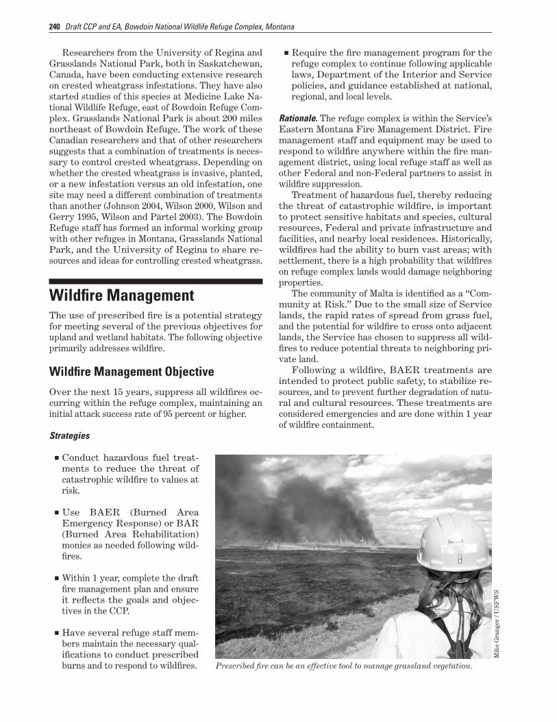
240 Draft CCP and EA, Bowdoin National Wildlife Refuge Complex, Montana
Researchers from the University of Regina and Grasslands National Park, both in Saskatchewan, Canada, have been conducting extensive research on crested wheatgrass infestations. They have also started studies of this species at Medicine Lake Na-tional Wildlife Refuge, east of Bowdoin Refuge Com-plex. Grasslands National Park is about 200 miles northeast of Bowdoin Refuge. The work of these Canadian researchers and that of other researchers suggests that a combination of treatments is neces-sary to control crested wheatgrass. Depending on whether the crested wheatgrass is invasive, planted, or a new infestation versus an old infestation, one site may need a different combination of treatments than another (Johnson 2004, Wilson 2000, Wilson and Gerry 1995, Wilson and Pärtel 2003). The Bowdoin Refuge staff has formed an informal working group with other refuges in Montana, Grasslands National Park, and the University of Regina to share re-sources and ideas for controlling crested wheatgrass.
Wildfire ManagementThe use of prescribed fire is a potential strategy for meeting several of the previous objectives for upland and wetland habitats. The following objective primarily addresses wildfire.
Wildfire Management ObjectiveOver the next 15 years, suppress all wildfires oc-curring within the refuge complex, maintaining an initial attack success rate of 95 percent or higher.
Strategies
■■ Conduct hazardous fuel treat-ments to reduce the threat of catastrophic wildfire to values at risk.
■■ Use BAER (Burned Area Emergency Response) or BAR (Burned Area Rehabilitation) monies as needed following wild-fires.
■■ Within 1 year, complete the draft fire management plan and ensure it reflects the goals and objec-tives in the CCP.
■■ Have several refuge staff mem-bers maintain the necessary qual-ifications to conduct prescribed burns and to respond to wildfires.
■■ Require the fire management program for the refuge complex to continue following applicable laws, Department of the Interior and Service policies, and guidance established at national, regional, and local levels.
Rationale. The refuge complex is within the Service’s Eastern Montana Fire Management District. Fire management staff and equipment may be used to respond to wildfire anywhere within the fire man-agement district, using local refuge staff as well as other Federal and non-Federal partners to assist in wildfire suppression.
Treatment of hazardous fuel, thereby reducing the threat of catastrophic wildfire, is important to protect sensitive habitats and species, cultural resources, Federal and private infrastructure and facilities, and nearby local residences. Historically, wildfires had the ability to burn vast areas; with settlement, there is a high probability that wildfires on refuge complex lands would damage neighboring properties.
The community of Malta is identified as a “Com-munity at Risk.” Due to the small size of Service lands, the rapid rates of spread from grass fuel, and the potential for wildfire to cross onto adjacent lands, the Service has chosen to suppress all wild-fires to reduce potential threats to neighboring pri-vate land.
Following a wildfire, BAER treatments are intended to protect public safety, to stabilize re-sources, and to prevent further degradation of natu-ral and cultural resources. These treatments are considered emergencies and are done within 1 year of wildfire containment.
Prescribed fire can be an effective tool to manage grassland vegetation.
Mik
e G
rang
er /
US
FW
S
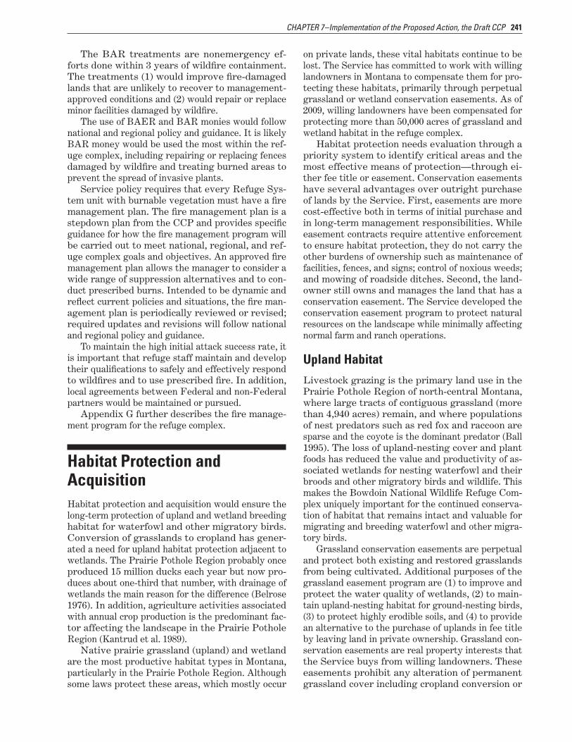
241CHAPTER 7–Implementation of the Proposed Action, the Draft CCP
The BAR treatments are nonemergency ef-forts done within 3 years of wildfire containment. The treatments (1) would improve fire-damaged lands that are unlikely to recover to management-approved conditions and (2) would repair or replace minor facilities damaged by wildfire.
The use of BAER and BAR monies would follow national and regional policy and guidance. It is likely BAR money would be used the most within the ref-uge complex, including repairing or replacing fences damaged by wildfire and treating burned areas to prevent the spread of invasive plants.
Service policy requires that every Refuge Sys-tem unit with burnable vegetation must have a fire management plan. The fire management plan is a stepdown plan from the CCP and provides specific guidance for how the fire management program will be carried out to meet national, regional, and ref-uge complex goals and objectives. An approved fire management plan allows the manager to consider a wide range of suppression alternatives and to con-duct prescribed burns. Intended to be dynamic and reflect current policies and situations, the fire man-agement plan is periodically reviewed or revised; required updates and revisions will follow national and regional policy and guidance.
To maintain the high initial attack success rate, it is important that refuge staff maintain and develop their qualifications to safely and effectively respond to wildfires and to use prescribed fire. In addition, local agreements between Federal and non-Federal partners would be maintained or pursued.
Appendix G further describes the fire manage-ment program for the refuge complex.
Habitat Protection and AcquisitionHabitat protection and acquisition would ensure the long-term protection of upland and wetland breeding habitat for waterfowl and other migratory birds. Conversion of grasslands to cropland has gener-ated a need for upland habitat protection adjacent to wetlands. The Prairie Pothole Region probably once produced 15 million ducks each year but now pro-duces about one-third that number, with drainage of wetlands the main reason for the difference (Belrose 1976). In addition, agriculture activities associated with annual crop production is the predominant fac-tor affecting the landscape in the Prairie Pothole Region (Kantrud et al. 1989).
Native prairie grassland (upland) and wetland are the most productive habitat types in Montana, particularly in the Prairie Pothole Region. Although some laws protect these areas, which mostly occur
on private lands, these vital habitats continue to be lost. The Service has committed to work with willing landowners in Montana to compensate them for pro-tecting these habitats, primarily through perpetual grassland or wetland conservation easements. As of 2009, willing landowners have been compensated for protecting more than 50,000 acres of grassland and wetland habitat in the refuge complex.
Habitat protection needs evaluation through a priority system to identify critical areas and the most effective means of protection—through ei-ther fee title or easement. Conservation easements have several advantages over outright purchase of lands by the Service. First, easements are more cost-effective both in terms of initial purchase and in long-term management responsibilities. While easement contracts require attentive enforcement to ensure habitat protection, they do not carry the other burdens of ownership such as maintenance of facilities, fences, and signs; control of noxious weeds; and mowing of roadside ditches. Second, the land-owner still owns and manages the land that has a conservation easement. The Service developed the conservation easement program to protect natural resources on the landscape while minimally affecting normal farm and ranch operations.
Upland HabitatLivestock grazing is the primary land use in the Prairie Pothole Region of north-central Montana, where large tracts of contiguous grassland (more than 4,940 acres) remain, and where populations of nest predators such as red fox and raccoon are sparse and the coyote is the dominant predator (Ball 1995). The loss of upland-nesting cover and plant foods has reduced the value and productivity of as-sociated wetlands for nesting waterfowl and their broods and other migratory birds and wildlife. This makes the Bowdoin National Wildlife Refuge Com-plex uniquely important for the continued conserva-tion of habitat that remains intact and valuable for migrating and breeding waterfowl and other migra-tory birds.
Grassland conservation easements are perpetual and protect both existing and restored grasslands from being cultivated. Additional purposes of the grassland easement program are (1) to improve and protect the water quality of wetlands, (2) to main-tain upland-nesting habitat for ground-nesting birds, (3) to protect highly erodible soils, and (4) to provide an alternative to the purchase of uplands in fee title by leaving land in private ownership. Grassland con-servation easements are real property interests that the Service buys from willing landowners. These easements prohibit any alteration of permanent grassland cover including cropland conversion or
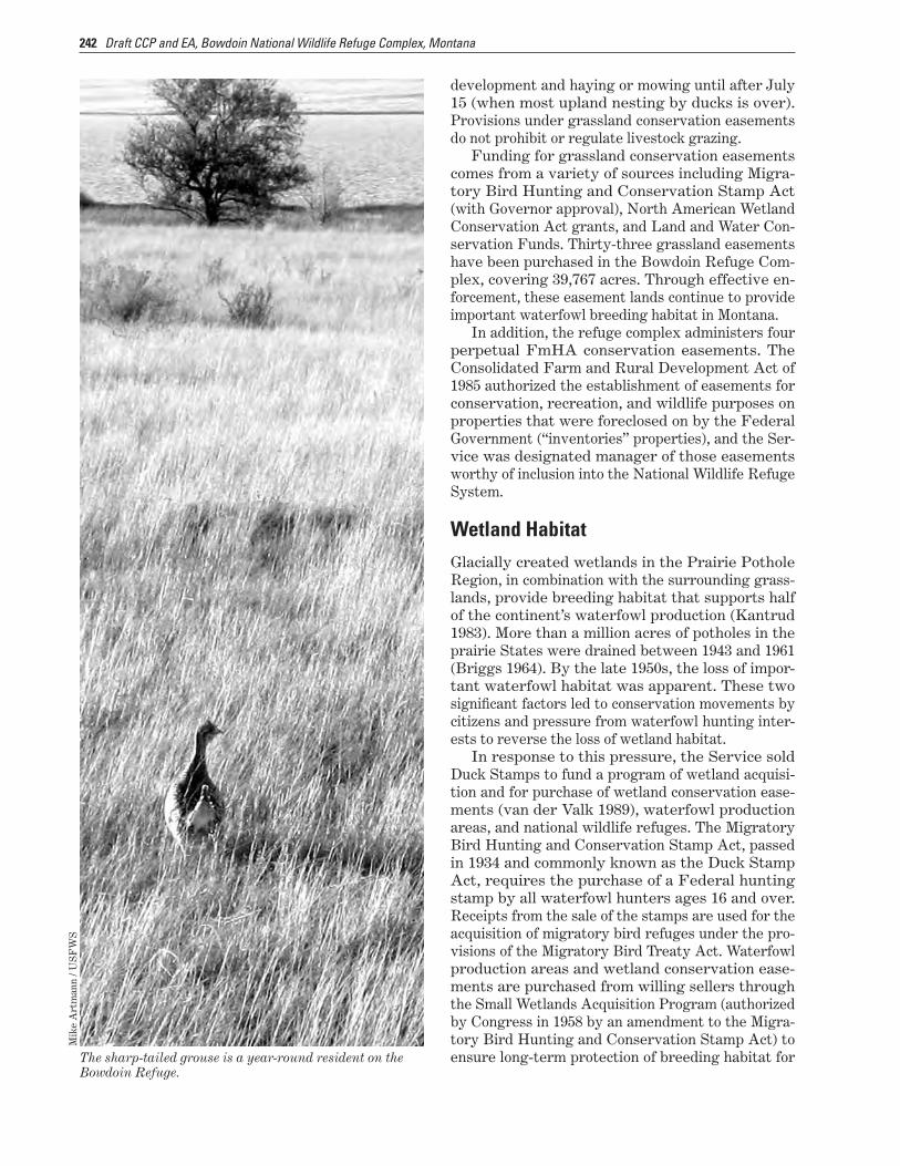
242 Draft CCP and EA, Bowdoin National Wildlife Refuge Complex, Montana
development and haying or mowing until after July 15 (when most upland nesting by ducks is over). Provisions under grassland conservation easements do not prohibit or regulate livestock grazing.
Funding for grassland conservation easements comes from a variety of sources including Migra-tory Bird Hunting and Conservation Stamp Act (with Governor approval), North American Wetland Conservation Act grants, and Land and Water Con-servation Funds. Thirty-three grassland easements have been purchased in the Bowdoin Refuge Com-plex, covering 39,767 acres. Through effective en-forcement, these easement lands continue to provide important waterfowl breeding habitat in Montana.
In addition, the refuge complex administers four perpetual FmHA conservation easements. The Consolidated Farm and Rural Development Act of 1985 authorized the establishment of easements for conservation, recreation, and wildlife purposes on properties that were foreclosed on by the Federal Government (“inventories” properties), and the Ser-vice was designated manager of those easements worthy of inclusion into the National Wildlife Refuge System.
The sharp-tailed grouse is a year-round resident on the Bowdoin Refuge.
Mik
e A
rtm
ann
/ US
FW
S
Wetland HabitatGlacially created wetlands in the Prairie Pothole Region, in combination with the surrounding grass-lands, provide breeding habitat that supports half of the continent’s waterfowl production (Kantrud 1983). More than a million acres of potholes in the prairie States were drained between 1943 and 1961 (Briggs 1964). By the late 1950s, the loss of impor-tant waterfowl habitat was apparent. These two significant factors led to conservation movements by citizens and pressure from waterfowl hunting inter-ests to reverse the loss of wetland habitat.
In response to this pressure, the Service sold Duck Stamps to fund a program of wetland acquisi-tion and for purchase of wetland conservation ease-ments (van der Valk 1989), waterfowl production areas, and national wildlife refuges. The Migratory Bird Hunting and Conservation Stamp Act, passed in 1934 and commonly known as the Duck Stamp Act, requires the purchase of a Federal hunting stamp by all waterfowl hunters ages 16 and over. Receipts from the sale of the stamps are used for the acquisition of migratory bird refuges under the pro-visions of the Migratory Bird Treaty Act. Waterfowl production areas and wetland conservation ease-ments are purchased from willing sellers through the Small Wetlands Acquisition Program (authorized by Congress in 1958 by an amendment to the Migra-tory Bird Hunting and Conservation Stamp Act) to ensure long-term protection of breeding habitat for

243CHAPTER 7–Implementation of the Proposed Action, the Draft CCP
migratory birds, primarily within the Prairie Pot-hole Region of the United States.
The Bowdoin Wetland Management District—comprised of waterfowl production areas and con-servation easements—was established in 1973 under the authority of the Migratory Bird Hunting and Conservation Stamp Act to reduce waterfowl habi-tat loss in north-central Montana.
■■ The district’s first waterfowl production area was purchased on April 19, 1977, in Blaine County. The Service manages these fee-title areas to pro-vide breeding waterfowl with quality wetlands for courtship and brood rearing, as well as suit-able grasslands for nesting. The Bowdoin Wet-land Management District has nine waterfowl production areas totaling 9,504 acres.
■■ The first wetland conservation easement was purchased on April 14, 1977, in Phillips County. To date, 125 wetland easements have been purchased within the refuge complex, cover-ing 10,635 wetland acres. Wetland conservation easements are perpetual and prohibit the filling, leveling, draining, or burning of wetlands under easement. These easements are real-property interests that the Service buys from willing land-owners and are permanent fixtures to land titles. The land remains in private ownership and the landowner controls public access. Through ef-fective enforcement of easement provisions, the lands under easement provide important water-fowl breeding habitat.
Habitat Protection and Acquisition Objective 1Over the next 15 years, protect at least 900 acres of depressional wetlands and 16,000 acres of grasslands on private land within the refuge complex through the purchase of perpetual conservation easements or fee title from willing sellers.
Strategies
■■ Work with HAPET to develop a waterfowl-pair density map for the counties within the wetland management district.
■■ Implement the conceptual waterfowl habitat model developed by HAPET to identify and pri-oritize areas for protection with conservation easements.
■■ Focus the protection of wetlands with conserva-tion easements in areas where the Service is also protecting priority grasslands.
■■ Use mass mailings and public meetings to pro-vide prospective sellers with information about the conservation easement program.
■■ Continue to piggyback on the Partners for Fish and Wildlife Program as a way to inform pro-spective sellers of the conservation easement program.
■■ Buy additional waterfowl production areas in-cluding “round-outs” and inholdings from willing sellers.
■■ Use the Service’s strong partnership with Ducks Unlimited and other conservation organizations to generate other funding sources to buy ease-ments or receive transferred lands.
■■ Use funding from the North American Wetland Conservation Act and other grants to buy ease-ments.
The northern shoveler is one of the duck species that nests in upland habitats.
Dav
e M
enke
/ U
SF
WS
Rationale. If the Service has a constant acquisi-tion budget over the next 15 years, at least 16,000 acres of grassland and 900 acres of wetland can be protected through acquisition of conservation easements (Danielle Kepford, realty specialist, U.S. Fish and Wildlife Service, Lewistown, Montana; personal communication, 2008). The amount of ad-ditional acres protected in fee title would be negli-gible. Priorities for acquisitions would be set based on HAPET’s conceptual waterfowl habitat model, as described below (USFWS 2007):
“The Service’s Partners for Fish and Wild-life Program (PFW) in Montana completed a strategic planning process to identify con-

244 Draft CCP and EA, Bowdoin National Wildlife Refuge Complex, Montana
servation focus areas in 2007 … The process identifies priority species and guilds for con-servation and uses available data and models to focus conservation in the best habitat on the landscape. Waterfowl were identified as a pri-ority group for the glaciated plains portion or prairie pothole region of Montana. A concep-tual waterfowl habitat model was developed by the FWS Region 6 Habitat [Assessment] and Population [Evaluation] Team office (HAPET) to identify and prioritize water-fowl habitat within the glaciated plains of Montana. Currently, an empirical model for waterfowl in the state does not exist. The con-ceptual model is based on the two primary components of waterfowl habitat, upland nesting cover, and wetlands.
Extensive research has focused on how ducks settle on the breeding grounds. A cor-relation between the number of wetlands and number of breeding ducks at different scales is well known (Crissey 1969, Dzubin 1969, Stewart and Kantrud 1974, Johnson and Grier 1988, Batt et al. 1989, Cowardin and Blohm 1992). The PFW waterfowl habitat model used FWS National Wetland Inventory delineated wetlands and the public land sec-tion survey geographical information system (GIS) layers to identify areas with the high-est wetland densities per square mile [figure 45]. Wetland densities were categorized using levels identified by the HAPET office and allow the landscape to be divided into discrete groups for conservation prioritization. The categories include wetland densities of 1–3, 4–10, 11–25 and more than 25 per mi2.
Landscape characteristics surrounding wetland basins may also influence how breeding ducks use those basins. Krapu et al. (1997) found a negative effect of cropland on number of breeding pairs when temporary and seasonal pond area increased in 50.8 km2 [12,553-acre] plots. Reynolds et al. (2007) found that duck pairs selected wetlands dif-ferently when embedded in cropland, grazed land, and undisturbed grass cover. Reynolds et al. (2001) found that nest survival was positively related to grassland cover within a 10.4 km2 [2,570-acre] area site. The PFW con-ceptual waterfowl model used GIS modeling techniques with the statewide landcover layer developed by the Montana Gap Analysis Pro-gram to identify areas on the landscape with the highest density of undisturbed nesting cover (e.g., grassland). The upland nesting GIS layer consisted of 90m × 90m pixels and
used a moving window analysis to identify areas on the landscape with the highest den-sity of grassland [figure 46]. A moving win-dow incorporating an area of 4 square miles was used to approximate the home range size of a breeding mallard hen. Grassland density categories include 0–10%, 10–40%, 40–80% and 80–100% grassland cover within the four square mile window. The final model com-bined the priority wetland density layer and the grassland density layer to identify areas on the landscape with high wetland and grass-land densities [figure 47]. Future revision of the model will include updated landcover and wetland layers until an empirical model can be developed.”
Habitat Protection and Acquisition Objective 2Over 15 years, use active monitoring and law en-forcement to protect all refuge, flowage, FmHA, wetland, and grassland areas under Service ease-ment, according to the provisions of the easement contracts and agreements.
Strategies
■■ Following the guidelines contained in the “Ad-ministrative and Enforcement Procedures for U.S. Fish and Wildlife Service Easements within the Prairie Pothole States” (known as the ease-ment manual) and other enforcement procedures, conduct annual surveillance flights to detect potential conservation easement violations and promptly follow up with needed enforcement ac-tion.
■■ Send letters to new landowners informing them of existing conservation easements on their prop-erty and associated easement provisions.
■■ Review FmHA easements to ensure all wetland provisions are enforced.
Rationale. With an annual precipitation of less than 13 inches, the retention of water on the land to sup-port the primary land use of grazing is more desir-able to landowners than drainage. Counties within Bowdoin Wetland Management District have be-tween 20 percent and 30 percent of the land base designated as cropland (cereal grains or hay) or prior cropland, for example, as part of the Conser-vation Reserve Program. Annual surveillance of wetland conservation easements is necessary not only in croplands where water is drained from fields

245CHAPTER 7–Implementation of the Proposed Action, the Draft CCP
Figu
re 4
5. M
ap o
f wet
land
den
sity
per
squ
are
mile
in B
owdo
in N
atio
nal W
ildlif
e Re
fuge
Com
plex
, Mon
tana
.
(Fis
h an
d W
ildlif
e Se
rvic
e)
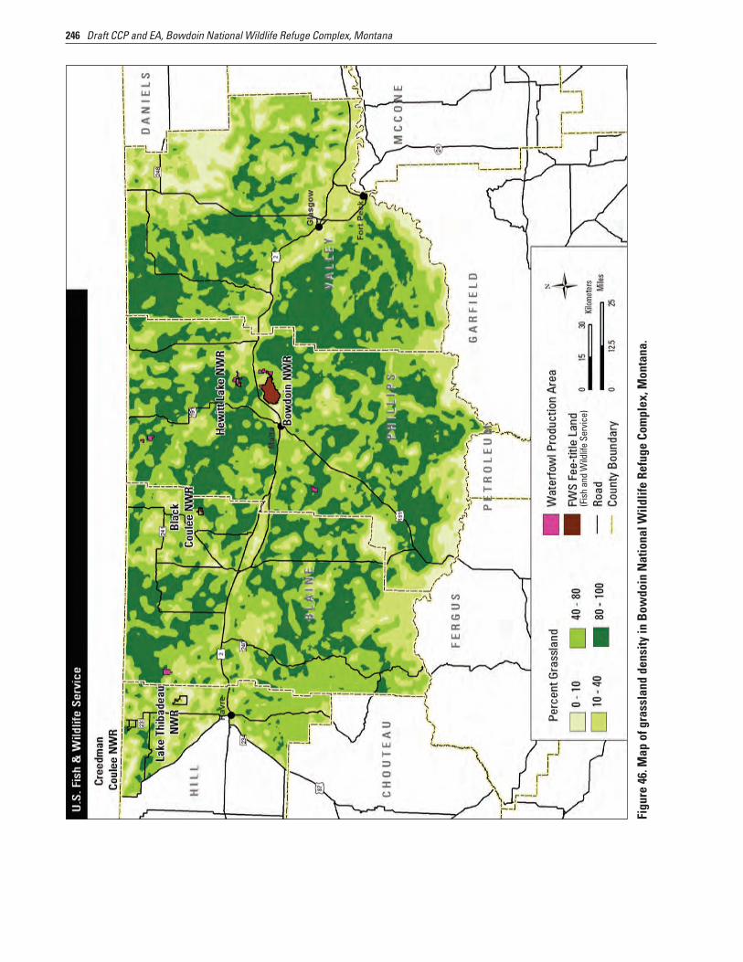
246 Draft CCP and EA, Bowdoin National Wildlife Refuge Complex, Montana
Figu
re 4
6. M
ap o
f gra
ssla
nd d
ensi
ty in
Bow
doin
Nat
iona
l Wild
life
Refu
ge C
ompl
ex, M
onta
na.
(Fis
h an
d W
ildlif
e Se
rvic
e)

247CHAPTER 7–Implementation of the Proposed Action, the Draft CCP
oriti
es in
Bow
doin
Fi
gure
47.
Map
of a
reas
with
hig
h de
nsiti
es o
f wet
land
s an
d gr
assl
ands
for u
se a
s a
deci
sion
mat
rix
to d
eter
min
e pr
otec
tion
pri
Nat
iona
l Wild
life
Refu
ge C
ompl
ex, M
onta
na.
(Fis
h an
d W
ildlif
e Se
rvic
e)
248 Draft CCP and EA, Bowdoin National Wildlife Refuge Complex, Montana
for greater crop production, but in rangelands where wetlands are drained to consolidate water into larger basins for livestock watering.
Since most of the grassland conservation ease-ments protect native prairie, the major enforcement concern is conversion to cropland. While violations involving the conversion of native prairie to crop-land are extremely rare, full restoration of native prairie in these situations is impossible. Neverthe-less, landowners could plant grass in areas they had plowed, which would help them regain compliance with the easement provisions. Enforcement that ensures compliance would be essential to the protec-tion of these habitats. Any haying, mowing, or har-vesting seed before July 15 would be in violation of easement provisions and could cause direct losses to waterfowl and other grassland-nesting birds. While the cutting of hay on native prairie is not common, it is more likely to occur on grassland easements with tamegrass seeding such as those in the Conservation Reserve Program. Enforcement of haying restric-tions would afford another opportunity to meet and visit with landowners and operators. These contacts may serve to remind landowners and operators of the easement provisions and hopefully prevent more serious violations in the future, which would achieve the goal of voluntary compliance.
7.7 Goal for Visitor Services and Cultural Resources
Provide visitors of all abilities with wildlife-dependent recreation, interpretation, and education opportunities that fosters an appre-ciation and understanding of the unique wildlife, plant communities, and cultural resources of the Montana Prairie Pothole Region.
Visitor ServicesThe Bowdoin National Wildlife Refuge Complex manages nearly 85,000 acres of lands and waters, some of which are open for wildlife-dependent and compatible public use (appendix D contains draft compatibility determinations for public uses associ-ated with this draft CCP). Because the refuge com-plex is spread over four counties, it is impossible for Service staff to meet and interact with each visitor that comes to enjoy the habitats, fish, and wildlife found on the refuge complex. There are brochures, signage, and interpretive panels that visitors can use to independently explore and learn about the refuge
complex; nevertheless, there are still visitors who are even unaware that they are on a national wildlife refuge.
Additional programs, staff, and funding would be needed for a broad-based program that reached the maximum number of visitors to achieve the pro-posed goal. Current staff might be able to provide some of the additional opportunities proposed in these objectives and strategies but not without sac-rificing the ability to conduct other visitor, biological, or maintenance programs. Meeting the visitor ser-vices objectives would be contingent on hiring one permanent full-time visitor services specialist, one permanent full-time maintenance worker, and one permanent full-time law enforcement officer.
Hunting ObjectiveContinue to provide hunters with safe, reasonable harvest opportunities with uncrowded conditions, minimal conflicts with other users, and satisfaction with their overall experiences.
Strategies
■■ Continue to provide compatible hunting oppor-tunities for waterfowl and upland game birds on 40 percent (western portion) of Bowdoin Refuge (figure 28 in chapter 4), according to State and Federal regulations.
■■ Continue to require hunters to use approved non-toxic shot for hunting of migratory and upland game birds on Service lands.
■■ Continue to permit compatible hunting oppor-tunities for upland game birds in the waterfowl sanctuary portion of Bowdoin Refuge (figure 28 in chapter 4) as late-season hunting (no sooner than December 1), contingent on waterfowl mi-grating off the refuge when the wetlands freeze. Restrict the first 2 days of this hunt to hunting only by young people.
■■ Continue the hunter registry at Bowdoin Na-tional Wildlife Refuge and expand the form to include extra columns that would allow hunters to describe their hunting experience and satisfac-tion.
■■ Consider conducting limited-draw hunts to ad-dress overcrowding if hunter satisfaction de-creases.
■■ Conduct random surveys on the wetland manage-ment district to determine hunter satisfaction.

249CHAPTER 7–Implementation of the Proposed Action, the Draft CCP
■■ Evaluate future acquisitions for new hunting op-portunities.
■■ Create a public use brochure for Bowdoin Wet-land Management District.
■■ Continue to maintain the accessible boardwalk and hunting blind at the Pearce WPA for hunters with disabilities.
■■ Post changes in hunting regulations, seasons, and bag limits at the hunter kiosk and Bowdoin Ref-uge headquarters, on the refuge complex’s Web site, and through news releases.
■■ Update the hunting regulation sections of the public use brochures as needed.
■■ Use the refuge signage and brochures to provide hunters with information on hunting regulations and where to hunt on the refuge complex to en-sure compliance with public use regulations.
■■ Recruit one permanent, full-time, law enforce-ment officer.
■■ Continue to allow the public, including hunters, to park in designated parking areas on the north end and southeast boundaries of Bowdoin Refuge and to walk through the refuge to access Pearce WPA to the north and Beaver Creek WPA to the east (figure 28 in chapter 4).
■■ Improve public access to compatible, wildlife-dependent activities on Black Coulee National Wildlife Refuge by developing the entrance road and parking for the reservoir.
■■ Close the eastern portion of Bowdoin Refuge to all foot traffic from the beginning of the water-fowl hunting season through at least November 30, or until waterfowl have left the refuge, to pro-vide continued sanctuary. Although the auto tour route would remain open through this portion of the refuge, require visitors to remain on the tour route outside of the hunting areas.
■■ Work with the State to determine the feasibility of providing a limited big game archery hunt on portions of Bowdoin Refuge that are currently open to public use. Address the compatibility of the hunt and the safety of hunters and other refuge visitors.
Black Coulee Pond is one of several ponds that are overgrown with cattail.
Mik
e A
rtm
ann
/ US
FW
S
Rationale. Many people consider hunting to be a legitimate, traditional, recreational use of renew-able natural resources. The National Wildlife Ref-
uge System Act of 1966, other laws, and Fish and Wildlife Service policy permit hunting on a national wildlife refuge when it is compatible with the pur-poses for which the refuge was established and ac-quired. National wildlife refuges exist primarily to safeguard wildlife populations through habitat preservation. The word “refuge” includes the idea of providing a haven of safety for wildlife, and as such, hunting might seem an inconsistent use of the National Wildlife Refuge System. However, habitat that normally supports healthy wildlife populations produces harvestable surpluses that are a renewable resource.
As practiced on Bowdoin National Wildlife Ref-uge Complex, hunting does not pose a threat to the wildlife populations, and in some instances, is neces-sary for sound wildlife management. Harvesting wildlife on the refuge complex is carefully regulated to ensure equilibrium between population levels and wildlife habitat. All lands within the Bowdoin Wetland Management District are open to some form of hunting with the exception of Holm WPA. Closing the eastern half of Bowdoin Refuge to foot traffic during the waterfowl season would provide additional protection and rest for waterbirds and may actually improve hunting on other portions of the refuge. The western portion (40 percent of the refuge) is open to compatible hunting of waterfowl and upland game birds in accordance with State and Federal hunting regulations. The waterfowl sanctu-ary portion of the refuge (60 percent) is only open to late-season hunting (December 1–31) of upland game birds, contingent on when waterfowl migrate
250 Draft CCP and EA, Bowdoin National Wildlife Refuge Complex, Montana
off the refuge due to the freezing of refuge wetlands. These hunting seasons are monitored and enforced to ensure regulations are followed and the provide hunters with a safe, quality experience.
The refuge complex currently has one wildlife refuge specialist with a minimum of 25 percent of their duties committed to collateral law enforce-ment patrols and enforcement. The wildlife refuge specialist’s remaining responsibility is managing the wetland management district: 158 grassland and wetland conservation easements, 1 flowage ease-ment, 4 FmHA easements, 9 waterfowl production areas, and 4 satellite refuges with 29 associated ref-uge and flowage easements. This individual is also responsible for conducting law enforcement activi-ties across the refuge complex. Expansion of hunt-ing and other visitor services programs would be contingent on the ability to recruit one, permanent, full-time law enforcement officer to protect refuge resources and provide the public with a safe experi-ence.
Fishing ObjectiveFollowing State and Federal regulations, continue to allow compatible recreational fishing on Beaver Creek and McNeil Slough WPAs.
Strategies
■■ Continue to require visitors to follow State and Federal regulations for fishing on designated ar-eas within the refuge complex.
■■ Include information on fishing locations and regu-lations in the new brochure for the waterfowl production areas.
■■ Continue to provide anglers information about other fishing opportunities on areas surrounding the refuge complex.
Rationale. Fishing is considered by many to be a legitimate, traditional, recreational use of renewable natural resources. The National Wildlife Refuge System Act of 1966, other laws, and Fish and Wild-life Service policy permit fishing when it is com-patible with the purposes for which the refuge or district was established and acquired. Compatible recreational fishing opportunities are available at McNeil Slough WPA (primarily on the Milk River) and Beaver Creek WPA (primarily on Beaver Creek). The remainder of the wetlands within the district have minimal habitat or do not support har-vestable game fisheries or populations.
Anglers have many exceptional fishing oppor-tunities within 100 miles of Bowdoin Wetland Man-
agement District including fishing at the Nelson Reservoir, Cole Ponds, Milk River, Missouri River, Fort Peck Lake, and stocked ponds and reservoirs on public and private lands (Montana’s Missouri River Country 2007).
Environmental Education and Interpretation Objective 1Continue and expand environmental education pro-grams and activities for adults and students on and off the refuge complex, focusing on the native prairie and wetland habitats and the natural, cultural, and historical resources of the Bowdoin National Wildlife Refuge Complex. Design these programs and activi-ties to develop awareness of and promote advocacy for refuge resources and management activities for more than 500 visitors and students annually.
Strategies
■■ Recruit one permanent, full-time, visitor services specialist.
■■ Develop additional education kits specific to ref-uge programs and resources including field ex-ploration kits (for example, backpacks with field equipment) and field activity pages.
■■ Develop a series of environmental outreach pro-grams with specific themes (such as prairie and wetland conservation and grassland birds) that can be used for on- and off-refuge programs.
■■ Maintain and update a list of available environ-mental education kits and lending library materi-als for teachers.
■■ Every 5 years, facilitate a workshop for local teachers.
■■ Participate annually in at least two community events where the opportunity is available to edu-cate the public about the refuge complex and its resources.
■■ Provide onsite programs for at least six school groups, or 300 students, on the refuge complex per year.
■■ Provide at least three onsite staff-led group pro-grams on the refuge complex per year.
■■ Conduct at least 10 offsite visits to local schools within the wetland management district or with other groups or organizations to present infor-

251CHAPTER 7–Implementation of the Proposed Action, the Draft CCP
mation on the history, purposes, and natural re-sources of the refuge complex.
■■ Host events for International Migratory Bird Day and National Wildlife Refuge Week.
■■ Pursue opportunities to expose middle school, high school, and college students to the field of natural resource management.
■■ Work with partners to develop programs to in-troduce young people to safe, effective, and ethi-cal hunting techniques and methods.
■■ Develop programs for introducing young people to the enjoyment of the outdoors and instilling ethical, safe, and effective skills for observation, identification, and photography of wildlife.
■■ Work with schools and teachers within the wet-land management district to develop programs that support their curriculum objectives.
■■ Pursue grants and other funding sources to sup-port environmental education programs.
Rationale. Environmental education is a process de-signed to teach citizens and visitors, children and adults, the history and importance of conservation and scientific knowledge about the Nation’s natural resources. Through this process, the Service can help develop a citizenry that has the awareness, knowledge, attitudes, skills, motivation, and commit-ment to work cooperatively toward the conservation
of environmental resources. Environmental educa-tion within the Refuge System incorporates onsite, offsite, and distance-learning materials, activities, programs, and products that address the audience’s course of study, refuge purposes, physical attributes, ecosystem dynamics, conservation strategies, and the Refuge System mission.
Highly structured programs do not have the same effect as allowing students to explore on their own. Programs must not be so rigid so that children cannot learn by using their own imaginations and senses and yet achieve a balance that ensures the student learns something new and exciting about the resources they encounter.
Environmental education is among the six compatible, wildlife-dependent recreational uses identified in the Improvement Act. Due to limited staff and resources, the Bowdoin National Wildlife Refuge Complex has been conducting minimal en-vironmental education activities, typically only by invitation from local schoolteachers. Since today’s children are tomorrow’s land stewards, it is essential to help them become aware of the natural world around them and what they can do to help protect and restore it.
Lake Bowdoin in the distance.
© M
icha
el F
orsb
erg
Environmental Education and Interpretation Objective 2Provide additional interpretive opportunities for the public that focus on native prairie and wetland habitats, the refuge complex’s purposes, and natural, cultural, and historical resources. Design these op-portunities to promote awareness of and advocacy
252 Draft CCP and EA, Bowdoin National Wildlife Refuge Complex, Montana
for the National Wildlife Refuge System and the refuge complex’s resources, management challenges, and programs.
Strategies
■■ Recruit one permanent, full-time, visitor services specialist.
■■ Design and install interpretive panels at the accessible wildlife observation stop (number 5) along the auto tour route.
■■ Work with the city of Malta to install an informa-tional kiosk in town that provides refuge informa-tion and directional maps.
■■ Develop a display at the Phillips County museum highlighting the history of the refuge complex.
■■ Expand the visitor contact area at refuge head-quarters into the conference room and add ad-ditional interpretive literature and activities.
■■ Develop a portable refuge-specific display that can be used for programs and events.
■■ Engage partners and challenge cost-share oppor-tunities (such as the local film school) to develop a short refuge film for the refuge Web site and other outreach activities.
■■ Install interpretive panels describing the uses of prescribed fire, grazing, and haying.
■■ Install informational kiosks at the Beaver Creek and McNeil Slough WPAs to interpret wetland management in these areas.
■■ Expand the visitor contact area, providing ac-cess to visitors of all abilities. Use this additional space for improved interpretive displays and more materials.
Rationale. Interpretation is the identification and communication of important messages about nat-ural and cultural resources to diverse audiences. Interpretation is designed to reveal relationships about the nature, origin, and purpose of a resource, landscape, or site in a way that forges connections between the interests of the audience and meanings inherent in the resource (National Association for Interpretation (no date). As a resource management tool, interpretation is designed to develop under-standing—through understanding, appreciation—and through appreciation, protection (National Park Service 2009).
Interpretation is one of the six compatible, wildlife-dependent, recreational uses identified in the Improvement Act. Due to limited staff and re-sources, the Bowdoin National Wildlife Refuge Com-plex has been conducting minimal interpretation activities. It is essential to help the public become aware of the natural world around them and what they can do to help protect and restore it.
Wildlife Observation and Photography ObjectiveProvide increased opportunities for wildlife obser-vation and photography that enhance the visitor experience and encourages an appreciation and con-nection to the northern prairie.
Strategies
■■ Recruit one permanent, full-time, visitor services specialist.
■■ Maintain year-round opportunities for wildlife observation and photography along the existing auto tour route on Bowdoin Refuge including the accessible nature trails. Develop an accessible wildlife observation site with spotting scopes and an expanded parking area at stop number 5 along the auto tour route (figure 28 in chapter 4).
■■ Maintain the refuge complex’s two accessible photography blinds at Bowdoin Refuge and Pearce WPA.
■■ Install a remote camera for observing grouse lek activities.
■■ Provide regularly scheduled wildlife observation tours.
■■ Update the Bowdoin Refuge brochures for known mammal, reptile, and amphibian species.
■■ Notify the local media of opportunities to view migrating birds, particularly unique species.
■■ Close the east end of Bowdoin Refuge to all foot traffic at the start of the waterfowl-hunting sea-son (at least through November 30) or until wa-terfowl depart the refuge, to provide sanctuary areas for migratory waterfowl and shorebirds (figure 28 in chapter 4). Keep the auto tour route open but require visitors to remain on the auto tour route in designated sanctuary areas.
■■ Encourage visitors to provide their observations and experiences at the end of a visit through

253CHAPTER 7–Implementation of the Proposed Action, the Draft CCP
contacts in the visitor contact area and during random field encounters, requesting they provide feedback in the brochures and through the refuge complex’s Web site.
Rationale. Most visitors that come to the Bowdoin National Wildlife Refuge Complex are here to view and photograph wildlife and scenery—more than 25,000 visitors each year. Wildlife observation and photography are among the six, wildlife-dependent, recreational uses that have been found compatible on the refuge complex. Wildlife observation often serves as the foundation for an individual’s environ-mental ethics. This happens when people begin to appreciate and care about the wildlife they are able to enjoy and experience firsthand; they take this appreciation and awareness back to their own com-munities and backyards.
The proposed enhancements to the photography and wildlife-viewing areas within the refuge com-plex would not only enhance the visitor’s experience and opportunity to view and photograph wildlife but also provide a connection to the area’s unique habitat and wildlife. This connection may result in a greater understanding and appreciation of the refuge com-plex and the important grassland and wetland habi-tat protected within its boundaries.
These uses have the potential to negatively affect resources, particularly use by visitors who are per-mitted to explore the refuge complex on foot. Stud-ies have shown that individuals or groups walking disturb wildlife, particularly waterfowl, even more than vehicles. To minimize some of these effects at the most popular area for wildlife viewing—Bowdoin Refuge—the east end of the refuge would be closed to foot traffic during the waterfowl-hunting season. This would provide an undisturbed resting area for waterfowl and other waterbirds until hunting season ends around November 30. Visitors could still view these birds from the auto tour route but would need to remain in their vehicles in designated sanctuary areas.
Cultural ResourcesThe refuge complex has some historical structures, including a few dams and spillways. In addition, there are remnants of prehistoric use—tipi rings have been found throughout the refuge complex.
Cultural Resources Objective 1Through partnerships, continue to develop a com-prehensive cultural resource inventory of the refuge complex and preserve and protect all known cultural resources while ensuring future activities comply
with section 106 of the National Historic Preserva-tion Act.
Petroglyph
Car
men
Lun
a / U
SF
WS
Strategies
■■ Work with the Service’s zone archaeologist and contractors, local tribes, and universities to con-tinue developing the cultural resources inventory.
■■ Document all cultural resource sites found during refuge activities.
■■ Work with archaeological staffs of the Service and the State Historic Preservation Office to ensure refuge complex activities comply with section 106 of the National Historic Preservation Act.
RationaleIdeally, a comprehensive inventory would help en-sure the protection of cultural resources. Through-out the life of this 15-year plan, the refuge complex staff would work with partners and the regional ar-chaeologist and staff to begin documenting cultural sites.
Federal laws and policies mandate the identifica-tion and protection of cultural resources on Federal lands. Section 106 of the National Historic Preser-vation Act requires Federal agencies to consider the effects on cultural resources before conducting any Federal action. Without a complete inventory, the refuge complex’s identification of all cultural resources is likely incomplete. Nevertheless, the law requires all Federal activities that have the poten-tial to impact cultural resources be evaluated. Until the inventory is completed, the staff would continue to work with the regional archaeologist to evaluate projects with the potential to have impacts, on a case-by-case basis.

254 Draft CCP and EA, Bowdoin National Wildlife Refuge Complex, Montana
Cultural Resources Objective 2Improve public awareness and appreciation for the cultural resources and history of the refuge complex and the northern prairies while creating a greater understanding of this history’s connection to the natural resources of the area.
Strategies
■■ Work with the city of Malta to install an infor-mational kiosk in the community that provides information on the cultural resources of the area and the history of the refuge complex.
■■ Include cultural resource interpretation in the expanded visitor contact area.
Rationale. Cultural resources interpretation com-municates important messages about the area’s his-tory, context, and resources to diverse audiences. Refuge complex lands have a rich history of Native American and Euro-American presence. Historical structures include the stone pillars at the entrance into Bowdoin Refuge, which were built by workers in the Works Progress Administration.
As a resource management tool, interpretation is designed to develop understanding; through un-derstanding, appreciation; and through appreciation, protection (National Park Service 2009). Working with the city of Malta to interpret these resources and create a display in the city would generate addi-tional interest and understanding of these resources while encouraging people to visit the refuge to learn more.
7.8 Goal for PartnershipsMaintain and expand partnerships that preserve, restore, and enhance healthy and productive prairie/wetland complexes on Bowdoin National Wildlife Refuge and the wetland management district.
Public, Government, and Industry PartnersPartnerships are vital to achieving the Service’s mis-sion. Present and future conservation activities con-ducted on Service lands and conservation easements have the potential to positively influence adjoining landowners and surrounding communities.
Partnership Objective 1Continue to participate in and expand partnerships that contribute to the understanding and conser-vation, restoration, and enhancement of diverse, healthy, productive grassland and wetland systems and the goals of the National Wildlife Refuge Sys-tem.
Strategies
■■ Develop a Friends group to support the refuge complex’s goals and programs.
■■ Continue to support the Partners for Fish and Wildlife Program work on private lands.
■■ Continue working with Montana Fish, Wildlife & Parks to conduct habitat improvement projects in areas open to hunting.
■■ Work with other Federal land managers to de-termine if their infrastructure and management actions could be used to enhance the refuge com-plex’s wetland system.
■■ Cooperate with the weed boards within the four counties covering the refuge complex.
■■ Continue to cooperate with neighboring commu-nities, counties, landowners, and nongovernmen-tal organizations to accomplish projects of mutual interest.
■■ Coordinate with universities to develop an ongo-ing program of graduate projects that could be used to research and resolve refuge management issues.
■■ Continue expanding partnerships with the coun-ties to improve roads that provide public access to the refuge complex.
Rationale. Regular communication with partners, various groups, communities, and individuals through meetings, local events, and activities would not only help garner support for refuge management activities and the National Wildlife Refuge System, but also allow managers to hear and understand their concerns. This open dialog and involvement with partners would help build and maintain support for the refuge complex’s programs. Furthermore, many of the Bowdoin National Wildlife Refuge Com-plex’s wildlife, habitat, and public use programs and habitat projects could not continue without the fund-ing and support from partners.
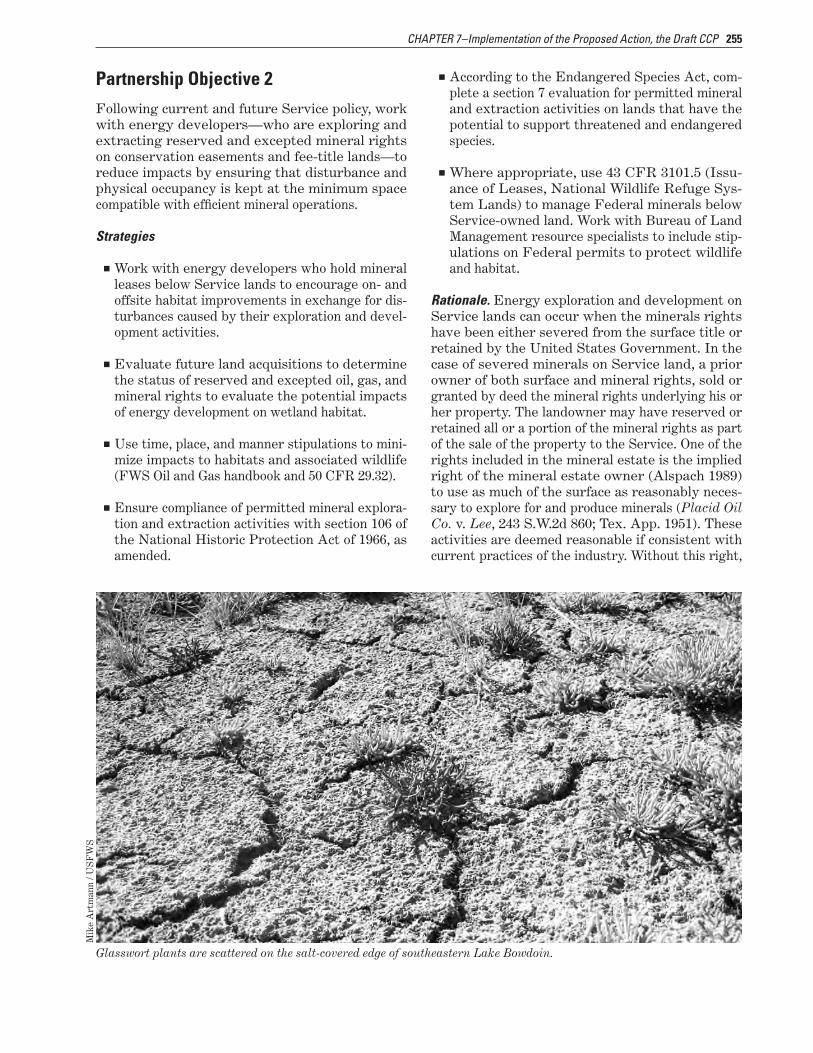
255CHAPTER 7–Implementation of the Proposed Action, the Draft CCP
Partnership Objective 2Following current and future Service policy, work with energy developers—who are exploring and extracting reserved and excepted mineral rights on conservation easements and fee-title lands—to reduce impacts by ensuring that disturbance and physical occupancy is kept at the minimum space compatible with efficient mineral operations.
Strategies
■■ Work with energy developers who hold mineral leases below Service lands to encourage on- and offsite habitat improvements in exchange for dis-turbances caused by their exploration and devel-opment activities.
■■ Evaluate future land acquisitions to determine the status of reserved and excepted oil, gas, and mineral rights to evaluate the potential impacts of energy development on wetland habitat.
■■ Use time, place, and manner stipulations to mini-mize impacts to habitats and associated wildlife (FWS Oil and Gas handbook and 50 CFR 29.32).
■■ Ensure compliance of permitted mineral explora-tion and extraction activities with section 106 of the National Historic Protection Act of 1966, as amended.
■■ According to the Endangered Species Act, com-plete a section 7 evaluation for permitted mineral and extraction activities on lands that have the potential to support threatened and endangered species.
■■ Where appropriate, use 43 CFR 3101.5 (Issu-ance of Leases, National Wildlife Refuge Sys-tem Lands) to manage Federal minerals below Service-owned land. Work with Bureau of Land Management resource specialists to include stip-ulations on Federal permits to protect wildlife and habitat.
Glasswort plants are scattered on the salt-covered edge of southeastern Lake Bowdoin.
Mik
e A
rtm
ann
/ US
FW
S
Rationale. Energy exploration and development on Service lands can occur when the minerals rights have been either severed from the surface title or retained by the United States Government. In the case of severed minerals on Service land, a prior owner of both surface and mineral rights, sold or granted by deed the mineral rights underlying his or her property. The landowner may have reserved or retained all or a portion of the mineral rights as part of the sale of the property to the Service. One of the rights included in the mineral estate is the implied right of the mineral estate owner (Alspach 1989) to use as much of the surface as reasonably neces-sary to explore for and produce minerals (Placid Oil Co. v. Lee, 243 S.W.2d 860; Tex. App. 1951). These activities are deemed reasonable if consistent with current practices of the industry. Without this right,
256 Draft CCP and EA, Bowdoin National Wildlife Refuge Complex, Montana
the reservation of minerals would be worthless to the grantee or reserver.
State laws overseeing the activities of explora-tion and production of minerals give some protec-tion to the surface owner, because both parties must agree on compensation for surface damages (State of Montana 2009). Federal law for mineral rights reserved and excepted on Service land requires per-sons holding mineral rights to the greatest extent practicable conduct operations in such a manner as to prevent damage, erosion, pollution or contamina-tion to the lands, water, facilities and vegetation of the area (50 CFR 29.32). In addition, physical oc-cupancy of the area must be kept to the minimum space compatible with the conduct of efficient min-eral operations. The Mineral Leasing Act of 1920 is the Federal law that authorizes the leasing of min-eral rights owned by the United States Government. These Federal minerals are leased under the author-ity of the Bureau of Land Management. Regulations pertaining to the leasing and extraction of Federal minerals are found in 43 CFR.
Conservation easement contracts and waterfowl production areas are purchased subject to all valid existing mineral rights. In these situations, min-eral rights are the dominant estate, and the rights of the surface owner or easement contract are the servient estate. There are several instances in the refuge complex where the Service owns surface title over Federal minerals. In most of these cases, the Federal minerals were leased before the Service obtaining ownership of the surface estate. The mineral lessee as afforded in the lease has the authority to occupy Service land and extract the minerals. When the Federal minerals have not been leased, section 3101.5–1 of 43 CFR states that there shall be no oil and gas mineral leasing on lands within a national wildlife refuge to give complete protection to the wildlife populations and habitats for which these lands were established. The exception to this rule is when drainage of the Federal minerals can be documented. To protect Federal minerals from drainage the Bureau of Land Management requests leasing recommendations from the Service. As a rule, the Service recommends a stipulation of no
surface occupancy be added to the lease. This pro-tects the Service’s surface rights but allows for the Federal mineral extraction from surfaces outside the boundaries of a refuge or waterfowl production area.
Regardless of the circumstances, the Service would work closely with the mineral producer and Bureau of Land Management specialists to impose reasonable restrictions or conditions required to minimize adverse effects to wildlife and habitat resources (42 CFR 3101.1–2). Stipulations used to protect the resource would address time, place, and manner of activities. Guidance for handling mineral exploration and development is found in the Moun-tain–Prairie Region’s “Fish and Wildlife Service Handbook on Management of Oil and Gas Activities on Fish and Wildlife Service Lands” (U.S. Fish and Wildlife Service 2009a).
7.9 Goal for OperationsPrioritize for wildlife first and emphasize the protection of trust resources in the utilization of staff, funding, partnerships, and volunteer programs.
StaffThe staff of the Bowdoin Refuge Complex has a
huge challenge in managing almost 85,000 acres of Service lands scattered throughout a four-county,
17,183-square-mile area. Current staff at the refuge consists of five permanent full-
time employees. Table 18 shows the current staff and proposed additional staff required to fully implement the
CCP. If all positions were funded, refuge staff would be able to carry out all
aspects of this CCP, which would provide maximum benefit to wildlife, improve facilities,
and provide for public use. Projects that have ade-quate funding and staffing would receive priority for accomplishment. Staffing and funding are requested for the 15-year life of this CCP.
Staff ObjectiveIn addition to current employees, recruit additional staff and volunteers needed to fully carry out the proposed actions in this draft CCP including moni-toring, inventory, and research.
Prairie Coneflower© Cindie Brunner
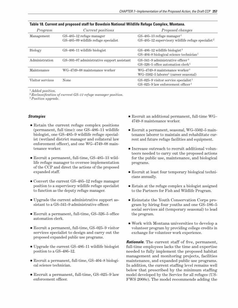
257CHAPTER 7–Implementation of the Proposed Action, the Draft CCP
Table 18. Current and proposed staff for Bowdoin National Wildlife Refuge Complex, Montana.Program Current positions Proposed changes
Management GS–485–12 refuge manager GS–485–13 refuge manager1
GS–485–09 wildlife refuge specialist GS–485–12 supervisory wildlife refuge specialist2
Biology GS–486–11 wildlife biologist GS–486–12 wildlife biologist3
GS–404–8 biological science technician1
Administration GS–303–07 administrative support assistant GS–341–9 administrative officer 3
GS–326–5 office automation clerk1
Maintenance WG–4749–08 maintenance worker WG–4749–8 maintenance worker1
WG–3502–5 laborer1 (career seasonal)
Visitor services None GS–025–9 visitor service specialist1
1GS–025–9 law enforcement officer
1 Added position.2 Reclassification of current GS–12 refuge manager position.3 Position upgrade.
Strategies
■■ Retain the current refuge complex positions (permanent, full time): one GS–486–11 wildlife biologist, one GS–485–9 wildlife refuge special-ist (wetland district manager and collateral law enforcement officer), and one WG–4749–08 main-tenance worker.
■■ Recruit a permanent, full-time, GS–485–13 wild-life refuge manager to oversee implementation of the CCP and direct the actions of the proposed expanded staff.
■■ Convert the current GS–485–12 refuge manager position to a supervisory wildlife refuge specialist to function as the deputy refuge manager.
■■ Upgrade the current administrative support as-sistant to a GS–341–9 administrative officer.
■■ Recruit a permanent, full-time, GS–326–5 office automation clerk.
■■ Recruit a permanent, full-time, GS–025–9 visitor services specialist to design and carry out the proposed expanded public use programs.
■■ Upgrade the current GS–486–11 wildlife biologist position to a GS–486–12.
■■ Recruit a permanent, full-time, GS–404–8 biologi-cal science technician.
■■ Recruit a permanent, full-time, GS–025–9 law enforcement officer.
■■ Recruit an additional permanent, full-time WG–4749–8 maintenance worker.
■■ Recruit a permanent, seasonal, WG–3502–5 main-tenance laborer to maintain and rehabilitate cur-rent and future refuge facilities and equipment.
■■ Increase outreach to recruit additional volun-teers needed to carry out the proposed actions for the public use, maintenance, and biological programs.
■■ Recruit at least four temporary biological techni-cians annually.
■■ Retain at the refuge complex a biologist assigned to the Partners for Fish and Wildlife Program.
■■ Reinstate the Youth Conservation Corps pro-gram by hiring four youths and one GS–186–5 social services aid (temporary seasonal) to lead the program.
■■ Work with Montana universities to develop a volunteer program by providing college credits in exchange for volunteer work experience.
Rationale. The current staff of five, permanent, full-time employees lacks the time and expertise needed to fully implement the proposed habitat management and monitoring projects, facilities maintenance, and expanded public use programs. In addition, the current staffing level remains well below that prescribed by the minimum staffing model developed by the Service for all refuges (US-FWS 2008c). The model recommends adding the
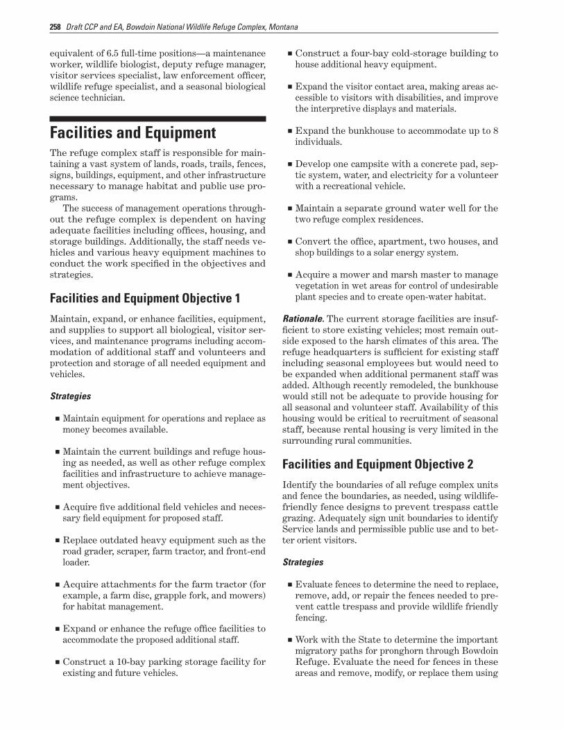
258 Draft CCP and EA, Bowdoin National Wildlife Refuge Complex, Montana
equivalent of 6.5 full-time positions—a maintenance worker, wildlife biologist, deputy refuge manager, visitor services specialist, law enforcement officer, wildlife refuge specialist, and a seasonal biological science technician.
Facilities and EquipmentThe refuge complex staff is responsible for main-taining a vast system of lands, roads, trails, fences, signs, buildings, equipment, and other infrastructure necessary to manage habitat and public use pro-grams.
The success of management operations through-out the refuge complex is dependent on having adequate facilities including offices, housing, and storage buildings. Additionally, the staff needs ve-hicles and various heavy equipment machines to conduct the work specified in the objectives and strategies.
Facilities and Equipment Objective 1Maintain, expand, or enhance facilities, equipment, and supplies to support all biological, visitor ser-vices, and maintenance programs including accom-modation of additional staff and volunteers and protection and storage of all needed equipment and vehicles.
Strategies
■■ Maintain equipment for operations and replace as money becomes available.
■■ Maintain the current buildings and refuge hous-ing as needed, as well as other refuge complex facilities and infrastructure to achieve manage-ment objectives.
■■ Acquire five additional field vehicles and neces-sary field equipment for proposed staff.
■■ Replace outdated heavy equipment such as the road grader, scraper, farm tractor, and front-end loader.
■■ Acquire attachments for the farm tractor (for example, a farm disc, grapple fork, and mowers) for habitat management.
■■ Expand or enhance the refuge office facilities to accommodate the proposed additional staff.
■■ Construct a 10-bay parking storage facility for existing and future vehicles.
■■ Construct a four-bay cold-storage building to house additional heavy equipment.
■■ Expand the visitor contact area, making areas ac-cessible to visitors with disabilities, and improve the interpretive displays and materials.
■■ Expand the bunkhouse to accommodate up to 8 individuals.
■■ Develop one campsite with a concrete pad, sep-tic system, water, and electricity for a volunteer with a recreational vehicle.
■■ Maintain a separate ground water well for the two refuge complex residences.
■■ Convert the office, apartment, two houses, and shop buildings to a solar energy system.
■■ Acquire a mower and marsh master to manage vegetation in wet areas for control of undesirable plant species and to create open-water habitat.
Rationale. The current storage facilities are insuf-ficient to store existing vehicles; most remain out-side exposed to the harsh climates of this area. The refuge headquarters is sufficient for existing staff including seasonal employees but would need to be expanded when additional permanent staff was added. Although recently remodeled, the bunkhouse would still not be adequate to provide housing for all seasonal and volunteer staff. Availability of this housing would be critical to recruitment of seasonal staff, because rental housing is very limited in the surrounding rural communities.
Facilities and Equipment Objective 2Identify the boundaries of all refuge complex units and fence the boundaries, as needed, using wildlife-friendly fence designs to prevent trespass cattle grazing. Adequately sign unit boundaries to identify Service lands and permissible public use and to bet-ter orient visitors.
Strategies
■■ Evaluate fences to determine the need to replace, remove, add, or repair the fences needed to pre-vent cattle trespass and provide wildlife friendly fencing.
■■ Work with the State to determine the important migratory paths for pronghorn through Bowdoin Refuge. Evaluate the need for fences in these areas and remove, modify, or replace them using
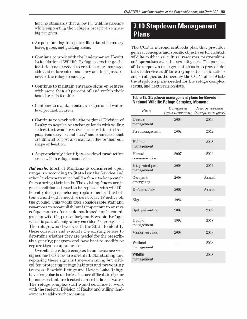
259CHAPTER 7–Implementation of the Proposed Action, the Draft CCP
fencing standards that allow for wildlife passage while supporting the refuge’s prescriptive graz-ing program.
■■ Acquire funding to replace dilapidated boundary fence, gates, and parking areas.
■■ Continue to work with the landowner on Hewitt Lake National Wildlife Refuge to exchange the fee-title lands needed to create a more manage-able and enforceable boundary and bring aware-ness of the refuge boundary.
■■ Continue to maintain entrance signs on refuges with more than 40 percent of land within their boundaries in fee title.
■■ Continue to maintain entrance signs on all water-fowl production areas.
■■ Continue to work with the regional Division of Realty to acquire or exchange lands with willing sellers that would resolve issues related to tres-pass, boundary “round-outs,” and boundaries that are difficult to post and maintain due to their odd shape or location.
■■ Appropriately identify waterfowl production areas within refuge boundaries.
Rationale. Most of Montana is considered open range, so according to State law the Service and other landowners must build a fence to keep cattle from grazing their lands. The existing fences are in good condition but need to be replaced with wildlife-friendly designs, including replacement of the bot-tom strand with smooth wire at least 18 inches off the ground. This would take considerable staff and resources to accomplish but is important to ensure refuge complex fences do not impede or harm mi-grating wildlife, particularly on Bowdoin Refuge, which is part of a migratory corridor for pronghorn. The refuge would work with the State to identify these corridors and evaluate the existing fences to determine whether they are needed for the prescrip-tive grazing program and how best to modify or replace them, as appropriate.
Overall, the refuge complex boundaries are well signed and visitors are oriented. Maintaining and replacing these signs is time-consuming but criti-cal for protecting refuge habitats and preventing trespass. Bowdoin Refuge and Hewitt Lake Refuge have irregular boundaries that are difficult to sign or boundaries that are located across bodies of water. The refuge complex staff would continue to work with the regional Division of Realty and willing land-owners to address these issues.
7.10 Stepdown Management Plans
The CCP is a broad umbrella plan that provides general concepts and specific objectives for habitat, wildlife, public use, cultural resources, partnerships, and operations over the next 15 years. The purpose of the stepdown management plans is to provide de-tails to Service staff for carrying out specific actions and strategies authorized by the CCP. Table 19 lists the stepdown plans needed for the refuge complex, status, and next revision date.
Table 19. Stepdown management plans for Bowdoin National Wildlife Refuge Complex, Montana.
Plan Completed (year approved)
New or revision (completion year)
Disease management
2006 2013
Fire management 2002 2012
Habitat management
— 2018
Hazard communication
2007 2012
Integrated pest management
2003 2014
Occupant emergency
2008 Annual
Refuge safety 2007 Annual
Sign 1984 —
Spill prevention 2007 2012
Upland management
1992 2018
Visitor services 2008 2018
Wetland management
— 2018
Wildlife management
— 2018

260 Draft CCP and EA, Bowdoin National Wildlife Refuge Complex, Montana
7.11 Research, Monitoring, and Evaluation
Appendix D contains the draft compatibility de-termination for research and monitoring. Further-more, the Service proposes to most efficiently deal with the uncertainty surrounding habitat manage-ment with adaptive resource management (figure 48) (Holling 1978, Kendall 2001, Lancia et al. 1996, Walters and Holling 1990). This approach provides a framework within which objective decisions can be made and the uncertainty surrounding those deci-sions reduced. The key components of an adaptive resource management plan, such as this draft CCP and proposed stepdown plans, follow:
■■ Clearly defined management goals and objectives
■■ A set of management actions with associated un-certainty as to their outcomes
■■ A suite of models representing various alterna-tive working hypotheses describing the response of species or communities of interest
■■ Monitoring and assessment of the response of target organisms
■■ Use of monitoring and assessment information to direct future decisionmaking through the selec-tion of a best model
The first three components—goals, actions, and models—are largely defined before initiation of an
adaptive resource management plan. The latter two components, monitoring and directed decisionmak-ing, compose a repetitive process whereby, each year, the predictive ability of models are tested against what was observed during monitoring. This may result in a new best model, greater support for the existing best model, or new models constructed from emerging hypotheses. In this way, manage-ment can evolve as more information about the ref-uge complex is gained and uncertainty is reduced.
Development of adaptive resource management plans for habitat management would allow the ref-uge complex staff to “learn by doing,” while focusing on management objectives. Knowledge gained from assessing management actions is as integral to the process as the management actions themselves. This emphasis on gaining knowledge about the refuge complex creates a situation whereby the staff can re-fine its habitat management with feedback between management and assessment.
Figure 48. Adaptive management process.
7.12 Plan Amendment and Revision
The Service will annually review the final CCP to determine the need for revision. A revision would occur if and when significant information became available such as a change in ecological conditions. Revisions to the CCP and the stepdown manage-ment plans would be subject to public review and compliance with the National Environmental Policy Act. At a minimum, the Service would evaluate the plan every 5 years and revise it after 15 years.