CHAPTER 7 Resource Acquisition - Princeton University - Home
20
CHAPTER 7 Resource Acquisition
Transcript of CHAPTER 7 Resource Acquisition - Princeton University - Home
CHAPTER 7
Resource Acquisition
contentsPage
Introduction **** **** ** be** *, *O** 238
The Evolution of Leasing and Land Exchange. 235
Leasing Programs ● .*****@***.,*.,*****,* 237
Land Exchanges . . . . . . . . . . . . . . . . . . . . .. ..241
The Adequacy of Private Lands.... ........241
Present and Potential Projects onPrivate Land . . . . . . . ● . . . . . . . . . . . . . , . . . 2 4 4
Present and Potential Projects onFederal Land.... . . . . . . . . . . . . . . . . . . . . . 246
Is More Federal Land Needed? . ...........249
Policies ● ****, ** , * . . * . . * ,** , * ,* . ,* . , 250
Chapter 7 References . . . . , . . . . . , . . . . . . . . . 2 5 2
List of Tables
Table No. Page31. Tracts Offered Under the Prototype Oil
Shale Leasing Program . . . . . . . . . . . . . . 240
Page32. Distribution of the Oil Shale Resources in
Colorado and Utah. . . . . . . . . . . . . . . . . . 24433. Estimated Shale Oil Production by 1990
in Response to Various Federal Actions. 250
List of Figures
Figure No. Page54. Ownership of the Oil Shale Resources of
the Green River Formation . . . . . . . . . . . 23555. Locations of the Tracts Offered for
Lease Under the Prototype Program . . . . 23956. Privately Owned Tracts in the Piceance
Basin. ... ... ... ... ... ... .....,.. 24357. Thickness of the Oil Shale Deposits in the
Piceance Basin That Yield at Least 25gal/tonof Shale Oil. . . . . . . . . . . . . . . . . . 245
58. Location of the Sodium Mineral Depositsin the Piceance Basin . . . . . . . . . . . . . . . . 246

CHAPTER 7
Resource Acquisition
IntroductionOn May 27, 1980, the Department of the Interior (DOI) announced several oil shale decisions. Up to
four new tracts will be leased under the Prototype Program and preparations started for a permanent leas-ing program. At least one multimineral tract will be included in the renewed Prototype Program. Land ex-changes will not be given special emphasis, and no decision will be made to settle mining claims until theSupreme Court rules on Andrus v. Shell Oil (the oil shale mining claims discovery standard case). [Note:This case was decided on June 2,1980 (No. 78-1815).] The administration will propose to Congress leg-islation to give DOI the authority to grant leases bigger than the present statutory limitation of 5,120acres, to provide for offlease disposal of shale and siting of facilities, and to allow the holding of a max-imum of four leases nationwide and two per State. -
The resources of the Green River formationare owned by the Federal and State govern-ments, by Indian tribes, and by numerous pri-vate parties. (See figure 54. ) Overall, the Fed-eral Government owns about 70 percent ofthe land surface, which overlies about 80 per-cent of the resources. The Federal land con-tains the thickest and richest oil shale de-posits and essentially all of the large depositsof sodium minerals. About 20,000 acres (lessthan 1 percent) of the Federal land has beenallocated for private development throughthe Prototype Oil Shale Leasing Program. Inthe future, it may be necessary to involvemore public land for either private or govern-mental development, if certain technologiesare to be tested or if a large industry is to beestablished rapidly. Releasing this landwould be affected by the laws that governleasing and land exchange, by unpatentedmining claims over most of the Federal land,and by other factors.
This chapter deals with the issues sur-rounding the use of Federal oil shale land.The following subjects are discussed:
● the possible need for committing morepublic land;
Figure 54.—Ownership of the Oil Shale Landsof the Green River Formation
PICEANCE BASIN(COLORADO)
e
PRIVATEFEEzl~.
FEDERAL 79-.
UINTA BASIN(UTAH)
INDIAN 8%
B
PRIVATE FEE 9%
STATE 6%
FE DE FiAL 77°.
GREEN RIVER BASIN WASHAKIE BASIN(WYOMING) WYOMING-COLORADO)
@sATE%@’’’”o”S O U R C E M a p of the Ma/or 0// Shale H o / d / r i g s —Co/orado, Wyom/ng Utah,
Denver, Colo Cameron Engineers, Inc , January 1976
● leasing and land exchange programsand their problems; and
● options for involving more Federal land.
The Evolution of Leasing and Land ExchangeThe legal framework that governs the use both complex and unsettled. It incorporates a
of public land for oil shale development is series of laws and policies dating back two
235
236 . An Assessment of 0il Shale Technologies
centuries that reflect conflicting philosophiesabout the role of the Federal Government astrustee of the public land.
The Continental Congress created the pub-lic domain from lands ceded to the new Con-federation by the individual States. In 1788,the Constitution granted Congress the powerto dispose of the public domain (including sur-face, mineral, and other rights) for the com-mon benefit of all the States. By 1850, thepublic domain extended to the Pacific coast,including the oil shale lands in Colorado,Utah, and Wyoming. The Preemption Act of1841 and the 1846 Lead Mines Statute au-thorized the transfer of public lands to pri-vate parties, and the Homestead Act of 1862allowed settlement of Federal lands in theWest for agricultural purposes. Some tractsalong streams in the Piceance Basin were ac-quired by settlers under this Act. The MiningLaw of 1866 declared the mineral lands of thepublic domain to be free to exploration andopen to appropriation by those prospectorswho found “lode-type” deposits on the land.“Placer” deposits were excluded under thisAct but were subsequently opened to appro-priation under the Placer Act of 1870. *
The Mining Law of 1872 combined, re-vised, and augmented the 1866 and 1870laws, and subsequently governed disposal ofall minerals that are not otherwise explicitlycovered by other legislation. Prospecting wasrecognized as a statutory right. Upon locatinga valuable mineral, a prospector could:
● stake a claim encompassing all or part ofthe deposit;
● develop the deposit;● mine, process, and sell the minerals; and● obtain ownership to the land’s surface
and its mineral values by paying from$2.50 to $5.00/acre, by performing about$500 worth of development work on theclaim, and by carrying out at least $100per year of “assessment” work until thetime that ownership was transferred bya legal document called a patent.
*A lode deposit is confined by rock in the place where it wasoriginally formed. Placer deposits are lode deposits that havebeen broken down, transported, and redeposited in alluvialsediment as a result of exposure to flowing water or ice.
The Secretary of the Department of the Inte-rior (DOI) was given authority to enforce theprovisions of the 1872 Mining Law and tooversee the filing of claims and the grantingof patents. The Petroleum Placer Act of 1897added “lands containing petroleum or othermineral oils” to those subject to the locationand patenting provisions of the 1872 MiningLaw. This action led to a flood of claims for oiland gas reserves, and large areas of publicland were transferred to private hands as aresult.
In the early 20th century, the philosophy offree exploration and occupation of the publicdomain came under scrutiny because of therise of the conservation movement and con-cern over the dwindling supply of strategicmaterials, including oil. This led to two ac-tions:
●
●
President Theodore Roosevelt’s execu-tive withdrawals of public lands thatcontained coal, timber, oil, water, andother essential resources; andDOI’s stricter enforcement of its re-quirements for granting of patents formining claims.
President Roosevelt’s withdrawals were pro-tested in Congress, especially by representa-tives of the Western States, but Presidentialauthority for such withdrawals was subse-quently upheld by the Supreme Court. In l909and 1910, President Taft withdrew the re-maining public domain from appropriation byoil and gas claims. More controversy ensued,and in 1910, at President Taft’s request, Con-gress passed the General Withdrawal Act—The Pickett Act—which authorized the Presi-dent to withdraw public lands by Executiveorder from settlement, location, sale, or otherentry. The withdrawals were to be temporaryand could only be made for the purpose ofevaluating the land for water powersites, ir-rigation, classification, or other public uses.All lands thus withdrawn would remain openfor exploration, discovery, and appropriationunder those provisions of the Mining Law of1872 that applied to metalliferous (metal-bearing) ores.

Ch. 7–Resource Acquisition “ 237
In 1914, Congress severed known fuel andfertilizer mineral rights from the rights to thesurface of lands appropriated for agricultur-al uses. The Stockraising Act of 1916 re-served to the Government all mineral rights.
The Mining Law and the other land-man-agement laws had little effect on oil shaleprior to 1916 because interest in the mineralwas negligible. However, in 1914, the U.S.Geological Survey began investigating the oilshale deposits to determine their potential foryielding fuels. Publication of the results in
1916 coincided with predictions of wide-spread fuel shortages as a result of diminish-ing petroleum reserves. Based on informalrepresentations that oil shale would betreated as a locatable mineral under thePetroleum Placer Act of 1897, more than10,000 claims of 160 acres each were filedbefore 1920. Filing for oil shale claims wasended in 1920 with the passage of the Miner-al Leasing Act. Also in 1920, DOI determinedthat oil shale had been a locatable mineral.Questions related to the valid location andmaintenance of these claims became a sourceof contention that has endured to the present.
Leasing ProgramsThe Mineral Leasing Act of 1920 ended the
process of claiming Federal land for petro-leum, gas, coal, oil shale, phosphate, andsodium minerals. However, private firmscould be given an opportunity to developthese minerals through leasing programs ad-ministered by DOI. The Secretary of the In-terior was required to assess annual rentalsof 50 cents per leased acre, and the maximumsize of an oil shale lease tract was limited to5,120 acres (8 mi2). No individual or firmcould hold more than this acreage underlease. * Except for these provisions, the Sec-retary was given broad discretionary powersto select lease tracts and to shape the termsof development leases. Five oil shale lease ap-plications were filed with DOI after 1920.Three leases were issued, but all were subse-quently canceled.
In the early 1920’s, during the Harding ad-ministration, Secretary of the Interior Fallwas alleged to have accepted bribes from anoil company in consideration of noncompeti-tive leasing of Naval Petroleum Reserve No.3—the Teapot Dome field in Wyoming. In1930, during the era of caution that followedthe Teapot Dome scandals, DOI’s Solicitorsuggested that oil shale lands be withdrawnfrom leasing because shale oil was too expen-
*Shares in several leases could be held, but the total areacovered by the shares could not exceed 5,120 acres.
sive to produce compared with conventionalpetroleum, and therefore any additional leas-ing could only result in speculation, The sug-gestion was adopted by the Secretary andtransmitted to President Hoover, who issuedExecutive Order 5327, which withdrew theoil shale lands from leasing under the Miner-al Leasing Act. The order “temporarily” re-served the lands for the purpose of “investi-gation, examination, and classification, ” asrequired by the Pickett Act under which itwas promulgated.
Since 1930, this temporary order has beenmodified on a few occasions. In 1932, for ex-ample, President Hoover’s Executive Order6016 permitted oil and gas leases on the oilshale lands, and in 1935, President Roose-velt’s Executive Order 7038 authorized pros-pecting permits and development leases forsodium-bearing minerals. The withdrawalorder has also been modified from time totime to permit disposition of surface rights inlimited areas. With these exceptions, it re-mained in effect and essentially unaltered forover 40 years, during which no oil shaleleases were issued.
In 1952, President Truman issued Execu-tive Order 10355, which authorized the Sec-retary of the Interior to rescind the with-drawal order. Subsequent Secretaries, how-ever, were reluctant to exert this authority

238 ● An Assessment of Oil Shale Technologies
for fear of creating the environment for aleasing scandal like Teapot Dome. DOI’s hesi-tation was compounded by the uncertainstatus of unpatented mining claims on muchof the Federal land and by a feeling that shaleoil was not needed.
In the 1960’s and early 1970’s pressurefrom congressional delegates from Colorado,Utah, and Wyoming, and urging from Stateofficials and the energy industry, contributedto the formulation of two different but relatedleasing attempts. The first was promulgatedbetween 1964 and 1968 as part of a compre-hensive oil shale program in the Johnson ad-ministration under Secretary of the InteriorStewart Udall. Secretary Udall’s lease offer-ings failed to attract private participation.Other portions of his program were carriedforward into the Nixon administration, how-ever, where they were supplemented by theFederal Prototype Oil Shale Leasing Programunder the direction of Secretaries Hickel andMorton. *
The Prototype Program officially began onJune 4, 1971, when President Nixon in-structed the Secretary of the Interior to ex-pedite a leasing program that would encour-age oil shale development while providing forenvironmental protection. On June 19, 1971,Secretary Morton announced plans for thePrototype Program and simultaneously re-leased the preliminary environmental impactstatement (EIS). In April 1972, DOI desig-nated six tracts of about 5,120 acres each,which were offered for lease in 1974. Theirlocations are shown in figure 55. Dates forthe sale of individual leases and other detailsof the Program’s initiation are summarized intable 31.
It is noteworthy that the initial develop-ment plans covered a range of technologicaloptions: underground and surface mining,aboveground and in situ retorting, and miningin ground water aquifers and in dry zones. Itwas estimated that the six tracts would beproducing a total of 250,000 bbl/d by 1980.This goal was immediately set back because
*Both leasing attempts are discussed in detail in vol. 11.
no acceptable bids were received for the insitu tracts in Wyoming. The lack of responsewas related to the poor quality of the Wyo-ming resources and to the primitive status ofin situ technologies. In 1976, DOI proposed tolease two other in situ tracts in the richer Col-orado shales. Several sites were investigatedand a supplemental EIS was begun. The ideawas abandoned in 1977 when Colorado tractsC-a and C-b switched from aboveground re-torting (AGR) to modified in situ (MIS) proc-essing. The reasons for this shift were tech-nical problems with the fractured oil shale ontract C-b and a ban on the disposal of miningand processing wastes outside of tract C-a’sboundaries. Development of both tracts wasresumed after a l-year delay and both arenow proceeding towards commercial opera-tions.
Development of the Utah tracts has beenstopped by legal battles between the FederalGovernment, the State of Utah, and privatefirms over ownership of the lands encompass-ing the tracts. There are basically two typesof conflict. The first is related to the cir-cumstances under which Utah was grantedstatehood. Under the Statehood Enabling Actof 1894, Utah was allowed to take title to foursections out of each township with the intentthat the proceeds from their sale or usewould be applied to public education. For var-ious reasons, selection of a large number ofthese sections was delayed, and in somecases whole townships were made ineligibleby their inclusion in Federal reservations. Inlieu of sections in these townships, Utah wasallowed to select other sections in other town-ships.
By the 1960’s, Utah’s stockpile of in lieu se-lections had reached 225,000 acres. BetweenSeptember 1965 and November 1971, Utahapplied for 157,225.9 acres of land in the oilshale area. Included were the present sites oflease tracts U-a and U-b. DOI declined totransfer the title to this land, and litigationensued. To avoid delaying the Prototype Pro-gram’s initiation, DOI and Utah agreed thatthe proceeds from the leasing of tracts U-aand U-b would be held in reserve until the

Ch. 7–Resource Acquisition ● 239
Figure 55.— Locations of the Tracts Offered for Lease Under the Prototype Program
IDAHOI
— . .
i
● Salt Lake City
o
1
\
GREEN
I R I V E RI
II
I
UTAH
\
‘)BASIN
WYOMING
● Rock Springs W-a &W-b
lx”WASHAKIE/
BASIN--— . .--n--r--”--—---
S A N DI
IW A S HB A S I N
COLORADO
25 MILES c1 1 1 1 $1 I
u ( H%/I II
011 shale deposits of the Green Rwer formation
S O U R C E T A Sladek, R e c e n t T r e n d s In 011 Shale–Part 3 Shale 011 Refln~ng and Some 011 S h a l e P r o b l e m s , ” M i n e r a l s Irrdustr/es Bullet/n, VOI 18, No 2 M a r c h 1 9 7 5
case was decided. Utah also agreed to holdthe lessees to the terms of the Federal leasesif the State took title. The lawsuit proceededthrough the U.S. District Court and the Cir-cuit Court, which ruled in favor of Utah, andis now in the U.S. Supreme Court, where itwill be heard during the 1980 session. *
*On May 19, 1980, the U.S, Supreme Court, in a 5-4 decision,reversed the lower court decisions and held that the Secretary
This case should not have unduly con-cerned the lessees because its outcome wouldnot have affected the leasing regulations.However, the situation was complicatedwhen a mining company applied for a prefer-of the Interior could reject Utah’s applications for oil shalelands as school land indemnity selections because the selectedlands were grossly disparate in value to the school land grantsthat were lost to preemption or prior entry (Andrus v. Utuh, No.78-1 522).
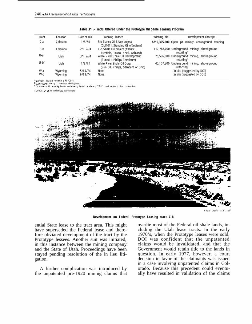
240 ● An Assessment of Oil Shale Technologies
Table 31 .–Tracts Offered Under the Prototype Oil Shale Leasing Program
Tract Location Date of sale Winning bidder Winning bid Development concept
C-a Colorado 1/8/74 Rio Blanco Oil Shale project $210,305,600 Open pit mining: aboveground retorting(Gulf 011, Standard Oil of Indiana)
C-b Colorado 2/1 2/74 C-b Shale Oil project (AtlanticRichfield, Tosco, Shell, Ashland)
U-ab
Utah 3/1 2/74 White River Shale Oil Development(Sun 011, Phillips Petroleum)
U-b b
Utah 4 / 9 / 7 4 White River Shale Oil Corp.(Sun Oil, Phillips, Standard of Ohio)
W-a Wyoming 5/14/74 NoneW-b Wyoming 6/11/74 None
117,788,000 Underground mining: abovegroundretorting a
75,596,800 Underground mining, abovegroundretorting c
45,107,200 Underground mining; abovegroundretorting
In situ (suggested by DOI)In situ (suggested by DO I)
alndlrec[ly healed retorfs (e g TOSCO It)bsubsequently umhed for common developmentccomblna[lon 01 Indtrec[ly heated and dwec!ly heated retorls (e g TOSCO II and paraho or 9as combustion)
SOURCE OftIce of Technology Assessment
Pho to c red i t OTA s ta f f
Development on Federal Prototype Leasing tract C-b
ential State lease to the tract area. This mighthave superseded the Federal lease and there-fore obviated development of the tract by thePrototype lessees. Another suit was initiated,in this instance between the mining companyand the State of Utah. Proceedings have beenstayed pending resolution of the in lieu liti-gation.
A further complication was introduced bythe unpatented pre-1920 mining claims that
overlie most of the Federal oil shale lands, in-cluding the Utah lease tracts. In the early1970’s, when the Prototype leases were sold,DOI was confident that the unpatentedclaims would be invalidated, and that theGovernment would retain title to the lands inquestion. In early 1977, however, a courtdecision in favor of the claimants was issuedin a case involving unpatented claims in Col-orado. Because this precedent could eventu-ally have resulted in validation of the claims
Ch 7–Resource Acquisition 241
overlying U-a and U-b, the lessees sued forand won a suspension in the lease terms, Thesuspension is still in effect, pending a Su-preme Court decision on the issue of unpat-ented claims. *
In summary, no permanent leasing pro-gram exists for the Federal oil shale lands,and under the present Prototype Program,four tracts have been leased, but two are in-active because of legal uncertainties. The
*On June 2, 1980, the U.S. Supreme Court decided in favor ofthe Colorado claimants (Andrus v. Shell oil, No. 78-1815).
other two, Colorado tracts C-a and C-b, arebeing developed for MIS processing, The les-sees of tract C-a are also negotiating for ademonstration of the Lurgi-Ruhrgas AGRtechnology. If both tracts proceed to commer-cialization, they could produce a total of133,000 bbl/d by 1987. With current plans,one mining technique, one in situ process, andone aboveground retort will be evaluated,Open pit mining will not be tested, nor willother in situ or AGR techniques. All of themining will be conducted in ground waterareas.
Land ExchangesAs discussed later, of the approximately
400,000 acres of privately owned land in Col-orado, about 170,000 acres contain at least10 ft of oil shale yielding 25 gal/ton. The totalpotential oil yield from these richer tracts isat least 80 billion bbl, which would support al-million-bbl/d industry for 240 years. How-ever, much of the privately held land is lo-cated on the fringes of the oil shale basins,and contains thinner, leaner deposits thandoes the adjacent Federal land. Furthermore,some of the private tracts are in small, non-contiguous parcels (mainly former home-steads and small mining claims) that couldnot be economically developed. Private oilshale development could be encouraged ifthese lands were exchanged for more eco-nomically attractive Federal tracts.
The exchanging of private mineral-bearingland for Federal land is allowed under sec-tion 206 of the Federal Land Policy and Man-agement Act of 1976 (FLPMA). Exchangesmay be consummated provided that they arein the public interest and that the propertiesinvolved are within 25 percent of equal value.The difference may be made up in cash.There are two options that would be particu-
larly suitable for the oil shale situations. Thefirst is the “blocking-up” of scattered or odd-ly shaped tracts by exchanging portions ofthem for adjacent Federal land, thereby cre-ating a tract geometry that could be devel-oped economically. Superior Oil Co. proposedsuch an exchange for its property in thenorthern Piceance basin. In this case, astringer of Superior land that extended intothe Federal holdings was to be exchanged fora parcel along the southern edge of the mainbody of the Superior property. EXXON Corp.has also proposed to exchange numeroussmall tracts along streambeds in the Piceancebasin for about 10,000 acres of Federal landnear the basin’s center.
The second option would involve exchang-ing a large block of private land on the fringeof the oil shale deposits for a substantiallysmaller block of Federal land in the richer,thicker areas. The Federal tract would haveto be much smaller, in general, because thedeposits under much of the Federal land areat least 1,000 ft thick; deposits on privatetracts along the basin’s fringe are seldommore than 250 ft thick.
The Adequacy of Private LandsMost of the privately owned lands in the through the filing of mining claims for oil
Piceance and Uinta basins were acquired shale and other minerals under the Mining

—
242 ● An Assessment of Oil Shale Technologies
Law of 1872. The provisions of the law re-quired that the mineral be “located” by theprospector; that is, he had to sample thedeposit and demonstrate, through assay, thatit contained the mineral of interest. In gener-al, the oil shales in Colorado and Utah aredeeply buried and therefore not visible fromthe surface. However, some deposits are visi-ble where streams have eroded through theoverburden. The early prospectors obtainedsamples from these outcrops, assayed them,filed claims for the outcrop and for the adja-cent land (which, it was inferred, also con-tained the mineral), and eventually obtainedpatents for the claimed land from the Govern-ment. Most of the original mining claims werequite small, but over the years the individualclaims have been purchased by major energycompanies and consolidated into much largerblocks that could be suitable for commercialdevelopment.
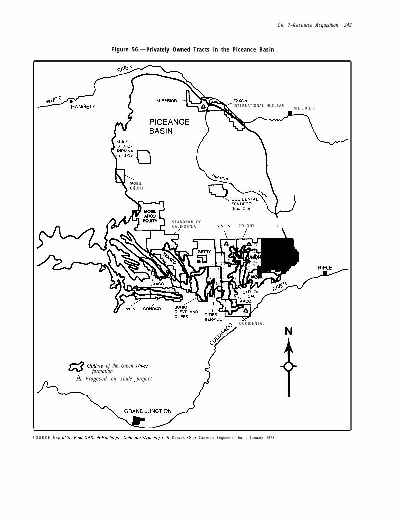
The locations of the larger privately ownedpatented or “fee” lands in the Piceance basinare shown in figure 56. * Because the oil shaledeposits were first detected along the Col-orado River, most of the fee lands are foundin the southern part of the basin. Because ofthe location requirements of the 1872 MiningLaw, they are generally found along stream-beds. Not shown in the figure are the numer-ous tracts of a few hundred acres that followthe streams in the central and northern partsof the basin. These were primarily earlyhomesteads and grazing lands, but many ofthem have been acquired by the energy com-panies. They are still used for farming andstock raising, which retains control of thewater rights.
The location of the private lands has sever-al implications for oil shale development be-cause, although they are extensive, they arenot so commercially attractive as the Federallands to the north. There are three reasonswhy they are not so attractive. First, they aremuch thinner and contain lower concentra-tions of kerogen than do the deposits on Fed-eral land. This is because the oil shale re-
*The term “fee’” is derived from the Middle English word~ie~: an inheritable or heritable estate in land.
sources were created on the bed of an an-cient lake by the deposition of silt and organicdebris carried into the lake by rivers andstreams. The lake had a bowl-shaped crosssection (hence, the term “basin”), and moresedimentation occurred near its depositionalcenters, which lie north of the geometriccenter of the basin—on Federal land. TheFederal deposits are therefore much thickerand, as a consequence, more amenable tolarge-scale development. The private lands,on the fringe of the basin corresponding tothe shoreline of the ancient lake, are muchthinner.
Second, because the level of water in thelake varied over time as the climate changed,the lakeshore advanced and receded. Whenthe water level was high, organic matter wasdeposited over a broader area and was con-verted to oil shale before it could be decom-posed by exposure to the air. When the waterlevel was low, more inorganic silt was de-posited, and any organic debris that was laiddown near the shoreline decomposed whenthe shoreline receded. As a consequence, thedeposits on the basin’s fringe are muchleaner on the average than the deposits to thenorth, and they occasionally are intermixedwith layers of rock containing essentially noorganic matter, This complicated stratigra-phy reduces the average oil yield from depos-its on private land, and makes them less suit-able for commercial development.
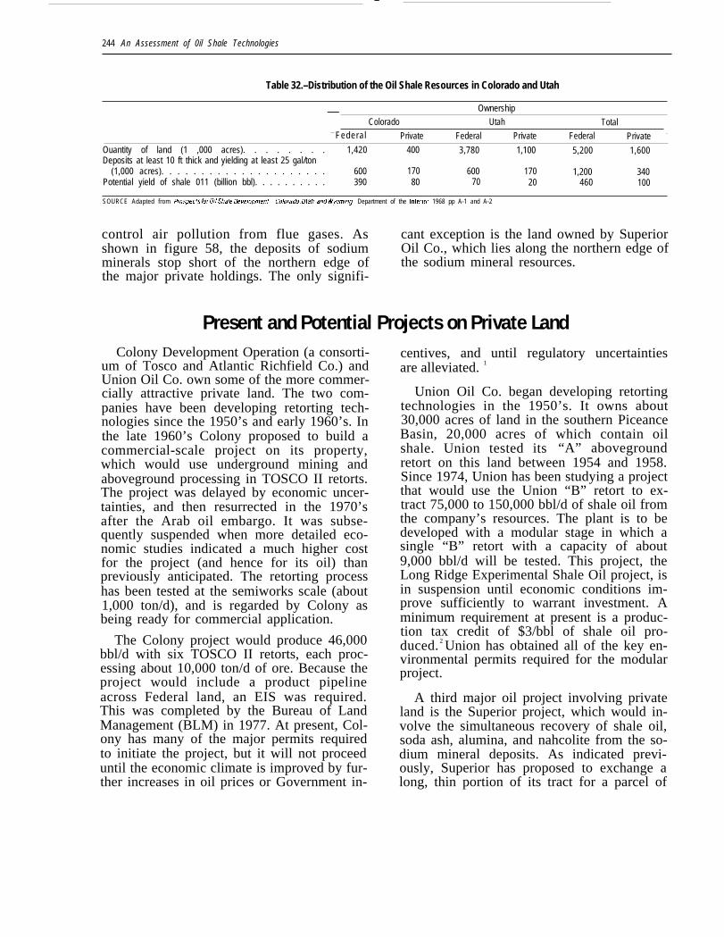
The net effect of these two conditions is in-dicated in table 32 and illustrated in figure57. As shown, the privately owned lands inColorado and Utah include about 340,000acres of deposits at least 10 ft thick thatwould yield at least 25 gal/ton of shale oil.The total potential yield from these depositsis about 100 billion bbl. In contrast, the Fed-eral lands have 1.2 million acres of equiva-lent deposits with a potential yield of 460 bil-lion bbl.
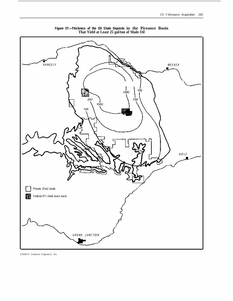
The third factor is that private lands con-tain essentially no commercially attractivedeposits of nahcolite and dawsonite—the so-dium minerals that are potential sources ofaluminum, glass, and the chemicals used to
Ch. 7–Resource Acquisition 243
Figure 56.— Privately Owned Tracts in the Piceance Basin
d INTERNATIONAL NUCLEARM E E K E R
Y7MOBILEQUITY
&ARCOEOUITY S T A N D A R D O F
C A L I F O R N I A UNlON C O L O N Y \
O C C I D E N T A L
(4
#@ N
Go
m outline of the Green /?iverformation
A Proposed oil shale project
S O U R C E M a p of the Ma/or 0// Shale Ho/dlrrgs-Colorado, Wyom/rtg Utah, Denver. Colo Cameron Engineers, Inc , January 1978
—
244 An Assessment of 0il Shale Technologies
Table 32.–Distribution of the Oil Shale Resources in Colorado and Utah
Ownership—Colorado Utah Total
— Federal Private Federal Private Federal Private -
Ouantity of land (1 ,000 acres). . . . . . . . 1,420 400 3,780 1,100 5,200 1,600Deposits at least 10 ft thick and yielding at least 25 gal/ton
(1,000 acres). . . . . . . . . . . . . . . . . . . . . 600 170 600 170 1,200 340Potential yield of shale 011 (billion bbl). . . . . . . . . . 390 80 70 20 460 100
SOURCE Adapted from Prospec(s for 0(/ .Sha/e Oeve/oprnen(-Colorado, Urah, and Wyormng, Department of the Intertor 1968 pp A-1 and A-2
control air pollution from flue gases. Asshown in figure 58, the deposits of sodiumminerals stop short of the northern edge ofthe major private holdings. The only signifi-
cant exception is the land owned by SuperiorOil Co., which lies along the northern edge ofthe sodium mineral resources.
Present and Potential Projects on Private LandColony Development Operation (a consorti-
um of Tosco and Atlantic Richfield Co.) andUnion Oil Co. own some of the more commer-cially attractive private land. The two com-panies have been developing retorting tech-nologies since the 1950’s and early 1960’s. Inthe late 1960’s Colony proposed to build acommercial-scale project on its property,which would use underground mining andaboveground processing in TOSCO II retorts.The project was delayed by economic uncer-tainties, and then resurrected in the 1970’safter the Arab oil embargo. It was subse-quently suspended when more detailed eco-nomic studies indicated a much higher costfor the project (and hence for its oil) thanpreviously anticipated. The retorting processhas been tested at the semiworks scale (about1,000 ton/d), and is regarded by Colony asbeing ready for commercial application.
The Colony project would produce 46,000bbl/d with six TOSCO II retorts, each proc-essing about 10,000 ton/d of ore. Because theproject would include a product pipelineacross Federal land, an EIS was required.This was completed by the Bureau of LandManagement (BLM) in 1977. At present, Col-ony has many of the major permits requiredto initiate the project, but it will not proceeduntil the economic climate is improved by fur-ther increases in oil prices or Government in-
centives, and until regulatory uncertaintiesare alleviated. 1
Union Oil Co. began developing retortingtechnologies in the 1950’s. It owns about30,000 acres of land in the southern PiceanceBasin, 20,000 acres of which contain oilshale. Union tested its “A” abovegroundretort on this land between 1954 and 1958.Since 1974, Union has been studying a projectthat would use the Union “B” retort to ex-tract 75,000 to 150,000 bbl/d of shale oil fromthe company’s resources. The plant is to bedeveloped with a modular stage in which asingle “B” retort with a capacity of about9,000 bbl/d will be tested. This project, theLong Ridge Experimental Shale Oil project, isin suspension until economic conditions im-prove sufficiently to warrant investment. Aminimum requirement at present is a produc-tion tax credit of $3/bbl of shale oil pro-duced. 2 Union has obtained all of the key en-vironmental permits required for the modularproject.
A third major oil project involving privateland is the Superior project, which would in-volve the simultaneous recovery of shale oil,soda ash, alumina, and nahcolite from the so-dium mineral deposits. As indicated previ-ously, Superior has proposed to exchange along, thin portion of its tract for a parcel of
Ch 7–Resource Acquisition 245
Figure 57.—Thickness of the Oil Shale Deposits in the Piceance BasinThat Yield at Least 25 gal/ton of Shale Oil
RANGELY
rMEEKER
ET
RIFLE■
Private (Fee) lands,
Federal 011 shale lease tracts
{
GRAND JUNCTION
%/
S O U R C E C a m e r o n E n g i n e e r s , I n c
.
246 ● An Assessment of Oil Shale Technologies
Figure 58.— Location of the Sodium Mineral Deposits in the Piceance Basin
Is MEEKER
-
El Private (Fee) lands
mFederal 011 shale lease tracts
--- Extent of the nahcohte deposi ts)
++ Extent of the dawsorute deposits5
S O U R C E B Welchman, Sa//fre Zone 0// Sha/e and the /rrtegrated In SIfu Process, Houston. Tex The Mult i Mineral Corp , May 1979 p 17

Ch. 7–Resource Acquisition ● 247
Federal land. BLM has issued a draft EIS forthe exchange, and recently completed a pre-liminary assessment of the value of the twotracts in question, as required by the equiv-alent-value provisions of FLPMA. Superior’sland was found to have a significantly lowervalue than the Federal land to be acquired.BLM has tentatively denied the application.Superior is preparing a response to the denialand BLM’s decision is open to review. If theexchange were approved, the project couldproduce about 11,500 bbl/d of shale oil, plusthe other byproducts, from a single Superioraboveground retort. The resources on thetract could support one additional retort ofthe same size.
Tosco is also developing the Sand Washproject on land leased from Utah. It is in itsearly stages and is proceeding at a relativelyslow pace. Under its leasing arrangements,Tosco is required to invest $8 million in tractdevelopment over an 8-year period. The sink-ing of a mine shaft has begun and will be com-pleted in about 1982. This will be followed byan experimental mining phase lasting from 2to 3 years.3 Thus, by 1985, Tosco could beready to build its retorting plant, which couldultimately have a capacity of 50,000 bbl/d. Ifa modular demonstration phase is included,the plant could be completed by 1995. If pre-commercial experiments are not conducted,as would be the case for Tosco’s Colony proj-ect, the plant could be completed as early as1990. However, this would require accelerat-ing the experimental, design, and construc-tion phases, which Tosco may not be willingto do in the absence of a highly favorableeconomic outlook. Tosco has not stated a posi-tion in regard to the types of encouragementthat would be required, but as a member ofthe Colony Development Operation, Tosco hassuggested a need for financial incentives andregulatory modifications,
Other private firms are also engaged inR&D activities on their tracts and on landleased from Utah. These projects are dis-cussed in detail in chapter 5. The Geokineticsproject, in which a true in situ (TIS) retorting
technique is being developed, is the only onefor which a commercial target—2,000 bbl/d—has been announced. Occidental Oil Shaleis conducting experiments on its land in theextreme southern Piceance basin. However,the tests at the Logan Wash site are support-ing the development of Federal lease tractC-b. The Logan Wash site has no commercialpotential. Equity Oil Co. is developing anotherTIS process on private land in Colorado, butno production target has been announced.
If all of the presently active or suspendedprojects on non-Federal land proceeded tocommercialization, the total productionwould be 280,000 to 350,000 bbl/d. However,this would require the following:
●
●
●
●
for Union: a production tax credit;for Colony (and probably for SandWash): incentives and alleviation of reg-ulatory uncertainties;for Superior: a land exchange and pos-sibly incentives; andfor Geokinetics: the continued supportby the Department of Energy (DOE) ofthe company’s experimental program.
There are other private tracts that have re-sources similar to those of Colony and Union.These include the tracts owned by Chevron(Standard Oil Co. of California), Getty Oil Co.,Cities Service Corp., and others. However, noprojects have been announced for any ofthese lands. In part, this reflects the techno-logical positions of the other landowners—they do not own advanced retorting technolo-gies. They may plan to license the processesof the other companies, once these have beendemonstrated, or to develop their own proc-esses once the economic viability of the oilshale industry appears assured. It appearsthat economic conditions would have to im-prove significantly in order to motivate thesepotential developers to complete their proj-ects before, say, 1990. A much stronger set ofincentives may be required than would beneeded by Union or Colony, who already haveboth good technological and resource posi-tions,
—
248 An Assessment of Oil Shale Technologies
Present and Potential Projects on Federal LandAs discussed in volume II and mentioned
earlier here, only two projects are activelybeing conducted as part of the PrototypeLeasing Program. Rio Blanco Oil Shale Co. isdeveloping tract C-a using MIS methods. Ademonstration of the Lurgi-Ruhrgas above--ground retort may be included. Tract C-b isbeing developed as the Cathedral BluffsShale Oil project. Occidental’s MIS technol-ogy is being used, and no plans have been an-nounced for a concurrent demonstration ofAGR technologies. The White River project ontracts U-a and U-b, which were unified forjoint development, is presently in suspensionpending resolution of ownership.
Paraho Development is also engaged in aproject involving Federal land at the DOEresearch facility in Anvil Points, Colo. AnvilPoints was the site of Paraho’s retort develop-ment program. Paraho is attempting to ex-tend the terms of its lease to include a mod-ular demonstration program and to obtainfunding for the project. The outlook is uncer-tain, because an EIS is required and none hasyet been issued, despite four attempts byDOE. Paraho’s management is also pursuinga production tax credit to improve theeconomic outlook for shale oil.
As mentioned earlier, EXXON Corp. hasalso proposed to exchange its scattered hold-ings for a single tract of Federal land in Col-orado. The future of this proposal is uncer-tain. If Superior’s land-exchange experienceis regarded as typical, preparation and re-view of the EXXON proposal could take aslong as 8 years. Four years is more likely.
DOE and the Department of Defense arepreparing a management plan for developingNaval Oil Shale Reserve No. 1 (NOSR 1),which is contiguous to the Anvil Points site.This project is in the early stages, and thepotential production cannot be accurately es-timated. However, if all of the preliminary ex-ploration, design work, and permitting can becompleted by 1986, and if plant constructionwere expedited, DOE believes that NOSR 1
could be producing at least 100,000 bbl/d by1990.
Multi Mineral Corp. has proposed to use amine shaft on Federal land in the northern Pi-ceance basin to develop an MIS process to re-cover shale oil, alumina, and nahcolite fromdeeply buried deposits. The shaft was drilledin 1978 by the U.S. Bureau of Mines to devel-op mining techniques for sodium mineralsand oil shale in the saline zone. * The proposalinvolves a three-phase project that could leadto a 50,000-bbl/d operation.
If all of the presently active and proposedprojects involving Federal land were com-pleted, the total production could exceed300,000 bbl/d, plus any additional productionfrom NOSR 1. However, only 57,000 bbl/d ofthis production is assured, because onlyCathedral Bluffs is committed to commercial-ization. Rio Blanco is committed only to test-ing its development techniques at the precom-mercial level—approximately 2,000 bbl/d.The decision to proceed to commercial levelsof production will depend on the technicalfeasibility of the MIS and Lurgi-Ruhrgasmethods and on the existence of a favorableeconomic and regulatory climate. Therefore,achieving 300,000 bbl/d from these opera-tions is likely to require the following:
●
●
●
●
for Cathedral Bluffs: continued techni-cal progress and continuation of a favor-able economic outlook;for Rio Blanco: technical progress andfavorable project economics, perhaps in-cluding Federal financial incentives;for Paraho: extension of the terms of theAnvil Points lease and provision of a pro-duction tax credit;for White River: favorable resolution ofthe ownership dispute and possibly Fed-eral incentives (Standard Oil Co. of Ohio(SOHIO) is a participant in the White
*The Multi Mineral technology is discussed in ch. 5. The ge-ology and stratigraphy of the oil shale basins are discussed inch. 4.

Ch. 7–Resource Acquisition 249
River project. SOHIO is also involved inthe Paraho operation.); and
● for EXXON: approval of the proposedland exchange.
The potential production from tract C-acould be expanded by 75,000 bbl/d if the les-sees returned to their original open pit miningplan. However, to allow maximum recoveryof the oil shale resource, lands outside of thetract boundaries would have to be used forwaste disposal and the siting of the process-ing facilities. Such off tract land use is pres-
ently banned by Federal statutes, includingthe acreage limitation of the Mineral LeasingAct and the provisions of FLPMA, whichstate:
Is More Federal Land Needed?
Nothing in this Act, or in any amendmentmade by this Act, shall be constructed aspermitting any person to place, or allow to beplaced, spent shale oil, overburden, or by-products from the recovery of other mineralwith oil shale, on any Federal land other thanFederal land which has been leased for therecovery of oil shale . . .
As discussed in chapter 6, shale oil ap-pears to be economically competitive, basedon the present and projected prices of foreigncrude oil and some premium-quality domesticcrudes. However, technical, economic, andregulatory risks are inhibiting potential de-velopers from making large capital invest-ment commitments to shale development.These uncertainties are aggravated by someof the characteristics of the private landswhich, in general, are not so favorable asthose of adjacent Federal lands. Further-more, the privately owned lands contain es-sentially no commercially attractive depositsof sodium minerals. Assuming that these min-erals could be extracted economically, theycould be sold as byproducts to enhance theeconomic feasibility of a project. Whethermore Federal land must be provided depends
how much production is desired;how rapidly the industry is to be cre-ated;whether production of sodium minerals,or testing of the “multimineral” technol-ogies used to extract them, is desired;how much technical, economic, and envi-ronmental information is desired to as-sist policymaking and the setting of envi-ronmental regulations; andwhether financial incentives are pro-vided that will encourage the continua-tion of present projects on the Federal
lease tracts and also initiate projects onprivate lands.
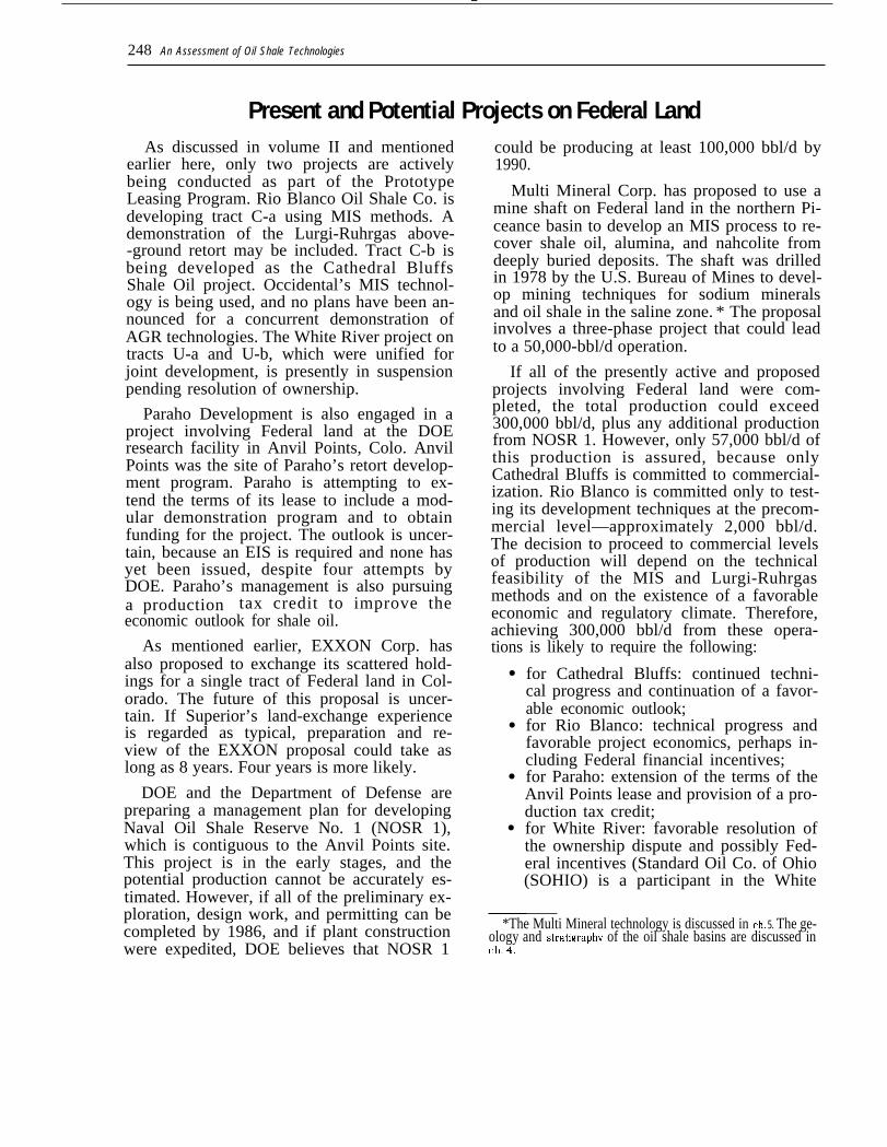
The need for additional Federal land willdepend strongly on the size of the industryand the pace of its creation. It will also be af-fected by the other Federal oil shale policies,especially those involving financial incen-tives. This is shown in table 33, which indi-cates how the industry’s capacity in 1990might be affected by different Federal ac-tions. As shown for case 1, about 60,000 bbl/dcould be achieved with no additional actions,assuming that the Cathedral Bluffs project iscompleted and that Geokinetics reaches itsproduction target. If economic conditions en-courage Rio Blanco to continue and SandWash to accelerate, production could reach185,000 bbl/d by 1990. If incentives areadded (case 2) that assure completion ofthese two projects, that encourage the Colonyand Union projects to resume, and that alsoinitiate a new project on private land, produc-tion would reach 360,000 bbl/d. This could beexpanded in case 3 to nearly 400,000 bbl/d ifthe Superior land exchange is consummated(or a lease issued for the desired parcel) andtest sites are provided for the Paraho andMulti Mineral processes. All three of theseprojects would involve providing access to ad-ditional Federal land.
If the ownership conflicts surrounding theUtah lease tracts are resolved in a manner
—
250 ● An Assessment of Oil Shale Technologies
Table 33.–Estimated Shale Oil Production by 1990 in Response to Various Federal Actions
CaseFederal action 1 2 3 4 5 6 7 8None. . . . . . . . . . . . . . . . . . . . . . . . . . . . . . xIncentives for first-generation developers . . . . x x x x xTest sites for modular retortsb . . . . . . . . . . . . x x x x x xResolution of ownership issues on Utah tractsc. x x x x xOfftract land used . . . . . . . . . . . . . . . . . . . . x x x xProposed land exchanges. . . . . . . . . . . . . . x x xIncentives for second-generation developers
(or improved economics) . . . . . . . . . . . . . x xNaval Oil Shale Reserves or expanded
Prototype Program or permanent leasing. . . . xProduction, bbl/d . . . . . . . . . . . . . . . . . . . 6 0 , 0 0 0 - 3 6 0 , 0 0 0 3 9 0 , 0 0 0 4 9 0 , 0 0 0 5 6 0 , 0 0 0 6 2 0 , 0 0 0 8 5 0 , 0 0 0 1,000,000
185,000 f
aASSumeS the entry of one as-yet unannounced developerblncludo~ the proposed superior 011 land exchange and a Ieasmg of Anwl POIIIIS by parafio DeVe@rrrerrlCReSurnptlOrl of the tract U-a/(J-b project may also depend on the availablhty of Incentives and On other lmProvemenfs In Protect economicsaFor waste disposal from the o~n plt mme that was Ongmally proposed for traCt C-aelncludes the proposed Supertor 011 and EXXON land mcharwsfonly 59,000 bbllfj IS llrmly Cwnrnmed
SOURCE Off Ice of Technology Assessment
favoring the lessees, and if appropriate in-centives are provided, the White River proj-ect could resume. This would add 100,000bbl/d to the industry’s capacity. Productioncould reach 560,000 bbl/d if Rio Blanco weregiven permission to use offtract lands andreturned to its original open pit mining plan,as assumed for case 5. If the EXXON land ex-change were completed (case 6), productionwould be increased by 60,000 bbl/d. Asshown for case 7, production might be in-creased to 850,000 bbl/d by providing sub-sidies that were sufficiently attractive to en-courage the participation of the “second gen-eration” of developers—those who are not astechnically advanced as Colony and Union, orwho lack resources of equivalent quality. Thetotal additional capacity indicated corre-sponds to about five additional major projectson private land. The Government could alsobecome more directly involved in oil shale
development by leasing additional tracts orby developing NOSR 1 (case 8). The industry’scapacity in 1990 could then reach 1 millionbbl/d.
In summary, reaching 200,000 bbl/d by1990 may not require the release of substan-tial tracts of Federal land, if the presently ac-tive projects are technically successful and ifthe economic outlook remains favorable. Only60,000 bbl/d of this capacity is assured.About 400,000 bbl/d might be achieved if ef-fective incentives were provided and testsites allocated for retorting demonstrations.Achieving 1 million bbl/d by 1990 might re-quire subsidies, land exchanges, permissionto use offtract land for waste disposal andfacility siting, and the leasing of additionaltracts or the development of the Naval OilShale Reserves.
● To amend the Mineral Leasing Act of proving economic feasibility. It might also1920.—The Act could be amended to in- allow the inclusion of a suitable wastecrease the acreage limitations, or to set the disposal site within a tract’s boundariessize of the tract according to the recover- while still providing adequate oil shaleable resources it contained. This might al- resources for sustained, large-scale opera-low more economies of scale, thereby im- tions, thus avoiding the need for separate
Ch 7–Resource Acquisition . 251
●
●
●
offtract disposal authorization. The num-ber of leases per person or firm could alsobe increased. This might provide additionalencouragement to firms that do not own oilshale lands because it would allow them toacquire experience on one lease tract andthen apply it to another while the first wasstill operating. A disadvantage would bethat the number of firms participating inthe leasing program could be reduced if afew firms acquired all of the leases. Oneoption would be to increase the number toone lease per State. This might encouragea firm to develop a process in the richer de-posits in Colorado and then apply it to thepoorer quality resources in Utah or Wyo-ming.
To amend FLPMA.—FLPMA could beamended to allow including conditions(such as environmental stipulations anddiligence requirements) in any oil shaleland exchange agreement. This would im-prove the Government’s control over theexchanged parcel. It might also discourageprivate participation.
To allow offsite land use for leasetracts. —Legislation could be provided toallow a lessee to use land outside of theboundaries of a lease tract for facility sit-ing and waste disposal. This might permitlarger, more economical operations (in-cluding perhaps an open pit mine) andwould maximize resource recovery on thetract. However, subsequent developmentof the offtract areas would be inhibited.(DOI estimated that Rio Blanco’s offtractdisposal plan would reduce resource re-covery from the disposal area by about 5percent.)
To lease additional tracts under the Proto-type Program. —There is no statutory lim-itation on the number of tracts that couldbe leased under the Prototype Program.However, DOI originally committed to leas-ing no more than six. Because two of theoriginal tracts were not leased, offeringtwo new ones might be justified, providedthat the technologies to be tested were dif-ferent from the processes being developed
on the existing tracts. Leasing more thantwo more tracts, or leasing for the purposeof expanding near-term shale oil produc-tion, would encounter political oppositionby the critics of rapid oil shale develop-ment. Leasing could begin sooner than un-der a new leasing program, if some of thepotential lease tracts previously nominatedwere offered. A supplemental EIS would berequired. Construction on the tracts couldprobably not begin until about 1985 andproduction no sooner than 1990. Consider-ation might be given to leasing a tract formultimineral operations, a process that isnot being evaluated in any project at pres-ent. (One of the primary goals of the Proto-type Program is to obtain informationabout a variety of technologies. )
To initiate a new, permanent leasing pro-gram.—An advantage would be that moreproduction could be achieved than is possi-ble under the present Prototype Program.A full EIS and a new set of leasing regula-tions would be needed. Without the infor-mation to be acquired by completing thepresent Prototype Program projects, itmight be difficult to prepare an accurateenvironmental assessment and to structurecomprehensive leasing regulations. Pro-duction could probably not begin until after1990. Abandonment of the Prototype Pro-gram would be implied, which might engen-der political opposition.
To expedite land exchanges.—The reviewand approval procedures could be expe-dited by, for example, setting up a taskforce within DOI specifically for oil shaleproposals.
Government development.—The Govern-ment could develop the Naval Oil Shale Re-serves. Unless this were done by leasing toprivate developers, it would involve compe-tition with private industry, and would en-counter political opposition. It would alsobe very costly because the public wouldhave to pay the full cost of the facilities,and it might discourage independent ex-periments by private firms. Informationuseful in developing policies and regula-
252 ● An Assessment of Oi/ Shale Technologies
tions for the industry would be obtained.However, because the Government’s expe-rience with financing and operating a facil-ity would be substantially different fromthat of private developers, the informationmight not be useful in evaluating private in-
Chapter 7IHO F. Coffer and A. Christianson, eds., EPA Pro-
gram Conference Report: Oil Shale, EPA-600/0-79-025, July 1979, p. 90
vestment decisions. Some of the informa-tion is being acquired in the present Proto-type Program. It could also be obtained inadditional leasing programs or through li-censing arrangements with the owners ofthe technologies.
References‘Ibid., at p. 27.31bid.