CHAPTER 6 ADDITIVE AND COLLECTIVE...
122
Guam and CNMI Military Relocation (2012 Roadmap Adjustments) SEIS Draft April 2014 6-1 CHAPTER 6 ADDITIVE AND COLLECTIVE IMPACTS This chapter presents two sections that evaluate the following additive and collective impacts of the Marine Corps relocation to Guam: Section 6.1 addresses additive impacts of the SEIS proposed action that would result specifically from the combination of a cantonment/family housing alternative with an LFTRC alternative. For example, traffic impacts associated with project- related vehicle trips between cantonment/ family housing facilities and range facilities would depend on which pair of respective site alternatives is considered. Similarly, the routing of proposed new IT/COMM infrastructure to connect the ranges and the cantonment area (as described in Section 2.6 of this SEIS) would vary depending on the specific combination of cantonment and LFTRC alternatives. These project components were not addressed in Chapter 4 (cantonment impacts) or Chapter 5 (LFTRC impacts) because they would be a function of the combination of alternatives rather than any individual site alternative. Section 6.1 focuses only on those resources for which these types of additive impacts would be applicable. Section 6.2 addresses the “collective” impacts attributable to the overall Marine Corps relocation to Guam, which includes not only the re-analyzed actions in the 2012 Roadmap Adjustments (assessed in Chapters 4 and 5 and 6.1 of this SEIS), but also the Marine Corps relocation projects that were fully considered and analyzed in the 2010 Final EIS and remain final from the 2010 ROD, and thus do not require further analysis in this SEIS (hereinafter “2010 ROD-Related Actions”). Unlike the preceding Chapters 4 and 5, this chapter does not contain a section pertaining to the No-Action Alternative. The No-Action Alternative for this SEIS (see Sections 2.1 and 4.5) already corresponds to the complete set of Marine Corps relocation projects that were selected for implementation in the 2010 ROD. Therefore, the collective impacts of implementing the No-Action Alternative were already analyzed in the 2010 Final EIS and summarized in the 2010 ROD.
-
Upload
trinhnguyet -
Category
Documents
-
view
215 -
download
0
Transcript of CHAPTER 6 ADDITIVE AND COLLECTIVE...
Guam and CNMI Military Relocation
(2012 Roadmap Adjustments) SEIS Draft April 2014
6-1
CHAPTER 6
ADDITIVE AND COLLECTIVE IMPACTS
This chapter presents two sections that evaluate the following additive and collective impacts of the
Marine Corps relocation to Guam:
Section 6.1 addresses additive impacts of
the SEIS proposed action that would
result specifically from the combination of
a cantonment/family housing alternative
with an LFTRC alternative. For example,
traffic impacts associated with project-
related vehicle trips between cantonment/
family housing facilities and range
facilities would depend on which pair of
respective site alternatives is considered.
Similarly, the routing of proposed new
IT/COMM infrastructure to connect the
ranges and the cantonment area (as
described in Section 2.6 of this SEIS)
would vary depending on the specific
combination of cantonment and LFTRC
alternatives. These project components
were not addressed in Chapter 4
(cantonment impacts) or Chapter 5
(LFTRC impacts) because they would be
a function of the combination of
alternatives rather than any individual site
alternative. Section 6.1 focuses only on those resources for which these types of additive impacts
would be applicable.
Section 6.2 addresses the “collective” impacts attributable to the overall Marine Corps relocation
to Guam, which includes not only the re-analyzed actions in the 2012 Roadmap Adjustments
(assessed in Chapters 4 and 5 and 6.1 of this SEIS), but also the Marine Corps relocation projects
that were fully considered and analyzed in the 2010 Final EIS and remain final from the 2010
ROD, and thus do not require further analysis in this SEIS (hereinafter “2010 ROD-Related
Actions”).
Unlike the preceding Chapters 4 and 5, this chapter does not contain a section pertaining to the No-Action
Alternative. The No-Action Alternative for this SEIS (see Sections 2.1 and 4.5) already corresponds to the
complete set of Marine Corps relocation projects that were selected for implementation in the 2010 ROD.
Therefore, the collective impacts of implementing the No-Action Alternative were already analyzed in the
2010 Final EIS and summarized in the 2010 ROD.

Guam and CNMI Military Relocation
(2012 Roadmap Adjustments) SEIS Draft April 2014
6-2
6.1 ADDITIVE IMPACTS FROM COMBINED ALTERNATIVES
As explained above, this section focuses on the additive impacts of the SEIS proposed action that were
not previously addressed in Chapters 4 and 5 because they are a product of the combination of
cantonment/family housing and LFTRC site alternatives. These additive impacts may result from
construction of the connecting IT/COMM infrastructure described in Section 2.6 of this SEIS, from an
increase in traffic on roads connecting a cantonment/family housing area with an LFTRC, or from other
characteristics of an alternative site combination.
The following nine resource areas would not be subject to additive impacts from IT/COMM installation,
an increase in traffic, or any other factors associated solely with the combination of specific cantonment/
family housing and LFTRC alternatives: airspace, recreation, marine biological resources, visual
resources, marine transportation, utilities, land and submerged land use, socioeconomics and general
services, and environmental justice. These resources are therefore not discussed further in this section.
Section 6.1.1 addresses short-term and less than significant additive impacts that would occur during
construction of the IT/COMM links but would not vary appreciably with specific site combinations. Such
impacts apply to geological and soil resources, water resources, noise, ground transportation, and
hazardous materials and waste. Because the additive impacts described in Section 6.1.1 would be less
than significant and would not vary by site combination, they are addressed qualitatively by resource area.
Section 6.1.2 addresses additive impacts (from construction and/or operations) that would vary
appreciably for different site combinations (and may include some IT/COMM construction impacts).
Such impacts apply to the following resource areas: air quality, terrestrial biological resources, cultural
resources, and public health and safety. In addition, ground transportation is discussed in this section
because traffic impacts would vary depending on the location of the cantonment/family housing and
LFTRC alternatives. Section 6.1.2 describes these impacts for the various site combinations, which are
grouped in some cases based on geographic proximity, due to the large number of possible site
combinations.
6.1.1 Additive IT/COMM Construction Impacts That Do Not Vary by Alternative Combination
Geological and Soil Resources 6.1.1.1
The installation of IT/COMM links between any pair of cantonment/family housing and LFTRC site
alternatives would result in direct, short-term impacts to geological and soil resources along the
IT/COMM routes. Earthmoving activities would occur mostly within previously-disturbed roadways (the
term “roadways” includes road surface plus adjacent shoulders) that do not contain important soil
resources. Standard BMPs would be implemented to avoid and minimize typical construction-related
impacts (e.g., erosion) and impacts would therefore be less than significant.
Water Resources 6.1.1.2
Construction associated with the IT/COMM lines would result in the potential for short-term increases in
stormwater runoff and erosion. The characteristics of the potentially disturbed area would vary somewhat
depending on the IT/COMM route (see Table 2.6-1 and Figure 2.6-1 in Chapter 2 for details of the
specific routes for each cantonment/LFTRC combination) and, as shown in Table 6.1.1-1, some routes are
closer to surface waters and wetlands than others. However, through compliance with the Construction
General Permit and Program SWPPP, and implementation of site-specific SWPPPs, and associated
erosion control, runoff reduction, and sediment removal BMPs (see Table 4.1.2-2 in Chapter 4 of this
SEIS), these effects would be minimized and off-site transport of stormwater runoff would be unlikely,

Guam and CNMI Military Relocation
(2012 Roadmap Adjustments) SEIS Draft April 2014
6-3
except during extreme weather events (i.e., typhoons). In addition, roadway-specific BMPs, as identified
in the most recent CNMI and Guam Stormwater Management Manual, would be implemented, as
applicable. Specifically, the site-specific SWPPPs would identify appropriate BMPs for each route that
would contain runoff and sediment on-site (by reducing the flow rate of runoff), thereby minimizing the
suspension of sediments and promoting infiltration of runoff. These stormwater runoff protection
measures would also serve to both protect surface water, groundwater, and wetlands from indirect
impacts, as well as to prevent impacts to nearshore waters.
Table 6.1.1-1. Surface Waters in the Vicinity of IT/COMM Links between Alternatives
Cantonment/Family
Housing Alternatives
LFTRC Alternatives
Route 15
Alternative 1
NAVMAG
(East/West)
Alternative 2
NAVMAG
(North/South)
Alternative 3
NAVMAG
(L-Shaped)
Alternative 4
NWF
Alternative 5
Number of Surface Waters (Other waters of the U.S. / Wetlands)*
Alternative A: Finegayan
and Alternative B:
Finegayan/South Finegayan
6 / 1 21 / 1 18 / 3 21 / 1 6 / 1
Alternative C: AAFB 6 / 1 21 / 1 18 / 3 21 / 1 6 / 1
Alternative D: Barrigada 6 / 1 20 / 1 17 / 3 20 / 1 6 / 1 Notes: * The number of wetlands and other waters of the U.S. were tabulated based on the occurrence of a distinct surface water
feature within 100 feet (30 m) of the IT/COMM footprint. Any surface water feature occurring outside of this distance
would be unlikely to be affected with implementation of construction BMPs.
Because the IT/COMM lines would primarily be located in existing roadways, no direct impacts to
wetlands or other waters of the U.S. are anticipated. The potential exposure to direct or indirect impacts at
any one location or resource would be short-term, given that construction would not occur simultaneously
along the entire IT/COMM route at any one time, and construction at any one location would be of a
relatively short duration. Based on these considerations, and given that construction would comply with
Construction General Permit requirements and implementation of SWPPPs and BMPs, the proposed
construction activities associated with IT/COMM lines would result in less than significant impacts to
water resources on any of the routes.
Noise 6.1.1.3
Noise impacts from installation of the IT/COMM lines would only occur in close proximity to the
construction activities and would primarily occur along existing roadways that have higher levels of
ambient noise from road traffic and other sources. Installation of the IT/COMM lines would be very
short-term, lasting only a few days near any given noise receptor before moving along the road easement.
Therefore, the impacts would be less than significant.
Ground Transportation 6.1.1.4
Construction of the IT/COMM links between any given combination of cantonment/family housing and
LFTRC alternatives would occur primarily along existing roadways, and would potentially include
clearing and grubbing, demolition of existing road pavement, excavation, filling, paving, and landscaping.
During the construction period in the immediate vicinity of any given construction area along an
IT/COMM route, short-term, intermittent impacts to traffic flow would include additional traffic
congestion, slower speeds in construction zones, and short detours that may be caused by truck and
equipment movements, construction worker vehicles, the delivery of construction materials and
equipment, and removal of construction debris. Potential direct and indirect impacts to ground
transportation resources from IT/COMM construction would be minimized with implementation of
appropriate work zone traffic management strategies and BMPs. Therefore, the installation of IT/COMM
Guam and CNMI Military Relocation
(2012 Roadmap Adjustments) SEIS Draft April 2014
6-4
infrastructure along any route would have less than significant direct and indirect short-term impacts to
roadways.
Hazardous Materials and Wastes 6.1.1.5
Hazardous substances are not anticipated to be widely used or generated for the installation of IT/COMM
lines at or between the cantonment, housing, or LFTRC sites. These materials would continue to be
managed as described in this SEIS and the 2010 Final EIS (Volume 2, Chapter 17: Table 17.2-3:
Summary of BMPs and SOPs, pages 17-42 to 17-43 and Volume 7, Chapter 2: Overview of Best
Management Practices and Mitigation Measures, Table 2.1-1, Summary of Key Best Management
Practices [Guam and Tinian], pages 2-4 to 2-23). With regard to previously contaminated sites,
installation of IT/COMM links would avoid contaminated sites to the maximum extent practicable. If
IT/COMM routes were unable to avoid areas where contamination and/or MEC has been identified, a
site-specific health and safety plan would be used to ensure that the risk of human exposure to
contaminated media is minimized through engineering and administrative controls and appropriate
personal protective equipment. In addition, Phase I and II Environmental Site Assessments would be
conducted in areas requiring new or additional IT/COMM right-of-way easements prior to construction
activities to ensure that project plans consider and address contaminated sites. If installation of IT/COMM
links require the demolition or renovation of structures constructed prior to 1978, these structures would
be inspected for PCBs, ACM, and LBP. If these materials were identified, licensed contractors would
properly remove and dispose of them in accordance with relevant local and federal regulations.
Installation of IT/COMM lines would result in less than significant impacts with regard to hazardous
materials and wastes.
6.1.2 Additive Impacts That Vary by Site Combination
Finegayan Cantonment/Family Housing Alternative A or B with Route 15 LFTRC Alternative 6.1.2.1
1
Air Quality
Finegayan Cantonment/Family Housing Alternative A with Route 15 LFTRC Alternative 1
As discussed in Section 3.3.3.1, this SEIS updated or amended the 2010 Final EIS for the following two
analysis elements:
Hot-spot concentration impacts for mobile source CO, PM, and MSATs under both construction
and operation phases.
Construction phase, island-wide annual emissions for criteria pollutants and CO2.
As discussed in Sections 3.3.3.1, 4.1.3, and 5.1.3, the on-site and off-site hot-spot analyses were
conducted based on the forecasts of location-specific traffic and construction activities under the preferred
alternative and the alternative with the likely maximum potential adverse effect. The analysis results
indicate that the predicted hot-spot impacts are well below the applicable standards for respective
pollutants. Therefore, it can be concluded that the findings shown in Sections 4.1.3 and 5.1.3 would
remain the same for each of the combined alternatives and would represent minimal localized hot-spot
impacts.
Construction phase, island-wide annual emissions for criteria pollutants and CO2 would have combined
effects from any pair of cantonment/family housing and LFTRC alternatives. The additional combined
island-wide construction emissions are considered in this chapter by combining annual emissions
forecasted in Chapters 4 and 5 (see Tables 4.1.3-1 and 5.1.3-1) to determine the potential emissions

Guam and CNMI Military Relocation
(2012 Roadmap Adjustments) SEIS Draft April 2014
6-5
impact significance using the 250 tpy threshold. Because all of the alternative LFTRC sites are located
outside the two SO2 nonattainment areas, there would be no additive impacts from any of the combined
alternatives with respect to the CAA general conformity rule applicability requirement. Therefore, general
conformity analysis would not be needed for any of the combined alternatives. Although there would be
many IT/COMM line installation options along various routes, the longest route was used to
conservatively estimate the emissions associated with IT/COMM line construction activities between
2018 and 2020. These scenarios with the maximum potential adverse effect of IT/COMM construction
emissions were then considered for each combined alternative discussed in this Chapter.
The combined construction emissions are summarized in Table 6.1.2-1. Air quality impacts would be less
than significant because construction emissions from the combined alternative would be below the
significance criterion of 250 tpy for criteria pollutants. As described in Section 3.3, in contrast to criteria
pollutants, there are no NAAQS significance thresholds for greenhouse gas emissions, including CO2.
Nevertheless, the predicted greenhouse gas emissions levels for this combined alternative are still
presented in Table 6.1.2-1.
Table 6.1.2-1. Finegayan Cantonment/Family Housing (Alternative A) with Route 15 LFTRC
(Alternative 1) Annual Construction Emissions (2016-2022)
Construction
Year
Pollutant (tpy)
SO2 CO PM10 PM2.5 NOx VOCs CO2
2016 neg neg neg neg neg neg neg
2017 0.1 4.0 0.4 0.4 5.6 0.7 801.5
2018 0.5 32.8 2.1 1.9 24.7 4.4 5036.5
2019 0.7 45.7 2.7 2.4 32.2 5.4 7133.1
2020 0.2 18.7 1.1 1.0 11.3 2.6 2507.0
2021 0.8 45.9 2.8 2.5 35.5 4.7 7855.2
2022 0.2 13.6 0.8 0.7 10.5 1.4 2324.4
Significance Threshold 250 250 250 250 250 250 NA Legend: neg = negligible; NA = not applicable.
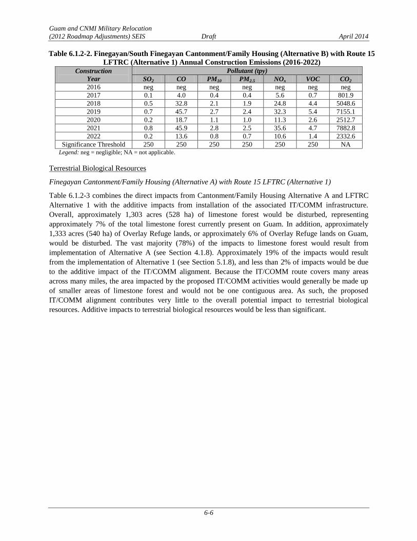
Finegayan/South Finegayan Cantonment/Family Housing Alternative B with Route 15 LFTRC
Alternative 1
The combined air quality impacts for this site combination would be similar to those described above for
the combination with Alternative A. Because partial construction activities under this combined
alternative would occur within the Tanguisson SO2 nonattainment area, the CAA general conformity rule
would apply to these activities. Based on the predicted annual island-wide combined SO2 emissions, as
shown in Table 6.1.2-2, the annual construction SO2 emissions within the Tanguisson nonattainment areas
would be well below the 100 tpy de minimis threshold. Therefore, the formal CAA general conformity
rule determination is not required. The combined construction island-wide emissions impacts,
summarized in Table 6.1.2-2, would be below the significance criterion of 250 tpy for criteria pollutants,
and would therefore be less than significant for this site combination.
Guam and CNMI Military Relocation
(2012 Roadmap Adjustments) SEIS Draft April 2014
6-6
Table 6.1.2-2. Finegayan/South Finegayan Cantonment/Family Housing (Alternative B) with Route 15
LFTRC (Alternative 1) Annual Construction Emissions (2016-2022)
Construction
Year
Pollutant (tpy)
SO2 CO PM10 PM2.5 NOx VOC CO2
2016 neg neg neg neg neg neg neg
2017 0.1 4.0 0.4 0.4 5.6 0.7 801.9
2018 0.5 32.8 2.1 1.9 24.8 4.4 5048.6
2019 0.7 45.7 2.7 2.4 32.3 5.4 7155.1
2020 0.2 18.7 1.1 1.0 11.3 2.6 2512.7
2021 0.8 45.9 2.8 2.5 35.6 4.7 7882.8
2022 0.2 13.6 0.8 0.7 10.6 1.4 2332.6
Significance Threshold 250 250 250 250 250 250 NA Legend: neg = negligible; NA = not applicable.
Terrestrial Biological Resources
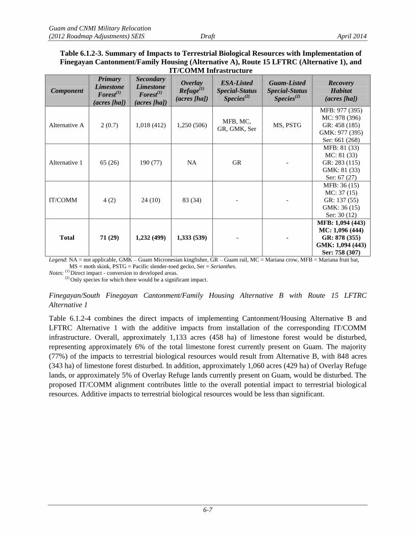
Finegayan Cantonment/Family Housing (Alternative A) with Route 15 LFTRC (Alternative 1)
Table 6.1.2-3 combines the direct impacts from Cantonment/Family Housing Alternative A and LFTRC
Alternative 1 with the additive impacts from installation of the associated IT/COMM infrastructure.
Overall, approximately 1,303 acres (528 ha) of limestone forest would be disturbed, representing
approximately 7% of the total limestone forest currently present on Guam. In addition, approximately
1,333 acres (540 ha) of Overlay Refuge lands, or approximately 6% of Overlay Refuge lands on Guam,
would be disturbed. The vast majority (78%) of the impacts to limestone forest would result from
implementation of Alternative A (see Section 4.1.8). Approximately 19% of the impacts would result
from the implementation of Alternative 1 (see Section 5.1.8), and less than 2% of impacts would be due
to the additive impact of the IT/COMM alignment. Because the IT/COMM route covers many areas
across many miles, the area impacted by the proposed IT/COMM activities would generally be made up
of smaller areas of limestone forest and would not be one contiguous area. As such, the proposed
IT/COMM alignment contributes very little to the overall potential impact to terrestrial biological
resources. Additive impacts to terrestrial biological resources would be less than significant.
Guam and CNMI Military Relocation
(2012 Roadmap Adjustments) SEIS Draft April 2014
6-7
Table 6.1.2-3. Summary of Impacts to Terrestrial Biological Resources with Implementation of
Finegayan Cantonment/Family Housing (Alternative A), Route 15 LFTRC (Alternative 1), and
IT/COMM Infrastructure
Component
Primary
Limestone
Forest(1)
(acres [ha])
Secondary
Limestone
Forest(1)
(acres [ha])
Overlay
Refuge(1)
(acres [ha])
ESA-Listed
Special-Status
Species(2)
Guam-Listed
Special-Status
Species(2)
Recovery
Habitat
(acres [ha])
Alternative A 2 (0.7) 1,018 (412) 1,250 (506) MFB, MC,
GR, GMK, Ser MS, PSTG
MFB: 977 (395)
MC: 978 (396)
GR: 458 (185)
GMK: 977 (395)
Ser: 661 (268)
Alternative 1 65 (26) 190 (77) NA GR -
MFB: 81 (33)
MC: 81 (33)
GR: 283 (115)
GMK: 81 (33)
Ser: 67 (27)
IT/COMM 4 (2) 24 (10) 83 (34) - -
MFB: 36 (15)
MC: 37 (15)
GR: 137 (55)
GMK: 36 (15)
Ser: 30 (12)
Total 71 (29) 1,232 (499) 1,333 (539) - -
MFB: 1,094 (443)
MC: 1,096 (444)
GR: 878 (355)
GMK: 1,094 (443)
Ser: 758 (307) Legend: NA = not applicable, GMK – Guam Micronesian kingfisher, GR – Guam rail, MC = Mariana crow, MFB = Mariana fruit bat,
MS = moth skink, PSTG = Pacific slender-toed gecko, Ser = Serianthes.
Notes: (1)
Direct impact - conversion to developed areas. (2)
Only species for which there would be a significant impact.
Finegayan/South Finegayan Cantonment/Family Housing Alternative B with Route 15 LFTRC
Alternative 1
Table 6.1.2-4 combines the direct impacts of implementing Cantonment/Housing Alternative B and
LFTRC Alternative 1 with the additive impacts from installation of the corresponding IT/COMM
infrastructure. Overall, approximately 1,133 acres (458 ha) of limestone forest would be disturbed,
representing approximately 6% of the total limestone forest currently present on Guam. The majority
(77%) of the impacts to terrestrial biological resources would result from Alternative B, with 848 acres
(343 ha) of limestone forest disturbed. In addition, approximately 1,060 acres (429 ha) of Overlay Refuge
lands, or approximately 5% of Overlay Refuge lands currently present on Guam, would be disturbed. The
proposed IT/COMM alignment contributes little to the overall potential impact to terrestrial biological
resources. Additive impacts to terrestrial biological resources would be less than significant.

Guam and CNMI Military Relocation
(2012 Roadmap Adjustments) SEIS Draft April 2014
6-8
Table 6.1.2-4. Summary of Impacts to Terrestrial Biological Resources with Implementation of
Finegayan/South Finegayan Cantonment/Family Housing (Alternative B), Route 15 LFTRC
(Alternative 1), and IT/COMM Infrastructure
Component
Primary
Limestone
Forest(1)
(acres [ha])
Secondary
Limestone
Forest(1)
(acres [ha])
Overlay
Refuge(1)
(acres [ha])
ESA-Listed
Special-Status
Species(2)
Guam-Listed
Special-Status
Species(2)
Recovery
Habitat
(acres [ha])
Alternative B 2 (0.8) 848 (343) 977 (395) MFB, MC,
GR, GMK, Ser PSTG, MS
MFB: 791 (320)
MC: 791 (320)
GR: 565 (229)
GMK: 791 (320)
Ser: 661 (268)
Alternative 1 65 (26) 190 (77) NA GR -
MFB: 81 (33)
MC: 81 (33)
GR: 283 (115)
GMK: 81 (33)
Ser: 67 (27)
IT/COMM 4 (2) 24 (10) 83 (34) - -
MFB: 36 (15)
MC: 37 (15)
GR: 137 (55)
GMK: 36 (15)
Ser: 30 (12)
Total 71 (29) 1,062 (430) 1,060 (429) - -
MFB: 908 (367)
MC: 909 (368)
GR: 985 (399)
GMK: 908 (367)
Ser: 758 (307)
Legend: GMK = Guam Micronesian kingfisher, GR = Guam rail, MC = Mariana crow, MFB = Mariana fruit bat, MS = moth skink,
NA = not applicable, PSTG = Pacific slender-toed gecko, Ser = Serianthes.
Notes: (1)
Direct impact - conversion to developed areas. (2)
Only species for which there would be a significant impact.
Cultural Resources
Finegayan Cantonment/Family Housing Alternative A with Route 15 LFTRC Alternative 1
Adverse effects to historic properties and impacts to other cultural resources of cultural importance
resulting from the implementation of Alternatives A and 5 would be equal to the combined effects and
impacts of each as discussed in Chapters 4 and 5. Additional effects and impacts could also result from
the construction of the IT/COMM links for these alternatives. Construction for the IT/COMM lines
linking Alternative A and Alternative 1 would occur along Routes 1, 2A, 3, 3A, 4, 5, 9, 10, 15, and 17. In
general, IT/COMM lines would follow existing roads; however; additional lines would be constructed at
AAFB and from AAFB to Finegayan. Approximately 48% of these areas have been previously surveyed
(Reinman 1967; Kurashina et al. 1987; Liston 1996; Lauter-Reinman 1997; Hunter-Anderson and Moore
2003; Dixon et al. 2004, 2011b, 2014a, 2014b; Aaron et al. 2007; Grant et al. 2007; Welch 2010; Dixon
and Walker 2011). As not all of the routes have been surveyed, a literature review of previous surveys and
sites located within the construction corridor was undertaken and the likelihood of finding buried cultural
resources within PDIA for the IT/COMM lines corridor was assessed (Dixon et al. 2014a). Within the
PDIA for the IT/COMM lines, approximately 1% of Route 1, 5% of Route 2A, 100% of Route 3, 73% of
Route 3A, 1% of Route 4, 40% of Route 5, 79% of Route 9, none of Route 10, 26% of Route 15, and 1%
of Route 17 have been surveyed.
Table 6.1.2-5 lists 12 known archaeological sites within the IT/COMM lines PDIA. Three of the sites,
including one artifact scatter, one Japanese defensive complex, and portions of NWF, are eligible for

Guam and CNMI Military Relocation
(2012 Roadmap Adjustments) SEIS Draft April 2014
6-9
listing in the NRHP. Nine archaeological sites are not eligible for listing in the NRHP. There is also a
potential for buried cultural resources along Routes 1, 3A, 4, 5, 15, and 17 within unsurveyed areas.
Table 6.1.2-5. Archaeological Sites within the IT/COMM Lines Potential Impacted area for Finegayan
Cantonment/Family Housing (Alternative A) and Route 15 LFTRC (Alternative 1)
GHPI
Number†
Temporary
Site Number/
Map
Number*
Site Type Period Reference NRHP
Eligible?
NRHP
Criteria
36* Flagpole WWII American
Military
Lauter-
Reinman 1997 No NA
377* Ceramic Scatter Pre-Contact/Latte Kurashina et
al. 1987 No NA
1066*
MARBO base
command area
remnants –
concrete pads,
roads, other
remains
WWII American
Military, Second
American
Administration
Territorial
Welch 2010 No NA
66-02-1657 493*
Japanese
defensive
complex
WWII Japanese
Military
Allen et al.
2002 Yes D
66-02-2644 T-AP-002
Remains of
medical supply
storehouse no. 13
Second American
Administration
Territorial
Dixon et al.
2014 No NA
66-07-2119 Artifact scatter Pre-Contact/Latte Welch 2010 No NA
66-07-2124 Bottle dump
WWII, Second
American
Administration
Territorial
Welch 2010 No NA
66-07-2321 Ceramic/
artifact scatter Pre-Contact/Latte Welch 2010 Yes D
66-08-1065 Northwest Field
Second American
Administration
Territorial
Aaron et al.
2007 Yes A
T-A4S-5 Concrete pads
WWII American
Military, Second
American
Administration
Territorial
Dixon and
Walker 2011 No NA
T-MSAU-1
Japanese dump
and groundstone
tool
Pre-Contact/WWII
Japanese Military
Church et al.
2009 No NA
T-WAW-016 Bottle scatter
Pre-Contact/Latte;
Japanese
Administration,
Second American
Administration
Territorial
Dixon et al.
2014 No NA
Legend: GHPI = Guam Historic Properties Inventory; NRHP = National Register of Historic Places; NA=not applicable; NRHP
criterion A = eligible because they are associated with events that have made a significant contribution to the broad
pattern of history, criterion D = eligible for potential to yield information important in prehistory or history.
Notes: †Not all sites recorded within the project areas have received official GHPI numbers, although they have been
documented as part of previous surveys.
*Map Numbers from Welch (2009) and Welch (2010).

Guam and CNMI Military Relocation
(2012 Roadmap Adjustments) SEIS Draft April 2014
6-10
One structure eligible for listing in the NRHP, North Field, is located within the potential impacted area.
No TCPs have been identified in the potential impacted areas for the IT/COMM lines.
The installation of IT/COMM links between Alternative A and the LFTRC Alternative 1 has the potential
to result in adverse effects from excavation and soil removal to four historic properties--three NRHP-
eligible archaeological sites (see Table 6.1.2-5), and one NRHP-eligible structure (North Field), as well as
undetermined effects to possible buried cultural resources in unsurveyed areas along Routes 1, 3, 15, and
17. Based on an examination of previous investigations and predictive modeling, there is a low potential
for NRHP-eligible sites in the remaining areas. No TCPs would be directly affected by the construction of
the IT/COMM links.
No direct or indirect adverse effects are anticipated to occur due to operation of the IT/COMM utilities as
these lines would be buried and there would be no change in use and no effects to the setting.
The 2011 PA, as discussed in Section 3.10.2, establishes a program alternative for complying with NHPA
Section 106 requirements. To the degree possible, impacts to historic properties and other resources of
cultural importance would be avoided during the planning process. Consultation under the 2011 PA will
address potential adverse effects and alternatives to avoid adverse effects. If avoidance is not possible,
potential minimization and mitigation measures may include data recovery and monitoring during
construction in areas with likelihood for buried cultural resources. However, final mitigation will be
determined after completion of the consultation process outlined in the PA. With the implementation of
these measures and processes as outlined in the 2011 PA, additive impacts associated with IT/COMM
would be reduced to a level below significance.
Finegayan/South Finegayan Cantonment/Family Housing Alternative B with Route 15 LFTRC
Alternative 1
Adverse effects to historic properties under NHPA and impacts to other cultural resources of cultural
importance resulting from the implementation of Alternatives A and 5 would be equal to the combined
effects and impacts of each as discussed in Chapters 4 and 5. Additional effects and impacts could also
result from the construction of the IT/COMM links for these alternatives. The PDIA for the IT/COMM
lines associated with this site combination would be similar to that described above for Alternative A and
Alternative 1. The installation of IT/COMM links between Alternative B and the LFTRC Alternative 1
has the potential to cause adverse effects from excavation and soil removal to four historic properties--
three NRHP-eligible archaeological sites (see Table 6.1.2-5) and one NRHP-eligible structure (North
Field), as well as undetermined effects to possible buried cultural resources in unsurveyed areas along
Routes 1, 3A, 4, 5, 15, and 17. Based on an examination of previous investigations and predictive
modeling, there is a low potential for NRHP-eligible sites in the remaining areas. No TCPs would be
directly affected by the construction of the IT/COMM links.
No direct or indirect adverse effects are anticipated to occur due to operation of the IT/COMM utilities as
these lines would be buried and there would be no change in use, and no effects to the setting.
The 2011 PA, as discussed in Section 3.10.2, establishes a program alternative for complying with NHPA
Section 106 requirements. To the degree possible, impacts to historic properties and other resources of
cultural importance would be avoided during the planning process. Consultation under the 2011 PA will
address potential adverse effects and alternatives to avoid adverse effects. If avoidance is not possible,
potential minimization and mitigation measures may include data recovery and monitoring during
construction in areas with likelihood for buried cultural resources. However, final mitigation will be
determined after completion of the consultation process outlined in the PA. With the implementation of

Guam and CNMI Military Relocation
(2012 Roadmap Adjustments) SEIS Draft April 2014
6-11
these measures and processes as outlined in the 2011 PA, additive impacts associated with IT/COMM
would be reduced to a level below significance.
Ground Transportation
Finegayan Cantonment/Family Housing Alternative A with Route 15 LFTRC Alternative 1
The travel demand modeling methodology for the combination of alternatives was defined and directed
by the DoD and the FHWA to provide detailed off-base (external) roadway and intersection analysis for
one representative pairing (the modeled combination) of each cantonment/family housing alternative with
one of the LFTRC site alternatives.
The modeled combination for Cantonment/Family Housing Alternative A included a pairing with LFTRC
Alternative 5 (see Section 3.12). Although Alternative 5 was used for the modeled combination, the
results allowed for a thorough qualitative assessment of impacts associated with the other cantonment/
family housing and LFTRC alternative combinations as well. Modeling results for this scenario indicate
that weekday a.m. peak hour vehicle traffic related to the proposed action is generated solely by
operations at the cantonment/family housing area. LFTRC-related traffic would occur prior to the start of
weekday a.m. peak hour (8:00 a.m.) and may coincide with the weekday p.m. peak hour (4:30 p.m. to
5:30 p.m.) (see Section 5.1.12). Operations of the LFTRC would increase traffic on the off-base (external)
roadway segments and intersections that comprise the most direct route between the main cantonment
gate and the LFTRC gates by approximately 38 vehicles (measured in passenger car equivalents) (see
Table 5.1.12-2 in Chapter 5). LFTRC-related traffic represents an insubstantial amount of traffic (less
than 5%) along the route. This minimal incremental increase in traffic volumes would not adversely affect
level of service on roadways or at intersections along the route. The relative contribution from LFTRC
traffic to the off-base (external) roadway segment and intersection impacts of each cantonment/family
housing alternative would be minimal and would not vary appreciably with any LFTRC pairing
(Alternative 1, 2, 3, 4, or 5). Therefore, the impacts to off-base (external) roadway segments and
intersections would be essentially the same for Alternative A with Alternative 1, Alternative A with
Alternative 2, 3, or 4, and Alternative A with Alternative 5. A qualitative discussion of the potential
effects of LFTRC-related traffic is provided for each combination.
Pairing Alternative A with Alternative 1 may result in a slight increase in vehicles (less than 5%) on
roadway segments and at intersections that comprise the most direct route between the Alternative A
Main Gate and the Alternative 1 gate, and a slight decrease in vehicles compared to the modeled
combination Alternative A Main Gate and the Alternative 5 gate (Figure 6.1.2-1). This minimal
incremental increase or decrease in traffic volumes would not adversely affect level of service on
roadways or at intersections along the route.
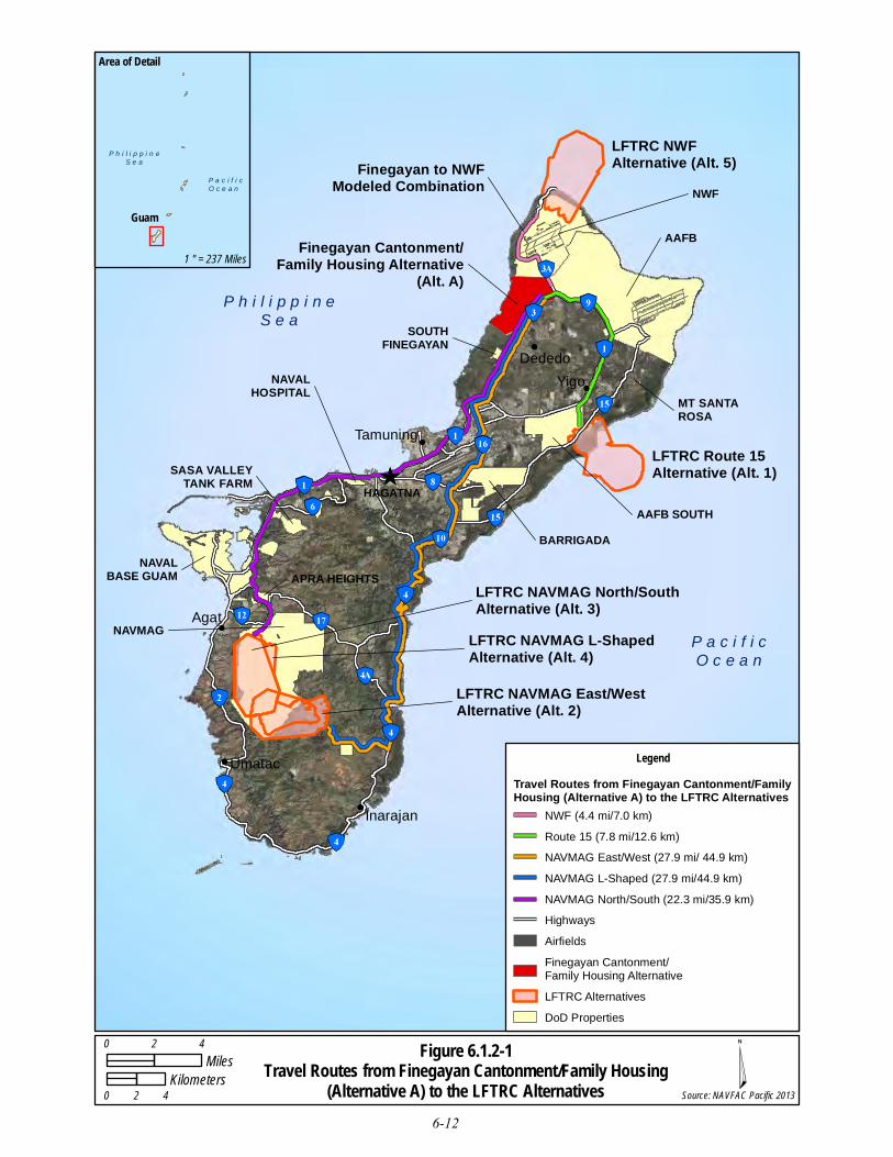
LFTRC NWFAlternative (Alt. 5)
LFTRC Route 15Alternative (Alt. 1)
LFTRC NAVMAG East/WestAlternative (Alt. 2)
LFTRC NAVMAG L-ShapedAlternative (Alt. 4)
LFTRC NAVMAG North/SouthAlternative (Alt. 3)
NWF
Finegayan Cantonment/Family Housing Alternative
(Alt. A)
SOUTHFINEGAYAN
AAFB
MT SANTAROSA
AAFB SOUTHBARRIGADA
NAVMAG
NAVALBASE GUAM
SASA VALLEYTANK FARM
NAVALHOSPITAL
DededoYigo
Tamuning
HAGATNA
Inarajan
Umatac
Agat
APRA HEIGHTS
Finegayan to NWFModeled Combination
Figure 6.1.2-1Travel Routes from Finegayan Cantonment/Family Housing
(Alternative A) to the LFTRC Alternatives
LegendTravel Routes from Finegayan Cantonment/FamilyHousing (Alternative A) to the LFTRC Alternatives
NWF (4.4 mi/7.0 km)Route 15 (7.8 mi/12.6 km)NAVMAG East/West (27.9 mi/ 44.9 km)NAVMAG L-Shaped (27.9 mi/44.9 km)NAVMAG North/South (22.3 mi/35.9 km)HighwaysAirfieldsFinegayan Cantonment/Family Housing AlternativeLFTRC AlternativesDoD Properties
P h i l i p p i n eS e a
P a c i f i cO c e a n
Guam
Area of Detail
1 " = 237 Miles
0 2 4Miles
0 2 4Kilometers
Source: NAVFAC Pacific 2013
P h i l i p p i n eS e a
P a c i f i cO c e a n
6-12

Guam and CNMI Military Relocation
(2012 Roadmap Adjustments) SEIS Draft April 2014
6-13
The impacts to off-base (external) roadway segments and intersections are summarized in Table 6.1.2-6.
Table 6.1.2-6. Summary of Additive Impacts to Ground Transportation Resources with the Finegayan
Cantonment/Family Housing (Alternative A) and any LFTRC Alternative
# Roadway Segments* Intersections
1 Route 1, from Route 3 to Route 34 (SI-M) Route 3 / 9 / Chalan Santa Anita (SI-M)
2 Route 1, from Route 34 to Route 16 (SI-M) Route 3 / Royal Palm Drive (SI-M)
3 Route 3, from Route 3A/9
to Finegayan Main Gate (SI-M) Route 1 / Route 3 (SI-M)
4 Route 3, from Finegayan Main Gate
To Finegayan Residential Gate (SI-M) Route 1 / Route 27 (SI-M)
5 Route 3, from Finegayan Residential Gate
To Route 28 (SI-M) Route 1 / Route 26 (SI-M)
6 Route 3, from Route 28
To South Finegayan Main Gate (SI-M) Route 16 / Route 27 (SI-M)
7 Route 3, from South Finegayan Main Gate
To Route 1 (SI-M) Route 16 / Route 10A (SI-M)
8 Route 28, from Chalan Balako to Route 3 (SI-M) Route 1 / Route 14A (SI-M)
9 NA Route 1 / Route 10A (SI-M)
Total 8, SI-M 9, SI-M
Legend: NA = not applicable, SI-M = significant but may be mitigated impact.
Notes:*Includes impacts to roadway segments in at least one direction during one (or both) weekday a.m. or p.m. peak hours.
Roadway Segment Operations. A capacity analysis was conducted to determine potential impacts to the
off-base (external) roadway network during weekday a.m. and p.m. peak hours. The volume to capacity
(v/c) ratio and LOS for each study roadway segment was compared to the baseline conditions to
determine if any significant impacts would occur. The detailed results of the roadway segment analysis
are provided in their entirety in Appendix F.
The addition of traffic generated by the proposed action would result in a potentially significant impact on
eight study roadway segments in at least one direction during the weekday a.m. and/or weekday p.m. peak
hours:
Route 1, from Route 3 to Route 34. This study roadway segment currently operates at acceptable LOS E
with a v/c ratio of 0.99 in the northbound/eastbound direction during the weekday p.m. peak hour under
Existing Conditions. This study roadway segment would operate at unacceptable LOS F with a v/c ratio
of 1.01 in the northbound/eastbound direction during the weekday p.m. peak hour under Year 2030
Baseline Conditions. Under Year 2030 Alternative A Conditions, this study roadway segment would
continue to operate at LOS F with a v/c ratio of 1.08. The proposed action would increase traffic on this
study roadway segment by approximately 180 vehicles during the weekday p.m. peak hour. This 6.9%
increase in traffic exceeds the 5.0% threshold of significance. Therefore, the proposed action would result
in a significant impact in the northbound/eastbound direction on this study roadway segment during the
weekday p.m. peak hour.

Guam and CNMI Military Relocation
(2012 Roadmap Adjustments) SEIS Draft April 2014
6-14
Route 1, from Route 34 to Route 16. This study roadway segment currently operates at acceptable
LOS E with a v/c ratio of 0.96 in the in the northbound/eastbound direction during the weekday
p.m. peak hour under Existing Conditions. This study roadway segment would operate at
acceptable LOS E with a v/c ratio of 0.97 in the northbound/eastbound direction during the
weekday p.m. peak hour under Year 2030 Baseline Conditions. Under Year 2030 Alternative A
Conditions, this study roadway segment would degrade to unacceptable LOS F with a v/c ratio of
1.08. Therefore, the proposed action would result in a significant impact in the
northbound/eastbound direction on this study roadway segment during the weekday p.m. peak
hour.
Route 3, from Route 3A/9 to Finegayan Main Gate. This study roadway segment currently
operates at acceptable LOS B with a v/c ratio of 0.64 in the southbound/westbound direction
during the weekday a.m. peak hour under Existing Conditions. This study roadway segment
would operate at acceptable LOS C with a v/c ratio of 0.75 in the southbound/westbound
direction during the weekday a.m. peak hour under Year 2030 Baseline Conditions. Under Year
2030 Alternative A Conditions, this study roadway segment would degrade to unacceptable LOS
F with a v/c ratio of 1.02. Therefore, the proposed action would result in a significant impact on
this study roadway segment in the southbound/westbound during the weekday a.m. peak hour.
Route 3, from Finegayan Main Gate to Finegayan Residential Gate. This study roadway segment
currently operates at unacceptable LOS F with a v/c ratio of 1.09 in the southbound/westbound
direction during the weekday a.m. peak hour under Existing Conditions. This study roadway
segment would operate at unacceptable LOS F with a v/c ratio of 1.24 in the
southbound/westbound direction during the weekday a.m. peak hour under Year 2030 Baseline
Conditions. Under Year 2030 Alternative A Conditions, this study roadway segment would
continue to operate at unacceptable LOS F with a v/c ratio of 1.41. The proposed action would
increase traffic on this study roadway segment by approximately 128 vehicles during the
weekday p.m. peak hour. This 12.3% increase in traffic exceeds the 5.0% threshold of
significance. Therefore, the proposed action would result in a significant impact on this study
roadway segment in the southbound/westbound direction during the weekday a.m. peak hour.
Route 3, from Finegayan Residential Gate to Route 28. This study roadway segment currently
operates at unacceptable LOS F with a v/c ratio of 1.23 in the southbound/westbound direction
during the weekday a.m. peak hour under Existing Conditions. This study roadway segment
would operate at LOS F with a v/c ratio of 1.36 in the southbound/westbound during the weekday
a.m. peak hour under Year 2030 Baseline Conditions. Under Year 2030 Alternative A
Conditions, this study roadway segment would continue to operate at unacceptable LOS F with a
v/c ratio of 1.61. The proposed action would increase the traffic on this study roadway segment
by approximately 183 vehicles during the weekday a.m. peak hour. This 15.4% increase in traffic
is greater than the 5.0% threshold of significance.
During the weekday p.m. peak hour, this study roadway segment currently operates at acceptable
LOS D with a v/c ratio 0.81 in the northbound/eastbound direction and acceptable LOS B with a
v/c ratio of 0.67 and southbound/westbound directions hour under Existing conditions. This study
roadway segment would continue to operate at acceptable LOS E with a v/c ratio of 0.91 and
LOS C with a v/c ratio of 0.74 in the northbound/eastbound and southbound/westbound
directions, respectively, during the weekday p.m. peak hour under Year 2030 Baseline
Conditions. Under Year 2030 Alternative A Conditions, this study roadway segment would
degrade to unacceptable LOS F with a v/c ratio of 1.21 in the northbound/eastbound direction and
1.08 in the southbound/westbound direction during the weekday p.m. peak hour. Therefore, the
Guam and CNMI Military Relocation
(2012 Roadmap Adjustments) SEIS Draft April 2014
6-15
proposed action would result in a significant impact on this study roadway segment in the
southbound/westbound directions during the weekday a.m. and p.m. peak hours, and in the
northbound/eastbound direction during the weekday p.m. peak hour.
Route 3, from Route 28 to South Finegayan Main Gate. This study roadway segment currently
operates at unacceptable LOS F with a v/c ratio of 1.07 in the southbound/westbound direction
during the weekday a.m. peak hour under Existing Conditions. This study roadway segment
would operate at unacceptable LOS F with a v/c ratio of 1.25 in the southbound/westbound
direction during the weekday a.m. peak hour under Year 2030 Baseline Conditions. Under Year
2030 Alternative A Conditions, this study roadway segment would continue to operate at
unacceptable LOS F with a v/c ratio of 1.36. The proposed action would increase traffic on this
study roadway segment by approximately 165 vehicles during the weekday p.m. peak hour. This
7.7% increase in traffic exceeds the 5.0% threshold of significance. Therefore, the proposed
action would result in a significant impact in the southbound/westbound direction on this study
roadway segment during the weekday a.m. peak hour.
Route 3, from South Finegayan Main Gate to Route 1. This study roadway segment currently
operates at unacceptable LOS F with a v/c ratio of 2.11 in the southbound/westbound direction
during the weekday a.m. peak hour under Existing Conditions. Construction of roadway
improvements (i.e., signalization of the intersections at Guam Regional Medical City and Okkodo
High School and provision of an additional southbound through lane on Route 3) would increase
the capacity of this roadway segment. However, despite the fact that these improvements would
be constructed prior to Year 2030, this study roadway segment would continue to operate at
unacceptable LOS F with a v/c ratio of 1.35 in the southbound/westbound direction during the
weekday a.m. peak hour under Year 2030 Baseline Conditions. Under Year 2030 Alternative A
Conditions, this study roadway segment would continue to operate at unacceptable LOS F with a
v/c ratio of 1.45. The proposed action would increase traffic on this study roadway segment by
approximately 161 vehicles during the weekday a.m. peak hour. This 7.0% increase in traffic
exceeds the 5.0% threshold of significance. Therefore, the proposed action would result in a
significant impact in the southbound/westbound direction on this study roadway segment during
the weekday a.m. peak hour.
Route 28, from Chalan Balako to Route 3. This study roadway segment currently operates at
unacceptable LOS F with a v/c ratio of 1.08 in the southbound/westbound direction during the
weekday a.m. peak hour under Existing Conditions. This study roadway segment would continue
to operate at LOS F with a v/c ratio of 1.48 in the southbound/westbound direction during the
weekday a.m. peak hour under Year 2030 Baseline Conditions. Under Year 2030 Alternative A
Conditions, this study roadway segment would continue to operate at LOS F with a v/c ratio of
1.56 in the southbound/westbound direction during the weekday a.m. peak hour. The proposed
action would increase the traffic on this study roadway segment by approximately 54 vehicles
during the weekday a.m. peak hour. This 5.1% increase in traffic is greater than the 5.0%
threshold of significance.
During the weekday p.m. peak hour, this study roadway segment currently operates at acceptable
LOS B with a v/c ratio of 0.68 in the northbound/eastbound direction under Existing Conditions.
This study roadway segment would operate at acceptable LOS E in the northbound/eastbound
direction during the weekday p.m. peak hour under Year 2030 Baseline Conditions. Under Year
2030 Alternative A Conditions, this study roadway segment would degrade to operate at
unacceptable LOS F with a v/c ratio of 1.04 in the northbound/eastbound direction during the
weekday p.m. peak hour. Therefore, the proposed action would result in a significant impact on

Guam and CNMI Military Relocation
(2012 Roadmap Adjustments) SEIS Draft April 2014
6-16
this study roadway segment in the southbound/westbound direction during the weekday a.m. peak
hour and in the northbound/eastbound direction during the weekday p.m. peak hour.
To reduce impacts to less than significant levels on these study roadway segments, the following potential
mitigation measures may be implemented:
Potential Mitigation Measure Fin-Roads-1: Provide additional eastbound travel lane. Widening of
the segment of Route 1, from Route 3 to Route 34, a distance of approximately 0.5 mile (1.0 km)
would be required to provide one additional travel lane in the eastbound direction. With
implementation of Potential Mitigation Measure Fin-Roads-1, level of service on this study
roadway segment would improve and the significant adverse impact would be mitigated to less
than significant levels. Therefore, this impact is considered to be significant but mitigable. (SI-M)
Potential Mitigation Measure Fin-Roads-2: Provide additional eastbound travel lane. Widening of
the segment of Route 1, from Route 34 to Route 16, a distance of approximately 0.06 mile (0.10
km), would be required to provide one additional travel lane in the eastbound direction. With
implementation of Potential Mitigation Measure Fin-Roads-2, level of service on this study
roadway segment would improve and the significant adverse impact would be mitigated to less
than significant levels. Therefore, this impact is considered to be significant but mitigable. (SI-M)
Potential Mitigation Measure Fin-Roads-3: Provide additional southbound travel lane. Widening
of the segment of Route 3, from Route 3A/9 to Finegayan Main Gate, a distance of approximately
0.5 mile (0.8 km), would be required to provide one additional travel lane in the southbound
direction. With implementation of Potential Mitigation Measure Fin-Roads-3, level of service on
this study roadway segment would improve and the significant adverse impact would be
mitigated to less than significant levels. Therefore, this impact is considered to be significant but
mitigable. (SI-M)
Potential Mitigation Measure Fin-Roads-4: Provide additional southbound travel lane. Widening
of the segment of Route 3, from Finegayan Main Gate to Finegayan Commercial Gate, a distance
of approximately 1.75 miles (2.82 km), would be required to provide one additional travel lane in
the southbound direction. With implementation of Potential Mitigation Measure Fin-Roads-4,
level of service on this study roadway segment would improve and the significant adverse impact
would be mitigated to less than significant levels. Therefore, this impact is considered to be
significant but mitigable. (SI-M)
Potential Mitigation Measure Fin-Roads-5: Provide additional travel lanes in the northbound and
southbound directions. Widening of the segment of Route 3, from Finegayan Commercial Gate to
Route 28, a distance of approximately 0.5 mile (0.8 km), would be required to provide one
additional travel lane in the northbound and southbound directions. With implementation of
Potential Mitigation Measure Fin-Roads-5, level of service on this study roadway segment would
improve and the significant adverse impact would be mitigated to less than significant levels.
Therefore, this impact is considered to be significant but mitigable. (SI-M)
Potential Mitigation Measure Fin-Roads-6: Provide additional southbound travel lane. Widening
of the segment of Route 3, from Route 28 to South Finegayan Main Gate, a distance of
approximately 0.87 mile (1.40 km), would be required to provide one additional travel lane in the
southbound direction. With implementation of Potential Mitigation Measure Fin-Roads-6, level
of service on this study roadway segment would improve and the significant adverse impact
would be mitigated to less than significant levels. Therefore, this impact is considered to be
significant but mitigable. (SI-M)
Guam and CNMI Military Relocation
(2012 Roadmap Adjustments) SEIS Draft April 2014
6-17
Potential Mitigation Measure Fin-Roads-7: Provide additional southbound travel lane. Widening
of the segment of Route 3, from South Finegayan Main Gate to Route 1, a distance of
approximately 1.67 miles (2.68 km), would be required to provide one additional travel lane in
the southbound direction. With implementation of Potential Mitigation Measure Fin-Roads-7,
level of service on this study roadway segment would improve and the significant adverse impact
would be mitigated to less than significant levels. Therefore, this impact is considered to be
significant but mitigable. (SI-M)
Potential Mitigation Measure Fin-Roads-8: Provide additional eastbound and westbound travel
lanes. Widening of the segment of Route 28, from Chalan Balako to Route 3, a distance of
approximately 0.97 mile (1.56 km), would be required to provide one additional travel lane in the
eastbound and westbound directions. With implementation of Potential Mitigation Measure Fin-
Roads-8, level of service on this study roadway segment would improve and the significant
adverse impact would be mitigated to less than significant levels. Therefore, this impact is
considered to be significant but mitigable. (SI-M)
The measures needed to mitigate the impacted roadway segments would be feasible at all eight locations.
The final list of implementable mitigation measures will be dependent on the selected alternative or
combination of alternatives and based on project-level technical studies to be conducted after the
alternative or combination of alternatives is selected. FHWA will conduct all NEPA documentation
efforts and any associated resource consultations as specific mitigation measures are proposed.
Intersection Operations. Intersection analysis was conducted to determine potential impacts to the off-
base (external) intersections during weekday a.m. and p.m. peak hours. The LOS for each study
intersection was compared to the baseline conditions to determine if any significant impacts would occur.
An impact summary is provided in Table 6.1.2-6. The detailed results of the intersection analysis are
provided in their entirety in Appendix F.
The addition of traffic generated by the proposed action would potentially result in a significant impact at
nine study intersections during the weekday a.m. and/or weekday p.m. peak hours.
Route 3 / 9 / Chalan Santa Anita. This two-way stop-controlled study intersection currently
operates at acceptable LOS C with 21.9 seconds of delay and would continue to operate at
acceptable LOS E with 37.7 seconds of delay during the weekday a.m. peak hour under Existing
Conditions and Year 2030 Baseline Conditions, respectively. Under Year 2030 Alternative A
Conditions, this study intersection would degrade to unacceptable LOS F with greater than 180.0
seconds of delay. Therefore, the proposed action would result in a significant impact on this study
intersection during the weekday a.m. peak hour.
Route 3 / Royal Palm Drive. This two-way stop-controlled study intersection currently operates at
acceptable LOS C with 16.3 seconds of delay and would operate at acceptable LOS E with 36.4
seconds of delay during the weekday a.m. peak hour under Existing Conditions and Year 2030
Baseline Conditions, respectively. Under Year 2030 Alternative A Conditions, this study
intersection would degrade to unacceptable LOS F with 57.8 seconds of delay. Therefore, the
proposed action would result in a significant impact on this study intersection during the weekday
a.m. peak hour.
Route 1 / Route 3. This signalized study intersection currently operates at LOS F and would
continue to operate at unacceptable LOS F with greater than 180.0 seconds of delay during the
weekday a.m. peak hour under Existing Conditions and Year 2030 Baseline Conditions,
respectively. During the weekday p.m. peak hour this study intersection currently operates at LOS
Guam and CNMI Military Relocation
(2012 Roadmap Adjustments) SEIS Draft April 2014
6-18
E with 70.8 seconds of delay and would continue to operate at LOS E with 63.4 seconds of delay
during the weekday a.m. and p.m. peak hours, respectively, under Existing Conditions and Year
2030 Baseline Conditions, respectively. Under Year 2030 Alternative A Conditions, this study
intersection would continue to operate at LOS F with greater than 180.0 seconds of delay and the
proposed action would add more than 50 vehicles to this poorly performing intersection during
the weekday a.m. peak hour. During the weekday p.m. peak hour the intersection would degrade
to operate at unacceptable LOS F with 90.1 seconds of delay. Therefore, the proposed action
would result in a significant impact on this study intersection during the weekday a.m. and p.m.
peak hours.
Route 1 / Route 27. This signalized study intersection currently operates at acceptable LOS E
with 70.3 seconds of delay and would operate at unacceptable LOS F with 118.3 seconds of delay
during the weekday a.m. peak hour under Existing Conditions and Year 2030 Baseline
Conditions, respectively. Under Year 2030 Alternative A Conditions, this study intersection
would continue to operate at unacceptable LOS F with 118.5 seconds of delay. The proposed
action would add more than 50 vehicles to this poorly performing intersection. Therefore, the
proposed action would result in a significant impact on this study intersection during the weekday
a.m. peak hour.
Route 1 / Route 26. This signalized study intersection currently operates at acceptable LOS C
with 27.9 seconds of delay and would operate at unacceptable LOS F with 87.6 seconds of delay
during the weekday p.m. peak hour under Existing Conditions and Year 2030 Baseline
Conditions, respectively. Under Year 2030 Alternative A Conditions, this study intersection
would continue to operate at unacceptable LOS F with 89.4 seconds of delay. The proposed
action would add more than 50 vehicles to this poorly performing intersection. Therefore, the
proposed action would result in a significant impact on this study intersection during the weekday
p.m. peak hour.
Route 16 / Route 27. This signalized study intersection currently operates at acceptable LOS D
with 50.1 seconds of delay and acceptable LOS E with 71.2 seconds of delay during the weekday
a.m. and p.m. peak hours, respectively, under Existing Conditions. This signalized study
intersection would operate at unacceptable LOS F with greater than 180.0 seconds of delay and
154.7 seconds of delay during the weekday a.m. and p.m. peak hours, respectively under Year
2030 Baseline Conditions. Under Year 2030 Alternative A Conditions, this study intersection
would continue to operate at unacceptable LOS F with greater than 180.0 seconds of delay and
159.0 seconds of delay during the weekday a.m. and p.m. peak hours, respectively. The project
would add more than 50 vehicles to this poorly performing intersection. Therefore, the proposed
action would result in a significant impact on this study intersection during the weekday a.m. and
p.m. peak hours.
Route 16 / Route 10A. This signalized study intersection currently operates at unacceptable LOS
F and would continue to operate at unacceptable LOS F with greater than 180.0 seconds of delay
during the weekday a.m. peak hour under Existing Conditions and Year 2030 Baseline
Conditions, respectively. Under Year 2030 Alternative A Conditions, this study intersection
would continue to operate at unacceptable LOS F with greater than 180.0 seconds of delay. The
project would add more than 50 vehicles to this poorly performing intersection. Therefore, the
proposed action would result in a significant impact on this study intersection during the weekday
a.m. peak hour.
Route 1 / Route 14A. This signalized study intersection currently operates at unacceptable LOS F
with 156.1 seconds of delay during the weekday p.m. peak hour under Existing Conditions. This

Guam and CNMI Military Relocation
(2012 Roadmap Adjustments) SEIS Draft April 2014
6-19
study intersection would continue to operate at unacceptable LOS F with greater than 180.0
seconds of delay during the weekday p.m. peak hour under Existing Conditions and Year 2030
Baseline Conditions, respectively. Under Year 2030 Alternative A Conditions, this study
intersection would continue to operate at unacceptable LOS F with greater than 180.0 seconds of
delay. The proposed action would add more than 50 vehicles to this poorly performing
intersection. Therefore, the proposed action would result in a significant impact on this study
intersection during the weekday p.m. peak hour.
Route 1 / Route 10A. This signalized study intersection currently operates at acceptable LOS E
with 62.6 seconds of delay and would operate at unacceptable LOS F with 139.3 seconds of delay
during the weekday p.m. peak hour under Existing Conditions and Year 2030 Baseline
Conditions, respectively. Under Year 2030 Alternative A Conditions, this study intersection
would continue to operate at unacceptable LOS F with 144.7 seconds of delay. The proposed
action would add more than 50 vehicles to this poorly performing intersection. Therefore, the
proposed action would result in a significant impact on this study intersection during the weekday
p.m. peak hour.
To reduce impacts to less than significant levels on these study intersections, the following potential
mitigation measures may be implemented:
Potential Mitigation Measure Fin-Int-1: Combine Route 3, 3A and 9 into one signalized
intersection. Combine Route 3, 3A and 9 into one signalized intersection with the following
configuration:
o Northbound (Chalan Santa Anita): one shared left/through/right-turn lane
o Southbound (Route 3A): One right-turn lane with 150-foot (46-m) storage pocket
o Eastbound (Route 3) and westbound (Route 8): one left-turn lane with 150-foot (46-m)
storage pocket, one through lane, one shared through/right-turn lane
With implementation of Potential Mitigation Measure Fin-Int-1, level of service at this study
intersection would improve and the significant impact would be mitigated to less than significant
levels. The new intersection would operate at LOS A (7.6 seconds of delay) and LOS A (5.6
seconds of delay) during the weekday a.m. and p.m. peak hours, respectively. Therefore, this
impact is considered to be significant but mitigable. (SI-M)
Potential Mitigation Measure Fin-Int-2: Add exclusive eastbound right-turn lane on Royal Palm
Drive. Provide an exclusive eastbound right-turn lane on Royal Palm Drive with 100-foot (30-m)
storage pocket. With implementation of Potential Mitigation Measure Fin-Int-2, level of service
at this study intersection would improve and the significant impact would be mitigated to less
than significant levels. The Route 3/Royal Palm Drive two-way stop-controlled intersection
would operate at LOS E (48.0 seconds of delay) and LOS C (15.6 seconds of delay) during the
weekday a.m. and p.m. peak hours, respectively. Therefore, this impact is considered to be
significant but mitigable. (SI-M)
Potential Mitigation Measure Fin-Int-3: Add second eastbound left-turn lane and exclusive
westbound right-turn lane on Route 1. Provide a second eastbound right-turn lane and an
exclusive westbound right-turn lane with 200 foot (61 m) storage pocket on Route 1. With
implementation of Potential Mitigation Measure Fin-Int-3, operations at this signalized
intersection would improve and the significant impact would be mitigated to less than significant
levels. The Route 1/Route 3 signalized intersection would operate at LOS F (127.8 seconds of
delay) and LOS B (14.9 seconds of delay) during the weekday a.m. and p.m. peak hours,
respectively. Although the intersection would continue to operate at LOS F during the weekday

Guam and CNMI Military Relocation
(2012 Roadmap Adjustments) SEIS Draft April 2014
6-20
a.m. peak hour, average intersection delay under Year 2030 Alternative A with LFTRC at NWF
(Alternative 5) Conditions would be less than the average intersection delay under Year 2030
Baseline Conditions. Therefore, this impact is considered to be significant but mitigable. (SI-M)
Potential Mitigation Measure Fin-Int-4: Restripe southbound (Salisbury Street) approach and
provide northbound right-turn overlap phase on Route 27. Restripe the southbound (Salisbury
Street) approach to one left-turn lane with 80 feet (24 m) storage length, one through lane and one
right-turn lane with 50 feet (15 m) storage length. Provide a right-turn overlap phase on the
northbound (Route 27) approach. With implementation of Potential Mitigation Measure Fin-Int-4,
level of service at this signalized intersection would improve and the significant impact would be
mitigated to less than significant levels. The Route 1/Route 27 signalized intersection would
improve to operate at LOS F (81.7 seconds of delay) and LOS D (38.8 seconds of delay) during
the weekday a.m. and p.m. peak hours, respectively. Although the intersection would continue to
operate at LOS F during the weekday a.m. peak hour, average intersection delay under Year 2030
Alternative A with LFTRC Alternative 5 Conditions would be less than the average intersection
delay under Year 2030 Baseline Conditions. Therefore, this impact is considered to be significant
but mitigable. (SI-M)
Potential Mitigation Measure Fin-Int-5: Provide northbound right-turn overlap phase on Route
26. Provide a right-turn overlap phase on the northbound (Route 26) approach. With
implementation of Potential Mitigation Measure Fin-Int-5, level of service at this signalized
intersection would improve and the significant impact would be mitigated to less than significant
levels. The Route 1/Route 26 signalized intersection would operate at LOS D (37.2 seconds of
delay) and LOS E (63.8 seconds of delay) during the weekday a.m. and p.m. peak hours,
respectively. Therefore, this impact is considered to be significant but mitigable. (SI-M)
Potential Mitigation Measure Fin-Int-6: Convert westbound right-turn lane to through lane and
provide exclusive westbound and eastbound right-turn lanes on Route 27. Widen and reconfigure
the westbound (Route 27) approach. Convert the existing right-turn lane to a westbound (Route
27) through lane and add an exclusive westbound (Route 27) right-turn lane with 150 feet (46 m)
storage length. Provide an exclusive eastbound (Route 27) right-turn lane with 150 feet (46 m)
storage length. With implementation of Potential Mitigation Measure Fin-Int-8, level of service at
this signalized intersection would improve and the significant impact would be mitigated to less
than significant levels. The Route 16/Route 27 signalized intersection would operate at LOS F
(116.0 seconds of delay) and LOS F (117.6 seconds of delay) during the weekday a.m. and p.m.
peak hours, respectively. Although the intersection would continue to operate at LOS F during the
weekday a.m. and p.m. peak hours, average intersection delay under Year 2030 Alternative A
with LFTRC Alternative 5 Conditions would be less than the average intersection delay under
Year 2030 Baseline Conditions. Therefore, this impact is considered to be significant but
mitigable. (SI-M)
Potential Mitigation Measure Fin-Int-7: Provide free southbound right-turn on Route 16. Provide
a free right-turn on the southbound (Route 16) approach. With implementation of Potential
Mitigation Measure Fin-Int-7, operations at intersection would improve and the significant impact
would be mitigated to less than significant levels. The Route 16/Route 10A signalized
intersection would operate at LOS F (greater than 180.0 seconds of delay) during the weekday
a.m. peak hour. Although the intersection would continue to operate at LOS F during the
weekday a.m. peak hour, average intersection delay under Year 2030 Alternative A with LFTRC
(Alternative 5 Conditions would be less than the average intersection delay under Year 2030
Baseline Conditions. Therefore, this impact is considered to be significant but mitigable. (SI-M)
Guam and CNMI Military Relocation
(2012 Roadmap Adjustments) SEIS Draft April 2014
6-21
Potential Mitigation Measure Fin-Int-8: Provide exclusive eastbound right-turn lane on Route 1.
Widen and reconfigure the eastbound (Route 1) approach. Provide an exclusive eastbound (Route
1) right-turn lane with 150 feet (46 m) storage length. With implementation of Potential
Mitigation Measure Fin-Int-8, operations at this signalized intersection would improve and the
significant impact would be mitigated to less than significant levels. The Route 1/Route 14A
signalized intersection would operate at LOS F (158.1 seconds of delay) during the weekday p.m.
peak hour. Although the intersection would continue to operate at LOS F during the weekday
p.m. peak hour, average intersection delay under Year 2030 Alternative A with LFTRC
Alternative 5 Conditions would be less than the average intersection delay under Year 2030
Baseline Conditions. Therefore, this impact is considered to be significant but mitigable. (SI-M)
Potential Mitigation Measure Fin-Int-9: Provide exclusive northbound right-turn lane and overlap
phase on Route 1. Provide an exclusive right-turn lane with 150 feet (46 m) storage length and
provide an overlap phase on the northbound (Route 27) approach. With implementation of
Potential Mitigation Measure Fin-Int-9, level of service at this intersection would improve and the
significant impact would be mitigated to less than significant levels. The Route 1/Route 10A
signalized intersection would operate at acceptable LOS C (25.8 seconds of delay) and acceptable
LOS D (40.6 seconds of delay) during the weekday a.m. and p.m. peak hours, respectively.
Therefore, this impact is considered to be significant but mitigable. (SI-M)
The measures needed to mitigate the impacted intersections would be feasible at all nine locations. The
final list of implementable mitigation measures will be dependent on the selected alternative or
combination of alternatives and based on project-level technical studies, to be conducted after the
alternative or combination of alternatives is selected. FHWA will conduct all NEPA documentation
efforts and any associated resource consultations as specific mitigation measures are proposed.
Transit Conditions. While none of the proposed cantonment/family housing or LFTRC alternatives are
directly served by fixed-route transit, the proposed action may have a minor impact on the operation of
Grey Line #1 by increasing travel delay at the Route 1/Route 3 intersection and the Route 1/Route 26
intersection during the weekday a.m. and p.m. peak hours. However, the increase in travel time would not
be substantial and would not be expected to negatively effect on-time performance (e.g., substantially
increase transit headways or reduce frequency). Additionally, implementation of Potential Mitigation
Measure Fin-Int-3 and Potential Mitigation Measure Fin-Int-5 would improve operations and reduce
average delay at these locations compared to Year 2030 Baseline Conditions.
Pedestrian and Bicycle Conditions. The proposed action would result in a significant increase in vehicular
traffic on Route 3, whose northern portions near the main cantonment lack shoulders or sidewalks. This
increases the potential for collisions with bicyclists and pedestrians at the locations where they are likely
to be present. Specifically, Artero Drive (Finegayan Elementary School and McDonald’s) and Okkodo
High School.
Finegayan/South Finegayan Cantonment/Family Housing Alternative B with Route 15 LFTRC
Alternative 1
The travel demand modeling methodology for the combination of alternatives was defined and directed
by the DoD and the FHWA to provide detailed off-base (external) roadway and intersection analysis for
one representative pairing (the modeled combination) of each cantonment/family housing alternative with
one of the LFTRC site alternatives. The modeled combination for Alternative B involved a pairing with
LFTRC Alternative 2 or 4 (see Section 3.12 in Chapter 3). Modeling results for this scenario indicate that
weekday a.m. peak hour vehicle traffic related to the proposed action is generated solely by operations at
Guam and CNMI Military Relocation
(2012 Roadmap Adjustments) SEIS Draft April 2014
6-22
the cantonment/family housing area. LFTRC-related traffic would occur prior to the start of weekday a.m.
peak hour (8:00 a.m.) and may coincide with the weekday p.m. peak hour (4:30 p.m. to 5:30 p.m.) (see
Section 5.1.12 in Chapter 5). Operations of the LFTRC would increase traffic on the off-base (external)
roadway segments and intersections that comprise the most direct route between the main cantonment
gate and the LFTRC gates, by approximately 38 vehicles (measured in passenger car equivalents) (see
Table 5.1.12-2). LFTRC-related traffic represents an insubstantial amount of traffic (less than 5%) along
the route. This minimal incremental increase in traffic volumes would not adversely affect level of service
on roadways or at intersections along the route. The relative contribution from LFTRC traffic to the off-
base (external) roadway segments and intersections of each cantonment/family housing alternative would
be minimal and would not vary appreciably with any LFTRC pairing (Alternative 1, 2, 3, 4, or 5).
Therefore, the impacts to off-base (external) roadway segments and intersections would be essentially the
same for Alternative B with Alternative 1, Alternative B with Alternative 2, 3, or 4, and Alternative B
with Alternative 5. A qualitative discussion of the potential effects of LFTRC-related traffic is provided
for each combination.
Pairing Alternative B with Alternative 1 may result in a slight increase (less than 5%) in vehicles on
roadway segments and at intersections along the most direct route between the Alternative B Main Gate
and the Alternative 1 gate, and a slight decrease in vehicles compared to the modeled combination of
Alternative B Main Gate and the Alternative 2 or 4 gate (Figure 6.1.2-2). This minimal incremental
increase or decrease in traffic volumes would not adversely affect level of service on roadways or at
intersections along the route.
The impacts to off-base (external) roadway segments and intersections are summarized in Table 6.1.2-7.
Table 6.1.2-7. Summary of Additive Impacts to Ground Transportation Resources with the
Finegayan/South Finegayan Cantonment/Family Housing (Alternative B) with any LFTRC
# Roadway Segments* Intersections
1 Route 1, from Route 3 to Route 34 (SI-M) Route 3 / 9 / Chalan Santa Anita (SI-M)
2 Route 1, from Route 34 to Route 16 (SI-M) Route 3 / Royal Palm Drive (SI-M)
3 Route 3, from Route 3A/9
to Finegayan Main Gate (SI-M) Route 15 / Chalan Lajuna (SI)**
4 Route 3, from Finegayan Main Gate
To Finegayan Residential Gate (SI-M) Route 1 / Route 3 (SI-M)
5 Route 3, from Finegayan Residential Gate
To Route 28 (SI-M) Route 1 / Route 27 (SI-M)
6 Route 3, from Route 28
To South Finegayan Main Gate (SI-M) Route 1 / Route 26 (SI-M)
7 Route 3, from South Finegayan Main Gate
To Route 1 (SI-M) Route 16 / Route 27 (SI-M)
8 Route 16, from Route 27 to Route 10A (SI)** Route 16 / Route 10A (SI-M)
9 Route 28, from Chalan Balako to Route 3 (SI-M) Route 15 / Route 26 (SI-M)**
10 Route 16, from Route 10A
To Barrigada Main Gate (SI)** Route 1 / Route 14A (SI-M)
11 NA Route 1 / Route 10A (SI-M)
Total 10 (2 SI, 8 SI-M) 11 (1 SI, 10 SI-M)
Legend: NA indicates not applicable. SI indicates significant impact. SI-M indicates significant but may be mitigated impact. Notes: * Includes impacts to roadway segments in at least one direction during one (or both) weekday a.m. or p.m. peak hours. ** Indicates an impact that would not occur under Year 2030 Alternative A Conditions.
LFTRC NWFAlternative (Alt. 5)
LFTRC Route 15Alternative (Alt. 1)
LFTRC NAVMAG East/WestAlternative (Alt. 2)
LFTRC NAVMAG L-ShapedAlternative (Alt. 4)
LFTRC NAVMAG North/SouthAlternative (Alt. 3)
NWF
Finegayan/South FinegayanCantonment/Family Housing
Alternative (Alt. B)AAFB
MT SANTAROSA
AAFB SOUTHBARRIGADA
NAVMAG
NAVALBASE GUAM
SASA VALLEYTANK FARM
NAVALHOSPITAL
DededoYigo
Tamuning
HAGATNA
Inarajan
Umatac
Agat
APRA HEIGHTS
Finegayan/South Finegayan to NAVMAG East/West and L-Shaped Alternatives Modeled Combination
Figure 6.1.2-2Travel Routes from Finegayan/South Finegayan Cantonment/
Family Housing (Alternative B) to the LFTRC Alternatives
LegendTravel Routes from Finegayan/South FinegayanCantonment/Family Housing (Alternative B)to the LFTRC Alternatives
NWF (4.4 mi/7 km)Route 15 (7.8 mi/12.6 kmi)NAVMAG East-West (27.9 mi/44.9 km)NAVMAG L-Shaped (27.9 mi/44.9 km)NAVMAG North-South (22.3 mi/35.9 km)HighwaysAirfieldsFinegayan/South Finegayan Cantonment/Family Housing AlternativeLFTRC AlternativesDoD Properties
P h i l i p p i n eS e a
P a c i f i cO c e a n
Guam
Area of Detail
1 " = 237 Miles
0 2 4Miles
0 2 4Kilometers
Source: NAVFAC Pacific 2013
P h i l i p p i n eS e a
P a c i f i cO c e a n
6-23

Guam and CNMI Military Relocation
(2012 Roadmap Adjustments) SEIS Draft April 2014
6-24
Roadway Segment Operations. A capacity analysis was conducted to determine potential impacts to the
off-base (external) roadway network during weekday a.m. and p.m. peak hours. The LOS for each study
roadway segment was compared to the baseline conditions to determine if any significant impacts would
occur. The detailed results of the roadway segment analysis are provided in their entirety in Appendix F.
The addition of traffic generated by the proposed action would potentially result in a significant impact on
ten study roadway segments in at least one direction during the weekday a.m. and/or weekday p.m. peak
hours.
Route 1, from Route 3 to Route 34. This study roadway segment currently operates at LOS E
with a v/c ratio of 0.99 in the northbound/eastbound direction during the weekday p.m. peak hour
under Existing Conditions. This study roadway segment would operate at LOS F with a v/c ratio
of 1.01 in the northbound/eastbound direction during the weekday p.m. peak hour under Year
2030 Baseline Conditions. Under Year 2030 Alternative B Conditions, this study roadway
segment would continue to operate at LOS F with a v/c ratio of 1.11. The proposed action would
increase traffic on this study roadway segment by approximately 250 vehicles during the
weekday p.m. peak hour. This 9.3% increase in traffic exceeds the 5.0% threshold of significance.
Therefore, the proposed action would result in a significant impact in the northbound/eastbound
direction on this study roadway segment during the weekday p.m. peak hour. A similar impact
was identified on this study roadway segment under Year 2030 Alternative A Conditions.
Route 1, from Route 34 to Route 16. This study roadway segment currently operates at acceptable
LOS E with a v/c ratio of 0.96 in the in the northbound/eastbound direction during the weekday
p.m. peak hour under Existing Conditions. This study roadway segment would operate at
acceptable LOS E with a v/c ratio of 0.97 in the northbound/eastbound direction during the
weekday p.m. peak hour under Year 2030 Baseline Conditions. Under Year 2030 Alternative B
Conditions, this study roadway segment would degrade to unacceptable LOS F with a v/c ratio of
1.07. Therefore, the proposed action would result in a significant impact in the
northbound/eastbound direction on this study roadway segment during the weekday p.m. peak
hour. A similar impact was identified on this study roadway segment under Year 2030
Alternative A Conditions.
Route 3, from Route 3A/9 to Finegayan Main Gate. This study roadway segment currently
operates at acceptable LOS B with a v/c ratio of 0.64 and acceptable LOS A with a v/c ratio of
0.42 in the southbound/westbound direction during the weekday a.m. and p.m. peak hours,
respectively, under Existing Conditions. This study roadway segment would operate at acceptable
LOS C with a v/c ratio of 0.75 and LOS A with a v/c ratio of 0.52 in the southbound/westbound
direction during the weekday a.m. and p.m. peak hours, respectively, under Year 2030 Baseline
Conditions. Under Year 2030 Alternative B Conditions, this study roadway segment would
degrade to unacceptable LOS F with a v/c ratio of 1.05 and 1.04 during the weekday a.m. and
p.m. peak hours, respectively. Therefore, the proposed action would result in a significant impact
on this study roadway segment in the southbound/westbound during the weekday a.m. and p.m.
peak hours. A similar impact was identified on this study roadway segment during the weekday
a.m. peak hour under Year 2030 Alternative A Conditions. An impact was not identified during
the weekday p.m. peak hour Year 2030 Alternative A Conditions.
Route 3, from Finegayan Main Gate to Finegayan Residential Gate. This study roadway segment
currently operates at acceptable LOS A with a v/c ratio of 0.45 and 0.60 in the
northbound/eastbound direction during the weekday a.m. and p.m. peak hours, respectively under
Existing Conditions. This study roadway segment would continue to operate at acceptable LOS A
Guam and CNMI Military Relocation
(2012 Roadmap Adjustments) SEIS Draft April 2014
6-25
with a v/c ratio of 0.49 during the weekday a.m. peak hour and would operate at acceptable LOS
B with a v/c ratio of 0.68 during the weekday a.m. and p.m. peak hours, respectively, in the
northbound/eastbound direction under Year 2030 Baseline Conditions. Under Year 2030
Alternative B Conditions, this roadway segment would degrade to operate at unacceptable LOS F
with a v/c ratio of 1.15 and 1.10 during the weekday a.m. and p.m. peak hours, respectively.
This study roadway segment currently operates at unacceptable LOS F with a v/c ratio of 1.09
and acceptable LOS A with a v/c ratio of 0.51 in the southbound/westbound direction during the
weekday a.m. and p.m. peak hours, respectively under Existing Conditions. This study roadway
segment would continue to operate at unacceptable LOS F with a v/c ratio of 1.24 in the during
the weekday a.m. peak hour, and at acceptable LOS A in the southbound/westbound direction
during the weekday a.m. and p.m. peak hours, respectively, under Year 2030 Baseline
Conditions. Under Year 2030 Alternative B Conditions, this study roadway segment would
continue to operate at unacceptable LOS F with a v/c ratio of 1.41 and would degrade to operate
at LOS F with a v/c ratio of 1.13 in the southbound/westbound direction during the weekday a.m.
and p.m. peak hours, respectively. The proposed action would increase traffic on this study
roadway segment by approximately 148 vehicles during the weekday p.m. peak hour. This 13.9%
increase in traffic exceeds the 5.0% threshold of significance. Therefore, the proposed action
would result in a significant impact on this study roadway segment in the northbound/eastbound
and southbound/westbound directions during the weekday a.m. and p.m. peak hours.
A similar impact was identified in the southbound/westbound direction on this study roadway
segment during the weekday a.m. peak hour under Year 2030 Alternative A Conditions. An
impact was not identified in the northbound/eastbound direction during either the weekday a.m.
or p.m. peak hours, nor in the southbound/westbound direction during the weekday p.m. peak
hour under Year 2030 Alternative A Conditions.
Route 3, from Finegayan Residential Gate to Route 28. This study roadway segment currently
operates at acceptable LOS B with a v/c ratio of 0.67 and LOS D with a v/c ratio of 0.81 in the
northbound/eastbound direction during the weekday a.m. and p.m. peak hours, respectively under
Existing Conditions. This study roadway segment would operate at acceptable LOS B with a v/c
ratio of 0.70 and LOS E with a v/c ratio of 0.90 in the northbound/eastbound direction during the
weekday a.m. and p.m. peak hours, respectively, in the northbound/eastbound direction under
Year 2030 Baseline Conditions. Under Year 2030 Alternative B Conditions, this roadway
segment would degrade to operate at unacceptable LOS F with a v/c ratio of 1.41 and 1.29 during
the weekday a.m. and p.m. peak hours, respectively.
This study roadway segment currently operates at unacceptable LOS F with a v/c ratio of 1.23
and acceptable LOS B with a v/c ratio of 0.67 in the southbound/westbound direction during the
weekday a.m. and p.m. peak hours, respectively under Existing Conditions. This study roadway
segment would operate at unacceptable LOS F with a v/c ratio of 1.36 during the weekday a.m.
peak hour, and at acceptable LOS C with a v/c ratio of 0.74 during the weekday p.m. peak hour in
the southbound/westbound direction under Year 2030 Baseline Conditions. Under Year 2030
Alternative B Conditions, this study roadway segment would continue to operate at unacceptable
LOS F with a v/c ratio of 1.55 and would degrade to operate at LOS F with a v/c ratio of 1.44 in
the southbound/westbound direction during the weekday a.m. and p.m. peak hours, respectively.
The proposed action would increase traffic on this study roadway segment by approximately 143
vehicles during the weekday p.m. peak hour. This 12.5% increase in traffic exceeds the 5.0%
threshold of significance. Therefore, the proposed action would result in a significant impact on
Guam and CNMI Military Relocation
(2012 Roadmap Adjustments) SEIS Draft April 2014
6-26
this study roadway segment in the northbound/eastbound and southbound/westbound directions
during the weekday a.m. and p.m. peak hours.
A similar impact was identified in the southbound/westbound direction on this study roadway
segment during the weekday a.m. peak hour under Year 2030 Alternative A Conditions. An
impact was not identified in the northbound/eastbound direction during either the weekday a.m.
or p.m. peak hours, nor in the southbound/westbound direction during the weekday p.m. peak
hour under Year 2030 Alternative A Conditions.
Route 3, from Route 28 to South Finegayan Main Gate. This study roadway segment currently
operates at unacceptable LOS F with a v/c ratio of 1.07 in the southbound/westbound direction
during the weekday a.m. peak hour under Existing Conditions. This study roadway segment
would continue to operate at unacceptable LOS F with a v/c ratio of 1.25 in the
southbound/westbound direction during the weekday a.m. peak hour under Year 2030 Baseline
Conditions. Under Year 2030 Alternative B Conditions, this study roadway segment would
continue to operate at unacceptable LOS F with a v/c ratio of 1.36 in the southbound/westbound
direction. The proposed action would increase traffic on this study roadway segment by
approximately 166 vehicles during the weekday p.m. peak hour. This 7.7% increase in traffic
exceeds the 5.0% threshold of significance. Therefore, the proposed action would result in a
significant impact in the southbound/westbound direction on this study roadway segment during
the weekday a.m. peak hour. A similar impact was identified on this study roadway segment
under Year 2030 Alternative A Conditions.
Route 3, from South Finegayan Main Gate to Route 1. This study roadway segment currently
operates at unacceptable LOS F with a v/c ratio of 2.11 in the southbound/westbound direction
during the weekday a.m. peak hour under Existing Conditions. Construction of roadway
improvements (i.e., signalization of the intersections at Guam Regional Medical City and Okkodo
High School and provision of an additional southbound through lane on Route 3) would increase
the capacity of this roadway segment. However, despite the fact that these improvements would
be constructed prior to Year 2030, this study roadway segment would operate at unacceptable
LOS F with a v/c ratio of 1.35 in the southbound/westbound direction during the weekday a.m.
peak hour under Year 2030 Baseline Conditions. Under Year 2030 Alternative B Conditions, this
study roadway segment would continue to operate at unacceptable LOS F with a v/c ratio of 1.46.
The proposed action would increase traffic on this study roadway segment by approximately 168
vehicles during the weekday a.m. peak hour. This 7.3% increase in traffic exceeds the 5.0%
threshold of significance. Therefore, the proposed action would result in a significant impact in
the southbound/westbound direction on this study roadway segment during the weekday a.m.
peak hour. A similar impact was identified on this study roadway segment under Year 2030
Alternative A Conditions.
Route 16, from Route 27 to Route 10A. This study roadway segment currently operates at
acceptable LOS D with a v/c ratio of 0.84 in the northbound/eastbound direction during the
weekday a.m. peak hour under Existing Conditions. This study roadway segment would operate
at acceptable LOS E with a v/c ratio of 0.98 in the northbound/eastbound during the weekday
p.m. peak hour under Year 2030 Baseline Conditions. Under Year 2030 Alternative B
Conditions, this study roadway segment would degrade to LOS F with a v/c ratio of 1.01.
Therefore, the proposed action would result in a significant impact on this study roadway
segment in the northbound/eastbound direction during the weekday p.m. peak hour. No impacts
were identified on this study roadway segment under Year 2030 Alternative A Conditions.

Guam and CNMI Military Relocation
(2012 Roadmap Adjustments) SEIS Draft April 2014
6-27
Route 28, from Chalan Balako to Route 3. This study roadway segment currently operates at
acceptable LOS D with a v/c ratio of 0.87 in the northbound/eastbound direction during the
weekday p.m. peak hour under Existing Conditions. This study roadway segment would operate
at acceptable LOS E with a v/c ratio of 0.98 in the northbound/eastbound direction during the
weekday p.m. peak hour under Year 2030 Baseline Conditions. Under Year 2030 Alternative B
Conditions, this study roadway segment would degrade to LOS F with a v/c ratio of 1.01.
Therefore, the proposed action would result in a significant impact on this study roadway
segment in the northbound/eastbound direction during the weekday p.m. peak hour. A similar
impact was identified on this study roadway segment under Year 2030 Alternative A Conditions.
An additional impact in the southbound/westbound direction was identified during the weekday
a.m. peak hour under Year 2030 Alternative A Conditions.
Route 16, from Route 10A to Barrigada Main Gate. This study roadway segment currently
operates at unacceptable LOS F with a v/c ratio of 1.09 in the northbound/eastbound direction
during the weekday p.m. peak hour under Existing Conditions. This study roadway segment
would continue to operate at unacceptable LOS F with a v/c ratio of 1.05 in the
northbound/eastbound during the weekday p.m. peak hour under Year 2030 Baseline Conditions.
Under Year 2030 Alternative B Conditions, this study roadway segment would continue to
operate at LOS F with a v/c ratio of 1.11. The proposed action would increase traffic on this study
roadway segment by approximately 94 vehicles during the weekday a.m. peak hour. This 5.3%
increase in traffic exceeds the 5.0% threshold of significance. Therefore, the proposed action
would result in a significant impact in the northbound/eastbound direction on this study roadway
segment during the weekday p.m. peak hour. No impacts were identified on this study roadway
segment under Year 2030 Alternative A Conditions.
To reduce impacts to less than significant levels on these study roadway segments, the following potential
mitigation measures may be implemented:
Potential Mitigation Measure Fin-S. Fin-Roads-1: Implement Potential Mitigation Measure Fin-
Roads-1. With implementation of Potential Mitigation Measure Fin-Roads-1, traffic operations on
Route 1, from Route 3 to Route 34 would improve and the significant adverse impact would be
mitigated to less than significant levels. Therefore, this impact is considered to be significant but
mitigable. (SI-M)
Potential Mitigation Measure Fin-S. Fin-Roads-2: Implement Potential Mitigation Measure Fin-
Roads-2. With implementation of Potential Mitigation Measure Fin-Roads-2, traffic operations on
Route 1, from Route 34 to Route 16 would improve and the significant adverse impact would be
mitigated to less than significant levels. Therefore, this impact is considered to be significant but
mitigable. (SI-M)
Potential Mitigation Measure Fin-S. Fin-Roads-3: Implement Potential Mitigation Measure Fin-
Roads-3. With implementation of Potential Mitigation Measure Fin-Roads-3, traffic operations on
Route 3, from Route 3A/9 to Finegayan Main Gate would improve and the significant adverse
impact would be mitigated to less than significant levels. Therefore, this impact is considered to
be significant but mitigable. (SI-M)
Potential Mitigation Measure Fin-S. Fin-Roads-4: Implement Potential Mitigation Measure Fin-
Roads-4. With implementation of Potential Mitigation Measure Fin-Roads-4, traffic operations on
Route 3, from Finegayan Main Gate to Finegayan Residential Gate would improve and the
significant adverse impact would be mitigated to less than significant levels. Therefore, this
impact is considered to be significant but mitigable. (SI-M)

Guam and CNMI Military Relocation
(2012 Roadmap Adjustments) SEIS Draft April 2014
6-28
Potential Mitigation Measure Fin-S. Fin-Roads-5: Implement Potential Mitigation Measure Fin-
Roads-5. With implementation of Potential Mitigation Measure Fin-Roads-5, traffic operations on
Route 3, from Finegayan Residential Gate to Route 28 would improve and the significant adverse
impact would be mitigated to less than significant levels. Therefore, this impact is considered to
be significant but mitigable. (SI-M)
Potential Mitigation Measure Fin-S. Fin-Roads-6: Implement Potential Mitigation Measure Fin-
Roads-6. With implementation of Potential Mitigation Measure Fin-Roads-6, traffic operations on
Route 3, from Route 28 to South Finegayan Main Gate would improve and the significant adverse
impact would be mitigated to less than significant levels. Therefore, this impact is considered to
be significant but mitigable. (SI-M)
Potential Mitigation Measure Fin-S. Fin-Roads-7: Implement Potential Mitigation Measure Fin-
Roads-7. With implementation of Potential Mitigation Measure Fin-Roads-7, traffic operations on
Route 3, from South Finegayan Main Gate to Route 1 would improve and the significant adverse
impact would be mitigated to less than significant levels. Therefore, this impact is considered to
be significant but mitigable. (SI-M)
Potential Mitigation Measure Fin-S. Fin-Roads-8: Implement Potential Mitigation Measure Fin-
Roads-8. With implementation of Potential Mitigation Measure Fin-Roads-8, traffic operations on
Route 28, from Chalan Balako to Route 3 would improve and the significant adverse impact
would be mitigated to less than significant levels. Therefore, this impact is considered to be
significant but mitigable. (SI-M)
Significant impacts would also occur at two locations and potential mitigation measures have not been
identified:
Route 16, from Route 27 to Route 10A (SI)
Route 16, from Route 10A to Barrigada Main Gate (SI)
The final list of implementable mitigation measures will be dependent on the selected alternative or
combination of alternatives and based on project-level technical studies, to be conducted after the
alternative or combination of alternatives is selected. FHWA will conduct all NEPA documentation
efforts and any associated resource consultations as specific mitigation measures are proposed.
Intersection Operations. Intersection analysis was conducted to determine potential impacts to the off-
base (external) intersections during weekday a.m. and p.m. peak hours. The LOS for each study
intersection is compared to the baseline conditions to determine if any significant impacts would occur.
An impact summary is provided in Table 6.1.2-7. The detailed results of the intersection analysis are
provided in their entirety in Appendix F.
The addition of traffic generated by the proposed action would potentially result in a significant impact at
11 study intersections during the weekday a.m. and/or weekday p.m. peak hours.
Route 3 / 9 / Chalan Santa Anita. This two-way stop-controlled study intersection currently
operates at acceptable LOS C with 21.9 seconds of delay and would operate at acceptable LOS E
with 37.7 seconds of delay during the weekday a.m. peak hour under Existing Conditions and
Year 2030 Baseline Conditions, respectively. Under Year 2030 Alternative B Conditions, this
study intersection would degrade to unacceptable LOS F with greater than 180.0 seconds of
delay. Therefore, the proposed action would result in a significant impact on this study
intersection during the weekday a.m. peak hour. A similar impact was identified under Year 2030
Alternative A Conditions.
Guam and CNMI Military Relocation
(2012 Roadmap Adjustments) SEIS Draft April 2014
6-29
Route 3 / Royal Palm Drive. This two-way stop-controlled study intersection currently operates at
acceptable LOS C with 16.3 seconds of delay and would operate at acceptable LOS E with 36.4
seconds of delay during the weekday a.m. peak hour under Existing Conditions and Year 2030
Baseline Conditions, respectively. Under Year 2030 Alternative B Conditions, this study
intersection would degrade to unacceptable LOS F with greater than 180.0 seconds of delay.
Therefore, the proposed action would result in a significant impact on this study intersection
during the weekday a.m. peak hour. A similar impact was identified under Year 2030 Alternative
A Conditions.
Route 15 / Chalan Lajuna. This two-way stop-controlled study intersection currently operates at
LOS D with 30.7 seconds of delay and LOS C with 23.9 seconds of delay during the weekday
a.m. and p.m. peak hours, respectively, under Existing Conditions. This study intersection would
operate at unacceptable LOS F with 75.8 seconds of delay and 82.6 seconds of delay during the
weekday a.m. and p.m. peak hours under Existing Conditions and Year 2030 Baseline
Conditions, respectively. Under Year 2030 Alternative B Conditions, this study intersection
would continue to operate at LOS F with 98.0 seconds of delay and 96.1 seconds of delay during
the weekday a.m. and p.m. peak hours, respectively. The proposed action would not add more
than 50 vehicles to this poorly performing intersection during the weekday a.m. peak hour.
However, the proposed action would add more than 50 vehicles to this poorly performing
intersection during the weekday p.m. peak hour. Therefore, the proposed action would result in a
significant impact on this study intersection during the weekday p.m. peak hour. No impacts were
identified at this study intersection under Year 2030 Alternative A Conditions.
Route 1 / Route 3. This signalized study intersection currently operates at LOS F and would
continue to operate at unacceptable LOS F with greater than 180.0 seconds of delay during the
weekday a.m. peak hour under Existing Conditions and Year 2030 Baseline Conditions,
respectively. During the weekday p.m. peak hour this study intersection currently operates at LOS
E with 70.8 seconds of delay and would continue to operate at acceptable LOS E with 63.4
seconds of delay under Existing Conditions and Year 2030 Baseline Conditions, respectively.
Under Year 2030 Alternative B Conditions, this study intersection would continue to operate at
LOS F with greater than 180.0 seconds of delay and the proposed action would add more than 50
vehicles to this poorly performing intersection during the weekday a.m. peak hour. During the
weekday p.m. peak hour the intersection would degrade to operate at unacceptable LOS F with
99.8 seconds of delay. Therefore, the proposed action would result in a significant impact on this
study intersection during the weekday a.m. and p.m. peak hours. A similar impact was identified
under Year 2030 Alternative A Conditions.
Route 1 / Route 27. This signalized study intersection currently operates at acceptable LOS E
with 70.3 seconds of delay and would operate at unacceptable LOS F with 118.3 seconds of delay
during the weekday a.m. peak hour under Existing Conditions and Year 2030 Baseline
Conditions, respectively. Under Year 2030 Alternative A Conditions, this study intersection
would continue to operate at unacceptable LOS F with 122.9 seconds of delay during the
weekday p.m. peak hour. The proposed action would add more than 50 vehicles to this poorly
performing intersection. Therefore, the proposed action would result in a significant impact on
this study intersection during the weekday a.m. peak hour. A similar impact was identified under
Year 2030 Alternative A Conditions.
Route 1 / Route 26. This signalized study intersection currently operates at acceptable LOS C
with 27.9 seconds of delay and would operate at unacceptable LOS F with 87.6 seconds of delay
during the weekday p.m. peak hour under Existing Conditions and Year 2030 Baseline

Guam and CNMI Military Relocation
(2012 Roadmap Adjustments) SEIS Draft April 2014
6-30
Conditions, respectively. Under Year 2030 Alternative B Conditions, this study intersection
would continue to operate at unacceptable LOS F with 88.1 seconds of delay. The proposed
action would add more than 50 vehicles to this poorly performing intersection during the
weekday p.m. peak hour. Therefore, the proposed action would result in a significant impact on
this study intersection during the weekday p.m. peak hour. A similar impact was identified under
Year 2030 Alternative A Conditions.
Route 16 / Route 27. This signalized study intersection currently operates at acceptable LOS D
with 50.1 seconds of delay and LOS E with 71.2 seconds of delay during the weekday a.m. and
p.m. peak hours, respectively, under Existing Conditions. This study intersection would operate at
unacceptable LOS F with greater than 180.0 seconds of delay and 154.7 seconds of delay during
the weekday a.m. and p.m. peak hours, respectively under Year 2030 Baseline Conditions. Under
Year 2030 Alternative B Conditions, this study intersection would continue to operate at
unacceptable LOS F with greater than 180.0 seconds of delay and 166.2 seconds of delay during
the weekday a.m. and p.m. peak hours, respectively. The proposed action would add more than
50 vehicles to this poorly performing intersection during the weekday a.m. and p.m. peak hours.
Therefore, the proposed action would result in a significant impact on this study intersection
during the weekday a.m. and p.m. peak hours. A similar impact was identified under Year 2030
Alternative A Conditions.
Route 16 / Route 10A. This signalized study intersection currently operates at unacceptable LOS
F with 143.3 seconds of delay and would continue to operate at unacceptable LOS F with greater
than 180.0 seconds of delay during the weekday a.m. peak hour under Existing Conditions and
Year 2030 Baseline Conditions, respectively. Under Year 2030 Alternative B Conditions, this
study intersection would continue to operate at unacceptable LOS F with greater than 180.0
seconds of delay. The proposed action would add more than 50 vehicles to this poorly performing
intersection during the weekday a.m. peak hour. Therefore, the proposed action would result in a
significant impact on this study intersection during the weekday a.m. peak hour. A similar impact
was identified under Year 2030 Alternative A Conditions.
Route 15 / Route 26. This two-way stop-controlled intersection currently operates at unacceptable
LOS F with 62.1 seconds of delay and 147.3 seconds of delay during the weekday a.m. and p.m.
peak hours, respectively under Existing Conditions. This study intersection would continue to
operate at unacceptable LOS F with 145.2 seconds of delay and greater than 180.0 seconds of
delay during the weekday a.m. and p.m. peak hours, respectively, under Year 2030 Baseline
Conditions. Under Year 2030 Alternative B Conditions, this study intersection would continue to
operate at unacceptable LOS F with greater than 180.0 seconds of delay during the weekday a.m.
and p.m. peak hours. The proposed action would add more than 50 vehicles to this poorly
performing intersection during the weekday a.m. and p.m. peak hours. Therefore, the proposed
action would result in a significant impact on this study intersection during the weekday a.m. and
p.m. peak hours. No impacts were identified at this study intersection under Year 2030
Alternative A Conditions.
Route 1 / Route 14A. This signalized study intersection currently operates at unacceptable LOS F
with 156.1 seconds of delay during the weekday p.m. peak hour under Existing Conditions. This
study intersection would continue to operate at unacceptable LOS F with greater than 180.0
seconds of delay during the weekday p.m. peak hour under Year 2030 Baseline Conditions.
Under Year 2030 Alternative B Conditions, this study intersection would continue to operate at
unacceptable LOS F with greater than 180.0 seconds of delay. The proposed action would add
more than 50 vehicles to this poorly performing intersection during the weekday p.m. peak hour.

Guam and CNMI Military Relocation
(2012 Roadmap Adjustments) SEIS Draft April 2014
6-31
Therefore, the proposed action would result in a significant impact on this study intersection
during the weekday p.m. peak hour. A similar impact was identified under Year 2030 Alternative
A Conditions.
Route 1 / Route 10A. This signalized study intersection currently operates at acceptable LOS E
with 62.6 seconds of delay and would operate at unacceptable LOS F with 139.3 seconds of delay
during the weekday p.m. peak hour under Existing Conditions and Year 2030 Baseline
Conditions, respectively. Under Year 2030 Alternative B Conditions, this study intersection
would continue to operate at unacceptable LOS F with 146.1 seconds of delay. The proposed
action would add more than 50 vehicles to this poorly performing intersection. Therefore, the
proposed action would result in a significant impact on this study intersection during the weekday
p.m. peak hour.
A similar impact was identified under Year 2030 Alternative A Conditions.
To reduce impacts to less than significant levels on these study intersections, the following potential
mitigation measures may be implemented:
Potential Mitigation Measure Fin-S. Fin-Int-1: Implement Potential Mitigation Measure Fin-Int-1.
With implementation of Potential Mitigation Measure Fin-Int-1, traffic operations at Route 3 /
9Chalan Santa Anita would improve and the significant adverse impact would be mitigated to less
than significant levels. Therefore, this impact is considered to be significant but mitigable. (SI-M)
Potential Mitigation Measure Fin-S. Fin-Int-2: Implement Potential Mitigation Measure Fin-Int-2.
With implementation of Potential Mitigation Measure Fin-Int-2, traffic operations at Route 3 /
Royal Palm Drive would improve and the significant adverse impact would be mitigated to less
than significant levels. Therefore, this impact is considered to be significant but mitigable. (SI-M)
Potential Mitigation Measure Fin-S. Fin-Int-3: Implement Potential Mitigation Measure Fin-Int-3.
With implementation of Potential Mitigation Measure Fin-Int-3, traffic operations at Route 1 /
Route 3 would improve and the significant adverse impact would be mitigated to less than
significant levels. Therefore, this impact is considered to be significant but mitigable. (SI-M)
Potential Mitigation Measure Fin-S. Fin-Int-4: Implement Potential Mitigation Measure Fin-Int-4.
With implementation of Potential Mitigation Measure Fin-Int-4, traffic operations at Route 1 /
Route 27 would improve and the significant adverse impact would be mitigated to less than
significant levels. Therefore, this impact is considered to be significant but mitigable. (SI-M)
Potential Mitigation Measure Fin-S. Fin-Int-5: Implement Potential Mitigation Measure Fin-Int-5.
With implementation of Potential Mitigation Measure Fin-Int-5, traffic operations at Route 1 /
Route 26 would improve and the significant adverse impact would be mitigated to less than
significant levels. Therefore, this impact is considered to be significant but mitigable. (SI-M)
Potential Mitigation Measure Fin-S. Fin-Int-6: Implement Potential Mitigation Measure Fin-Int-6.
With implementation of Potential Mitigation Measure Fin-Int-6, traffic operations at Route 16 /
Route 27 would improve and the significant adverse impact would be mitigated to less than
significant levels. Therefore, this impact is considered to be significant but mitigable. (SI-M)
Potential Mitigation Measure Fin-S. Fin-Int-7: Implement Potential Mitigation Measure Fin-Int-7.
With implementation of Potential Mitigation Measure Fin-Int-7, traffic operations at Route 16 /
Route 10A would improve and the significant adverse impact would be mitigated to less than
significant levels. Therefore, this impact is considered to be significant but mitigable. (SI-M)

Guam and CNMI Military Relocation
(2012 Roadmap Adjustments) SEIS Draft April 2014
6-32
Potential Mitigation Measure Fin-S. Fin-Int-8: Implement Potential Mitigation Measure Fin-Int-8.
With implementation of Potential Mitigation Measure Fin-Int-8, traffic operations at Route 15 /
Route 26 would improve and the significant adverse impact would be mitigated to less than
significant levels. Therefore, this impact is considered to be significant but mitigable. (SI-M)
Potential Mitigation Measure Fin-S. Fin-Int-9: Implement Potential Mitigation Measure Fin-Int-9.
With implementation of Potential Mitigation Measure Fin-Int-9, traffic operations at Route 1 /
Route 14A would improve and the significant adverse impact would be mitigated to less than
significant levels. Therefore, this impact is considered to be significant but mitigable. (SI-M)
Potential Mitigation Measure Fin-S. Fin-Int-10: Implement Potential Mitigation Measure Fin-Int-
10. With implementation of Potential Mitigation Measure Fin-Int-10, traffic operations at Route 1
/ Route 10A would improve and the significant adverse impact would be mitigated to less than
significant levels. Therefore, this impact is considered to be significant but mitigable. (SI-M)
Significant impacts would also occur at the Route 15/Chalan Lajuna location and potential mitigation
measures have not been identified.
The final list of implementable mitigation measures will be dependent on the selected alternative or
combination of alternatives and based on project-level technical studies, to be conducted after the
alternative or combination of alternatives is selected. FHWA will conduct all NEPA documentation
efforts and any associated resource consultations as specific mitigation measures are proposed.
Transit Conditions. Transit conditions under Alternative B with Alternative 1 would be the same as those
described above for Alternative A with Alternative 1.
Pedestrian and Bicycle Conditions. Pedestrian and bicycle conditions under Alternative B with
Alternative 1 would be the same as those described above for Alternative A with Alternative 1.
Public Health and Safety
The primary health and safety issue associated with the Alternative A and Alternative 1 combination is
the potential for traffic incidents. The driving distance between the proposed Finegayan alternatives
(Alternatives A or B) and the proposed Route 15 LFTRC alternative (Alternative 1) is approximately 7.8
miles (12.5 km). Vehicles would use Routes 3, 9, and 1 to commute between the Alternative A or
Alternative B area and Alternative 1. No high-crash frequency intersections are situated along this travel
route. Because the travel distance between Alternative A or Alternative B and Alternative 1 is relatively
short and there are no high-frequency crash intersections situated along the travel route, no significant
additive traffic impacts are expected to occur.
The proposed action would result in a substantial increase in vehicular traffic on Route 3, whose northern
portions near the main cantonment lack shoulders or sidewalks. This would increase the potential for
collisions with bicyclists and pedestrians at the locations where they are likely to be present, specifically,
Artero Drive (Finegayan Elementary School and McDonald’s) and Okkodo High School. Based on the
hours of operation of Okkodo High School (6:45 a.m. to 3:00 p.m.) and the Guam Department of Public
Works 2012-2013 bus schedule, the peak hour of school traffic would occur between 6 a.m. and 7 a.m.
and 2:30 p.m. and 3:30 p.m. The peak hour of school traffic would not coincide or overlap with overall
weekday peak traffic hours, which occur between 8:00 a.m. and 9:00 a.m. and between 4:30 p.m. and
5:30 p.m. Because peak school traffic would not coincide with overall weekday peak traffic hours, the
increase in potential for collisions with children that would be commuting to school via walking or
bicycle would be less than significant.

Guam and CNMI Military Relocation
(2012 Roadmap Adjustments) SEIS Draft April 2014
6-33
Finegayan Cantonment/Family Housing Alternative A or B with any NAVMAG LFTRC 6.1.2.2
Alternative (Alternatives 2, 3, or 4)
Air Quality
The combined air quality impacts would be similar to those described Section 6.1.2.1. The combined
construction island-wide impacts, similar to the emissions summarized in Table 6.1.2-1, would be less
than significant as a result of these combined alternatives.
Terrestrial Biological Resources
Finegayan Cantonment/Family Housing Alternative A with NAVMAG (East/West) LFTRC Alternative 2
The additive impacts of implementing Cantonment Housing Alternative A, LFTRC Alternative 2, and the
IT/COMM infrastructure are provided in Table 6.1.2-8. Overall, approximately 1,067 acres (432 ha) of
limestone forest, or 6% of the total limestone forest currently present on Guam, would be disturbed. In
addition, approximately 1,333 acres (475 ha) of Overlay Refuge lands, or 6% of the total Overlay Refuge
currently present on Guam, would be disturbed. The majority (96%) of the impacts to terrestrial
biological resources would occur under Alternative A, with over 1,020 acres (413 ha) of limestone forest
disturbed. The proposed IT/COMM alignment contributes very little to the overall potential impact to
terrestrial biological resources. Additive impacts to terrestrial biological resources would be less than
significant.
Table 6.1.2-8. Summary of Impacts to Terrestrial Biological Resources with Implementation of
Finegayan Cantonment/Family Housing (Alternative A), NAVMAG (East/West) LFTRC
(Alternative 2), and IT/COMM Infrastructure
Component
Primary
Limestone
Forest(1)
(acres [ha])
Secondary
Limestone
Forest(1)
(acres [ha])
Overlay
Refuge(1)
(acres [ha])
ESA-Listed
Special-Status
Species(2)
Guam-Listed
Special-Status
Species(2)
Recovery
Habitat
(acres [ha])
Alternative A 2 (0.7) 1,018 (412) 1,250 (506) MFB, MC,
GR, GMK, Ser MS, PSTG
MFB: 977 (395)
MC: 978 (396)
GR: 458 (185)
GMK: 977 (395)
Ser: 661 (268)
Alternative 2 0 19 (8) 0 - -
MFB: 43 (17)
MC: 43 (17)
GR: 49 (20)
GMK: 43 (17)
Ser: 18 (7)
IT/COMM 4 (2) 24 (10) 83 (34) - -
MFB: 36 (15)
MC: 37 (15)
GR: 137 (55)
GMK: 36 (15)
Ser: 30 (12)
Total 6 (3) 1,061 (429) 1,333 (539) - -
MFB: 1,056 (427)
MC: 1,058 (428)
GR: 644 (261)
GMK: 1,056 (427)
Ser: 709 (287)
Legend: GMK = Guam Micronesian kingfisher, GR = Guam rail, MC = Mariana crow, MFB = Mariana fruit bat, MS = moth
skink, PSTG = Pacific slender-toed gecko, Ser = Serianthes.
Notes: (1) Direct impact - conversion to developed areas.
(2) Only species for which there would be a significant impact.

Guam and CNMI Military Relocation
(2012 Roadmap Adjustments) SEIS Draft April 2014
6-34
Finegayan Cantonment/Family Housing Alternative A with NAVMAG (North/South) LFTRC Alternative 3
The additive impacts of implementing Cantonment/Family Housing Alternative A, LFTRC Alternative 3,
and the IT/COMM infrastructure are provided in Table 6.1.2-9. Overall, approximately 1,217 acres (493
ha) of limestone forest, or 6% of the total limestone forest currently present on Guam, would be disturbed.
In addition, approximately 1,608 acres (684 ha) of Overlay Refuge lands, or 8% of the total Overlay
Refuge currently present on Guam, would be disturbed. The majority (84%) of the impacts to terrestrial
biological resources would occur under Alternative A, with 1,020 acres (413 ha) of limestone forest
disturbed. Approximately 105 acres (42 ha) of primary limestone forest would be impacted, primarily
associated with Alternative 3. The proposed IT/COMM alignment contributes very little to the overall
potential impact to terrestrial biological resources. Additive impacts to terrestrial biological resources
would be less than significant.
Table 6.1.2-9. Summary of Impacts to Terrestrial Biological Resources with Implementation of
Finegayan Cantonment/Family Housing (Alternative A), NAVMAG (North/South) LFTRC
(Alternative 3), and IT/COMM Infrastructure
Component
Primary
Limestone
Forest(1)
(acres [ha])
Secondary
Limestone
Forest(1)
(acres [ha])
Overlay
Refuge(1)
(acres [ha])
ESA-Listed
Special-Status
Species(2)
Guam-Listed
Special-Status
Species(2)
Recovery
Habitat
(acres [ha])
Alternative A 2 (0.7) 1,018 (412) 1,250 (506) MFB, MC,
GR, GMK, Ser MS, PSTG
MFB: 977 (395)
MC: 978 (396)
GR: 458 (185)
GMK: 977 (395)
Ser: 661 (268)
Alternative 3 105 (42) 64 (26) 275 (111) MFB, MC,
GMK, MCM PSTG
MFB: 223 (90)
MC: 230 (93)
GR: 24 (10)
GMK: 223 (90)
Ser: 40 (16)
IT/COMM 4 (2) 24 (10) 83 (34) - -
MFB: 36 (15)
MC: 37 (15)
GR: 137 (55)
GMK: 36 (15)
Ser: 30 (12)
Total 111 (45) 1,106 (448) 1,608 (651) - -
MFB: 1,236 (500)
MC: 1,245 (504)
GR: 619 (250)
GMK: 1,236 (500)
Ser: 731 (296)
Legend: GMK = Guam Micronesian kingfisher, GR = Guam rail, MC = Mariana crow, MCM = Mariana common moorhen,
MFB = Mariana fruit bat, MS = moth skink, PSTG = Pacific slender-toed gecko, Ser = Serianthes.
Notes: (1) Direct impact - conversion to developed areas.
(2) Only species for which there would be a significant impact.
Finegayan Cantonment/Family Housing Alternative A with NAVMAG (L-Shaped) LFTRC Alternative 4
The additive impacts of implementing Cantonment/Family Housing Alternative A, LFTRC Alternative 4,
and the IT/COMM infrastructure are provided in Table 6.1.2-10. Overall, approximately 1,178 acres (476
ha) of limestone forest, or 6% of the total limestone forest currently present on Guam, would be disturbed.
Approximately 1,552 acres (628 ha) of Overlay Refuge lands, or 7% of the total Overlay Refuge currently
present on Guam, would be disturbed. The proposed IT/COMM alignment contributes very little to the
overall potential impact to terrestrial biological resources. Additive impacts to terrestrial biological
resources would be less than significant.

Guam and CNMI Military Relocation
(2012 Roadmap Adjustments) SEIS Draft April 2014
6-35
Table 6.1.2-10. Summary of Impacts to Terrestrial Biological Resources with Implementation of
Finegayan Cantonment/Family Housing (Alternative A), NAVMAG (L-Shaped) LFTRC
(Alternative 4), and IT/COMM Infrastructure
Component
Primary
Limestone
Forest(1)
(acres [ha])
Secondary
Limestone
Forest(1)
(acres [ha])
Overlay
Refuge(1)
(acres [ha])
ESA-Listed
Special-Status
Species(2)
Guam-Listed
Special-Status
Species(2)
Recovery
Habitat
(acres [ha])
Alternative A 2 (0.7) 1,018 (412) 1,250 (506)
MFB, MC,
GR, GMK,
Ser
MS, PSTG
MFB: 977 (395)
MC: 978 (396)
GR: 458 (185)
GMK: 977 (395)
Ser: 661 (268)
Alternative 4 67 (27) 63 (26) 219 (88) MFB, MC,
GMK PSTG
MFB: 161 (65)
MC: 166 (67)
GR: 50 (20)
GMK: 161 (65)
Ser: 19 (8)
IT/COMM 4 (2) 24 (10) 83 (34) - -
MFB: 36 (15)
MC: 37 (15)
GR: 137 (55)
GMK: 36 (15)
Ser: 30 (12)
Total 73 (29) 1,105 (447) 1,552 (628) - -
MFB: 1,174 (475)
MC: 1,181 (478)
GR: 645 (261)
GMK: 1,174 (475)
Ser: 710 (287)
Legend: GMK = Guam Micronesian kingfisher, GR = Guam rail, MC = Mariana crow, MFB = Mariana fruit bat,
MS = moth skink, PSTG = Pacific slender-toed gecko; Ser = Serianthes.
Notes: (1) Direct impact - conversion to developed areas.
(2) Only species for which there would be a significant impact.
Finegayan/South Finegayan Cantonment/Family Housing Alternative B with NAVMAG (East/West)
LFTRC Alternative 2
The additive impacts of implementing Cantonment/Family Housing Alternative B, LFTRC Alternative 2, and
the IT/COMM infrastructure are provided in Table 6.1.2-11. Overall, approximately 897 acres (364 ha) of
limestone forest, or 5% of the total limestone forest currently present on Guam, would be disturbed. In
addition, approximately 1,060 acres (429 ha) of Overlay Refuge lands, or 5% of the total Overlay Refuge
currently present on Guam, would be disturbed. The vast majority (95%) of the impacts to terrestrial biological
resources would occur under Alternative B, with 850 acres (344 ha) of limestone forest disturbed. The
proposed IT/COMM alignment contributes very little to the overall potential impact to terrestrial biological
resources. Additive impacts to terrestrial biological resources would be less than significant.

Guam and CNMI Military Relocation
(2012 Roadmap Adjustments) SEIS Draft April 2014
6-36
Table 6.1.2-11. Summary of Impacts to Terrestrial Biological Resources with Implementation of
Finegayan/South Finegayan Cantonment/Family Housing (Alternative B), NAVMAG (East/West)
LFTRC (Alternative 2), and IT/COMM Infrastructure
Component
Primary
Limestone
Forest(1)
(acres [ha])
Secondary
Limestone
Forest(1)
(acres [ha])
Overlay
Refuge(1)
(acres [ha])
ESA-Listed
Special-Status
Species(2)
Guam-Listed
Special-Status
Species(2)
Recovery
Habitat
(acres [ha])
Alternative B 2 (0.8) 848 (343) 977 (395) MFB, MC,
GR, GMK, Ser PSTG, MS
MFB: 791 (320)
MC: 791 (320)
GR: 565 (229)
GMK: 791 (320)
Ser: 661 (268)
Alternative 2 0 19 (8) 0 - -
MFB: 43 (17)
MC: 43 (17)
GR: 49 (20)
GMK: 43 (17)
Ser: 18 (7)
IT/COMM 4 (2) 24 (10) 83 (34) - -
MFB: 36 (15)
MC: 37 (15)
GR: 137 (55)
GMK: 36 (15)
Ser: 30 (12)
Total 6 (3) 891 (361) 1,060 (429) - -
MFB: 870 (352)
MC: 871 (352)
GR: 751 (304)
GMK: 870 (352)
Ser: 709 (287)
Legend: GMK = Guam Micronesian kingfisher, GR = Guam rail, MC = Mariana crow, MFB = Mariana fruit bat,
MS = moth skink, PSTG = Pacific slender-toed gecko; Ser = Serianthes.
Notes: (1) Direct impact - conversion to developed areas.
(2) Only species for which there would be a significant impact.
Finegayan/South Finegayan Cantonment/Family Housing Alternative B with NAVMAG (North/South)
LFTRC Alternative 3
The additive impacts of implementing Cantonment/Family Housing Alternative B, LFTRC Alternative 3,
and the IT/COMM infrastructure are provided in Table 6.1.2-12. Overall, approximately 1,047 acres (424
ha) of limestone forest, or 5% of the total limestone forest currently present on Guam, would be disturbed.
In addition, approximately 1,418 acres (574 ha) of Overlay Refuge lands, or 6% of the total Overlay
Refuge currently present on Guam, would be disturbed. The majority (85%) of the impacts to vegetation
communities would occur under Alternative B, with 850 acres (344 ha) of limestone forest disturbed.
Approximately 105 acres (42 ha) of primary limestone forest would be impacted under Alternative 3. The
proposed IT/COMM alignment contributes little to the overall potential impact to terrestrial biological
resources. Additive impacts to terrestrial biological resources would be less than significant.
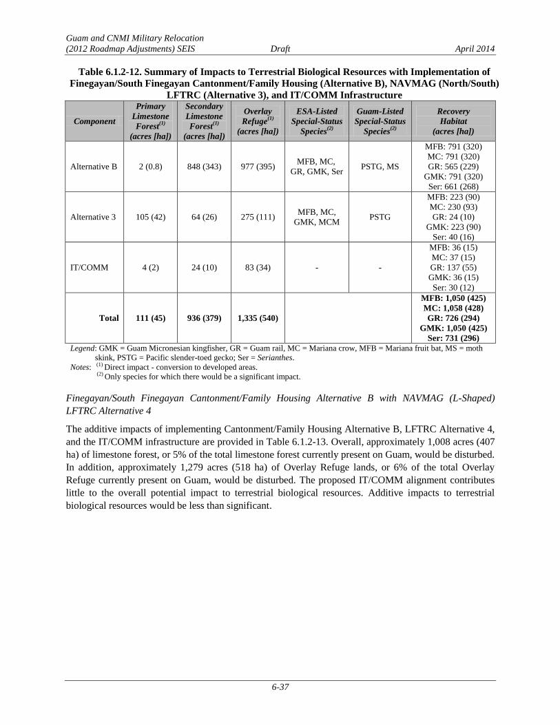
Guam and CNMI Military Relocation
(2012 Roadmap Adjustments) SEIS Draft April 2014
6-37
Table 6.1.2-12. Summary of Impacts to Terrestrial Biological Resources with Implementation of
Finegayan/South Finegayan Cantonment/Family Housing (Alternative B), NAVMAG (North/South)
LFTRC (Alternative 3), and IT/COMM Infrastructure
Component
Primary
Limestone
Forest(1)
(acres [ha])
Secondary
Limestone
Forest(1)
(acres [ha])
Overlay
Refuge(1)
(acres [ha])
ESA-Listed
Special-Status
Species(2)
Guam-Listed
Special-Status
Species(2)
Recovery
Habitat
(acres [ha])
Alternative B 2 (0.8) 848 (343) 977 (395) MFB, MC,
GR, GMK, Ser PSTG, MS
MFB: 791 (320)
MC: 791 (320)
GR: 565 (229)
GMK: 791 (320)
Ser: 661 (268)
Alternative 3 105 (42) 64 (26) 275 (111) MFB, MC,
GMK, MCM PSTG
MFB: 223 (90)
MC: 230 (93)
GR: 24 (10)
GMK: 223 (90)
Ser: 40 (16)
IT/COMM 4 (2) 24 (10) 83 (34) - -
MFB: 36 (15)
MC: 37 (15)
GR: 137 (55)
GMK: 36 (15)
Ser: 30 (12)
Total 111 (45) 936 (379) 1,335 (540)
MFB: 1,050 (425)
MC: 1,058 (428)
GR: 726 (294)
GMK: 1,050 (425)
Ser: 731 (296)
Legend: GMK = Guam Micronesian kingfisher, GR = Guam rail, MC = Mariana crow, MFB = Mariana fruit bat, MS = moth
skink, PSTG = Pacific slender-toed gecko; Ser = Serianthes.
Notes: (1) Direct impact - conversion to developed areas. (2) Only species for which there would be a significant impact.
Finegayan/South Finegayan Cantonment/Family Housing Alternative B with NAVMAG (L-Shaped)
LFTRC Alternative 4
The additive impacts of implementing Cantonment/Family Housing Alternative B, LFTRC Alternative 4,
and the IT/COMM infrastructure are provided in Table 6.1.2-13. Overall, approximately 1,008 acres (407
ha) of limestone forest, or 5% of the total limestone forest currently present on Guam, would be disturbed.
In addition, approximately 1,279 acres (518 ha) of Overlay Refuge lands, or 6% of the total Overlay
Refuge currently present on Guam, would be disturbed. The proposed IT/COMM alignment contributes
little to the overall potential impact to terrestrial biological resources. Additive impacts to terrestrial
biological resources would be less than significant.

Guam and CNMI Military Relocation
(2012 Roadmap Adjustments) SEIS Draft April 2014
6-38
Table 6.1.2-13. Summary of Impacts to Terrestrial Biological Resources with Implementation of
Finegayan/South Finegayan Cantonment/Family Housing (Alternative B), NAVMAG (L-Shaped)
LFTRC (Alternative 4), and IT/COMM Infrastructure
Component
Primary
Limestone
Forest(1)
(acres [ha])
Secondary
Limestone
Forest(1)
(acres [ha])
Overlay
Refuge(1)
(acres [ha])
ESA-Listed
Special-Status
Species(2)
Guam-Listed
Special-Status
Species(2)
Recovery
Habitat
(acres [ha])
Alternative B 2 (0.8) 848 (343) 977 (395) MFB, MC,
GR, GMK, Ser PSTG, MS
MFB: 791 (320)
MC: 791 (320)
GR: 565 (229)
GMK: 791 (320)
Ser: 661 (268)
Alternative 4 67 (27) 63 (26) 219 (88) MFB, MC, GMK PSTG
MFB: 161 (65)
MC: 166 (67)
GR: 50 (20)
GMK: 161 (65)
Ser: 19 (8)
IT/COMM 4 (2) 24 (10) 83 (34) - -
MFB: 36 (15)
MC: 37 (15)
GR: 137 (55)
GMK: 36 (15)
Ser: 30 (12)
Total 73 (29) 935 (378) 1,279 (518) - -
MFB: 988 (400)
MC: 994 (402)
GR: 752 (304)
GMK: 988 (400)
Ser: 710 (287)
Legend: GMK = Guam Micronesian kingfisher, GR = Guam rail, MC = Mariana crow, MFB = Mariana fruit
bat, MS = moth skink, PSTG = Pacific slender-toed gecko; Ser = Serianthes.
Notes: (1) Direct impact - conversion to developed areas.
(2) Only species for which there would be a significant impact.
Cultural Resources
Finegayan Cantonment/Family Housing Alternative A with any NAVMAG LFTRC Alternative
(Alternatives 2, 3, or 4)
Adverse effects to historic properties under NHPA and impacts to other cultural resources of cultural
importance resulting from the implementation of Alternative A and Alternatives 2, 3, or 4 would be equal
to the combined effects and impacts of each as discussed in Chapters 4 and 5. Additional effects and
impacts could also result from the construction of the IT/COMM links for these alternatives. Construction
for the IT/COMM lines for Alternative A and Alternatives 2, 3, or 4 would occur along Routes 1, 2A, 3,
3A, 4, 4A, 5, 9, 10, 15, and 17. In general, IT/COMM lines would follow existing roads; however,
additional lines would be constructed at AAFB and from AAFB to Finegayan. Approximately 45% of
these areas have been previously surveyed (Reinman 1967; Kurashina et al. 1987; Liston 1996; Lauter-
Reinman 1997; Hunter-Anderson and Moore 2003; Dixon et al. 2004, 2011a, 2011b, 2013a, 2013b;
Aaron et al. 2007; Grant et al. 2007; Welch 2010; Dixon and Walker 2011). As not all of the routes have
been surveyed, a literature review of previous surveys and sites located within the construction corridor
was undertaken and the likelihood of finding buried cultural resources within PDIA for the IT/COMM
lines corridor was assessed (Dixon et al. 2014). Within the PDIA for the IT/COMM lines, 19% of Route
1, 14% of Route 2A, 100% of Route 3, 73% of Route 3A, 5% of Route 4, 9% of Route 4A, 39% of Route
5, 79% of Route 9, none of Route 10, 36% of Route 15, and 1% of Route 17 have been surveyed.
Table 6.1.2-14 lists 15 known archaeological sites within the IT/COMM lines PDIA for Alternatives 2, 3,
and 4. Three of the sites, including an artifact scatter, a Japanese defensive complex, and portions of
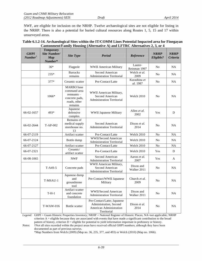
Guam and CNMI Military Relocation
(2012 Roadmap Adjustments) SEIS Draft April 2014
6-39
NWF, are eligible for inclusion on the NRHP. Twelve archaeological sites are not eligible for listing in
the NRHP. There is also a potential for buried cultural resources along Routes 1, 5, 15 and 17 within
unsurveyed areas.
Table 6.1.2-14. Archaeological Sites within the IT/COMM Lines Potential Impacted area for Finegayan
Cantonment/Family Housing (Alternative A) and LFTRC Alternatives 2, 3, or 4
GHPI
Number†
Temporary
Site Number/
Map
Number*
Site Type Period Reference NRHP
Eligible?
NRHP
Criteria
36* Flagpole WWII American Military Lauter-
Reinman 1997 No NA
235* Barracks
remains
Second American
Administration Territorial
Welch et al.
2009 No NA
377* Ceramic scatter Pre-Contact/Latte Kurashina et
al. 1987 No NA
1066*
MARBO base
command area
remnants –
concrete pads,
roads, other
remains
WWII American Military,
Second American
Administration Territorial
Welch 2010 No NA
66-02-1657 493*
Japanese
defensive
complex
WWII Japanese Military Allen et al.
2002 Yes D
66-02-2644 T-AP-002
Remains of
medical supply
storehouse no.
13
Second American
Administration Territorial
Dixon et al.
2014 No NA
66-07-2119 Artifact scatter Pre-Contact/Latte Welch 2010 No NA
66-07-2124 Bottle dump WWII/Second American
Administration Territorial Welch 2010 No NA
66-07-2127 Artifact scatter Pre-Contact/Latte Welch 2010 No NA
66-07-2321 Ceramic/
artifact scatter Pre-Contact/Latte Welch 2010 Yes D
66-08-1065 NWF Second American
Administration Territorial
Aaron et al.
2007 Yes A
T-A4S-5 Concrete pads
WWII American Military,
Second American
Administration Territorial
Dixon and
Walker 2011 No NA
T-MSAU-1
Japanese dump
and
groundstone
tool
Pre-Contact/WWII Japanese
Military
Church et al.
2009 No NA
T-H-1
Artifact scatter
and concrete
foundation
WWII/Second American
Administration Territorial
Dixon and
Walker 2011 No NA
T-WAW-016 Bottle scatter
Pre-Contact/Latte; Japanese
Administration, Second
American Administration
Territorial
Dixon et al.
2014 No NA
Legend: GHPI = Guam Historic Properties Inventory; NRHP = National Register of Historic Places; NA=not applicable; NRHP
criterion A = eligible because they are associated with events that have made a significant contribution to the broad
pattern of history, criterion D = eligible for potential to yield information important in prehistory or history.
Notes: †Not all sites recorded within the project areas have received official GHPI numbers, although they have been
documented as part of previous surveys.
*Map Numbers from Welch (2009) (Map no. 36, 235, 377, and 493) or Welch (2010) (Map no. 1066).

Guam and CNMI Military Relocation
(2012 Roadmap Adjustments) SEIS Draft April 2014
6-40
One structure eligible for listing in the NRHP, North Field, is also located within the potential impacted
area for Alternatives 2, 3, and 4. No TCPs have been identified in the potential impacted areas for the
IT/COMM lines.
The installation of IT/COMM links between Alternative A and the LFTRC Alternatives 2, 3, or 4 has the
potential to result in adverse effects from excavation and soil removal to four historic properties--three
NRHP-eligible archaeological sites (see Table 6.1.2-14) and one NRHP-eligible structure (North Field),
as well as undetermined effects to possible buried cultural resources in unsurveyed areas along Routes 1,
5, 15, an 17. Based on an examination of previous investigations and predictive modeling, there is a low
potential for NRHP-eligible sites in the remaining areas. No TCPs would be directly affected by the
construction of the IT/COMM links.
No direct or indirect adverse effects are anticipated to occur due to operation of the IT/COMM utilities as
these lines would be buried and there would be no change in use and no effects to the setting.
The 2011 PA, as discussed in Section 3.10.2, establishes a program alternative for complying with NHPA
Section 106 requirements. To the degree possible, impacts to historic properties and other resources of
cultural importance would be avoided during the planning process. Consultation under the 2011 PA will
address potential adverse effects and alternatives to avoid adverse effects. If avoidance is not possible,
potential minimization and mitigation measures may include data recovery and monitoring during
construction in areas with likelihood for buried cultural resources. However, final mitigation will be
determined after completion of the consultation process outlined in the PA. With the implementation of
these measures and processes as outlined in the 2011 PA, additive impacts associated with IT/COMM
would be reduced to a level below significance.
Finegayan/South Finegayan Cantonment/Family Housing Alternative B with any NAVMAG LFTRC
Alternative (Alternatives 2, 3, or 4)
Adverse effects to historic properties under NHPA and impacts to other cultural resources of cultural
importance resulting from the implementation of Alternative B and Alternatives 2, 3 or 4 would be equal
to the combined effects and impacts of each as discussed in Chapters 4 and 5. Additional effects and
impacts could also result from the construction of the IT/COMM links for these alternatives. The PDIA
for the IT/COMM lines for these site combinations would be similar to those described above for
Alternative A and Alternatives 2, 3, or 4. The installation of IT/COMM links between the Alternative B
and the LFTRC Alternatives 2, 3, or 4 has the potential to result in adverse effects from excavation and
soil removal to four historic properties--three NRHP-eligible archaeological sites (see Table 6.1.2-14) and
one NRHP-eligible structure (North Field), as well as undetermined effects to possible buried cultural
resources in unsurveyed areas along Routes 1, 5, 15, 17. Based on an examination of previous
investigations and predictive modelling, there is a low potential for NRHP-eligible sites in the remaining
area. No TCPs have been identified in the potential impacted areas for the IT/COMM lines.
No direct or indirect adverse effects due to operation of the IT/COMM utilities would occur as these lines
would be buried and there would be no change in use, and no effects to the setting.
The 2011 PA, as discussed in Section 3.10.2, establishes a program alternative for complying with NHPA
Section 106 requirements. To the degree possible, impacts to historic properties and other resources of
cultural importance would be avoided during the planning process. Consultation under the 2011 PA will
address potential adverse effects and alternatives to avoid adverse effects. If avoidance is not possible,
potential minimization and mitigation measures may include data recovery and monitoring during
construction in areas with likelihood for buried cultural resources. However, final mitigation will be

Guam and CNMI Military Relocation
(2012 Roadmap Adjustments) SEIS Draft April 2014
6-41
determined after completion of the consultation process outlined in the PA. With the implementation of
these measures and processes as outlined in the 2011 PA, additive impacts associated with IT/COMM
would be reduced to a level below significance.
Ground Transportation
Finegayan Cantonment/Family Housing Alternative A with any NAVMAG LFTRC Alternative
(Alternatives 2, 3, or 4)
Alternative A was modeled with Alternative 5 (Section 3.12.1). Pairing Alternative A with Alternative 2,
3, or 4 may result in a slight increase in vehicles (less than 5%) on roadway segments and at intersections
that comprise the most direct route between the Alternative A Main Gate and the Alternative 2, 3, or 4
gates, as well as a slight decrease in vehicles on roadway segments and at intersections that comprise the
most direct route between the modeled combination Alternative A Main Gate and the Alternative 5 gate.
This minimal incremental increase or decrease in traffic volumes would not adversely affect level of
service on roadways or at intersections along the route.
Roadway Segment Operations. Impacts and potential mitigation measures for all off-base (external)
roadway segments would be the same as those identified in Section 6.1.2.1 (see Table 6.1.2-6).
Significant impacts were identified on eight roadway segments. Potential mitigation measures would be
feasible at all locations and could reduce the identified significant impacts to less than significant levels.
The detailed results of the roadway segment analysis are provided in their entirety in Appendix F.
Intersection Operations. Impacts and potential mitigation measures for all intersections would be the
same as those identified in Section 6.1.2.1 (see Table 6.1.2-6). Significant impacts were identified at nine
intersections. Potential mitigation measures would be feasible at all locations and could reduce the
identified significant impacts to less than significant levels. The detailed results of the intersection
analysis are provided in its entirety in Appendix F.
Transit Conditions. Transit conditions under Alternative A with Alternative 2, 3, or 4, would be the same
as those described in Section 6.1.2.1 for Alternative A with Alternative 1.
Pedestrian and Bicycle Conditions. Pedestrian and bicycle conditions under Alternative A with Alternative 5
would be the same as those described in Section 6.1.2.1 for Alternative A with Alternative 1.
Finegayan/South Finegayan Cantonment/Family Housing Alternative B with any NAVMAG LFTRC
Alternative (Alternatives 2, 3, or 4)
Alternative B was modeled with Alternative 2 or 4 (see Section 3.12.1). Pairing Alternative B with
Alternative 3 may result in a slight increase in vehicles (less than 5%) on roadway segments and at
intersections along the most direct route between the Alternative B Main Gate and the Alternative 3 gate,
and a slight decrease in vehicles on roadway segments and at intersections along the most direct route
between the modeled combination of Alternative B Main Gate and the Alternative 2 or 4 gates (see Figure
6.1.2-1). This minimal incremental increase or decrease in traffic volumes would not adversely affect
level of service on roadways or at intersections along the route.
Roadway Segment Operations. Impacts and potential mitigation measures for all off-base (external)
roadway segments under Alternative B with Alternative 2, 3, or 4 would be the same as those identified in
Section 6.1.2.1 (see Table 6.1.2-7 and Table 6.1.2-12) for Alternative B with Alternative 1. Significant
impacts were identified on 10 roadway segments and potential mitigation measures were identified for 8
roadway segments. Potential mitigation measures have not been identified for these two locations. The
detailed results of the roadway segment analysis are provided in their entirety in Appendix F.

Guam and CNMI Military Relocation
(2012 Roadmap Adjustments) SEIS Draft April 2014
6-42
Intersection Operations. Impacts and potential mitigation measures for all study intersections under
Alternative B with Alternative 2, 3, or 4 would be the same as those identified in Section 6.1.2.1 (see
Table 6.1.2-7) for Alternative B with Alternative 1. Significant impacts were identified at 11 intersections
with potential mitigation measures identified for 9 intersections; potential mitigation measures have not
been identified for the remaining 2 intersections. The detailed results of the intersection analysis are
provided in their entirety in Appendix F.
Transit Conditions. Transit conditions under Alternative B with Alternative 2, 3, or 4 would be the same
as those described in Section 6.1.2.1 for Alternative A with Alternative 1.
Pedestrian and Bicycle Conditions. Pedestrian and bicycle conditions under Alternative B with Alternative 2,
3, or 4 would be the same as those described in Section 6.1.2.1 for Alternative A with Alternative 1.
Public Health and Safety
The potential for traffic incidents is the primary health and safety issue with potential for creating additive
impacts from implementing a specific cantonment/family housing alternative with a specific LFTRC
alternative. The driving distances between the Alternative A area and the proposed NAVMAG LFTRC
alternatives (Alternatives 2, 3, and 4) is approximately 22.3 miles (35.9 km) to Alternative 2, and 27.9
miles (44.9 km) to Alternatives 3 and 4. Vehicles would use Routes 1 and 3 to commute between the
Alternative A or B areas and Alternative 1, while Routes 3, 4, 10, and 16, as well as a new roadway in
Dandan, would be used to access Alternatives 3 and 4.
Five high-crash frequency intersections (intersections of Routes 1/3, Routes 1/14A, Routes 1/10A,
Routes 1/14, and Routes 1/30) are situated along the travel route between the Alternative A and
Alternative B area and Alternative 2. These intersections are primarily in the central portion of Guam in
the highest developed area of the island, within the communities of Hagåtña and Tamuning. Two high-
crash frequency intersections (intersection of Routes 1/3 and Routes 8/10/16) are situated along the travel
route between the Alternative A and Alternative B area and the Alternatives 3 and 4. In an effort to
improve vehicle safety at the intersection of Routes 8/10/16, traffic improvements were completed in
2012 that included the installation of a new traffic signal system that reduced congestion and channelized
traffic. The travel distance between the Alternative A or Alternative B area and the NAVMAG
alternatives is relatively long, and several high-frequency crash intersections are situated along the travel
routes (resulting in a higher potential for being involved in a traffic incident or to be delayed because of
traffic incidents). However, a less-than-significant additive impact on public health and safety is
anticipated to occur since the additional vehicles traveling between the main cantonment and LFTRC
would be an insignificant portion of total vehicles on these roadways.
Finegayan Cantonment/Family Housing Alternative A or B with NWF LFTRC Alternative 5 6.1.2.3
Air Quality
The combined air quality impacts would be the same as those described in Section 6.1.2.1. The combined
construction island-wide emissions impacts, summarized in Table 6.1.2-1, would be less than significant
as a result of this combined alternative.
Terrestrial Biological Resources
Finegayan Cantonment/Family Housing Alternative A with NWF LFTRC Alternative 5
The additive impacts of implementing Cantonment/Family Housing Alternative A, LFTRC Alternative 5,
and the IT/COMM infrastructure are provided in Table 6.1.2-15. Overall, approximately 1,249 acres (507

Guam and CNMI Military Relocation
(2012 Roadmap Adjustments) SEIS Draft April 2014
6-43
ha) of limestone forest, or 7% of the total limestone forest currently present on Guam, would be disturbed.
In addition, approximately 1,587 acres (642 ha) of Overlay Refuge lands, or 7% of the total Overlay
Refuge currently present on Guam, would be disturbed. The proposed IT/COMM alignment contributes
little to the overall potential impact to terrestrial biological resources. Additive impacts to terrestrial
biological resources would be less than significant.
Table 6.1.2-15. Summary of Impacts to Terrestrial Biological Resources with Implementation of
Finegayan Cantonment/Family Housing (Alternative A), NWF LFTRC (Alternative 5),
and IT/COMM Infrastructure
Component
Primary
Limestone
Forest(1)
(acres [ha])
Secondary
Limestone
Forest(1)
(acres [ha])
Overlay
Refuge(1)
(acres [ha])
ESA-Listed
Special-Status
Species(2)
Guam-Listed
Special-Status
Species(2)
Recovery
Habitat
(acres [ha])
Critical
Habitat
(acres [ha])
Alternative A 2 (0.7) 1,018 (412) 1,250 (506)
MFB, MC,
GR, GMK,
Ser
MS, PSTG
MFB: 977 (395)
MC: 978 (396)
GR: 458 (185)
GMK: 977 (395)
Ser: 661 (268)
NA
Alternative 5 90 (37) 111 (45) 254 (103) MFB, MC,
GMK, Ser -
MFB: 196 (79)
MC: 196 (79)
GR: 40 (16)
GMK: 196 (79)
Ser: 154 (62)
MFB, MC,
GMK: 12
(5)
IT/COMM 4 (2) 24 (10) 83 (34) - -
MFB: 36 (15)
MC: 37 (15)
GR: 137 (55)
GMK: 36 (15)
Ser: 30 (12)
NA
Total 96 (40) 1.153 (467) 1,587 (642) -
MFB: 1,209 (489)
MC: 1,211 (490)
GR: 635 (257)
GMK: 1,209 (489)
Ser: 845 (342)
-
Legend: GMK = Guam Micronesian kingfisher, GR = Guam rail, MC = Mariana crow, MFB = Mariana fruit bat, MS = moth skink,
PSTG = Pacific slender-toed gecko, Ser = Serianthes, NA = not applicable.
Notes: (1) Direct impact - conversion to developed areas.
(2) Only species for which there would be a significant impact.
Finegayan/South Finegayan Cantonment/Family Housing Alternative B with NWF LFTRC Alternative 5
The additive impacts of implementing Cantonment/Family Housing Alternative B, LFTRC Alternative 5,
and the IT/COMM infrastructure are provided in Table 6.1.2-16. Overall, approximately 1,079 acres (438
ha) of limestone forest, or 6% of the total limestone forest currently present on Guam, would be disturbed.
In addition, approximately 1,314 acres (532 ha) of Overlay Refuge lands, or 6% of the total Overlay
Refuge currently present on Guam, would be disturbed. The proposed IT/COMM alignment contributes
little to the overall potential impact to terrestrial biological resources. Additive impacts to terrestrial
biological resources would be less than significant.
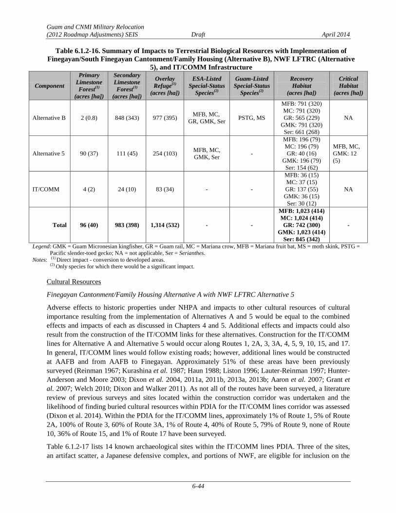
Guam and CNMI Military Relocation
(2012 Roadmap Adjustments) SEIS Draft April 2014
6-44
Table 6.1.2-16. Summary of Impacts to Terrestrial Biological Resources with Implementation of
Finegayan/South Finegayan Cantonment/Family Housing (Alternative B), NWF LFTRC (Alternative
5), and IT/COMM Infrastructure
Component
Primary
Limestone
Forest(1)
(acres [ha])
Secondary
Limestone
Forest(1)
(acres [ha])
Overlay
Refuge(1)
(acres [ha])
ESA-Listed
Special-Status
Species(2)
Guam-Listed
Special-Status
Species(2)
Recovery
Habitat
(acres [ha])
Critical
Habitat
(acres [ha])
Alternative B 2 (0.8) 848 (343) 977 (395) MFB, MC,
GR, GMK, Ser PSTG, MS
MFB: 791 (320)
MC: 791 (320)
GR: 565 (229)
GMK: 791 (320)
Ser: 661 (268)
NA
Alternative 5 90 (37) 111 (45) 254 (103) MFB, MC,
GMK, Ser -
MFB: 196 (79)
MC: 196 (79)
GR: 40 (16)
GMK: 196 (79)
Ser: 154 (62)
MFB, MC,
GMK: 12
(5)
IT/COMM 4 (2) 24 (10) 83 (34) - -
MFB: 36 (15)
MC: 37 (15)
GR: 137 (55)
GMK: 36 (15)
Ser: 30 (12)
NA
Total 96 (40) 983 (398) 1,314 (532) - -
MFB: 1,023 (414)
MC: 1,024 (414)
GR: 742 (300)
GMK: 1,023 (414)
Ser: 845 (342)
-
Legend: GMK = Guam Micronesian kingfisher, GR = Guam rail, MC = Mariana crow, MFB = Mariana fruit bat, MS = moth skink, PSTG =
Pacific slender-toed gecko; NA = not applicable, Ser = Serianthes.
Notes: (1) Direct impact - conversion to developed areas.
(2) Only species for which there would be a significant impact.
Cultural Resources
Finegayan Cantonment/Family Housing Alternative A with NWF LFTRC Alternative 5
Adverse effects to historic properties under NHPA and impacts to other cultural resources of cultural
importance resulting from the implementation of Alternatives A and 5 would be equal to the combined
effects and impacts of each as discussed in Chapters 4 and 5. Additional effects and impacts could also
result from the construction of the IT/COMM links for these alternatives. Construction for the IT/COMM
lines for Alternative A and Alternative 5 would occur along Routes 1, 2A, 3, 3A, 4, 5, 9, 10, 15, and 17.
In general, IT/COMM lines would follow existing roads; however, additional lines would be constructed
at AAFB and from AAFB to Finegayan. Approximately 51% of these areas have been previously
surveyed (Reinman 1967; Kurashina et al. 1987; Haun 1988; Liston 1996; Lauter-Reinman 1997; Hunter-
Anderson and Moore 2003; Dixon et al. 2004, 2011a, 2011b, 2013a, 2013b; Aaron et al. 2007; Grant et
al. 2007; Welch 2010; Dixon and Walker 2011). As not all of the routes have been surveyed, a literature
review of previous surveys and sites located within the construction corridor was undertaken and the
likelihood of finding buried cultural resources within PDIA for the IT/COMM lines corridor was assessed
(Dixon et al. 2014). Within the PDIA for the IT/COMM lines, approximately 1% of Route 1, 5% of Route
2A, 100% of Route 3, 60% of Route 3A, 1% of Route 4, 40% of Route 5, 79% of Route 9, none of Route
10, 36% of Route 15, and 1% of Route 17 have been surveyed.
Table 6.1.2-17 lists 14 known archaeological sites within the IT/COMM lines PDIA. Three of the sites,
an artifact scatter, a Japanese defensive complex, and portions of NWF, are eligible for inclusion on the

Guam and CNMI Military Relocation
(2012 Roadmap Adjustments) SEIS Draft April 2014
6-45
NRHP. Eleven archaeological sites are not eligible for listing in the NRHP. There is also a potential for
buried cultural resources along Routes 1, 5, 15, and 17 within unsurveyed areas.
Table 6.1.2-17. Archaeological Sites within the IT/COMM Utilities Potential Impacted area for
Finegayan Cantonment/Family Housing Alternative A with NWF LFTRC (Alternative) 5
GHPI
Number†
Temporary
Site
Number/Map
Number*
Site Type Period Reference NRHP
Eligible?
NRHP
Criteria
36* Flagpole WWII/Second American
Administration Territorial
Lauter-
Reinman 1997 No NA
377* Ceramic scatter Pre-Contact/Latte Kurashina et
al. 1987 No NA
1066*
MARBO base
command area
remnants –
concrete pads,
roads, other
remains
WWII American Military,
Second American
Administration Territorial
Welch 2010 No N/A
66-02-1657 493*
Japanese
defensive
complex
WWII Japanese Military Allen et al.
2002 Yes D
66-02-2644 T-AP-002
Remains of
medical supply
storehouse no. 13
Second American
Administration Territorial
Dixon et al.
2014 No NA
66-07-2119 Artifact scatter Pre-Contact/Latte Welch 2010 No NA
66-07-2124 Bottle dump WWII/Second American
Administration Territorial Welch 2010 No NA
66-07-2127 Artifact scatter Pre-Contact/Latte Welch 2010 No NA
66-07-2321 Ceramic/
artifact scatter Pre-Contact/Latte Welch 2010 Yes D
66-08-1065 NWF Second American
Administration Territorial
Aaron et al.
2007 Yes A
T-A4S-5 Concrete pads WWII/Second American
Administration Territorial
Dixon and
Walker 2011 No NA
T-MSAU-1
Japanese dump
and groundstone
tool
Pre-Contact/WWII
Japanese Military
Church et al.
2009 No NA
T-H20-1
Water catchment
with pump
generator & fuel
tank foundations
WWII/Second American
Administration Territorial
Dixon and
Walker 2011 No NA
T-WAW-016 Bottle scatter
Latte/Japanese
Administration/Second
American Administration
Territorial
Dixon et al.
2014 No N/A
Legend: GHPI = Guam Historic Properties Inventory; NRHP = National Register of Historic Places; NA=not applicable; NRHP
criterion A = eligible because they are associated with events that have made a significant contribution to the broad pattern
of history, criterion D = eligible for potential to yield information important in prehistory or history.
Notes: †Not all sites recorded within the project areas have received official GHPI numbers, although they have been documented
as part of previous surveys.
*From Welch (2009) (Map no. 36, 377, and 493) or Welch (2010) (map no. 1066).
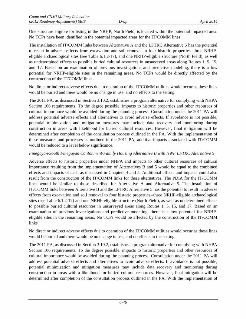
Guam and CNMI Military Relocation
(2012 Roadmap Adjustments) SEIS Draft April 2014
6-46
One structure eligible for listing in the NRHP, North Field, is located within the potential impacted area.
No TCPs have been identified in the potential impacted areas for the IT/COMM lines.
The installation of IT/COMM links between Alternative A and the LFTRC Alternative 5 has the potential
to result in adverse effects from excavation and soil removal to four historic properties--three NRHP-
eligible archaeological sites (see Table 6.1.2-17), and one NRHP-eligible structure (North Field), as well
as undetermined effects to possible buried cultural resources in unsurveyed areas along Routes 1, 5, 15,
and 17. Based on an examination of previous investigations and predictive modeling, there is a low
potential for NRHP-eligible sites in the remaining areas. No TCPs would be directly affected by the
construction of the IT/COMM links.
No direct or indirect adverse effects due to operation of the IT/COMM utilities would occur as these lines
would be buried and there would be no change in use, and no effects to the setting.
The 2011 PA, as discussed in Section 3.10.2, establishes a program alternative for complying with NHPA
Section 106 requirements. To the degree possible, impacts to historic properties and other resources of
cultural importance would be avoided during the planning process. Consultation under the 2011 PA will
address potential adverse effects and alternatives to avoid adverse effects. If avoidance is not possible,
potential minimization and mitigation measures may include data recovery and monitoring during
construction in areas with likelihood for buried cultural resources. However, final mitigation will be
determined after completion of the consultation process outlined in the PA. With the implementation of
these measures and processes as outlined in the 2011 PA, additive impacts associated with IT/COMM
would be reduced to a level below significance.
Finegayan/South Finegayan Cantonment/Family Housing Alternative B with NWF LFTRC Alternative 5
Adverse effects to historic properties under NHPA and impacts to other cultural resources of cultural
importance resulting from the implementation of Alternatives B and 5 would be equal to the combined
effects and impacts of each as discussed in Chapters 4 and 5. Additional effects and impacts could also
result from the construction of the IT/COMM links for these alternatives. The PDIA for the IT/COMM
lines would be similar to those described for Alternative A and Alternative 5. The installation of
IT/COMM links between Alternative B and the LFTRC Alternative 5 has the potential to result in adverse
effects from excavation and soil removal to four historic properties--three NRHP-eligible archaeological
sites (see Table 6.1.2-17) and one NRHP-eligible structure (North Field), as well as undetermined effects
to possible buried cultural resources in unsurveyed areas along Routes 1, 5, 15, and 17. Based on an
examination of previous investigations and predictive modeling, there is a low potential for NRHP-
eligible sites in the remaining areas. No TCPs would be affected by the construction of the IT/COMM
links.
No direct or indirect adverse effects due to operation of the IT/COMM utilities would occur as these lines
would be buried and there would be no change in use, and no effects to the setting.
The 2011 PA, as discussed in Section 3.10.2, establishes a program alternative for complying with NHPA
Section 106 requirements. To the degree possible, impacts to historic properties and other resources of
cultural importance would be avoided during the planning process. Consultation under the 2011 PA will
address potential adverse effects and alternatives to avoid adverse effects. If avoidance is not possible,
potential minimization and mitigation measures may include data recovery and monitoring during
construction in areas with a likelihood for buried cultural resources. However, final mitigation will be
determined after completion of the consultation process outlined in the PA. With the implementation of

Guam and CNMI Military Relocation
(2012 Roadmap Adjustments) SEIS Draft April 2014
6-47
these measures and processes as outlined in the 2011 PA, additive impacts associated with IT/COMM
would be reduced to a level below significance.
Ground Transportation
Finegayan Cantonment/Family Housing Alternative A with NWF LFTRC Alternative 5
Alternative A was modeled with Alternative 5 (Section 3.12.1).
Roadway Segment Operations. Impacts and potential mitigation measures for all off-base (external)
roadway segments under Alternative A with Alternative 5 would be the same as those identified in
Section 6.1.2.1 for Alternative A with Alternative 1. Potential mitigation measures were identified for all
impacted roadway segments, and if implemented, could reduce the impacts to less than significant levels.
Significant impacts were identified on eight roadway segments. The detailed results of the roadway
segment analysis are provided in their entirety in Appendix F.
Intersection Operations. Impacts and potential mitigation measures for all intersections under Alternative
A with Alternative 5 would be the same as those identified in Section 6.1.2.1 (see Table 6.1.2-6) for
Alternative A with Alternative 1. Potential mitigation measures were identified for all impacted
intersections, and if implemented, could reduce the impacts to less than significant levels. Significant
impacts were identified at nine intersections. The detailed results of the intersection analysis are provided
in its entirety in Appendix F.
Transit Conditions. Transit conditions under Alternative A with Alternative 5 would be the same as those
described in Section 6.1.2.1 for Alternative A with Alternative 1.
Pedestrian and Bicycle Conditions. Pedestrian and bicycle conditions under Alternative A with
Alternative 5 would be the same as those described in Section 6.1.2.1 for Alternative A with
Alternative 1.
Finegayan/South Finegayan Cantonment/Family Housing Alternative B with NWF LFTRC Alternative 5
Alternative B was modeled with Alternative 2 or 4 (Section 3.12.1). Pairing Alternative B with
Alternative 5 may result in a slight increase (less than 5%) in vehicles on roadway segments and at
intersections along the most direct route between the Alternative B Main Gate and the Alternative 5 gate,
and a slight decrease in vehicles on roadway segments and at intersections along the most direct route
between the modeled combination, Alternative B Main Gate and the Alternative 2 or 4 gate (see Figure
6.1.2-1). This minimal incremental increase or decrease in traffic volumes would not adversely affect
level of service on roadways or at intersections along the route.
Roadway Segment Operations. Impacts and potential mitigation measures for all off-base (external)
roadway segments would be the same as those identified in Section 6.1.2.1. Significant impacts were
identified on 10 roadway segments. Potential mitigation measures were identified for 8 roadway segments
and were not identified for 2 segments. The detailed results of the roadway segment analysis are provided
in their entirety in Appendix F.
Intersection Operations. Impacts and potential mitigation measures for all intersections would be the
same as those identified in Section 6.1.2.1 (see Table 6.1.2-7). Significant impacts were identified at 11
intersections. Potential mitigation measures were identified for 9 intersections and were not identified for
2 intersections. The detailed results of the intersection analysis are provided in its entirety in Appendix F.

Guam and CNMI Military Relocation
(2012 Roadmap Adjustments) SEIS Draft April 2014
6-48
Transit Conditions. Transit conditions under Alternative B with Alternative 5 would be the same as those
described in Section 6.1.2.1 for Alternative A with Alternative 1.
Pedestrian and Bicycle Conditions. Pedestrian and bicycle conditions under Alternative B with
Alternative 5 would be the same as those described in Section 6.1.2.1 for Alternative A with
Alternative 1.
Public Health and Safety
The potential for traffic incidents is the primary health and safety issue with potential for having additive
impacts from implementing a specific cantonment/family housing alternative with a specific LFTRC
alternative. The driving distance between the Alternative A or Alternative B area and the proposed NWF
LFTRC alternative (Alternative 5) is approximately 4.4 miles (7.1 km). Vehicles would use Routes 3 and
3A to commute between either of these cantonment/family housing areas and Alternative 5. No high-
crash frequency intersections are situated along this travel route. The travel distance between Alternative
A or B and Alternative 5 is relatively short, and no high-frequency crash intersections are situated along
this travel route. Therefore, no significant additive traffic impacts are anticipated.
AAFB Cantonment/Family Housing Alternative C with Route 15 LFTRC Alternative 1 6.1.2.4
Air Quality
The combined air quality impacts would be similar to those described in Section 6.1.2.1.
The combined construction island-wide emissions, summarized in Table 6.1.2-18, would be below the
significance criterion of 250 tpy for criteria pollutants resulting in less than significant as a result of this
combined alternative.
Table 6.1.2-18. AAFB Cantonment/Family Housing (Alternative C) with Route 15 LFTRC
(Alternative 1, 2, 3, 4, or 5) Annual Construction Emissions (2016-2022)
Construction
Year
Pollutant (tpy)
SO2 CO PM10 PM2.5 NOx VOC CO2
2016 neg neg neg neg neg neg neg
2017 0.1 3.5 0.3 0.3 5.3 0.7 724.7
2018 0.3 21.9 1.4 1.3 16.3 3.2 3176.9
2019 0.7 48.4 2.9 2.6 34.3 5.7 7625.4
2020 0.3 24.6 1.4 1.3 15.9 3.2 3540.8
2021 0.5 30.3 1.8 1.6 23.5 3.1 5219.8
2022 0.5 30.8 1.9 1.7 23.9 3.2 5309.9
Significance
Threshold 250 250 250 250 250 250 NA
Legend: CO = Carbon Monoxide; CO2 = Carbon Dioxide; NOx= Nitrogen Oxides; PM10 = Particulate Matter
(<10 microns); PM2.5= Particulate Matter (<2.5 microns); SO2 = Sulfur Dioxide; VOC = Volatile Organic
Compounds; neg = negligible; NA = not available.
Terrestrial Biological Resources
The additive impacts of implementing Cantonment/Family Housing Alternative C, LFTRC Alternative 1,
and the IT/COMM infrastructure are provided in Table 6.1.2-19. Overall, approximately 1,485 acres (601
ha) of limestone forest, or 8% of the total limestone forest currently present on Guam, would be disturbed.
In addition, approximately 1,002 acres (405 ha) of Overlay Refuge lands, or 5% of the total Overlay
Refuge currently present on Guam, would be disturbed. The proposed IT/COMM alignment contributes
little to the overall potential impact to terrestrial biological resources. Additive impacts to terrestrial

Guam and CNMI Military Relocation
(2012 Roadmap Adjustments) SEIS Draft April 2014
6-49
biological resources would be less than significant.
Table 6.1.2-19. Summary of Impacts to Terrestrial Biological Resources with Implementation of AAFB
Cantonment/Family Housing (Alternative C), Route 15 LFTRC (Alternative 1),
and IT/COMM Infrastructure
Component
Primary
Limestone
Forest(1)
(acres [ha])
Secondary
Limestone
Forest(1)
(acres [ha])
Overlay
Refuge(1)
(acres [ha])
ESA-Listed
Special-Status
Species(2)
Guam-Listed
Special-Status
Species(2)
Recovery
Habitat
(acres [ha])
Alternative C 138 (56) 1,066 (431) 924 (374)
MFB, MC,
GR, GMK,
Ser
-
MFB: 1,197 (484)
MC: 1,201 (486)
GR: 221 (89)
GMK: 1,197 (484)
Ser: 1,139 (461)
Alternative 1 65 (26) 190 (77) NA GR -
MFB: 81 (33)
MC: 81 (33)
GR: 283 (115)
GMK: 81 (33)
Ser: 67 (27)
IT/COMM 5 (2) 21 (8) 78 (32) - -
MFB: 30 (12)
MC: 29 (12)
GR: 140 (57)
GMK: 30 (12)
Ser: 22 (9)
Total 208 (84) 1,277 (517) 1,002 (405) - -
MFB: 1,308 (529)
MC: 1,311 (530)
GR: 644 (261)
GMK: 1,308 (529)
Ser: 1,228 (497)
Legend: GMK = Guam Micronesian kingfisher, GR = Guam rail, MC = Mariana crow, MFB = Mariana fruit bat,
Ser = Serianthes.
Notes: (1) Direct impact - conversion to developed areas.
(2) Only species for which there would be a significant impact.
Cultural Resources
Adverse effects to historic properties under NHPA and impacts to other cultural resources of cultural
importance resulting from the implementation of Alternatives C and 1 would be equal to the combined
effects and impacts of each as discussed in Chapters 4 and 5. Additional effects and impacts could also
result from the construction of the IT/COMM links for these alternatives. Construction for the IT/COMM
lines for Alternative C and Alternative 1 would occur along Routes 1, 2A, 3, 3A, 4, 5, 9, 10, 15, and 17.
In general, IT/COMM lines would follow existing roads; however, additional lines would be constructed
at AAFB and from AAFB to Finegayan. Approximately 47% of these areas have been previously
surveyed (Reinman 1967; Kurashina et al. 1987; Liston 1996; Lauter-Reinman 1997; Hunter-Anderson
and Moore 2003; Dixon et al. 2004, 2011b, 2013a, 2013b; Aaron et al. 2007; Grant et al. 2007; Welch
2010; Dixon and Walker 2011). As not all of the routes have been surveyed, a literature review of
previous surveys and sites located within the construction corridor was undertaken and the likelihood of
finding buried cultural resources within PDIA for the IT/COMM lines corridor was assessed (Dixon et al.
2014). Within the PDIA for the IT/COMM lines, approximately 1% of Route 1, 5% of Route 2A, 100%
of Route 3, 94% of Route 3A, 1% of Route 4, 39% of Route 5, 89% of Route 9, none of Route 10, 26% of
Route 15, and 1% of Route 17 have been surveyed.
Table 6.1.2-20 lists 13 known archaeological sites within the IT/COMM lines PDIA. Three of the sites,
including remnants of an encampment, a Latte Period artifact scatter, and portions NWF, are eligible to

Guam and CNMI Military Relocation
(2012 Roadmap Adjustments) SEIS Draft April 2014
6-50
the NRHP. Ten archaeological sites are not eligible for listing in the NRHP. There is also a potential for
buried cultural resources along Routes 1, 5, 15, and 17 within unsurveyed areas.
Table 6.1.2-20. Archaeological Sites within IT/COMM Lines Potential Impacted area for AAFB
Cantonment/Family Housing (Alternative C) and Route 15 LFTRC (Alternative 1)
GHPI
Number†
Temporary
Site
Number/Map
Number*
Site Type Period Reference NRHP
Eligible?
NRHP
Criteria
36* Flagpole WWII/Second American
Administration Territorial
Lauter-
Reinman 1997 No NA
377* Ceramic Scatter Pre-Contact/Latte Kurashina et al.
1987 No NA
1066*
MARBO base
command area
remnants –
concrete pads,
roads, other
remains
WWII American Military,
Second American
Administration Territorial
Welch 2010 No NA
66-02-2644 T-AP-002
Remains of
medical supply
storehouse no.
13
Second American
Administration Territorial
Dixon et al.
2014 No NA
66-07-2119 Artifact scatter Pre-Contact/Latte Welch 2010 No NA
66-07-2124 Bottle dump WWII, Second American
Administration Territorial Welch 2010 No NA
66-07-2127 Artifact scatter Pre-Contact/Latte Welch 2010 No NA
66-07-2128 Concrete pad WWII, Second American
Administration Territorial
Grant et al.
2007 No NA
66-08-1065 NWF Second American
Administration Territorial
Aaron et al.
2007 Yes A
66-08-2305 Encampment Second American
Administration Territorial Welch 2010 Yes D
66-08-2308 Artifact Scatter Pre-Contact/Latte Welch 2010 Yes D
T-A4S-5 Concrete pads WWII, Second American
Territorial
Dixon and
Walker 2011 No NA
T-WAW-016 Bottle scatter
Pre-Contact/Latte;
Japanese Administration,
Second American
Administration Territorial
Dixon et al.
2014 No N/A
Legend: GHPI = Guam Historic Properties Inventory; NRHP = National Register of Historic Places; NA=not applicable; NRHP
criterion A = eligible because they are associated with events that have made a significant contribution to the broad pattern
of history, criterion D = eligible for potential to yield information important in prehistory or history.
Notes: †Not all sites recorded within the project areas have received official GHPI numbers, although they have been documented
as part of previous surveys.
*From Welch 2009 (Map no. 36, 377) and Welch 2010 (Map no. 1066).
One structure eligible for listing in the NRHP, North Field, is located within the potential impacted area.
No TCPs have been identified in the potential impacted areas for the IT/COMM lines.
The installation of IT/COMM links between Alternative C and the LFTRC Alternative 1 has the potential
to result in adverse effects from excavation and soil removal to four historic properties--three NRHP-
eligible archaeological sites (see Table 6.1.2-20) and one NRHP-eligible structure (North Field), as well
as undetermined effects to possible buried cultural resources in unsurveyed areas along Routes 1, 5, 15,
17. Based on an examination of previous investigations and predictive modeling, there is a low potential

Guam and CNMI Military Relocation
(2012 Roadmap Adjustments) SEIS Draft April 2014
6-51
for NRHP-eligible sites in the remaining areas. No TCPs would be affected by the construction of the
IT/COMM links.
No direct or indirect adverse effects due to operation of the IT/COMM utilities would occur as these lines
would be buried and there would be no change in use, and no effects to the setting.
The 2011 PA, as discussed in Section 3.10.2, establishes a program alternative for complying with NHPA
Section 106 requirements. To the degree possible, impacts to historic properties and other resources of
cultural importance would be avoided during the planning process. Consultation under the 2011 PA will
address potential adverse effects and alternatives to avoid adverse effects. If avoidance is not possible,
potential minimization and mitigation measures may include data recovery and monitoring during
construction in areas with likelihood for buried cultural resources. However, final mitigation will be
determined after completion of the consultation process outlined in the PA. With the implementation of
these measures and processes as outlined in the 2011 PA, additive impacts associated with IT/COMM
would be reduced to a level below significance.
Ground Transportation
The travel demand modeling methodology for the combination of alternatives was defined and directed
by the DoD and the FHWA to provide detailed off-base (external) roadway and intersection analysis for
one representative pairing (the modeled combination) for a cantonment/family housing alternative and
LFTRC site alternative. The modeled combination for Alternative C involved a pairing with Alternative 2
or 4 (see Section 3.12.1). Modeling results for this scenario indicate that weekday a.m. peak hour vehicle
traffic related to the proposed action is generated solely by operations at the cantonment/family housing
area. LFTRC-related traffic would occur prior to the weekday a.m. peak hour (8:00 a.m.) and may
coincide with the weekday p.m. peak hour (4:30 p.m. to 5:30 p.m.) (see Section 5.1.12).
Operations of the LFTRC would increase traffic on the off-base (external) roadway segments and intersections
that comprise the most direct route between the main cantonment gate and the LFTRC gates by approximately
38 vehicles (measured in passenger car equivalents) (see Table 5.1.12-2). LFTRC-related traffic represents an
insubstantial amount of traffic (less than 5%) along the route. This minimal incremental increase in traffic
volumes would not adversely affect level of service on roadways or at intersections along the route. The
relative contribution from LFTRC traffic to the off-base (external) roadway segment and intersection impacts
of each cantonment/family housing alternative would be minimal and would not vary appreciably with any
LFTRC alternative (Alternative 1, 2, 3, 4, and 5). Therefore, the impacts to the off-base (external) roadway
segments and intersections would be essentially the same for Alternative C with Alternative 1, Alternative C
with Alternative 2, 3, or 4, and Alternative C with Alternative 5. A qualitative discussion of the potential
effects of LFTRC-related traffic is provided for each combination.
Pairing Alternative C with Alternative 1 may result in a slight increase in vehicles (less than 5%) on
roadway segments and at intersections that comprise the most direct route between the Alternative C
Main Gate and the Alternative 1 gate, and a slight decrease in vehicles compared to the modeled
combination, Alternative C Main Gate and the Alternative 2 or 4 gates (Figure 6.1.2-3). This minimal
incremental increase or decrease in traffic volumes would not adversely affect level of service on
roadways or at intersections along the route.

LFTRC NWFAlternative (Alt. 5)
LFTRC Route 15Alternative (Alt. 1)
LFTRC NAVMAG East/WestAlternative (Alt. 2)
LFTRC NAVMAG L-ShapedAlternative (Alt. 4)
LFTRC NAVMAG North/SouthAlternative (Alt. 3)
NWF
FINEGAYAN
SOUTHFINEGAYAN
AAFB Cantonment/FamilyHousing Alternative
(Alt. C)
MT SANTAROSA
AAFB SOUTHBARRIGADA
NAVMAG
NAVALBASE GUAM
SASA VALLEYTANK FARM
NAVALHOSPITAL
DededoYigo
Tamuning
HAGATNA
Inarajan
Umatac
Agat
APRA HEIGHTS
AAFB to NAVMAG East/Westand L-Shaped AlternativesModeled Combination
Figure 6.1.2-3Travel Routes from AAFB Cantonment/Family
Housing (Alternative C) to the LFTRC Alternatives
LegendTravel Routes from AAFB (Alternative C) to the LFTRC Alternatives
NWF (6.5 mi/10.5 km)Route 15 (5.5 mi/8.9 km)NAVMAG East-West (30.2 mi/48.6 km)NAVMAG L-Shaped (30.2 mi/48.6 km)NAVMAG North-South (24.6 mi/39.6 km)HighwaysAirfieldsAAFB Cantonment/Family Housing AlternativeLFTRC AlternativesDoD Properties
P h i l i p p i n eS e a
P a c i f i cO c e a n
Guam
Area of Detail
1 " = 237 Miles
0 2 4Miles
0 2 4Kilometers
Source: NAVFAC Pacific 2013
P h i l i p p i n eS e a
P a c i f i cO c e a n
6-52
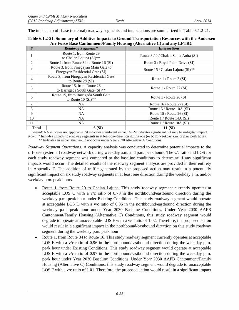
Guam and CNMI Military Relocation
(2012 Roadmap Adjustments) SEIS Draft April 2014
6-53
The impacts to off-base (external) roadway segments and intersections are summarized in Table 6.1.2-21.
Table 6.1.2-21. Summary of Additive Impacts to Ground Transportation Resources with the Andersen
Air Force Base Cantonment/Family Housing (Alternative C) and any LFTRC # Roadway Segments* Intersections
1 Route 1, from Route 29
to Chalan Lajuna (SI)** Route 3 / 9 / Chalan Santa Anita (SI)
2 Route 1, from Route 34 to Route 16 (SI) Route 3 / Royal Palm Drive (SI)
3 Route 3, from Finegayan Main Gate to
Finegayan Residential Gate (SI) Route 15 / Chalan Lajuna (SI)**
4 Route 3, from Finegayan Residential Gate
to Route 28 (SI) Route 1 / Route 3 (SI)
5 Route 15, from Route 26
to Barrigada South Gate (SI)** Route 1 / Route 27 (SI)
6 Route 15, from Barrigada South Gate
to Route 10 (SI)** Route 1 / Route 26 (SI)
7 NA Route 16 / Route 27 (SI)
8 NA Route 16 / Route 10A (SI)
9 NA Route 15 / Route 26 (SI)
10 NA Route 1 / Route 14A (SI)
11 NA Route 1 / Route 10A (SI)
Total 6 (SI) 11 (SI) Legend: NA indicates not applicable. SI indicates significant impact. SI-M indicates significant but may be mitigated impact.
Note: * Includes impacts to roadway segments in at least one direction during one (or both) weekday a.m. or p.m. peak hours.
** Indicates an impact that would not occur under Year 2030 Alternative A Conditions.
Roadway Segment Operations. A capacity analysis was conducted to determine potential impacts to the
off-base (external) roadway network during weekday a.m. and p.m. peak hours. The v/c ratio and LOS for
each study roadway segment was compared to the baseline conditions to determine if any significant
impacts would occur. The detailed results of the roadway segment analysis are provided in their entirety
in Appendix F. The addition of traffic generated by the proposed action may result in a potentially
significant impact on six study roadway segments in at least one direction during the weekday a.m. and/or
weekday p.m. peak hours.
Route 1, from Route 29 to Chalan Lajuna. This study roadway segment currently operates at
acceptable LOS C with a v/c ratio of 0.78 in the northbound/eastbound direction during the
weekday p.m. peak hour under Existing Conditions. This study roadway segment would operate
at acceptable LOS D with a v/c ratio of 0.86 in the northbound/eastbound direction during the
weekday p.m. peak hour under Year 2030 Baseline Conditions. Under Year 2030 AAFB
Cantonment/Family Housing (Alternative C) Conditions, this study roadway segment would
degrade to operate at unacceptable LOS F with a v/c ratio of 1.02. Therefore, the proposed action
would result in a significant impact in the northbound/eastbound direction on this study roadway
segment during the weekday p.m. peak hour.
Route 1, from Route 34 to Route 16. This study roadway segment currently operates at acceptable
LOS E with a v/c ratio of 0.96 in the northbound/eastbound direction during the weekday p.m.
peak hour under Existing Conditions. This study roadway segment would operate at acceptable
LOS E with a v/c ratio of 0.97 in the northbound/eastbound direction during the weekday p.m.
peak hour under Year 2030 Baseline Conditions. Under Year 2030 AAFB Cantonment/Family
Housing (Alternative C) Conditions, this study roadway segment would degrade to unacceptable
LOS F with a v/c ratio of 1.01. Therefore, the proposed action would result in a significant impact
Guam and CNMI Military Relocation
(2012 Roadmap Adjustments) SEIS Draft April 2014
6-54
in the northbound/eastbound direction on this study roadway segment during the weekday p.m.
peak hour.
Route 3, from Finegayan Main Gate to Finegayan Residential Gate. This study roadway segment
currently operates at unacceptable LOS F with a v/c ratio of 1.09 in the southbound/westbound
direction during the weekday p.m. peak hour under Existing Conditions. This study roadway
segment would continue to operate at unacceptable LOS F with a v/c ratio of 1.24 in the
southbound/westbound direction during the weekday a.m. peak hour under Year 2030 Baseline
Conditions. Under Year 2030 AAFB Cantonment/Family Housing (Alternative C) Conditions,
this study roadway segment would continue to operate at unacceptable LOS F with a v/c ratio of
1.33. The proposed action would increase traffic on this study roadway segment by
approximately 70 vehicles during the weekday p.m. peak hour. This 7.1% increase in traffic
exceeds the 5.0% threshold of significance. Therefore, the proposed action would result in a
significant impact on this study roadway segment in the southbound/westbound direction during
the weekday a.m. peak hour.
Route 3, from Finegayan Residential Gate to Route 28. This study roadway segment currently
operates at unacceptable LOS F with a v/c ratio of 1.23 in the southbound/westbound direction
during the weekday a.m. peak hour under Existing Conditions. This study roadway segment
would continue to operate at LOS F with a v/c ratio of 1.36 in the southbound/westbound
direction during the weekday a.m. peak hour under Year 2030 Baseline Conditions. Under Year
2030 AAFB Cantonment/Family Housing (Alternative C) Conditions, this study roadway
segment would continue to operate at unacceptable LOS F with a v/c ratio of 1.45. The proposed
action would increase the traffic on this study roadway segment by approximately 67 vehicles
during the weekday a.m. peak hour. This 6.3% increase in traffic is greater than the 5.0%
threshold of significance. During the weekday p.m. peak hour this study roadway segment
currently operates at acceptable LOS D with a v/c ratio of 0.81 in the northbound/eastbound
direction. This study roadway segment would operate at acceptable LOS E in the
northbound/eastbound direction during the weekday p.m. peak hour under Year 2030 Baseline
Conditions. Under Year 2030 AAFB Cantonment/Family Housing (Alternative C) Conditions,
this study roadway segment would degrade to unacceptable LOS F with a v/c ratio of 1.04.
Therefore, the proposed action would result in a significant impact on this study roadway
segment in the southbound/westbound directions during the weekday a.m. peak hour and in the
northbound/eastbound direction during the weekday p.m. peak hour.
Route 15, from Route 26 to Barrigada South Gate. This study roadway segment currently
operates at unacceptable LOS F with a v/c ratio of 1.05 in the northbound/eastbound direction
during the weekday p.m. peak hour under Existing Conditions. This study roadway segment
would continue to operate at unacceptable LOS F with a v/c ratio of 1.06 in the
northbound/eastbound direction during the weekday p.m. peak hour under Year 2030 Baseline
Conditions. Under Year 2030 AAFB Cantonment/Family Housing (Alternative C) Conditions,
this study roadway segment would continue to operate at unacceptable LOS F with a v/c ratio of
118. The proposed action would increase traffic on this study roadway segment by approximately
90 vehicles during the weekday p.m. peak hour. This 10.6% increase in traffic exceeds the 5.0%
threshold of significance. Therefore, the proposed action would result in a significant impact in
the northbound/eastbound direction on this study roadway segment during the weekday a.m. peak
hour.
Route 15, from Barrigada South Gate to Route 10. This study roadway segment currently
operates at acceptable LOS D with a v/c ratio of 0.90 in the northbound/eastbound direction
Guam and CNMI Military Relocation
(2012 Roadmap Adjustments) SEIS Draft April 2014
6-55
during the weekday p.m. peak hour under Existing Conditions. This study roadway segment
would operate at unacceptable LOS F with a v/c ratio of 1.02 in the northbound/eastbound
direction during the weekday p.m. peak hour under Year 2030 Baseline Conditions. Under Year
2030 AAFB Cantonment/Family Housing (Alternative C) Conditions, this study roadway
segment would continue to operate at unacceptable LOS F with a v/c ratio of 1.14. The proposed
action would increase traffic on this study roadway segment by approximately 88 vehicles during
the weekday a.m. peak hour. This 10.3% increase in traffic exceeds the 5.0% threshold of
significance. Therefore, the proposed action would result in a significant impact in the
northbound/eastbound direction on this study roadway segment during the weekday a.m. peak
hour.
Significant impacts were identified for all impacted roadway segments. Potential mitigation measures for
the impacted roadway segments would be similar in scope and scale to those identified in Section 6.1.2.1.
However, the exact details of the improvements would require further evaluations and technical studies to
determine their feasibility. The final list of implementable mitigation measures will be dependent on the
selected alternative or combination of alternatives, and based on project-level technical studies to be
conducted after the alternative or combination of alternatives is selected. FHWA will conduct all NEPA
documentation efforts and any associated resource consultations as specific mitigation measures are
proposed.
Intersection Operations. Intersection analysis was conducted to determine potential impacts to the off-
base (external) intersections during weekday a.m. and p.m. peak hours. The LOS for each study
intersection is compared to the baseline conditions to determine if any significant impacts would occur.
An impact summary is provided in Table 6.1.2-21. The detailed results of the intersection analysis are
provided in their entirety in Appendix F.
The addition of traffic generated by the proposed action would potentially result in a significant impact at
11 study intersections during the weekday a.m. and/or weekday p.m. peak hours.
Route 3 / 9 / Chalan Santa Anita. This two-way stop-controlled study intersection currently
operates at acceptable LOS C with 21.9 seconds of delay and would operate at acceptable LOS E
with 37.7 seconds of delay during the weekday a.m. peak hour under Existing Conditions and
Year 2030 Baseline Conditions, respectively. Under Year 2030 AAFB Cantonment/Family
Housing (Alternative C) Conditions, this study intersection would degrade to unacceptable LOS F
with 134.6 seconds of delay. Therefore, the proposed action would result in a significant impact
on this study intersection during the weekday a.m. peak hour.
Route 3 / Royal Palm Drive. This two-way stop-controlled study intersection currently operates at
acceptable LOS C with 16.3 seconds of delay and would operate at acceptable LOS E with 36.4
seconds of delay during the weekday a.m. peak hour under Existing Conditions and Year 2030
Baseline Conditions, respectively. Under Year 2030 AAFB Cantonment/Family Housing
(Alternative C) Conditions, this study intersection would degrade to unacceptable LOS F with
50.6 seconds of delay. Therefore, the proposed action would result in a significant impact on this
study intersection during the weekday a.m. peak hour.
Route 15 / Chalan Lajuna. This two-way stop-controlled study intersection currently operates at
acceptable LOS D with 30.7 seconds of delay and LOS C with 23.9 seconds of delay during the
weekday a.m. and p.m. peak hours, respectively, under Existing Conditions. This intersection
would operate at unacceptable LOS F with 75.8 and 82.6 seconds of delay during the weekday
a.m. and p.m. peak hours, respectively, under Year 2030 Baseline Conditions. Under Year 2030

Guam and CNMI Military Relocation
(2012 Roadmap Adjustments) SEIS Draft April 2014
6-56
AAFB Cantonment/Family Housing (Alternative C) Conditions, this study intersection would
continue to operate at unacceptable LOS F with 119.9 and 166.3 seconds of delay during the
weekday a.m. and p.m. peak hours, respectively. The proposed action would add more than 50
vehicles to this poorly performing intersection. Therefore, the proposed action would result in a
significant impact on this study intersection during the weekday a.m. and p.m. peak hours.
Route 1 / Route 3. This signalized study intersection currently operates at LOS F and would
continue to operate at unacceptable LOS F with greater than 180.0 seconds of delay during the
weekday a.m. peak hour under Existing Conditions and Year 2030 Baseline Conditions,
respectively. Under Year 2030 AAFB Cantonment/Family Housing (Alternative C) Conditions,
this study intersection would continue to operate at unacceptable LOS F with greater than 180.0
seconds of delay and the proposed action would add more than 50 vehicles to this poorly
performing intersection. Therefore, the proposed action would result in a significant impact on
this study intersection during the weekday a.m. peak hour.
Route 1 / Route 27. This signalized study intersection currently operates at acceptable LOS E
with 70.3 seconds of delay and would operate at unacceptable LOS F with 118.3 seconds of delay
during the weekday a.m. peak hour under Existing Conditions and Year 2030 Baseline
Conditions, respectively. Under Year 2030 AAFB Cantonment/Family Housing (Alternative C)
Conditions, this study intersection would continue to operate at unacceptable LOS F with 123.6
seconds of delay. The proposed action would add more than 50 vehicles to this poorly performing
intersection. Therefore, the proposed action would result in a significant impact on this study
intersection during the weekday a.m. peak hour.
Route 1 / Route 26. This signalized study intersection currently operates at acceptable LOS C
with 27.9 seconds of delay and would operate at unacceptable LOS F with 87.6 seconds of delay
during the weekday p.m. peak hour under Existing Conditions and Year 2030 Baseline
Conditions, respectively. Under Year 2030 AAFB Cantonment/Family Housing (Alternative C)
Conditions, this study intersection would continue to operate at unacceptable LOS F with 95.7
seconds of delay. The proposed action would add more than 50 vehicles to this poorly performing
intersection. Therefore, the proposed action would result in a significant impact on this study
intersection during the weekday p.m. peak hour.
Route 16 / Route 27. This signalized study intersection currently operates at acceptable LOS D
with 50.1 seconds of delay and acceptable LOS E with 71.2 seconds of delay during the weekday
a.m. and p.m. peak hours, respectively, under Existing Conditions. This signalized study
intersection would operate at unacceptable LOS F with greater than 180.0 seconds of delay and
154.7 seconds of delay during the weekday a.m. and p.m. peak hours, respectively under Year
2030 Baseline Conditions. Under Year 2030 AAFB Cantonment/Family Housing (Alternative C)
Conditions, this study intersection would continue to operate at unacceptable LOS F with greater
than 180.0 seconds of delay and 161.9 seconds of delay during the weekday a.m. and p.m. peak
hours, respectively. The proposed action would add more than 50 vehicles to this poorly
performing intersection. Therefore, the proposed action would result in a significant impact on
this study intersection during the weekday a.m. and p.m. peak hours.
Route 16 / Route 10A. This signalized study intersection currently operates at unacceptable LOS
F and would continue to operate at unacceptable LOS F with greater than 180.0 seconds of delay
during the weekday a.m. peak hour under Existing Conditions and Year 2030 Baseline
Conditions, respectively. Under Year 2030 AAFB Cantonment/Family Housing (Alternative C)
Conditions, this study intersection would continue to operate at unacceptable LOS F with greater
than 180.0 seconds of delay. The proposed action would add more than 50 vehicles to this poorly
Guam and CNMI Military Relocation
(2012 Roadmap Adjustments) SEIS Draft April 2014
6-57
performing intersection. Therefore, the proposed action would result in a significant impact on
this study intersection during the weekday a.m. peak hour.
Route 15 / Route 26. This two-way stop-controlled study intersection currently operates at
unacceptable LOS F with 62.1 seconds of delay and 147.3 seconds of delay during the weekday
a.m. and p.m. peak hours, respectively, under Existing Conditions. This intersection would
continue to operate at unacceptable LOS F with greater than 145.2 seconds of delay and greater
than 180.0 seconds of delay during the weekday a.m. and p.m. peak hours, respectively under
Year 2030 Baseline Conditions. Under Year 2030 AAFB Cantonment/Family Housing
(Alternative C) Conditions, this study intersection would continue to operate at unacceptable LOS
F with greater than 180.0 seconds of delay during the weekday a.m. and p.m. peak hours. The
proposed action would add more than 50 vehicles to this poorly performing intersection.
Therefore, the proposed action would result in a significant impact on this study intersection
during the weekday a.m. and p.m. peak hours.
Route 1 / Route 14A. This signalized study intersection currently operates at unacceptable LOS F
with 156.1 seconds of delay during the weekday p.m. peak hour under Existing Conditions. This
study intersection would continue to operate at unacceptable LOS F with greater than 180.0
seconds of delay during the weekday p.m. peak hour under Year 2030 Baseline Conditions.
Under Year 2030 AAFB Cantonment/Family Housing (Alternative C) Conditions, this study
intersection would continue to operate at unacceptable LOS F with greater than 180.0 seconds of
delay. The proposed action would add more than 50 vehicles to this poorly performing
intersection. Therefore, the proposed action would result in a significant impact on this study
intersection during the weekday a.m. peak hour.
Route 1 / Route 10A. This signalized study intersection currently operates at acceptable LOS E
with 62.6 seconds of delay and would operate at unacceptable LOS F with 139.3 seconds of delay
during the weekday p.m. peak hour under Existing Conditions and Year 2030 Baseline
Conditions, respectively. Under Year 2030 AAFB Cantonment/Family Housing (Alternative C)
Conditions, this study intersection would continue to operate at unacceptable LOS F with 141.6
seconds of delay. The proposed action would add more than 50 vehicles to this poorly performing
intersection. Therefore, the proposed action would result in a significant impact on this study
intersection during the weekday p.m. peak hour.
Although significant impacts would occur at all intersections, potential mitigation measures have not been
identified. Potential mitigation measures for the impacted intersections would be similar in scope and
scale to those identified in Section 6.1.2.1. However, the exact details of the improvements would require
further evaluations and technical studies to determine their feasibility. The final list of implementable
mitigation measures will be dependent on the selected alternative or combination of alternatives and
based on project-level technical studies, to be conducted after the alternative or combination of
alternatives is selected. FHWA will conduct all NEPA documentation efforts and any associated resource
consultations as specific mitigation measures are proposed.
Transit Conditions. Transit conditions under Alternative C with Alternative 1 would be similar to those
described in Section 6.1.2.1 for Alternative A with Alternative 1.
Pedestrian and Bicycle Conditions. Pedestrian and bicycle conditions under Alternative C with
Alternative 1 would be similar to those described in Section 6.1.2.1 for Alternative A with Alternative 1.
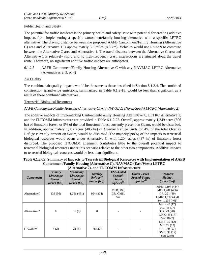
Guam and CNMI Military Relocation
(2012 Roadmap Adjustments) SEIS Draft April 2014
6-58
Public Health and Safety
The potential for traffic incidents is the primary health and safety issue with potential for creating additive
impacts from implementing a specific cantonment/family housing alternative with a specific LFTRC
alternative. The driving distance between the proposed AAFB Cantonment/Family Housing (Alternative
C) area and Alternative 1 is approximately 5.5 miles (8.8 km). Vehicles would use Route 9 to commute
between the Alternative C area and Alternative 1. The travel distance between the Alternative C area and
Alternative 1 is relatively short, and no high-frequency crash intersections are situated along the travel
route. Therefore, no significant additive traffic impacts are anticipated.
AAFB Cantonment/Family Housing Alternative C with any NAVMAG LFTRC Alternative 6.1.2.5
(Alternatives 2, 3, or 4)
Air Quality
The combined air quality impacts would be the same as those described in Section 6.1.2.4. The combined
construction island-wide emissions, summarized in Table 6.1.2-18, would be less than significant as a
result of these combined alternatives.
Terrestrial Biological Resources
AAFB Cantonment/Family Housing (Alternative C) with NAVMAG (North/South) LFTRC (Alternative 2)
The additive impacts of implementing Cantonment/Family Housing Alternative C, LFTRC Alternative 2,
and the IT/COMM infrastructure are provided in Table 6.1.2-22. Overall, approximately 1,249 acres (506
ha) of limestone forest, or 9% of the total limestone forest currently present on Guam, would be disturbed.
In addition, approximately 1,002 acres (405 ha) of Overlay Refuge lands, or 4% of the total Overlay
Refuge currently present on Guam, would be disturbed. The majority (98%) of the impacts to terrestrial
biological resources would occur under Alternative C, with 1,204 acres (487 ha) of limestone forest
disturbed. The proposed IT/COMM alignment contributes little to the overall potential impact to
terrestrial biological resources under this scenario relative to the other two components. Additive impacts
to terrestrial biological resources would be less than significant.
Table 6.1.2-22. Summary of Impacts to Terrestrial Biological Resources with Implementation of AAFB
Cantonment/Family Housing (Alternative C), NAVMAG (East/West) LFTRC
(Alternative 2), and IT/COMM Infrastructure
Component
Primary
Limestone
Forest(1)
(acres [ha])
Secondary
Limestone
Forest(1)
(acres [ha])
Overlay
Refuge(1)
(acres [ha])
ESA-Listed
Special-
Status
Species(2)
Guam-Listed
Special-Status
Species(2)
Recovery
Habitat
(acres [ha])
Alternative C 138 (56) 1,066 (431) 924 (374)
MFB, MC,
GR, GMK,
Ser
-
MFB: 1,197 (484)
MC: 1,201 (486)
GR: 221 (89)
GMK: 1,197 (484)
Ser: 1,139 (461)
Alternative 2 0 19 (8) 0 - -
MFB: 43 (17)
MC: 43 (17)
GR: 49 (20)
GMK: 43 (17)
Ser: 18 (7)
IT/COMM 5 (2) 21 (8) 78 (32) - -
MFB: 30 (12)
MC: 29 (12)
GR: 140 (57)
GMK: 30 (12)
Ser: 22 (9)

Guam and CNMI Military Relocation
(2012 Roadmap Adjustments) SEIS Draft April 2014
6-59
Component
Primary
Limestone
Forest(1)
(acres [ha])
Secondary
Limestone
Forest(1)
(acres [ha])
Overlay
Refuge(1)
(acres [ha])
ESA-Listed
Special-
Status
Species(2)
Guam-Listed
Special-Status
Species(2)
Recovery
Habitat
(acres [ha])
Total 143 (58) 1,106 (448) 1,002 (405) - -
MFB: 1,270 (514)
MC: 1,273 (515)
GR: 410 (166)
GMK: 1,270 (514)
Ser: 1,179 (477)
Legend: GMK = Guam Micronesian kingfisher, GR = Guam rail, MC = Mariana crow, MFB = Mariana fruit bat, Ser = Serianthes.
Notes: (1)
Direct impact - conversion to developed areas.
(2)
Only species for which there would be a significant impact.
AAFB Cantonment/Family Housing Alternative C with NAVMAG (North/South) LFTRC Alternative 3
The additive impacts of implementing Cantonment/Family Housing Alternative C, LFTRC Alternative 3,
and the IT/COMM infrastructure are provided in Table 6.1.2-23. Overall, approximately 1,399 acres (566
ha) of limestone forest, or 7% of the total limestone forest currently present on Guam, would be disturbed.
In addition, approximately 1,277 acres (517 ha) of Overlay Refuge lands, or 6% of the total Overlay
Refuge currently present on Guam, would be disturbed. The majority of the impacts to terrestrial
biological resources would occur under Alternative C, with 1,204 acres (487 ha) of limestone forest
disturbed. The proposed IT/COMM alignment contributes little to the overall potential impact to
terrestrial biological resources relative to the other components under this scenario. Additive impacts to
terrestrial biological resources would be less than significant.
Table 6.1.2-23. Summary of Impacts to Terrestrial Biological Resources with Implementation of AAFB
Cantonment/Family Housing (Alternative C), NAVMAG (North/South) LFTRC (Alternative 3), and
IT/COMM Infrastructure
Component
Primary
Limestone
Forest(1)
(acres [ha])
Secondary
Limestone
Forest(1)
(acres [ha])
Overlay
Refuge(1)
(acres [ha])
ESA-Listed
Special-Status
Species(2)
Guam-Listed
Special-Status
Species(2)
Recovery
Habitat
(acres [ha])
Alternative C 138 (56) 1,066 (431) 924 (374) MFB, MC,
GR, GMK, Ser -
MFB: 1,197 (484)
MC: 1,201 (486)
GR: 221 (89)
GMK: 1,197 (484)
Ser: 1,139 (461)
Alternative 3 105 (42) 64 (26) 275 (111) MFB, MC,
GMK, MCM PSTG
MFB: 223 (90)
MC: 230 (93)
GR: 24 (10)
GMK: 223 (90)
Ser: 40 (16)
IT/COMM 5 (2) 21 (8) 78 (32) - -
MFB: 30 (12)
MC: 29 (12)
GR: 140 (57)
GMK: 30 (12)
Ser: 22 (9)
Total 248 (100) 1,151 (466) 1,277 (517) - -
MFB: 1,450 (587)
MC: 1,460 (591)
GR: 385 (156)
GMK: 1,450 (587)
Ser: 1,201 (486)
Legend: GMK = Guam Micronesian kingfisher, GR = Guam rail, MC = Mariana crow, MCM = Mariana common moorhen,
MFB = Mariana fruit bat, PSTG = Pacific slender-toed gecko, Ser = Serianthes.
Notes: (1) Direct impact - conversion to developed areas.
(2) Only species for which there would be a significant impact.
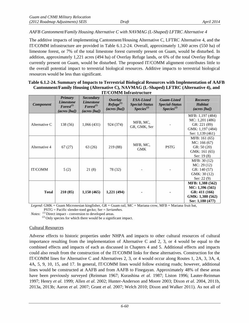
Guam and CNMI Military Relocation
(2012 Roadmap Adjustments) SEIS Draft April 2014
6-60
AAFB Cantonment/Family Housing Alternative C with NAVMAG (L-Shaped) LFTRC Alternative 4
The additive impacts of implementing Cantonment/Housing Alternative C, LFTRC Alternative 4, and the
IT/COMM infrastructure are provided in Table 6.1.2-24. Overall, approximately 1,360 acres (550 ha) of
limestone forest, or 7% of the total limestone forest currently present on Guam, would be disturbed. In
addition, approximately 1,221 acres (494 ha) of Overlay Refuge lands, or 6% of the total Overlay Refuge
currently present on Guam, would be disturbed. The proposed IT/COMM alignment contributes little to
the overall potential impact to terrestrial biological resources. Additive impacts to terrestrial biological
resources would be less than significant.
Table 6.1.2-24. Summary of Impacts to Terrestrial Biological Resources with Implementation of AAFB
Cantonment/Family Housing (Alternative C), NAVMAG (L-Shaped) LFTRC (Alternative 4), and
IT/COMM Infrastructure
Component
Primary
Limestone
Forest(1)
(acres [ha])
Secondary
Limestone
Forest(1)
(acres [ha])
Overlay
Refuge(1)
(acres [ha])
ESA-Listed
Special-Status
Species(2)
Guam-Listed
Special-Status
Species(2)
Recovery
Habitat
(acres [ha])
Alternative C 138 (56) 1,066 (431) 924 (374) MFB, MC,
GR, GMK, Ser -
MFB: 1,197 (484)
MC: 1,201 (486)
GR: 221 (89)
GMK: 1,197 (484)
Ser: 1,139 (461)
Alternative 4 67 (27) 63 (26) 219 (88) MFB, MC,
GMK PSTG
MFB: 161 (65)
MC: 166 (67)
GR: 50 (20)
GMK: 161 (65)
Ser: 19 (8)
IT/COMM 5 (2) 21 (8) 78 (32) - -
MFB: 30 (12)
MC: 29 (12)
GR: 140 (57)
GMK: 30 (12)
Ser: 22 (9)
Total 210 (85) 1,150 (465) 1,221 (494) - -
MFB: 1,388 (562)
MC: 1,396 (565)
GR: 411 (166)
GMK: 1,388 (562)
Ser: 1,180 (477)
Legend: GMK = Guam Micronesian kingfisher, GR = Guam rail, MC = Mariana crow, MFB = Mariana fruit bat,
PSTG = Pacific slender-toed gecko; Ser = Serianthes.
Notes: (1) Direct impact - conversion to developed areas.
(2) Only species for which there would be a significant impact.
Cultural Resources
Adverse effects to historic properties under NHPA and impacts to other cultural resources of cultural
importance resulting from the implementation of Alternative C and 2, 3, or 4 would be equal to the
combined effects and impacts of each as discussed in Chapters 4 and 5. Additional effects and impacts
could also result from the construction of the IT/COMM links for these alternatives. Construction for the
IT/COMM lines for Alternative C and Alternatives 2, 3, or 4 would occur along Routes 1, 2A, 3, 3A, 4,
4A, 5, 9, 10, 15, and 17. In general, IT/COMM lines would follow existing roads; however, additional
lines would be constructed at AAFB and from AAFB to Finegayan. Approximately 48% of these areas
have been previously surveyed (Reinman 1967; Kurashina et al. 1987; Liston 1996; Lauter-Reinman
1997; Henry et al. 1999; Allen et al. 2002; Hunter-Anderson and Moore 2003; Dixon et al. 2004, 2011b,
2013a, 2013b; Aaron et al. 2007; Grant et al. 2007; Welch 2010; Dixon and Walker 2011). As not all of

Guam and CNMI Military Relocation
(2012 Roadmap Adjustments) SEIS Draft April 2014
6-61
the routes have been surveyed, a literature review of previous surveys and sites located within the
construction corridor was undertaken and the likelihood of finding buried cultural resources within PDIA
for the IT/COMM lines corridor was assessed (Dixon et al. 2014). Within the PDIA for the IT/COMM
lines, approximately 19% of Route 1, 14% of Route 2A, 100% of Route 3, 94% of Route 3A, 5% of
Route 4, 9% of Route 4A, 39% of Route 5, 90%of Route 9, none of Route 10, 36% of Route 15, and 1%
of Route 17 have been surveyed.
Table 6.1.2-25 lists 16 known archaeological sites within the IT/COMM lines PDIA for Alternatives 2, 3,
and 4. Four of the sites, including a Japanese defensive complex, remnants of an historic encampment, a
Latte Period artifact scatter, and portions NWF, are eligible for listing in the NRHP. Twelve
archaeological sites are not eligible for listing in the NRHP. There is also a potential for buried cultural
resources along Routes 1, 5, 15, and 17 within unsurveyed areas.
Table 6.1.2-25. Archaeological Sites within IT/COMM Lines Potential Impacted area for the AAFB
Cantonment/Family Housing (Alternative C) and LFTRC Alternatives 2, 3, or 4
GHPI
Number†
Temporary
Site
Number/Map
Number*
Site Type Period Reference NRHP
Eligible?
NRHP
Criteria
36* Flagpole WWII/Second American
Administration Territorial
Lauter-Reinman
1997 No NA
235* Barracks
remains
Second American
Administration Territorial Welch et al. 2009 No NA
377* Ceramic scatter Pre-Contact/Latte Kurashina et al.
1987 No NA
1066*
MARBO base
command area
remnants –
concrete pads,
roads, other
remains
WWII American Military,
Second American
Administration Territorial
Welch 2010 No NA
66-02-
1657 493*
Japanese
defensive
complex
WWII Japanese Military Allen et al. 2002 Yes D
66-02-
2644 T-AP-002
Remains of
medical supply
storehouse no.
13
Second American
Administration Territorial Dixon et al. 2014 No NA
66-07-
2119 Artifact scatter Pre-Contact/Latte Welch 2010 No NA
66-07-
2124 Bottle dump
WWII/Second American
Administration Territorial Welch 2010 No NA
66-07-
2127 Artifact scatter Pre-Contact/Latte Welch 2010 No NA
66-07-
2128 Concrete pad
WWII, Second American
Administration Territorial Grant et al. 2007 No NA
66-08-
1065 NWF
Second American
Administration Territorial Aaron et al. 2007 Yes A
66-08-
2305 Encampment
Second American
Administration Territorial Welch 2010 Yes D
66-08-
2308 Artifact scatter Latte Welch 2010 Yes D
T-A4S-5 Concrete pads WWII/Second American
Administration Territorial
Dixon and Walker
2011 No NA

Guam and CNMI Military Relocation
(2012 Roadmap Adjustments) SEIS Draft April 2014
6-62
Table 6.1.2-25. Archaeological Sites within IT/COMM Lines Potential Impacted area for the AAFB
Cantonment/Family Housing (Alternative C) and LFTRC Alternatives 2, 3, or 4
GHPI
Number†
Temporary
Site
Number/Map
Number*
Site Type Period Reference NRHP
Eligible?
NRHP
Criteria
T-H-1
Artifact scatter
& concrete
foundations
WWII/Second American
Administration Territorial
Dixon and Walker
2011 No NA
T-WAW-016 Bottle scatter
Latte/Japanese
Administration/Second
American Administration
Territorial
Dixon et al. 2014 No NA
Legend: GHPI = Guam Historic Properties Inventory; NRHP = National Register of Historic Places; NA=not applicable; NRHP
criterion A = eligible because they are associated with events that have made a significant contribution to the broad pattern of
history, criterion D = eligible for potential to yield information important in prehistory or history.
Notes: †Not all sites recorded within the project areas have received official GHPI numbers, although they have been documented as
part of previous surveys.
*Welch (2009) (Map no. 36, 235, 377, and 493) or Welch (2010) (Map no. 1066).
One structure eligible for listing in the NRHP, North Field, is located within the potential impacted area
for Alternatives 2, 3, and 4. No TCPs have been identified in the potential impacted areas for the
IT/COMM lines.
The installation of IT/COMM links between Alternative C and the LFTRC Alternatives 2, 3, or 4 has the
potential to result in adverse effects from excavation and soil removal to five historic properties-- four
known NRHP-eligible archaeological sites (see Table 6.1.2-25) and one NRHP-eligible structure (North
Field), as well as undetermined effects to possible buried cultural resources in unsurveyed areas along
Routes 1, 5, 15, and 17. Based on an examination of previous investigations and predictive modeling,
there is a low potential for NRHP-eligible sites in the remaining areas. No TCPs would be directly
affected by the construction of the IT/COMM links.
No direct or indirect adverse effects due to operation of the IT/COMM utilities would occur as these lines
would be buried and there would be no change in use, and no effects to the setting.
The 2011 PA, as discussed in Section 3.10.2, establishes a program alternative for complying with NHPA
Section 106 requirements. To the degree possible, impacts to historic properties and other resources of
cultural importance would be avoided during the planning process. Consultation under the 2011 PA will
address potential adverse effects and alternatives to avoid adverse effects. If avoidance is not possible,
potential minimization and mitigation measures may include data recovery and monitoring during
construction in areas with likelihood for buried cultural resources. However, final mitigation will be
determined after completion of the consultation process outlined in the PA. With the implementation of
these measures and processes as outlined in the 2011 PA, additive impacts associated with IT/COMM
would be reduced to a level below significance.
Ground Transportation
Alternative C was modeled with Alternative 2 or 4 (Section 3.12.1). Pairing Alternative C with
Alternative 3 may result in a slight increase (less than 5%) in vehicles on roadway segments and at
intersections that comprise the most direct route between the Alternative C Main Gate and the Alternative
3 gate, and a slight decrease in vehicles on roadway segments and at intersections that comprise the most
direct route between the modeled combination, Alternative C Main Gate and the Alternative 2 or 4 gates
(see Figure 6.1.2-1). This minimal incremental increase or decrease in traffic volumes would not

Guam and CNMI Military Relocation
(2012 Roadmap Adjustments) SEIS Draft April 2014
6-63
adversely affect level of service on roadways or at intersections along the route.
Although significant impacts would occur at all locations, potential mitigation measures have not been
identified for any of the impacted roadway segments or intersections. Potential mitigation measures for
would be similar in scope and scale to those identified in Section 6.1.2.1. However, the exact details of
the improvements would require further evaluations and technical studies to determine their feasibility.
The final list of implementable mitigation measures will be dependent on the selected alternative or
combination of alternatives and based on project-level technical studies, to be conducted after the
alternative or combination of alternatives is selected. FHWA will conduct all NEPA documentation
efforts and any associated resource consultations as specific mitigation measures are proposed.
Roadway Segment Operations. Impacts to all off-base (external) roadway segments would be the same as
those identified in Section 6.1.2.4. Significant impacts were identified on six roadway segments. The
detailed results of the roadway segment analysis are provided in their entirety in Appendix F.
Intersection Operations. Impacts to all intersections would be the same as those identified in Section
6.1.2.4 (see Table 6.1.2-21). Significant impacts were identified at 11 intersections. The detailed results of
the intersection analysis are provided in its entirety in Appendix F.
Transit Conditions. Transit conditions under Alternative C with Alternative 2, 3, or 4 would be the same
as those described in Section 6.1.2.1 for Alternative A with Alternative 1.
Pedestrian and Bicycle Conditions. Pedestrian and bicycle conditions under Alternative C with
Alternative 2, 3, or 4 would be the same as those described in Section 6.1.2.1 for Alternative A with
Alternative 1.
Public Health and Safety
The potential for traffic incidents is the primary health and safety issue with potential for having additive
impacts from implementing a specific cantonment/family housing alternative with a specific LFTRC
alternative. The driving distance between the Alternative C area and Alternatives 2, 3, and 4 is
approximately 24.6 miles (39.6 km) to Alternative 2, and 30.2 miles (48.6 km) to Alternatives 3 and 4.
Vehicles would use Routes 1 and 3 to commute between the Alternative C area and Alternative 2, while
Routes 3, 4, 10, and 16, as well as a new roadway in Dandan, would be used to access Alternatives 3 and
4.
Five high-crash frequency intersections (intersections of Routes 1/3, Routes 1/14A, Routes 1/10A, Routes
1/14, and Routes 1/30) are situated along the travel route between the Alternative C area and Alternative
2. These intersections are primarily in the central portion of Guam in the most highly developed area of
the island, within the communities of Hagåtña and Tamuning. Two high-crash frequency intersections
(intersection of Routes 1/3 and Routes 8/10/16) are situated along the travel route between the Alternative
C area and Alternatives 3 and 4. The travel distance between the Alternative C area and Alternatives 2, 3,
and 4 is relatively long, and several high-frequency crash intersections are situated along the travel routes
(resulting in a higher potential for being involved in a traffic incident or to be delayed because of traffic
incidents). However, a less-than-significant additive impact on public health and safety would occur since
the additional vehicles traveling between the main cantonment and LFTRC would be an insignificant
portion of total vehicles on these roadways.

Guam and CNMI Military Relocation
(2012 Roadmap Adjustments) SEIS Draft April 2014
6-64
AAFB Cantonment/Family Housing Alternative C with NWF LFTRC Alternative 5 6.1.2.6
Air Quality
The combined air quality impacts would be the same as those described in Section 6.1.2.4. The combined
construction island-wide emissions, summarized in Table 6.1.2-18, would be less than significant as a
result of these combined alternatives.
Terrestrial Biological Resources
The additive impacts of implementing Cantonment/Family Housing Alternative C, LFTRC Alternative 5,
and the IT/COMM infrastructure are provided in Table 6.1.2-26. Overall, approximately 1,431 acres (579
ha) of limestone forest, or 8% of the total limestone forest currently present on Guam, would be disturbed.
In addition, approximately 1,256 acres (508 ha) of Overlay Refuge lands, or 6% of the total Overlay
Refuge currently present on Guam, would be disturbed. The proposed IT/COMM alignment contributes
little to the overall potential impact to terrestrial biological resources. Additive impacts to terrestrial
biological resources would be less than significant.
Table 6.1.2-26. Summary of Impacts to Terrestrial Biological Resources with Implementation of AAFB
Cantonment/Family Housing (Alternative C), NWF LFTRC (Alternative 5),
and IT/COMM Infrastructure
Component
Primary
Limestone
Forest(1)
(acres [ha])
Secondary
Limestone
Forest(1)
(acres [ha])
Overlay
Refuge(1)
(acres [ha])
ESA-Listed
Special-Status
Species(2)
Guam-Listed
Special-Status
Species(2)
Recovery
Habitat
(acres [ha])
Critical
Habitat
(acres [ha])
Alternative C 138 (56) 1,066 (431) 924 (374) MFB, MC,
GR, GMK, Ser -
MFB: 1,197 (484)
MC: 1,201 (486)
GR: 221 (89)
GMK: 1,197 (484)
Ser: 1,139 (461)
NA
Alternative 5 90 (37) 111 (45) 254 (103) MFB, MC,
GMK, Ser -
MFB: 196 (79)
MC: 196 (79)
GR: 40 (16)
GMK: 196 (79)
Ser: 154 (62)
MFB, MC,
GMK: 12
(5)
IT/COMM 5 (2) 21 (8) 78 (32) - -
MFB: 30 (12)
MC: 29 (12)
GR: 140 (57)
GMK: 30 (12)
Ser: 22 (9)
NA
Total 233 (94) 1,198 (485) 1,256 (508) - -
MFB: 1,423 (576)
MC: 1,426 (577)
GR: 401 (162)
GMK: 1,423 (576)
Ser: 1,315 (532)
-
Legend: GMK = Guam Micronesian kingfisher, GR = Guam rail, MC = Mariana crow, MFB = Mariana fruit bat, NA = not applicable;
Ser = Serianthes.
Notes: (1) Direct impact - conversion to developed areas.
(2) Only species for which there would be a significant impact.
Cultural Resources
Adverse effects to historic properties under NHPA and impacts to other cultural resources of cultural
importance resulting from the implementation of Alternatives C and 5 would be equal to the combined
effects and impacts of each as discussed in Chapters 4 and 5. Additional effects and impacts could also
result from the construction of the IT/COMM links for these alternatives. Construction for the IT/COMM
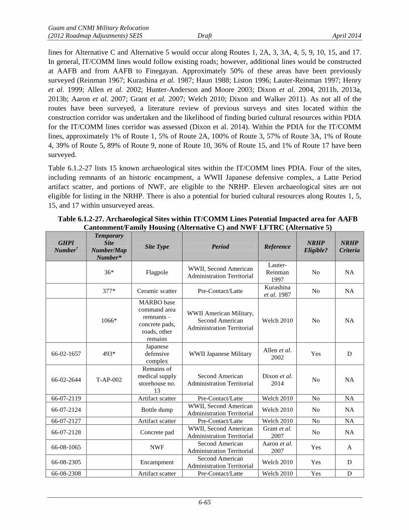
Guam and CNMI Military Relocation
(2012 Roadmap Adjustments) SEIS Draft April 2014
6-65
lines for Alternative C and Alternative 5 would occur along Routes 1, 2A, 3, 3A, 4, 5, 9, 10, 15, and 17.
In general, IT/COMM lines would follow existing roads; however, additional lines would be constructed
at AAFB and from AAFB to Finegayan. Approximately 50% of these areas have been previously
surveyed (Reinman 1967; Kurashina et al. 1987; Haun 1988; Liston 1996; Lauter-Reinman 1997; Henry
et al. 1999; Allen et al. 2002; Hunter-Anderson and Moore 2003; Dixon et al. 2004, 2011b, 2013a,
2013b; Aaron et al. 2007; Grant et al. 2007; Welch 2010; Dixon and Walker 2011). As not all of the
routes have been surveyed, a literature review of previous surveys and sites located within the
construction corridor was undertaken and the likelihood of finding buried cultural resources within PDIA
for the IT/COMM lines corridor was assessed (Dixon et al. 2014). Within the PDIA for the IT/COMM
lines, approximately 1% of Route 1, 5% of Route 2A, 100% of Route 3, 57% of Route 3A, 1% of Route
4, 39% of Route 5, 89% of Route 9, none of Route 10, 36% of Route 15, and 1% of Route 17 have been
surveyed.
Table 6.1.2-27 lists 15 known archaeological sites within the IT/COMM lines PDIA. Four of the sites,
including remnants of an historic encampment, a WWII Japanese defensive complex, a Latte Period
artifact scatter, and portions of NWF, are eligible to the NRHP. Eleven archaeological sites are not
eligible for listing in the NRHP. There is also a potential for buried cultural resources along Routes 1, 5,
15, and 17 within unsurveyed areas.
Table 6.1.2-27. Archaeological Sites within IT/COMM Lines Potential Impacted area for AAFB
Cantonment/Family Housing (Alternative C) and NWF LFTRC (Alternative 5)
GHPI
Number†
Temporary
Site
Number/Map
Number*
Site Type Period Reference NRHP
Eligible?
NRHP
Criteria
36* Flagpole WWII, Second American
Administration Territorial
Lauter-
Reinman
1997
No NA
377* Ceramic scatter Pre-Contact/Latte Kurashina
et al. 1987 No NA
1066*
MARBO base
command area
remnants –
concrete pads,
roads, other
remains
WWII American Military,
Second American
Administration Territorial
Welch 2010 No NA
66-02-1657 493*
Japanese
defensive
complex
WWII Japanese Military Allen et al.
2002 Yes D
66-02-2644 T-AP-002
Remains of
medical supply
storehouse no.
13
Second American
Administration Territorial
Dixon et al.
2014 No NA
66-07-2119 Artifact scatter Pre-Contact/Latte Welch 2010 No NA
66-07-2124 Bottle dump WWII, Second American
Administration Territorial Welch 2010 No NA
66-07-2127 Artifact scatter Pre-Contact/Latte Welch 2010 No NA
66-07-2128 Concrete pad WWII, Second American
Administration Territorial
Grant et al.
2007 No NA
66-08-1065 NWF Second American
Administration Territorial
Aaron et al.
2007 Yes A
66-08-2305 Encampment Second American
Administration Territorial Welch 2010 Yes D
66-08-2308 Artifact scatter Pre-Contact/Latte Welch 2010 Yes D

Guam and CNMI Military Relocation
(2012 Roadmap Adjustments) SEIS Draft April 2014
6-66
GHPI
Number†
Temporary
Site
Number/Map
Number*
Site Type Period Reference NRHP
Eligible?
NRHP
Criteria
T-H20-1
Water catchment
with pump
generator and
fuel tank
foundations
WWII, Second American
Administration Territorial
Dixon and
Walker
2011
No NA
T-A4S-5 Concrete pads WWII, Second American
Administration Territorial
Dixon and
Walker
2011
No NA
T-WAW-016 Bottle scatter
Pre-Contact/Latte;
Japanese Administration,
Second American
Administration Territorial
Dixon et al.
2014 No NA
Legend: GHPI = Guam Historic Properties Inventory; NRHP = National Register of Historic Places; NA=not applicable; NRHP
criterion A = eligible because they are associated with events that have made a significant contribution to the broad
pattern of history, criterion D = eligible for potential to yield information important in prehistory or history.
Notes: †Not all sites recorded within the project areas have received official GHPI numbers, although they have been
documented as part of previous surveys.
*From Welch (2009) (Map no. 36, 377, 493) and Welch (2010) (Map no. 1066).
One structure eligible for listing in the NRHP, North Field, is located within the potential impacted area.
No TCPs have been identified in the potential impacted areas for the IT/COMM lines.
The installation of IT/COMM links between Alternative C and the LFTRC Alternative 5 has the potential
to result in adverse effects from excavation and soil removal to five historic properties--four NRHP-
eligible archaeological sites (see Table 6.1.2-27) and one NRHP-eligible structure (North Field), as well
as undetermined effects to possible buried cultural resources in unsurveyed areas along Routes 1, 5, 15,
and 17. Based on an examination of previous investigations and predictive modeling, there is a low
potential for NRHP-eligible sites in the remaining areas. No TCPs would be directly affected by the
construction of the IT/COMM links.
No direct or indirect adverse effects due to operation of the IT/COMM utilities would occur as these lines
would be buried and there would be no change in use, and no effects to the setting.
The 2011 PA, as discussed in Section 3.10.2, establishes a program alternative for complying with NHPA
Section 106 requirements. To the degree possible, impacts to historic properties and other resources of
cultural importance would be avoided during the planning process. Consultation under the 2011 PA will
address potential adverse effects and alternatives to avoid adverse effects. If avoidance is not possible,
potential minimization and mitigation measures may include data recovery and monitoring during
construction in areas with likelihood for buried cultural resources. However, final mitigation will be
determined after completion of the consultation process outlined in the PA. With the implementation of
these measures and processes as outlined in the 2011 PA, additive impacts associated with IT/COMM
would be reduced to a level below significance.
Ground Transportation
Alternative C was modeled with Alternative 2 or 4 (Section 3.12.1). Pairing Alternative C with
Alternative 5 may result in a slight increase (less than 5%) in vehicles on roadway segments and at
intersections that comprise the most direct route between the Alternative C Main Gate and the Alternative
5 gate and a slight decrease in vehicles on roadway segments and at intersections that comprise the most
direct route between the modeled combination, Alternative C Main Gate and the Alternative 2 or 4 gate

Guam and CNMI Military Relocation
(2012 Roadmap Adjustments) SEIS Draft April 2014
6-67
(see Figure 6.1.2-3). This minimal incremental increase or decrease in traffic volumes would not
adversely affect level of service on roadways or at intersections along the route.
Although significant impacts would occur at all locations, potential mitigation measures have not been
identified for any of the impacted roadway segments or intersections. Potential mitigation measures
would be similar in scope and scale to those identified in Section 6.1.2.1. However, the exact details of
the improvements would require further evaluations and technical studies to determine their feasibility.
The final list of implementable mitigation measures will be dependent on the selected alternative or
combination of alternatives and based on project-level technical studies, to be conducted after the
alternative or combination of alternatives is selected. FHWA will conduct all NEPA documentation
efforts and any associated resource consultations as specific mitigation measures are proposed.
Roadway Segment Operations. Impacts to all off-base (external) roadway segments would be the same as
those identified in Section 6.1.2.4. Significant impacts were identified on six roadway segments. The
detailed results of the roadway segment analysis are provided in their entirety in Appendix F.
Intersection Operations. Impacts to all intersections would be the same as those identified in Section
6.1.2.4 (Table 6.1.2-21). Significant impacts were identified at 11 intersections. The detailed results of the
intersection analysis are provided in its entirety in Appendix F.
Transit Conditions. Transit conditions under Alternative C with Alternative 5 would be the same as those
described in Section 6.1.2.1for Alternative A with Alternative 1.
Pedestrian and Bicycle Conditions. Pedestrian and bicycle conditions under Alternative C with
Alternative 5 would be the same as those described in Section 6.1.2.1for Alternative A with Alternative 1.
Public Health and Safety
The potential for traffic incidents is the primary health and safety issue with potential for having additive
impacts from implementing a specific cantonment/family housing alternative with a specific LFTRC
alternative. The driving distance between the Alternative C area and Alternative 5 is approximately 6.5
miles. Vehicles would use Routes 9 and 3A to commute between the Alternative C area and Alternative 5.
No high-crash frequency intersections are situated along this travel route. Because the travel distance
between the Alternative C area and Alternative 5 is relatively short and there are no high-frequency crash
intersections situated along the travel route, no significant additive traffic impacts would occur.
Barrigada Cantonment/Family Housing Alternative D with Route 15 LFTRC Alternative 1 6.1.2.7
Air Quality
The combined air quality impacts would be similar to those described in Section 6.1.2.1.
The combined construction island-wide emissions impacts, summarized in Table 6.1.2-28, would be
below the significance criterion of 250 tpy for criteria pollutants resulting in less than significant as a
result of this combined alternative.

Guam and CNMI Military Relocation
(2012 Roadmap Adjustments) SEIS Draft April 2014
6-68
Table 6.1.2-28. Barrigada Cantonment/Family Housing (Alternative D) with Route 15 LFTRC
(Alternative 1, 2, 3, 4 or 5) Annual Construction Emissions (2016-2022) Construction
Year
Pollutant (tpy)
SO2 CO PM10 PM2.5 NOx VOC CO2
2016 neg neg neg neg neg neg neg
2017 0.1 4.8 0.4 0.4 6.2 0.8 933.6
2018 0.5 31.3 2.0 1.8 23.6 4.2 4784.0
2019 0.6 43.9 2.6 2.3 30.8 5.2 6825.0
2020 0.3 20.3 1.2 1.0 12.5 2.8 2779.4
2021 0.7 41.4 2.5 2.2 32.1 4.3 7096.1
2022 0.3 19.0 1.2 1.0 14.7 2.0 3256.4
Significance Threshold 250 250 250 250 250 250 NA
Legend: CO = Carbon Monoxide; CO2 = Carbon Dioxide; NOx= Nitrogen Oxides; PM10 = Particulate Matter (<10 microns);
PM2.5= Particulate Matter (<2.5 microns); SO2 = Sulfur Dioxide; VOC= Volatile Organic Compounds; neg = negligible;
NA = not available.
Terrestrial Biological Resources
The additive impacts of implementing Cantonment Housing Alternative D, LFTRC Alternative 1, and the
IT/COMM infrastructure are provided in Table 6.1.2-29. Overall, approximately 552 acres (224 ha) of
limestone forest, or 3% of the total limestone forest currently present on Guam, would be disturbed. In
addition, approximately 153 acres (62 ha) of Overlay Refuge lands, or <1% of the total Overlay Refuge
currently present on Guam, would be disturbed. In regards to recovery habitat for ESA-listed species, the
greatest impact would be to Guam rail recovery habitat with 1,276 acres (516 ha) developed, mostly
associated with Alternative D. The proposed IT/COMM alignment contributes little to the overall
potential impact to terrestrial biological resources. Additive impacts to terrestrial biological resources
would be less than significant.
Table 6.1.2-29. Summary of Impacts to Terrestrial Biological Resources with Implementation of
Barrigada Cantonment/Family Housing (Alternative D), Route 15 LFTRC (Alternative 1),
and IT/COMM Infrastructure
Component
Primary
Limestone
Forest(1)
(acres [ha])
Secondary
Limestone
Forest(1)
(acres [ha])
Overlay
Refuge(1)
(acres [ha])
ESA-Listed
Special-Status
Species(2)
Guam-Listed
Special-Status
Species(2)
Recovery
Habitat
(acres [ha])
Alternative D 99 (40) 167 (68) 75 (30) GR -
MFB: 83 (34)
MC: 83 (34)
GR: 849 (344)
GMK: 83 (34)
Ser: 81 (3)
Alternative 1 65 (26) 190 (77) NA GR -
MFB: 81 (33)
MC: 81 (33)
GR: 283 (115)
GMK: 81 (33)
Ser: 67 (27)
IT/COMM 6 (2) 25 (10) 78 (32) - -
MFB: 50 (20)
MC: 50 (20)
GR: 144 (58)
GMK: 50 (20)
Ser: 42 (17)
Total 170 (69) 382 (155) 153 (62) - -
MFB: 214 (87)
MC: 214 (87)
GR: 1,276 (516)
GMK: 214 (87)
Ser: 190 (77) Legend: GMK = Guam Micronesian kingfisher, GR = Guam rail, MC = Mariana crow, MFB = Mariana fruit bat, Ser = Serianthes.
Notes: (1) Direct impact - conversion to developed areas. (2) Only species for which there would be a significant impact.

Guam and CNMI Military Relocation
(2012 Roadmap Adjustments) SEIS Draft April 2014
6-69
Cultural Resources
Adverse effects to historic properties under NHPA and impacts to other cultural resources of cultural
importance resulting from the implementation of Alternatives D and 1 would be equal to the combined
effects and impacts of each as discussed in Chapters 4 and 5. Additional effects and impacts could also
result from the construction of the IT/COMM links for these alternatives. Construction for the IT/COMM
lines for Alternative D and Alternative 1 would occur along Routes 1, 2A, 3, 3A, 4, 5, 8, 9, 10, 15, 16,
and 17. In general, IT/COMM lines would follow existing roads; however, additional lines would be
constructed at AAFB and from AAFB to Finegayan. Approximately 45% of these areas have been
previously surveyed (Reinman 1967; Kurashina et al. 1987; Liston 1996; Lauter-Reinman 1997; Olmo et
al. 2002; Hunter-Anderson and Moore 2003; Dixon et al. 2004, 2011a, 2013a, 2013b; Aaron et al. 2007;
Grant et al. 2007; Athens, 2009; Welch 2010; Dixon and Walker 2011). As not all of the routes have been
surveyed, a literature review of previous surveys and sites located within the construction corridor was
undertaken and the likelihood of finding buried cultural resources within PDIA for the IT/COMM lines
corridor was assessed (Dixon et al. 2014). Within the PDIA for the IT/COMM lines, approximately 14%
of Route 1, 4% of Route 2A, 100% of Route 3, 94% of Route 3A, 1% of Route 4, 39% of Route 5, 5% of
Route 8, 87% of Route 9, none of Route 10, 57% of Route 15, 61% of Route 16, 1and 1% of Route 17
have been surveyed.
Table 6.1.2-30 lists 16 known archaeological sites within the IT/COMM lines PDIA. Five of the sites,
including remnants of an historic encampment, a WWII Japanese defensive complex, two Latte Period
artifact scatters, and portions of NWF, are eligible to the NRHP. Eleven archaeological sites are not
eligible for listing in the NRHP. There is also a potential for buried cultural resources along Routes 1, 5,
15, and 17 within unsurveyed areas
Table 6.1.2-30. Archaeological Sites within the IT/COMM Lines Potential Impacted Area for Barrigada
Cantonment/Family Housing (Alternative D) and the Route 15 LFTRC (Alternative 1)
GHPI
Number†
Temporary
Site
Number/
Map
Number*
Site Type Period Reference NRHP
Eligible?
NRHP
Criteria
36* Flagpole WWII/Second American
Administration Territorial
Lauter-Reinman
1997 No NA
377* Ceramic Scatter Pre-Contact/Latte Kurashina et al.
1987 No NA
1066*
MARBO base
command area
remnants –
concrete pads,
roads, other
remains
WWII American Military,
Second American
Administration Territorial
Welch 2010 No NA
66-02-1657 493*
Japanese
defensive
complex
WWII Japanese Military Allen et al. 2002 Yes D
66-02-2644 T-AP-002
Remains of
medical supply
storehouse no.
13
Second American
Administration Territorial Dixon et al. 2014 No NA
66-07-2119 Artifact scatter Pre-Contact/Latte Welch 2010 No NA
66-07-2124 Bottle dump WWII/Second American
Administration Territorial Welch 2010 No NA
66-07-2127 Artifact scatter Pre-Contact/Latte Welch 2010 No NA
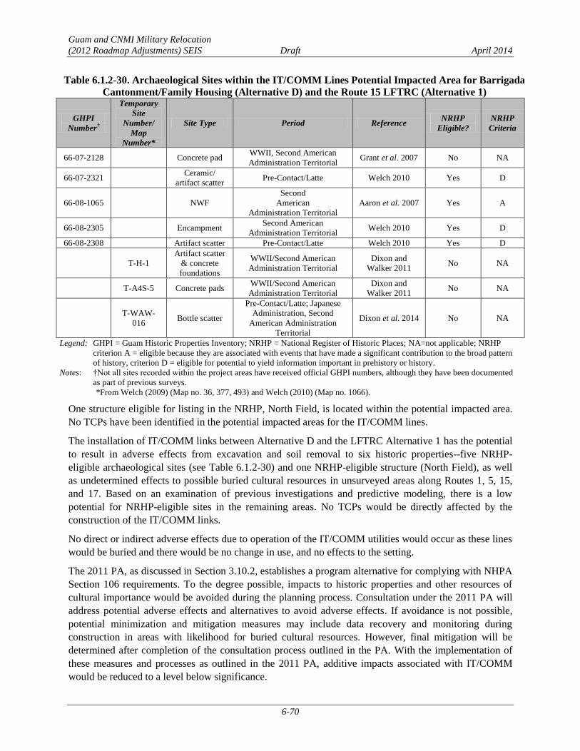
Guam and CNMI Military Relocation
(2012 Roadmap Adjustments) SEIS Draft April 2014
6-70
Table 6.1.2-30. Archaeological Sites within the IT/COMM Lines Potential Impacted Area for Barrigada
Cantonment/Family Housing (Alternative D) and the Route 15 LFTRC (Alternative 1)
GHPI
Number†
Temporary
Site
Number/
Map
Number*
Site Type Period Reference NRHP
Eligible?
NRHP
Criteria
66-07-2128 Concrete pad WWII, Second American
Administration Territorial Grant et al. 2007 No NA
66-07-2321 Ceramic/
artifact scatter Pre-Contact/Latte Welch 2010 Yes D
66-08-1065 NWF
Second
American
Administration Territorial
Aaron et al. 2007 Yes A
66-08-2305 Encampment Second American
Administration Territorial Welch 2010 Yes D
66-08-2308 Artifact scatter Pre-Contact/Latte Welch 2010 Yes D
T-H-1
Artifact scatter
& concrete
foundations
WWII/Second American
Administration Territorial
Dixon and
Walker 2011 No NA
T-A4S-5 Concrete pads WWII/Second American
Administration Territorial
Dixon and
Walker 2011 No NA
T-WAW-
016 Bottle scatter
Pre-Contact/Latte; Japanese
Administration, Second
American Administration
Territorial
Dixon et al. 2014 No NA
Legend: GHPI = Guam Historic Properties Inventory; NRHP = National Register of Historic Places; NA=not applicable; NRHP
criterion A = eligible because they are associated with events that have made a significant contribution to the broad pattern
of history, criterion D = eligible for potential to yield information important in prehistory or history.
Notes: †Not all sites recorded within the project areas have received official GHPI numbers, although they have been documented
as part of previous surveys.
*From Welch (2009) (Map no. 36, 377, 493) and Welch (2010) (Map no. 1066).
One structure eligible for listing in the NRHP, North Field, is located within the potential impacted area.
No TCPs have been identified in the potential impacted areas for the IT/COMM lines.
The installation of IT/COMM links between Alternative D and the LFTRC Alternative 1 has the potential
to result in adverse effects from excavation and soil removal to six historic properties--five NRHP-
eligible archaeological sites (see Table 6.1.2-30) and one NRHP-eligible structure (North Field), as well
as undetermined effects to possible buried cultural resources in unsurveyed areas along Routes 1, 5, 15,
and 17. Based on an examination of previous investigations and predictive modeling, there is a low
potential for NRHP-eligible sites in the remaining areas. No TCPs would be directly affected by the
construction of the IT/COMM links.
No direct or indirect adverse effects due to operation of the IT/COMM utilities would occur as these lines
would be buried and there would be no change in use, and no effects to the setting.
The 2011 PA, as discussed in Section 3.10.2, establishes a program alternative for complying with NHPA
Section 106 requirements. To the degree possible, impacts to historic properties and other resources of
cultural importance would be avoided during the planning process. Consultation under the 2011 PA will
address potential adverse effects and alternatives to avoid adverse effects. If avoidance is not possible,
potential minimization and mitigation measures may include data recovery and monitoring during
construction in areas with likelihood for buried cultural resources. However, final mitigation will be
determined after completion of the consultation process outlined in the PA. With the implementation of
these measures and processes as outlined in the 2011 PA, additive impacts associated with IT/COMM
would be reduced to a level below significance.

Guam and CNMI Military Relocation
(2012 Roadmap Adjustments) SEIS Draft April 2014
6-71
Ground Transportation
The travel demand modeling methodology for the combination of alternatives was defined and directed
by the DoD and the FHWA to provide detailed off-base (external) roadway and intersection analysis for
one representative pairing (the modeled combination) for a cantonment/family housing alternative and
LFTRC site alternative. The modeled combination for Alternative D involved a pairing with Alternative 5
(see Section 3.12.1). Modeling results for this scenario indicate that weekday a.m. peak hour vehicle
traffic related to the proposed action is generated solely by operations at the cantonment/family housing
area. LFTRC-related traffic would occur prior to the start weekday a.m. peak hour (8:00 a.m.) and may
coincide with the weekday p.m. peak hour (4:30 p.m. to 5:30 p.m.) (see Section 5.1.12).
Operations of the LFTRC would increase traffic on the off-base (external) roadway segments and intersections
that comprise the most direct route between the main cantonment gate and the LFTRC gates by approximately
38 vehicles (measured in passenger car equivalents) (see Table 5.1.12-2). LFTRC-related traffic represents an
insubstantial amount of traffic (less than 5%) along the route. This minimal incremental increase in traffic
volumes would not adversely affect level of service on roadways or at intersections along the route. The
relative contribution from LFTRC traffic to the off-base (external) roadway segments and intersections under
each cantonment/family housing alternative would be minimal and would not vary appreciably with any
LFTRC alternative (Alternative 1, 2, 3, 4, and 5). Therefore, the impacts to the off-base (external) roadway
segments and intersections would be essentially the same for Alternative D with Alternative 1, Alternative D
with Alternative 2, 3, or 4, and Alternative D with Alternative 5. A qualitative discussion of the potential
effects of LFTRC-related traffic is provided for each combination.
Pairing Alternative D with Alternative 1 may result in a slight increase in vehicles (less than 5%) on
roadway segments and at intersections that comprise the most direct route between the Alternative D
Main Gate and the Alternative 1 gate, and a slight decrease in vehicles compared to the modeled
combination of Alternative D Main Gate and the Alternative 5 gate (Figure 6.1.2-4). This minimal
incremental increase or decrease in traffic volumes would not adversely affect level of service on
roadways or at intersections along the route. The impacts to off-base (external) roadway segments and
intersections are summarized in Table 6.1.2-31.
Table 6.1.2-31. Summary of Additive Impacts to Ground Transportation Resources with the Barrigada
Cantonment/Family Housing (Alternative D) and any LFTRC # Roadway Segments* Intersections
1 Route 15, from Route 29 to Route 26 (SI) Route 15 / Chalan Lajuna (SI)
2 Route 1, from Route 30 to Route 8 (SI) Route 1 / Route 27 (SI)**
3 Route 1, from Route 6 (N) to Route 11 (SI) Route 1 / Route 26 (SI)**
4 Route 8, from Route 10 to Route 33 (E) (SI) Route 16 / Route 27 (SI)**
5 Route 8, from Route 33 (E) to Route 33 (W) (SI) Route 15 / Route 26 (SI)
6 Route 8, from Route 33 (W) to Route 1 (SI) Route 1 / Route 10A (SI)**
7 Route 10, from Route 8 to Route 15 (SI) Route 8 / Chalan Santo Papa (SI)
8 Route 10, from Route 15 to Route 32 (SI) Route 4 / Route 7B (SI)
9 Route 15, from Route 26 to Barrigada South Gate (SI) NA
10 Route 15, from Barrigada South Gate to Route 10 (SI) NA
11 Route 16, from Route 10A to Barrigada Main Gate (SI) NA
12 Route 26, from Route 25 to Route 15 (SI) NA
Total 12, SI 8, SI Legend: NA indicates Not Applicable. SI indicates significant impact.
Notes: *Includes impacts to roadway segments in at least one direction during one (or both) weekday a.m. or p.m. peak hours.
** Indicates a significant but mitigable impact has been identified at this location under Year 2030 Alternative A.

LFTRC NWFAlternative (Alt. 5)
LFTRC Route 15Alternative (Alt. 1)
LFTRC NAVMAG East/WestAlternative (Alt. 2)
LFTRC NAVMAG L-ShapedAlternative (Alt. 4)
LFTRC NAVMAG North/SouthAlternative (Alt. 3)
NWF
FINEGAYAN
SOUTHFINEGAYAN
AAFB
MT SANTAROSA
AAFB SOUTH
Barrigada Cantonment/FamilyHousing Alternative (Alt. D)
NAVMAG
NAVALBASE GUAM
SASA VALLEYTANK FARM
NAVALHOSPITAL
DededoYigo
Tamuning
HAGATNA
Inarajan
Umatac
Agat
APRA HEIGHTS
Barrigada to LFTRC NWFAlternative Modeled Combination
Figure 6.1.2-4Travel Routes from Barrigada Cantonment/FamilyHousing (Alternative D) to the LFTRC Alternatives
LegendTravel Routes from Barrigada Cantonment/FamilyHousing (Alternative D) to the LFTRC Alternatives
NWF (16.9 mi/27.2 km)Route 15 (5.8 mi/9.3 km)NAVMAG East-West (17 mi/27.4 km)NAVMAG L-Shaped (17 mi/27.4 kmi)NAVMAG North-South (17.7 mi/28.5 kmi)HighwaysAirfieldsBarrigada Cantonment/Family Housing Alternative (Alt. D)LFTRC AlternativesDoD Properties
P h i l i p p i n eS e a
P a c i f i cO c e a n
Guam
Area of Detail
1 " = 237 Miles
0 2 4Miles
0 2 4Kilometers
Source: NAVFAC Pacific 2013
P h i l i p p i n eS e a
P a c i f i cO c e a n
6-72

Guam and CNMI Military Relocation
(2012 Roadmap Adjustments) SEIS Draft April 2014
6-73
Roadway Segment Operations. A capacity analysis was conducted to determine potential impacts to the
off-base (external) roadway network during weekday a.m. and p.m. peak hours. The volume-to-capacity
ratio and LOS for each study roadway segment is compared to the baseline conditions to determine if any
significant impacts would occur. The detailed results of the roadway segment analysis are provided in
their entirety in Appendix F.
The addition of traffic generated by the proposed action would result in a potentially significant impact on
12 study roadway segments in at least one direction during the weekday a.m. and/or weekday p.m. peak
hours.
Route 15, from Route 26 to Route 29. This study roadway segment currently operates at
acceptable LOS E with a v/c ratio of 0.96 in the southbound/westbound direction during the
weekday a.m. peak hour under Existing Conditions. This study roadway segment would operate
at unacceptable LOS F with a v/c ratio of 1.08 in the southbound/westbound direction during the
weekday a.m. peak hour under Year 2030 Baseline Conditions. Under Year 2030 Barrigada
Cantonment/Family Housing (Alternative D) Conditions, this study roadway segment would
continue to operate at LOS F with a v/c ratio of 1.17. The proposed action would increase traffic
on this study roadway segment by approximately 63 vehicles during the weekday a.m. peak hour.
This 7.5% increase in traffic exceeds the 5.0% threshold of significance. Therefore, the proposed
action would result in a significant impact in the southbound/westbound direction on this study
roadway segment during the weekday p.m. peak hour.
Route 1, from Route 30 to Route 8. This study roadway segment currently operates at acceptable
LOS E with a v/c ratio of 0.91 in the northbound/eastbound direction during the weekday a.m.
peak hour under Existing Conditions. This study roadway segment would operate at acceptable
LOS E with a v/c ratio of 0.98 in the northbound/eastbound direction during the weekday a.m.
peak hour under Year 2030 Baseline Conditions. Under Year 2030 Barrigada Cantonment/Family
Housing (Alternative D) Conditions, this study roadway segment would degrade to unacceptable
LOS F with a v/c ratio of 1.01. Therefore, the proposed action would result in a significant impact
in the northbound/eastbound direction on this study roadway segment during the weekday a.m.
peak hour.
Route 1, from Route 6 (N) to Route 11. This study roadway segment currently operates at LOS E
with a v/c ratio of 0.99 in the southbound/westbound direction during the weekday a.m. peak hour
under Existing Conditions. This study roadway segment would operate at unacceptable LOS F
with a v/c ratio of 1.05 in the southbound/westbound direction during the weekday a.m. peak hour
under Year 2030 Baseline Conditions. Under Year 2030 Barrigada Cantonment/Family Housing
(Alternative D) Conditions, this study roadway segment would continue to operate at
unacceptable LOS F with a v/c ratio of 1.11 in the southbound/westbound direction. The
proposed action would increase traffic on this study roadway segment by approximately 95
vehicles during the weekday a.m. peak hour. This 5.4% increase in traffic exceeds the 5.0%
threshold of significance. Therefore, the proposed action would result in a significant impact on
this study roadway segment in the southbound/westbound direction during the weekday a.m. peak
hour.
Route 8, from Route 10 to Route 33 (E). This study roadway segment currently operates at
unacceptable LOS F with a v/c ratio of 1.13 in the southbound/westbound direction under
Existing Conditions. Traffic volumes would decrease and this study roadway segment would
improve to operate at acceptable LOS E with a v/c ratio of 0.95 in the southbound/westbound
during the weekday a.m. peak hour under Year 2030 Baseline Conditions. Under Year 2030

Guam and CNMI Military Relocation
(2012 Roadmap Adjustments) SEIS Draft April 2014
6-74
Barrigada Cantonment/Family Housing (Alternative D) Conditions, this study roadway segment
would degrade to operate at LOS F with a v/c ratio of 1.07. Therefore, the proposed action would
result in a significant impact on this study roadway segment in the southbound/westbound
directions during the weekday a.m. peak hour.
Route 8, from Route 33 (E) to Route 33 (W). This study roadway segment currently operates at
acceptable LOS D with a v/c ratio of 0.89 and unacceptable LOS F with a v/c ratio of 1.14 in the
northbound/eastbound direction during the weekday a.m. and p.m. peak hours, respectively. This
study roadway segment would operate at acceptable LOS E with a v/c ratio of 0.98 and would
continue to operate at unacceptable LOS F with a v/c ratio of 1.29 in the northbound/eastbound
direction during the weekday a.m. and p.m. peak hours, respectively under Year 2030 Baseline
Conditions. Under Year 2030 Barrigada Cantonment/Family Housing (Alternative D) Conditions,
this study roadway segment would degrade to operate at unacceptable LOS F with a v/c ratio of
1.03 and would continue to operate at unacceptable LOS F with a v/c ratio of 1.38 in the
northbound/eastbound direction during the weekday a.m. and p.m. peak hours, respectively. The
proposed action would increase traffic on this study roadway segment by approximately 148
vehicles during the weekday p.m. peak hour. This 6.7% increase in traffic exceeds the 5.0%
threshold of significance. Therefore, the proposed action would result in a significant impact in
the northbound/eastbound direction on this study roadway segment during the weekday a.m. and
p.m. peak hours. This study roadway segment currently operates at unacceptable LOS F with a
v/c ratio of 1.13 and acceptable LOS C with a v/c ratio of 0.78 in the southbound/westbound
direction during the weekday a.m. and p.m. peak hours, respectively under Existing Conditions.
This study roadway segment would continue to operate at unacceptable LOS F with a v/c ratio of
1.16 and 1.03 in the southbound/westbound direction during the weekday a.m. and p.m. peak
hours, respectively under Year 2030 Baseline Conditions. Under Year 2030 Barrigada
Cantonment/Family Housing (Alternative D) this roadway segment would continue to operate at
LOS F with a v/c ratio of 1.26 and 1.10 during the weekday a.m. and p.m. peak hours,
respectively. The proposed action would increase traffic on this study roadway segment by
approximately 162 and 114vehicles during the weekday a.m. and p.m. peak hours, respectively.
This 8.0% and 6.5% increase in traffic exceeds the 5.0% threshold of significance during the
weekday a.m. and p.m. peak hours. Therefore, the proposed action would result in a significant
impact on this study roadway segment in the northbound/eastbound and southbound/westbound
directions during the weekday a.m. peak hour and p.m. peak hours.
Route 8, from Route 1 to Route 33 (W). This study roadway segment currently operates at
acceptable LOS D with a v/c ratio of 0.81 in the northbound/eastbound direction during the
weekday p.m. peak hour under Existing Conditions. This study roadway segment would operate
at acceptable LOS E with a v/c ratio of 0.98 in the northbound/eastbound direction during the
weekday p.m. peak hour under Year 2030 Baseline Conditions. Under Year 2030 Barrigada
Cantonment/Family Housing (Alternative D) Conditions, this study roadway segment would
degrade to operate at unacceptable LOS F with a v/c ratio of 1.05. Therefore, the proposed action
would result in a significant impact in the northbound/eastbound direction on this study roadway
segment during the weekday p.m. peak hour.
Route 10, from Route 8 to Route 15. This study roadway segment currently operates at
unacceptable LOS F with a v/c ratio of 1.14 in the northbound/eastbound direction during the
weekday a.m. peak hour and operates at acceptable LOS D with a v/c ratio of 0.89 in the
southbound/westbound direction during the weekday p.m. peak hour under Existing Conditions.
This study roadway segment would operate at unacceptable LOS F with a v/c ratio of 1.26 in the

Guam and CNMI Military Relocation
(2012 Roadmap Adjustments) SEIS Draft April 2014
6-75
northbound/eastbound direction during the weekday a.m. peak hour and a v/c ratio of 1.00 in the
southbound/westbound direction during the weekday p.m. peak hour under Year 2030 Baseline
Conditions. Under Year 2030 Barrigada Cantonment/Family Housing (Alternative D) Conditions,
this study roadway segment would continue to operate at unacceptable LOS F with a v/c ratio of
1.36 in the northbound/eastbound direction during the weekday a.m. peak hour and a v/c ratio of
1.13 in the southbound/westbound direction during the weekday p.m. peak hour. The proposed
action would increase traffic on this study roadway segment by approximately 156 vehicles in the
northbound/eastbound direction during the weekday a.m. peak hour and by 207 vehicles in the
southbound/westbound direction during the weekday p.m. peak hour. This 7.2% increase in
traffic in the northbound/eastbound during the weekday a.m. peak hour and 11.5% increase in
traffic in the southbound/westbound directions during the weekday p.m. peak hour exceed the
5.0% threshold of significance. Therefore, the proposed action would result in a significant
impact on this study roadway segment in the northbound/eastbound direction during the weekday
a.m. peak hour and in the southbound/westbound direction during the weekday p.m. peak hour.
Route 10, from Route 15 to Route 32. This study roadway segment currently operates at
unacceptable LOS F with a v/c ratio of 1.05 in the northbound/eastbound direction during the
weekday a.m. peak hour and operates at acceptable LOS D with a v/c ratio of 0.85 in the
southbound/westbound direction during the weekday p.m. peak hour under Existing Conditions.
This study roadway segment would operate at unacceptable LOS F with a v/c ratio of 1.17 in the
northbound/eastbound direction during the weekday a.m. peak hour and at acceptable LOS E with
a v/c ratio of 0.96 in the southbound/westbound direction during the weekday p.m. peak hour
under Year 2030 Baseline Conditions. Under Year 2030 Barrigada Cantonment/Family Housing
(Alternative D) Conditions, this study roadway segment would continue to operate at
unacceptable LOS F with a v/c ratio of 1.23 in the northbound/eastbound direction during the
weekday a.m. peak hour and would degrade to operate at unacceptable LOS F with a v/c ratio of
1.01 in the southbound/westbound direction during the weekday p.m. peak hour. The proposed
action would increase traffic on this study roadway segment by approximately 97 vehicles in the
northbound/eastbound direction during the weekday a.m. peak hour. This 5.1% increase in traffic
exceeds the 5.0% threshold of significance. Therefore, the proposed action would result in a
significant impact on this study roadway segment in the northbound/eastbound direction during
the weekday a.m. peak hour and in the southbound/westbound direction during the weekday p.m.
peak hour.
Route 15, from Route 26 to Barrigada South Gate. This study roadway segment currently
operates at acceptable LOS D with a v/c ratio of 0.90 in the northbound/eastbound direction
during the weekday p.m. peak hour under Existing Conditions. This study roadway segment
would operate at unacceptable LOS F with a v/c ratio of 1.06 in the northbound/eastbound
direction during the weekday p.m. peak hour under Year 2030 Baseline Conditions. Under Year
2030 Barrigada Cantonment/Family Housing (Alternative D) Conditions, this study roadway
segment would continue to operate at unacceptable LOS F with a v/c ratio of 1.24 in the
northbound/eastbound direction during the weekday a.m. peak hour. The proposed action would
increase traffic on this study roadway segment by approximately 131 vehicles in the
northbound/eastbound direction during the weekday a.m. peak hour. This 14.7% increase in
traffic exceeds the 5.0% threshold of significance. This study roadway segment currently operates
at unacceptable LOS F with a v/c ratio of 1.05 and acceptable LOS C with a v/c ratio of 0.76 in
the southbound/westbound direction during the weekday a.m. and p.m. peak hours, respectively,
under Existing Conditions. This study roadway segment would continue to operate at
Guam and CNMI Military Relocation
(2012 Roadmap Adjustments) SEIS Draft April 2014
6-76
unacceptable LOS F with a v/c ratio of 1.11 and would operate at acceptable LOS D with a v/c
ratio of 0.84 in the southbound/westbound direction during the weekday a.m. and p.m. peak
hours, respectively, under Year 2030 Baseline Conditions. Under Year 2030 Barrigada
Cantonment/Family Housing (Alternative D) Conditions, this study roadway segment would
continue to operate at unacceptable LOS F with a v/c ratio of 1.28 and would degrade to operate
at unacceptable LOS F during the weekday a.m. and p.m. peak hours, respectively, in the
southbound/westbound direction. The proposed action would increase traffic on this study
roadway segment by approximately 125 vehicles in the southbound/westbound direction during
the weekday a.m. peak hour. This 13.5% increase in traffic exceeds the 5.0% threshold of
significance. Therefore, the proposed action would result in a significant impact on this study
roadway segment in the northbound/eastbound direction during the weekday p.m. peak hour and
in the southbound/westbound direction during the weekday a.m. and p.m. peak hours.
Route 15, from Barrigada South Gate to Route 10. This study roadway segment currently
operates at acceptable LOS A with a v/c ratio of 0.46 and acceptable LOS D with a v/c ratio of
0.90 in the northbound/eastbound direction during the weekday a.m. and p.m. peak hours,
respectively, under Existing Conditions. This study roadway segment would continue to operate
at acceptable LOS A with a v/c ratio of 0.60 and would operate at unacceptable LOS F with a v/c
ratio of 1.02 in the northbound/eastbound direction during the weekday a.m. and p.m. peak hours,
respectively, under Year 2030 Baseline Conditions. Under Year 2030 Barrigada
Cantonment/Family Housing (Alternative D) Conditions, this study roadway segment would
degrade to operate at LOS F with a v/c ratio of 1.06 during the weekday a.m. peak hour and
would continue to operate at unacceptable LOS F with a v/c ratio of 1.38 during the weekday
p.m. peak hour in the northbound/eastbound direction. The proposed action would increase traffic
on this study roadway segment by approximately 274 vehicles in the northbound/eastbound
direction during the weekday p.m. peak hour. This 26.2% increase in traffic exceeds the 5.0%
threshold of significance. This study roadway segment currently operates at acceptable LOS E
with a v/c ratio of 0.93 and LOS B with a v/c ratio of 0.62 in the southbound/westbound direction
during the weekday a.m. and p.m. peak hours, respectively, under Existing Conditions. This study
roadway segment would operate at unacceptable LOS F with a v/c ratio of 1.00 and at acceptable
LOS C with a v/c ratio of 0.74 in the southbound/westbound direction during the weekday a.m.
and p.m. peak hours, respectively, under Year 2030 Baseline Conditions. Under Year 2030
Barrigada Cantonment/Family Housing (Alternative D) Conditions, this study roadway segment
would continue to operate at unacceptable LOS F with a v/c ratio of 1.25 and would degrade to
operate at unacceptable LOS F with a v/c ratio of 1.22 during the weekday a.m. and p.m. peak
hours, respectively, in the southbound/westbound direction. The proposed action would increase
traffic on this study roadway segment by approximately 361 vehicles in the
southbound/westbound direction during the weekday p.m. peak hour. This 39.2% increase in
traffic exceeds the 5.0% threshold of significance. Therefore, the proposed action would result in
a significant impact on this study roadway segment in both directions during the weekday a.m.
and p.m. peak hours.
Route 16, from Route 10A to Barrigada Main Gate. This study roadway segment currently
operates at unacceptable LOS F with a v/c ratio of 1.03 and 1.09 in the northbound/eastbound
direction during the weekday a.m. and p.m. peak hours, respectively, under Existing Conditions.
This study roadway segment would continue to operate at unacceptable LOS F with a v/c ratio of
1.07 and 1.05 in the northbound/eastbound direction during the weekday a.m. and p.m. peak
hours, respectively, under Year 2030 Baseline Conditions. Under Year 2030 Barrigada

Guam and CNMI Military Relocation
(2012 Roadmap Adjustments) SEIS Draft April 2014
6-77
Cantonment/Family Housing (Alternative D) Conditions, this study roadway segment would
continue to operate at LOS F with a v/c ratio of 1.16 and 1.10 during the weekday a.m. and p.m.
peak hours. The proposed action would increase traffic on this study roadway segment by
approximately 138 and 90 vehicles in the northbound/eastbound direction during the weekday
a.m. and p.m. peak hours, respectively. This 7.4% and 5.1% increase in traffic exceeds the 5.0%
threshold of significance. This study roadway segment currently operates at unacceptable LOS F
with a v/c ratio of 1.01 and 1.09 in the southbound/westbound direction during the weekday a.m.
and p.m. peak hours, respectively, under Existing Conditions. This study roadway segment would
operate at unacceptable LOS F with a v/c ratio of 1.13 in the southbound/westbound direction
during the weekday p.m. peak hour, under Year 2030 Baseline Conditions. Under Year 2030
Barrigada Cantonment/Family Housing (Alternative D) Conditions, this study roadway segment
would continue to operate at unacceptable LOS F with a v/c ratio of 1.24 during the weekday a.m.
peak hour, in the southbound/westbound direction. The proposed action would increase traffic on
this study roadway segment by approximately 165 vehicles in the southbound/westbound
direction during the weekday p.m. peak hour. This 8.3% increase in traffic exceeds the 5.0%
threshold of significance. Therefore, the proposed action would result in a significant impact on
this study roadway segment in the northbound/eastbound direction during the weekday a.m. and
p.m. peak hours and in the southbound/westbound direction during the weekday p.m. peak hour.
Route 26, from Route 25 to Route 15. This study roadway segment currently operates at
acceptable LOS D with a v/c ratio of 0.84 in the northbound/eastbound direction during the
weekday p.m. peak hour, under Existing Conditions. This study roadway segment would operate
at unacceptable LOS F with a v/c ratio of 1.01 in the northbound/eastbound direction during the
weekday p.m. peak hour under Year 2030 Baseline Conditions. Under Year 2030 Barrigada
Cantonment/Family Housing (Alternative D) Conditions, this study roadway segment would
continue to operate at unacceptable LOS F with a v/c ratio of 1.08. The proposed action would
increase traffic on this study roadway segment by approximately 47 vehicles in the
northbound/eastbound direction during the weekday a.m. peak hour. This 6.1% increase in traffic
exceeds the 5.0% threshold of significance. Therefore, the proposed action would result in a
significant impact on this study roadway segment in the northbound/eastbound direction during
the weekday a.m. peak hour.
Although significant impacts would occur at all locations, potential mitigation measures have not been
identified for any of the impacted roadway segments. Potential mitigation measures would be similar in
scope and scale to those identified in Section 6.1.2.1. However, the exact details of the improvements
would require further evaluations and technical studies to determine their feasibility. The final list of
implementable mitigation measures will be dependent on the selected alternative or combination of
alternatives and based on project-level technical studies, to be conducted after the alternative or
combination of alternatives is selected. FHWA will conduct all NEPA documentation efforts and any
associated resource consultations as specific mitigation measures are proposed.
Intersection Operations. Intersection analysis was conducted to determine potential impacts to the off-
base (external) intersections during weekday a.m. and p.m. peak hours. The LOS for each study
intersection is compared to the baseline conditions to determine if any significant impacts would occur.
An impact summary is provided in Table 6.1.2-31. The detailed results of the intersection analysis are
provided in their entirety in Appendix F.
The addition of traffic generated by the proposed action would potentially result in a significant impact at
eight study intersections during the weekday a.m. and/or weekday p.m. peak hours.
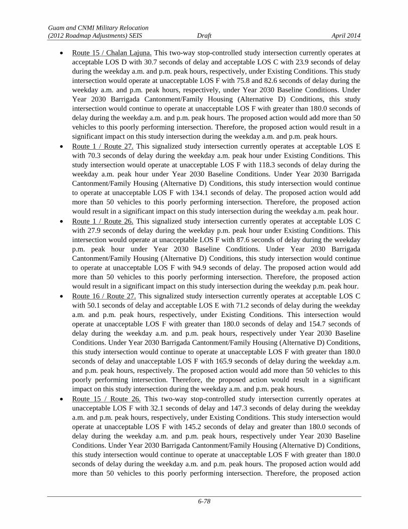
Guam and CNMI Military Relocation
(2012 Roadmap Adjustments) SEIS Draft April 2014
6-78
Route 15 / Chalan Lajuna. This two-way stop-controlled study intersection currently operates at
acceptable LOS D with 30.7 seconds of delay and acceptable LOS C with 23.9 seconds of delay
during the weekday a.m. and p.m. peak hours, respectively, under Existing Conditions. This study
intersection would operate at unacceptable LOS F with 75.8 and 82.6 seconds of delay during the
weekday a.m. and p.m. peak hours, respectively, under Year 2030 Baseline Conditions. Under
Year 2030 Barrigada Cantonment/Family Housing (Alternative D) Conditions, this study
intersection would continue to operate at unacceptable LOS F with greater than 180.0 seconds of
delay during the weekday a.m. and p.m. peak hours. The proposed action would add more than 50
vehicles to this poorly performing intersection. Therefore, the proposed action would result in a
significant impact on this study intersection during the weekday a.m. and p.m. peak hours.
Route 1 / Route 27. This signalized study intersection currently operates at acceptable LOS E
with 70.3 seconds of delay during the weekday a.m. peak hour under Existing Conditions. This
study intersection would operate at unacceptable LOS F with 118.3 seconds of delay during the
weekday a.m. peak hour under Year 2030 Baseline Conditions. Under Year 2030 Barrigada
Cantonment/Family Housing (Alternative D) Conditions, this study intersection would continue
to operate at unacceptable LOS F with 134.1 seconds of delay. The proposed action would add
more than 50 vehicles to this poorly performing intersection. Therefore, the proposed action
would result in a significant impact on this study intersection during the weekday a.m. peak hour.
Route 1 / Route 26. This signalized study intersection currently operates at acceptable LOS C
with 27.9 seconds of delay during the weekday p.m. peak hour under Existing Conditions. This
intersection would operate at unacceptable LOS F with 87.6 seconds of delay during the weekday
p.m. peak hour under Year 2030 Baseline Conditions. Under Year 2030 Barrigada
Cantonment/Family Housing (Alternative D) Conditions, this study intersection would continue
to operate at unacceptable LOS F with 94.9 seconds of delay. The proposed action would add
more than 50 vehicles to this poorly performing intersection. Therefore, the proposed action
would result in a significant impact on this study intersection during the weekday p.m. peak hour.
Route 16 / Route 27. This signalized study intersection currently operates at acceptable LOS C
with 50.1 seconds of delay and acceptable LOS E with 71.2 seconds of delay during the weekday
a.m. and p.m. peak hours, respectively, under Existing Conditions. This intersection would
operate at unacceptable LOS F with greater than 180.0 seconds of delay and 154.7 seconds of
delay during the weekday a.m. and p.m. peak hours, respectively under Year 2030 Baseline
Conditions. Under Year 2030 Barrigada Cantonment/Family Housing (Alternative D) Conditions,
this study intersection would continue to operate at unacceptable LOS F with greater than 180.0
seconds of delay and unacceptable LOS F with 165.9 seconds of delay during the weekday a.m.
and p.m. peak hours, respectively. The proposed action would add more than 50 vehicles to this
poorly performing intersection. Therefore, the proposed action would result in a significant
impact on this study intersection during the weekday a.m. and p.m. peak hours.
Route 15 / Route 26. This two-way stop-controlled study intersection currently operates at
unacceptable LOS F with 32.1 seconds of delay and 147.3 seconds of delay during the weekday
a.m. and p.m. peak hours, respectively, under Existing Conditions. This study intersection would
operate at unacceptable LOS F with 145.2 seconds of delay and greater than 180.0 seconds of
delay during the weekday a.m. and p.m. peak hours, respectively under Year 2030 Baseline
Conditions. Under Year 2030 Barrigada Cantonment/Family Housing (Alternative D) Conditions,
this study intersection would continue to operate at unacceptable LOS F with greater than 180.0
seconds of delay during the weekday a.m. and p.m. peak hours. The proposed action would add
more than 50 vehicles to this poorly performing intersection. Therefore, the proposed action

Guam and CNMI Military Relocation
(2012 Roadmap Adjustments) SEIS Draft April 2014
6-79
would result in a significant impact on this study intersection during the weekday a.m. and p.m.
peak hours.
Route 1 / Route 10A. This signalized study intersection currently operates at acceptable LOS E
with 62.6 seconds of delay during the weekday p.m. peak hour under Existing Conditions. This
study intersection would operate at unacceptable LOS F with 139.3 seconds of delay during the
weekday p.m. peak hour under Year 2030 Baseline Conditions. Under Year 2030 Barrigada
Cantonment/Family Housing (Alternative D) Conditions, this study intersection would continue
to operate at unacceptable LOS F with 143.2 seconds of delay. The proposed action would add
more than 50 vehicles to this poorly performing intersection. Therefore, the proposed action
would result in a significant impact on this study intersection during the weekday p.m. peak hour.
Route 8 / Chalan Santo Papa. This two-way stop-controlled study intersection currently operates
at unacceptable LOS F with 55.1 seconds of delay and 53.0 seconds of delay during the weekday
a.m. and p.m. peak hours, respectively, under Existing Conditions. This study intersection would
continue to operate at unacceptable LOS F with 86.5 seconds of delay and 158.9 seconds of delay
during the weekday a.m. and p.m. peak hours, respectively under Year 2030 Baseline Conditions.
Under Year 2030 Barrigada Cantonment/Family Housing (Alternative D) Conditions, this study
intersection would continue to operate at unacceptable LOS F with 127.7 seconds of delay and
greater than 180.0 seconds of delay during the weekday a.m. and p.m. peak hours, respectively.
The proposed action would add more than 50 vehicles to this poorly performing intersection.
Therefore, the proposed action would result in a significant impact on this study intersection
during the weekday a.m. and p.m. peak hours.
Route 4 / Route 7B. This signalized study intersection currently operates at acceptable LOS E
with 45.7 seconds of delay during the weekday p.m. peak hour under Existing Conditions. This
study intersection would operate at unacceptable LOS F with 161.3 seconds of delay during the
weekday p.m. peak hour under Year 2030 Baseline Conditions. Under Year 2030 Barrigada
Cantonment/Family Housing (Alternative D) Conditions, this study intersection would continue
to operate at unacceptable LOS F with 171.6 seconds of delay during the weekday p.m. peak
hour. The proposed action would add more than 50 vehicles to this poorly performing
intersection. Therefore, the proposed action would result in a significant impact on this study
intersection during the weekday p.m. peak hour.
Although significant impacts would occur at all locations, potential mitigation measures have not been
identified for any of the impacted roadway segments or intersections. Potential mitigation measures
would be similar in scope and scale to those identified in Section 6.1.2.1. However, the exact details of
the improvements would require further evaluations and technical studies to determine their feasibility.
Potential. The final list of implementable mitigation measures will be dependent on the selected
alternative or combination of alternatives and based on project-level technical studies, to be conducted
after the alternative or combination of alternatives is selected. FHWA will conduct all NEPA
documentation efforts and any associated resource consultations as specific mitigation measures are
proposed.
Transit Conditions. There would be no impacts to transit conditions under Alternative D with
Alternative 1.
Pedestrian and Bicycle Conditions. There would be no impacts to pedestrian and bicycle conditions under
Alternative D with Alternative 1.

Guam and CNMI Military Relocation
(2012 Roadmap Adjustments) SEIS Draft April 2014
6-80
Public Health and Safety
The potential for traffic incidents is the primary health and safety issue with potential for having additive
impacts from implementing a specific cantonment/family housing alternative with a specific LFTRC
alternative. The driving distance between the proposed Barrigada Cantonment/Family Housing
(Alternative D) area and Alternative 1 is approximately 5.8 miles. Vehicles would use Routes 8, 10 and
15 to commute between the Alternative D area and Alternative 1.
One high-crash frequency intersection (intersection of Routes 8/10/16) is situated along the travel route
between the Alternative D area and Alternative 1. This intersection is in the central portion of Guam and
must be driven through when arriving/leaving the Barrigada Main Gate because Route 8 provides direct
access to the Alternative D area. The travel distance between the Alternative D area and Alternative 1 is
relatively short however, with this one high-frequency crash intersection situated along the travel route
resulting in a higher potential for being involved in a traffic incident or to be delayed because of traffic
incidents. Because the travel distance is short, a less-than-significant additive impact on traffic would
occur.
Barrigada Cantonment/Family Housing Alternative D with any NAVMAG LFTRC 6.1.2.8
Alternative (Alternatives 2, 3, or 4)
Air Quality
The combined air quality impacts would be similar to those described in Section 6.1.2.1. The combined
construction island-wide emissions, summarized in Section 6.1.2.7 and Table 6.1.2-28, would be less than
significant as a result of these combined alternatives.
Terrestrial Biological Resources
Barrigada Cantonment/Family Housing Alternative D with NAVMAG (East/West) LFTRC Alternative 2
The additive impacts of implementing Cantonment/Family Housing Alternative D, LFTRC Alternative 2,
and the IT/COMM infrastructure are provided in Table 6.1.2-32. Overall, approximately 316 acres (128
ha) of limestone forest, or 1% of the total limestone forest currently present on Guam, would be disturbed.
In addition, approximately 153 acres (62 ha) of Overlay Refuge lands, or 1% of the total Overlay Refuge
currently present on Guam, would be disturbed. In regards to recovery habitat for ESA-listed species, the
greatest impact would be to Guam rail recovery habitat with 1,042 acres (422 ha) developed, mostly
associated with Alternative D. The proposed IT/COMM alignment contributes little to the overall
potential impact to terrestrial biological resources. Additive impacts to terrestrial biological resources
would be less than significant.
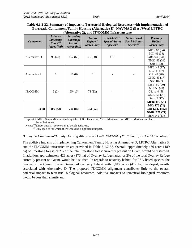
Guam and CNMI Military Relocation
(2012 Roadmap Adjustments) SEIS Draft April 2014
6-81
Table 6.1.2-32. Summary of Impacts to Terrestrial Biological Resources with Implementation of
Barrigada Cantonment/Family Housing (Alternative D), NAVMAG (East/West) LFTRC
(Alternative 2), and IT/COMM Infrastructure
Component
Primary
Limestone
Forest(1)
(acres [ha])
Secondary
Limestone
Forest(1)
(acres [ha])
Overlay
Refuge(1)
(acres [ha])
ESA-Listed
Special-Status
Species(2)
Guam-Listed
Special-Status
Species(2)
Recovery
Habitat
(acres [ha])
Alternative D 99 (40) 167 (68) 75 (30) GR -
MFB: 83 (34)
MC: 83 (34)
GR: 849 (344)
GMK: 83 (34)
Ser: 81 (3)
Alternative 2 0 19 (8) 0 - -
MFB: 43 (17)
MC: 43 (17)
GR: 49 (20)
GMK: 43 (17)
Ser: 18 (7)
IT/COMM 6 (2) 25 (10) 78 (32) - -
MFB: 50 (20)
MC: 50 (20)
GR: 144 (58)
GMK: 50 (20)
Ser: 42 (17)
Total 105 (42) 211 (86) 153 (62) - -
MFB: 176 (71)
MC: 176 (71)
GR: 1,042 (422)
GMK: 176 (71)
Ser: 141 (57)
Legend: GMK = Guam Micronesian kingfisher, GR = Guam rail, MC = Mariana crow, MFB = Mariana fruit bat,
Ser = Serianthes.
Notes: (1) Direct impact - conversion to developed areas. (2) Only species for which there would be a significant impact.
Barrigada Cantonment/Family Housing Alternative D with NAVMAG (North/South) LFTRC Alternative 3
The additive impacts of implementing Cantonment/Family Housing Alternative D, LFTRC Alternative 3,
and the IT/COMM infrastructure are provided in Table 6.1.2-33. Overall, approximately 466 acres (189
ha) of limestone forest, or 2% of the total limestone forest currently present on Guam, would be disturbed.
In addition, approximately 428 acres (173 ha) of Overlay Refuge lands, or 2% of the total Overlay Refuge
currently present on Guam, would be disturbed. In regards to recovery habitat for ESA-listed species, the
greatest impact would be to Guam rail recovery habitat with 1,017 acres (412 ha) developed, mostly
associated with Alternative D. The proposed IT/COMM alignment contributes little to the overall
potential impact to terrestrial biological resources. Additive impacts to terrestrial biological resources
would be less than significant.
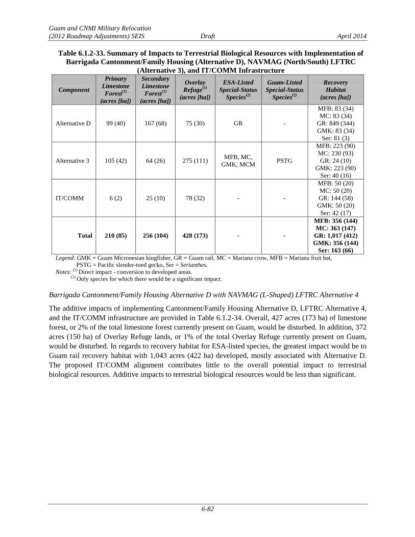
Guam and CNMI Military Relocation
(2012 Roadmap Adjustments) SEIS Draft April 2014
6-82
Table 6.1.2-33. Summary of Impacts to Terrestrial Biological Resources with Implementation of
Barrigada Cantonment/Family Housing (Alternative D), NAVMAG (North/South) LFTRC
(Alternative 3), and IT/COMM Infrastructure
Component
Primary
Limestone
Forest(1)
(acres [ha])
Secondary
Limestone
Forest(1)
(acres [ha])
Overlay
Refuge(1)
(acres [ha])
ESA-Listed
Special-Status
Species(2)
Guam-Listed
Special-Status
Species(2)
Recovery
Habitat
(acres [ha])
Alternative D 99 (40) 167 (68) 75 (30) GR -
MFB: 83 (34)
MC: 83 (34)
GR: 849 (344)
GMK: 83 (34)
Ser: 81 (3)
Alternative 3 105 (42) 64 (26) 275 (111) MFB, MC,
GMK, MCM PSTG
MFB: 223 (90)
MC: 230 (93)
GR: 24 (10)
GMK: 223 (90)
Ser: 40 (16)
IT/COMM 6 (2) 25 (10) 78 (32) - -
MFB: 50 (20)
MC: 50 (20)
GR: 144 (58)
GMK: 50 (20)
Ser: 42 (17)
Total 210 (85) 256 (104) 428 (173) - -
MFB: 356 (144)
MC: 363 (147)
GR: 1,017 (412)
GMK: 356 (144)
Ser: 163 (66)
Legend: GMK = Guam Micronesian kingfisher, GR = Guam rail, MC = Mariana crow, MFB = Mariana fruit bat,
PSTG = Pacific slender-toed gecko, Ser = Serianthes.
Notes: (1) Direct impact - conversion to developed areas. (2) Only species for which there would be a significant impact.
Barrigada Cantonment/Family Housing Alternative D with NAVMAG (L-Shaped) LFTRC Alternative 4
The additive impacts of implementing Cantonment/Family Housing Alternative D, LFTRC Alternative 4,
and the IT/COMM infrastructure are provided in Table 6.1.2-34. Overall, 427 acres (173 ha) of limestone
forest, or 2% of the total limestone forest currently present on Guam, would be disturbed. In addition, 372
acres (150 ha) of Overlay Refuge lands, or 1% of the total Overlay Refuge currently present on Guam,
would be disturbed. In regards to recovery habitat for ESA-listed species, the greatest impact would be to
Guam rail recovery habitat with 1,043 acres (422 ha) developed, mostly associated with Alternative D.
The proposed IT/COMM alignment contributes little to the overall potential impact to terrestrial
biological resources. Additive impacts to terrestrial biological resources would be less than significant.
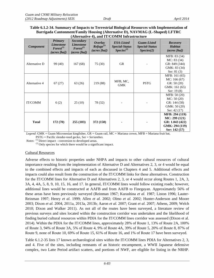
Guam and CNMI Military Relocation
(2012 Roadmap Adjustments) SEIS Draft April 2014
6-83
Table 6.1.2-34. Summary of Impacts to Terrestrial Biological Resources with Implementation of
Barrigada Cantonment/Family Housing (Alternative D), NAVMAG (L-Shaped) LFTRC
(Alternative 4), and IT/COMM Infrastructure
Component
Primary
Limestone
Forest(1)
(acres [ha])
Secondary
Limestone
Forest(1)
(acres [ha])
Overlay
Refuge(1)
(acres [ha])
ESA-Listed
Special-Status
Species(2)
Guam-Listed
Special-Status
Species(2)
Recovery
Habitat
(acres [ha])
Alternative D 99 (40) 167 (68) 75 (30) GR -
MFB: 83 (34)
MC: 83 (34)
GR: 849 (344)
GMK: 83 (34)
Ser: 81 (3)
Alternative 4 67 (27) 63 (26) 219 (88) MFB, MC,
GMK PSTG
MFB: 161 (65)
MC: 166 (67)
GR: 50 (20)
GMK: 161 (65)
Ser: 19 (8)
IT/COMM 6 (2) 25 (10) 78 (32) - -
MFB: 50 (20)
MC: 50 (20)
GR: 144 (58)
GMK: 50 (20)
Ser: 42 (17)
Total 172 (70) 255 (103) 372 (150) - -
MFB: 294 (119)
MC: 299 (121)
GR: 1.043 (422)
GMK: 294 (119)
Ser: 142 (57)
Legend: GMK = Guam Micronesian kingfisher, GR = Guam rail, MC = Mariana crown, MFB = Mariana fruit bat,
PSTG = Pacific slender-toed gecko, Ser = Serianthes.
Notes: (1) Direct impact - conversion to developed areas.
(2) Only species for which there would be a significant impact.
Cultural Resources
Adverse effects to historic properties under NHPA and impacts to other cultural resources of cultural
importance resulting from the implementation of Alternative D and Alternatives 2, 3, or 4 would be equal
to the combined effects and impacts of each as discussed in Chapters 4 and 5. Additional effects and
impacts could also result from the construction of the IT/COMM links for these alternatives. Construction
for the IT/COMM lines for Alternative D and Alternatives 2, 3, or 4 would occur along Routes 1, 2A, 3,
3A, 4, 4A, 5, 8, 9, 10, 15, 16, and 17. In general, IT/COMM lines would follow existing roads; however,
additional lines would be constructed at AAFB and from AAFB to Finegayan. Approximately 56% of
these areas have been previously surveyed (Reinman 1967; Kurashina et al. 1987; Liston 1996; Lauter-
Reinman 1997; Henry et al. 1999; Allen et al. 2002; Olmo et al. 2002; Hunter-Anderson and Moore
2003; Dixon et al. 2004, 2011a, 2013a, 2013b; Aaron et al. 2007; Grant et al. 2007; Athens, 2009; Welch
2010; Dixon and Walker 2011). As not all of the routes have been surveyed, a literature review of
previous surveys and sites located within the construction corridor was undertaken and the likelihood of
finding buried cultural resources within PDIA for the IT/COMM lines corridor was assessed (Dixon et al.
2014). Within the PDIA for the IT/COMM lines, approximately 28% of Route 1, 13% of Route 2A, 100%
of Route 3, 94% of Route 3A, 5% of Route 4, 9% of Route 4A, 39% of Route 5, 20% of Route 8, 87% of
Route 9, none of Route 10, 69% of Route 15, 61% of Route 16, and 1% of Route 17 have been surveyed.
Table 6.1.2-35 lists 17 known archaeological sites within the IT/COMM lines PDIA for Alternatives 2, 3,
and 4. Five of the sites, including remnants of an historic encampment, a WWII Japanese defensive
complex, two Latte Period artifact scatters, and portions of NWF, are eligible for listing in the NRHP.

Guam and CNMI Military Relocation
(2012 Roadmap Adjustments) SEIS Draft April 2014
6-84
Twelve archaeological sites are not eligible for listing in the NRHP. There is also a potential for buried
cultural resources along Routes 1, 5, 15, and 17 within unsurveyed areas.
Table 6.1.2-35. Archaeological Sites within IT/COMM Lines Potential Impacted area for Barrigada
Cantonment/Family Housing (Alternative D) and LFTRC Alternatives 2, 3, or 4
GHPI
Number†
Temporary
Site
Number/Map
Number*
Site Type Period Reference NRHP
Eligible?
NRHP
Criteria
36* Flagpole WWII/Second American
Administration Territorial
Lauter-Reinman
1997 No NA
235* Barracks
remnants
Second American
Administration Territorial Welch et al. 2009 No NA
377* Ceramic Scatter Pre-Contact/Latte Kurashina et al.
1987 No NA
1066*
Marianas-
Bonins base
command area
WWII American Military,
Second American
Administration Territorial
Welch 2010 No NA
66-02-1657 493*
Japanese
defensive
complex
WWII Japanese Military Allen et al. 2002 Yes D
66-02-2644 T-AP-002
Remains of
medical supply
storehouse no.
13
Second American
Administration Territorial Dixon et al. 2014 No NA
66-07-2119 Artifact Scatter Pre-Contact/Latte Welch 2010 No NA
66-07-2124 Bottle Dump WWII, Second American
Administration Territorial Welch 2010 No NA
66-07-2127 Artifact Scatter Pre-Contact/Latte Welch 2010 No NA
66-07-2128 Concrete pad WWII, Second American
Administration Territorial Grant et al. 2007 No NA
66-07-2321 Ceramic/
Artifact Scatter Pre-Contact/Latte Welch 2010 Yes D
66-08-1065 NWF Second American
Administration Territorial Aaron et al. 2007 Yes A
66-08-2305 Encampment Second American
Administration Territorial Welch 2010 Yes D
66-08-2308 Artifact Scatter Pre-Contact/Latte Welch 2010 Yes D
T-A4S-5 Concrete Pads WWII, Second American
Administration Territorial
Dixon and Walker
2011 No NA
T-H-1
Artifact Scatter
& Concrete
Foundations
WWII, Second American
Administration Territorial
Dixon and Walker
2011 No NA
T-WAW-016 Bottle scatter
Pre-Contact/Latte;
Japanese Administration,
Second American
Administration Territorial
Dixon et al. 2014 No NA
Legend: GHPI = Guam Historic Properties Inventory; NRHP = National Register of Historic Places; NA=not applicable; NRHP
criterion A = eligible because they are associated with events that have made a significant contribution to the broad pattern
of history, criterion D = eligible for potential to yield information important in prehistory or history.
Notes: †Not all sites recorded within the project areas have received official GHPI numbers, although they have been documented
as part of previous surveys.
*From Welch (2009) (Map no. 36, 235, 377, 493) and Welch (2010) (Map no. 1066).

Guam and CNMI Military Relocation
(2012 Roadmap Adjustments) SEIS Draft April 2014
6-85
One structure eligible for listing in the NRHP, North Field, is located within the potential impacted area
for Alternatives 2, 3, and 4. No TCPs have been identified in the potential impacted areas for the
IT/COMM lines.
The installation of IT/COMM links between Alternative D and the LFTRC Alternatives 2, 3, or 4 has the
potential to result in adverse effects from excavation and soil removal to six historic properties—five
NRHP-eligible archaeological sites (see Table 6.1.2-35) and one NRHP-eligible structure (North Field),
as well as undetermined effects to possible buried cultural resources in unsurveyed areas along Routes 1,
5, 15, and 17. Based on an examination of previous investigations and predictive modeling, there is a low
potential for NRHP-eligible sites in the remaining areas. No TCPs would be directly affected by the
construction of the IT/COMM links.
No direct or indirect adverse effects due to operation of the IT/COMM utilities would occur as these lines
would be buried and there would be no change in use, and no effects to the setting.
The 2011 PA, as discussed in Section 3.10.2, establishes a program alternative for complying with NHPA
Section 106 requirements. To the degree possible, impacts to historic properties and other resources of
cultural importance would be avoided during the planning process. Consultation under the 2011 PA will
address potential adverse effects and alternatives to avoid adverse effects. If avoidance is not possible,
potential minimization and mitigation measures may include data recovery and monitoring during
construction in areas with likelihood for buried cultural resources. However, final mitigation will be
determined after completion of the consultation process outlined in the PA. With the implementation of
these measures and processes as outlined in the 2011 PA, additive impacts associated with IT/COMM
would be reduced to a level below significance.
Ground Transportation
Alternative D was modeled with Alternative 5 (Section 3.12.1). Pairing Alternative D with Alternative 2,
3, or 4 may result in a slight increase (less than 5%) in vehicles on roadway segments and at intersections
that comprise the most direct route between the Alternative D Main Gate and the Alternative 2, 3, or 4
gates, as well as a slight decrease in vehicles on roadway segments and at intersections that comprise the
most direct route between the modeled combination Alternative D Main Gate and the Alternative 5 gate
(see Figure 6.1.2-4). This minimal incremental increase or decrease in traffic volumes would not
adversely affect level of service on roadways or at intersections along the route.
Although significant impacts would occur at all locations, potential mitigation measures have not been
identified for any of the impacted roadway segments or intersections. Potential mitigation measures
would be similar in scope and scale to those identified in Section 6.1.2.1. However, the exact details of
the improvements would require further evaluations and technical studies to determine their feasibility.
The final list of implementable mitigation measures will be dependent on the selected alternative, or
combination of alternatives and based on project-level technical studies to be conducted after the
alternative or combination of alternatives is selected. FHWA will conduct all NEPA documentation
efforts and any associated resource consultations as specific mitigation measures are proposed.
Roadway Segment Operations. Impacts to all off-base (external) roadway segments would be the same as
those identified in Section 6.1.2.7. Significant impacts were identified on twelve roadway segments. The
detailed results of the roadway segment analysis are provided in their entirety in Appendix F.

Guam and CNMI Military Relocation
(2012 Roadmap Adjustments) SEIS Draft April 2014
6-86
Intersection Operations. Impacts to all intersections would be the same as those identified in Section
6.1.2.7 (see Table 6.1.2-31). Significant impacts were identified at eight intersections. The detailed results
of the intersection analysis are provided in its entirety in Appendix F.
Transit Conditions. Transit conditions under Alternative D with Alternative 2, 3, or 4 would be similar to
those described in Section 6.1.2.7 for Alternative D with Alternative 1.
Pedestrian and Bicycle Conditions. Pedestrian and bicycle conditions under Alternative D with
Alternative 2, 3, or 4 would be similar to those described in Section 6.1.2.7 for Alternative D with
Alternative 1.
Public Health and Safety
The potential for traffic incidents is the primary health and safety issue with potential for having additive
impacts from implementing a specific cantonment/family housing alternative with a specific LFTRC
alternative. The driving distance between the Alternative D area and Alternatives 2, 3, and 4 is
approximately 17.7 miles to Alternative 2, and approximately 17.0 miles to Alternatives 3 and 4. Vehicles
would use Routes 1, 8, and 10 to commute between the Alternative D area and Alternative 2, while
Routes 4, 8, and 10, as well as a new roadway in Dandan, would be used to access Alternatives 3 and 4.
One high-crash frequency intersection (intersection of Routes 8/10/16) is situated along the travel route
between the Alternative D area and Alternatives 2, 3, and 4. This intersection is in the central portion of
Guam, and because Route 8 provides direct access to the Alternative D area, this intersection must be
driven through when arriving/leaving the Barrigada Main Gate. The travel distance between the
Alternative D area and Alternatives 2, 3, and 4 is relatively long, with one high-frequency crash
intersection situated along the travel route, resulting in a higher potential for being involved in a traffic
incident or to be delayed because of traffic incidents. However, a less-than-significant additive impact on
traffic would occur.
Barrigada Cantonment/Family Housing Alternative D with NWF LFTRC Alternative 5 6.1.2.9
Air Quality
The combined air quality impacts would be similar to those described in Section 6.1.2.1.
The combined construction island-wide emissions, summarized in Section 6.1.2.7 and Table 6.1.2-28,
would be less than significant as a result of these combined alternatives.
Terrestrial Biological Resources
The additive impacts of implementing Cantonment/Family Housing Alternative D, LFTRC Alternative 5,
and the IT/COMM infrastructure are provided in Table 6.1.2-36. Overall, 498 acres (202 ha) of limestone
forest, or 2% of the total limestone forest currently present on Guam, would be disturbed. In addition, 407
acres (165 ha) of Overlay Refuge lands, or 2% of the total Overlay Refuge currently present on Guam,
would be disturbed. In regards to recovery habitat for ESA-listed species, the greatest impact would be to
Guam rail recovery habitat with 1,033 acres (418 ha) developed, mostly associated with Alternative D.
The proposed IT/COMM alignment contributes little to the overall potential impact to terrestrial
biological resources. Additive impacts to terrestrial biological resources would be less than significant.

Guam and CNMI Military Relocation
(2012 Roadmap Adjustments) SEIS Draft April 2014
6-87
Table 6.1.2-36. Summary of Impacts to Terrestrial Biological Resources with Implementation of
Barrigada Cantonment/Family Housing (Alternative D), NWF LFTRC (Alternative 5),
and IT/COMM Infrastructure
Component
Primary
Limestone
Forest(1)
(acres [ha])
Secondary
Limestone
Forest(1)
(acres [ha])
Overlay
Refuge(1)
(acres [ha])
ESA-Listed
Special-Status
Species(2)
Guam-Listed
Special-Status
Species(2)
Recovery
Habitat
(acres [ha])
Critical
Habitat
(acres [ha])
Alternative D 99 (40) 167 (68) 75 (30) GR -
MFB: 83 (34)
MC: 83 (34)
GR: 849 (344)
GMK: 83 (34)
Ser: 81 (3)
NA
Alternative 5 90 (37) 111 (45) 254 (103) MFB, MC,
GMK, Ser -
MFB: 196 (79)
MC: 196 (79)
GR: 40 (16)
GMK: 196 (79)
Ser: 154 (62)
MFB, MC,
GMK: 12 (5)
IT/COMM 6 (2) 25 (10) 78 (32) - -
MFB: 50 (20)
MC: 50 (20)
GR: 144 (58)
GMK: 50 (20)
Ser: 42 (17)
NA
Total 195 (79) 303 (123) 407 (165)
MFB: 329 (133)
MC: 329 (133)
GR: 1.033 (418)
GMK: 329 (133)
Ser: 277 (112)
Legend: GMK = Guam Micronesian kingfisher, GR = Guam rail, MC = Mariana crown, MFB = Mariana fruit bat, Ser = Serianthes.
Notes:(1)
Direct impact - conversion to developed areas. (2)
Only species for which there would be a significant impact.
Cultural Resources
Adverse effects to historic properties under NHPA and impacts to other cultural resources of cultural
importance resulting from the implementation of Alternatives D and 5 would be equal to the combined
effects and impacts of each as discussed in Chapters 4 and 5. Additional effects and impacts could also
result from the construction of the IT/COMM links for these alternatives. Construction for the IT/COMM
lines for Alternative D and Alternative 5 would occur along Routes 1, 3, 3A, 4, 5, 8, 9, 10, 15, 16, and 17.
In general, IT/COMM lines would follow existing roads; however, additional lines would be constructed
at AAFB and from AAFB to Finegayan. Approximately 56% of these areas have been previously
surveyed (Reinman 1967; Kurashina et al. 1987; Liston 1996; Lauter-Reinman 1997; Hunter-Anderson
and Moore 2003; Dixon et al. 2004, 2011a, 2013a, 2013b; Aaron et al. 2007; Grant et al. 2007; Athens,
2009; Welch 2010; Dixon and Walker 2011). As not all of the routes have been surveyed, a literature
review of previous surveys and sites located within the construction corridor was undertaken and the
likelihood of finding buried cultural resources within PDIA for the IT/COMM lines corridor was assessed
(Dixon et al. 2014). Within the PDIA for the IT/COMM lines, approximately 15% of Route 1, 100% of
Route 3, 62% of Route 3A, 1% of Route 4, 39% of Route 5, 5% of Route 8, 87% of Route 9, none of
Route 10, 69% of Route 15, 61% of Route 16, and 1% of Route 17 have been surveyed.
Table 6.1.2-37 lists 17 known archaeological sites within the IT/COMM lines PDIA. Five of the sites,
including two Latte Period artifact scatters, an historic encampment, a WWII Japanese defensive
complex, and portions of NWF, are eligible to the NRHP. Twelve archaeological sites are not eligible for

Guam and CNMI Military Relocation
(2012 Roadmap Adjustments) SEIS Draft April 2014
6-88
listing in the NRHP. There is also a potential for buried cultural resources along Routes 1, 5, 15, and 17
within unsurveyed areas.
Table 6.1.2-37. Archaeological Sites within the IT/COMM Lines Potential Impacted Area for
Barrigada Cantonment Housing (Alternative D) and the NWF LFTRC (Alternative 5)
GHPI
Number†
Temporary
Site
Number/Map
Number*
Site Type Period Reference NRHP
Eligible?
NRHP
Criteria
36* Flagpole stand WWII/Second American
Administration Territorial
Lauter-
Reinman 1997 No NA
377* Ceramic Scatter Pre-Contact/Latte Kurashina et al.
1987 No NA
1066*
MARBO base
command area
remnants –
concrete pads,
roads, other
remains
WWII American Military,
Second American
Administration Territorial
Welch 2010 No NA
66-02-1657 493*
Japanese
defensive
complex
WWII Japanese Military Allen et al.
2002 Yes D
66-02-2644 T-AP-002
Remains of
medical supply
storehouse no. 13
Second American
Administration Territorial
Dixon et al.
2014 No D
66-07-2119 Artifact scatter Pre-Contact/Latte Welch 2010 No NA
66-07-2124 Bottle dump WWII, Second American
Administration Territorial Welch 2010 No NA
66-07-2127 Artifact scatter Pre-Contact/Latte Welch 2010 No NA
66-07-2128 Concrete pad WWII, Second American
Administration Territorial
Grant et al.
2007 No NA
66-07-2321 Ceramic/
artifact scatter Pre-Contact/Latte Welch 2010 Yes D
66-08-1065 NWF Second American
Administration Territorial
Aaron et al.
2007 Yes A
66-08-2305 Encampment Second American
Administration Territorial Welch 2010 Yes D
66-08-2308 Artifact Scatter Pre-Contact/Latte Welch 2010 Yes D
T-A4S-5 Concrete pads WWII, Second American
Administration Territorial
Dixon and
Walker 2011 No NA
T-H-1
Artifact scatter &
concrete
foundations
WWII, Second American
Administration Territorial
Dixon and
Walker 2011 No NA
T-H20-1
Water catchment
with pump
generator & fuel
tank foundations
WWII, Second American
Administration Territorial
Dixon and
Walker 2011 No NA
T-WAW-016 Bottle scatter
Pre-Contact/Latte, Japanese
Administration, Second
American Administration
Territorial
Dixon et al.
2014 No NA
Legend: GHPI = Guam Historic Properties Inventory; NRHP = National Register of Historic Places; NA=not applicable; NRHP
criterion A = eligible because they are associated with events that have made a significant contribution to the broad pattern
of history.
Notes: †Not all sites recorded within the project areas have received official GHPI numbers, although they have been documented
as part of previous surveys.
*From Welch (2009) (Map no. 36, 377, 493) and Welch (2010) (Map no. 1066).

Guam and CNMI Military Relocation
(2012 Roadmap Adjustments) SEIS Draft April 2014
6-89
One structure eligible for listing on the NRHP, North Field, is located within the potential impacted area.
No TCPs have been identified in the potential impacted areas for the IT/COMM lines.
The installation of IT/COMM links between Alternative D and the LFTRC Alternative 5 has the potential
to result in adverse effects from excavation and soil removal to six historic properties—five NRHP-
eligible archaeological sites (see Table 6.1.2-37), and one NRHP-eligible structure (North Field), as well
as undetermined effects to possible buried cultural resources in unsurveyed areas along Routes 1, 5, 15,
and 17. Based on an examination of previous investigations and predictive modeling, there is a low
potential for NRHP-eligible sites in the remaining areas. No TCPs would be directly affected by the
construction of the IT/COMM links.
No direct or indirect adverse effects due to operation of the IT/COMM utilities would occur as these lines
would be buried and there would be no change in use, and no effects to the setting.
The 2011 PA, as discussed in Section 3.10.2, establishes a program alternative for complying with NHPA
Section 106 requirements. To the degree possible, impacts to historic properties and other resources of
cultural importance would be avoided during the planning process. Consultation under the 2011 PA will
address potential adverse effects and alternatives to avoid adverse effects. If avoidance is not possible,
potential minimization and mitigation measures may include data recovery and monitoring during
construction in areas with likelihood for buried cultural resources. However, final mitigation will be
determined after completion of the consultation process outlined in the PA. With the implementation of
these measures and processes as outlined in the 2011 PA, additive impacts associated with IT/COMM
would be reduced to a level below significance.
Ground Transportation
Alternative D was modeled with Alternative 5 (Section 3.12.1). Although significant impacts would occur
at all locations, potential mitigation measures have not been identified for any of the impacted roadway
segments or intersections. Potential mitigation measures would be similar in scope and scale to those
identified in Section 6.1.2.1. However, the exact details of the improvements would require further
evaluations and technical studies to determine their feasibility. The final list of implementable mitigation
measures will be dependent on the selected alternative or combination of alternatives and based on
project-level technical studies, to be conducted after the alternative or combination of alternatives is
selected. FHWA will conduct all NEPA documentation efforts and any associated resource consultations
as specific mitigation measures are proposed.
Roadway Segment Operations. Impacts to all off-base (external) roadway segments would be the same as
those identified in Section 6.1.2.7. Significant impacts were identified on twelve roadway segments. The
detailed results of the roadway segment analysis are provided in their entirety in Appendix F.
Intersection Operations. Impacts to all intersections would be the same as those identified in Section
6.1.2.7 (Table 6.1.2-31). Significant impacts were identified at eight intersections. The detailed results of
the intersection analysis are provided in its entirety in Appendix F.
Transit Conditions. Transit conditions under Alternative D with Alternative 5 would be similar to those
described in Section 6.1.2.7 for Alternative D with Alternative 1.
Pedestrian and Bicycle Conditions. Pedestrian and bicycle conditions under Alternative D with
Alternative 5 would be similar to those described in Section 6.1.2.7 for Alternative D with Alternative 1.

Guam and CNMI Military Relocation
(2012 Roadmap Adjustments) SEIS Draft April 2014
6-90
Public Health and Safety
The potential for traffic incidents is the primary health and safety issue with potential for having additive
impacts from implementing a specific cantonment/family housing alternative with a specific LFTRC
alternative. The driving distance between the Alternative D area and Alternative 5 is approximately 16.9
miles. Vehicles would use Routes 1, 3, 3A, 8, and 16 to commute between the Alternative D area and
Alternative 5.
Two high-crash frequency intersections (intersection of Routes 8/10/16 and Routes 1/3) are situated along
the travel route between the Alternative D area and Alternative 5. In an effort to improve vehicle safety at
the intersection of Routes 8/10/16, traffic improvements were completed in 2012 that includes the
installation of a new traffic signal system that reduced congestion and channelized traffic. These
intersections are in the central portion of Guam and because Route 8 provides direct access to the
Alternative D area, that intersection must be driven through when arriving/leaving the Barrigada Main
Gate. The travel distance between the Alternative D area and Alternative 5 is relatively long, with the two
high-frequency crash intersections situated along the travel route resulting in a higher potential for being
involved in a traffic incident or to be delayed because of traffic incidents. However, a less-than-
significant additive impact on traffic would occur.
6.1.3 Summary of Additive Impacts
Table 6.1.3-1 summarizes the additive impacts to the resources that would be impacted by unique site
combinations, as discussed in Section 6.1.2.

Guam and CNMI Military Relocation
(2012 Roadmap Adjustments) SEIS Draft April 2014
Legend: SI = significant impact; SI-M = significant impact-mitigable; LSI = less than significant; NI = no impact; BI = beneficial impact.
6-91
Table 6.1.3-1. Summary of Additive Impacts and Potential Mitigation Measures
Finegayan
Alternative A or
B with Route 15
LFTRC
Alternative 1
Finegayan
Alternative A or
B with
NAVMAG
LFTRC
Alternatives 2, 3,
or 4
Finegayan
Alternative A or
B with NWF
LFTRC
Alternative 5
AAFB
Alternative C
with Route 15
LFTRC
Alternative 1
AAFB
Alternative C
with NAVMAG
LFTRC
Alternatives 2,
3, or 4
AAFB
Alternative C
with NWF
LFTRC
Alternative 5
Barrigada
Alternative D
with Route 15
LFTRC
Alternative 1
Barrigada
Alternative D with
NAVMAG
LFTRC
Alternatives 2, 3,
or 4
Barrigada
Alternative D
with NWF
LFTRC
Alternative 5
GEOLOGICAL AND SOIL RESOURCES
LSI
Direct, short-term construction impacts along any of the IT/COMM routes. Earthmoving activities would occur mostly in roadways or other previously disturbed areas. BMPs would
be utilized to minimize erosion.
WATER RESOURCES
LSI IT/COMM construction would increase potential for short-term increases in stormwater runoff and erosion. The size and nature of the potentially disturbed area would vary
marginally depending on the IT/COMM route, and some routes are closer to surface waters and wetlands than others. However, through compliance with the Construction General
Permit and Program SWPPP and implementation of a site-specific SWPPPs, and associated erosion control, runoff reduction, and sediment removal BMPs, impacts to surface water
resources would be minimized and off-site transport of stormwater runoff would be unlikely except during extreme weather events (i.e., typhoons). These stormwater runoff
protection measures would also serve to protect surface water, groundwater, and wetlands from indirect impacts and prevent impacts to nearshore waters. Because the IT/COMM
lines would primarily be located in existing roadways, no direct impacts to wetlands or other waters of the U.S. are anticipated. The potential exposure to direct or indirect impacts at
any one location or resource would be short-term, given that construction would not occur simultaneously along the entire IT/COMM route at any one time and construction at any
one location would be of relatively short duration. Based on these considerations, the additive impacts of IT/COMM construction activities would be less than significant.
AIR QUALITY
LSI
Hot-spot
concentrations for
mobile source
CO, PM, and
MSATs would be
below standards.
Construction
emissions would
be below the
significance
criterion for all
combinations.
Alternative A
combination
would be outside
SO2
nonattainment
areas, so no
additive impacts
with respect to
LSI Impacts would be
the same as
described for
Alternatives A or
B with
Alternative 1.
LSI Impacts would be
the same as
described for
Alternatives A or
B with
Alternative 1.
LSI Hot-spot
concentration
results would be
the same as
described for
Alternatives A or
B with
Alternative 1.
Construction
emissions would
be marginally
different than for
Alternative A or
B combinations
with Alternative
1 but would also
be below
pollutant
thresholds. This
combination
LSI Impacts would
be the same as
described for
Alternative C
with Alternative
1.
LSI Impacts would
be the same as
described for
Alternative C
with
Alternative 1.
LSI Hot-spot
concentration
results would be
the same as
described for
Alternatives A or
B with
Alternative 1.
Construction
emissions would
be marginally
different than for
Alternative A, B,
or C
combinations
with Alternative
1 but would also
be below
pollutant
thresholds. This
LSI Impacts would be
the same as
described for
Alternative D with
Alternative 1.
LSI Impacts would
be the same as
described for
Alternative D
with
Alternative 1.
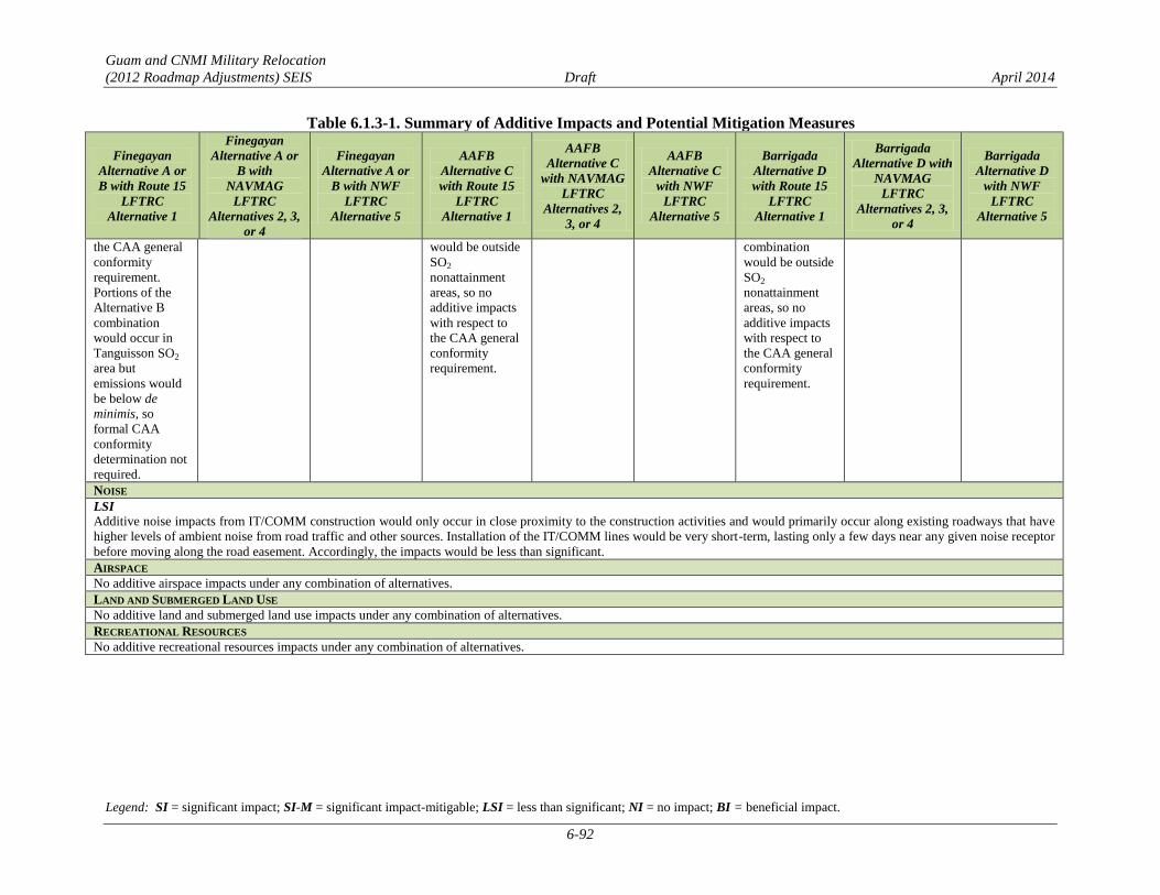
Guam and CNMI Military Relocation
(2012 Roadmap Adjustments) SEIS Draft April 2014
Legend: SI = significant impact; SI-M = significant impact-mitigable; LSI = less than significant; NI = no impact; BI = beneficial impact.
6-92
Table 6.1.3-1. Summary of Additive Impacts and Potential Mitigation Measures
Finegayan
Alternative A or
B with Route 15
LFTRC
Alternative 1
Finegayan
Alternative A or
B with
NAVMAG
LFTRC
Alternatives 2, 3,
or 4
Finegayan
Alternative A or
B with NWF
LFTRC
Alternative 5
AAFB
Alternative C
with Route 15
LFTRC
Alternative 1
AAFB
Alternative C
with NAVMAG
LFTRC
Alternatives 2,
3, or 4
AAFB
Alternative C
with NWF
LFTRC
Alternative 5
Barrigada
Alternative D
with Route 15
LFTRC
Alternative 1
Barrigada
Alternative D with
NAVMAG
LFTRC
Alternatives 2, 3,
or 4
Barrigada
Alternative D
with NWF
LFTRC
Alternative 5
the CAA general
conformity
requirement.
Portions of the
Alternative B
combination
would occur in
Tanguisson SO2
area but
emissions would
be below de
minimis, so
formal CAA
conformity
determination not
required.
would be outside
SO2
nonattainment
areas, so no
additive impacts
with respect to
the CAA general
conformity
requirement.
combination
would be outside
SO2
nonattainment
areas, so no
additive impacts
with respect to
the CAA general
conformity
requirement.
NOISE
LSI
Additive noise impacts from IT/COMM construction would only occur in close proximity to the construction activities and would primarily occur along existing roadways that have
higher levels of ambient noise from road traffic and other sources. Installation of the IT/COMM lines would be very short-term, lasting only a few days near any given noise receptor
before moving along the road easement. Accordingly, the impacts would be less than significant.
AIRSPACE
No additive airspace impacts under any combination of alternatives.
LAND AND SUBMERGED LAND USE
No additive land and submerged land use impacts under any combination of alternatives.
RECREATIONAL RESOURCES
No additive recreational resources impacts under any combination of alternatives.
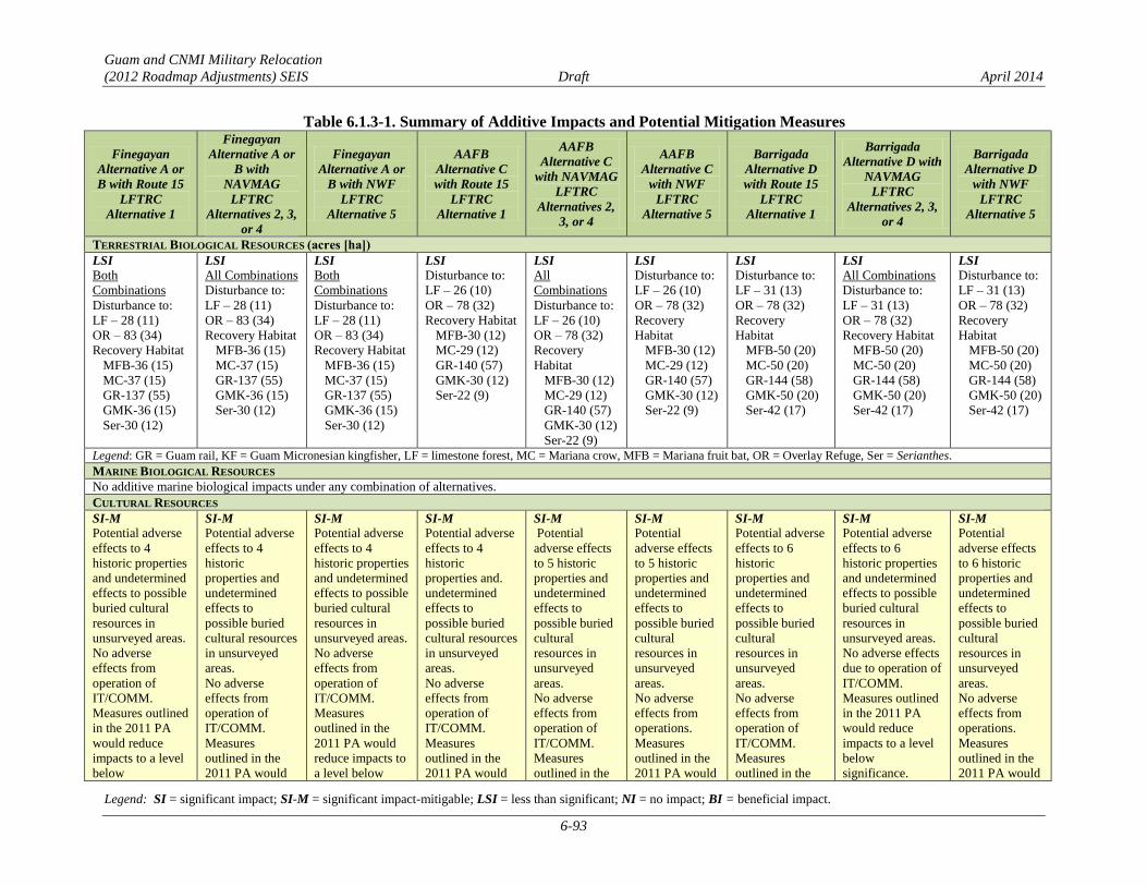
Guam and CNMI Military Relocation
(2012 Roadmap Adjustments) SEIS Draft April 2014
Legend: SI = significant impact; SI-M = significant impact-mitigable; LSI = less than significant; NI = no impact; BI = beneficial impact.
6-93
Table 6.1.3-1. Summary of Additive Impacts and Potential Mitigation Measures
Finegayan
Alternative A or
B with Route 15
LFTRC
Alternative 1
Finegayan
Alternative A or
B with
NAVMAG
LFTRC
Alternatives 2, 3,
or 4
Finegayan
Alternative A or
B with NWF
LFTRC
Alternative 5
AAFB
Alternative C
with Route 15
LFTRC
Alternative 1
AAFB
Alternative C
with NAVMAG
LFTRC
Alternatives 2,
3, or 4
AAFB
Alternative C
with NWF
LFTRC
Alternative 5
Barrigada
Alternative D
with Route 15
LFTRC
Alternative 1
Barrigada
Alternative D with
NAVMAG
LFTRC
Alternatives 2, 3,
or 4
Barrigada
Alternative D
with NWF
LFTRC
Alternative 5
TERRESTRIAL BIOLOGICAL RESOURCES (acres [ha])
LSI
Both
Combinations
Disturbance to:
LF – 28 (11)
OR – 83 (34)
Recovery Habitat
MFB-36 (15)
MC-37 (15)
GR-137 (55)
GMK-36 (15)
Ser-30 (12)
LSI
All Combinations
Disturbance to:
LF – 28 (11)
OR – 83 (34)
Recovery Habitat
MFB-36 (15)
MC-37 (15)
GR-137 (55)
GMK-36 (15)
Ser-30 (12)
LSI
Both
Combinations
Disturbance to:
LF – 28 (11)
OR – 83 (34)
Recovery Habitat
MFB-36 (15)
MC-37 (15)
GR-137 (55)
GMK-36 (15)
Ser-30 (12)
LSI
Disturbance to:
LF – 26 (10)
OR – 78 (32)
Recovery Habitat
MFB-30 (12)
MC-29 (12)
GR-140 (57)
GMK-30 (12)
Ser-22 (9)
LSI
All
Combinations
Disturbance to:
LF – 26 (10)
OR – 78 (32)
Recovery
Habitat
MFB-30 (12)
MC-29 (12)
GR-140 (57)
GMK-30 (12)
Ser-22 (9)
LSI
Disturbance to:
LF – 26 (10)
OR – 78 (32)
Recovery
Habitat
MFB-30 (12)
MC-29 (12)
GR-140 (57)
GMK-30 (12)
Ser-22 (9)
LSI
Disturbance to:
LF – 31 (13)
OR – 78 (32)
Recovery
Habitat
MFB-50 (20)
MC-50 (20)
GR-144 (58)
GMK-50 (20)
Ser-42 (17)
LSI
All Combinations
Disturbance to:
LF – 31 (13)
OR – 78 (32)
Recovery Habitat
MFB-50 (20)
MC-50 (20)
GR-144 (58)
GMK-50 (20)
Ser-42 (17)
LSI
Disturbance to:
LF – 31 (13)
OR – 78 (32)
Recovery
Habitat
MFB-50 (20)
MC-50 (20)
GR-144 (58)
GMK-50 (20)
Ser-42 (17)
Legend: GR = Guam rail, KF = Guam Micronesian kingfisher, LF = limestone forest, MC = Mariana crow, MFB = Mariana fruit bat, OR = Overlay Refuge, Ser = Serianthes.
MARINE BIOLOGICAL RESOURCES
No additive marine biological impacts under any combination of alternatives.
CULTURAL RESOURCES
SI-M
Potential adverse
effects to 4
historic properties
and undetermined
effects to possible
buried cultural
resources in
unsurveyed areas.
No adverse
effects from
operation of
IT/COMM.
Measures outlined
in the 2011 PA
would reduce
impacts to a level
below
SI-M
Potential adverse
effects to 4
historic
properties and
undetermined
effects to
possible buried
cultural resources
in unsurveyed
areas.
No adverse
effects from
operation of
IT/COMM.
Measures
outlined in the
2011 PA would
SI-M
Potential adverse
effects to 4
historic properties
and undetermined
effects to possible
buried cultural
resources in
unsurveyed areas.
No adverse
effects from
operation of
IT/COMM.
Measures
outlined in the
2011 PA would
reduce impacts to
a level below
SI-M
Potential adverse
effects to 4
historic
properties and.
undetermined
effects to
possible buried
cultural resources
in unsurveyed
areas.
No adverse
effects from
operation of
IT/COMM.
Measures
outlined in the
2011 PA would
SI-M
Potential
adverse effects
to 5 historic
properties and
undetermined
effects to
possible buried
cultural
resources in
unsurveyed
areas.
No adverse
effects from
operation of
IT/COMM.
Measures
outlined in the
SI-M
Potential
adverse effects
to 5 historic
properties and
undetermined
effects to
possible buried
cultural
resources in
unsurveyed
areas.
No adverse
effects from
operations.
Measures
outlined in the
2011 PA would
SI-M
Potential adverse
effects to 6
historic
properties and
undetermined
effects to
possible buried
cultural
resources in
unsurveyed
areas.
No adverse
effects from
operation of
IT/COMM.
Measures
outlined in the
SI-M
Potential adverse
effects to 6
historic properties
and undetermined
effects to possible
buried cultural
resources in
unsurveyed areas.
No adverse effects
due to operation of
IT/COMM.
Measures outlined
in the 2011 PA
would reduce
impacts to a level
below
significance.
SI-M
Potential
adverse effects
to 6 historic
properties and
undetermined
effects to
possible buried
cultural
resources in
unsurveyed
areas.
No adverse
effects from
operations.
Measures
outlined in the
2011 PA would

Guam and CNMI Military Relocation
(2012 Roadmap Adjustments) SEIS Draft April 2014
Legend: SI = significant impact; SI-M = significant impact-mitigable; LSI = less than significant; NI = no impact; BI = beneficial impact.
6-94
Table 6.1.3-1. Summary of Additive Impacts and Potential Mitigation Measures
Finegayan
Alternative A or
B with Route 15
LFTRC
Alternative 1
Finegayan
Alternative A or
B with
NAVMAG
LFTRC
Alternatives 2, 3,
or 4
Finegayan
Alternative A or
B with NWF
LFTRC
Alternative 5
AAFB
Alternative C
with Route 15
LFTRC
Alternative 1
AAFB
Alternative C
with NAVMAG
LFTRC
Alternatives 2,
3, or 4
AAFB
Alternative C
with NWF
LFTRC
Alternative 5
Barrigada
Alternative D
with Route 15
LFTRC
Alternative 1
Barrigada
Alternative D with
NAVMAG
LFTRC
Alternatives 2, 3,
or 4
Barrigada
Alternative D
with NWF
LFTRC
Alternative 5
significance. reduce impacts to
a level below
significance.
significance. reduce impacts to
a level below
significance.
2011 PA would
reduce impacts
to a level below
significance.
reduce impacts
to a level below
significance.
2011 PA would
reduce impacts
to a level below
significance.
reduce impacts
to a level below
significance.
VISUAL RESOURCES
No additive visual resources impacts under any combination of alternatives.
GROUND TRANSPORTATION
SI-M
Alternative A/
Alternative 1
Slight increase in
traffic on
segments and
intersections
between
cantonment/
family housing
and LFTRC.
Significant
impacts on 8
segments in at
least 1 direction
and 9
intersections for
weekday a.m.
and/or p.m. peak
hours.
Implementation
of potential
mitigation
measures listed in
Section 6.1.2.1
would reduce
impacts to less
than significant at
all locations.
SI-M
Alternative A/
Alternatives 2, 3,
or 4
Same as
Alternative A/
Alternative 1.
Alternative B/
Alternatives 2, 3,
or 4
Same as
Alternative B/
Alternative 1.
SI-M
Alternative A/
Alternative 5
Same as
Alternative A/
Alternative 1.
Alternative B/
Alternative 5
Same as
Alternative B/
Alternative 1.
SI
Slight increase in
traffic on
segments and
intersections
between
cantonment/
family housing
and LFTRC.
Potentially
significant
impact on 6
segments in at
least one
direction and at
11 intersections
during weekday
a.m. and/or
weekday p.m.
peak hours.
Potential
mitigation
measures have
not been
identified at these
locations.
SI
Same as
Alternative C/
Alternative 1.
SI
Same as
Alternative C/
Alternative 1.
SI
Slight increase in
traffic on
segments and
intersections
between
cantonment/
family housing
and LFTRC.
Potentially
significant
impact on 12
segments in at
least one
direction and at 8
study
intersections
during the
weekday a.m.
and/or weekday
p.m. peak hours.
Potential
mitigation
measures have
not been
identified at
these locations.
SI
Same as
Alternative D/
Alternative 1.
SI
Same as
Alternative D/
Alternative 1.

Guam and CNMI Military Relocation
(2012 Roadmap Adjustments) SEIS Draft April 2014
Legend: SI = significant impact; SI-M = significant impact-mitigable; LSI = less than significant; NI = no impact; BI = beneficial impact.
6-95
Table 6.1.3-1. Summary of Additive Impacts and Potential Mitigation Measures
Finegayan
Alternative A or
B with Route 15
LFTRC
Alternative 1
Finegayan
Alternative A or
B with
NAVMAG
LFTRC
Alternatives 2, 3,
or 4
Finegayan
Alternative A or
B with NWF
LFTRC
Alternative 5
AAFB
Alternative C
with Route 15
LFTRC
Alternative 1
AAFB
Alternative C
with NAVMAG
LFTRC
Alternatives 2,
3, or 4
AAFB
Alternative C
with NWF
LFTRC
Alternative 5
Barrigada
Alternative D
with Route 15
LFTRC
Alternative 1
Barrigada
Alternative D with
NAVMAG
LFTRC
Alternatives 2, 3,
or 4
Barrigada
Alternative D
with NWF
LFTRC
Alternative 5
SI/SI-M
Alternative B/
Alternative 1
Slight increase in
traffic on
segments and
intersections
between
cantonment/
family housing
and LFTRC.
Significant
impact on 10
segments in at
least one
direction and 11
intersections for
weekday a.m.
and/or p.m. peak
hours. Potential
mitigation
measures have
been identified
for 8 segments
and 10
intersections.
Implementation
of potential
mitigation
measures listed in
Section 6.1.2.1
would reduce
impacts to less
than significant at
these locations.
Impacts would be
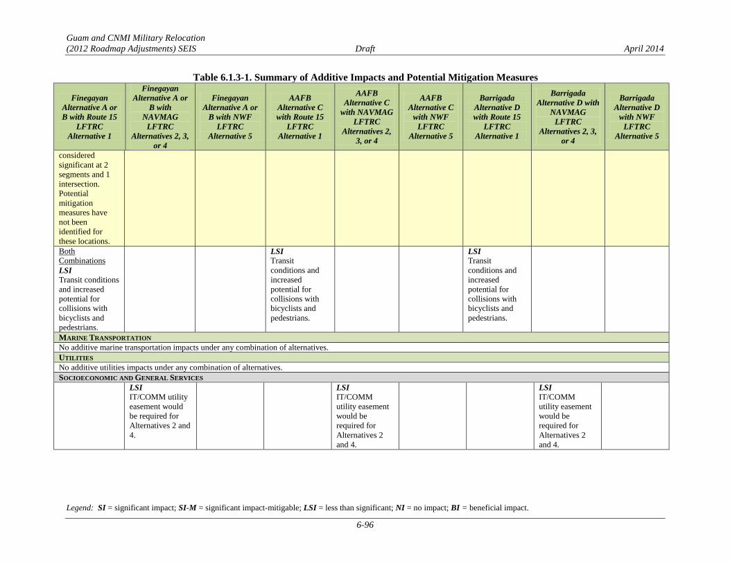
Guam and CNMI Military Relocation
(2012 Roadmap Adjustments) SEIS Draft April 2014
Legend: SI = significant impact; SI-M = significant impact-mitigable; LSI = less than significant; NI = no impact; BI = beneficial impact.
6-96
Table 6.1.3-1. Summary of Additive Impacts and Potential Mitigation Measures
Finegayan
Alternative A or
B with Route 15
LFTRC
Alternative 1
Finegayan
Alternative A or
B with
NAVMAG
LFTRC
Alternatives 2, 3,
or 4
Finegayan
Alternative A or
B with NWF
LFTRC
Alternative 5
AAFB
Alternative C
with Route 15
LFTRC
Alternative 1
AAFB
Alternative C
with NAVMAG
LFTRC
Alternatives 2,
3, or 4
AAFB
Alternative C
with NWF
LFTRC
Alternative 5
Barrigada
Alternative D
with Route 15
LFTRC
Alternative 1
Barrigada
Alternative D with
NAVMAG
LFTRC
Alternatives 2, 3,
or 4
Barrigada
Alternative D
with NWF
LFTRC
Alternative 5
considered
significant at 2
segments and 1
intersection.
Potential
mitigation
measures have
not been
identified for
these locations.
Both
Combinations
LSI
Transit conditions
and increased
potential for
collisions with
bicyclists and
pedestrians.
LSI
Transit
conditions and
increased
potential for
collisions with
bicyclists and
pedestrians.
LSI
Transit
conditions and
increased
potential for
collisions with
bicyclists and
pedestrians.
MARINE TRANSPORTATION
No additive marine transportation impacts under any combination of alternatives.
UTILITIES
No additive utilities impacts under any combination of alternatives.
SOCIOECONOMIC AND GENERAL SERVICES
LSI
IT/COMM utility
easement would
be required for
Alternatives 2 and
4.
LSI
IT/COMM
utility easement
would be
required for
Alternatives 2
and 4.
LSI
IT/COMM
utility easement
would be
required for
Alternatives 2
and 4.

Guam and CNMI Military Relocation
(2012 Roadmap Adjustments) SEIS Draft April 2014
Legend: SI = significant impact; SI-M = significant impact-mitigable; LSI = less than significant; NI = no impact; BI = beneficial impact.
6-97
Table 6.1.3-1. Summary of Additive Impacts and Potential Mitigation Measures
Finegayan
Alternative A or
B with Route 15
LFTRC
Alternative 1
Finegayan
Alternative A or
B with
NAVMAG
LFTRC
Alternatives 2, 3,
or 4
Finegayan
Alternative A or
B with NWF
LFTRC
Alternative 5
AAFB
Alternative C
with Route 15
LFTRC
Alternative 1
AAFB
Alternative C
with NAVMAG
LFTRC
Alternatives 2,
3, or 4
AAFB
Alternative C
with NWF
LFTRC
Alternative 5
Barrigada
Alternative D
with Route 15
LFTRC
Alternative 1
Barrigada
Alternative D with
NAVMAG
LFTRC
Alternatives 2, 3,
or 4
Barrigada
Alternative D
with NWF
LFTRC
Alternative 5
HAZARDOUS MATERIALS AND WASTE
LSI
Hazardous substances are not anticipated to be widely used or generated for the installation of IT/COMM lines at or between the main cantonment, housing, or LFTRC site; any use
would be managed according to best management practices. Contaminated sites would be avoided when possible, and a site-specific health and safety plan would be used to ensure
that the risk of human exposure to contaminated media is minimized. There would be no additive impacts uniquely associated with the site combinations or operation of the proposed
action.
PUBLIC HEALTH AND SAFETY
LSI
Added traffic in
areas with no
sidewalks would
increase the
potential that
bikers and
pedestrians may
be involved in a
collision.
NI
Travel distance
between sites is
short. There are
no high-frequency
crash intersections
along the route.
LSI
Added traffic in
areas with no
sidewalks would
increase the
potential that
bikers and
pedestrians may
be involved in a
collision.
LSI Travel distance
between sites is
relatively long.
5 high-crash
frequency
intersections
between the
Alternative A and
B area and
Alternative 2.
2 high-crash
frequency
intersections
between the
Alternative A and
B area and
Alternatives 3
LSI
Added traffic in
areas with no
sidewalks would
increase the
potential that
bikers and
pedestrians may
be involved in a
collision.
NI
Travel distance
between sites is
short. There are
no high-
frequency crash
intersections
along the route.
LSI
Added traffic in
areas with no
sidewalks would
increase the
potential that
bikers and
pedestrians may
be involved in a
collision.
NI
Travel distance
between sites is
short. There are
no high-
frequency crash
intersections
along the route.
LSI
Added traffic in
areas with no
sidewalks
would increase
the potential
that bikers and
pedestrians may
be involved in a
collision.
LSI Travel distance
between sites is
relatively long.
5 high-crash
frequency
intersections
between
Alternative C
area and
Alternative 2
and 2 between
Alternative C
area and
Alternatives 3
and 4. The
added vehicles
traveling
LSI
Added traffic in
areas with no
sidewalks
would increase
the potential
that bikers and
pedestrians may
be involved in a
collision.
NI
Travel distance
between sites is
short. There are
no high-
frequency crash
intersections
along the route.
LSI
Added traffic in
areas with no
sidewalks would
increase the
potential that
bikers and
pedestrians may
be involved in a
collision.
LSI Travel distance
between sites is
relatively short.
1 high-crash
frequency
intersections
between
Alternative D
area and
Alternative 1.
LSI
Added traffic in
areas with no
sidewalks would
increase the
potential that
bikers and
pedestrians may be
involved in a
collision.
LSI Travel distance
between sites is
relatively long. 1
high-crash
frequency
intersections
between
Alternative D area
and Alternatives 2,
3 and 4.
LSI
Added traffic in
areas with no
sidewalks
would increase
the potential
that bikers and
pedestrians may
be involved in a
collision.
LSI Travel distance
between sites is
relatively long.
2 high-crash
frequency
intersections
between
Alternative D
area and
Alternative 5.
Traffic
improvements
were completed
in 2012.
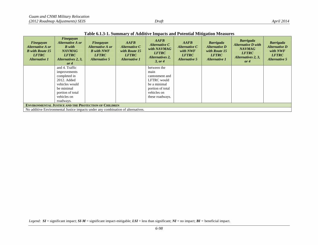
Guam and CNMI Military Relocation
(2012 Roadmap Adjustments) SEIS Draft April 2014
Legend: SI = significant impact; SI-M = significant impact-mitigable; LSI = less than significant; NI = no impact; BI = beneficial impact.
6-98
Table 6.1.3-1. Summary of Additive Impacts and Potential Mitigation Measures
Finegayan
Alternative A or
B with Route 15
LFTRC
Alternative 1
Finegayan
Alternative A or
B with
NAVMAG
LFTRC
Alternatives 2, 3,
or 4
Finegayan
Alternative A or
B with NWF
LFTRC
Alternative 5
AAFB
Alternative C
with Route 15
LFTRC
Alternative 1
AAFB
Alternative C
with NAVMAG
LFTRC
Alternatives 2,
3, or 4
AAFB
Alternative C
with NWF
LFTRC
Alternative 5
Barrigada
Alternative D
with Route 15
LFTRC
Alternative 1
Barrigada
Alternative D with
NAVMAG
LFTRC
Alternatives 2, 3,
or 4
Barrigada
Alternative D
with NWF
LFTRC
Alternative 5
and 4. Traffic
improvements
completed in
2012. Added
vehicles would
be minimal
portion of total
vehicles on
roadways.
between the
main
cantonment and
LFTRC would
be a minimal
portion of total
vehicles on
these roadways.
ENVIRONMENTAL JUSTICE AND THE PROTECTION OF CHILDREN
No additive Environmental Justice impacts under any combination of alternatives.
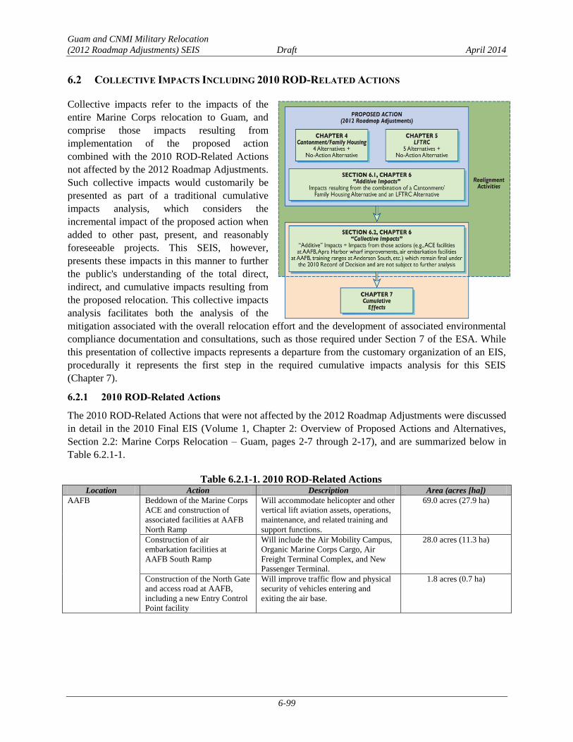
Guam and CNMI Military Relocation
(2012 Roadmap Adjustments) SEIS Draft April 2014
6-99
6.2 COLLECTIVE IMPACTS INCLUDING 2010 ROD-RELATED ACTIONS
Collective impacts refer to the impacts of the
entire Marine Corps relocation to Guam, and
comprise those impacts resulting from
implementation of the proposed action
combined with the 2010 ROD-Related Actions
not affected by the 2012 Roadmap Adjustments.
Such collective impacts would customarily be
presented as part of a traditional cumulative
impacts analysis, which considers the
incremental impact of the proposed action when
added to other past, present, and reasonably
foreseeable projects. This SEIS, however,
presents these impacts in this manner to further
the public's understanding of the total direct,
indirect, and cumulative impacts resulting from
the proposed relocation. This collective impacts
analysis facilitates both the analysis of the
mitigation associated with the overall relocation effort and the development of associated environmental
compliance documentation and consultations, such as those required under Section 7 of the ESA. While
this presentation of collective impacts represents a departure from the customary organization of an EIS,
procedurally it represents the first step in the required cumulative impacts analysis for this SEIS
(Chapter 7).
6.2.1 2010 ROD-Related Actions
The 2010 ROD-Related Actions that were not affected by the 2012 Roadmap Adjustments were discussed
in detail in the 2010 Final EIS (Volume 1, Chapter 2: Overview of Proposed Actions and Alternatives,
Section 2.2: Marine Corps Relocation – Guam, pages 2-7 through 2-17), and are summarized below in
Table 6.2.1-1.
Table 6.2.1-1. 2010 ROD-Related Actions
Location Action Description Area (acres [ha])
AAFB Beddown of the Marine Corps
ACE and construction of
associated facilities at AAFB
North Ramp
Will accommodate helicopter and other
vertical lift aviation assets, operations,
maintenance, and related training and
support functions.
69.0 acres (27.9 ha)
Construction of air
embarkation facilities at
AAFB South Ramp
Will include the Air Mobility Campus,
Organic Marine Corps Cargo, Air
Freight Terminal Complex, and New
Passenger Terminal.
28.0 acres (11.3 ha)
Construction of the North Gate
and access road at AAFB,
including a new Entry Control
Point facility
Will improve traffic flow and physical
security of vehicles entering and
exiting the air base.
1.8 acres (0.7 ha)

Guam and CNMI Military Relocation
(2012 Roadmap Adjustments) SEIS Draft April 2014
6-100
Table 6.2.1-1. 2010 ROD-Related Actions
Location Action Description Area (acres [ha])
Andersen South Development of a non-firing
training range complex to
include maneuver training and
landing zones
Will include facilities for Military
Operations on Urban Terrain and
maneuver training, including a
Breacher House. Will also include
landing zones to support training in
Confined Area Landing, External
Loads, and Helicopter
Insertion/Extraction.
2,000.0 acres (809.4 ha)
155.7 acres (63.0 ha) of
clearing/grading
Apra Harbor Waterfront functions at Apra
Harbor to support
embarkation, including wharf
and utility upgrades, and
associated dredging and
dredge disposal management
Berths and adjacent support structures
and lay-down areas will be upgraded to
accommodate increased usage and to
meet the new and emerging
requirements in support of the Marine
Corps relocation. Requirements include
embarkation operations, support vessel
transport berthing, escort ship berthing,
and an amphibious vehicle laydown
area. Dredging will be required to
accommodate some of the escort ships.
268.9 acres (108.8 ha)
172.2 acres (69.7 ha)
currently developed (will be
upgraded)
Relocation of Military
Working Dog Kennel
Existing dog kennel and administration
spaces will be relocated because noise
of embarkation will be incompatible
with the existing uses as a military
working dog kennel and training
location.
2.0 acres (0.8 ha)
Relocation of U.S. Coast
Guard
Ship berthing and crew support
buildings will be relocated to the
former Ship Repair Facility because
ships carrying amphibious vessels will
require the full length of Victor Wharf.
11.0 acres (4.5 ha)
Currently developed, no
impact
New Medical Clinic A new medical/dental clinic will
accommodate, in part, the increase in
on-island military population.
7.8 acres (3.1 ha)
Currently developed, will be
graded
NAVMAG Training activities, including
aviation training and non-
firing operations training
Will include maneuver training areas
and landing zones to support training in
Confined Area Landing, External
Loads, and Helicopter Insertion
Extraction.
3,253.1 acres (1,316.5 ha)
13.6 acre (5.5 ha)
clearing/grading
Access to the NAVMAG area
using the existing hiking trail
as the access road
The existing hiking trail will be used to
access NAVMAG. The trail will not be
improved and will be used by foot
traffic only.
0.0 acres (0.0 ha)
Use of Parsons Road area for
the location of additional
ammunition storage at
NAVMAG
Earth-covered magazines will be
located at the existing munitions
storage area.
8.8 acres (3.6 ha)
Roadway Projects Route 1 and Route 8
intersection and improvement
(Hagåtña) (GRN1)
Intersection improvements (0.24 mile
[0.24 km]) on Route 1 and (0.09 mile
[0.14 km] on Route 8) to provide two
left-turn lanes and two right-turn lanes
for northbound Route 8 approaching
Route 1.
0.0 acre (0.0 ha)
Route 1 and Route 3
intersection and roadway
improvements (Dededo)
(GRN2)
Intersection improvements (0.15 mile
[0.39 km]) on Route 1 and (0.04 mile
[0.06 km] on Route 3) to provide
southbound left, combined left/right,
and free right with acceleration lane;
east to north double left-turn lane.
0.0 acre (0.0 ha)
Guam and CNMI Military Relocation
(2012 Roadmap Adjustments) SEIS Draft April 2014
6-101
Table 6.2.1-1. 2010 ROD-Related Actions
Location Action Description Area (acres [ha])
Replacement of Hagåtña
(Agana) Bridge #1 with
reinforced concrete (GRN3)
Agana Bridge replacement.
0.2 acre (0.06 ha)
Route 11 roadway
improvements from the port to
Route 1, including pavement
strengthening (GRN4)
Pavement strengthening of two lanes. 0.0 acre (0.0 ha)
Widening of the Route 1 and
Route 11 intersection, adding a
second left turn lane and
pavement strengthening
(GRN5)
Intersection improvements (0.12 mile
[0.19 km]) on Route 1.
0.0 acre (0.0 ha)
The following sections summarize the impacts to each resource from the 2010 ROD-Related Actions
listed above and discussed in Volume 2 of the 2010 Final EIS. Impacts in the following sections are
discussed in the future tense although it should be noted that some impacts resulting from construction
and operations are occurring, or may have already occurred.
Geological and Soil Resources 6.2.1.1
As discussed in the 2010 Final EIS (Volume 2: Marine Corps - Guam, Chapter 3: Geological and Soil
Resources, Section 3.2.2: Alternative 1, pages 3-34 to 3-49; Volume 6: Related Actions, Chapter 5:
Geological and Soil Resources, Section 5.2.6.2: Alternative 2, pages 5-19 to 5-20), construction activities
will include clearing, grading and grubbing, demolition of existing road pavement, earthwork, and
landscaping on a total of approximately 383.6 acres (155.2 ha). Cut soil will be used as fill material
whenever possible to minimize impacts to soil. Soil types that will be disturbed are not agriculturally
productive, and BMPs will be utilized to minimize soil erosion. Proposed developments are located on
relatively flat areas that are not subject to slope instability. There will be no adverse impacts to the
sinkhole at North Ramp. Established procedures will be implemented to minimize topsoil loss,
compaction, and erosion from training activities.
Water Resources 6.2.1.2
As discussed in the 2010 Final EIS (Volume 2: Marine Corps - Guam, Chapter 4: Water Resources,
Section 4.2.2: Alternative 1, pages 4-84 to 4-118) there will be no direct impacts to surface waters or
wetlands. Construction activities will result in the potential for an increase in stormwater runoff, erosion,
and sedimentation, and the increase in impervious area will result in a minor increase in stormwater
intensities and volume. LID measures and BMPs will be implemented to protect surface water and
groundwater quality. There will be direct impacts to nearshore waters from the wharf improvement
projects at Apra Harbor, and nearshore water quality will be temporarily impacted during the dredging
process in Inner Apra Harbor. In addition, construction activities at Apra Harbor could result in runoff
that could be transported to or directly released to nearshore waters. Strict adherence to all applicable
legal requirements will reduce potential impacts to surface waters, groundwater, nearshore waters, and
wetlands.
As discussed in the 2010 Final EIS (Volume 6: Related Actions, Chapter 6: Water Resources, Section
6.2.6.2: Alternative 2, page 6-34), construction activities associated with the Hagåtña (Agana) Bridge #1
replacement will cause an unavoidable loss of 0.2 acre (0.06 ha) of waters of the U.S. However, this
impact will be minimized through (1) use of construction and source control BMPs cooperatively
developed by FHWA and GEPA, and (2) improved hydraulic conveyance under the proposed bridge/box
Guam and CNMI Military Relocation
(2012 Roadmap Adjustments) SEIS Draft April 2014
6-102
culvert replacement, which will serve to reduce erosion and sedimentation downstream. Through the
development and implementation of site-specific construction BMPs, coordination with regulatory
agencies, and adherence to applicable orders, laws, and regulations relating to water quality, construction
activities will result in less than significant impacts to surface water, groundwater, and nearshore waters.
In the operational phase, no impacts to floodplains are anticipated. Diversion of drainage from one
watershed to another will be avoided. Roadway-specific BMPs will be included in the project planning,
design, and construction. All operations will be implemented in accordance with all applicable federal,
local, and military orders, laws, and regulations. Therefore, impacts to surface water, groundwater, and
nearshore waters from the 2010 ROD-Related Actions will be less than significant.
Air Quality 6.2.1.3
As discussed in the 2010 Final EIS (Volume 2: Marine Corps - Guam, Chapter 5: Air Quality, Section
5.2.2: Alternative 1, pages 5-18 to 5-29; Volume 6: Related Actions, Chapter 7: Air Quality, Section
7.2.6.3: Alternative 2, pages 7-48 to 7-54), construction and operation of the facilities will result in air
emissions. Construction emissions will include SO2, CO, PM10, PM2.5, NOx, VOC, and CO2; however,
construction will be short-term and localized. Aircraft and helicopter engines emit criteria pollutants
during all phases of operation. There will also be vehicle emissions during training exercises. Air
emissions associated with both construction and operation of the 2010 ROD-Related Actions will be well
below the significance criteria of 250 tpy for all criteria air pollutants.
Noise 6.2.1.4
The 2010 Final EIS (Volume 2: Marine Corps - Guam, Chapter 6: Noise, Section 6.2.2: Alternative 1,
pages 6-23 to 6-42; Volume 6: Related Actions, Chapter 8: Noise, Section 8.2.6.1: Alternative 1, pages 8-
12 to 8-40) discusses noise impacts from construction and operation of the 2010 ROD-Related Actions.
Construction noise will be temporary, and heavy equipment that will generate the highest noise levels will
not be used consistently enough to exceed the USEPA guidance level of 75 dBA for more than one hour
beyond DoD installation boundaries. Additionally, terrain and distance from construction activities will
lessen noise impacts to sensitive receptors outside of the construction areas. There may be localized noise
for brief periods from temporary increases in truck traffic, but there will not be an adverse noise impact to
human health, neighboring communities, or within installations. Airfield operations will increase noise
for some additive residences within the 60-70 dBA DNL zones, but there will not be a significant impact
to human health or hearing. Non-firing training will include new sources of ground-based noise from
vehicle use on existing roads, the convoy course, and the Advanced Motor Vehicle Operator’s Course in
the maneuver training area, but these noise characteristics are similar to standard commercial vehicles.
Most maneuver training will occur within the core of the maneuver training area, and noise setbacks will
be established along the boundaries with the urban interface. Abatement measures for noise impacts
associated with roadway projects are included as part of the project, where feasible.
Airspace 6.2.1.5
As discussed in the 2010 Final EIS (Volume 2: Marine Corps - Guam, Chapter 7: Airspace, Section 7.2.2:
Alternative 1, pages 7-13 to 7-15), there will be an increase in total aircraft based at AAFB as well as
associated aircraft operations. However, there will be no change to any of the approach and departure
patterns associated with the airports/airfields at AAFB. The existing SUA will be used to conduct aircrew
flight training, and low level training routes and landing zones will be established over Guam following
VFR rules and procedures, and will not impact established flight paths. There will be no restrictions on
access to, and no effect on, the use of Guam International Airport. In addition, there will be no effect on
airport or airfield arrival and departure traffic flows due to the increase in military aircraft.

Guam and CNMI Military Relocation
(2012 Roadmap Adjustments) SEIS Draft April 2014
6-103
Land and Submerged Land Use 6.2.1.6
All of the non-roadway 2010 ROD-Related Actions will be constructed and operated at existing DoD
facilities (2010 Final EIS, Volume 2: Marine Corps - Guam, Chapter 8: Land and Submerged Land Use,
Section 8.2.3: Alternative 1, pages 8-59 to 8-75). There will be no change in land or submerged land use,
no new public access restrictions, and all activities are consistent with land and submerged land use plans.
Impacts from construction of the roadway projects, as discussed in the 2010 Final EIS (Volume 6:
Related Actions, Chapter 10: Land and Submerged Land Use, Section 10.2.6.1: Alternative 1, page 10-
12) will be typical of a public works maintenance project, with occasional disruption to
business/commercial and tourist facilities. A Traffic Management Plan will be developed for
implementation during construction activities.
Recreational Resources 6.2.1.7
As discussed in the 2010 Final EIS (Volume 2: Marine Corps - Guam, Chapter 9: Recreational Resources,
Section 9.2.2: Alternative 1, pages 9-19 to 9-26; Volume 6: Related Actions, Chapter 11: Recreational
Resources, Section 11.2.6.2, pages 11-9 to 11-10), construction of the 2010 ROD-Related Actions will
result in an increase in construction-related vehicles on the roadways. This increase may cause delay for
persons attempting to gain access to recreational resources. Construction activities will be short-term and
localized. A Traffic Management Plan will be developed for implementation during roadway construction
activities. All airfield and training operations will occur on DoD property. The training area at Andersen
South will result in the loss of use of the Andersen South roads by joggers and walkers by fencing off the
property and the addition of gates, however this resource is not unique to the region and there are
comparable resources available in the adjoining properties.
Terrestrial Biological Resources 6.2.1.8
As discussed in the 2010 Final EIS (Volume 2: Marine Corps – Guam, Chapter 10: Terrestrial Biological
Resources, Section 10.2.2: Alternative 1, pages 10-90 to 10-169), a total of 7.5 acres (3 ha) of primary
limestone forest and 131 acres (53 ha) of secondary or disturbed limestone forest at AAFB will be
removed. However, much of this forest area is not contiguous (i.e., the sum of the impacted forested area
is from a number of different projects that are not collocated) or is adjacent to developed and previously
disturbed areas.
As discussed in the 2010 Final EIS (Volume 6: Related Actions, Chapter 12: Terrestrial Biological
Resources, Section 12.2.6.1: Alternative 1, pages 12-36 to 12-42), negligible direct impacts to aquatic
habitats (approximately 0.15 acres [0.06 ha]) would occur from the replacement of Hagåtña Bridge #1
with reinforced concrete. Indirect impacts to aquatic habitats would be limited to potential sedimentation
along the 260 feet (79 m) between the bridge and the river’s terminus. Impacts to potential habitat for
special-status species from the 2010 ROD-Related Actions are not significant.
Construction activities will displace wildlife from potentially suitable habitat in the project areas;
however, construction activities are short-term and localized, and displaced species are abundant and are
expected to repopulate suitable portions of the project areas upon completion of construction.
No vegetation will be cleared during training operations. In addition, with implementation of established
BMPs and mitigation measures identified in the 2010 Final EIS, the introduction or spread of invasive
species is not anticipated.
Guam and CNMI Military Relocation
(2012 Roadmap Adjustments) SEIS Draft April 2014
6-104
Marine Biological Resources 6.2.1.9
As discussed in the 2010 Final EIS (Volume 2: Marine Corps - Guam, Chapter 11: Marine Biological
Resources, Section 11.2.2: Alternative 1, pages 11-73 to 11-113) and as covered in the Marine Biological
Opinion (USFWS 2010), the only direct impacts to marine biological resources would be associated with
wharf improvement construction activities at Apra Harbor. Marine flora, invertebrates, and associated
EFH will not be appreciably modified from existing conditions, and impacts will be short-term and minor.
Increases of construction-related vessel movements could result in localized disturbance and displacement
of fish species as a result of the potential for increased turbidity, increased benthic sedimentation, impacts
to eggs and larvae in the upper water column, and seasonal disturbances to spawning coral reef and
pupping scalloped hammerhead sharks. These impacts will be short-term, periodic, and localized. Green
sea turtles will be protected by postponing in-water construction activities when green sea turtles are
detected in the area. Additionally, green sea turtles are highly mobile and it is expected that dredging and
pile driving activities will deter green sea turtles from closely approaching work areas.
Impacts to marine biological resources from roadway projects, as summarized in Table 13.2-8 of the 2010
Final EIS (Volume 6: Related Actions, Chapter 13: Marine Biological Resources, page 13-39), would
include indirect impacts during construction and operation from increased runoff and potential for
sedimentation of marine waters.
Cultural Resources 6.2.1.10
The 2010 ROD-Related Actions consist of construction at North Ramp, South Ramp, and a North Gate on
AAFB, development of the non-firing training range complex at Andersen South, wharf upgrades and
construction at Naval Base Guam, and construction of ammunition magazines and aviation training at the
NAVMAG. These specific project areas were intensively investigated as described in the 2010 Final EIS
(Volume 2: Marine Corps – Guam, Chapter 12: Cultural Resources, Section 12.1, pages 12-1 to 12-38.
The 2010 ROD-Related Actions, as discussed in the 2010 Final EIS (Volume 2: Marine Corps - Guam,
Chapter 12: Cultural Resources, Section 12.2.2: Alternative 1, pages 12-41 to 12-54; Volume 6), would
potentially affect 11 historic properties, including seven within the airfield and training areas at AAFB,
two within NAVMAG, and two within the training areas at Andersen South (Table 6.2.1-2). No adverse
effects would occur to historic properties at Apra Harbor or Naval Base Guam. No historic architectural
properties eligible for the NRHP would be adversely affected. Less than significant impacts would occur
due to the use of the existing foot trail at NAVMAG. There would be no impacts to TCPs or resources of
cultural importance from the implementation of these actions.
Additional 2010 ROD-Related Actions include the five roadway projects along Route 1, which are
discussed in Volume 6 of the 2010 Final EIS (Volume 6: Related Actions, Chapter 14: Cultural
Resources, Section 14.2.6.1: Alternative 1, page 14-19). The intersection improvement and pavement
strengthening projects would not impact cultural resources. Hagåtña (Agana) Bridge is a historic property.
However, the bridge will be reconstructed in its historic location, and mitigation will preserve the only
remaining historic attributes and features contributing to the bridge’s NRHP eligibility; therefore,
FHWA found that, with mitigation, the project will have no adverse effect on Hagåtña (Agana) Bridge.
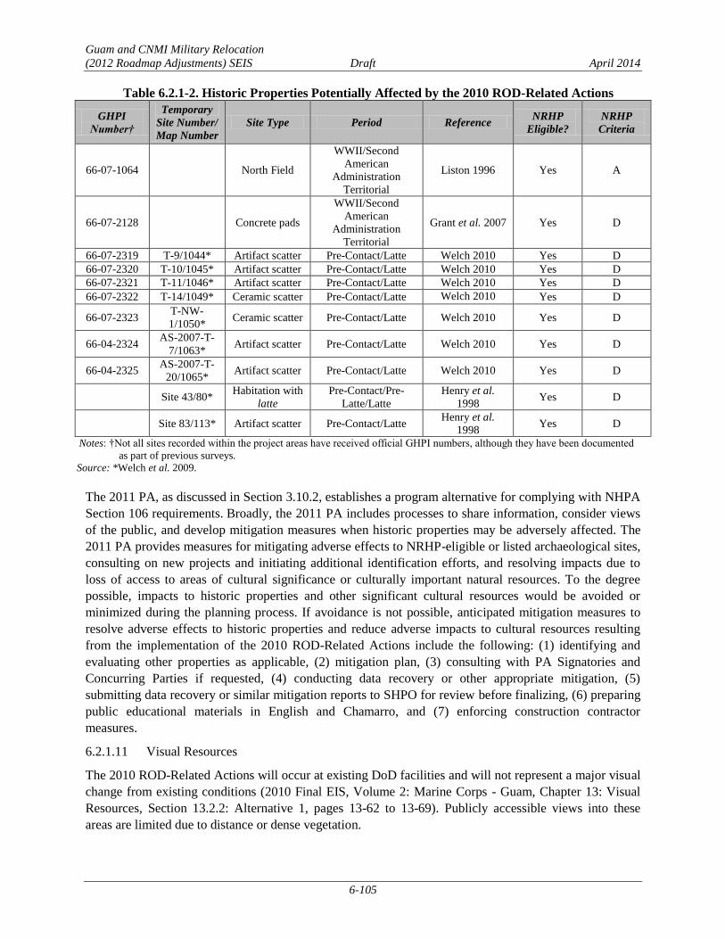
Guam and CNMI Military Relocation
(2012 Roadmap Adjustments) SEIS Draft April 2014
6-105
Table 6.2.1-2. Historic Properties Potentially Affected by the 2010 ROD-Related Actions
GHPI
Number†
Temporary
Site Number/
Map Number
Site Type Period Reference NRHP
Eligible?
NRHP
Criteria
66-07-1064 North Field
WWII/Second
American
Administration
Territorial
Liston 1996 Yes A
66-07-2128 Concrete pads
WWII/Second
American
Administration
Territorial
Grant et al. 2007 Yes D
66-07-2319 T-9/1044* Artifact scatter Pre-Contact/Latte Welch 2010 Yes D
66-07-2320 T-10/1045* Artifact scatter Pre-Contact/Latte Welch 2010 Yes D
66-07-2321 T-11/1046* Artifact scatter Pre-Contact/Latte Welch 2010 Yes D
66-07-2322 T-14/1049* Ceramic scatter Pre-Contact/Latte Welch 2010 Yes D
66-07-2323 T-NW-
1/1050* Ceramic scatter Pre-Contact/Latte Welch 2010 Yes D
66-04-2324 AS-2007-T-
7/1063* Artifact scatter Pre-Contact/Latte Welch 2010 Yes D
66-04-2325 AS-2007-T-
20/1065* Artifact scatter Pre-Contact/Latte Welch 2010 Yes D
Site 43/80* Habitation with
latte
Pre-Contact/Pre-
Latte/Latte
Henry et al.
1998 Yes D
Site 83/113* Artifact scatter Pre-Contact/Latte Henry et al.
1998 Yes D
Notes: †Not all sites recorded within the project areas have received official GHPI numbers, although they have been documented
as part of previous surveys.
Source: *Welch et al. 2009.
The 2011 PA, as discussed in Section 3.10.2, establishes a program alternative for complying with NHPA
Section 106 requirements. Broadly, the 2011 PA includes processes to share information, consider views
of the public, and develop mitigation measures when historic properties may be adversely affected. The
2011 PA provides measures for mitigating adverse effects to NRHP-eligible or listed archaeological sites,
consulting on new projects and initiating additional identification efforts, and resolving impacts due to
loss of access to areas of cultural significance or culturally important natural resources. To the degree
possible, impacts to historic properties and other significant cultural resources would be avoided or
minimized during the planning process. If avoidance is not possible, anticipated mitigation measures to
resolve adverse effects to historic properties and reduce adverse impacts to cultural resources resulting
from the implementation of the 2010 ROD-Related Actions include the following: (1) identifying and
evaluating other properties as applicable, (2) mitigation plan, (3) consulting with PA Signatories and
Concurring Parties if requested, (4) conducting data recovery or other appropriate mitigation, (5)
submitting data recovery or similar mitigation reports to SHPO for review before finalizing, (6) preparing
public educational materials in English and Chamarro, and (7) enforcing construction contractor
measures.
Visual Resources 6.2.1.11
The 2010 ROD-Related Actions will occur at existing DoD facilities and will not represent a major visual
change from existing conditions (2010 Final EIS, Volume 2: Marine Corps - Guam, Chapter 13: Visual
Resources, Section 13.2.2: Alternative 1, pages 13-62 to 13-69). Publicly accessible views into these
areas are limited due to distance or dense vegetation.

Guam and CNMI Military Relocation
(2012 Roadmap Adjustments) SEIS Draft April 2014
6-106
Roadway projects, as discussed in the 2010 Final EIS (Volume 6: Related Actions, Chapter 15: Visual
Resources, Section 15.2.6.1: Alternative 1, pages 15-8 to 15-26) will not have an adverse impact on the
existing visual environment. Replacement of the Hagåtña (Agana) Bridge will include mitigation
measures that address the aesthetics of the bridge, which will increase the visual quality.
Ground Transportation 6.2.1.12
Impacts to ground transportation from implementation of the 2010 ROD-Related Actions will be limited
to the construction period. There may be potential temporary congestion associated with the delivery of
construction materials and equipment, removal of construction debris, and parking for construction
workers. Construction will be short-term, temporary, and localized. A Traffic Management Plan will be
developed for implementation during roadway construction activities.
Marine Transportation 6.2.1.13
As discussed in the 2010 Final EIS (Volume 2: Marine Corps - Guam, Chapter 14: Marine
Transportation, Section 14.2.2: Alternative 1, pages 14-10 to 14-15) additional container and break-bulk
cargo ships will be required to transport equipment and supplies necessary for the construction of the
2010 ROD-Related Actions. Additionally, the dredging of Sierra Wharf will require transportation of
dredged material over a period of six to nine months. There has been a steady and substantial decline in
the number of commercial vessels visiting the Port of Guam from 1995 through 2012. The number of
vessels associated with the 2010 ROD-Related Actions is well below the total number of vessels visiting
the Port of Guam in 1995, which had the highest number of vessel visits between 1995 through 2012. As
the additional number of vessels is much less than the difference between the number of current (2012)
vessel visits and the number of vessel visits in 1995, there will be no impacts to marine transportation
from construction of the 2010 ROD-Related Actions.
Utilities 6.2.1.14
As discussed in the 2010 Final EIS (Volume 1: Overview of Proposed Actions and Alternatives, Chapter
2: Overview of Proposed Actions, Section 2.2: Marine Corps Relocation – Guam, pages 2-7 to 2-17), the
2010 ROD-related actions not affected by the 2012 Roadmap Adjustments will require localized and
relatively small increased demand for utilities. Primary utility needs will be local to Apra Harbor. The
total utility requirements for the 2012 Roadmap Adjustments Proposed Action, including those from the
2010 ROD-related actions, have been included in the SEIS utilities assessments. Utilities will be installed
at facilities using BMPs and standard construction and operation procedures and requirements to
minimize impacts to existing utilities. The existing utilities can accommodate the additional usage at the
new facilities.
Socioeconomics and General Services 6.2.1.15
The 2010 Final EIS (Volume 2: Marine Corps - Guam, Chapter 16: Socioeconomics and General
Services, Section 16.2.2: Proposed Action and Section 16.2.3: Land Acquisition Impacts, pages 16-73 to
16-147) assesses impacts based on an increase in population and land acquisition. There will be no
increase in population attributable specifically to construction and operation of the 2010 ROD-Related
Actions. Additionally, the 2010 ROD-Related Actions will not require land acquisition.
Hazardous Materials and Wastes 6.2.1.16
As discussed in the 2010 Final EIS (Volume 2: Marine Corps - Guam, Chapter 17: Hazardous Materials
and Waste, Section 17.2.2: Alternative 1, pages 17-38 to 17-55), construction of the 2010 ROD-Related
Actions will result in the use and disposal of more hazardous materials. There is the potential for an

Guam and CNMI Military Relocation
(2012 Roadmap Adjustments) SEIS Draft April 2014
6-107
inadvertent spill, release, or leak of hazardous materials. Hazardous materials will be handled and
disposed of per applicable BMPs and SOPs.
Public Health and Safety 6.2.1.17
As discussed in the 2010 Final EIS (Volume 2: Marine Corps - Guam, Chapter 18: Public Health and
Safety, Section 18.2.2: Alternative 1, pages 18-13 to 18-23; Volume 6: Related Actions, Chapter 19:
Public Health and Safety, Section 19.2.9.1: Alternative 1, pages 19-17 to 19-18), there may be impacts
associated with UXO and traffic accidents, as well as impacts to noise, water quality, and air quality.
These impacts will be minimal and will be limited primarily to the construction period, which will be
short-term and localized. UXO may be encountered during construction or during operations.
Training activities associated with the 2010 ROD-Related Actions have minimal potential to impact
public health and safety. The public will be notified prior to training activities, and all training activities
will occur within established on-base training areas. Specific and documented procedures will be
implemented to reduce the potential for interaction between the public and training personnel and to
ensure that the public is not endangered by training activities.
Environmental Justice and the Protection of Children 6.2.1.18
As discussed in the 2010 Final EIS (Volume 2: Marine Corps - Guam, Chapter 19: Environmental Justice
and the Protection of Children, Section 19.2.2: Alternative 1, pages 19-11 to 19-18; Volume 6: Related
Actions, Chapter 20: Environmental Justice and the Protection of Children, Section 20.2.8: Summary of
Impacts, page 20-20), there will be an increase in construction-related noise, traffic, and safety concerns
during construction of the 2010 ROD-Related Actions. These impacts will be short-term, temporary, and
localized, and will not disproportionately impact minority or low-income populations or children. A
Traffic Management Plan will be prepared and implemented during roadway construction. Completion of
the roadway projects will have a beneficial impact due to improved and safer roadway infrastructure.
Summary of Impacts Associated with the 2010-Related Actions 6.2.1.19
Table 6.2.1-3 summarizes the potential impacts to each resource from the 2010 ROD-Related Actions.
Table 6.2.1-3. Summary of Potential Impacts from Implementation of the 2010 ROD-Related Actions
Resource Impact
Geological and Soil Resources Total disturbed acreage from construction is approximately 383.6 acres (155.2 ha). There is one
sinkhole in the vicinity of the North Ramp that will not be adversely impacted.
Water Resources BMPs will be utilized to minimize the indirect impacts to groundwater and surface water.
There will be no loss of wetlands. There will be direct but temporary impacts to nearshore
waters from dredging at Inner Apra Harbor.
Air Quality Increase in emissions, including SO2 and hot spot PM, CO, and MSATs concentrations, will be
below applicable impact significance thresholds.
Noise Construction noise will be temporary and will be within existing DoD property boundaries.
Noise from airfield operations and training functions will not have a significant or adverse
impact to human health or hearing.
Airspace There will be an increase in total aircraft based at AAFB and associated aircraft operations;
however, there will be no change to any of the approach and departure patterns associated with
the airports/airfields at AAFB and there will be no restrictions on access to, and no effect on the
use of Guam International Airport Route There will be no measurable change in airspace
requirements or management procedures.
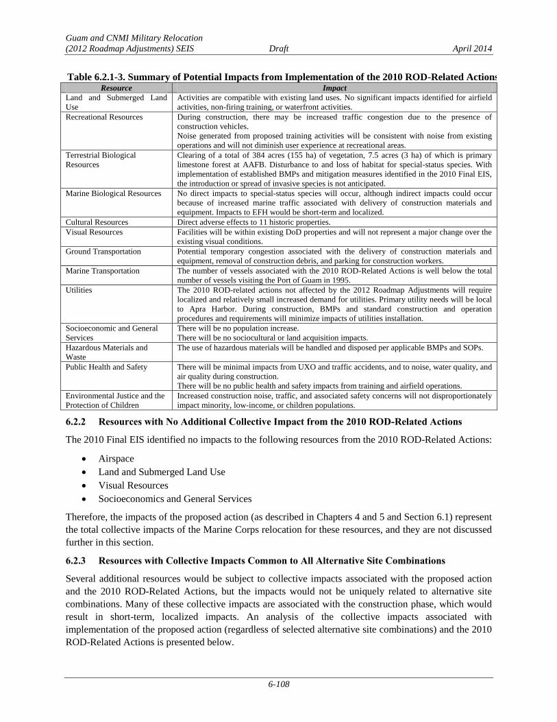
Guam and CNMI Military Relocation
(2012 Roadmap Adjustments) SEIS Draft April 2014
6-108
Table 6.2.1-3. Summary of Potential Impacts from Implementation of the 2010 ROD-Related Actions
Resource Impact
Land and Submerged Land
Use
Activities are compatible with existing land uses. No significant impacts identified for airfield
activities, non-firing training, or waterfront activities.
Recreational Resources During construction, there may be increased traffic congestion due to the presence of
construction vehicles.
Noise generated from proposed training activities will be consistent with noise from existing
operations and will not diminish user experience at recreational areas.
Terrestrial Biological
Resources
Clearing of a total of 384 acres (155 ha) of vegetation, 7.5 acres (3 ha) of which is primary
limestone forest at AAFB. Disturbance to and loss of habitat for special-status species. With
implementation of established BMPs and mitigation measures identified in the 2010 Final EIS,
the introduction or spread of invasive species is not anticipated.
Marine Biological Resources No direct impacts to special-status species will occur, although indirect impacts could occur
because of increased marine traffic associated with delivery of construction materials and
equipment. Impacts to EFH would be short-term and localized.
Cultural Resources Direct adverse effects to 11 historic properties.
Visual Resources Facilities will be within existing DoD properties and will not represent a major change over the
existing visual conditions.
Ground Transportation Potential temporary congestion associated with the delivery of construction materials and
equipment, removal of construction debris, and parking for construction workers.
Marine Transportation The number of vessels associated with the 2010 ROD-Related Actions is well below the total
number of vessels visiting the Port of Guam in 1995.
Utilities The 2010 ROD-related actions not affected by the 2012 Roadmap Adjustments will require
localized and relatively small increased demand for utilities. Primary utility needs will be local
to Apra Harbor. During construction, BMPs and standard construction and operation
procedures and requirements will minimize impacts of utilities installation.
Socioeconomic and General
Services
There will be no population increase.
There will be no sociocultural or land acquisition impacts.
Hazardous Materials and
Waste
The use of hazardous materials will be handled and disposed per applicable BMPs and SOPs.
Public Health and Safety There will be minimal impacts from UXO and traffic accidents, and to noise, water quality, and
air quality during construction.
There will be no public health and safety impacts from training and airfield operations.
Environmental Justice and the
Protection of Children
Increased construction noise, traffic, and associated safety concerns will not disproportionately
impact minority, low-income, or children populations.
6.2.2 Resources with No Additional Collective Impact from the 2010 ROD-Related Actions
The 2010 Final EIS identified no impacts to the following resources from the 2010 ROD-Related Actions:
Airspace
Land and Submerged Land Use
Visual Resources
Socioeconomics and General Services
Therefore, the impacts of the proposed action (as described in Chapters 4 and 5 and Section 6.1) represent
the total collective impacts of the Marine Corps relocation for these resources, and they are not discussed
further in this section.
6.2.3 Resources with Collective Impacts Common to All Alternative Site Combinations
Several additional resources would be subject to collective impacts associated with the proposed action
and the 2010 ROD-Related Actions, but the impacts would not be uniquely related to alternative site
combinations. Many of these collective impacts are associated with the construction phase, which would
result in short-term, localized impacts. An analysis of the collective impacts associated with
implementation of the proposed action (regardless of selected alternative site combinations) and the 2010
ROD-Related Actions is presented below.

Guam and CNMI Military Relocation
(2012 Roadmap Adjustments) SEIS Draft April 2014
6-109
Geological and Soil Resources 6.2.3.1
Collective impacts to soil resources would result from the increased acreage of disturbance, including
clearing, grading and grubbing, earthwork, and landscaping. BMPs would be utilized to minimize soil
erosion. Therefore, the collective impact to soil resources would be less than significant.
There are numerous sinkholes and depressions identified, as well as the potential for sinkholes and
depressions at several of the proposed alternative locations. There is one sinkhole identified at North
Ramp. For any sinkholes discovered before or during construction, BMPs would include compliance with
the requirements of 22 GAR Chapter 10, Section 10106. With implementation of these BMPs, no adverse
impacts from sinkholes would occur due to construction. Therefore, the collective impact associated with
sinkholes and depressions would be less than significant.
There would not be a collective impact on topography. Although the 2010 ROD-Related Actions include
clearing, grading and grubbing, demolition of existing road pavement, earthwork, and landscaping on a
total of approximately 383.6 acres (155.2 ha), there would not be a significant amount of cut and fill that
would permanently alter the topography of the area. Although there is not a collective impact to
topography, impacts to topography remain significant due to the amount of cut and fill at the LFTRC
alternatives.
Water Resources 6.2.3.2
The 2010 ROD-Related Actions would have no direct impacts on surface waters or wetlands, therefore,
there would not be a collective direct impact to surface waters or wetlands. Additionally, although there
would be direct impacts to nearshore waters for the 2010 ROD-Related Actions, there would be no direct
impacts to nearshore waters from construction or operation of the proposed action, thus, there would not
be a collective direct impact to nearshore waters.
Stormwater runoff protection measures, including compliance with Construction General Permit
requirements and other regulations and implementation of BMPs, LID, and a Program SWPPP and site-
specific SWPPP, would minimize the collective indirect impacts. Groundwater demand from the NGLA
would be substantially less than the sustainable yield, but there would be localized significant impacts to
the NGLA that would be mitigated, as well as less than significant impacts to the overall NGLA.
Localized impacts to the NGLA would be managed through the numerical groundwater model and an
updated and expanded network of wells to monitor groundwater level and water quality. Therefore,
construction and operations would result in less than significant collective indirect impacts to water
resources.
Air Quality 6.2.3.3
Since the analysis described in Chapters 4 and 5 was performed for the maximum potential adverse effect,
the forecasts of location-specific traffic and construction activities impacts would remain representative
under this and other combined alternatives. Therefore, the localized mobile source concentration
collective impacts would be less than significant.
Recreational Resources 6.2.3.4
Collective impacts to recreational resources from implementation of the proposed actions and the 2010
ROD-Related Actions could result from both the increase in the workforce and associated increased use
of recreational resources during the construction phase. During construction there may be increased traffic
congestion that delays access to recreational resources due to the presence of construction vehicles.
However, there are no additional operational impacts beyond those discussed in Chapter 4. Any hindrance

Guam and CNMI Military Relocation
(2012 Roadmap Adjustments) SEIS Draft April 2014
6-110
of access caused by construction activities would be short-term and localized, and the collective impacts
to recreational resources would be less than significant.
Marine Biological Resources 6.2.3.5
Although there are direct impacts related to construction in Inner Apra Harbor for the 2010 ROD-Related
Actions, the proposed action would not create any additional collective impact.
Total vessel traffic is not anticipated to exceed historical maximum levels, and BMPs would be
implemented to minimize impacts to water quality from vessel operations. Therefore, the collective
impacts to marine biological resources would be less than significant.
Ground Transportation 6.2.3.6
As discussed in Section 6.2.1.12, impacts to ground transportation from implementation of the 2010
ROD-Related Actions will be limited to the construction period. During the construction period,
temporary and intermittent transportation impacts would result from truck movements, as well as
construction worker vehicles traveling to and from the site. Construction-related impacts generally would
not be considered significant due to their temporary nature and limited, finite duration. Therefore, any
collective impact to ground transportation from implementation of the proposed action and the 2010
ROD-Related Actions would be less than significant.
Marine Transportation 6.2.3.7
Implementation of the Proposed Action and the 2010 ROD-Related Actions concurrently would increase
the amount of vessel traffic in Apra Harbor during construction. The combined total number of predicted
vessel visits to Apra Harbor during construction is 514 vessel visits (127 barges of dredge spoils + 387
cargo ships [242 breakbulk +145 containers]). This, combined with the predicted number of background
vessel visits within the range of analysis shown in Section 4.1.13, would not exceed the recent maximum
number of annual vessel visits (in FY1995). Because the annual number of vessels visiting the Port of
Guam has decreased by 2,289 vessels over the period of FY1995 to FY2012, it is expected that the
additional predicted annual number of vessels visiting the Port of Guam would result in a less than
significant impact on marine transportation. Therefore, the collective impact from construction of the
proposed action and the 2010 ROD-Related Actions would be less than significant.
Utilities 6.2.3.8
Utility demands associated with the proposed action are primarily associated with the main
cantonment/family housing alternatives. To meet these demands, the proposed action included
development of a well field and upgrades to electrical lines, as discussed in Section 2.2.3. Utility demands
resulting from implementation of the 2010 ROD-Related Actions, LFTRC alternatives, and main
cantonment/family housing alternatives are of the same magnitude regardless of alternative, and would be
met by the existing utility infrastructure and utility upgrades associated with the proposed action.
Therefore, the collective impact to utilities from implementation of the proposed action and the 2010
ROD-Related Actions would be less than significant.
Hazardous Materials and Wastes 6.2.3.9
As discussed in Section 6.2.1.16, construction of the 2010 ROD-Related Actions will result in an increase
in the use of hazardous materials and disposal of hazardous waste. To avoid inadvertent hazardous
substance spills, releases, or leaks, hazardous materials will be used and disposed of in accordance with
applicable SOPs and BMPs. The proposed action would also result in an increase in the use of hazardous
Guam and CNMI Military Relocation
(2012 Roadmap Adjustments) SEIS Draft April 2014
6-111
materials and disposal of hazardous waste regardless of location. With implementation of BMPs and
SOPs, the collective impact associated with the use, storage, and disposal of hazardous materials and
waste would be less than significant.
Public Health and Safety 6.2.3.10
Collective impacts associated with construction of the proposed action and the 2010 ROD-Related
Actions could occur during periods when there would be overlap in construction. The increase of the
civilian workforce that would potentially occur regardless of action alternative may create a collective
impact to health care services, as well as impacts associated with UXO, traffic accidents, noise, water
quality, and air quality. This collective impact would be limited to the construction period, which would
be short-term and localized. Therefore, the collective impact to public health and safety during
construction would be less than significant.
Environmental Justice 6.2.3.11
Collective impacts associated with construction of the proposed action and the 2010 ROD-Related
Actions could occur during periods when there would be overlap in construction. As discussed above in
Public Health and Safety, the increase of the civilian workforce may create a collective impact to health
care services, which would disproportionately impact low-income populations. Construction would be
short-term and localized, therefore, the collective impacts would be less than significant.
6.2.4 Collective Impacts Associated with Unique Site Combinations
Collective impacts include the combination of the impacts discussed for each of the cantonment/family
housing alternatives (Chapter 4), the LFTRC alternatives (Chapter 5), and the impacts associated with the
2010 ROD-Related Actions (see Section 6.2.1). This section provides an analysis of potential collective
impacts of different combinations of site alternatives (i.e., Alternatives A through D for main
cantonment/family housing and Alternatives 1 through 5 for the LFTRC) and the impacts of the 2010
ROD-Related Actions. The resource areas that would be affected by collective actions associated with
unique site combinations are Noise, Terrestrial Biological Resources, and Cultural Resources. The
subsections below provide a comparison of the collective impacts to Noise, Terrestrial Biological
Resources, and Cultural Resources associated with the unique site combinations and the 2010 ROD-
Related Actions.
Noise 6.2.4.1
Collective noise impacts would be limited to those associated with the LFTRC. Alternative 1 is located in
the same geographic region as Andersen South. Noise-producing activities at Andersen South include
aviation training, military operations on urban Terrain training, breacher house training, use of the hand
grenade range, and convoy training. However, the noise contours generated by the 2010 ROD-Related
Actions do not overlap with the LFTRC contours. Therefore, the collective noise impact associated with
the 2010 ROD-Related Actions and the combination of any of the cantonment/family housing alternatives
with Alternative 1 would be less than significant.
Collective impacts would also occur from implementation of any of the three NAVMAG LFTRC
alternatives (Alternative 2, 3, or 4) due to the noise-generating activities of the 2010 ROD-Related
Actions occurring at NAVMAG, coupled with the LFTRC noise from Alternatives 2, 3, or 4. Noise
producing activities include aviation and ground-based training. However, the noise contours generated
by the 2010 ROD-Related Actions do not overlap with the LFTRC contours. Therefore, the collective
noise impact associated with the 2010 ROD-Related Actions and the combination of any of the
Guam and CNMI Military Relocation
(2012 Roadmap Adjustments) SEIS Draft April 2014
6-112
cantonment/family housing alternatives with any of the NAVMAG LFTRC alternatives would be less
than significant.
Collective impacts would also occur due to the noise generating activities of the 2010 ROD-Related
Actions occurring at NWF (aircraft operations) coupled with the LFTRC noise from Alternative 5. In
addition, ground-based training at NWF (use of the demolition range where Marine Corps and Air Force
units detonate cratering charges) would also contribute to collective noise impacts. Figure 6.2.4-1 shows
noise contours for aviation training, the demolition range, and the LFTRC. The aviation and LFTRC
noise would not overlap at any location off-base. The demolition noise contours and the LFTRC noise
contours overlap, but the “average busy day” noise generated by the demolition range contours only
occurs twice per year. Therefore, the collective impact associated with the 2010 ROD-Related Actions
and the combination of any of the cantonment/family housing alternatives with Alternative 5 would be
less than significant.
Terrestrial Biological Resources 6.2.4.2
The collective impacts due to implementation of the cantonment/family housing alternatives, LFTRC
alternatives, IT/COMM lines, and the 2010 ROD-Related Actions would be equal to the combined effects
and impacts of each. Terrestrial biological resources investigations for these actions are discussed in
Sections 6.1, 6.2.1.8, and Chapters 4 and 5. A summary of the collective impact to terrestrial biological
resources is provided in Table 6.2.4-1. Comparisons of the potential alternative combinations are
discussed below.
Alternative C and Alternative 1 would have the greatest total impacts to limestone forest (primary and
secondary combined): 1,485 acres (601 ha). This would be approximately 8% of the limestone forest
found on federal lands on Guam. Similarly, Alternative C, combined with Alternatives 5, 3, and 4 would
have the next greatest impacts to limestone forest, at 1,431 acres (579 ha), 1,399 acres (566 ha), and 1,360
acres (550 ha), respectively. Any combination of alternatives that include Alternative D would have the
lowest total impact to limestone forest, and Alternative D combined with Alternative 2 would have the
lowest impact: 316 acres (128 ha). This would be approximately 1.7% of the limestone forest found on
federal lands on Guam. No significant impacts to limestone forest would occur with implementation of
the ITT/COMM infrastructure portion of any alternative combination.
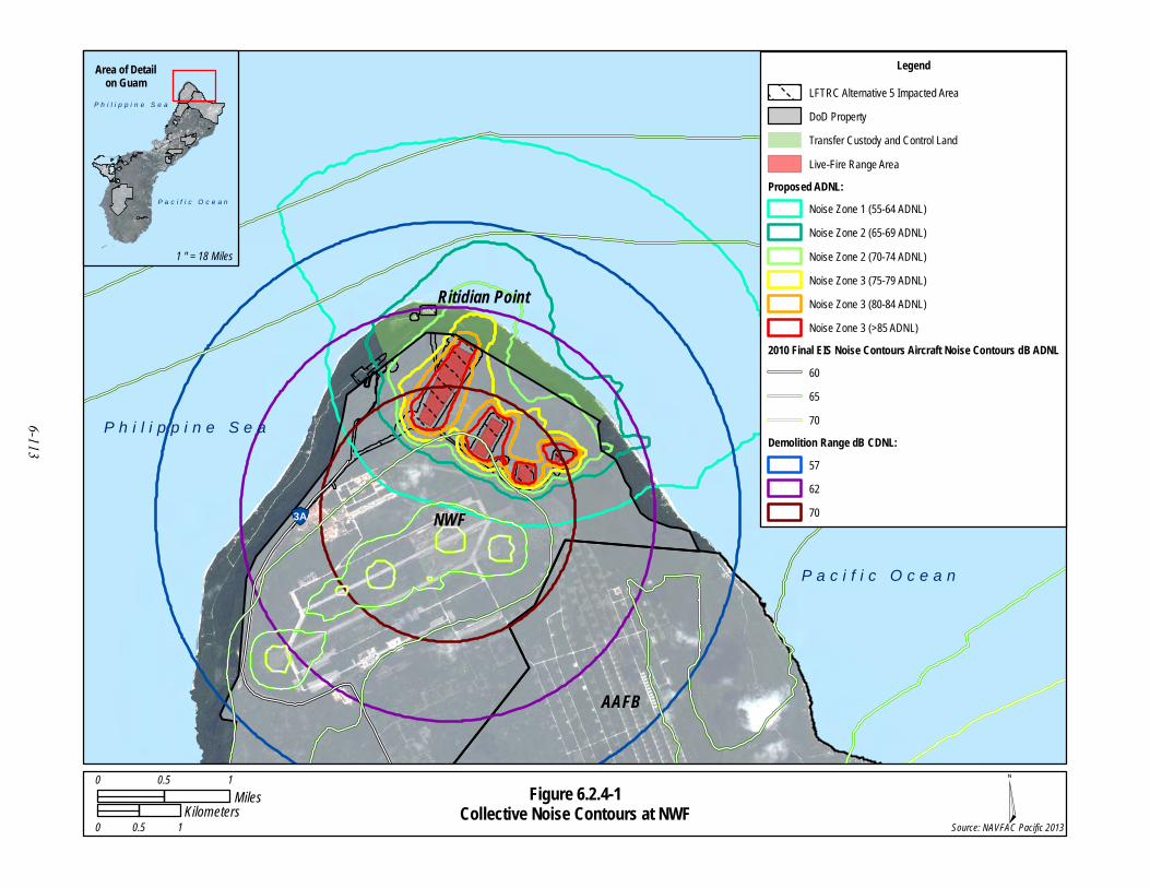
Figure 6.2.4-1Collective Noise Contours at NWF
!"3A
P a c i f i c O c e a n
NWF
Ritidian Point
P h i l i p p i n e S e a
AAFB
¤Source: NAVFAC Pacific 2013
P h i l i p p i n e S e a
P a c i f i c O c e a n
Area of Detailon Guam
1 " = 18 Miles
LegendLFTRC Alternative 5 Impacted AreaDoD PropertyTransfer Custody and Control LandLive-Fire Range Area
Proposed ADNL:Noise Zone 1 (55-64 ADNL)Noise Zone 2 (65-69 ADNL)Noise Zone 2 (70-74 ADNL)Noise Zone 3 (75-79 ADNL)Noise Zone 3 (80-84 ADNL)Noise Zone 3 (>85 ADNL)
2010 Final EIS Noise Contours Aircraft Noise Contours dB ADNL606570
Demolition Range dB CDNL:576270
0 0.5 1Miles
0 0.5 1Kilometers
6-113

Guam and CNMI Military Relocation
(2012 Roadmap Adjustments) SEIS Draft April 2014
6-114
Table 6.2.4-1. Summary of Collective Impacts to Terrestrial Biological Resources by Alternative
Combination of Alternatives
Primary
Limestone
Forest(1)
(acres [ha])
Secondary
Limestone
Forest(1)
(acres [ha])
Overlay
Refuge(1)
(acres [ha])
ESA-Listed
Species(2)
Guam-Listed
Species(2)
Recovery
Habitat
(acres [ha])
Critical
Habitat
(acres [ha])
Finegayan Cantonment/Family Housing
(Alternative A) with Route 15 LFTRC (Alternative
1)
71
(29)
1,232
(499)
1,333
(539)
GMK, GR, MC,
MFB, Ser MS, PSTG
MFB: 1,094 (443)
MC: 1,096 (444)
GR: (878 (355)
GMK: 1,094 (443)
Ser: 758 (307)
NA
Finegayan Cantonment/Family Housing
(Alternative A) with NAVMAG East/West
LFTRC (Alternative 2)
6
(3)
1,061
(429)
1,333
(539)
GMK, GR, MC,
MFB, Ser MS, PSTG
MFB: 1,056 (427)
MC: 1,058 (428)
GR: 644 (261)
GMK: 1,056 (427)
Ser: 709 (287)
NA
Finegayan Cantonment/Family Housing
(Alternative A) with NAVMAG North/South
LFTRC (Alternative 3)
111
(45)
1,106
(448)
1,608
(651)
GMK, GR, MC,
MCM, MFB, Ser MS, PSTG
MFB: 1,236 (500)
MC: 1,245 (504)
GR: 619 (250)
GMK: 1,236 (500)
Ser: 731 (296)
NA
Finegayan Cantonment/Family Housing
(Alternative A) with NAVMAG L-Shaped LFTRC
(Alternative 4)
73 (29) 1,105 (447) 1,552 (628) GMK, GR, MC,
MFB, Ser MS, PSTG
MFB: 1,174 (475)
MC: 1,181 (478)
GR: 645 (261)
GMK: 1,174 (475)
Ser: 710 (287)
NA
Finegayan Cantonment/Family Housing
(Alternative A) with NWF LFTRC (Alternative 5) 96 (40) 1.153 (467) 1,587 (642)
GMK, GR, MC,
MFB, Ser MS, PSTG
MFB: 1,209 (489)
MC: 1,211 (490)
GR: 635 (257)
GMK: 1,209 (489)
Ser: 845 (342)
MFB, MC,
GMK: 12 (5)
Finegayan/South Finegayan Cantonment/Family
Housing (Alternative B) with Route 15 LFTRC
(Alternative 1)
71 (29) 1,062 (430) 1,060 (429) GMK, GR, MC,
MFB, Ser MS, PSTG
MFB: 908 (367)
MC: 909 (368)
GR: 985 (399)
GMK: 908 (367)
Ser: 758 (307)
NA
Finegayan/South Finegayan Cantonment/Family
Housing (Alternative B) with NAVMAG
East/West LFTRC (Alternative 2)
6 (3) 891 (361) 1,060 (429) GMK, GR, MC,
MFB, Ser MS, PSTG
MFB: 870 (352)
MC: 871 (352)
GR: 751 (304)
GMK: 870 (352)
Ser: 709 (287)
NA

Guam and CNMI Military Relocation
(2012 Roadmap Adjustments) SEIS Draft April 2014
6-115
Table 6.2.4-1. Summary of Collective Impacts to Terrestrial Biological Resources by Alternative
Combination of Alternatives
Primary
Limestone
Forest(1)
(acres [ha])
Secondary
Limestone
Forest(1)
(acres [ha])
Overlay
Refuge(1)
(acres [ha])
ESA-Listed
Species(2)
Guam-Listed
Species(2)
Recovery
Habitat
(acres [ha])
Critical
Habitat
(acres [ha])
Finegayan/South Finegayan Cantonment/Family
Housing (Alternative B) with NAVMAG
North/South LFTRC (Alternative 3)
111 (45) 936 (379) 1,335 (540) GMK, GR, MC,
MCM, MFB, Ser MS, PSTG
MFB: 1,050 (425)
MC: 1,058 (428)
GR: 726 (294)
GMK: 1,050 (425)
Ser: 731 (296)
NA
Finegayan/South Finegayan Cantonment/Family
Housing (Alternative B) with NAVMAG L-
Shaped LFTRC (Alternative 4)
73 (29) 935 (378) 1,279 (518) GMK, GR, MC,
MFB, Ser MS, PSTG
MFB: 988 (400)
MC: 994 (402)
GR: 752 (304)
GMK: 988 (400)
Ser: 710 (287)
NA
Finegayan/South Finegayan Cantonment/Family
Housing (Alternative B) with NWF LFTRC
(Alternative 5)
96 (40) 983 (398) 1,314 (532) GMK, GR, MC,
MFB, Ser MS, PSTG
MFB: 1,023 (414)
MC: 1,024 (414)
GR: 742 (300)
GMK: 1,023 (414)
Ser: 845 (342)
MFB, MC,
GMK: 12 (5)
AAFB Cantonment/Family Housing (Alternative
C) with Route 15 LFTRC (Alternative 1) 208 (84) 1,277 (517) 1,002 (405)
GMK, GR, MC,
MFB, Ser -
MFB: 1,308 (529)
MC: 1,311 (530)
GR: 644 (261)
GMK: 1,308 (529)
Ser: 1,228 (497)
NA
AAFB Cantonment/Family Housing (Alternative
C) with NAVMAG East/West LFTRC
(Alternative 2)
143 (58) 1,106 (448) 1,002 (405) GMK, GR, MC,
MCM, MFB, Ser PSTCG
MFB: 1,270 (514)
MC: 1,273 (515)
GR: 410 (166)
GMK: 1,270 (514)
Ser: 1,179 (477)
NA
AAFB Cantonment/Family Housing (Alternative
C) with NAVMAG North/South LFTRC
(Alternative 3)
248 (100) 1,151 (466) 1,277 (517) GMK, GR, MC,
MCM, MFB, Ser PSTG
MFB: 1,450 (587)
MC: 1,460 (591)
GR: 385 (156)
GMK: 1,450 (587)
Ser: 1,201 (486)
NA
AAFB Cantonment/Family Housing (Alternative
C) with NAVMAG L-Shaped LFTRC (Alternative
4)
210 (85) 1,150 (465) 1,221 (494) GMK, GR, MC,
MFB, Ser PSTG
MFB: 1,388 (562)
MC: 1,396 (565)
GR: 411 (166)
GMK: 1,388 (562)
Ser: 1,180 (477)
NA
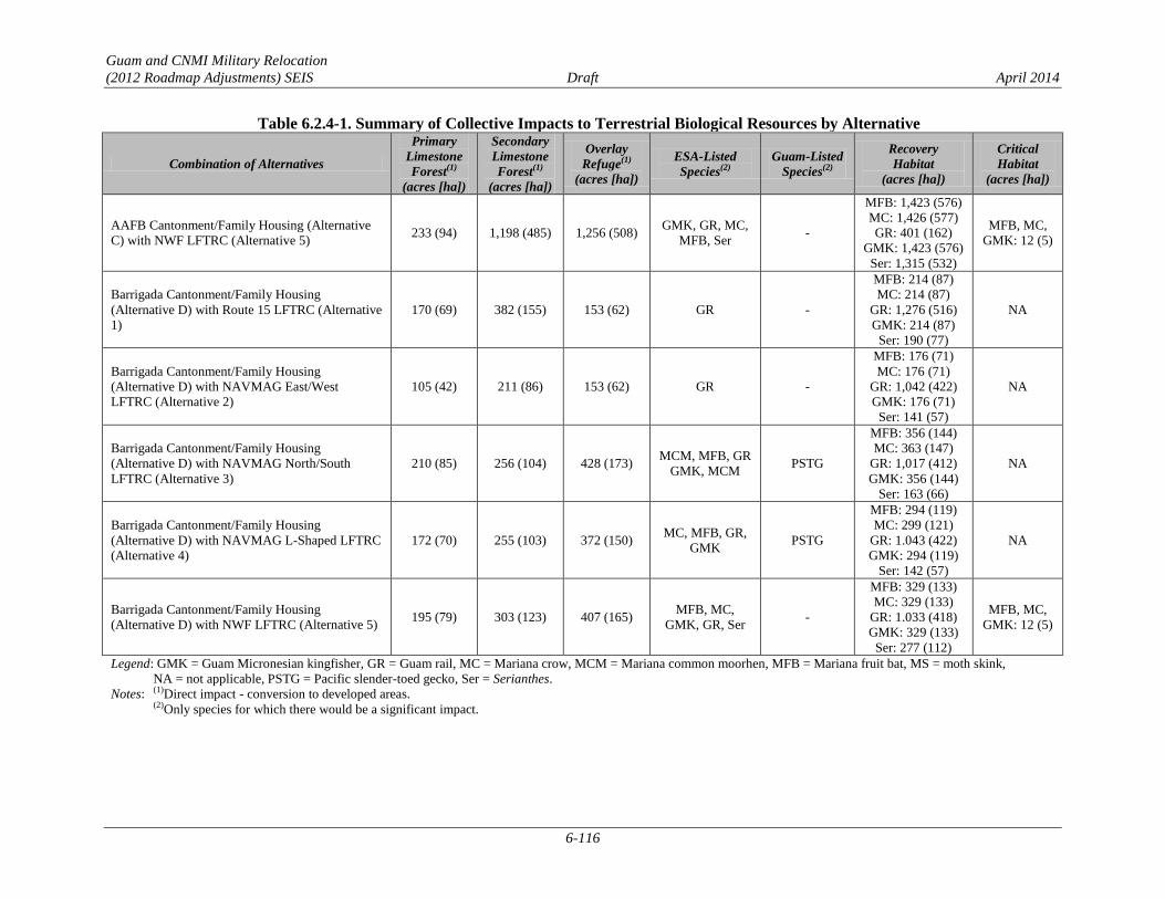
Guam and CNMI Military Relocation
(2012 Roadmap Adjustments) SEIS Draft April 2014
6-116
Table 6.2.4-1. Summary of Collective Impacts to Terrestrial Biological Resources by Alternative
Combination of Alternatives
Primary
Limestone
Forest(1)
(acres [ha])
Secondary
Limestone
Forest(1)
(acres [ha])
Overlay
Refuge(1)
(acres [ha])
ESA-Listed
Species(2)
Guam-Listed
Species(2)
Recovery
Habitat
(acres [ha])
Critical
Habitat
(acres [ha])
AAFB Cantonment/Family Housing (Alternative
C) with NWF LFTRC (Alternative 5) 233 (94) 1,198 (485) 1,256 (508)
GMK, GR, MC,
MFB, Ser -
MFB: 1,423 (576)
MC: 1,426 (577)
GR: 401 (162)
GMK: 1,423 (576)
Ser: 1,315 (532)
MFB, MC,
GMK: 12 (5)
Barrigada Cantonment/Family Housing
(Alternative D) with Route 15 LFTRC (Alternative
1)
170 (69) 382 (155) 153 (62) GR -
MFB: 214 (87)
MC: 214 (87)
GR: 1,276 (516)
GMK: 214 (87)
Ser: 190 (77)
NA
Barrigada Cantonment/Family Housing
(Alternative D) with NAVMAG East/West
LFTRC (Alternative 2)
105 (42) 211 (86) 153 (62) GR -
MFB: 176 (71)
MC: 176 (71)
GR: 1,042 (422)
GMK: 176 (71)
Ser: 141 (57)
NA
Barrigada Cantonment/Family Housing
(Alternative D) with NAVMAG North/South
LFTRC (Alternative 3)
210 (85) 256 (104) 428 (173) MCM, MFB, GR
GMK, MCM PSTG
MFB: 356 (144)
MC: 363 (147)
GR: 1,017 (412)
GMK: 356 (144)
Ser: 163 (66)
NA
Barrigada Cantonment/Family Housing
(Alternative D) with NAVMAG L-Shaped LFTRC
(Alternative 4)
172 (70) 255 (103) 372 (150) MC, MFB, GR,
GMK PSTG
MFB: 294 (119)
MC: 299 (121)
GR: 1.043 (422)
GMK: 294 (119)
Ser: 142 (57)
NA
Barrigada Cantonment/Family Housing
(Alternative D) with NWF LFTRC (Alternative 5) 195 (79) 303 (123) 407 (165)
MFB, MC,
GMK, GR, Ser -
MFB: 329 (133)
MC: 329 (133)
GR: 1.033 (418)
GMK: 329 (133)
Ser: 277 (112)
MFB, MC,
GMK: 12 (5)
Legend: GMK = Guam Micronesian kingfisher, GR = Guam rail, MC = Mariana crow, MCM = Mariana common moorhen, MFB = Mariana fruit bat, MS = moth skink,
NA = not applicable, PSTG = Pacific slender-toed gecko, Ser = Serianthes.
Notes: (1)Direct impact - conversion to developed areas.
(2)Only species for which there would be a significant impact.

Guam and CNMI Military Relocation
(2012 Roadmap Adjustments) SEIS Draft April 2014
6-117
With respect to Overlay Refuge lands, any combination of alternatives that include Alternative A would
have the greatest potential impact. Specifically, Alternative A with Alternative 3 would have the greatest
total impact to Overlay Refuge lands at 1,608 acres (651 ha), or 7% of the lands. Similar to impacts to
limestone forest, any combination of alternatives that include Alternative D would also have the lowest
total impact to limestone forest. Specifically, Alternative D with Alternatives 1 or 2 would have the
lowest impact at 153 acres (62 ha) or <1% of the lands.
All alternative combinations would have significant impacts to ESA-listed special-status species, and only
six alternative combinations would not have significant impacts to Guam-listed special-status species:
Alternatives C or D when combined with Alternatives 1, 2, or 5.
Cultural Resources 6.2.4.3
The collective effects and impacts due to the implementation of the cantonment/family housing
alternatives, LFTRC alternatives, IT/COMM lines, and the 2010 ROD-Related Actions would be equal to
the combined effects and impacts of each. Cultural resources investigations for these actions are discussed
in Sections 6.1, 6.2.1.10, and Chapters 4 and 5. A summary of the collective impact to cultural resources
is provided in Table 6.2.4-2.
The 2011 PA, as discussed in Section 3.10.2, establishes a program alternative for complying with NHPA
Section 106 requirements. For a description of the program alternative for NHPA Section 106 compliance
refer to Section 6.2.1.10 of this chapter.
Table 6.2.4-2. Summary of Cultural Resources Collective Impacts
Alternative Combination Construction Impacts Operation Impacts
Finegayan
Cantonment/Family
Housing (Alternative A)
with Route 15 LFTRC
(Alternative 1)
Potential direct adverse effects to 31
historic properties.
Undetermined effects to 10 unevaluated
buildings.
Undetermined effects to possible buried
cultural resources in unsurveyed areas.
Potential impacts to culturally important
natural resources from vegetation
removal.
Potential indirect adverse effects to 1
historic property from changes in use that
degrade site integrity.
Potential indirect adverse effects to 1
historic property/potential TCP from
recreational use.
Finegayan
Cantonment/Family
Housing (Alternative A)
with NAVMAG East/West
LFTRC (Alternative 2)
Potential direct adverse effects to 37
historic properties.
Undetermined effects to 10 unevaluated
buildings.
Undetermined effects to possible buried
cultural resources in unsurveyed areas.
Potential impacts to culturally important
natural resources from vegetation
removal.
Potential indirect adverse effects to 1
historic property from changes in use that
degrade site integrity and1 historic
property/potential TCP from recreational
use.
Undetermined effects to 3 unevaluated
archaeological sites from changes in use
that degrade site integrity and 1 potential
TCP from additional reduction in
accessibility.
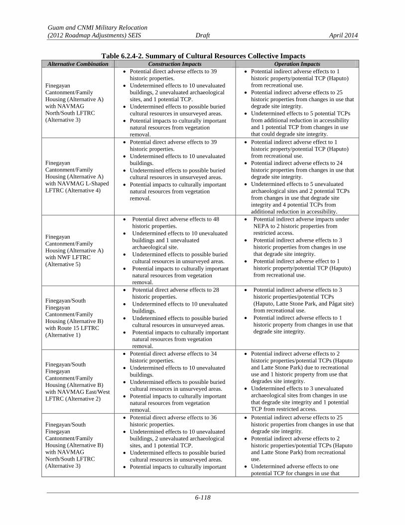
Guam and CNMI Military Relocation
(2012 Roadmap Adjustments) SEIS Draft April 2014
6-118
Table 6.2.4-2. Summary of Cultural Resources Collective Impacts
Alternative Combination Construction Impacts Operation Impacts
Finegayan
Cantonment/Family
Housing (Alternative A)
with NAVMAG
North/South LFTRC
(Alternative 3)
Potential direct adverse effects to 39
historic properties.
Undetermined effects to 10 unevaluated
buildings, 2 unevaluated archaeological
sites, and 1 potential TCP.
Undetermined effects to possible buried
cultural resources in unsurveyed areas.
Potential impacts to culturally important
natural resources from vegetation
removal.
Potential indirect adverse effects to 1
historic property/potential TCP (Haputo)
from recreational use.
Potential indirect adverse effects to 25
historic properties from changes in use that
degrade site integrity.
Undetermined effects to 5 potential TCPs
from additional reduction in accessibility
and 1 potential TCP from changes in use
that could degrade site integrity.
Finegayan
Cantonment/Family
Housing (Alternative A)
with NAVMAG L-Shaped
LFTRC (Alternative 4)
Potential direct adverse effects to 39
historic properties.
Undetermined effects to 10 unevaluated
buildings.
Undetermined effects to possible buried
cultural resources in unsurveyed areas.
Potential impacts to culturally important
natural resources from vegetation
removal.
Potential indirect adverse effect to 1
historic property/potential TCP (Haputo)
from recreational use.
Potential indirect adverse effects to 24
historic properties from changes in use that
degrade site integrity.
Undetermined effects to 5 unevaluated
archaeological sites and 2 potential TCPs
from changes in use that degrade site
integrity and 4 potential TCPs from
additional reduction in accessibility.
Finegayan
Cantonment/Family
Housing (Alternative A)
with NWF LFTRC
(Alternative 5)
Potential direct adverse effects to 48
historic properties.
Undetermined effects to 10 unevaluated
buildings and 1 unevaluated
archaeological site.
Undetermined effects to possible buried
cultural resources in unsurveyed areas.
Potential impacts to culturally important
natural resources from vegetation
removal.
Potential indirect adverse impacts under
NEPA to 2 historic properties from
restricted access.
Potential indirect adverse effects to 3
historic properties from changes in use
that degrade site integrity.
Potential indirect adverse effect to 1
historic property/potential TCP (Haputo)
from recreational use.
Finegayan/South
Finegayan
Cantonment/Family
Housing (Alternative B)
with Route 15 LFTRC
(Alternative 1)
Potential direct adverse effects to 28
historic properties.
Undetermined effects to 10 unevaluated
buildings.
Undetermined effects to possible buried
cultural resources in unsurveyed areas.
Potential impacts to culturally important
natural resources from vegetation
removal.
Potential indirect adverse effects to 3
historic properties/potential TCPs
(Haputo, Latte Stone Park, and Pågat site)
from recreational use.
Potential indirect adverse effects to 1
historic property from changes in use that
degrade site integrity.
Finegayan/South
Finegayan
Cantonment/Family
Housing (Alternative B)
with NAVMAG East/West
LFTRC (Alternative 2)
Potential direct adverse effects to 34
historic properties.
Undetermined effects to 10 unevaluated
buildings.
Undetermined effects to possible buried
cultural resources in unsurveyed areas.
Potential impacts to culturally important
natural resources from vegetation
removal.
Potential indirect adverse effects to 2
historic properties/potential TCPs (Haputo
and Latte Stone Park) due to recreational
use and 1 historic property from use that
degrades site integrity.
Undetermined effects to 3 unevaluated
archaeological sites from changes in use
that degrade site integrity and 1 potential
TCP from restricted access.
Finegayan/South
Finegayan
Cantonment/Family
Housing (Alternative B)
with NAVMAG
North/South LFTRC
(Alternative 3)
Potential direct adverse effects to 36
historic properties.
Undetermined effects to 10 unevaluated
buildings, 2 unevaluated archaeological
sites, and 1 potential TCP.
Undetermined effects to possible buried
cultural resources in unsurveyed areas.
Potential impacts to culturally important
Potential indirect adverse effects to 25
historic properties from changes in use that
degrade site integrity.
Potential indirect adverse effects to 2
historic properties/potential TCPs (Haputo
and Latte Stone Park) from recreational
use.
Undetermined adverse effects to one
potential TCP for changes in use that

Guam and CNMI Military Relocation
(2012 Roadmap Adjustments) SEIS Draft April 2014
6-119
Table 6.2.4-2. Summary of Cultural Resources Collective Impacts
Alternative Combination Construction Impacts Operation Impacts
natural resources from vegetation
removal.
degrade site integrity.
Undetermined effects to 5 potential TCPs
from additional reduction in accessibility.
Finegayan/South
Finegayan
Cantonment/Family
Housing (Alternative B)
with NAVMAG L-Shaped
LFTRC (Alternative 4)
Potential direct adverse effects to 36
historic properties.
Undetermined effects to 10 unevaluated
buildings.
Undetermined effects to possible buried
cultural resources in unsurveyed areas.
Potential impacts to culturally important
natural resources from vegetation
removal.
Potential indirect adverse effects to 2
historic properties/potential TCPs (Haputo
and Latte Stone Park) from recreational
use.
Potential indirect adverse effects to 24
historic properties from changes in use that
degrade site integrity.
Undetermined effects to 4 potential TCPs
from additional reduction in accessibility.
Undetermined effects to 5 unevaluated
archaeological sites and 2 potential TCPs
from changes in use that degrade site
integrity.
Finegayan/South
Finegayan
Cantonment/Family
Housing (Alternative B)
with NWF LFTRC
(Alternative 5)
Potential direct adverse effects to 45
historic properties.
Undetermined effects to 10 unevaluated
buildings and 1 unevaluated
archaeological site.
Undetermined effects to possible buried
cultural resources in unsurveyed areas.
Potential impacts to culturally important
natural resources from vegetation
removal.
Potential indirect adverse impacts under
NEPA to 2 historic properties from
restricted access.
Potential indirect adverse effects to 2
historic properties/potential TCPs (Haputo
and Latte Stone Park) from recreational
use. Potential indirect adverse effects to
three historic properties from changes in
use that degrade site integrity.
AAFB Cantonment/Family
Housing (Alternative C)
with Route 15 LFTRC
(Alternative 1)
Potential direct adverse effects to 27
historic properties.
Potential impacts to culturally important
natural resources from vegetation
removal.
Undetermined effects to 15 unevaluated
buildings.
Undetermined effects to possible buried
cultural resources in unsurveyed areas.
Potential indirect adverse effects to 1
historic property from changes in use that
degrade site integrity.
Potential indirect adverse effects to 1
historic property/potential TCP (Pågat
site) from recreational use.
AAFB Cantonment/Family
Housing (Alternative C)
with NAVMAG East/West
LFTRC (Alternative 2)
Potential direct adverse effects to 34
historic properties.
Potential impacts to culturally important
natural resources from vegetation
removal.
Undetermined effects to possible buried
cultural resources in unsurveyed areas.
Undetermined effects to 15 unevaluated
buildings.
Potential indirect adverse effect to 1
historic property from changes in use that
degrade site integrity.
Undetermined effects to 3 unevaluated
archaeological sites from changes in use
that degrade site integrity.
Undetermined effect to 1 potential TCP
from additional reduction in accessibility.
AAFB Cantonment/Family
Housing (Alternative C)
with NAVMAG
North/South LFTRC
(Alternative 3)
Potential direct adverse effects to 36
historic properties.
Potential impacts to culturally important
natural resources from vegetation
removal.
Undetermined effects to 15 unevaluated
buildings, 2 unevaluated archaeological
sites, and 1 potential TCP.
Undetermined effects to possible buried
cultural resources in unsurveyed areas.
Potential indirect adverse effects to 25
historic properties from changes in use
that degrade site integrity.
Undetermined effects to 1 potential TCP
from changes in use that degrade site
integrity.
Undetermined effects to 5 potential TCPs
from additional reduction in accessibility.
AAFB Cantonment/Family
Housing (Alternative C)
with NAVMAG L-Shaped
Potential direct adverse effects to 36
historic properties.
Undetermined effects to 15 unevaluated
Potential indirect adverse effects to 24
historic properties from changes in use
that degrade site integrity.
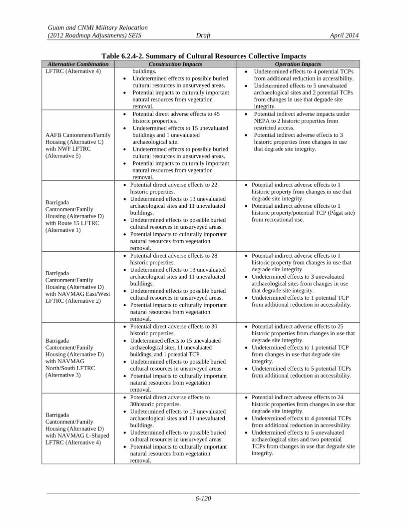
Guam and CNMI Military Relocation
(2012 Roadmap Adjustments) SEIS Draft April 2014
6-120
Table 6.2.4-2. Summary of Cultural Resources Collective Impacts
Alternative Combination Construction Impacts Operation Impacts
LFTRC (Alternative 4) buildings.
Undetermined effects to possible buried
cultural resources in unsurveyed areas.
Potential impacts to culturally important
natural resources from vegetation
removal.
Undetermined effects to 4 potential TCPs
from additional reduction in accessibility.
Undetermined effects to 5 unevaluated
archaeological sites and 2 potential TCPs
from changes in use that degrade site
integrity.
AAFB Cantonment/Family
Housing (Alternative C)
with NWF LFTRC
(Alternative 5)
Potential direct adverse effects to 45
historic properties.
Undetermined effects to 15 unevaluated
buildings and 1 unevaluated
archaeological site.
Undetermined effects to possible buried
cultural resources in unsurveyed areas.
Potential impacts to culturally important
natural resources from vegetation
removal.
Potential indirect adverse impacts under
NEPA to 2 historic properties from
restricted access.
Potential indirect adverse effects to 3
historic properties from changes in use
that degrade site integrity.
Barrigada
Cantonment/Family
Housing (Alternative D)
with Route 15 LFTRC
(Alternative 1)
Potential direct adverse effects to 22
historic properties.
Undetermined effects to 13 unevaluated
archaeological sites and 11 unevaluated
buildings.
Undetermined effects to possible buried
cultural resources in unsurveyed areas.
Potential impacts to culturally important
natural resources from vegetation
removal.
Potential indirect adverse effects to 1
historic property from changes in use that
degrade site integrity.
Potential indirect adverse effects to 1
historic property/potential TCP (Pågat site)
from recreational use.
Barrigada
Cantonment/Family
Housing (Alternative D)
with NAVMAG East/West
LFTRC (Alternative 2)
Potential direct adverse effects to 28
historic properties.
Undetermined effects to 13 unevaluated
archaeological sites and 11 unevaluated
buildings.
Undetermined effects to possible buried
cultural resources in unsurveyed areas.
Potential impacts to culturally important
natural resources from vegetation
removal.
Potential indirect adverse effects to 1
historic property from changes in use that
degrade site integrity.
Undetermined effects to 3 unevaluated
archaeological sites from changes in use
that degrade site integrity.
Undetermined effects to 1 potential TCP
from additional reduction in accessibility.
Barrigada
Cantonment/Family
Housing (Alternative D)
with NAVMAG
North/South LFTRC
(Alternative 3)
Potential direct adverse effects to 30
historic properties.
Undetermined effects to 15 unevaluated
archaeological sites, 11 unevaluated
buildings, and 1 potential TCP.
Undetermined effects to possible buried
cultural resources in unsurveyed areas.
Potential impacts to culturally important
natural resources from vegetation
removal.
Potential indirect adverse effects to 25
historic properties from changes in use that
degrade site integrity.
Undetermined effects to 1 potential TCP
from changes in use that degrade site
integrity.
Undetermined effects to 5 potential TCPs
from additional reduction in accessibility.
Barrigada
Cantonment/Family
Housing (Alternative D)
with NAVMAG L-Shaped
LFTRC (Alternative 4)
Potential direct adverse effects to
30historic properties.
Undetermined effects to 13 unevaluated
archaeological sites and 11 unevaluated
buildings.
Undetermined effects to possible buried
cultural resources in unsurveyed areas.
Potential impacts to culturally important
natural resources from vegetation
removal.
Potential indirect adverse effects to 24
historic properties from changes in use that
degrade site integrity.
Undetermined effects to 4 potential TCPs
from additional reduction in accessibility.
Undetermined effects to 5 unevaluated
archaeological sites and two potential
TCPs from changes in use that degrade site
integrity.
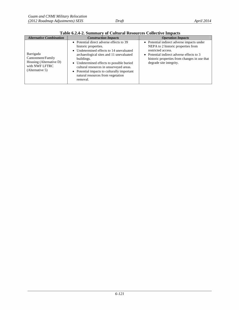
Guam and CNMI Military Relocation
(2012 Roadmap Adjustments) SEIS Draft April 2014
6-121
Table 6.2.4-2. Summary of Cultural Resources Collective Impacts
Alternative Combination Construction Impacts Operation Impacts
Barrigada
Cantonment/Family
Housing (Alternative D)
with NWF LFTRC
(Alternative 5)
Potential direct adverse effects to 39
historic properties.
Undetermined effects to 14 unevaluated
archaeological sites and 11 unevaluated
buildings.
Undetermined effects to possible buried
cultural resources in unsurveyed areas.
Potential impacts to culturally important
natural resources from vegetation
removal.
Potential indirect adverse impacts under
NEPA to 2 historic properties from
restricted access.
Potential indirect adverse effects to 3
historic properties from changes in use that
degrade site integrity.

Guam and CNMI Military Relocation
(2012 Roadmap Adjustments) SEIS Draft April 2014
6-122
This page intentionally left blank.