Chapter 4. Nutrient Reduction in Targeted...
19
Chapter 4. Nutrient Reduction in Targeted Watersheds Six clusters of watersheds were identified in the 2013 strategy as the top group of watersheds in the state for phosphorus control based on stream concentration of phosphorus and modeled phosphorus loads (pounds lost per acre per year). A top group of watersheds was also identified for nitrogen management and a top group for groundwater nitrate concerns. Figure 10: Top Group Watersheds for Phosphorus. 36
Transcript of Chapter 4. Nutrient Reduction in Targeted...

Chapter 4. Nutrient Reduction in Targeted Watersheds
Six clusters of watersheds were identified in the 2013 strategy as the top group of watersheds in the state for phosphorus control based on stream concentration of phosphorus and modeled phosphorus loads (pounds lost per acre per year). A top group of watersheds was also identified for nitrogen management and a top group for groundwater nitrate concerns.
Figure 10: Top Group Watersheds for Phosphorus.
36

Figure 11: Top Group Watersheds for Nitrogen
37
Chapter 4. Nutrient Reduction in Targeted Watersheds

Figure 12: Top Group Watersheds for Drinking/Groundwater
38
Chapter 4. Nutrient Reduction in Targeted Watersheds

4.1 Reducing Phosphorus Loss in Targeted Watersheds – Mississippi River Basin
Rock River Basin
Rock River: TMDL implementation
The Rock River TMDL was published in September 2011. At the same time the TMDL was being developed, DNR was drafting the statewide phosphorus criteria for surface waters in Wisconsin. These criteria are incorporated in WPDES permits and consistent with implementation of the TMDL.
Point Sources
• 88 percent of WPDES point source discharge permit holders in the Rock River Basin have new permits with interim limits. Once P compliance schedules are completed, final TMDL-based WQBELs will take the place of interim limits.
• Remaining permits are being issued as they expire.
• Yahara WINS adaptive management pilot project (see further description below) concluded June 2016. The pilot project was very successful and resulted in the creation of a farmer led group called Yahara Pride, tens of thousands of acres receiving updated nutrient management plans, reducing thousands of pounds of phosphorus runoff to Six Mile Creek, and the development of a Nine Key Element Plan in Dorn Creek. This project has been expanded to a full-scale adaptive management project for the entire Yahara watershed (540 square miles or 16 percent of Rock River Basin) with 23 municipal partners, three county partners and 106,000 lb/yr P reduction target. Project targets, once reached, are projected to exceed TMDL goals.
• Oconomowoc Watershed Protection Project has now been formally filed with DNR and completed its first year of implementation (see further description below). Total combined reductions when fully operational will exceed 4,500 lbs/yr of P.
• Numerous other point sources are actively exploring water quality trading and adaptive management to meet their TMDL limits. For example, Sun Prairie and Edgerton are in discussions with other facilities to combine optimization with trading to meet TMDL limits.
DNR staff have developed a TMDL permitting strategy for permitted MS4 communities to roll out TMDL implementation over three permit cycles. Existing communities have already received the first (general and individual) permit in this cycle for the Rock River Basin. Seven communities were newly identified as needing an MS4 permit, based on 2010 census information and will be expected to comply with TMDL reductions
39
Chapter 4. Nutrient Reduction in Targeted Watersheds
Nonpoint Sources
• The Rock River TMDL includes 10 county partners in NPS implementation. The past three years have focused on working with counties, the Department of Agriculture, Trade and Consumer Protection and numerous watershed partners to develop a workable NPS implementation plan that is also consistent with the USEPA Nine Key Elements. DNR has developed a “county template” for the plan to facilitate implementation and tracking of NPS reductions – consistent with DATCP requirements for county Land & Water Resource Management Plans. Five of the 10 counties, representing a majority of NPS lands in the Rock River Basin, are either utilizing the implementation
plan template, or a similar Nine Key Element watershed planning approach to implement NPS practices consistent with TMDL goals.
• NPS implementation focuses on local control, soil health and water quality, which are interrelated. A tool for recognizing these is the development and support of Farmer-Led Watershed Initiatives/Coalitions (see further description in Chapter 4). There are now two legally recognized groups (Yahara & Oconomowoc), one more being actively formed (Dodge County Soil Health), and three others being developed in Jefferson, Rock and Walworth Counties.
Rock River: Oconomowoc Watershed Protection Program
In 2013, Oconomowoc was informed of its future phosphorus limits and compli-ance schedule to be included in the next WPDES permit to be issued in early 2014 to its 4.0 MGD treatment facility. The esti-mated cost to implement phosphorus controls to meet permit limits for the treatment facility and MS4 was $15 million. The City began to investigate the value of Water Quality Trading and Adaptive Management alternatives, and became aware of problem areas in the watershed and remedial projects taking place in areas upstream of the City. A partnership formed with Tall Pines Conservancy, a nonprofit agency that is heavily involved in land and water conservation efforts in northwest Waukesha County.
By mid-2014, the city had determined that adaptive management (see program description in Chapter 32) would be its method of complying with new phosphorus limits. Oconomowoc submitted its adaptive management application and plan to DNR and simultaneously applied for a Regional Conservation Partnership Program (RCPP) grant from NRCS (see program description in Chapter3) to assist with implementation costs. Both applications were approved in 2015. The Oconomowoc plan identifies phosphorus reductions at the treatment plant (and timeline) but also identifies 79 potential critical source area project sites and associated phosphorus reductions, encompassing more than 1,700 acres. The approval of the adaptive management plan meant the city now had the main
40
Chapter 4. Nutrient Reduction in Targeted Watersheds
tool in hand to fully implement a holistic watershed program to address point and non-point sources of nutrient loading to the entire 49 mile length of the Oconomowoc River. More than 25 partners made up of public and private entities, lake manage-ment districts and local government agen-cies were already signed on as a result of the application process for the RCPP and AMP and the city council had already passed budgets reflecting the anticipated costs of the program. With the adaptive manage-ment plan approach, it is anticipated the city and utility will save in total, $10 to $12 million over the next 15 years.
By the end of 2015, boots on the ground efforts were being deployed to educate local governments and land owners and coordinate potential projects in conjunction with the NRCS. By early 2016, the Ocono-mowoc Watershed Protection Program was conducting its second round of farmer education meetings. A farmer leadership group was formed consisting of five well respected producers from various locations in the watershed. This group has provided a wealth of knowledge and has given valu-able testimony at outreach meetings. In June of this year the Oconomowoc project, in conjunction with its three main partners, Tall Pines Conservancy; Ruekert and Mielke; and the Clean Water Association put on the group’s first Healthy Lakes Conference. This conference was geared toward shoreline management, lake water quality, the lake association membership and involvement in the Oconomowoc project.
Monitoring is a major component of the Oconomowoc effort and city staff and volunteers are sampling at more than 30
locations throughout the watershed. Offi-cial monitoring required by the adaptive management program is done once per month from May through October, and event monitoring is completed whenever possible during or after significant rainfall or snow melt. The data collected during the last two years has been extremely valuable and has confirmed some initial assumptions but has also exposed problem areas that were not expected. The city will be evaluated for compliance with the adaptive management program at Site #18 located just upstream of the confluence with the Rock River. By the beginning of the third WPDES permit term, (approximately 2027) the value of total phosphorus at this location must be at or below 0.075 mg/l based on a five-year statistical average. The Oconomowoc water-shed monitoring effort will be enhanced by the fall of 2016 when five flow monitoring stations are installed at strategic locations on the Oconomowoc River through an agreement with Sand County Foundation, one of the program partners. This effort will provide valuable information on the mass of phosphorus moving through key points along the Oconomowoc River and through some of the larger lakes.
41
Chapter 4. Nutrient Reduction in Targeted Watersheds
Rock River: Yahara WINs – Adaptive Management in the Yahara River Basin
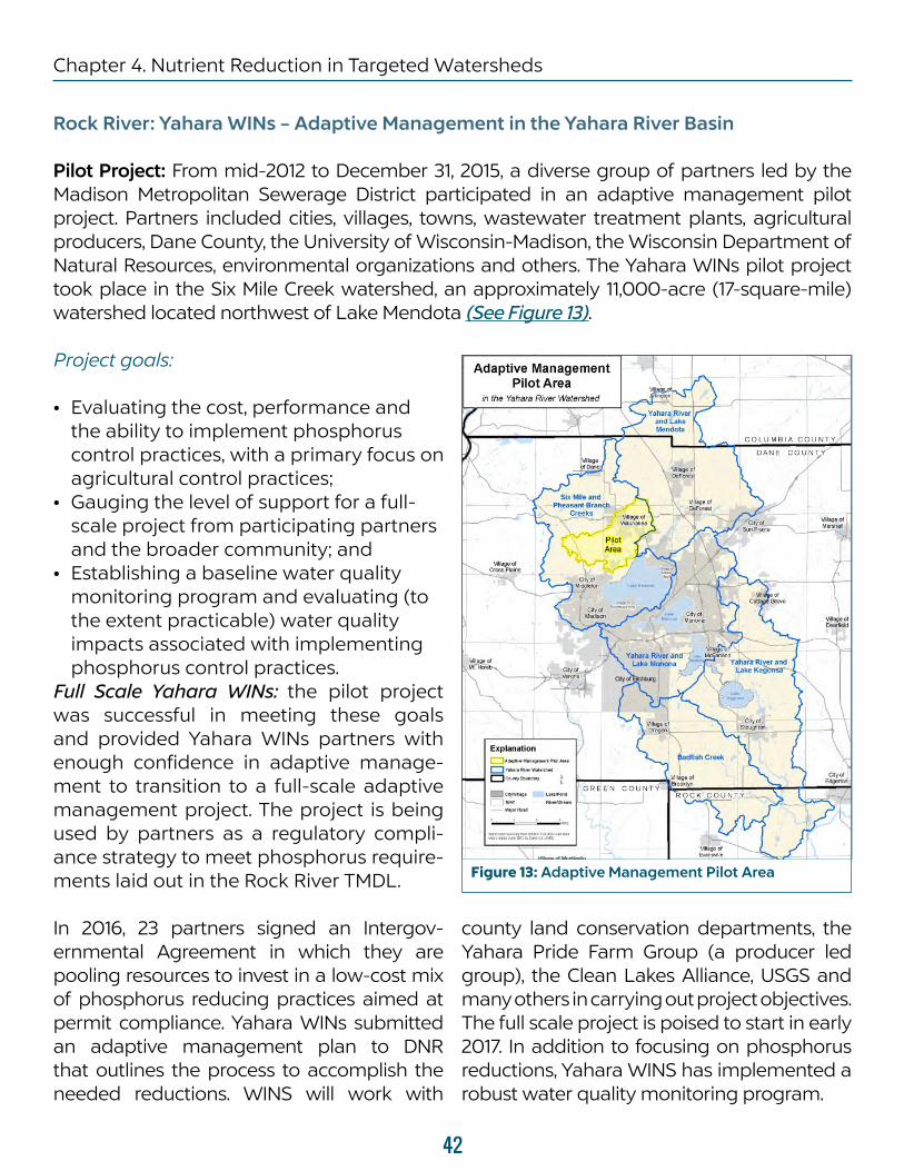
Pilot Project: From mid-2012 to December 31, 2015, a diverse group of partners led by the Madison Metropolitan Sewerage District participated in an adaptive management pilot project. Partners included cities, villages, towns, wastewater treatment plants, agricultural producers, Dane County, the University of Wisconsin-Madison, the Wisconsin Department of Natural Resources, environmental organizations and others. The Yahara WINs pilot project took place in the Six Mile Creek watershed, an approximately 11,000-acre (17-square-mile) watershed located northwest of Lake Mendota (See Figure 13).
Project goals:
• Evaluating the cost, performance and the ability to implement phosphorus control practices, with a primary focus on agricultural control practices;
• Gauging the level of support for a full-scale project from participating partners and the broader community; and
• Establishing a baseline water quality monitoring program and evaluating (to the extent practicable) water quality impacts associated with implementing phosphorus control practices.
Full Scale Yahara WINs: the pilot project was successful in meeting these goals and provided Yahara WINs partners with enough confidence in adaptive manage-ment to transition to a full-scale adaptive management project. The project is being used by partners as a regulatory compli-ance strategy to meet phosphorus require-ments laid out in the Rock River TMDL.
In 2016, 23 partners signed an Intergov-ernmental Agreement in which they are pooling resources to invest in a low-cost mix of phosphorus reducing practices aimed at permit compliance. Yahara WINs submitted an adaptive management plan to DNR that outlines the process to accomplish the needed reductions. WINS will work with
county land conservation departments, the Yahara Pride Farm Group (a producer led group), the Clean Lakes Alliance, USGS and many others in carrying out project objectives. The full scale project is poised to start in early 2017. In addition to focusing on phosphorus reductions, Yahara WINS has implemented a robust water quality monitoring program.
Figure 13: Adaptive Management Pilot Area
42
Chapter 4. Nutrient Reduction in Targeted Watersheds

The intergovernmental agreement; pilot project report and draft Adaptive Manage-ment Plan as well as additional information are available on the Yahara WINS portion of the Madison Metropolitan Sewerage
District website (http://www.madsewer.org/Programs-Initiatives/Yahara-WINs) The plan has been approved by DNR and will be incorporated into MMSD’s WPDES permit upon permit reissuance in 2017.
Rock River: 2015 Yahara Pride Farms Outcomes
Yahara Pride Farms combines a diverse set of partners including the Clean Lakes Alli-ance, the Madison Metropolitan Sewerage District, the Natural Resource Conserva-tion Service, UW-Extension Dane County and more than 20 other agribusiness and cooperative organizations. To increase the use of conservation practices in the water-shed, Yahara Pride Farms provides a cost-share program. The goal of the cost-share program is to allow farmers the opportu-nity to test new, innovative technologies at a minimized risk, in hopes that farmers will see the benefits from the technology and incorporate the practice into their standard operations.
In 2015, farmers in the program documented the adoption of practices that reduced phosphorus delivery to the Madison chain of lakes and the Yahara River by 8,642 lbs.
Since 2012, farmers have documented a total phosphorus delivery reduction of 15,872 lbs. Documented practices include: cover crops, strip tillage, low disturbance manure injection, manure composting and low disturbance deep tillage. New data shows the promise of even greater reduc-tions if practices are combined (known as stacking practices) and when practices are used for several years in a row.
Agriculture is vast in Dane County and the ability to impact clean water is more cost effective than some of the other viable options including storm water and waste water treatment. Across the state, farmers and municipalities alike are taking note of the successes of Yahara Pride Farms and working to replicate aspects of the program. Yahara Pride Farms is also gaining traction on a national level.
Rock River: Dredging of Legacy Sediments
Dane County is proposing to invest $12 million over the next four years to remove 870,000 pounds of phosphorus in 33 miles of streams leading to county lakes. Years of accumulated sediment at the bottom of these streams may be leaching phos-phorus into Dane County lakes. A coun-ty-funded study found that if the sediment is not removed, it will take 99 years to get a 50 percent reduction in phosphorus. The
first phase of the project will remove sedi-ment in 2.3 miles of Dorn Creek, located northwest of Lake Mendota. Next phases of the project expand dredging to 30 miles of the Yahara Watershed, including Cherokee Marsh, Token, Six Mile, Dorr and Nine Springs creeks. Monitoring of water quality and biology will also be conducted at each stage of this pilot effort to gauge effectiveness.
43
Chapter 4. Nutrient Reduction in Targeted Watersheds

Grant-Platte WatershedsOf the 13 active point sources in the Grant-Platte, 11 have WQBELs for phosphorus. That means 85 percent of
dischargers have WQBELS and one has the technology standard of 1.0 mg/L.
Pecatonica – Sugar Watersheds
Green County Land and Water Conser-vation and the NRCS have been making a concerted effort to roll-out cover-crop, soil health and minimum/no-till educa-tion efforts across the Sugar and Peca-tonica River Basin in Green County. They’ve conducted four field demonstration visits in 2016 and four in 2015. Events have been well attended/received with participation by producers, agronomists, and agricul-tural retailers. Specifically within the Sugar River Watershed, the majority of producers is now using cover crops, residue manage-ment and reduced tillage systems. UW-Ex-tension also conducts annual workshops on nutrient management and optimization. Working in concert with UW-Extension and DNR, a Sugar River producer-led soil health initiative has been developed. Twelve producers have agreed to participate and are part of a committee to plan a produc-er-led soil health and water quality event for 2017. Many of these producers have already adopted advanced sustainable ag practices, such as no-till and manure injec-tion and are committed to furthering the use of these practices across the watershed. For example, one of the members is one of the largest cash-grain operations in Green County – farming more than 2,500 acres no-till, for more than 20 years. A second member milks 450 cows and works 1,200 acres with extensive soil building practices, manure management and cover cropping
to restore soil health on depleted fields he has been acquiring from closing farms in the area. Two other producers also happen to be CAFOs and implement innovate manure handling practices including solids separation for bedding, sand reclamation, precision ag, cover crops and manure injec-tion. These producers represent some of the most productive and respected farmers in the region and, working together, they have committed to further the soil health move-ment across the Sugar River watershed.
In order to address phosphorus, two WPDES permitted communities (Brooklyn and Brodhead) have chosen water quality trading as their permit compliance option. Both communities desire to work with local producers to recognize significant point and NPS reductions in phosphorus and TSS loading to the Sugar River. Grande Cheese in Juda is also considering water quality trading as the company’s food/industrial WPDES permit compliance option and is considering a combination of land appli-cation and sustainable ag practice agree-ments to meet load reductions.
A Sugar River Watershed conference was held in April by the Lower Sugar River Water-shed Association and a number of other partners. The event was attended by agency, community, farmers/producers and students and featured presentations on water quality,
44
Chapter 4. Nutrient Reduction in Targeted Watersheds

soil health, point source pollution and aquatic ecosystems. Attendees represented both the Sugar and Pecatonica watersheds.
In the Pecatonica watershed, DNR hosted a series of nutrient reduction workshops in 2015/2016 and worked closely with WPDES permitted communities to explore and encourage the exploration of adaptive management and water quality trading
for permit compliance. The communities of Hollandale, Argyle, Blanchardville, and Barnevald have expressed a desire to potentially partner in a large-scale Peca-tonica Watershed Water Quality Trading Project and work jointly to develop practices to meet point source pollution reduction requirements. DNR wastewater staff are working with the communities to facilitate permitting.
Pleasant Valley Watershed
The Nature Conservancy/Wisconsin is working with farmers to test a new approach to improving water quality in Wisconsin’s lakes and rivers. The results of a nine-year effort to improve water quality in a tributary of the Pecatonica River in Dane and Green counties in southwest Wisconsin shows that targeting the application of conserva-tion practices on agricultural lands with the highest estimated phosphorus runoff to streams, rather than randomly throughout a watershed, will result in cleaner water.
Water quality monitoring data, following a three-year implementation period, show a 55 percent decrease in phosphorus loading in the test watershed. These results are the result of the conservation practices that farmers put into place. With 95 percent confidence this result is statistically significant. Similarly, the reduction in phosphorus concentration was
also significant. These results were obtained through the use of a paired watershed study using a test and a control watershed. The project focused on 11 farmers with fields and pastures with the highest estimated runoff phosphorus losses during storm events. Farmers who changed their management practices reduced both their estimated phos-phorus and sediment losses by about half, keeping an estimated average 4,400 pounds of phosphorus and 1,300 tons of sediment out of the water each year.
Another way to think about the reduction in phosphorus loading is that on a warm spring day with steady rainfall, if there would have been 500 pounds of phos-phorus run-off without the project, after farmers put conservation practices in place on targeted fields and pastures there would only be 225 pounds.”
Headwaters Big Eau Pleine, Black and Eau Claire River
These are included as part of the Wisconsin River TMDL, see Chapter 5 for further description.
45
Chapter 4. Nutrient Reduction in Targeted Watersheds

Reducing Phosphorus Loss in Targeted Watersheds – Lake Michigan Basin
Lake Michigan: Lower Fox River Basin
The Lower Fox River Basin, located between Lake Winnebago and Green Bay, is one of the highest priority watersheds in the Great Lakes Basin as well as having one of the first basin-wide Total Maximum Daily Load plans (TMDLs) for phosphorus. Implementation activities have received federal funding from the USDA Natural Resources Conservation Service (NRCS) and from the US Environmental Protection Agency’s Great Lakes Resto-ration Initiative (GLRI), as well as state funding.
Key activities:
• TMDL Implementation • Lower Fox Demonstration Farms • Plum-Kankapot GLRI Project
• Fox P Trade • Nine Key Element Watershed Plans • The Lower Green Bay & Fox River AOC
TMDL Implementation
EPA approved the Lower Fox TMDL for phosphorus on May 18, 2012. Point source reductions of 107,595 pounds P per year will occur when all WPDES permits are reissued and all reduction actions are fully implemented. Currently, nine of the 30 total permits have been reissued, with an additional 12 expected to be reissued by mid-2017. Remaining permits will be re-issued as they expire. Municipal sepa-rate storm sewer systems (MS4s) in 29 municipalities received coverage under the WPDES general permit in May 2014. Full implementation will reduce 21,058 pounds P per year.
• Both TSS and TP loading reductions in the Lower Fox TMDL area continue to be pursued by permitted MS4s in 2015 and 2016. The department has supported those efforts through urban nonpoint source construction grants on
construction of five new regional ponds, one streambank stabilization project and one purchase of a high-efficiency street sweeper. The focus of TMDL-related MS4 permittee efforts during the current five year permit term is on assessment and planning. Many of the communities have either recently completed or are in the process of completing community-wide pollutant modeling to estimate pollutant reductions achieved within the TMDL watersheds and identify locations for new structural best management practices to be installed in the future. The department is providing cost-share dollars through the urban nonpoint source planning grant program for five permitted MS4’s in the Lower Fox TMDL.
• The Heart of the Valley MSD has submitted the first water quality trading plan (see Chapter 3 for description of trading) within a TMDL area in the
46
Chapter 4. Nutrient Reduction in Targeted Watersheds

state. Heart of the Valley is a major municipal wastewater treatment facility discharging to the Lower Fox River. Heart of the Valley is working to install a detention basin to precipitate TSS
and TP out of agricultural runoff from cropland in a predominately dairy crop rotation before the runoff can enter the Lower Fox River. TSS and TP credits will be generated from this practice.
Lower Fox Demonstration Farms
The USDA Natural Resources Conservation Service (NRCS) and the Great Lakes Commis-sion (GLC) partnered to establish a Great Lakes Demonstration Farm Network, the first of its kind in Wisconsin. Other partners include the Brown County Land & Water Conserva-tion Department and Outagamie County Land Conservation Department. The network is working to provide better information on the effectiveness of conservation systems used to improve water quality. The participating farms demonstrate effectiveness and adapt-ability of conservation practice systems to reduce erosion and sedimentation, control phosphorus runoff and address other nonpoint source pollution issues. The network also provides educational technology transfer opportunities for the public, farmers, land managers, agribusiness, environmental organizations, natural resource agencies and research entities and their partners.
The Demonstration Farm Network objectives are to:
• establish demonstration farms within the Lower Fox Watershed to test new and standard conservation systems in reducing phosphorus and sediment;
• establish an efficient mechanism to share this technology and information with farmers, agribusiness, conservation agencies and the public;
• create opportunities for others to test their research, technical and program ideas at the demonstration farms; and
• share information and lessons learned from the Lower Fox Watershed throughout the Great Lakes basin.
The four farms participating in the Network are Brickstead Dairy, operated by Dan Brick; Nettekoven Farms, operated by Greg and Karon Nettekoven; Tinedale Cropping, oper-ated by Scott Theunis and family; and Van Wychen Farms, operated by George Van Wychen and his son Nick. Each of these farms has played an intricate role in trying, demonstrating and sharing information about leading-edge practices and technolo-gies applied on their farms. Practices include cover crops, reduced tillage, reduced-dis-turbance manure application, pesticide management and water quality monitoring.
47
Chapter 4. Nutrient Reduction in Targeted Watersheds
Plum-Kankapot GLRI Project
The Fox-Wolf Watershed Alliance was awarded a $4.2 million Great Lakes Resto-ration Initiative (GLRI) Grant from U.S. EPA in March of 2015 to begin implementation of a watershed recovery effort for the Lower Fox River over the next five years. The Plum and Kankapot sub-watersheds were iden-tified as the highest loading sediment and phosphorus watersheds to the Lower Fox River per agricultural acre. The project team will work with producers in the Plum and Kankapot Creek sub-watersheds to reduce sediment and phosphorus runoff.
Partners in the project include: Outagamie County and Brown County Land Conserva-tion Departments, the Nature Conservancy, University of Wisconsin - Green Bay and the Great Lakes Commission.
The funding will give Land Conservation Department staff the ability to offer finan-cial assistance to farmers to install land conservation best management practices that work towards keeping the soil in place. Practices such as cover crops, streambank protection, stream buffering, concen-trated flow area seeding and agricultural treatment wetlands are being promoted and installed throughout the watershed. Funding for equipment to showcase and allow producers to test on their own farms
was also included as a part of the project. In 2015, a vertical till manure injector was purchased and used throughout the Plum and Kankapot Watershed. This equipment has sparked the interest amongproducers in the Plum Creek and Kanakpot Creek subwatershed, but throughout the Lower Fox River Basin. A private hauler has since purchased his own injector.
Staff from the UW-Green Bay (UWGB) Department of Natural and Applied Sciences in cooperation with the US Geolog-ical Survey Wisconsin Water Science Center will conduct water quality monitoring activities and investigate data associated with sediment reduction strategies in Plum and Kankapot Creek sub-watersheds. Two subwatersheds, Plum and West Plum, will be compared using existing data as the baseline period. After the land conservation best management practices (BMPs) are installed in the Plum Creek subwatershed, the pre- and post- treatment relationships between the control and treated water-sheds will then be compared. UWGB and the USGS are also conducting edge-of-field monitoring to determine the effectiveness of the practices in controlling sediment runoff as well as monitoring the effective-ness of small treatment wetlands installed as part of the project.
48
Chapter 4. Nutrient Reduction in Targeted Watersheds
Fox P Trade
The Fox P Trade project has continued to test the Wisconsin water quality trading guidance (adopted in 2013) as it applies in the Fox River Watershed, which is subject to a TMDL. This 3.5 year project is scheduled to end September 30, 2016. Templates for documents to support phosphorus credit trading have been developed and tested through hypothetical trades. Workshops and webinars were held throughout to share progress, teach stakeholders about water quality trading and gain feedback on key elements of a trading program. Through these activities, the project built consensus around recommended ways to structure the trading market, and which entities are best suited to perform key roles, such as credit certification, practice veri-fication, and brokering trades. Additional details about the project are on the Great Lakes Commission’s web site at http://glc.org/projects/water-quality/foxptrade/
In October 2016, the project culminated with a pilot phosphorus trade agreement between NEW Water (Green Bay Metro-politan Sewerage District) and Bob Van De
Loo and Sons Inc. of Kakauna, in Outag-amie County. In the agreement, the farmer will be compensated by NEW Water for the use of cover crops, conservation tillage and buffers. A portion of the pounds of phosphorus reduced from the farm will be credited for trading. While this initial trade is not necessary for NEW Water to be compliance with its current Wisconsin Pollutant Discharge Elimination System permit, it lays the groundwork for trading as a future compliance option and demon-strates the process of how trading works in a TMDL watershed. To this end, the project has been a valuable exercise in assisting the stakeholders in the watershed as well as the Wisconsin Department of Natural Resources to better understand the various issues that arise as the guidance is imple-mented in impaired watersheds. A trading handbook and interactive web-based trading portal (www.foxptrade.org) tailored to this watershed are key final products. The Great Lakes Commission looks forward to seeing the trading in the Lower Fox River Watershed live on under the guidance of the local Fox-Wolf Watershed Alliance.
49
Chapter 4. Nutrient Reduction in Targeted Watersheds

Nine Key Element Watershed Plans
DNR completed review and issued approval of Nine Element watershed plans for the Upper East River watershed and Upper Duck Creek watershed plans in 2016. The East River, Duck and Plum/Kankapot water-sheds have been identified via water quality monitoring and Lower Fox TMDL calcula-tions, as three of the largest sediment and P loading areas to the Lower Fox River (listed as impaired for phosphorus and sediment).
The Upper East River and Upper Duck plans use the same approach as the Plum/Kankapot plan by using DNR and EPA modeling tools – EVAAL and STEPL – to identify priority areas and model pollutant reductions from a combination of various practices in order to address the Nine Key Elements and Lower Fox TMDL reduction goals. The plans also rely upon existing or new water quality monitoring stations at the mouth of each of these watersheds to confirm if practices (and modeled reduc-tions) implemented result or do not result in improved water quality.
All three plans have 10 year schedules and contain milestones that reflect real-istic landowner participation rates and implementation of various practices on 75 percent of cropland acres in each water-shed. Because of this, the plans explain they will make substantial progress towards, but fall short of, meeting overall Lower Fox
TMDL P reduction goals. To meet the Nine Key Elements, each plan explains addi-tional practices or new technologies to meet the remaining TMDL P and sediment reductions that are predicted, via SWAT modeling, to restore impaired waters in the basin. The plans represent current exam-ples of the overall Lower Fox TMDL imple-mentation plan strategy. Additional Nine Key Element watershed plans are expected to be developed for other Lower Fox river subwatersheds in the next two years.
In addition to NineKey Element plans, DNR initiated a new project to further assist with Lower Fox TMDL implementation. The new project will define Lower Fox TMDL base-line conditions for multiple sub-basins within the Lower Fox River watershed by incorporating the Lower Fox TMDL SWAT model assumptions for NPS Agriculture into Wisconsin’s SNAP+ model. Once complete, the SNAP+ model sub-basin outputs will help explain (in a language that agricul-ture understands) how the Lower Fox TMDL NPS reductions apply to croplands and pastures on either a field or farm wide basis. Currently, the SWAT model TMDL reductions are difficult to apply/interpret on these scales. Using SNAP+ model outputs will help DNR, county, farmers and consul-tants determine what NPS practices and reductions are ne to meet TMDL reductions
50
Chapter 4. Nutrient Reduction in Targeted Watersheds

The Lower Green Bay & Fox River AOC
Great Lakes rivers and harbors that have been most severely affected by historical pollution and habitat loss are considered “Areas of Concern,” or AOCs. Designated in 1987 under an international agreement between the U.S. and Canada known as the Great Lakes Water Quality Agreement, these sites need special attention for restoration and cleanup. The Lower Green Bay/Fox River is one of Wiscon-sin’s five designated AOCs. It is impaired for “Eutrophication or Undesirable Algae,” one of 14 possible impairments listed in the Great Lakes Water Quality Agreement (it is considered impaired for 13 of the possible 14 impairments overall). Wisconsin is exploring ways that the AOC program can address this impairment while acknowledging the scope of the program, which focuses on defined
geographic areas and legacy pollutants. Given the scope and complexity of the eutrophica-tion issue, the AOC program aims to comple-ment and support efforts that are underway through other programs and initiatives.
DNR has been working with partners and stakeholders to refine the outcomes that will define success for the AOC program for the “eutrophication or undesirable algae” impairment as well as to establish the types of actions that AOC GLRI funds can support. Together, these will set the stage for the AOC to contribute a defined amount of conservation practice implementation to reduce nutrient loading to the Lower Fox River and Lower Green Bay.
Lake Michigan: Manitowoc-Sheboygan River Basins
The Nature Conservancy/Wisconsin is leading a project in the Sheboygan River watershed that mirrors the approach used in the Peca-tonica River watershed. In 2013, work began with farmers to implement conservation practices designed to reduce phosphorus runoff from the targeted fields. Through the summer of 2016, changes to farming prac-tices were implemented and the impacts on water quality were measured in Otter Creek, the test watershed. In this project, 10 farmers with fields with the highest phosphorus index values made changes to improve conser-vation on their farms. Through the project there are 1,710 acres of nutrient management plans, 6 grass buffers, four grass waterways, a bioreactor, 60 acres of conservation tillage, and pasture fencing and milk house system on a dairy that focuses on grazing. The Nature
Conservancy will continue to track water quality with USGS monitoring stations at the mouth of the two small watersheds (HUC 14).
In 2015, this work was expanded to the Mullet River, another tributary of the Sheboygan River. The city of Plymouth is located on this river. This city has a wastewater treatment plant discharging treated water into the river. Like hundreds of cities across Wisconsin, Plymouth will take a serious look at the feasibility of providing funding to farmers to change practices on their farms to avoid large capital costs with advanced treatment needs. The Nature Conservancy has worked with two farmers with incentive funding for the construction of a manure pit and nutrient management planning. On the second farm a grassed waterway was installed.
51
Chapter 4. Nutrient Reduction in Targeted Watersheds
Reducing Nitrate in Groundwater
Nitrate Demonstration Initiative
DNR Bureau of Drinking Water and Groundwater is conducting pilot projects to target groundwater watersheds where public water systems are experiencing rising nitrate trends as a result of nonpoint contributions. Known as the Nitrate Demonstration Project, pilot projects have been initiated in three separate communities: the village of Spring Green; village of Fall Creek; and the city of Waupaca. These projects serve as “problem focus areas,” as each of them have community water systems with nitrate trends above 5 mg/L and approaching the maximum contaminant level of 10 mg/L. The objective is to demonstrate methods and ultimately create a set of decision support tools, to enable communities and landowners to protect and improve source water quality by optimizing nitrogen management practices.
The process starts with an assessment of individual wellhead vulnerability to nitrate impacts, consideration of refinements to existing delineations of source water protection areas where necessary and assessment of existing nitrogen management practices with a view toward opportunities to increase nutrient utilization efficiency and reduce losses to groundwater. Addi-tionally, data is being collected to: 1) assess water quality changes on the basis of improved management practices; and 2) to improve methods to evaluate the potential water quality benefits of management practices, including nitrogen budgeting (mass balance) and the use of process based agro-ecosystem modeling for the purpose of nitrogen management scenario testing. Agreements to significantly modify nitrogen management in order to achieve water quality benefits are developed using voluntary, incentive-based mechanisms.
Accomplishments to date:
• Statewide assessment of all subwatersheds (groundwater nitrate condition, sensitive drinking water receptors, wastewater discharge collaboration opportunities, hydrogeologic data and flow model availability).
• Development of a monitoring and modeling scope of work and identification of partner capacity. See “Nitrate Transport Monitoring Scope _ Draft 6-5-13”
• Identification of geographic priority areas through application of Selection Criteria.
• Recruitment of the village of Spring Green, village of Fall Creek and the
city of Waupaca to participate in comprehensive pilot projects.
• Landowner recruitment (cooperating farmers) in each pilot demonstration area.
• Agreements with landowners and municipalities concerning regulatory assurance and confidentiality of sensitive producer records.
• Evaluation of wellhead protection area delineations for priority areas.
• Installation of local hydrogeologic characterization and a field-edge nitrate flux monitoring system in Spring Green.
• Commencement of detailed wellhead
52
Chapter 4. Nutrient Reduction in Targeted Watersheds
vulnerability assessment work in Waupaca, Spring Green and Fall Creek.
• Successful application of frequent interval, low cost monitoring techniques for measuring nitrate mass flux using supply wells as integrative monitoring wells.
• Contract for evaluation and adaptation
of an agro-ecosystem model for use in demonstration areas.
• Baseline nitrogen management data for three demonstration areas; for estimation of nitrate loading to groundwater by use of nitrogen budget methods; and for calibration of the agro-ecosystem models.
Steps planned for FFY2017 include:
• Additional agricultural producer and landowner recruitment (tailored methods based on producer advice and UW-Extension proposed value-add services to encourage participation).
• Continued data collection on groundwater quality, nitrogen management in agricultural production and parameters related to nitrate fate and transport.
• Groundwater modeling to better define volumetric recharge areas, nitrate loading tolerance of supply well and guide design of long term wellhead protection area nitrogen management.
• Testing of crop system and leaching models (agro-ecosystem), comparison with monitored groundwater conditions and comparison of other nitrogen
management and crop system methodologies
• Continued development of site-specific nitrogen management systems to achieve wellhead protection goals.
• Data collection and initial algorithm development for in-season crop sensing tools to aid nitrogen application timing and rate for corn.
• Begin economic analysis scoping and decision support tool development to compare cost of providing drinking water that meets nitrate standards by water supply infrastructure (new well or treatment system) verses incentivized implementation of nitrogen management practices within wellhead protection areas.
53
Chapter 4. Nutrient Reduction in Targeted Watersheds

Addressing Groundwater Issues in Kewaunee County and Other Susceptible Areas
Kewaunee County contains areas known as “karst,” where fractured bedrock creates conduits for pollutants (nitrates, pathogens) tp move from the surface to the ground-water. These pollutants can, in turn, be taken up in water wells, causing the water to be unsafe for drinking and other household uses. Kewaunee and Door Counties have areas where the soil depth over the karst geology is thin, creating increased risk of groundwater and well contamination. Sources of these pollutants may be from agricultural fields or septic systems. Wells constructed with inadequate casing may also be more susceptible to contamination. Public concern about contaminated wells in Kewaunee County led DNR along with other agencies and stakeholders to work together during 2015/2016 to develop recommendations for reducing the risk of groundwater contamination. The final report was issued in June 2016.
Wisconsin DNR has implemented a number of the work group recommendations including: • Implementing field audits of manure
spreading practices; • Reallocating four staff to the CAFO
permitting program (further resource enhancements may be considered for the FY2017-19 state budget;
• Revising emergency manure spreading guidance;
• Holding an informational meeting with Kewaunee County citizens regarding the recommendations; and
• Providing area farmers with recommended revised manure spreading practices.
Other recommendations in the process of implementation include reviewing and revising well contamination investigations, clarifying eligibility and process for supplying emergency drinking water, improving response coordination to contamination events between local governments and the state, and providing increased consistency in compliance activities.
In addition, Wisconsin DNR is in the process of implementing many more of the recommendations through revising the administrative rule that establishes nonpoint source pollution performance standards (NR 151). These revisions are intended to provide targeted pollu-tion reducing performance standards for sensitive karst areas, wherever they occur in the state. The rules scoping statement was approved by Gov. Scott Walker and Natural Resources Board over the summer of 2016. The first meeting of the stakeholder’s technical advisory committee was held on Oct. 28, 2016. Five more meetings of the tech-nical advisory committee are planned, followed by public hearings on proposed administrative rule revisions to be held in the summer of 2017. A final package is anticipated to be submitted to the Legis-lature for approval in early 2018.
54
Chapter 4. Nutrient Reduction in Targeted Watersheds