Chapter 3 - Project Description PDF
49
Hidden Falls Regional Park Trail Expansion Subsequent DEIR AECOM 3-1 Project Description 3.0 PROJECT DESCRIPTION Placer County (County) owns and operates Hidden Falls Regional Park (HFRP) in Auburn, California. HFRP originally opened in 2006 with about 221 acres, and the County subsequently added another 979 acres in 2013. It contains approximately 30 miles of natural-surface, multi-use trails and two waterfall overlooks. Establishment and operation of HFRP was evaluated in a California Environmental Quality Act (CEQA) Environmental Impact Report (EIR) certified by the County in January of 2010. See Section 1.0, Introduction, of this SEIR for more information on the prior environmental review process. The County is currently proposing to expand the HFRP trail network onto additional lands either owned by the Placer Land Trust (PLT) or where PLT holds Conservation Easements and where the County holds trail easement rights, or onto land the County owns or has trail easement rights. Additional access and parking areas are also proposed. Copies of all relevant trail easements are included in Appendix B of this SEIR. To analyze the potential impacts on the environment resulting from this expansion of the trail system and access points including additional parking (i.e., the Proposed Project), the County has prepared this Subsequent EIR (SEIR) pursuant to the State CEQA Guidelines Section 15162. This SEIR describes and evaluates all potential direct, indirect and cumulative environmental impacts of the proposed new trails and access areas (proposed project) and associated uses. This chapter provides information on the location of the trail network expansion areas, the existing setting, project objectives, the proposed trails, parking areas, and other facilities, construction and operations, and required permits and approvals. Chapter 17.0, “Alternatives” describes and compares the potential impacts of selected project alternatives, including the no project alternative. 3.1 PROJECT LOCATION The proposed trail expansion areas are located northeast of the existing HFRP, and south of the Bear River in Placer County, approximately 40 miles northeast of Sacramento (see Exhibit 3-1), as well as to the west and east of the park. HFRP currently encompasses approximately 1,200 acres in the Sierra Nevada foothills, consisting of portions of family ranches previously owned by Spears (979 acres) and Didion (221 acres). The existing park has two access points that were analyzed and permitted with the original EIR in 2010. The first access point is located off Mears Place and is currently the only allowable public parking area and entrance to HFRP. The second permitted access point is off Garden Bar Road but is not currently developed for public parking or access. However, access for County staff, contracted ranger staff and emergency personnel is available via both the Mears Place and Garden Bar entrances. Exhibit 3-2 shows the project area including regional highways (e.g., State Route 49) and local roads, including Big Hill Road through the center of the project area; Mt. Pleasant Road and Mt. Vernon Road to the south; Bell Road, Cramer Road, and Lone Star Road to the east; and Garden Bar Road to the west.
Transcript of Chapter 3 - Project Description PDF

Hidden Falls Regional Park Trail Expansion Subsequent DEIR AECOM 3-1 Project Description
3.0 PROJECT DESCRIPTION
Placer County (County) owns and operates Hidden Falls Regional Park (HFRP) in Auburn, California. HFRP originally opened in 2006 with about 221 acres, and the County subsequently added another 979 acres in 2013. It contains approximately 30 miles of natural-surface, multi-use trails and two waterfall overlooks. Establishment and operation of HFRP was evaluated in a California Environmental Quality Act (CEQA) Environmental Impact Report (EIR) certified by the County in January of 2010. See Section 1.0, Introduction, of this SEIR for more information on the prior environmental review process.
The County is currently proposing to expand the HFRP trail network onto additional lands either owned by the Placer Land Trust (PLT) or where PLT holds Conservation Easements and where the County holds trail easement rights, or onto land the County owns or has trail easement rights. Additional access and parking areas are also proposed. Copies of all relevant trail easements are included in Appendix B of this SEIR. To analyze the potential impacts on the environment resulting from this expansion of the trail system and access points including additional parking (i.e., the Proposed Project), the County has prepared this Subsequent EIR (SEIR) pursuant to the State CEQA Guidelines Section 15162. This SEIR describes and evaluates all potential direct, indirect and cumulative environmental impacts of the proposed new trails and access areas (proposed project) and associated uses.
This chapter provides information on the location of the trail network expansion areas, the existing setting, project objectives, the proposed trails, parking areas, and other facilities, construction and operations, and required permits and approvals. Chapter 17.0, “Alternatives” describes and compares the potential impacts of selected project alternatives, including the no project alternative.
3.1 PROJECT LOCATION
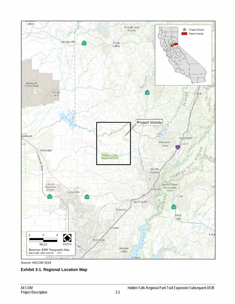
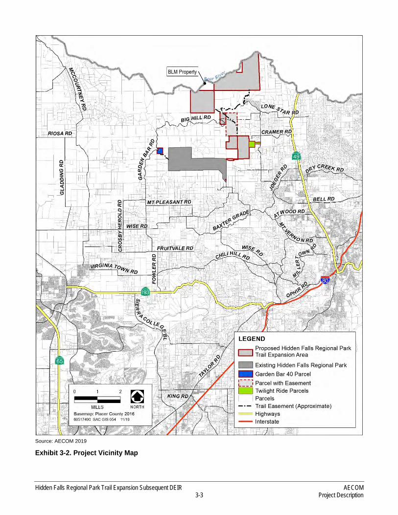
The proposed trail expansion areas are located northeast of the existing HFRP, and south of the Bear River in Placer County, approximately 40 miles northeast of Sacramento (see Exhibit 3-1), as well as to the west and east of the park. HFRP currently encompasses approximately 1,200 acres in the Sierra Nevada foothills, consisting of portions of family ranches previously owned by Spears (979 acres) and Didion (221 acres).
The existing park has two access points that were analyzed and permitted with the original EIR in 2010. The first access point is located off Mears Place and is currently the only allowable public parking area and entrance to HFRP. The second permitted access point is off Garden Bar Road but is not currently developed for public parking or access. However, access for County staff, contracted ranger staff and emergency personnel is available via both the Mears Place and Garden Bar entrances. Exhibit 3-2 shows the project area including regional highways (e.g., State Route 49) and local roads, including Big Hill Road through the center of the project area; Mt. Pleasant Road and Mt. Vernon Road to the south; Bell Road, Cramer Road, and Lone Star Road to the east; and Garden Bar Road to the west.
AECOM Hidden Falls Regional Park Trail Expansion Subsequent DEIR Project Description 3-2
Source: AECOM 2019
Exhibit 3-1. Regional Location Map
Hidden Falls Regional Park Trail Expansion Subsequent DEIR AECOM 3-3 Project Description
Source: AECOM 2019
Exhibit 3-2. Project Vicinity Map
AECOM Hidden Falls Regional Park Trail Expansion Subsequent DEIR Project Description 3-4
3.2 EXISTING SETTING
3.2.1 EXISTING REGIONAL PARK
The existing HFRP covers 1,200 acres and has approximately 30 miles of natural-surface, multi-use trails, with public parking located at Mears Place. The trails within the park cross Raccoon Creek and Deadman Creek via bridges in three locations. Raccoon Creek flows through the park from east to west and Deadman Creek joins Raccoon Creek from the south. Natural surface emergency access roads (which also double as internal backbone trails) are located on both sides of Raccoon Creek and enable rangers and emergency response vehicles to access the entirety of the park. Existing HFRP amenities include two waterfall overlooks, interpretive displays, restrooms, drinking fountains, picnic areas, benches, trash receptacles, and hitching posts and horse-watering areas for equestrians.
Since fully opening to the public in 2013, HFRP has grown substantially in popularity and visitation. As a result, beginning in 2014, the parking area at Mears Place had become congested on holidays and weekends during good weather, and visitors were frequently turned away during these peak-use periods.
The County Parks Division subsequently implemented new measures to rectify the existing parking issues, and to lessen impacts on nearby landowners. These measures include:
► Installing “No Parking” signs on Mears Place, Mears Drive, and an approximately 2-mile segment of Mount Vernon Road.
► Encouraging visitors to use HFRP during off-peak days and times, carpool, and arrive early.
► Establishing social media sites (i.e., Facebook and Twitter) to provide up-to-date information on parking lot status. These websites, along with the web-cam discussed in the next bullet, enable potential park visitors to check parking availability before driving to the park.
► Installing a web-cam with a view of the Mears Place parking area to provide real-time information on parking availability at: https://www.placer.ca.gov/2623/Webcam.
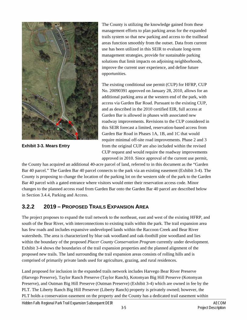
► Reconfiguring the Mears Place entrance to enhance traffic flow. This included minor paving, signage, and pavement striping to change the direction of traffic and create a one-way flow (See Exhibit 3-3).
► Establishing an automated reservation system to help regulate parking on weekends, holidays and other high use days. Implementation began September 1, 2017. Reservations are obtained online by patrons prior to arrival at the park, thereby minimizing unnecessary vehicle trips to/from the park and reducing vehicle trips on the local roads. Visitors make reservations via an online calendar linked to the HFRP web site1.
► Constructing an entrance gate/ticket kiosk area (with attendant or automated) to support the reservation-based system of entry.
1 https://secure.rec1.com/CA/placer-ca/catalog
Hidden Falls Regional Park Trail Expansion Subsequent DEIR AECOM 3-5 Project Description
The County is utilizing the knowledge gained from these management efforts to plan parking areas for the expanded trails system so that new parking and access to the trailhead areas function smoothly from the outset. Data from current use has been utilized in this SEIR to evaluate long-term management strategies, provide for sustainable parking solutions that limit impacts on adjoining neighborhoods, improve the current user experience, and define future opportunities.
The existing conditional use permit (CUP) for HFRP, CUP No. 20090391 approved on January 28, 2010, allows for an additional parking area at the western end of the park, with access via Garden Bar Road. Pursuant to the existing CUP, and as described in the 2010 certified EIR, full access at Garden Bar is allowed in phases with associated new roadway improvements. Revisions to the CUP considered in this SEIR forecast a limited, reservation-based access from Garden Bar Road in Phases 1A, 1B, and 1C that would require minimal off-site road improvements. Phase 2 and 3 from the original CUP are also included within the revised CUP request and would require the roadway improvements approved in 2010. Since approval of the current use permit,
the County has acquired an additional 40-acre parcel of land, referred to in this document as the “Garden Bar 40 parcel.” The Garden Bar 40 parcel connects to the park via an existing easement (Exhibit 3-4). The County is proposing to change the location of the parking lot on the western side of the park to the Garden Bar 40 parcel with a gated entrance where visitors would enter their reservation access code. Minor changes to the planned access road from Garden Bar onto the Garden Bar 40 parcel are described below in Section 3.4.4, Parking and Access.
3.2.2 2019 – PROPOSED TRAILS EXPANSION AREA
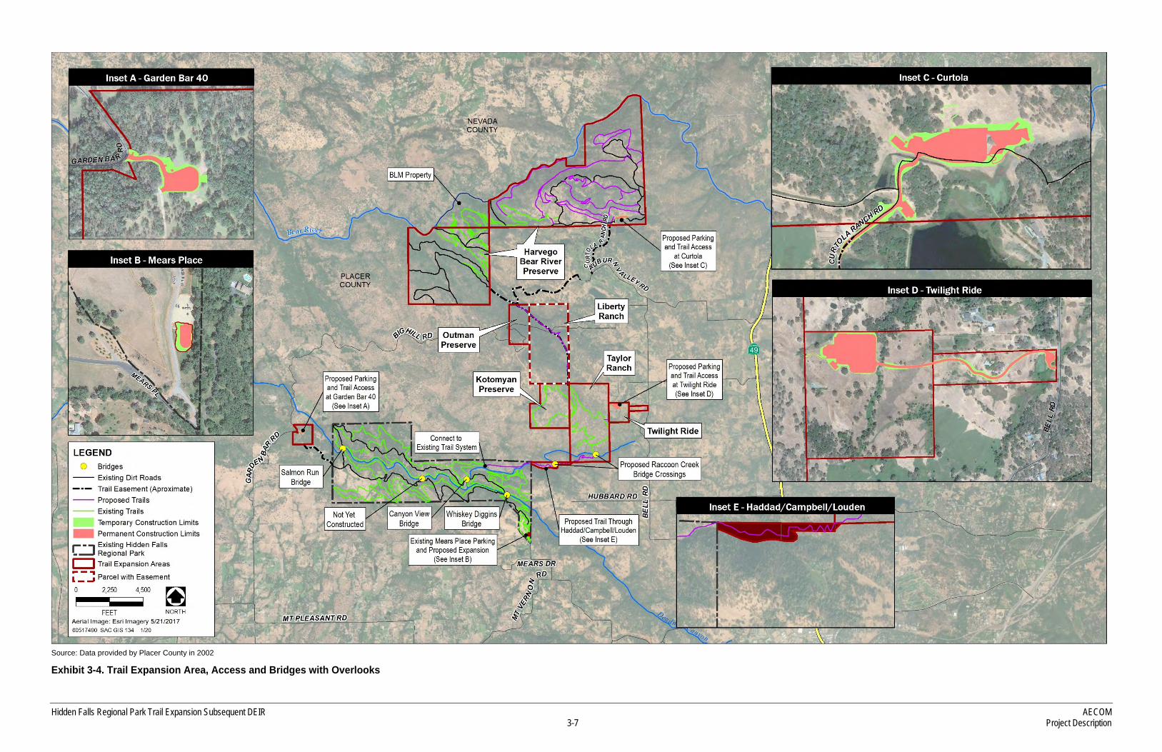
The project proposes to expand the trail network to the northeast, east and west of the existing HFRP, and south of the Bear River, with interconnections to existing trails within the park. The trail expansion area has few roads and includes expansive undeveloped lands within the Raccoon Creek and Bear River watersheds. The area is characterized by blue oak woodland and oak-foothill pine woodland and lies within the boundary of the proposed Placer County Conservation Program currently under development. Exhibit 3-4 shows the boundaries of the trail expansion properties and the planned alignment of the proposed new trails. The land surrounding the trail expansion areas consists of rolling hills and is comprised of primarily private lands used for agriculture, grazing, and rural residences.
Land proposed for inclusion in the expanded trails network includes Harvego Bear River Preserve (Harvego Preserve), Taylor Ranch Preserve (Taylor Ranch), Kotomyan Big Hill Preserve (Kotomyan Preserve), and Outman Big Hill Preserve (Outman Preserve) (Exhibit 3-4) which are owned in fee by the PLT. The Liberty Ranch Big Hill Preserver (Liberty Ranch) property is privately owned; however, the PLT holds a conservation easement on the property and the County has a dedicated trail easement within
Exhibit 3-3. Mears Entry
AECOM Hidden Falls Regional Park Trail Expansion Subsequent DEIR Project Description 3-6
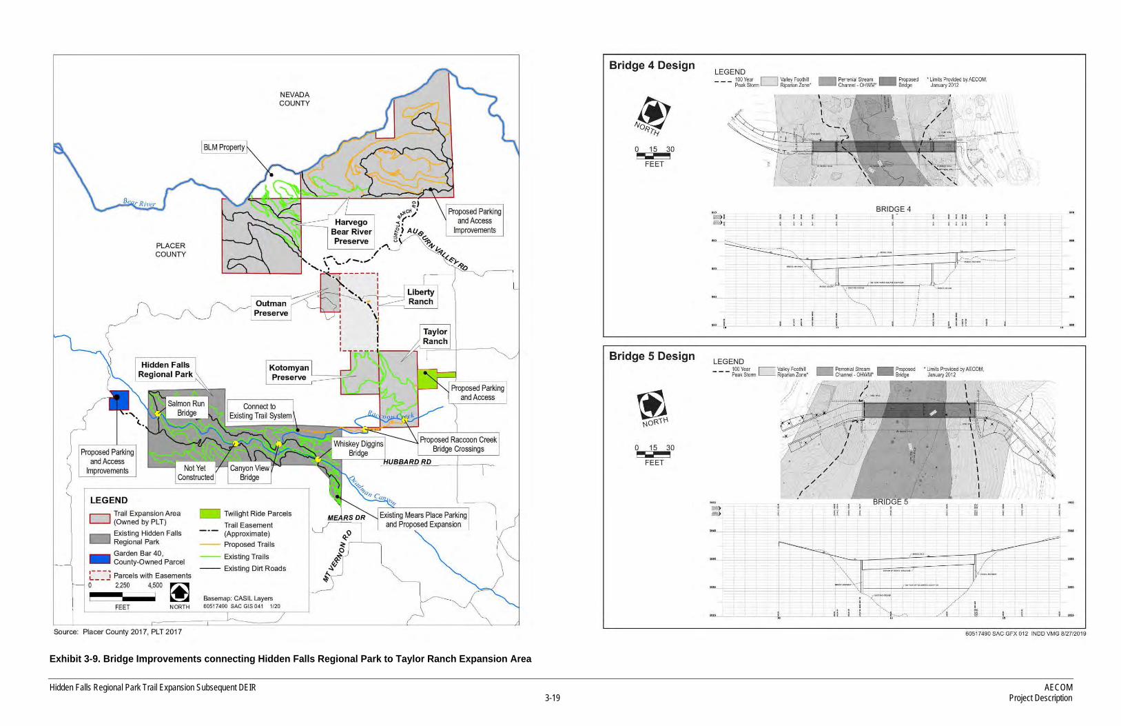
the property that connects to the other PLT-owned parcels. The County’s trail easement on the Liberty Ranch property is limited to a previously-surveyed 15-foot-wide corridor, and the trail easement on Taylor Ranch was required to be surveyed along its planned alignment and was recorded as a linear easement. The trail easements on the Harvego Preserve areas are “blanket” in nature and not limited to prior established corridors. Taylor Ranch (321 acres) has an existing 3 1/2-mile loop trail that also connects to a 2 1/2 –mile existing trail loop on the 160-acre Kotomyan Preserve to the west. Liberty Ranch (313 acres) is a cattle ranch currently under Williamson Act contract with no existing trails. The Outman Preserve (80 acres) also has no existing trails. Harvego Preserve (1,773 acres) has a working cattle ranch and an extensive network of existing dirt ranch roads and some trails built by the PLT. This parcel connects to the other trail expansion areas via an existing easement. The Twilight Ride property is located adjacent to Taylor Ranch and is accessed directly off of Bell Road. The County-owned connectivity parcels and easement areas directly east of the HFRP abut Raccoon Creek, and connect the existing HFRP with the Taylor Ranch parcel.
TAYLOR RANCH
The Taylor Ranch was purchased in 2007 by the Placer Land Trust. County funds were utilized to help with the purchase price, with the agreement to allow for a public, multi-use trail system on the property. Taylor Ranch is approximately 321 acres, and is located at the end of Orr Creek Lane, just north of the City of Auburn, in the unincorporated area of Placer County. It corresponds to Placer County Assessor’s Parcel Numbers 026-110-001 and 026-120-028. Taylor Ranch exists between the Kotomyan Preserve to the west and Twilight Ride parcels to the east and touches the southeast corner of the Liberty Ranch parcel to the north. It ties the “Connectivity Parcels” described above to the Kotomyan Preserve and Liberty Ranch. Activities on Taylor Ranch are currently managed by the PLT under the Management Plan for Taylor Ranch. There are approximately 3 1/2 miles of existing natural-surface trails on this property which are utilized for docent-led tours by PLT. The location of Taylor Ranch is shown in Exhibit 3-4.
KOTOMYAN PRESERVE
The Kotomyan Preserve is approximately 160 acres, and is located on New Hope School Road, just north of the City of Auburn, in the unincorporated area of Placer County. Kotomyan Preserve corresponds to Placer County Assessor’s Parcel Numbers 026-081-040 and 026-081-044. It is adjacent to both Liberty Ranch and Taylor Ranch (both of which have been permanently protected by PLT), lies south and west of the corner of these two preserves, and connects the two preserves. Kotomyan Preserve is one parcel removed (about 2,500 feet) from the existing HFRP. Activities on the preserve are currently regulated by the Kotomyan Big Hill Preserve Management Plan and managed by the PLT. There are approximately 2 1/2 miles of existing natural-surface trails on this property which are utilized for docent-led tours by PLT.
LIBERTY RANCH
In 2007, a Conservation Easement was purchased for the Liberty Ranch. As a part of this agreement, a 15-foot wide multi-use trail easement for the public was established which connects Taylor Ranch and Kotomyan Preserve with the easement leading to the Harvego Preserve. Liberty Ranch is 313 acres in size and located northwest of the City of Auburn and northeast of the City of Lincoln, in the unincorporated area of Placer County. It corresponds to Placer County Assessor’s Parcel Number 026-061-013-510. The
Hidden Falls Regional Park Trail Expansion Subsequent DEIR AECOM 3-7 Project Description
Source: Data provided by Placer County in 2002
Exhibit 3-4. Trail Expansion Area, Access and Bridges with Overlooks

AECOM Hidden Falls Regional Park Trail Expansion Subsequent DEIR Project Description 3-8
This page intentionally left blank
Hidden Falls Regional Park Trail Expansion Subsequent DEIR AECOM 3-9 Project Description
topography of Liberty Ranch varies throughout and the site is characterized by perennial and ephemeral streams draining steep rocky outcroppings, oak woodland savannahs, and riparian corridors. Livestock seasonally graze Liberty Ranch.
HARVEGO PRESERVE
With the County’s monetary assistance, the Harvego Preserve was purchased in 2010 for its conservation values and was intended to allow for public use of any existing trails and ranch roads or constructed multi-use trails. As a part of the purchase, the County acquired a Conservation Easement over the property which conveyed to the County the right to construct and operate a non-motorized multi-use trail system and associated facilities, including staging areas, access roads, parking restroom facilities, picnic areas and water and sewer disposal facilities. The 1,773 acre property is located south of the Bear River, west of Sisson Lane, and north of Big Hill Road and corresponds to Placer County Assessor’s Parcel Numbers 026-020-009, 026-020-011, 026-020-012, 026-020-013, 026-061-001, 026-061-003, 026-061-007, 026-061-051, 026-061-068. The Bear River forms the northern boundary line, dividing Placer County from Nevada County and drains the northern part of Placer County. The U.S. Bureau of Land Management (BLM) owns the area between the two portions of the Harvego Preserve and south of the Bear River (Exhibit 3-4). A trail easement across land retained by the Harvego family provides trail access between the two portions of the Harvego Preserve. The main vegetation types on Harvego Preserve are blue oak woodlands, blue oak – foothill pine, montane hardwoods, riparian and riverine habitat, and annual grassland habitat. Bald Rock mountain is the highest point in elevation at 1,694 feet above mean sea level (msl). The Harvego Bear River Management Plan regulates activities on the preserve. The plan governs multiple uses on the property including wildlife habitat, scenic open space, and use for agriculture and recreation.
OUTMAN PRESERVE
Purchased by the Placer Land Trust in 2012 with the help of County funds, the Outman Preserve is 80 acres in size, and is located northwest of the City of Auburn, on Big Hill Road, in unincorporated Placer County. The County holds an easement to allow for a public, multi-purpose trail on the property. The Outman Preserve corresponds to Placer County Assessor’s Parcel Number 026-061-055. The property is characterized by gently sloping blue oak woodlands, steep montane hardwood and foothill pine woodlands, an ephemeral stream, a perennial stream and a riparian corridor with native willow and alder. Over the past several generations, the Outman Preserve has been grazed by cattle, and is currently supporting seasonal cattle grazing.
CONNECTIVITY PARCELS
In 2013, land and/or easements which connected the existing HFRP with Taylor Ranch were purchased. These connectivity parcels consist of 11.04 acres purchased from the Haddad family (a portion of Assessor’s Parcel Number 026-080-073), 6.5 acres purchased from the Campbell family (portions of Assessor’s Parcel Numbers 026-080-059 and 026-080-060) as well as a conservation easement for an additional 5.4 acres south of Raccoon Creek (Assessor’s Parcel Number 026-080-059), and a multipurpose trail easement over approximately 0.2 acres of the Loudon parcel (Assessor’s Parcel Number 026-130-041). These parcels and easements were purchased with the intent to provide trail

AECOM Hidden Falls Regional Park Trail Expansion Subsequent DEIR Project Description 3-10
connectivity between the existing park area and the trail expansion areas. The location of the connectivity parcels and easements is shown in Exhibit 3-4.
GARDEN BAR 40 PARCEL
The Garden Bar 40 parcel was purchased in 2016 by Placer County and would provide access and a parking area directly off of Garden Bar Road. An existing easement connects this parcel with the west side of HFRP.
TWILIGHT RIDE PROPERTY
The Twilight Ride property is comprised of two parcels consisting of a 10-acre parcel (APN 026-110-012) and a 40-acre parcel (APN 026-110-018) and is located in the unincorporated area of Placer County, south of the Bear River. The County entered into a Purchase and Sale Agreement with the owners of the Twilight Ride property in 2018. These negotiations may result in the eventual purchase of the property. Topography of the site is gentle with an elevation differential ranging from approximately 1,075 to 1,240 feet above mean sea level from southwest to northeast. The property lies within the Raccoon Creek watershed and is approximately 0.25 mile north of Raccoon Creek. The property is dominated by annual grasslands with scattered blue oak (Quercus douglasii) and patches of blue oak woodland. The 10-acre portion includes an existing single-family residence and various out-buildings. The 40-acre parcel has an existing storage structure near the middle of the parcel. A parking area on the northwest portion of the 40-acre parcel is proposed with this project. The parking area would connect with the existing trails located on Taylor Ranch. An access road would connect Bell Road with the parking area on the 40-acre parcel.
3.3 PROJECT OBJECTIVES
The objectives of the Proposed Project are similar to those developed for originally establishing HFRP. However they expand upon the prior objectives to accommodate additional facilities. The following objectives were developed by the County specifically for the proposed trail network and parking expansion:
► Support County goals for trails as outlined in the 2013 General Plan Update Recreational Trails Element Goal 5.C for developing a system of interconnected hiking, riding, and bicycling trails and paths suitable for active recreation and transportation and circulation.
► Implement the recreational resource objectives of the Placer Legacy Open Space and Agricultural Conservation Program (available at https://www.placer.ca.gov/3420/Placer-Legacy), beginning on page 3-17 that aim to enhance recreational opportunities in the County by improving public trail access, including the construction of staging areas and parking lots, as well as the purchase of public access easements on private land to provide connections to public land and city trail connections and provide regional recreational facilities in the foothill region, supplementing the recreation opportunities provided on public lands to the east and municipal park facilities in urbanized areas. South Placer residents would be served by one or more large regional parks (300 acres or greater) in a rural setting with a variety of passive recreation opportunities. Such a park may be connected with larger area of protected land, providing additional wildlife habitat value.
Hidden Falls Regional Park Trail Expansion Subsequent DEIR AECOM 3-11 Project Description
► Provide expanded opportunities for public passive recreation and educational access without overburdening natural resources, local roadways or adjacent communities.
► Expand the existing multi-use, natural-surface trail system to provide recreational opportunities for the residents of Placer County and the region, while maintaining safety for park users, visitors, and nearby residents.
► Create new areas for public parking that function smoothly from the outset.
► Create connectivity between the existing trails in HFRP and the expanded trail network.
► Expand on opportunities for natural, cultural, agricultural and historic resource education, fostering stewardship and environmental awareness.
3.4 2019 – PROPOSED PROJECT COMPONENTS
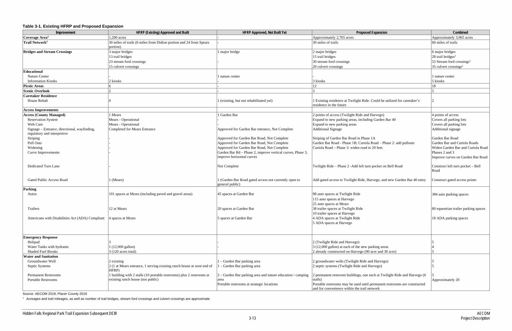
Since 2007, the County has partnered with the PLT to preserve approximately 2,765 acres of open space located north and east of HFRP (see Table 3-1) with the expressed purpose of allowing public recreation on the properties. These lands, as well as connecting areas directly east and west of the existing HFRP that are either owned or held in easement by the County, would accommodate the proposed expansion of HFRP’s public trail network and associated facilities. The expanded trail network would link the existing HFRP to the Bear River, creating a network of more than 60 miles of multi-use trails. The expanded trails network would connect Taylor Ranch to existing trails in HFRP via the connectivity properties purchased by the County east of HFRP (Haddad and Campbell properties) and easements acquired (Loudon property). Additional easements through Liberty Ranch and the Outman Preserve connect the Taylor Ranch and Kotomyan Preserve to future and existing trails and ranch roads within the Harvego Preserve. A new parking area proposed for the Twilight Ride property would allow public access directly off of Bell Road and would provide an intermediate parking area located between the existing parking area on Mears Place, and the most northerly parking area proposed for the Harvego Preserve. A summary of the primary amenities available at the existing HFRP, those proposed as part of the current project, and the resultant total of the expanded park/trail network at buildout of the proposed project is provided in Table 3-1.
The County’s discretionary actions associated with the expanded trails network would include approval of an amended CUP covering the existing HFRP and the trail and access expansion areas, including the designated lands to the northeast, the Garden Bar 40 parcel west of the existing HFRP that was acquired by the County in 2016, and the areas east of the park that connect to Taylor Ranch. The amended CUP would cover:
► Expanding the HFRP trails network from 30 miles to approximately 60 miles through the addition of existing trails and construction of new trails within the lands owned or held in conservation easements by the PLT, or on lands owned by Placer County, or where the County holds trail easements;
► Constructing two additional bridges over Raccoon Creek and one major culvert crossing over a tributary to Raccoon Creek between the existing HFRP trail network and Taylor Ranch;

AECOM Hidden Falls Regional Park Trail Expansion Subsequent DEIR Project Description 3-12
► Adding parking and access areas improvements, including parking and access at Harvego Preserve off Curtola Ranch Road for access to the northern areas of the expanded trail network, on the Twilight Ride property off of Bell Road to provide access midway through the expansion area, as well as the parking area on the Garden Bar 40 parcel for access to the western end of the expansion area;
► Changes from the previously approved access and parking area from Garden Bar Road on the west side of HFRP to access and parking planned on the newly acquired Garden Bar 40 parcel;
► The addition of up to 25 more overflow automobile parking spots at the Mears Place entrance;
► Identifying and clarifying the type and size of events allowed at the Garden Bar entrance and facilities allowed within the existing HFRP and expansion area;
► Construction of supporting facilities including restroom facilities, water wells, stream crossings, viewing platforms, picnic areas, benches, signage, drinking fountains, animal proof trash/recycle receptacles, fire suppression facilities, emergency/maintenance access roads, equestrian facilities, fencing;
► Allowed uses including recreational uses, grazing, agriculture, nature/cultural education, organized events (i.e. cross country track meets, docent led tours), film & theater production, hunting and fishing (fishing according to CA Dept. of Fish and Wildlife Freshwater Fishing Regulations, depredation hunting by County/federal wildlife specialists); and
► Management means and methods including hours of operation, use of reservation system, operation of public water supply permit(s) and Transient Non-community Water System permit(s), regulatory compliance.
The County anticipates that the trail expansion will result in a modified CUP that will supersede the existing CUP No. 20090391 and will encompass the allowed uses and operating principles within the existing park as well as the expansion areas. As part of the proposed modification, the types of allowed uses and facilities within the existing park and the trail expansion areas will be clarified. The types of facilities proposed within the trail expansion areas include a natural-surface, multi-use trail system, bridges, overlooks, benches, kiosks, picnic areas, trash receptacles, drinking fountains, accessible amenities, equestrian amenities (horse watering facilities, hitching posts), as well as access and parking areas (with associated restrooms, wells, septic areas and emergency response landing zones). Allowed uses within the expansion areas would include use of a multi-purpose trail system by hikers, bicyclists and equestrians, as well as the provision for outdoor education classes, grazing and other agricultural uses, fishing, depredation hunting, and film and theater production (subject to County Film Permit requirements).
County staff also intends to request that disc golf, which was allowed with the original use permit, be removed from the list of allowed uses under the modified use permit within the HFRP and HFRP Trail Expansion areas.
Hidden Falls Regional Park Trail Expansion Subsequent DEIR AECOM 3-13 Project Description
Table 3-1. Existing HFRP and Proposed Expansion Improvement HFRP (Existing) Approved and Built HFRP Approved, Not Built Yet Proposed Expansion Combined
Coverage Area1 1,200 acres - Approximately 2,765 acres Approximately 3,965 acres Trail Network1 30 miles of trails (6 miles from Didion portion and 24 from Spears
portion) - 30 miles of trails 60 miles of trails
Bridges and Stream Crossings 3 major bridges 1 major bridge 2 major bridges 6 major bridges 13 trail bridges 15 trail bridges 28 trail bridges1 23 stream ford crossings - 30 stream ford crossings 53 Stream ford crossings1 15 culvert crossings 20 culvert crossings 35 culvert crossings1
Educational Nature Center - 1 nature center - 1 nature center Information Kiosks 2 kiosks - 3 kiosks 5 kiosks
Picnic Areas 6 - 12 18 Scenic Overlook 2 - 3 5 Caretaker Residence
House Rehab 0 1 (existing, but not rehabilitated yet) 1 Existing residence at Twilight Ride. Could be utilized for caretaker’s residence in the future
2
Access Improvements Access (County Managed) 1 Mears 1 Garden Bar 2 points of access (Twilight Ride and Harvego) 4 points of access
Reservation System Mears - Operational - Expand to new parking areas, including Garden Bar 40 Covers all parking lots Web Cam Mears - Operational - Expand to new parking areas Covers all parking lots Signage – Entrance, directional, wayfinding, regulatory and interpretive
Completed for Mears Entrance Approved for Garden Bar entrance, Not Complete Additional Signage Additional signage
Striping - Approved for Garden Bar Road, Not Complete Striping of Garden Bar Road in Phase 1A Garden Bar Road Pull Outs - Approved for Garden Bar Road, Not Complete Garden Bar Road - Phase 1B; Curtola Road – Phase 2: add pullouts Garden Bar and Curtola Roads Widening - Approved for Garden Bar Road, Not Complete Curtola Road – Phase 3: widen road to 20 feet. Widen Garden Bar and Curtola Road Curve Improvements - Garden Bar Rd – Phase 2, improve vertical curves, Phase 3,
improve horizontal curves Phases 2 and 3
Improve curves on Garden Bar Road
Dedicated Turn Lane - Not Complete Twilight Ride – Phase 2 -Add left turn pocket on Bell Road Construct left turn pocket – Bell Road
Gated Public Access Road 1 (Mears) 1 (Garden Bar Road gated access not currently open to general public)
Add gated access to Twilight Ride, Harvego, and new Garden Bar 40 entry Construct gated access points
Parking Autos 101 spaces at Mears (including paved and gravel areas) 45 spaces at Garden Bar 98 auto spaces at Twilight Ride 384 auto parking spaces 115 auto spaces at Harvego 25 auto spaces at Mears Trailers 12 at Mears 20 spaces at Garden Bar 38 trailer spaces at Twilight Ride 80 equestrian trailer parking spaces 10 trailer spaces at Harvego Americans with Disabilities Act (ADA) Compliant 4 spaces at Mears 5 spaces at Garden Bar 4 ADA spaces at Twilight Ride
5 ADA spaces at Harvego 18 ADA parking spaces
Emergency Response Helipad 3 - 2 (Twilight Ride and Harvego) 5 Water Tanks with hydrants 1 (12,000 gallon) - 3 (12,000 gallon) at each of the new parking areas 4 Shaded Fuel Breaks 3 (120 acres total) 2 already constructed on Harvego (90 acre and 30 acre) 5
Water and Sanitation Groundwater Well 2 existing 1 – Garden Bar parking area 2 groundwater wells (Twilight Ride and Harvego) 5 Septic Systems 2 (1 at Mears entrance, 1 serving existing ranch house at west end of
HFRP) 1 – Garden Bar parking area 2 septic systems (Twilight Ride and Harvego) 5
Permanent Restrooms Portable Restrooms
1 building with 2 stalls (10 portable restrooms) plus 2 restrooms at existing ranch house (not public)
2 – Garden Bar parking area and nature education / camping area Portable restrooms at strategic locations
2 permanent restroom buildings, one each at Twilight Ride and Harvego (6 stalls) Portable restrooms may be used until permanent restrooms are constructed and for convenience within the trail network
5 Approximately 20
Source: AECOM 2019; Placer County 2019 1 Acreages and trail mileages, as well as number of trail bridges, stream ford crossings and culvert crossings are approximate

AECOM Hidden Falls Regional Park Trail Expansion Subsequent DEIR Project Description 3-14
This page intentionally left blank
Hidden Falls Regional Park Trail Expansion Subsequent DEIR AECOM 3-15 Project Description
Additionally, the preliminary plan for horse boarding and concessions listed as project components for the Twilight Ride property in the 2018 Notice of Preparation (NOP) have been removed from the Project Description of this SEIR due to input from surrounding neighbors as well as the financial infeasibility of horse boarding at the scale proposed.
Lastly, the allowance for a limited number of privately-owned parking areas adjacent to the park boundaries (with a total capacity between the privately-owned parking areas of 60 parking spots) has been removed from the Project Description since the Revised NOP was published.
3.4.1 MULTI-USE TRAILS
The expanded trails network shown in Exhibit 3-4 would connect existing HFRP trails with areas and trails owned or held in conservation easement by the PLT, and areas owned by the County or where the County has easements. Trail use would be limited to hiking, bicycling, and horseback riding. No motorized vehicles, other than maintenance and emergency response vehicles, and vehicles that provide accessibility assistance consistent with the Americans with Disabilities Act (ADA) and related law, would be allowed within the trails expansion area. County staff is monitoring the rising popularity of electric bikes (e-bikes), and will make recommendations to the Board of Supervisors on their regulated use within public recreation areas through the Public Recreation Ordinance (Placer County Code Section 12.24) as standards and policies are developed throughout the industry. The expanded trails network would include existing trails, existing dirt roads and paths, and new trails based on the proposed trail layout developed jointly by the County and the PLT. The preliminary layout accounts for approximately 30 miles of additional multi-use trails. The layout was developed based on each area’s opportunities and constraints, including topography, drainage crossings, locations of cattle
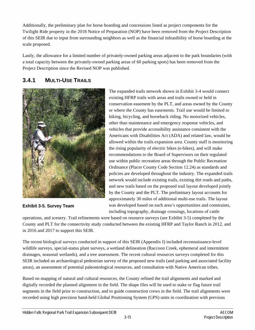
operations, and scenery. Trail refinements were based on resource surveys (see Exhibit 3-5) completed by the County and PLT for the connectivity study conducted between the existing HFRP and Taylor Ranch in 2012, and in 2016 and 2017 to support this SEIR.
The recent biological surveys conducted in support of this SEIR (Appendix I) included reconnaissance-level wildlife surveys, special-status plant surveys, a wetland delineation (Raccoon Creek, ephemeral and intermittent drainages, seasonal wetlands), and a tree assessment. The recent cultural resources surveys completed for this SEIR included an archaeological pedestrian survey of the proposed new trails (and parking and associated facility areas), an assessment of potential paleontological resources, and consultation with Native American tribes.
Based on mapping of natural and cultural resources, the County refined the trail alignments and marked and digitally recorded the planned alignment in the field. The shape files will be used to stake or flag future trail segments in the field prior to construction, and to guide construction crews in the field. The trail alignments were recorded using high precision hand-held Global Positioning System (GPS) units in coordination with previous
Exhibit 3-5. Survey Team

AECOM Hidden Falls Regional Park Trail Expansion Subsequent DEIR Project Description 3-16
trail location data collected for existing and planned trails by the County and the PLT. Data recorded were then used to create a master alignment to guide further refinement of the design. Trail attributes collected in the field included existing trail status (dirt ranch road or dirt trail), canopy coverage, and slope.
The proposed trail alignments are located within existing trail easements established over portions of the expansion area. However, the final trail alignments could require adjustment of the easements in some places. Trail alignments within the easement over the Liberty Ranch property are limited to a 15-foot-wide corridor, and trail alignments on Taylor Ranch and the Kotomyan Preserve were designed and previously constructed as described above. The County has “blanket” trail easement rights over the Harvego Preserve, owned in fee by the PLT, which presents more flexibility to adjust future trail refinements. Should further refinements be needed based on constructability assessments or during construction based on field conditions, presence of biological or cultural resources, or permit requirements, the constructed alignment would be recorded, marked on as-built drawings, and any necessary adjusted trail easement documentation would be kept on file by the County and the PLT. The trail design would be similar to the existing trails within HFRP, as shown in Exhibit 3-6.
The proposed project also includes, and this SEIR evaluates, potential future development of additional trails within the PLT-owned parcels but not depicted in Exhibit 3-4 is a possibility, but not addressed in this SEIR. These trails could be added in the future in areas where the County’s trail easements are “blanket” in nature. These could include additional trail segments to provide connectivity or to provide additional recreational opportunities. Any new trails would be constructed within trail easements that would be obtained from the PLT or other willing landowners. Additional trails and associated amenities may be
developed specifically for the benefit of visitors with physical handicaps, above and beyond minimum compliance with the ADA. Future trails could also be constructed to provide connectivity with the Bear River and recently constructed BLM trails located north of Harvego Preserve (Exhibit 3-4). Additional trails and amenities planned, designed and completed in the future would be addressed in future tiered CEQA documents as appropriate and would require additional resource surveys prior to completion.
3.4.2 AMENITIES
The proposed new trails would be outfitted with amenities similar to those currently available in HFRP. These would include accessibility features compliant with the ADA, drinking water fountains, restrooms, on-site groundwater wells, fire suppression facilities, equestrian features (e.g., horse watering, hitching posts), picnic areas, observation decks at scenic vista points, benches, bear-proof trash receptacles, landscaping and irrigation,
Exhibit 3-6. Hidden Falls Regional Park – Existing Trail Segment

Hidden Falls Regional Park Trail Expansion Subsequent DEIR AECOM 3-17 Project Description
and interpretive displays. Exhibit 3-7 shows an existing picnic area within HFRP near Raccoon Creek. Future picnic areas in the Proposed Project would be similar in type.
Recreational opportunities could also include access to fishing locations along Raccoon Creek and the Bear River. To provide trail connectivity, the County would construct two bridges over Raccoon Creek. Many rock/culvert passages and timber bridges over intermittent streams would also make interconnections within the existing and proposed trail system. One tributary of Raccoon Creek that lies between HFRP and Taylor Ranch would require spanning with multiple culverts, box culverts, or a bridge.
3.4.3 BRIDGES AND CREEK CROSSINGS
Similar to bridges previously proposed and approved for the HFRP and considered in the prior EIR, new bridges would be designed to minimize impacts on stream hydrology and wildlife. Future bridges would be similar to existing bridges in design (see Exhibit 3-8).
Bridge 4 is proposed in a narrow canyon and would be accessible by pedestrians, equestrians, bicyclists and vehicles used by County Parks and contracted ranger staff, Placer Land Trust staff and Emergency Medical Response personnel. The bridge
design anticipates a total span of approximately 128 feet long and 10 feet wide that will be supported by two intermediate center columns. The abutments would likely be concrete; however, the selected materials would be determined during final design. Decking and other structural components may be made of weathering steel, fiberglass, concrete, steel cable, or other suitable materials. Local rock or imitation rock may also be used as facing on concrete abutments.
Bridge 5 is planned as a pre-manufactured steel truss bridge approximately 100 feet long and 12 feet wide. It will be accessible to Emergency Medical Response and County Parks and contracted ranger staff vehicles, as well as pedestrians, bicyclists and equestrians.
Exhibit 3-7. Hidden Falls Regional Park – Existing Picnic Area near Raccoon Creek
Exhibit 3-8. Hidden Falls Regional Park – Existing Major Bridge over Raccoon Creek
AECOM Hidden Falls Regional Park Trail Expansion Subsequent DEIR Project Description 3-18
Exhibit 3-9 provides additional detail regarding the proposed bridge locations within trail easements acquired by the County to connect the existing HFRP and Taylor Ranch.
The County would also construct pedestrian/equestrian footbridges or culverts over intermittent drainages throughout the expanded trails network where crossings are necessary. Like existing footbridges, they would be designed to fit the rustic character of the surroundings and may require construction or replacement of culverts or construction of rock-lined stream crossings. Rock fords would be placed in ephemeral drainages to provide a level surface and prevent erosion.
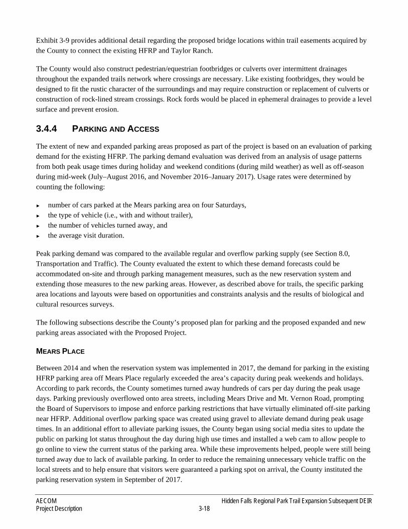
3.4.4 PARKING AND ACCESS
The extent of new and expanded parking areas proposed as part of the project is based on an evaluation of parking demand for the existing HFRP. The parking demand evaluation was derived from an analysis of usage patterns from both peak usage times during holiday and weekend conditions (during mild weather) as well as off-season during mid-week (July–August 2016, and November 2016–January 2017). Usage rates were determined by counting the following:
► number of cars parked at the Mears parking area on four Saturdays, ► the type of vehicle (i.e., with and without trailer), ► the number of vehicles turned away, and ► the average visit duration.
Peak parking demand was compared to the available regular and overflow parking supply (see Section 8.0, Transportation and Traffic). The County evaluated the extent to which these demand forecasts could be accommodated on-site and through parking management measures, such as the new reservation system and extending those measures to the new parking areas. However, as described above for trails, the specific parking area locations and layouts were based on opportunities and constraints analysis and the results of biological and cultural resources surveys.
The following subsections describe the County’s proposed plan for parking and the proposed expanded and new parking areas associated with the Proposed Project.
MEARS PLACE
Between 2014 and when the reservation system was implemented in 2017, the demand for parking in the existing HFRP parking area off Mears Place regularly exceeded the area’s capacity during peak weekends and holidays. According to park records, the County sometimes turned away hundreds of cars per day during the peak usage days. Parking previously overflowed onto area streets, including Mears Drive and Mt. Vernon Road, prompting the Board of Supervisors to impose and enforce parking restrictions that have virtually eliminated off-site parking near HFRP. Additional overflow parking space was created using gravel to alleviate demand during peak usage times. In an additional effort to alleviate parking issues, the County began using social media sites to update the public on parking lot status throughout the day during high use times and installed a web cam to allow people to go online to view the current status of the parking area. While these improvements helped, people were still being turned away due to lack of available parking. In order to reduce the remaining unnecessary vehicle traffic on the local streets and to help ensure that visitors were guaranteed a parking spot on arrival, the County instituted the parking reservation system in September of 2017.
Hidden Falls Regional Park Trail Expansion Subsequent DEIR AECOM 3-19 Project Description
Exhibit 3-9. Bridge Improvements connecting Hidden Falls Regional Park to Taylor Ranch Expansion Area

AECOM Hidden Falls Regional Park Trail Expansion Subsequent DEIR Project Description 3-20
This page intentionally left blank
Hidden Falls Regional Park Trail Expansion Subsequent DEIR AECOM 3-21 Project Description
Source: Foothill Associates 2019
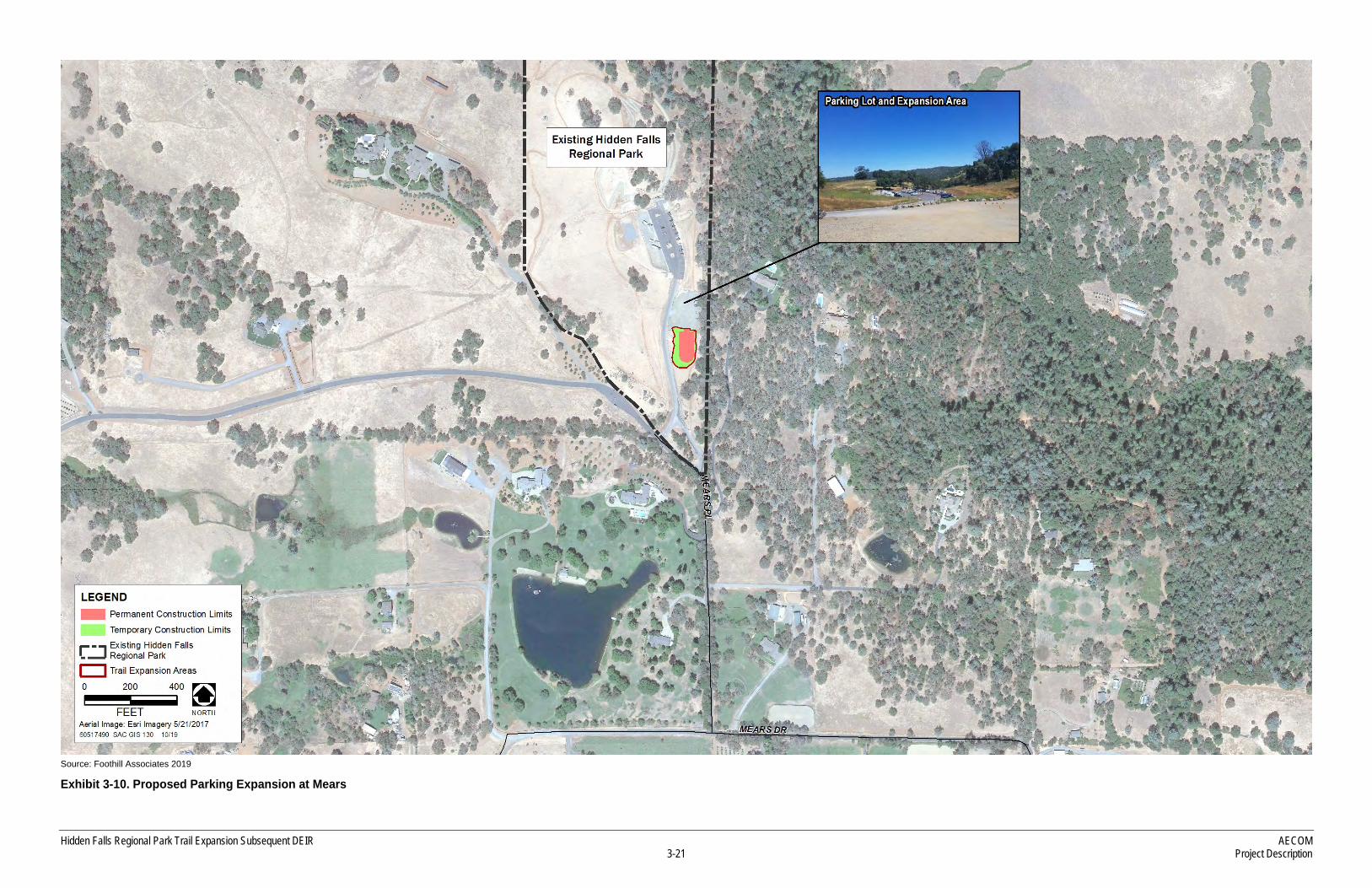
Exhibit 3-10. Proposed Parking Expansion at Mears

AECOM Hidden Falls Regional Park Trail Expansion Subsequent DEIR Project Description 3-22
This page intentionally left blank

Hidden Falls Regional Park Trail Expansion Subsequent DEIR AECOM 3-23 Project Description
This system requires visitors to obtain reservations online prior to arriving at the park. Since the system was installed, the number of vehicle trips on the local roadways has significantly decreased, making for a better visitor experience and reducing the impact on local residents.
The County is planning to expand the Mears Place overflow parking area for up to 25 automobile spaces as a part of the expansion process. Exhibit 3-10 provides a conceptual parking layout for the site. The additional gravel area for the parking spaces would be added adjacent to the existing overflow gravel parking area. The original approval in 2010 added up to 12 additional equestrian parking spaces at the Mears parking area. Equestrian parking spaces were added and no additional horse trailer spaces are planned for the Mears entrance with the proposed project. The final design and construction will comply with the County’s thematic/stylistic (rustic) design guidelines for HFRP. The existing overflow parking area will remain in place.
GARDEN BAR ROAD
The Garden Bar Road entrance is currently used by neighboring property owners who access their property via the entrance, County employees, maintenance trucks, utility providers, and fire and law enforcement personnel. The existing CUP for HFRP allows for a parking area at the western end of the park that would be accessed via Garden Bar Road. Although three phases of development for the Garden Bar entrance and parking area were approved in 2010, the improvements have not yet been constructed and the Garden Bar entrance is not currently open to the general public. Table 3-2 provides an overview of the proposed revised phasing for the Garden Bar Road entrance. The 2010 Certified EIR contained a detailed phasing plan to develop parking in this area that included within Phase 1 a public access gate, connecting roadway to the existing access road, fencing and cattle guards on the access road, along with a parking area. Phase 1 as described in the CUP included access for occasional classroom-sized groups to the site through the Garden Bar entrance with an appointment.
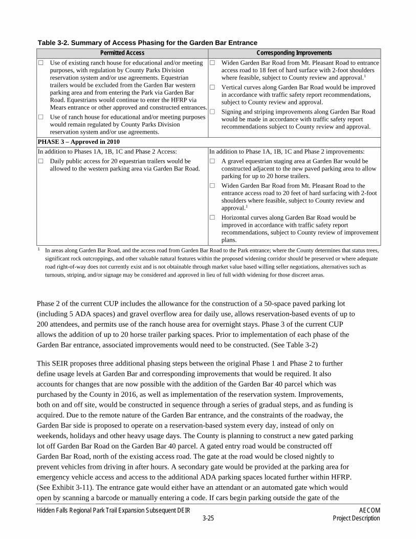
Table 3-2. Summary of Access Phasing for the Garden Bar Entrance Permitted Access Corresponding Improvements
PHASE 1 – Approved in 2010 (but proposed to be modified by the Proposed Project) (Garden Bar portions for Phase 1 proposed to be superseded by Phases 1A, 1B, & 1C, as defined below) � Trail and emergency access system would be completed
throughout the Park and opened for daily public use via existing Mears entrance (Completed)
� Daily public vehicle access would be restricted to existing Mears entrance (Completed)
� Mears parking area would be expanded from 55 parking spaces to up to 82 parking spaces (i.e., up to 25 additional paved stalls and 12 additional truck and trailer spaces) including relocating the adjacent helistop. (Completed)
� Garden Bar entrance would continue to be used by County employees, tenants, contractors, consultants, utility providers, maintenance trucks, and fire and law enforcement personnel without additional improvements (Ongoing)
� Development of existing ranch house may proceed during Phase 1 (Not yet Completed)
� Occasional classroom sized groups would be permitted to access site through Garden Bar entrance on appointment basis (gates would be opened and closed behind groups) (Not yet occurring)
� Prior to allowance of classroom sized groups, a new public access gate and approximately 200 feet of connecting road to existing access road would be constructed at the intersection of Garden Bar Road near the existing access road. (Not yet completed)
� Prior to allowance of classroom sized groups, a 48-inch-high 12.5-gauge woven wire field fence would be constructed along both sides of access road between Garden Bar Road and Park entrance (as applicable per the terms of the 2003 Purchase and Sale Agreement with the Spears family). (Not yet completed)
� Prior to allowance of classroom sized groups, two cattle guards would be installed at each end of the access road between Garden Bar Road and the Park entrance (as applicable per the terms of the 2003 Purchase and Sale Agreement with the Spears family). (Not yet completed)
� Up to 25 additional paved parking stalls and up to 12 additional equestrian parking stalls may be developed at the existing Mears entrance. (Completed)

AECOM Hidden Falls Regional Park Trail Expansion Subsequent DEIR Project Description 3-24
Table 3-2. Summary of Access Phasing for the Garden Bar Entrance Permitted Access Corresponding Improvements
� A handicap-placard-only parking area may be constructed near the emergency access bridge (Bridge #1, Salmon Run Bridge). Park use would be regulated through the Placer County Parks Division reservation system. (Not yet Completed)
PHASE 1A – Proposed � Garden Bar 40 entrance improved to allow 25 automobile
parking spaces and 5 ADA spaces (Public access allowed only on weekends/holidays/high volume days. Reservation required. Parking spaces only allowed one turn-over per day.
� Improved signage and pavement markings added on Garden Bar Road
� Provide drivable 12’ fire access road reaching from Garden Bar parking area into park as far as reasonably possible
� Provide CAL FIRE and Knox padlocks on all access gates � Provide Helicopter landing zone near Garden Bar western
entrance to HFRP (this landing zone is currently in place and verified per CAL FIRE field visit on January 30, 2019)
� The new Garden Bar vehicle parking areas shall provide designated parking stalls and maintain clear fire access lanes of 20’, meet fire equipment turning radius, and be able to support 75,000 pounds load rating
� Vertical clearances along trails and fire access lanes shall be pruned to a minimum of 15’ 0”. Vertical clearances shall apply to the planned covered bridge over Raccoon Creek that was approved in 2010
� Trails shall provide directional signage to guide park users and emergency personnel to points of interest and escape routes (trail signage is in place within existing HFRP)
� Placer County Fire Department/CAL FIRE shall be given room for an information kiosk for use during peak days for distribution of safety information.
� Defensible space standards shall be met pursuant to PRC 4291. Defensible space shall be increased as necessary in consultation with Placer County Fire Department staff to account for vegetation types and slopes.
� A 12,000 gallon water tank and hydrant shall be maintained near the Garden Bar parking area
� Portable toilets made available until Phase 1C PHASE 1B – Proposed � Number of Garden Bar 40 parking spaces remains the same
as in Phase 1A, but public access allowed on a daily basis. Reservation required 7 days/week. Parking spaces may turn over more than once/day. Special events can occur, but total amount of parking spaces utilized at any given time cannot exceed 30.
In addition to Phase 1A Improvements: � Pull-outs along Garden Bar Road
PHASE 1C – Proposed � Informal overflow areas at Garden Bar 40 parking area and
near existing ranch house to accommodate a 200-person event in addition to 30 reservation-based spaces. Special Events limited to 6 days per year.
In addition to Phase 1B Improvements: � Special Event Permit Application (SEPA) approval from
County Parks required. � Construction of Permanent restrooms and septic system (or
vault system if adequate well water is not available) PHASE 2 – Approved in 2010 In addition to Phase 1A, 1B, and 1C Access: � Expansion of the Garden Bar parking area to 50 paved
automobile parking spaces.
In addition to Phase 1A, 1B and 1C Improvements: � Garden Bar 40 parking area would be expanded to include
50-stall paved parking lot.
Hidden Falls Regional Park Trail Expansion Subsequent DEIR AECOM 3-25 Project Description
Table 3-2. Summary of Access Phasing for the Garden Bar Entrance Permitted Access Corresponding Improvements
� Use of existing ranch house for educational and/or meeting purposes, with regulation by County Parks Division reservation system and/or use agreements. Equestrian trailers would be excluded from the Garden Bar western parking area and from entering the Park via Garden Bar Road. Equestrians would continue to enter the HFRP via Mears entrance or other approved and constructed entrances.
� Use of ranch house for educational and/or meeting purposes would remain regulated by County Parks Division reservation system and/or use agreements.
� Widen Garden Bar Road from Mt. Pleasant Road to entrance access road to 18 feet of hard surface with 2-foot shoulders where feasible, subject to County review and approval.1
� Vertical curves along Garden Bar Road would be improved in accordance with traffic safety report recommendations, subject to County review and approval.
� Signing and striping improvements along Garden Bar Road would be made in accordance with traffic safety report recommendations subject to County review and approval.
PHASE 3 – Approved in 2010 In addition to Phases 1A, 1B, 1C and Phase 2 Access: � Daily public access for 20 equestrian trailers would be
allowed to the western parking area via Garden Bar Road.
In addition to Phase 1A, 1B, 1C and Phase 2 improvements: � A gravel equestrian staging area at Garden Bar would be
constructed adjacent to the new paved parking area to allow parking for up to 20 horse trailers.
� Widen Garden Bar Road from Mt. Pleasant Road to the entrance access road to 20 feet of hard surfacing with 2-foot shoulders where feasible, subject to County review and approval.1
� Horizontal curves along Garden Bar Road would be improved in accordance with traffic safety report recommendations, subject to County review of improvement plans.
1 In areas along Garden Bar Road, and the access road from Garden Bar Road to the Park entrance; where the County determines that status trees, significant rock outcroppings, and other valuable natural features within the proposed widening corridor should be preserved or where adequate road right-of-way does not currently exist and is not obtainable through market value based willing seller negotiations, alternatives such as turnouts, striping, and/or signage may be considered and approved in lieu of full width widening for those discreet areas.
Phase 2 of the current CUP includes the allowance for the construction of a 50-space paved parking lot (including 5 ADA spaces) and gravel overflow area for daily use, allows reservation-based events of up to 200 attendees, and permits use of the ranch house area for overnight stays. Phase 3 of the current CUP allows the addition of up to 20 horse trailer parking spaces. Prior to implementation of each phase of the Garden Bar entrance, associated improvements would need to be constructed. (See Table 3-2)
This SEIR proposes three additional phasing steps between the original Phase 1 and Phase 2 to further define usage levels at Garden Bar and corresponding improvements that would be required. It also accounts for changes that are now possible with the addition of the Garden Bar 40 parcel which was purchased by the County in 2016, as well as implementation of the reservation system. Improvements, both on and off site, would be constructed in sequence through a series of gradual steps, and as funding is acquired. Due to the remote nature of the Garden Bar entrance, and the constraints of the roadway, the Garden Bar side is proposed to operate on a reservation-based system every day, instead of only on weekends, holidays and other heavy usage days. The County is planning to construct a new gated parking lot off Garden Bar Road on the Garden Bar 40 parcel. A gated entry road would be constructed off Garden Bar Road, north of the existing access road. The gate at the road would be closed nightly to prevent vehicles from driving in after hours. A secondary gate would be provided at the parking area for emergency vehicle access and access to the additional ADA parking spaces located further within HFRP. (See Exhibit 3-11). The entrance gate would either have an attendant or an automated gate which would open by scanning a barcode or manually entering a code. If cars begin parking outside the gate of the
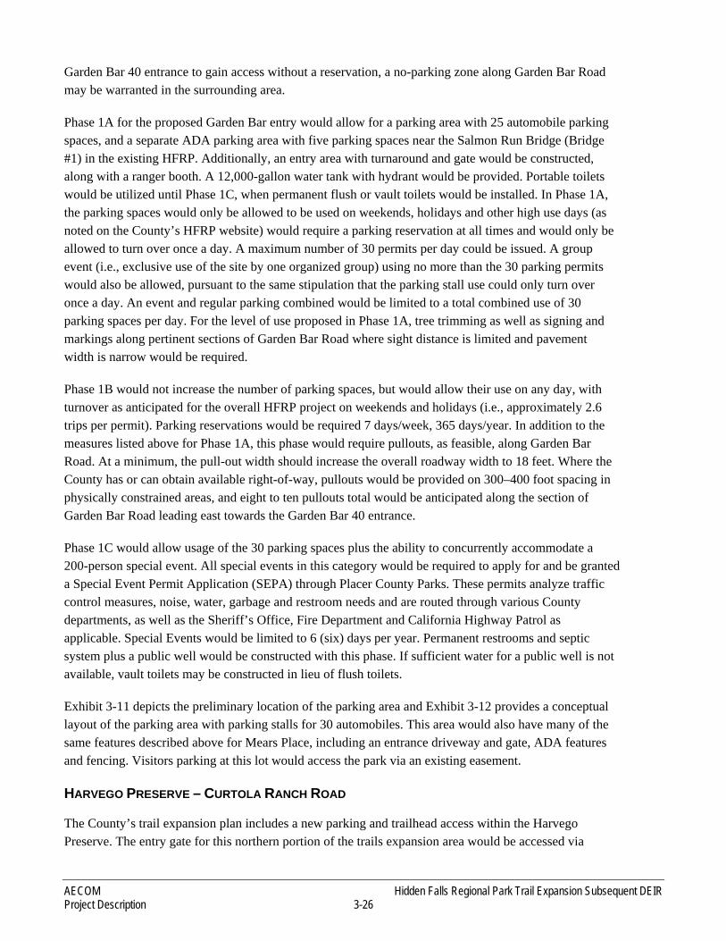
AECOM Hidden Falls Regional Park Trail Expansion Subsequent DEIR Project Description 3-26
Garden Bar 40 entrance to gain access without a reservation, a no-parking zone along Garden Bar Road may be warranted in the surrounding area.
Phase 1A for the proposed Garden Bar entry would allow for a parking area with 25 automobile parking spaces, and a separate ADA parking area with five parking spaces near the Salmon Run Bridge (Bridge #1) in the existing HFRP. Additionally, an entry area with turnaround and gate would be constructed, along with a ranger booth. A 12,000-gallon water tank with hydrant would be provided. Portable toilets would be utilized until Phase 1C, when permanent flush or vault toilets would be installed. In Phase 1A, the parking spaces would only be allowed to be used on weekends, holidays and other high use days (as noted on the County’s HFRP website) would require a parking reservation at all times and would only be allowed to turn over once a day. A maximum number of 30 permits per day could be issued. A group event (i.e., exclusive use of the site by one organized group) using no more than the 30 parking permits would also be allowed, pursuant to the same stipulation that the parking stall use could only turn over once a day. An event and regular parking combined would be limited to a total combined use of 30 parking spaces per day. For the level of use proposed in Phase 1A, tree trimming as well as signing and markings along pertinent sections of Garden Bar Road where sight distance is limited and pavement width is narrow would be required.
Phase 1B would not increase the number of parking spaces, but would allow their use on any day, with turnover as anticipated for the overall HFRP project on weekends and holidays (i.e., approximately 2.6 trips per permit). Parking reservations would be required 7 days/week, 365 days/year. In addition to the measures listed above for Phase 1A, this phase would require pullouts, as feasible, along Garden Bar Road. At a minimum, the pull-out width should increase the overall roadway width to 18 feet. Where the County has or can obtain available right-of-way, pullouts would be provided on 300–400 foot spacing in physically constrained areas, and eight to ten pullouts total would be anticipated along the section of Garden Bar Road leading east towards the Garden Bar 40 entrance.
Phase 1C would allow usage of the 30 parking spaces plus the ability to concurrently accommodate a 200-person special event. All special events in this category would be required to apply for and be granted a Special Event Permit Application (SEPA) through Placer County Parks. These permits analyze traffic control measures, noise, water, garbage and restroom needs and are routed through various County departments, as well as the Sheriff’s Office, Fire Department and California Highway Patrol as applicable. Special Events would be limited to 6 (six) days per year. Permanent restrooms and septic system plus a public well would be constructed with this phase. If sufficient water for a public well is not available, vault toilets may be constructed in lieu of flush toilets.
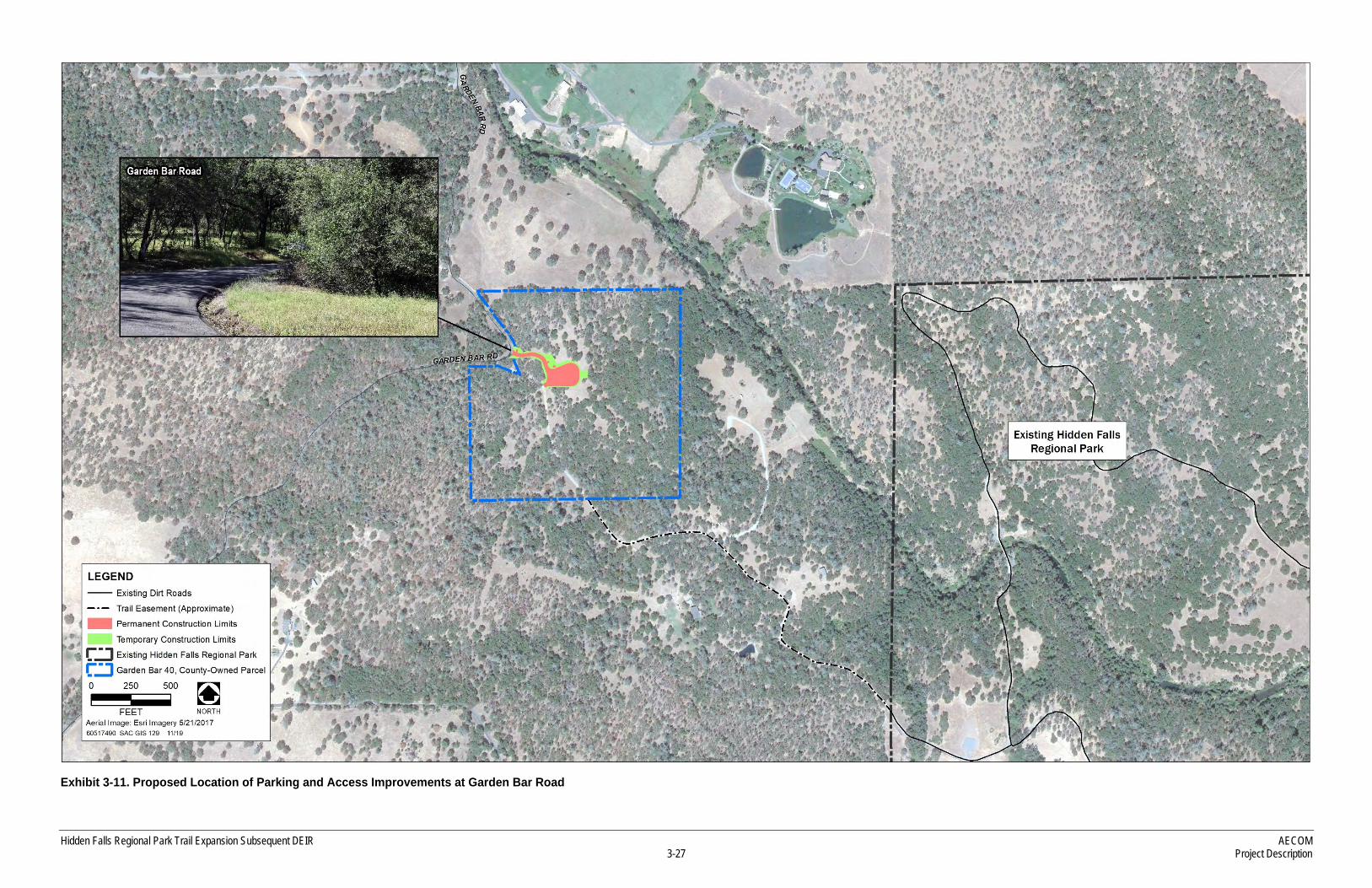
Exhibit 3-11 depicts the preliminary location of the parking area and Exhibit 3-12 provides a conceptual layout of the parking area with parking stalls for 30 automobiles. This area would also have many of the same features described above for Mears Place, including an entrance driveway and gate, ADA features and fencing. Visitors parking at this lot would access the park via an existing easement.
HARVEGO PRESERVE – CURTOLA RANCH ROAD
The County’s trail expansion plan includes a new parking and trailhead access within the Harvego Preserve. The entry gate for this northern portion of the trails expansion area would be accessed via
Hidden Falls Regional Park Trail Expansion Subsequent DEIR AECOM 3-27 Project Description
Exhibit 3-11. Proposed Location of Parking and Access Improvements at Garden Bar Road

AECOM Hidden Falls Regional Park Trail Expansion Subsequent DEIR Project Description 3-28
This page intentionally left blank

Hidden Falls Regional Park Trail Expansion Subsequent DEIR AECOM 3-29 Project Description
Exhibit 3-12. Garden Bar Conceptual Parking

AECOM Hidden Falls Regional Park Trail Expansion Subsequent DEIR Project Description 3-30
This page intentionally left blank

Hidden Falls Regional Park Trail Expansion Subsequent DEIR AECOM 3-31 Project Description
Source: Foothill Associates 2019
Exhibit 3-13. Proposed Location of Parking Improvements at Harvego Preserve/Curtola Ranch Road

AECOM Hidden Falls Regional Park Trail Expansion Subsequent DEIR Project Description 3-32
This page intentionally left blank
Hidden Falls Regional Park Trail Expansion Subsequent DEIR AECOM 3-33 Project Description
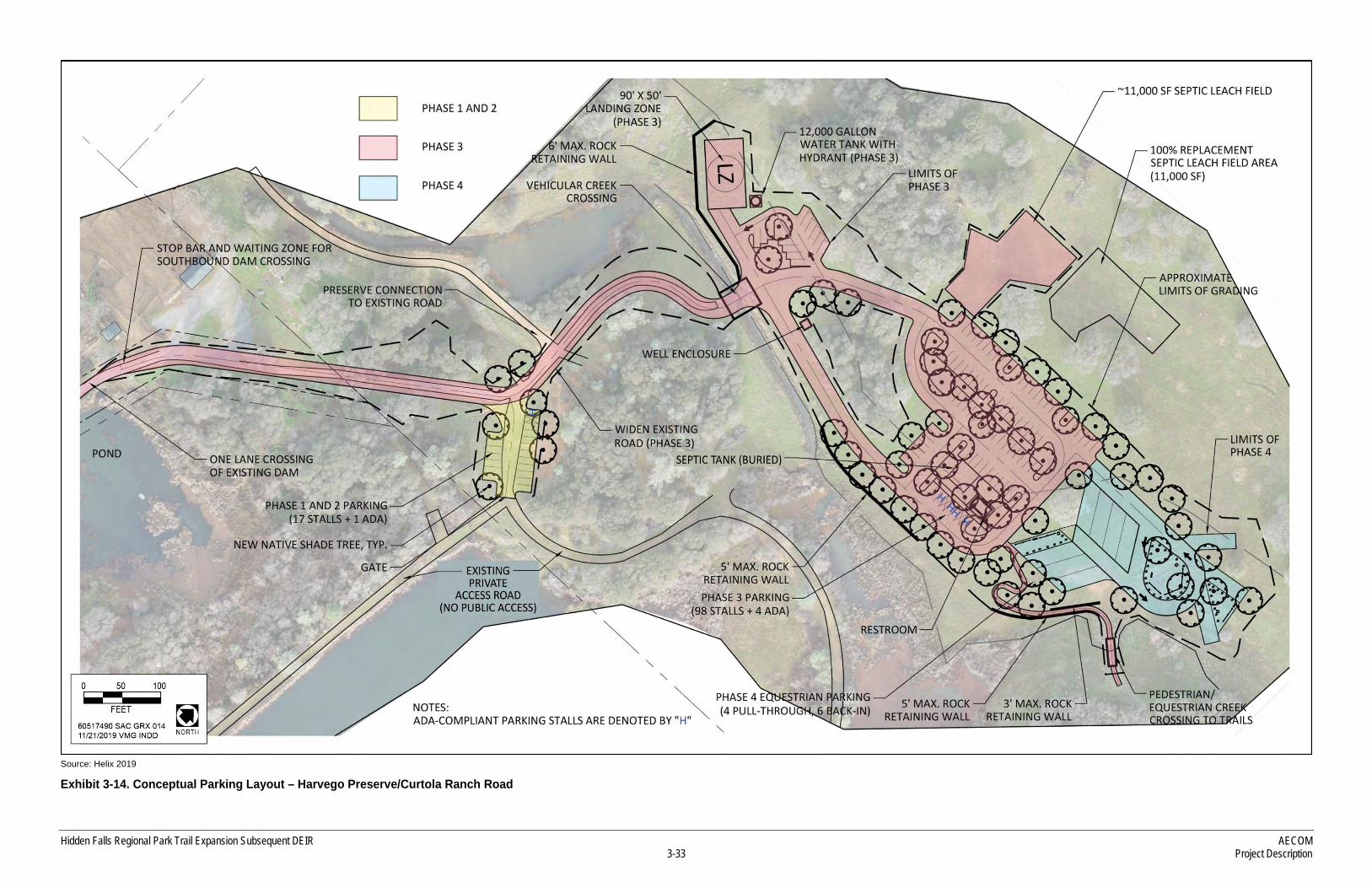
Source: Helix 2019
Exhibit 3-14. Conceptual Parking Layout – Harvego Preserve/Curtola Ranch Road

AECOM Hidden Falls Regional Park Trail Expansion Subsequent DEIR Project Description 3-34
This page intentionally left blank
Hidden Falls Regional Park Trail Expansion Subsequent DEIR AECOM 3-35 Project Description
Auburn Valley Road and Curtola Ranch Road. County access via Auburn Valley Road is provided by an offer of public dedication that the County has not accepted to date. Exhibit 3-13 shows the proposed location of the parking area within the preserve and Exhibit 3-14 provides a preliminary schematic design for the layout of the parking areas. The County is planning a phased approach that would need to be consistent with the easement along Curtola Ranch Road (Appendix B). This easement (Doc-2011-0045644) currently stipulates that the PLT and County may allow general public use of the access easement on Curtola Ranch Road only after an all-weather roadway surface of not less than 20 feet in width is constructed. Phasing would proceed consistent with easement terms in effect at the time of development.
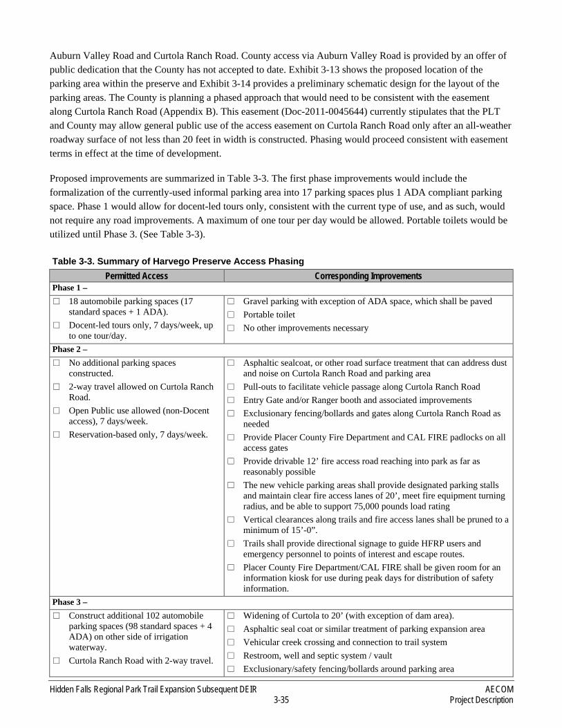
Proposed improvements are summarized in Table 3-3. The first phase improvements would include the formalization of the currently-used informal parking area into 17 parking spaces plus 1 ADA compliant parking space. Phase 1 would allow for docent-led tours only, consistent with the current type of use, and as such, would not require any road improvements. A maximum of one tour per day would be allowed. Portable toilets would be utilized until Phase 3. (See Table 3-3).
Table 3-3. Summary of Harvego Preserve Access Phasing Permitted Access Corresponding Improvements
Phase 1 – � 18 automobile parking spaces (17
standard spaces + 1 ADA). � Docent-led tours only, 7 days/week, up
to one tour/day.
� Gravel parking with exception of ADA space, which shall be paved � Portable toilet � No other improvements necessary
Phase 2 – � No additional parking spaces
constructed. � 2-way travel allowed on Curtola Ranch
Road. � Open Public use allowed (non-Docent
access), 7 days/week. � Reservation-based only, 7 days/week.
� Asphaltic sealcoat, or other road surface treatment that can address dust and noise on Curtola Ranch Road and parking area
� Pull-outs to facilitate vehicle passage along Curtola Ranch Road � Entry Gate and/or Ranger booth and associated improvements � Exclusionary fencing/bollards and gates along Curtola Ranch Road as
needed � Provide Placer County Fire Department and CAL FIRE padlocks on all
access gates � Provide drivable 12’ fire access road reaching into park as far as
reasonably possible � The new vehicle parking areas shall provide designated parking stalls
and maintain clear fire access lanes of 20’, meet fire equipment turning radius, and be able to support 75,000 pounds load rating
� Vertical clearances along trails and fire access lanes shall be pruned to a minimum of 15’-0”.
� Trails shall provide directional signage to guide HFRP users and emergency personnel to points of interest and escape routes.
� Placer County Fire Department/CAL FIRE shall be given room for an information kiosk for use during peak days for distribution of safety information.
Phase 3 – � Construct additional 102 automobile
parking spaces (98 standard spaces + 4 ADA) on other side of irrigation waterway.
� Curtola Ranch Road with 2-way travel.
� Widening of Curtola to 20’ (with exception of dam area). � Asphaltic seal coat or similar treatment of parking expansion area � Vehicular creek crossing and connection to trail system � Restroom, well and septic system / vault � Exclusionary/safety fencing/bollards around parking area
AECOM Hidden Falls Regional Park Trail Expansion Subsequent DEIR Project Description 3-36
Table 3-3. Summary of Harvego Preserve Access Phasing Permitted Access Corresponding Improvements
� Open Public use allowed, 7 days/week. � Reservation-based only on weekends,
holidays and other peak use days. No reservation required during weekdays.
� Provide helicopter landing zone near parking area, in consultation with Placer County Fire Department staff
� A 12,000 gallon water tank and hydrant shall be maintained near the parking area
Phase 4 – � Addition of 10 equestrian spaces. � Other characteristics from Phase 3
unchanged.
� No additional road improvements � Gravel parking lot expansion for equestrian use. � Hitching posts, watering troughs, and mounting blocks
Source: Placer County 2019 Phase 2 would allow for the 18 spaces to be reserved daily, with a turnover rate of approximately 2.6 trips/permit. For this level of use, pullouts would be required along Curtola Ranch Road, as feasible. The pullouts would be installed at key locations where physical constraints make it possible to widen the road. At a minimum, the pull-out width should increase the total roadway width to 18 feet and should be provided on 300–600 foot spacing. Additionally, an entry gate and ranger kiosk would be constructed, and Curtola Ranch Road and the parking area would be either all-weather surfaced or paved to reduce dust and noise. Exclusionary fencing and or bollards, as well as gates at private entries along Curtola Ranch Road would be provided as needed. Tree canopy along the road would be pruned up to allow 15 feet of clearance, per fire regulations. Changes to existing easement terms would need to be made prior to allowance of the proposed Phase 2 uses.
Phase 3 would add an additional 98 automobile plus 4 ADA parking spaces. For this to occur, Curtola Ranch Road would need to be widened to 20 feet (except for over an existing dam, where staging locations at each end of the one-lane section would be available to allow waiting cars to yield to oncoming cars). This phase would also include construction of a landing zone for emergency response, a 12,000-gallon water tank with hydrant, well, restroom and septic system, stream crossings and exclusionary/safety fencing/bollards around the parking area. As with the Garden Bar site, the type of restroom (flush or vault) would be dependent upon the availability of well water.
Phase 4 would include expansion of the parking lot to accommodate up to 10 equestrian parking spaces as well as equestrian related amenities such as hitching posts, watering troughs and mounting blocks. No additional improvements to the roadway beyond those implemented in Phase 3 would be required.
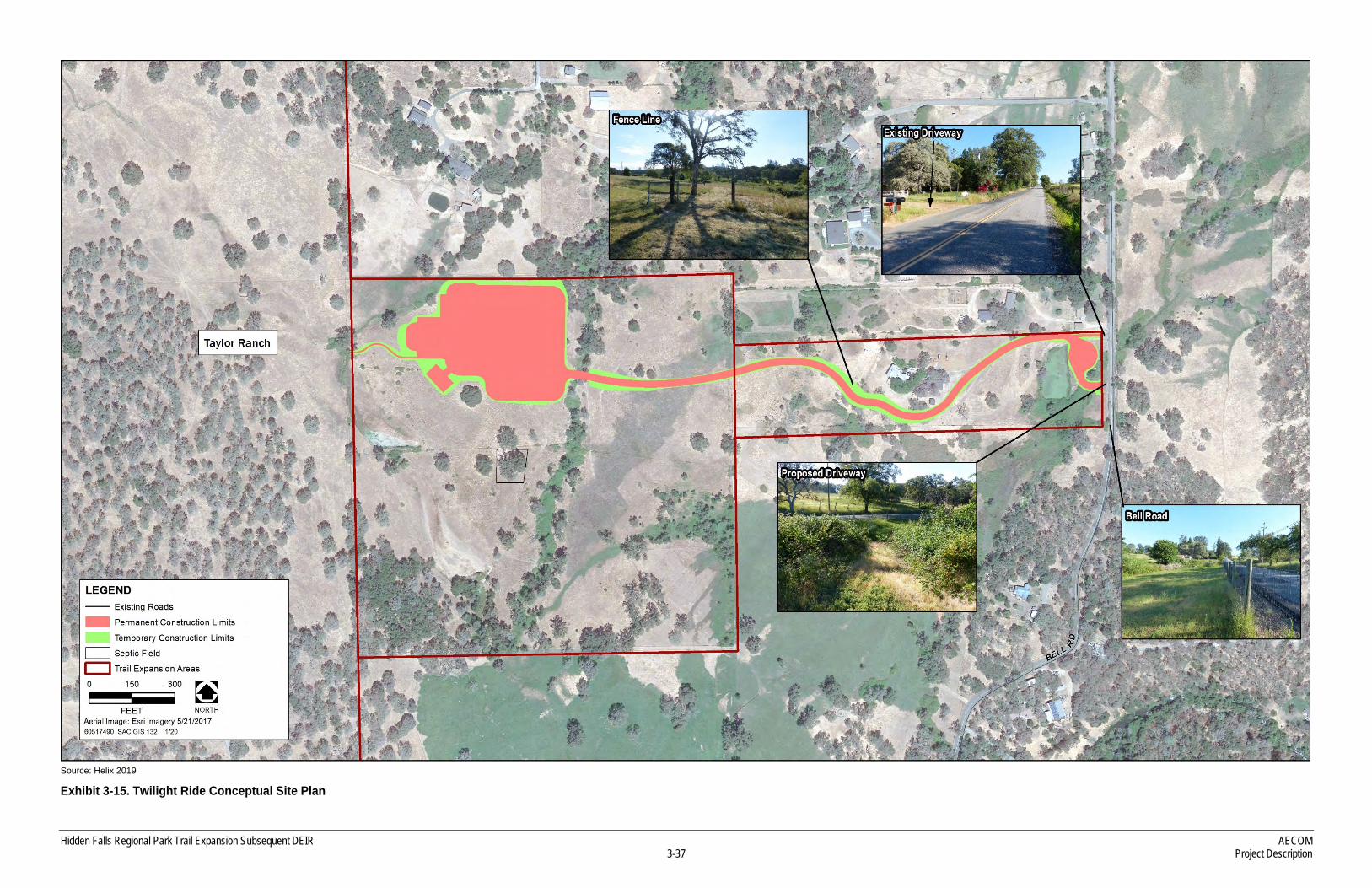
TWILIGHT RIDE
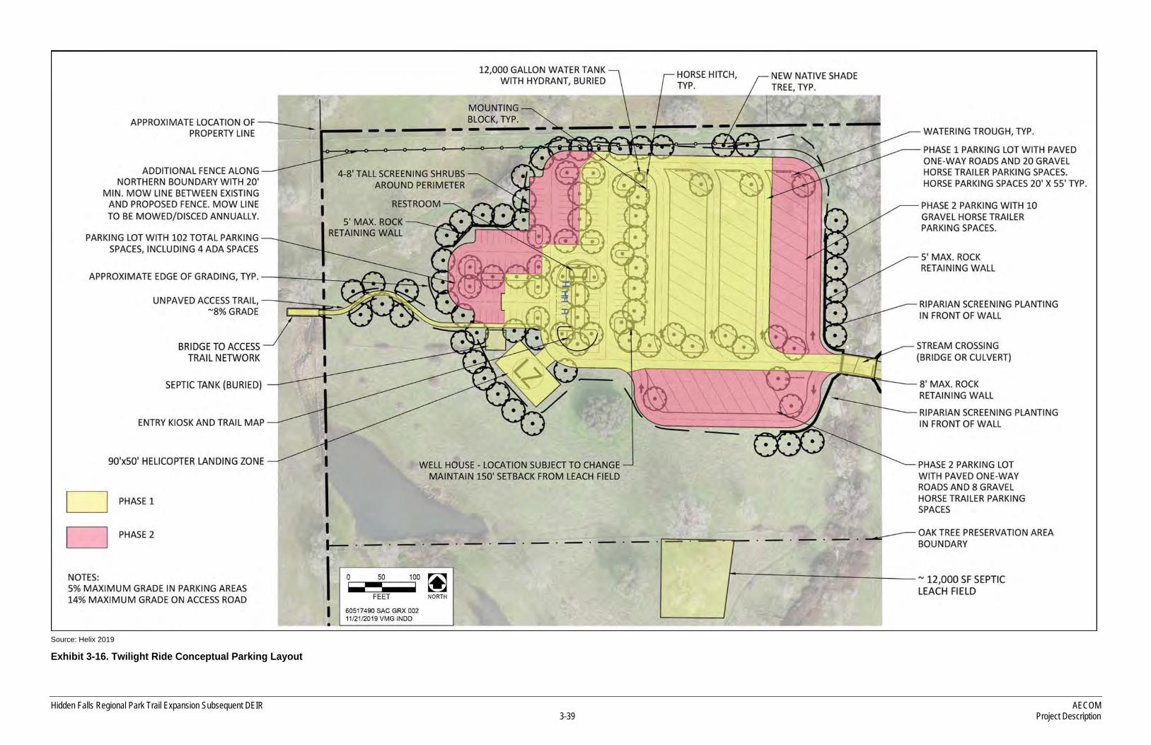
The County has entered into a Purchase and Sale Agreement for the 50-acre privately owned Twilight Ride property located at 5345 Bell Road, adjacent to the PLT-owned Taylor Ranch. This property would provide parking accessible directly off of Bell Road. Exhibit 3-15 shows the proposed entrance off Bell Road, the access driveway connecting to the parking area, and the parking area in relationship to the rest of the site. Exhibit 3-16 provides a preliminary design depicting automobile parking and the equestrian staging area. At full build out of all phases, the parcel would provide 140 parking spaces, with 102 spaces dedicated to automobiles and 38 spaces for equestrian trailers.
Hidden Falls Regional Park Trail Expansion Subsequent DEIR AECOM 3-37 Project Description
Source: Helix 2019
Exhibit 3-15. Twilight Ride Conceptual Site Plan

AECOM Hidden Falls Regional Park Trail Expansion Subsequent DEIR Project Description 3-38
This page intentionally left blank
Hidden Falls Regional Park Trail Expansion Subsequent DEIR AECOM 3-39 Project Description
Source: Helix 2019
Exhibit 3-16. Twilight Ride Conceptual Parking Layout

AECOM Hidden Falls Regional Park Trail Expansion Subsequent DEIR Project Description 3-40
This page intentionally left blank
Hidden Falls Regional Park Trail Expansion Subsequent DEIR AECOM 3-41 Project Description
The Twilight Ride property consists of a 10-acre parcel adjacent to Bell Road, and a connecting 40-acre parcel which abuts Taylor Ranch. Existing facilities on the property include a single-family residence with a separate garage/housing unit and other outbuildings on the 10-acre parcel, and an older storage/barn structure on the 40-acre parcel.
Parking on Twilight Ride would be proposed in two phases. Phase 1 would consist of 50 automobile parking stalls, 4 ADA parking stalls and 20 equestrian parking stalls. Also included with Phase 1 would be a helicopter landing zone, 12,000-gallon water tank with hydrant, well, restroom (either flush or vault) and septic system. If a suitable well site is not available, vault toilets would be constructed in lieu of flush toilets with a connected septic system. Improvements for this level of use would include entry road improvements (using either the stream crossing or existing entry drive), a fire truck compliant turnaround, a ranger kiosk, entrance gate, access road, a second bridge or culvert, connecting trail and stream crossings, and construction of Phase 1 of the parking lot. Both the access road and parking area would be seal coated or paved to reduce noise and dust.
Table 3-4. Summary of Twilight Ride Access Phasing Permitted Access Corresponding Improvements
Phase 1 – � 54 automobile parking spaces (50 standard
spaces + 4 ADA), and 20 equestrian spaces.
� Open Public use allowed, 7 days/week. � Reservation-based only on weekends,
holidays and other peak use days. No reservation required during weekdays.
� Entry Gate and/or Ranger booth � Entry road improvements, including stream crossings and trail
connection � A 12,000-gallon water storage tank and hydrant � Permanent restroom (flush or vault) � Septic system (if flush toilets) � Provide helicopter landing zone near parking area in consultation
with Placer County Fire Department/CAL FIRE staff � Provide CAL FIRE and Knox padlocks on all access gates � Provide drivable 12’ fire access road reaching into trails expansion
area as far as reasonably possible � The new vehicle parking areas shall provide designated parking
stalls and maintain clear fire access lanes of 20’, meet fire equipment turning radius, and be able to support 75,000 pounds load rating
� Vertical clearances along trails and fire access lanes shall be pruned to a minimum of 15’-0”.
� Trails shall provide directional signage to guide park users and emergency personnel to points of interest and escape routes
� Placer County Fire Department/CAL FIRE shall be given room for an information kiosk for use during peak days for distribution of safety information.
� Mitigation Measure - A light rescue vehicle shall be available to Placer County Fire Department/CAL FIRE to serve HFRP and the trail expansion areas, as well as the greater North Auburn/Ophir areas served by the Placer County Fire Department.
Phase 2 – � Addition of 48 automobile parking spaces
and 18 equestrian parking spaces. � Open Public use allowed, 7 days/week. � Reservation-based only on weekends,
holidays and other peak use days. No reservation required during weekdays.
� Mitigation Measure - Construct dedicated left turn lane on Bell Road meeting design standards contained in the Caltrans Highway Design Manual (HDM).
Source: Placer County 2019
AECOM Hidden Falls Regional Park Trail Expansion Subsequent DEIR Project Description 3-42
Phase 2 would add another 48 parking spaces and 18 equestrian spaces. The proposed phasing table and site plans depict the vision for public access via the Twilight Ride property.
3.5 TRAIL AND FACILITY CONSTRUCTION
Construction activities associated with the proposed improvements range from hand held tools used to trim bushes and manipulate soil to small dozers for trail construction, to heavy machinery required to grade land for creation of roadway beds, parking lots, and cranes used to place bridge components. Table 3-5 summarizes the various pieces of construction equipment anticipated for use in the creation of the proposed facilities. Conceptual site plans of the related construction activity follow the table. The following bulleted items describe the construction methods proposed for the trail and facility improvements.
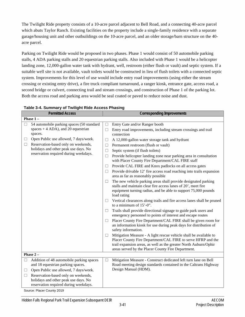
The multi-use trails would be constructed using a combination of techniques, including by hand (see Exhibit 3-17) and by using a combination of small construction equipment. Refer to Table 3-5 for a list of equipment used during construction of the proposed trails and associated project components.
Table 3-5. List of Typical Equipment to be used for Hidden Falls Regional Park Trails Expansion Proposed Facilities Equipment by Type
Trails SWECO Dozer Chainsaw Pick ATV/utility vehicle
Mini-excavator Pick Up Truck Polesaw Shovel Chipper
Parking and Amenities Large Dozer/Excavator Compactor Heavy Truck
Paver Pick Up Truck Water Truck
Access Roads (internal) Large Dozer/Excavator Compactor Paver
Pick Up Truck Heavy Truck Water Truck
Overlooks Mini-excavator Pick Up Truck
Bridge and Stream Crossings Bobcat Crane Heavy Truck Helicopter
Excavator Pick Up Truck Water Truck
Off Site Road Improvements Large Dozer/Excavator Compactor Heavy Truck
Pick Up Truck Water Truck Paver
Hidden Falls Regional Park Trail Expansion Subsequent DEIR AECOM 3-43 Project Description
Source: Placer Land Trust
Exhibit 3-17. Trail Construction Example
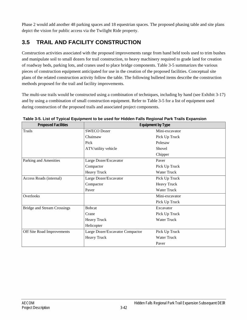
► Abutments would be constructed on Raccoon Creek to install both bridges, likely with the use of a crane or helicopter (see Exhibit 3-18). Banks would be graded to a maximum 2:1 slope aspect ratio and stream bank protection to limit erosion would be installed before construction begins. The bridge structures may be prefabricated and flown in via helicopter.
Source: Placer County
Exhibit 3-18. Bridge Placement

AECOM Hidden Falls Regional Park Trail Expansion Subsequent DEIR Project Description 3-44
► Trail width would vary depending on the type of trail. Multi-use trails would be graded to 5 feet wide (see Exhibit 3-17). Trail surfaces would be excavated using small, earth-moving equipment such as Bobcat mini excavators and SWECO dozers. Trails (and bridges) designed to accommodate emergency vehicles would be 8–12 feet wide.
► Overlooks would be constructed in the same manner as the existing overlooks within HFRP and would utilize natural colors to blend in with the environment.
► Restrooms and other buildings would be rustic in appearance and consistent with Placer County design guidelines.
► Stream crossings would be constructed at various locations by placing culverts and stabilizing the banks with riprap (see Exhibit 3-19). Rocks would be placed in ephemeral drainages to provide a level surface.
Source: Robert Sydnor
Exhibit 3-19. Typical Stream Crossing using Culvert
Hidden Falls Regional Park Trail Expansion Subsequent DEIR AECOM 3-45 Project Description
► Parking areas would require heavy equipment (e.g., bulldozers, front-end loaders) as required for clearing and grubbing, grading, and excavation. Drainage systems would be installed to collect and treat storm water on site.
► Helicopter Landing Zones would be provided at each of the parking areas to assist with emergency responses.
► Utilities – Supporting utilities would be constructed as the trail network expands, including wells for restroom facilities and fire protection, irrigation systems, sanitary sewer systems, trash containers, and emergency phone service.
► Hiking, biking and equestrian amenities would include interpretive and wayfinding signage, kiosks with informational signage, hitching posts and watering troughs, benches, picnic tables, fencing, drinking fountains and restrooms. Signage with trail etiquette would be posted at the trailheads.
ENVIRONMENTAL BEST MANAGEMENT PRACTICES
All aspects of construction would use environmental and construction best management practices to minimize environmental effects. The trail alignment would be staked in the field prior to construction so the impacts to biological resources can be avoided when feasible. Final vegetation clearance would consist of cutting, removal and disposal of vegetation within the clearing limits of the approved trail alignment to prepare the trail bed for excavation. Removed vegetation smaller than 3” in diameter would be chipped in place and used as mulch for erosion control or lopped and scattered in areas inaccessible to a chipper. Standard trail design would undulate with the topography to shed water off the trail system before it can create ruts. Whenever possible, vegetation clearing would be scheduled outside the breeding season of migratory birds, including raptors, to avoid adverse effects on nesting birds. Specimen trees greater than 5” at breast height diameter that are located within 5 feet of the clearing limits and proposed to remain would be tagged with distinctive flagging to denote a protected tree. Cut and fill slopes would be protected by stormwater best management practices (BMPs) to be outlined in a stormwater pollution prevention plan.
CONSTRUCTION TRUCK TRIPS
Construction of the trail system and associated recreational facilities is expected to generate approximately 400 delivery truck trips. However, construction-related traffic would be spread out over several years as described below in “Construction Schedule.” For Phase 1 of construction, truck traffic is expected to be approximately 10–20 percent of the total needed or 40–80 truck trips. Construction activities would generally take place Monday through Saturday, although construction activities that are inaudible from areas outside the trail expansion areas may be permitted on Sundays. Consistent with existing County Ordinances, from Monday through Friday, work would be allowed between 6 a.m. and 8 p.m. during daylight savings time and between 7 a.m. and 8 p.m. during standard time. Construction activities would be allowed between 8 a.m. and 6 p.m. on Saturdays.
CONSTRUCTION SCHEDULE
The trails and other features described above would be constructed over multiple years as funding allows. Trail construction would coincide with favorable weather conditions. Vegetation clearing would be scheduled outside of the breeding season for raptors and other migratory birds in the winter preceding construction, whenever possible. The bridges would be built during dry periods of the year when stream flows are lower.
AECOM Hidden Falls Regional Park Trail Expansion Subsequent DEIR Project Description 3-46
3.6 OPERATION AND MAINTENANCE
The proposed trail system and recreational facilities would be designed to minimize maintenance requirements; however, some regular maintenance of the trails and ancillary facilities would be required. Land management activities would be conducted by a combination of the PLT and the County. This would include forest management/fuel load reduction, including clearing defensible spaces, creating fire breaks, and maintaining access roads. Agricultural uses would continue to operate and include grazing, livestock watering and feeding, and ranch road maintenance. As with the existing HFRP, maintenance activities of the trails, access and parking areas would be conducted consistent with the Vegetation, Fuels, and Range Management Plan for HFRP (2007). This plan identifies methods for modifying vegetation to reduce existing fuel load and lower the chance a fire would start within trails, access and parking areas and move outside these areas. Initial removal of excess fuels would be accomplished by some combination of mechanical equipment and hand tools. Use of herbicides and grazing by livestock would be used for long-term maintenance. Fuel breaks and defensible spaces would be incorporated into the trail expansion areas through thinning vegetation around parking lots and near certain trail segments and property lines. The PLT has constructed both a 90-acre and 30-acre fuel break on the Harvego Preserve. Vegetation management within the PLT-owned portions of the properties would adhere to the management plans for each of the respective properties. PLT has stated in public meetings and has language on their website that notes the properties they own will continue to use cattle grazing as a fuel management tool.
Trail maintenance would include selectively clearing vegetation; regrading trail tread; removing loose rocks, roots, and dead trees; and replacing trail surface material, if necessary. Localized spraying of herbicide may be required along the trail corridor to prevent vegetation from overgrowing the tread. Herbicides would be applied by County staff members or County contractors certified in proper herbicide/pesticide application. Trail operations and maintenance were described in the 2010 Certified EIR. All proposed operation and maintenance activities are expected to be similar to those currently undertaken in the existing HFRP and would be conducted by County staff, County contractors, volunteers, and user groups.
The County has contracted with California Land Management, Inc. (CLM) to provide ranger services at the existing HFRP. The County would expand this contract to provide rangers within the expansion areas to engage and educate the public, enforce permit restrictions, provide traffic control, and serve as the eyes and ears for law enforcement and emergency medical services.
3.6.1 TRAFFIC MANAGEMENT
RESERVATION SYSTEM
To minimize traffic impacts near the established parking lot on Mears Place, the County has developed strategies to electronically alert visitors to parking availability before they arrive at the site. In addition to the existing web-cam that shows updated views of the Mears parking area every few minutes, the County regularly provides website updates and social media messages to alert visitors before they get in their cars to come visit the park. The County most recently established a reservation system at the existing Mears Place entrance on September 1, 2017 for weekends, holidays and other high-use days. The reservations system was established so that people can obtain a parking reservation online prior to arriving at the park. In this manner, they arrive with a guaranteed parking space, and extra traffic on the local roads from people being turned away at the gate has been greatly

Hidden Falls Regional Park Trail Expansion Subsequent DEIR AECOM 3-47 Project Description
reduced. The operational techniques applied at the Mears entrance would be employed at the Garden Bar 40, Harvego, and Twilight Ride entrances to the park in order to minimize trips associated with vehicle turn-backs.
At this time, reservations are required only on high volume days (weekends, holidays, as well as other days specified on the website). Generally, no reservation or charges apply on Mondays through Fridays (unless the day falls on a holiday or high volume day). The existing reservation system will be adaptively managed for use patterns in the future that may result in the issuance of weekday permits. The current cost for parking is variable based on time of arrival as shown below and these charges are subject to adjustment by the Placer County Board of Supervisors.
► $8.00 per vehicle – full day (sunrise to sunset) ► $4.00 per vehicle – partial day (morning or afternoon)
The horse trailer area is currently reserved in the same way as the automobile area (same prices during the same peak days), but it has its own separate quota of reservations to make sure the entire gravel horse trailer area is kept just for equestrian trailered vehicles.
USAGE AND VISITOR DEMOGRAPHIC
Placer County currently contracts with California Land Management, Inc. (CLM) to provide ranger services at HFRP. Data obtained from the CLM Ranger log for a five month window during the peak season at the Mears lot indicated that a maximum of 148 vehicles used the facility on a single day during March through July of 2018 (see Table 3-6). This total illustrates the turnover of parking spaces from the morning session, through full-day reservations and into the afternoon permit window.
Table 3-6. Examples of Peak Period Vehicle Registration at Mears Entrance
Date Highest Daily Vehicle Reservation Check In
March 31, 2018 127 April 14, 2018 140 May 13, 2018 147 June 17, 2018 148 July 1, 2018 91
Source: Placer County Parks Division, 2018
Records review conducted by the County Parks Division found that 12,018 visitors used the HFRP reservation system over an 18 month period from February 2017 through July 2018. Of the 12,018 visitors that came during the weekends, holidays and other peak use days, approximately 37 percent (4,504 visitors) were local residents from Placer County. See Table 3-7 for a breakdown of visitors according to residency during the weekends. Data collected from informal surveys of visitors on weekdays showed that the majority of people are local residents.
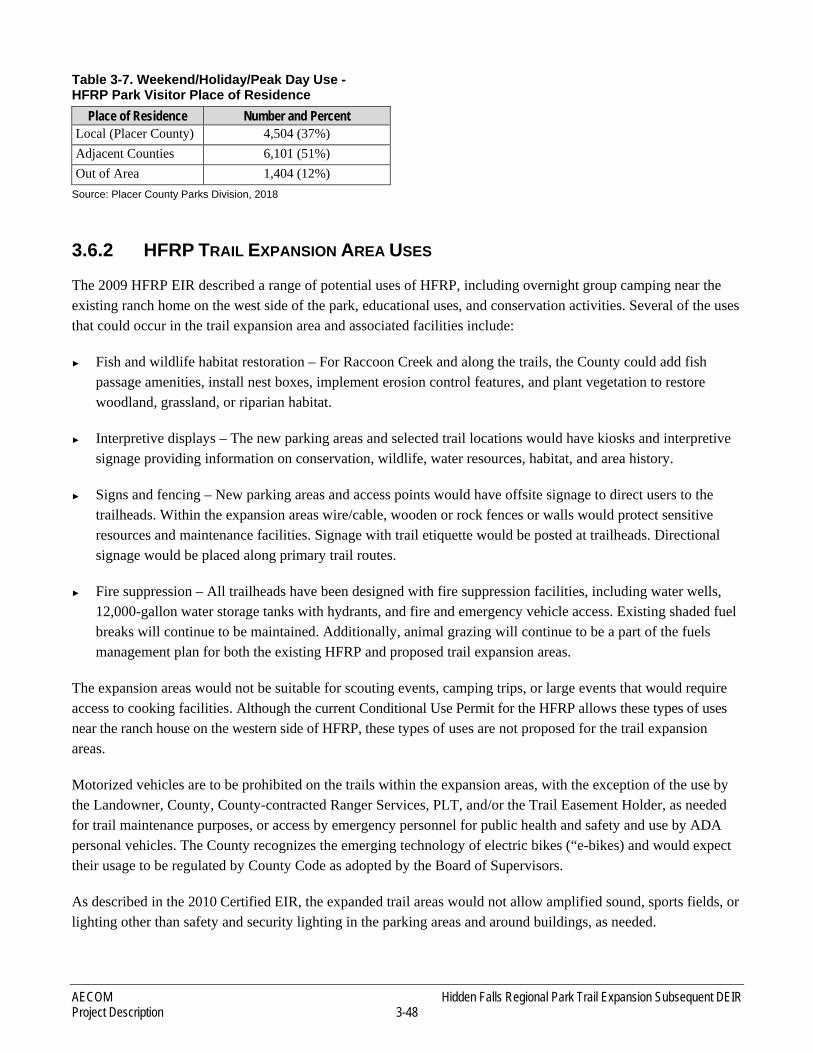
AECOM Hidden Falls Regional Park Trail Expansion Subsequent DEIR Project Description 3-48
Table 3-7. Weekend/Holiday/Peak Day Use - HFRP Park Visitor Place of Residence
Place of Residence Number and Percent Local (Placer County) 4,504 (37%) Adjacent Counties 6,101 (51%) Out of Area 1,404 (12%)
Source: Placer County Parks Division, 2018
3.6.2 HFRP TRAIL EXPANSION AREA USES
The 2009 HFRP EIR described a range of potential uses of HFRP, including overnight group camping near the existing ranch home on the west side of the park, educational uses, and conservation activities. Several of the uses that could occur in the trail expansion area and associated facilities include:
► Fish and wildlife habitat restoration – For Raccoon Creek and along the trails, the County could add fish passage amenities, install nest boxes, implement erosion control features, and plant vegetation to restore woodland, grassland, or riparian habitat.
► Interpretive displays – The new parking areas and selected trail locations would have kiosks and interpretive signage providing information on conservation, wildlife, water resources, habitat, and area history.
► Signs and fencing – New parking areas and access points would have offsite signage to direct users to the trailheads. Within the expansion areas wire/cable, wooden or rock fences or walls would protect sensitive resources and maintenance facilities. Signage with trail etiquette would be posted at trailheads. Directional signage would be placed along primary trail routes.
► Fire suppression – All trailheads have been designed with fire suppression facilities, including water wells, 12,000-gallon water storage tanks with hydrants, and fire and emergency vehicle access. Existing shaded fuel breaks will continue to be maintained. Additionally, animal grazing will continue to be a part of the fuels management plan for both the existing HFRP and proposed trail expansion areas.
The expansion areas would not be suitable for scouting events, camping trips, or large events that would require access to cooking facilities. Although the current Conditional Use Permit for the HFRP allows these types of uses near the ranch house on the western side of HFRP, these types of uses are not proposed for the trail expansion areas.
Motorized vehicles are to be prohibited on the trails within the expansion areas, with the exception of the use by the Landowner, County, County-contracted Ranger Services, PLT, and/or the Trail Easement Holder, as needed for trail maintenance purposes, or access by emergency personnel for public health and safety and use by ADA personal vehicles. The County recognizes the emerging technology of electric bikes (“e-bikes) and would expect their usage to be regulated by County Code as adopted by the Board of Supervisors.
As described in the 2010 Certified EIR, the expanded trail areas would not allow amplified sound, sports fields, or lighting other than safety and security lighting in the parking areas and around buildings, as needed.
Hidden Falls Regional Park Trail Expansion Subsequent DEIR AECOM 3-49 Project Description
3.7 REQUIRED PERMITS AND APPROVALS
This section lists and describes the approvals and permits that would be required prior to construction of the Proposed Project. Each section of the SEIR provides information on the relevant regulatory framework, with reference to the 2010 Certified EIR as appropriate.
3.7.1 APPROVALS REQUIRED BY PLACER COUNTY
The Proposed Project would require the following County actions:
► Certification of the Final SEIR for the HFRP Trails Network Expansion Project and adoption of the Findings of Fact and Statement of Overriding Considerations as well as the Mitigation Monitoring Reporting Program; and,
► Conditional Use Permit Modification. The County would require an amended CUP to cover the proposed changes at the existing HFRP and the proposed trails expansion area. The CUP modification would clarify intended use of the access off Garden Bar Road, new and expanded parking areas, and the added trails. The CUP modification application may require the County to submit supporting information regarding storm water, hazardous materials, water supply, public safety, and wastewater treatment and disposal; and,
► The access-roadway improvements and utilities required to accommodate the expanded trail network may also require grading permits/Improvement Plans from the County Engineering and Surveying Division (ESD) in addition to wastewater and public well permits from the County Environmental Health Division.
The CUP modification is the County’s discretionary action requiring CEQA compliance, which is addressed through this SEIR. Preparation of the SEIR included consultation with Native American tribes regarding potential impacts on tribal cultural resources.
3.7.2 APPROVALS ISSUED BY OTHER AGENCIES
The proposed project would require the following actions by entities other than the County:
► Clean Water Act Section 404 permit for stream crossings at Raccoon Creek and other streams (United States Army Corps of Engineers);
► Endangered Species Act Section 7 Consultation (United States Fish and Wildlife Service);
► Clean Water Act Section 401 Water Quality Certification amendment (Regional Water Quality Control Board – Central Valley Region);
► Clean Water Act Section 402 National Pollutant Discharge Elimination System permit (Regional Water Quality Control Board – Central Valley Region);
► Streambed Alteration Agreement amendment for stream crossings (CDFW); and,
► Encroachment permit for any construction within the floodplain of Raccoon Creek (Central Valley Flood Protection Board).