CHAPTER 3 AFFECTED ENVIRONMENT AND … ENVIRONMENT AND ENVIRONMENTAL CONSEQUENCES ... forming the...
23
CHAPTER 3 AFFECTED ENVIRONMENT AND ENVIRONMENTAL CONSEQUENCES This chapter describes the affected environment for the northern and southern route alternatives and evaluates the potential consequences of constructing and operating the proposed pipelines. The affected environment is the portion of the existing environment that could be impacted by the proposed project and its alternatives, including the no action alternative. The evaluation of potential consequences to the environment as a result of implementing the proposed project includes an analysis of physical, biological, social, and economic components. For this proposed action, the impact area encompasses Ridges Basin, including the area to be flooded as Ridges Basin Reservoir. Also included in the impact area are Carbon Mountain, Basin Mountain, and the Wildcat Canyon area. Descriptions and analysis are tiered from the FSEIS to the extent possible, and any additional salient information or potential impacts not previously described in the FSEIS are analyzed in this EA. 3.1 PHYSICAL ENVIRONMENT The following sections describe the affected environment and potential environmental consequences for the physical environment, which includes air quality, geology and soils, water resources and water quality, and noise. 3.1.1 Air Quality Ambient air quality is protected by Federal and state regulations. Existing air quality in the ALP Project area was discussed in Chapter 3.16 of the FSEIS (see pages 3-246 et seq.). Potential environmental consequences and mitigation for air quality impacts from facility construction were addressed in Chapter 3.16.4 (see FSEIS page 3-249). Although this discussion did not specifically include air quality impacts from pipeline construction, these impacts would fall within those predicted for the overall ALP project. Fugitive dust and exhaust emissions from construction, including those from pipeline construction, could cause or contribute to temporary exceedances of a National Ambient Air Quality Standard (NAAQS) and were identified as potentially significant impacts. Mitigation measures were identified to reduce these general construction impacts to less-than-significant (see FSEIS page 3-251), and Reclamation committed to control fugitive dust and exhaust emissions during construction (see FSEIS page 5-19). No new additional air quality impacts not previously discussed in the FSEIS are anticipated from the construction of the pipeline relocations. Therefore, no additional air quality analysis is included in this EA. 3.1.2 Geology and Soils This section describes the geologic setting of the project area, and covers the geologic resources and the potential for hazards posed to the two pipeline route alternatives by geologic features, as well as the potential for impact to the geologic setting from pipeline construction. Measures to reduce and/or avoid the project impacts on geological resources and geological hazards are also addressed. No significant new or residual impacts not previously discussed in the FSEIS are projected to geology and soils in the project area. 3-1
Transcript of CHAPTER 3 AFFECTED ENVIRONMENT AND … ENVIRONMENT AND ENVIRONMENTAL CONSEQUENCES ... forming the...
CHAPTER 3 AFFECTED ENVIRONMENT AND ENVIRONMENTAL CONSEQUENCES This chapter describes the affected environment for the northern and southern route alternatives and evaluates the potential consequences of constructing and operating the proposed pipelines. The affected environment is the portion of the existing environment that could be impacted by the proposed project and its alternatives, including the no action alternative. The evaluation of potential consequences to the environment as a result of implementing the proposed project includes an analysis of physical, biological, social, and economic components. For this proposed action, the impact area encompasses Ridges Basin, including the area to be flooded as Ridges Basin Reservoir. Also included in the impact area are Carbon Mountain, Basin Mountain, and the Wildcat Canyon area. Descriptions and analysis are tiered from the FSEIS to the extent possible, and any additional salient information or potential impacts not previously described in the FSEIS are analyzed in this EA. 3.1 PHYSICAL ENVIRONMENT The following sections describe the affected environment and potential environmental consequences for the physical environment, which includes air quality, geology and soils, water resources and water quality, and noise. 3.1.1 Air Quality Ambient air quality is protected by Federal and state regulations. Existing air quality in the ALP Project area was discussed in Chapter 3.16 of the FSEIS (see pages 3-246 et seq.). Potential environmental consequences and mitigation for air quality impacts from facility construction were addressed in Chapter 3.16.4 (see FSEIS page 3-249). Although this discussion did not specifically include air quality impacts from pipeline construction, these impacts would fall within those predicted for the overall ALP project. Fugitive dust and exhaust emissions from construction, including those from pipeline construction, could cause or contribute to temporary exceedances of a National Ambient Air Quality Standard (NAAQS) and were identified as potentially significant impacts. Mitigation measures were identified to reduce these general construction impacts to less-than-significant (see FSEIS page 3-251), and Reclamation committed to control fugitive dust and exhaust emissions during construction (see FSEIS page 5-19). No new additional air quality impacts not previously discussed in the FSEIS are anticipated from the construction of the pipeline relocations. Therefore, no additional air quality analysis is included in this EA.
3.1.2 Geology and Soils This section describes the geologic setting of the project area, and covers the geologic resources and the potential for hazards posed to the two pipeline route alternatives by geologic features, as well as the potential for impact to the geologic setting from pipeline construction. Measures to reduce and/or avoid the project impacts on geological resources and geological hazards are also addressed. No significant new or residual impacts not previously discussed in the FSEIS are projected to geology and soils in the project area.
3-1

3-2
3.1.2.1 Geologic Setting Geology and soils were described in Chapter 3.8 in the FSEIS (see page 3-122 et seq.), and includes a description of the soil types and geologic setting through which the relocated pipelines would be constructed. Additional information on the bedrock underlying the two pipeline routes is provided below as supplemental information to the FSEIS. Northern Route The bedrock underlying the northern route consists of Cretaceous sedimentary formations. The eastern end of the route begins in Kirtland Shale and then encounters the Fruitland Formation, which consists of interbedded sandstone, siltstone, shale, and coal. Also exposed near the eastern end of the pipeline is the underlying Pictured Cliffs Sandstone. The Pictured Cliffs Sandstone is massive, relatively hard, and resistant, forming the numerous cliffs in the area. The Pictured Cliffs Sandstone is the predominant bedrock formation as the route passes along the western flank of Carbon Mountain to approximately MP 1.8. As the northern route turns to the west, and relief is not as great, the bedrock is predominantly Cliff House Sandstone with lesser amounts of the Lewis Shale. The Lewis Shale is less resistant than the overlying Pictured Cliffs Sandstone and consists mostly of siltstone units with shale, limestone, and sandstone interbedding. Southern Route The rock units along the southern route alternative include Kirtland Shale, Fruitland Formation, Pictured Cliffs Sandstone, Cliff House Sandstone, and Lewis Shale (Mustang 2001). The ridge crest of Basin Mountain is characterized by Kirtland Shale, Fruitland Formation, and Pictured Cliffs Sandstone, which forms a cliff band on the north-facing slope at the east end of Basin Mountain. The north-facing slope of this ridge is very steep along its entire length, west of where the southern route gains the ridge top. 3.1.2.2 Soil Setting In general, both the northern and southern routes cross similar soil regimes that were discussed in the FSEIS. Potential concerns over construction activities that could expose soils to potential increases in wind and water erosion and increase risk of slope instability were also discussed in the FSEIS (see page 3-135). Commitments were made to reduce this potential impact (see FSEIS page 5-16). No additional concerns of soil impacts are raised through proposed pipeline construction, although soil erosion, slumping, and impacts from blasting and the potential of unstable soils are potentially greater for the southern route than for the northern route. 3.1.2.3 Geologic Hazards to the Pipelines Geologic hazards that can affect underground pipelines and appurtenant facilities for the pipeline relocation project include seismicity and landslides. The potential for geologic hazards associated with seismicity in the project area, including ground shaking, active faults, and soil liquefaction, is considered low (see FSEIS pages 3-126 and 3-133). Landslides are of concern for pipeline construction, primarily along the southern route. Northern Route No apparent existing landslides are crossed by the northern route (Mustang 2001). Landslide hazards along the northern route would be greatest along the rugged terrain of the Carbon Mountain Corridor,

3-3
especially between MPs 0.2 and 0.8. HDD would ameliorate these impacts. Cliffs of the overlaying Pictured Cliffs Sandstone are subject to frequent small rockslides and rockfalls. During pipeline construction, rock orientation and near vertical joint sets could create potential block slides in cut-slopes. Weathered Cretaceous shales are highly susceptible to landsliding (Radbruch-Hall et al., 1976). Other localized slopes, especially along drainage where deep colluvium is common, may be subject to shallow debris slides or slow moving soil creep. Natural or artificial cutting along slopes; artificial loading by equipment on the construction right-of-way, and abnormally high precipitation may increase landslide susceptibility in these areas. Overall, however, the concerns for rockfalls and slides are not considered significant for construction of the pipeline along the northern route, even with the need to blast portions of the route for the pipeline. The northern route runs within 750 feet west of the UMTRA disposal cell created for disposal of tailings from an old uranium mill site near the Animas River (see figure 1-2). After field inspection with operations personnel, it was concluded that the pipeline relocation project would be outside the DOE property and would not have an effect on the integrity of the UMTRA disposal cell site. Southern Route Several geologically hazardous conditions were identified during review of the southern route, including landslides, construction on steep slopes, and rockfall hazards. Landslides pose a significant geologic hazard in the project area. Steep slopes along the north face of Basin Mountain have the potential for reactivation due to construction and operation of the required right-of-way. The southern route crosses the toe of an area identified as a landslide. Surface mapping has indicated current active landslide movement occurring upslope of the alignment. United States Geological Survey (USGS) mapping also indicates signs of a possible fault crossing the southern route (Mustang 2001). The portion of the southern route that descends the north slope of Basin Mountain would be constructed on very steep slopes. This sets up the condition for rock falls during construction and operation of the pipeline. The geologic hazards of landslides and rock falls are potentially significant concerns for the southern route. Blasting on the southern route would be difficult, if not impossible, due to these unstable conditions. 3.1.2.4 Pipeline Construction Impacts on Site Geology No significant impacts not previously discussed in the FSEIS are anticipated. Rock Excavation and Blasting The primary concern during blasting would be the effect of ground vibrations on slopes, structures, and wells. If not properly controlled, blasting could damage nearby structures and cause local changes in groundwater flow patterns and water quality. Additional temporary effects of blasting could include hazards posed by uncontrolled fly-rock and nuisances caused by noise, increased dust, and venting of gases following blasts. No groundwater wells or springs are located near the areas where blasting is proposed, and no impacts are anticipated. Proper use of blast matting, defined power factors, equal distribution of charge loading, and time-delayed charges would minimize potential fly-rock hazards. Blasting would be done in accordance with all Federal, state, and local regulations. These regulations include limitations on size of explosive charge, safe handling, storage, transportation, and proximity to buildings and highways during use. Due to the

3-4
sensitive nature of the UMTRA disposal cell, and ongoing groundwater monitoring, blasting in proximity to the UMTRA disposal cell should be closely monitored.
Waste rock from blasting would be disposed of at a waste rock disposal site within the fill line of the Ridges Basin Reservoir. Mineral Resources No active mining operations would be affected by the pipeline relocation project. 3.1.3 Water Resources and Water Quality The water resources in the project area are described in section 3.2.3 of the FSEIS (see page 3-17 et seq.), and include both groundwater and surface water resources. Water quality is described in Section 3.3 (see FSEIS page 3-34 et seq.) and potential impacts and mitigation are addressed in the FSEIS as well (see page 3-42). Additional information on the relationship of the proposed pipelines to groundwater and surface water resources along the pipeline routes is provided below. No significant additional impacts on water resources or water quality are anticipated by pipeline construction beyond those already described in the FSEIS. There is a potential for impacts from the release of petroleum products from the 10-inch-diameter MAPCO pipeline to surface waters or groundwaters of the project area. 3.1.3.1 Groundwater Resources Use of groundwater in the Ridges Basin project area is limited to small-scale domestic water supplies. No public water supply watershed areas would be crossed. There are no residences, known private water supply wells, or springs within 50 feet of the pipeline right-of-way. The quality of groundwater in the Ridges Basin area varies considerably. Some areas contain wells with water suitable for domestic uses. Other areas contain groundwater that tends to be saline, alkaline, and predominantly a Na-CO3-SO4 type of water (Reclamation 1996).
Pipeline construction would include trenching and some blasting. There is a potential for impacts to groundwater wells from these activities. The distance from pipeline construction operation to the nearest groundwater wells, and their locations outside of the Ridges Basin drainage area, make the potential for impacts to groundwater wells unlikely. No significant change to groundwater quality is anticipated from pipeline construction activities.
3.1.3.2 Surface Water Resources Basin Creek is the only perennial stream in the project area. There are several intermittent drainages as described below. Northern Route The northern route does not cross any permanent water bodies or perennial streams. However, the northern route does cross two intermittent drainages of Basin Creek. One is located at the west end of the route at the tie-in point with the existing pipelines, and one is located near the UMTRA disposal cell site. The intermittent drainages, which rarely have surface flow, originate in the hills along the northern

3-5
portion of the project area. Erosion control measures would be implemented at the crossing of these intermittent drainages to ameliorate the potential for increased sediment loads. The existing pipelines cross Basin Creek at existing MPs 8.9 and 10.6, and would be abandoned in place at the crossings of Basin Creek. The northern route would not affect Basin Creek. A portion of the northern route is located in the Wildcat Creek subbasin, but no impacts are projected from pipeline construction. Southern Route The southern route crosses Basin Creek just downstream of the proposed Ridges Basin Dam, as well as at the western end of the proposed Ridges Basin Reservoir. There is the potential for sediment releases at both locations. The southern route crosses 15 intermittent drainages of Basin Creek, originating primarily from Basin Mountain. Twelve of these drain the steep northern face of Basin Mountain directly into the proposed Ridges Basin Reservoir. The intermittent drainages are generally short and on steep slopes with small drainage areas. Erosion control measures would be taken at the crossing of Basin Creek and these intermittent drainages to ameliorate the potential for increased sediment loads. Hydrostatic Testing and Dust Control During pipeline construction, water would be used for primarily two purposes: for hydrostatic testing and dust control. Northwest estimates that it would require approximately 830,000 gallons of water to hydrostatically test their 26-inch-diameter pipeline. Proportionately, it is estimated that MAPCO�s 16-inch-diameter pipeline would require about 310,000 gallons and its 10-inch-diameter pipeline about 145,000 gallons. Total estimated volume of water needed for hydrostatic testing of the three pipelines would be approximately 1,285,000 gallons. Specific sources for water for hydrostatic testing have not been identified. The most likely sources are the Lake Durango community water system, the Animas River, or the City of Durango hydrant system. Water rights and permits would need to be resolved. Whatever the source, the water would be transported to the construction site by tanker truck; approximately 170 tanker truckloads would be required. Temporary tanks may be constructed at the construction area to store the hydrostatic test water until it is used. Means for discharging water used for hydrostatic testing have also not been determined, but would be done in compliance with a Discharge Permit/and or permission from the Colorado Department of Public Health (CDPHE), Division of Water Quality. Mitigation measures would be implemented in compliance with FERC regulations and procedures, and no significant impacts are projected. Reclamation has committed to minimize or eliminate temporary short-term increases in suspended sediment loading or other water quality constituents that may result from construction activities (see FSEIS page 5-11). These activities include potential impacts from hydrostatic testing. Potential Toxicity of Materials in the Pipelines Northwest�s 26-inch-diameter pipeline transports natural gas (not odorized), with typical volumes in the 200 to 250 thousand cubic feet (mcf)/day range. No liquids are transported, and in the case of an accident there would be no liquid released to the environment.

3-6
The MAPCO 10-inch and 16-inch-diameter pipelines transport a de-methanized natural gas liquid stream. Typical composition is 56 percent ethane, 24 percent propane, 13 percent butanes, and other alkanes (e.g., pentanes, hexanes). The combined flow for the area has been around 90,000 barrels per day (bpd). MAPCO has proposed to reverse the flow of its 10-inch-diameter pipeline and change the product that the pipeline carries. The planned average flow rate of the 10-inch-diameter pipeline when converted would be 3,200 barrels per hour (bph) for an average daily flow rate of 76,000 barrels (bbl). The maximum flow rate in gasoline would be around 91,000 bpd. The maximum operating pressure (MOP) of the existing pipeline is 1650 pounds per square inch (psi). Drag reducing agents do not have to be used to achieve this flow. Other additives could be included in the material in the pipeline, such as a corrosion inhibitor. The products in the pipeline would be gasoline and distillates. The maximum flow rate of the MAPCO 10-inch and 16-inch-diameter pipelines combined on this section of the natural gas line Rocky Mountain System (south of Dolores Station) is approximately 115,000 bpd. Currently, flow is averaging 88,000-90,000 bpd (a very low volume/day for this system). The average flow rate is usually 100,000 to 110,000 bpd for this system. MAPCO has not yet determined if they will convert their 10-inch-diameter pipeline to carry petroleum products. If they do, there is a potential for impacts to surface and groundwaters of the project area from the accidental release of hydrocarbons. Based on total calculated benzene concentrations at large spill, detection limit, and below detection scenarios, a concentration exceeding water quality standards of 0.005 mg/L would not be expected except very locally shortly after the petroleum product contacts the water in the reservoir. Measures to reduce impacts below the level of significance are listed in Chapter 5, Recommended Action and List of Commitments, and are also discussed in Attachment A to this EA. Measures include block valves to minimize the amount of losses, clean up plans and equipment, as well as maintenance and monitoring measures.
3.1.4 Noise Noise from project construction activities was discussed in the FSEIS (see page 3-255). A potentially significant impact was identified from dynamite blasting for pipeline trenching which could exceed local noise standards and disturb nearby residents and other sensitive receptors (see FSEIS page 3-261). The noise generated by the relocation of the pipelines was identified as another potentially significant impact, which would disturb golden eagle nesting on Carbon Mountain (see FSEIS page 3-261). Mitigation for these potential impacts was proposed in the FSEIS (see page 3-262 and 3-263), and commitments were made to implement them (see FSEIS page 5-19). No new significant noise impacts are projected from the pipeline construction now proposed. Noise levels should actually decrease from levels projected in the FSEIS, since the pipeline would be routed across Carbon Mountain using HDD rather than blasting a pipeline trench across the crest of the mountain. 3.2 BIOLOGICAL RESOURCES The following sections describe the affected environment and potential environmental consequences for biological resources, which includes aquatic resources, wetlands, vegetation, wildlife, and endangered and threatened species.

3-7
3.2.1 Aquatic Resources The aquatic resources of the project area are described in the FSEIS (see page 3-93 et seq.). No significant impacts from construction and operation of the relocated pipelines are anticipated other than the potential for hydrostatic test water discharges and the possibility of a pipeline failure. These are both described in section 3.1.3 above. Measures to reduce impacts to the aquatic environment are addressed in the FSEIS (page 5-14). Additional measures are included in section 5.2 of this EA. 3.2.2 Wetlands Wetlands in the Ridges Basin project area were described in the FSEIS (see pages 3-62 and 3-63). No wetlands would be crossed by the northern route. The southern route would cross small areas of channel emergent wetlands at two locations along Basin Creek. The pipeline relocation is a component of Reclamation�s ALP Project; therefore, impacts to small areas of wetland along Basin Creek associated with the pipeline relocation project are included in the Section 404(b)(1) Analysis and Clean Water Act compliance through section 404(r) provisions (Reclamation 2000a). No new additional wetland impacts beyond those discussed in the FSEIS (see page B-39) are anticipated as a result of the pipeline relocation project. 3.2.3 Vegetation Both the northern and southern pipeline routes would cross through grassland, mountain shrub, and two major forest types (pinyon-juniper and ponderosa pine). The section of existing pipeline to be removed from Ridges Basin would cross through grassland. All four vegetation types are common in the Ridges Basin area and were described in detail in the FSEIS (see pages 3-61 and 3-62). Specific information on the composition of the vegetative cover types along the pipeline relocation corridor is provided in table 3-1. Table 3-2 lists the acreage impacts to vegetation as a result of pipeline construction. An additional 11.2 acres of pinyon-juniper, 0.4 acre of mountain shrub, and 0.3 acre of grassland may be disturbed by extra workspace required for special construction in the Carbon Mountain corridor. Up to an additional 41.3 acres of grassland may be disturbed by the use of extra workspace within Ridges Basin, and 5.5 acres of grassland may be disturbed during removal of the existing pipeline. Relocation of the pipelines was determined to result in temporary, short-term loss of vegetation cover, and this loss was compensated for in the FSEIS. No new additional impacts to vegetation not already addressed in the FSEIS are anticipated to occur as a result of constructing the pipeline relocation project.

3-8
TABLE 3-1
Composition of Vegetative Cover Types Along Pipeline Relocation
Percent of Total Northern Route
Percent of Total Southern Route
Pinyon-Juniper Woodland 63 38 Ponderosa Pine Forest 17 N/A a/ Grassland 10 N/A b/ Mountain Shrub 10 46 a/ Individual ponderosa trees may be scattered in the pinyon-juniper woodland. b/ The pinyon-juniper woodland is interspersed with grassland.
TABLE 3-2
Vegetation Impacts Resulting from Construction of the Pipeline Relocation Project (acres) a/ d/
Northern Route b/ Southern Route c/
Vegetative Cover Type
Temporary Construction Impacts
Permanent Conversion Impacts
Temporary Construction Impacts
Permanent Conversion Impacts
Pinyon-Juniper Woodland 155 78 60 30 Ponderosa Pine 41 21 0 0 Grassland 26 13 24 12 Mountain Shrub 24 12 72 36 Total Construction Impacts 246 124 156 78 a/ Source: Aerial photographs b/ Based on construction right-of-way width of 300 feet and a permanent right-of-way of 150 feet. c/ Based on construction right-of-way width of 300 feet and a permanent right-of-way of 150 feet. d/ Does not include disturbance required for extra work space. The FSEIS recognized the loss of vegetation from pipeline relocation and other features associated with the construction of Ridges Basin Reservoir (see FSEIS pages 3-72 and 3-73). The compensation for the loss of vegetation cover is part of an estimated 2,700-2,900 acres of wildlife habitat to be acquired and enhanced to compensate the loss of wildlife habitat in Ridges Basin (see FSEIS pages 5-11 and 5-12). The ROD (Reclamation 2000b) fully compensated the loss of vegetation cover resulting from the pipeline relocation project. Additional measures to minimize impacts to upland vegetation resulting from the pipeline construction and to reclaim construction areas are identified in Chapter 5 of this EA. No new additional losses to vegetation not previously discussed in the FSEIS are anticipated as a result of the pipeline relocation project.

3-9
3.2.4 Wildlife
The wildlife species that may be affected by the relocation of the pipelines are described in Section 3.5 of the FSEIS (see pages 3-80 et seq.). Typical wildlife species that may occur in the four vegetative cover types described in section 3.2 of this EA are listed in table 3-3. Reclamation, the FWS, and CDOW have concluded that in addition to the threatened and endangered wildlife species, there are three major wildlife species and their associated habitats that are considered important in Ridges Basin: mule deer, elk, and golden eagle. These species were discussed in the FSEIS (see pages 3-82 to 3-85). There would be a temporary increase in noise from the HDD drilling at Carbon Mountain. The noise increase is expected to last over a 3-month construction period. Blasting of rock would be intermittent at any given location but could affect nesting golden eagle during the December-June period if such noise were not dampened by hills between the blast site and the eagle nests.

3-10
TABLE 3-3
Potentially Occurring Wildlife Species Within Vegetation Cover Types a/
Vegetation Cover Type Characteristic Wildlife Species
Pinyon-Juniper Woodland and Mountain Shrub Nuttall�s Cottontail Mule Deer Desert Cottontail Elk Black-tailed Jackrabbit Long Tail Weasel Cliff Chipmunk Red-tail Hawk Colorado Chipmunk Cooper�s Hawk Rock Squirrel American Kestrel Brush Mouse Great-horned Owl Rock Mouse Eastern Fence Lizard Gray Fox Sagebrush Lizard Mountain Lion Bald Eagle Black Bear Golden Eagle Ponderosa Pine Mule Deer Flammulated Owl Elk Northern Pygmy Owl Colorado Chipmunk Saw-whet Owl Pocket Gopher Yellow-bellied
Sapsucker Abert�s Squirrel Acorn Woodpecker Deer Mouse Pileated Woodpecker Red-tail Hawk Midget Faded
Rattlesnake American Kestrel Great Basin Gopher
Snake Great-horned Owl Bald Eagle Black Bear Golden Eagle Coyote Striped Skunk Porcupine Merriam�s Turkey Grassland Desert Cottontail Burrowing Owl Black-tail Jackrabbit Common Nighthawk Pocket Gopher Prairie Falcon Coyote Swainson�s Hawk Prairie Vole Western Garter Snake Deer Mouse Gopher Snake Black Bear Great Basin Gopher
Snake Bald Eagle Golden Eagle Mourning Dove Tiger Salamander Red-Winged Blackbird a/ Source: Northwest 1996

3-11
The intervening topographic ridges between the pipeline tunnel area and the eagle nests on Carbon Mountain are generally 200 to 500 feet higher than the elevation of the nests. Noise from blasting, drilling, and rock removal would be partially attenuated by these ridges. Visibility of the pipeline construction from the eagle nests would be partially obstructed by higher ridges as well. In addition, there would be a physical reduction of noise over the approximate 2,000 to 3,000-foot distance from the ends of the proposed tunnel to the nests. Blasting noise would be attenuated to intensity levels of 70 to 100 dBA over this distance; noise from equipment operations over the same distance would be attenuated to 55 to 65 dBA.
During pipeline construction on Carbon Mountain, Reclamation would avoid activities within 0.25 mile of an active eagle nest from December through June (see FSEIS, Volume 1, page 5-13 and Volume 3, Appendix 7, the FWS Coordination Act Report) to the extent possible to avoid affecting nesting golden eagles. The FWS has issued a Planning Aid Memorandum (PAM) (FWS 2001a) that recommends that pipeline construction should avoid activities within 0.5 mile of an active eagle nest. FWS later corrected this and recommended that a 0.25 mile buffer zone would be adequate (FWS 2002a). No portions of the pipeline relocation corridor are within 0.25 mile of the nest sites on Carbon Mountain. The golden eagle, a species protected under both the Migratory Bird Treaty Act of 1919 (MBTA) and the Bald and Golden Eagle Protection Act of 1940 (BGEPA), is not a federally listed threatened or endangered species. Reclamation would attempt to avoid nesting golden eagles during either preparation of the Carbon Mountain Corridor or during pipeline installation. Although none of the pipeline construction will take place within 0.25 mile of the nests, other construction at the Ridges Basin Dam site will be, and Reclamation has applied to the FWS for a permit to take inactive golden eagle nests on Carbon Mountain during construction. Reclamation would avoid directly impacting the three known golden eagle nests on Carbon Mountain. Impacts to wildlife as a result of pipeline relocation activities included disruption to elk calving areas and elk migration. These were discussed in the FSEIS (see pages 3-87 and 3-88), and commitments were made to reduce impacts by Reclamation (see FSEIS pages 5-12 and 5-13). Construction and operation along the southern route would significantly impact both elk calving areas at the base of Basin Mountain and elk migration over Basin Mountain. Impacts to elk calving areas from construction and operation along the northern route are not considered to be significant. Elk migration concerns are being mitigated for as part of the overall ALP Project by measures committed to by Reclamation in the FSEIS. The northern route would affect elk habitat between MPs 2.0 and 6.0. Construction through this area would require clearing pinyon-juniper woodland and open ponderosa pine forest interspersed with grassland. The FSEIS for the ALP Project evaluated the impacts to elk habitat within the Bodo Wildlife Area (BWA) (Reclamation 2000a) and these impacts were compensated for in the ROD (Reclamation 2000b). As a follow-up to the commitments made in the FSEIS, Reclamation is currently completing a mitigation plan to compensate for the total loss or degradation of elk or big game habitat within the Ridges Basin area. The mitigation would compensate for all the habitat loss or degradation previously addressed in the FSEIS, which includes impacts from the proposed pipeline relocation project. The primary mitigation measure is the purchase of land in the La Plata River drainage, to be managed primarily for elk and deer habitat to fully compensate for the loss of habitat in Ridges Basin and the relocation of the pipelines. In addition to this mitigation implemented by Reclamation, a number of measures recommended by the FWS and CDOW would be implemented to minimize impact on big game habitat (see FSEIS page 5-13) (Reclamation 2000a and FWS 2001a).

3-12
3.2.5 Endangered and Threatened Species Endangered and threatened species are plants and animals that are legally protected under the ESA. ESA compliance is required to avoid jeopardizing the existence of endangered and threatened species or their habitats. For purposes of this EA, Reclamation has prepared a new Biological Assessment (BA) to address project impacts to endangered species and, where applicable, their designated critical habitat. This BA (provided in Attachment B), addresses the potential effects of the proposed relocation of the three pipelines to allow the construction of the Ridges Basin Dam and Reservoir. The FWS agreed with Reclamation�s �not likely to adversely affect� conclusion for each of the federally listed species (FWS 2002). During preparation of the BA, Reclamation coordinated with the FWS regarding the pipeline relocation project. The FWS issued a PAM (FWS 2001a) on the pipeline relocation project.
Attachment B addresses potential effects of the pipeline relocation project on four federally listed threatened and endangered species, pursuant to section 7 of the ESA of 1973, as amended (16 U.S.C. 1531 et seq.). These include two fish, the Colorado pikeminnow (Ptychocheilus lucius), razorback sucker (Xyrauchen texanus), and two birds, the bald eagle (Haliaeetus leucocephalus) and the southwestern willow flycatcher (Empidonax traillii extimus). Attachment B also addresses two federal candidate species, the Gunnison sage grouse (Cenytocercus minimus) and yellow-billed cuckoo (Coccyzus americanus). Information regarding the protection status (federal and state), habitat requirements and known occurrence information for these species is also provided in Attachment B. Neither the northern or southern pipeline routes would affect habitat for the southwestern willow flycatcher, Gunnison sage grouse, or yellow-billed cuckoo. Habitat for these species, except for the southwestern willow flycatcher, is not present in the project area. Habitat for the southwestern willow flycatcher may be found in the project area but it is primarily riparian and would not be impacted by the project. In its Biological Opinion for the ALP Project, the FWS concluded that the project is not likely to adversely affect the southwestern willow flycatcher, but may affect the Colorado pikeminnow, razorback sucker, and bald eagle (FWS 2000a). Colorado pikeminnow and razorback sucker are found in the San Juan River downstream of the project area. The Gunnison sage grouse, with their habitat preference for sagebrush vegetation, are restricted to eight isolated populations in Colorado (areas to the northwest, north, and northeast of the project area) and Utah; total population is less than 5,000. Some populations are small, fewer than 150 breeding birds, and several former populations have become extirpated since 1980. Neither the Ridges Basin area nor La Plata County is within the distributional area of the isolated populations of the species. Suitable sagebrush vegetation cover does not exist in the project area. It is unlikely that the Gunnison sage grouse occurs or would occur in the project area, and the proposed pipeline construction or operation would not affect this species. The yellow-billed cuckoo is an obligate, riparian species that prefers dense, mature stands of cottonwoods and other large riparian-associated trees. Nesting sites have been reported south of the pipeline relocation project area. However, riparian vegetation characteristic of the structural and species component defining suitable yellow-billed cuckoo habitat is not present in the Ridges Basin project area, and cuckoos have not been observed in the area. There are few riparian trees located in the project portions of Basin Creek or Wildcat Creek, and this fragmented habitat is not conducive to yellow-billed cuckoo. Such suitable habitat, however, could occur in the mature cottonwood stands along the Animas River or portions of Lightner Creek. These areas would not be affected by the proposed project. It is unlikely that the yellow-billed cuckoo occurs or would occur in the project area, and the proposed pipeline construction or

3-13
operation would not affect this species. Potential impacts to the bald eagle, Colorado pikeminnow, and razorback sucker are described below and in greater detail in the Biological Assessment (BA) (Attachment B). Bald Eagle Reclamation conducted bald eagle surveys in portions of the project area since 1993. Reclamation has identified no nesting sites or communal roost sites for bald eagles in the vicinity of the proposed project area. The closest wintering eagles were found along the Animas River, 1 to 2 miles east of the project area. At this distance, wintering eagles would not be affected by construction and operation of the proposed pipeline relocation. The FWS has concluded that the ALP Project, as a whole, is not likely to jeopardize the continued existence of the bald eagle (FWS 2000a). Further, there are no known active bald eagle nests or known roost sites in the vicinity of the pipeline relocation project.
The FWS�s PAM for the relocation of the pipelines indicated some concerns about the likelihood of pipeline rupture, and if the pipelines were to carry petroleum product, the likelihood of chemical leaks impacting fish in the future Ridges Basin Reservoir. Such reservoir fish serving as the eagle food base could result in acute and/or chronic adverse effects on eagles. One major concern is the potential effects of bioaccumulation of chemicals in the food chain and eventually the eagles themselves. A pipeline rupture, particularly an episode realizing a low volume, undetected leak, persisting over a long period, would pose a potentially significant impact on bald eagles. Reclamation has committed to measures to minimize the hazard (see section 5.2 in this EA).
Colorado Pikeminnow and Razorback Sucker The two species could potentially be affected by the withdrawal of approximately 600,000 gallons (less than 2 acre-feet) of water for hydrostatic testing of the pipe, and an undetermined, but much smaller, volume that may be used for dust control during construction. Northwest could obtain this water from the Animas River using ALP Project water rights, although other sources of water could be Lake Durango or the City of Durango.
In its BO for the ALP Project, the FWS identified conservative measures that, if implemented, would avoid the likelihood of jeopardy and adverse modification of critical habitat for these two species (FWS 2000a). Reclamation has agreed to implement the conservation measures. Among other things, the conservation measures would: 1) limit the average annual depletion from the Animas River to not more than 57,100 af of water; and 2) allow Navajo Dam and Reservoir to be re-operated to meet flow recommendations for endangered fish as prepared by the San Juan River Basin Recovery Program (Holden 1999). The FWS concluded that if conservation measures are met, the ALP Project is not likely to jeopardize the continued existence of these species (FWS 2000). Northwest�s one-time use of less than 2 af of ALP Project water for hydrostatic testing and dust control is well within the limit of 57,100 af, and therefore, would not likely jeopardize the continued existence of the Colorado pikeminnow and razorback sucker. The pipeline system would be routinely monitored and visually inspected for indications of leaks, evidence of pipeline damage, damage to permanent erosion control device, and erosion washouts that may expose the pipeline. On-the-ground inspections to identify potential problems and to promptly initiate repair work, and leakage surveys would be conducted at least once each calendar year. The pipeline would be operated from an offsite control center. Personnel at the control center would monitor and control the pipeline using a Supervisory Control and Data Acquisition (SCADA) computerized system,

3-14
which would continuously monitor system-operating conditions, control the flow and pressures in the pipeline, and control the operation of the compressor and meter stations (see section 5.2 of this EA). Reclamation would take steps to ensure that Northwest and MAPCO develop and establish an operation and maintenance plan and an emergency response plan that would include procedures to minimize hazards in a pipeline emergency. These plans would be prepared to meet the Environmental Protection Agency�s standards for oil and hazardous material incident response contingency plans as described in EPA�s Superfund Technical Assessment and Response Team guidelines. MAPCO would also be required to comply with performance standards pursuant to DOT Part 195, Transportation of Hazardous Liquids by Pipeline. Northwest would be required to comply with the performance standards pursuant to DOT Part 192, Transportation of Natural or Other Gas by Pipeline Minimum Federal Safety Standards. 3.3 SOCIAL AND ECONOMIC ENVIRONMENT The following sections describe the affected environment and potential environmental consequences for the social and economic environment, which includes cultural resources, land use, transportation, visual resources, recreation, and socioeconomics.
3.3.1 Cultural Resources
Reclamation�s early proposal for the ALP Project led to an intensive archaeological survey of 5,700 acres within Ridges Basin and Upper Wildcat Canyon that included the proposed reservoir and other associated facilities. This initial survey prompted further investigations into the area, and since then a series of surveys and limited excavations have taken place in Ridges Basin and the surrounding area. Approximately 200 archaeological sites have been documented within the Ridges Basin project area (Winter, Ware, and Arnold 1986) in a Class III Cultural Resources Survey Report. There have also been a number of smaller scale inventories for numerous utilities and other activities within and around Ridges Basin, and a number of sites have been relocated and recorded as a result of these inventories. The most extensive work to date, however, remains the work completed by Winter, Ware, and Arnold. Section 3.9 of the FSEIS (see pages 3-142 through 3-144) described the cultural resources found within Ridges Basin and adjacent areas and documented the cultural history of the area in terms of the seven periods of occupation (Archaic, Basketmaker II, Basketmaker III, Pueblo I, Pueblo II, Protohistoric, and Euro-American Historic.) For purposes of this EA, surveys of the previously un-inventoried portions of the northern route alternative along the north side of Ridges Basin were conducted. In addition, recorded sites that were previously evaluated within the already inventoried segments of the pipeline corridor were located again and documented. The Area of Potential Effect (APE) is defined as a 500-foot wide corridor, in which three pipelines would be placed. 3.3.1.1 Northern Route Between November 25 and 31, 2001, a Class III cultural resource inventory was conducted along the previously un-inventoried portions of the northern route alternative along the north side of Ridges Basin. This inventory was conducted to identify any significant historic properties (as defined by the NHPA, as amended), within the pipeline relocation corridor. The inventoried portion of the relocation corridor included two separate segments (measuring 1 mile and 1.3 miles respectively) on lands owned by the CDOW. The one mile segment was divided into two portions that were separated by a 0.6 mile tunnel

3-15
along the north and east flanks of Carbon Mountain. The 2.3-mile inventoried areas included a 500-foot-wide corridor (250 feet on either side of the relocation corridor centerline).
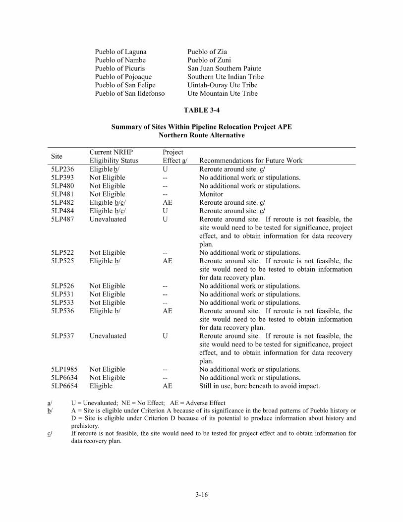
Based on a previous Class III survey that was conducted in 1980 in the Ridges Basin area, 20 cultural resource sites were identified within approximately 100 feet of the edge of the relocation corridor. Seventeen of these sites were identified as being located within the APE and potentially affected by construction of the pipeline relocation project (see table 3-4). Of these seventeen sites located with the APE, four remain unevaluated and four are recommended as eligible for the National Register for Historic Places (NRHP). The remaining nine sites are not eligible for listing on the NRHP. No further work or stipulations are recommended for these sites. Additional investigations of the eight sites marked as �eligible� or �unevaluated� on table 3-4 would be carried out as part of an overall cultural resources mitigation program for the entire ALP Project, which would be administered by the Ute Mountain Ute Indian Tribe. Attachment H to the FSEIS (Volume 2) contained a Final Amended Programmatic Agreement and Native American Graves Protection and Repatriation Act (NAGPRA) Plan which set forth the procedures to be adhered to in order to ensure compliance with all historic preservation laws. Section D of the PA described the actions to be taken to minimize effects to identified historic properties as a result of constructing and operating the ALP Project. These same steps would be followed to avoid any adverse effects to cultural resources sites within the Ridges Basin Pipeline Relocation corridor. 3.3.1.2 Southern Route Previous inventories conducted within Ridges Basin have not identified a significant number of cultural resources along the southern route. Attachment K of the FSEIS discussed two route options (�N� and �O�) that are very similar to the southern route. Appendix A (see page A-1) of Attachment K concludes that cultural resource surveys were 90 percent complete for these option �N� and minimal impacts would occur. For option �O�, moderate impacts could potentially occur. Based on this previous analysis, and because much of the pipeline relocation corridor would be located on the very steep terrain of Basin Mountain, additional cultural resource surveys were not conducted for the southern route alternative. In fact, only two previously recorded sites (5LP181 and 5LP617) fall within 250 feet of the centerline for this alternative. The southern route would likely easily avoid these resources. The 0.3-mile that falls on Southern Ute Indian Tribe land, however, would need to be inventoried to assure avoidance of any sites on that parcel. 3.3.1.3 Native American Consultation The FSEIS (see pages 3-143 and 6-12) describes the consultation activities that were initiated with Native American groups that are interested in the Ridges Basin area, including the area that would be affected by relocation of the Northwest and MAPCO pipelines within Ridges Basin. The 26 tribes listed below were identified to have ancestral or contemporary ties to the Ridges Basin project area:
Hopi Tribe Pueblo of San Juan Jicarilla Apache Nation Pueblo of Sandia Navajo Nation Pueblo of Santa Ana
Pueblo of Acoma Pueblo of Santa Clara Pueblo of Cochiti Pueblo of Santo Domingo Pueblo of Isleta Pueblo of Taos Pueblo of Jemez Pueblo of Tesuque
3-16
Pueblo of Laguna Pueblo of Zia Pueblo of Nambe Pueblo of Zuni Pueblo of Picuris San Juan Southern Paiute Pueblo of Pojoaque Southern Ute Indian Tribe Pueblo of San Felipe Uintah-Ouray Ute Tribe Pueblo of San Ildefonso Ute Mountain Ute Tribe
TABLE 3-4
Summary of Sites Within Pipeline Relocation Project APE
Northern Route Alternative
Site Current NRHP Eligibility Status
Project Effect a/
Recommendations for Future Work
5LP236 Eligible b/ U Reroute around site. c/ 5LP393 Not Eligible -- No additional work or stipulations. 5LP480 Not Eligible -- No additional work or stipulations. 5LP481 Not Eligible -- Monitor 5LP482 Eligible b/c/ AE Reroute around site. c/ 5LP484 Eligible b/c/ U Reroute around site. c/ 5LP487 Unevaluated U Reroute around site. If reroute is not feasible, the
site would need to be tested for significance, project effect, and to obtain information for data recovery plan.
5LP522 Not Eligible -- No additional work or stipulations. 5LP525 Eligible b/ AE Reroute around site. If reroute is not feasible, the
site would need to be tested to obtain information for data recovery plan.
5LP526 Not Eligible -- No additional work or stipulations. 5LP531 Not Eligible -- No additional work or stipulations. 5LP533 Not Eligible -- No additional work or stipulations. 5LP536 Eligible b/ AE Reroute around site. If reroute is not feasible, the
site would need to be tested to obtain information for data recovery plan.
5LP537 Unevaluated U Reroute around site. If reroute is not feasible, the site would need to be tested for significance, project effect, and to obtain information for data recovery plan.
5LP1985 Not Eligible -- No additional work or stipulations. 5LP6634 Not Eligible -- No additional work or stipulations. 5LP6654 Eligible AE Still in use, bore beneath to avoid impact.
a/ U = Unevaluated; NE = No Effect; AE = Adverse Effect b/ A = Site is eligible under Criterion A because of its significance in the broad patterns of Pueblo history or
D = Site is eligible under Criterion D because of its potential to produce information about history and prehistory.
c/ If reroute is not feasible, the site would need to be tested for project effect and to obtain information for data recovery plan.

3-17
In preparing this EA, Reclamation, assisted by consulting anthropologists, contacted the Pueblo of Jemez concerning a traditional cultural property in the vicinity of Carbon Mountain (SWCA 2002). The consultation letter provided a description of the pipeline relocation project and included maps showing the project location. It also included a request for any concerns that the group may have regarding the effects the project may have on sites of traditional religious or cultural importance. A response from tribal officials stated that they believed that the site would not be impacted by the proposed pipeline relocation project. A letter of comment on the Draft EA as well as the NHPA and NAGPRA records for the project was received from the Pueblo of Laguna. They requested to be involved in any conferences that might be held on the NAGPRA Plan, and to be notified when pipeline construction begins. Their letter is included in Attachment C as comment letter #11. 3.3.2 Land Use The land uses in the project area are described in section 3.113 of the FSEIS (see page 3-215 et seq.). Additional information on the relationship of the pipelines routes to specific land uses in the project area is provided below. No new significant land use impacts as a result of constructing and operating the proposed pipeline relocation project are anticipated beyond those originally discussed in the FSEIS (see page 3-223). Once the pipelines are operational, future land uses would be expected to continue except as modified by future recreational facilities that may be constructed by entities other than Reclamation. 3.3.2.1 Northern Route The northern route is located within La Plata County and is approximately 6.9 miles in length. The route begins at a point on the existing pipeline right-of-way located in Section 7 Township 34 North Range 9 West, La Plata County, Colorado. Most of the northern route is located on property owned by Reclamation. The exceptions are as follows:
• Between MPs 0.3 and 1.9, approximately 8,690 feet of the northern route alternative is located on property owned by the CDOW and La Plata County. Reclamation would acquire easements to cross the CDOW lands.
• Between MPs 2.8 and 4.2, approximately 7,800 feet of the northern route alternative is
located on property owned by the CDOW. The entire northern route would cross open and undeveloped land. Access to the pipeline relocation corridor in the Ridges Basin area would be via CR 211, currently an improved, two-lane gravel road There is also a private road across Reclamation property within Ridges Basin, which would provide access to the east tie-in point at MP 0.0. From MP 0.0 to the top of Carbon Mountain, access would be from an existing jeep road used for vehicle access up the mountain. On the north side of Carbon Mountain, access would be provided from existing CR 211, which crosses the northern route at MP 2.3. From MP 3.5, the route would parallel an existing private road on CDOW property, which provides vehicular traffic access to approximately MP 6.0. The west tie-in location would be accessed from CR 141 and CR 211. No residences are located within 50 feet of the existing and construction rights-of-way, construction access roads, or staging/laydown areas. The nearest residences are located in the rural residential development located southwest of the Rafter J access off CR 141 (Wildcat Canyon Road). The pipeline alignment would cross within 300 feet of one residence located in this area.

3-18
The UMTRA disposal cell is located approximately 750 feet east of the northern route. The alignment routes the pipeline up slope of the Bodo Industrial Park and immediately down slope of the UMTRA disposal cell site. The disposal cell contains radioactive tailings and contaminated alluvial deposits removed, under DOE supervision, from the Durango UMTRA site. The required permanent right-of-way for the northern route is estimated to be approximately 150 feet in width for placement of all three pipelines; however, in certain locations the construction right-of-way could be up to 40 feet additional in width on one or both sides of the right-of-way. Following construction, the permanent 150-foot right-of-way would be maintained as an operational right-of-way. This right-of-way would be maintained in a general grassy condition and current land use would be allowed to continue. However, the reestablishment of large trees within the operational right-of-way would be prevented so as to not interfere with the operation of the pipeline. Residences located near the west tie-in point for the northern route would be subject to temporary noise and dust impacts. Dust and noise control measures would be implemented as necessary during construction to avoid or minimize these impacts. Construction and operation of the pipeline would not displace any residences or businesses, nor would it have a significant adverse impact to any land use elements important for community character. The project would not conflict with adopted zoning or proposed or approved development plans. For those portions of the northern pipeline alignment to be constructed on property owned by the CDOW, there is the potential for construction activities to disturb recreational land use activities within BWA and could reduce the rural quality of the surrounding area. These impacts are expected to be temporary in nature, as the construction right-of-way would be allowed to return to a general grassy condition as discussed above. 3.3.2.2 Southern Route The southern route is approximately 4.3 miles in length. The route begins at a point along the existing pipeline right-of-way located in Section 7 Township 34 North Range 9 West, La Plata County, Colorado. The lands crossed by the southern route alternative include private ownership held by the Gunnison Cattle Company (Trappers Crossing), Donald and Diane E., Harper, and Lawrence E. Harper. The remainder of the alignment is located entirely within lands owned by Reclamation with the exception of a small portion of the alignment that is located on Southern Ute Indian tribal lands. Most of the route is located on the steep north-facing slopes of Basin Mountain. The tie-in location with the existing pipeline is located at MP 4.2 in Ridges Basin. Access to the southern route alternative is very limited, with only two access points located along the alignment. The existing private road on Reclamation property described above for the northern route would also provide access to the east-tie in for the southern route. From this beginning point at MP 0.0, there is no available existing road access to the construction right-of-way area until MP 4.2, which is located adjacent to existing CR 211. No residences are located within 50 feet of the existing and pipeline relocation corridor or staging/laydown areas. The nearest residences are located in the Trappers Crossing residential development, which lies south of existing CR 211 in Ridges Basin. There are approximately seven existing homes in this development. The western tie-in point of the southern route pipeline alignment is located approximately 2,250 feet from the eastern edge of the Trappers Crossing development. The construction right-of-way for the southern route involves extensive extra work space due to the steep slopes that would be encountered along Basin Mountain. It is estimated that a right-of-way of 225 to 275 feet may be required for construction of the three pipelines in certain areas along the southern route.

3-19
If conventional construction operations were utilized, extensive blasting and grading of the mountain would be required, creating a massive construction scar down the face of Basin Mountain. Residences located in the Trappers Crossing development would likely be exposed to noise and dust impacts during construction of the very western portion of the southern route. It is likely that residences in this general area would be also be affected by the blasting noise associated with construction of the eastern portions of the alignment that lie along the steep slopes of Basin Mountain. 3.3.3 Transportation The transportation resources in the project area are described in Section 3.15.3 of the FSEIS (see page 3-236 et seq.). Additional information on the relationship of the proposed pipelines to transportation resources in the vicinity of the pipeline routes is provided below. No new significant transportation impacts are projected from the pipeline construction now proposed. 3.3.3.1 Northern Route The northern route alternative is in close proximity to three local County roads: CR 211, 212, and CR 141 (see (Figure 1-2). The route would cross the existing CR 211 (currently a two-lane gravel paved road) near the UMTRA disposal cell site. The route would then cross CR 212. CR 212 is a two-lane gravel road in fair to good condition. The alignment would also be located immediately south of CR 141 in the vicinity of Wildcat Canyon.
3.3.3.2 Southern Route Unlike the northern route, which has access from several improved roads, access to the southern route is very limited. Only two road accesses are available. One access is an existing private road on Reclamation property that would provide access to the east tie-in for both the northern and southern route alternatives. From M.P. 0.0 there is no available existing access road until the alignment crosses CR 211. The only construction access would be along the right-of-way. 3.3.4 Visual Resources The visual resources associated with the Ridges Basin area are described in section 3.2.3 of the FSEIS (see page 3-280 et seq.). Additional information on the relationship of the pipeline relocation project as it relates to visual resources is described below. This section also describes the potential impacts to visual resources that could occur from construction and/or operation of the pipeline relocation project.

3-20
3.3.4.1 Northern Route As described in section 3.2.3 of this EA, the existing lands along the northern route are comprised of pinyon-juniper woodland, semi-arid grasslands, and ponderosa pine forest. Carbon Mountain is the dominant feature of the area with its steep face and strong contrast of color, texture, and form (see FSEIS page 3-281). The terrain near MP 0.0 at Basin Creek steeply increases in elevation as the route traverses the east side of Carbon Mountain. Views of this route from the Animas River or from CR 212 are not visible primary because of the terrain. The route is also not visible from Ridges Basin since Carbon Mountain dominates the foreground views. As the alignment crosses the backside of Carbon Mountain ridgeline, the alignment traverses a steep slope down toward the existing CR 211, near the existing electric substation and UMTRA disposal cell site. From this point, the alignment crosses CR 211 and follows an existing non-paved access road west of the UMTRA disposal cell site and enters a stand of pinyon-juniper and ponderosa pine forest. The alignment continues west, southwest and portions of the alignment are visible from Wildcat Creek and CR 141 (Wildcat Canyon Road). The alignment remains south of Wildcat Creek and terminates within the existing rural residential area south west of Rafter J access. CR 211 begins near the west tie-in of the northern route, at the intersection of CR 141 and continues east through Ridges Basin, passing near the Trappers Crossing residential development, and then northeast toward Durango. Views from CR 211 within the Ridges Basin area are, for the most part unobstructed, and include Carbon Mountain, Basin Mountain and the slightly higher elevation areas surrounding Ridges Basin. CR 141 extends through Wildcat Canyon and intersects on the western end of the project area with CR 211. County Road 141 is a paved two-lane road and within the project area passes within semi-arid grassland, pinyon-juniper and ponderosa pine forest. The view shed of this section of CR 141 is more limited than that of CR 211 because of its location within Wildcat Canyon. CR 141 follows portions of Wildcat Creek and views of Basin Mountain and Carbon Mountain are visible. The lands within Ridges Basin are not visible from CR 141. Construction of the northern route would result in significant visual impacts during the construction period. The construction right-of-way would be visible from CR 141 along Wildcat Creek. Construction would also be visible from the western end of CR 211 and along the existing access road near the UMTRA disposal site. Generally, these construction impacts would be temporary in nature; however, prior to revegetation and during revegetation, which may take years (3 to 5 years at a minimum) for vegetation to reestablish, evidence of the construction right-of-way would be visible from CR 141. Recreation users within the Wildcat Canyon area would have closer and more extensive views of the right-of-way but as vegetation establishes the extent of the visual impacts would diminish over time. However, since the permanent right-of-way would be maintained with low growing vegetation, and the establishment of large woody vegetation would be prohibited to protect the integrity of the pipeline, the visual scar would remain. Following establishment of vegetation, the visual impacts of the northern route alternative would be minimal and would be similar to the physical characteristics of the existing gas pipeline alignments. From Ridges Basin, the right-of-way would not be highly visible because of the location of the route across gently sloping hills sides immediately north of the Basin area.
The 2000 FSEIS outlined several measures to be implemented by Reclamation to help reduce impacts associated with the construction and presence of the physical components of the ALP Project. As indicated on page 3-283 and page 5-20 of the FSEIS, Reclamation would employ the services of a

3-21
qualified landscape architect to develop and supervise implementation of a landscaping plan that specifically focuses on minimizing the visual impacts of the pipeline relocation project. Other specific Measures specific to pipeline construction include:
• Areas graded and trenched along the right-of-way would be restored to original grades, to the extent practicable. In doing so, the terrain would appear similar to pre-project conditions when viewed from a distance. Waste rock would be blended into the slopes and edges of the corridor or scattered along the right-of-way to help provide a more natural view.
• A directional drilling construction technique would be used to bore through Carbon
Mountain, thereby reducing the potential for visual scarring to occur on Carbon Mountain as a result of the new pipeline alignment.
• To minimize the visual impact of the right-of-way on the slopes of Carbon Mountain, the
above-described measures would also be required in addition to contouring of the slopes following backfilling of the pipeline trench to blend the corridor into the existing terrain.
• A visual mitigation plan would be developed for the corridor and would include measures
to reduce the long-term visual impact of the right-of-way, especially on the slopes of Carbon Mountain. Measures should include planting on all slopes of less than 79 percent, use of specialized vegetation plantings to screen portions of the right-of-way from key observation points such as CR 211.
3.3.4.2 Southern Route Views from the southern route are expansive because of the location of the alignment along the slopes and ridgeline of Basin Mountain. From Basin Mountain, expansive views of the lands north, east, south, and west are visible including a broad view of Wildcat Canyon, Carbon Mountain, and Ridges Basin. From CR 211, and to a lesser extent sections of CR 141, long sections of the southern route alternative are visible. Nearly the entire alignment is visible from CR 211 and from Ridges Basin. Within the Trappers Crossing and other residential areas near CR 141, the southern route would be visible from existing homes.
Construction of the southern route alternative would result in temporary and permanent significant visual impacts. The southern route traverses the north slope Basin Mountain and climbs to the ridgeline at a nearly 7200-foot elevation before dropping down to the eastern tie-in at Basin Creek. During construction, the construction right-of-way would be visible from numerous view sheds including CR 141, CR 211, and CR 212, Ridges Basin, and the residential areas near Ridges Basin. The width of the right-of-way would need to be wider than the northern route because of the steep terrain; thus, the visual scarring would be more visible than the northern route. Equipment movement and a linear scarring would be highly visible from lower elevations. This would temporarily diminish the rural aesthetics and visual quality of the mountainous terrain. Following construction the linear scarring would remain highly visible until vegetation is allowed to reestablish. As discussed for the northern route alternative, the visual impacts would remain since the area would be maintained in low growing vegetation and not be allowed to establish to pre-existing conditions. The same measures outlined for the northern route would be implemented to help reduce impacts associated with the construction and presence of the project.

3-22
3.3.5 Recreation Recreational resources within the pipeline relocation project area were described as part of the overall evaluation of Ridges Basin recreational resources in the FSEIS (see section 3.11.3.2, page 3-182). Given the proximity of the pipeline relocation project to Ridges Basin Dam and Reservoir, this EA evaluates the potential impacts the project could have upon existing and anticipated recreational resources within the Ridges Basin area. 3.3.5.1 Northern Route As noted in the FSEIS (see page 3-182), recreation use in the Ridges Basin area consists mainly of hunting and nature observation. Wildlife in the area includes mule deer, elk, and golden eagles. There are no official hiking or horseback trails in or up to Ridges Basin. However, some incidental hiking and horseback riding occurs. Cross-country skiing and snowshoeing also occurs in the winter months when conditions allow. The portion of Wildcat Creek near the pipeline relocation alignment is used for similar types of recreation. During a field review for this project, some evidence of cross-country skiing was observed, and the portion of CR 211 near the UMTRA disposal site was being heavily used by walkers for day hikes. In addition, cycling occurs on CR 212 and CR 211 near the UMTRA disposal cell site. The 2000 FSEIS (see page 2-110 et seq.) described future recreational facilities that could be constructed north of Ridges Basin Reservoir by a non-federal entity. Two areas near Wildcat Creek (near Rafter J access) were identified as potential recreation areas. These facilities, as envisioned, would be designed to be compatible with fish and wildlife plans for the Ridges Basin area and would likely include campground facilities and hiking trails. The northern route would be constructed in lands identified as potential recreation areas. Pipeline construction could impact these existing and future recreation facilities. During construction, access to existing areas used for hiking and hunting may be prohibited or severely limited. In particular, the existing access road near Wildcat Creek and the areas within Ridges Basin used for construction laydown would likely be affected as a result of the presence of construction equipment, construction noise, and disturbance to wildlife. Equipment movement may present a safety hazard to hikers and hunters. In addition, depending on the timing of construction, hunting within areas along the alignment may be prohibited for safety concern for both construction workers and hunters. It is anticipated that the types of existing recreational use north of Ridges Basin would be affected during the length of time it takes to complete the proposed project. Following construction, operation of the northern route alternative may also affect existing recreational uses in the area. The introduction of a gas pipeline right-of-way through an area that is currently used for recreation could diminish the recreational value of the lands immediately north of Ridges Basin for hiking, snowshoeing, cross-country skiing, hunting, nature watching and sightseeing. The presence of the gas pipeline through the area also is not expected to create any potential safety issues for future recreation facilities. Since no concentrated or organized recreational areas would be crossed by the pipeline alignment, the greatest impact on recreation (as described above) would be construction�related disturbances. Recreational facilities were addressed in the ALP FSEIS (Reclamation 2000a) and no further details of their size and location are available at this time. However, whenever and wherever they are constructed, the developers of these future recreational facilities would work with Reclamation to ensure that compatible uses of the right-of-way occur.

3-23
3.3.5.2 Southern Route Existing recreation along the lands crossed by the southern route alternative are limited to hunting and sight seeing because of the steep terrain along the ridge of Basin Mountain. No recreational facilities would be affected by construction or operation of the southern route. 3.3.6 Socioeconomics Section 3.12 of the FSEIS (see page 3-198 et seq.) addressed the existing socioeconomic setting and potential impacts to socioeconomic resources associated with the entire ALP Project area, including those portions of La Plata County that could be affected by the relocation of the pipelines, road, and transmission line. No significant new or residual socioeconomic impacts are projected as a result of constructing or operating the pipeline relocation project.