
Chapter 21 River Mechanics
44
Chapter 21 River mechanics NOTE: This is a compilation of my early publications on river behaviour. The material has become increasingly important in the light of rising interest in riverine ecology as described in the immediately following chapters.
description
Ingeniería de ríos
Transcript of Chapter 21 River Mechanics
Chapter 21
River mechanicsNOTE: This is a compilation of my early publications on river behaviour. The materialhas become increasingly important in the light of rising interest in riverine ecology asdescribed in the immediately following chapters.
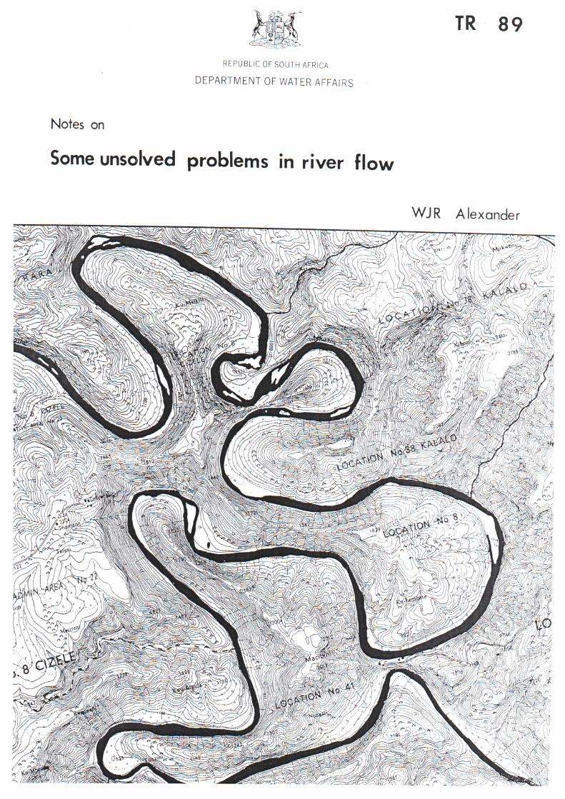
REPUBLIC OF SOUTH AFRICA
DEPARTMENT OF WATER AFFAIRS
TR 89
Notes on
Some unsolved problems in river flow
WJR Alexander

—
DEPARTMENT OF ENVIRONMENT AFFAIRSBrajvch of Scientific Services
Technical Note 70
W INTRODUCTION TO
RIVER MECHANICS AND CHANNEL STAB1USAT10N
byW J R Alexander
September, 1971
Revised March, 1976
Second rey^sian, May, 1962

(i)
INDEX
Page
1. RIVERS IN ALLUVIUM 1
2. HYDRAULICS OF ALLUVIAL CHANNELS 5
Principal hydraulic properties 5
Three dimensional flow patterns 6
3. SEDIMENTATION 7
Wash load 7Bed load 8Sediment properties 8
Sediment motion 9
Suspended load 10
4. BED FORMS 11
Changing forms 11Ripples 13Dunes 13
Plane bed 14Anti-dunes 14
Chutes and pools 14
Bars 15
Regimes of flow 15
5. AGGRADATION AND DEGRADATION 18
6. RIVER MORPHOLOGY 20
Formative discharge 20
Equilibrium conditions 20
Sinuosity 21Properties of meanders 21

(11)
Meander belt migration 21
Effect of flow magnitude 22River channel classification 23Long term changes 23
7. THE FLOOD PLAIN 26
8. VULNERABILITY TO DEPOSITION OF SEDIMENT 27
Submergence by standing water 27Deposits on river banks 27Deposits in stable sections 28
Deposits in unstable sections 28Summary 28
9. VULNERABILITY TO EROSION 29
Bank erosion 29Chute erosion 31Summary 31
10. HYDROLOGY 32
11. PRINCIPLES OF CHANNEL STABILISATION 35Channel shape 35Channel slope and sinuosity 36Channel contraction 37
Channel alignment 37
12. REFERENCES 39
13. APPENDIX
Notes on the suggested use of steel jetty fields
14 - 1
1. RIVERS IN ALLUVIUM
An understanding of the processes at work in the flood plain of a riverflowing through sediments that it has deposited over a long period oftime is necessary for a full appreciation of its vulnerability to flooddamage and the problems associated with possible protective measures.
The dominant variables affecting the course of a river flowing throughalluvial deposits are those associated with the magnitude and frequencyof river flow, and their interrelationship with the erosion, transportationand deposition of sediments within the river channel. The interactionsof these variables are highly complex. Consider the following twoexamples :-
(a) The simplest river hydraulics problem is that of a fully canalisedriver flowing down a channel of known shape, slope and roughness.The variables involved are :-
*Width and depth of flow, dross-sectional area and hydraulic radius :These are al l determinable constants for a given f low.
Energy slope : This is sensibly equal to the bed slope which is
a known constant.
Channel roughness : A known constant.
Sediment load : Provided the channel is steep enough, thesediment entering the channel will be transported through itwithout affecting the flow characteristics.
Formulae : Several formulae provide unique solutions for therelationships between the above variables.
1 4 - 2
(b) Compare this with a river flowing down an alluvial valley :-
Width and depth of flow, cross-sectional area, and hydraulic radius :
All of these will vary along the length of the river. They will
also vary with the flow at any one point in the river. Theirmagnitude and the relationships between them cannot readily be
computed for a given flow.
Energy slope : This a function of the length of the river which
is a function of its sinuosity which in turn is an unknown variable.
Channel roughness : This is a function of the grain size of the
material comprising the channel perimeter and its form i.e. the
size and shape of dunes, bars etc in the river bed. There is a
complex inter-relationship between these and the velocity andturbulence of the water/sediment mixture of the flowing river.
Sediment load : The river channel will adjust itself to the
sediment load reaching it from upstream as well as the characteristics
of the material through which it flows.
Formulae : No formulae are presently available which describethe inter-relationship between these variables.
Figure 1 illustrates the problem.
Given an idealised valley with readily erodable material, there would seem
to be no limit to the number of different paths that the river could take
from point X "to the ocean. However, the observation of existing rivers
has shown that there is a relationship between a river's sinuosity and
its other characteristics. The dominant formative factors are the
magnitude of flow and the available potential energy (height differencebetween point X and mean sea level). The actual valley slope is of less
significance.

14 - 3
FIGURE 1
CONTROLS
Geology
Elevation
DRIVING VARIABLES
Water : flow rate
flow variability
Sediment •• load
size distribution
RESPONSE VARIABLES
Channel : width
depth
slope
Meander: wave length
amplitude
FACTORS WHICH DETERMINE RIVER CHANNEL CHARACTERISTICS
uOuu
Scour and transport
clay silt sand gravel
PARTICLE DIAMETER (mm)
FIGURE 2 : APPROXIMATE RELATIONSHIP BETWEEN WATER VELOCITY AND THE TRANSPORT
AND DEPOSITION OF SEDIMENT.
14 - 4
In order to achieve uniform energy loss per unit distance along thechannel, the river will develop a typical meander pattern predictablein its sinuosity, but random in direction and therefore position.Seen in plan view, the processes at work are those which tend toeliminate concentrations of energy loss.
Seen in profile, the same tendencies operate in the erosion-depositionmechanism both in the river system as a whole and in given segments ofit. This results in a concave upwards profile of the river, withincreasing steepness towards the headwaters due to the lesser volumes offlow in the river and the coarser sediment particles. Whereverabnormalities occur in the profile (rapids or slopes flatter than normal)the energy distribution will tend to restore the balance by acceleratingerosion at the rapids or by the deposition of sediment at the upstreamend of the flatter reaches.
It is interesting to note that meandering streams have been observed insuch highly homogeneous mediums as ocean currents and water channels onthe surface of glaciers, where the role of boundary conditions orirregularities in the material through which the streams flow are minimal.
A straight river does not exist in nature. Even straight reaches of ariver very seldom have lengths exceeding ten times the channel width.Most of the rivers in South Africa are actively degrading i.e. incisingtheir channels in the bedrock over which they flow, and the courses oftheir channels are largely determined by the geological properties ofthe bedrock. However, when these rivers enter alluvial valleys the samegeological constraints are not present, and the dominant factors affectingthe course of a river are those associated with the erosion, transportand deposition of the sediment through which the river flows. Thecombined effect of these variables is highly complex, and river mechanics,even after years of intensive investigation, is still not an exact science,
14 - 5
2. HYDRAULICS OF ALLUVIAL CHANNELS
The mechanics of flow in alluvial channels, and the response of thechannel geometry to these flows are not as well understood as manyother phases of hydraulics. For example, the velocity of a streamflowing through alluvium will react not only to changes in the bed slopeand depth, but also to the shape of the cross section; the form of bed
roughness; the positions and shapes of major sediment deposits withinthe channel; the magnitude of sediment load; and many other variables.Unlike rigid boundary hydraulic problems, it has not been possible toisolate and define the roles of single factors. Nor has it been
possible to treat the hydraulic properties of an alluvial river inisolation from those of sediment transport. In the past both have beencombined to provide the "Regime Theory" concept which was largely
empirical. Only recently have the sounder, but more complex theoreticalapproaches been applied to the problem.
Principal hydraulic properties
The principal properties of flow which have to be considered in rivermechanics problems are :-
Variation of flow with time : Does the velocity (speed and direction)at a fixed point vary with time (unsteady flow) or not (steady flow) ?
Variation of flow with distance : Is the flow uniform (is the velocitythe same at all points having the same relative position along the stream)?If not, is it gradually varied flow or rapidly varied flow ?
Variation in stability : Is the flow laminar or turbulent ? Is the
surface flow stable or unstable (roll waves present) ?
Variation in roughness : What material constitutes the bed and banksof the channel and what form does it take (ripples, dunes, bars etc) ?
What are the velocity and shear stress distributions within the waterbody ?

14 - 6
Some other points that should be noted are :-
Energy gradient : The energy gradient, rather than the water surface
or bed slopes, should be used to obviate local effects of non-uniformity
in flow conditions.
Friction factor : This depends upon the relative roughness i.e. thesize of the controlling roughness element in relation to the hydraulicradius. In some cases this will be the individual grain size wherethe diameter is measured in fractions of a millimeter, and in othersit may be bed dunes having dimensions measured in meters
Velocity measurements : At high stages, mean velocities may be of theorder of 3 to 4 metres per second. Maximum point velocities may be upto 50% greater than this. The turbulent fluctuating component of themean average velocity may have a standard deviation of the order of 30 -40% of the mean with maxima of three times this value.
*Three dimensional flow patterns : Velocity is a vector and therefore
both magnitude and direction have to be defined. Secondary currentswhich arise from the complex geometry of alluvial rivers play asignificant role in the erosion and deposition processes, but theanalysis of three dimensional flow is very complex. Secondary currents
in a prototype may not be reflected in model studies, and care must beexercised in their interpretation.
14 - 7
3. SEDIMENTATION
The erosion, transportation and deposition of sediment is largely afunction of the velocity and turbulence of the flowing water, and thesize, shape and cohesiveness of the particles of sediment.
The tractive force is the force exerted by the water on the channelboundary. It is therefore equal and opposite to the resistance offlow that the boundary exerts on the water and is thus proportional to
the square of the velocity. The quantity of material that can betransported by water is proportional to the 2nd to 3rd power of thetractive force and thus to the 4th to 6th power of the stream velocity.The transport capacity of flowing water is therefore highly sensitive
to changes in velocity.
While the velocity at which particles of sediment begin to fall out ofsuspension is principally a function of grain size, the velocity at whichscouring commences is a function of both grain size and cohesiveness.Thus fine sand is far more prone to erosion than either the silt or
gravel fractions. (See Figure 2).
When considering the movement of sediment in streams, a differentiationhas to be made between bed load and wash load.
Wash load
Wash load is material which, although it occurs in quantity in the stream,
is not found in significant quantities in the stream bed. The capacityof the stream to transport wash load therefore exceeds the rate of supplyfrom the catchment. The wash load has no significance in determiningthe stability of the channel. Turbulence is the principal factor inmaintaining the wash load in suspension.
14 - 8
Bed load
Bed load on the other hand has been, or is being furnished by thecatchment at a rate which equals or exceeds the capacity of the streamto transport it. Whether in fact it remains on the bed, or istransported along or deposited on it, is dependent on the velocity ofthe water at that point and the consequent traction force on the streambed. The type of material in the stream bed therefore largelydetermines the characteristics of the river channel and adjacent flood
plain.
Sediment properties
The primary factor in the interaction of the sediment in the bed, banks,or suspended in the water/sediment mixture, and the flowing mixture
itself, is the fall velocity of the sediment particles. When measuringthis property the interaction between the particles themselves, theproperties of the water and solids mixture, as well as its turbulencehave to be taken into account.
The effect of the properties of the particles of a sediment on theirsusceptibility to transportation are as follows :-
Property Selective transport
Size largeShape (sphericity) largeOrientation largeDensity mediumRoundness (corners) negligibleSurface texture negligible
The bulk properties of a sediment are as important as those of its
individual components. A homogeneous mixture of sediment consistingof particles having a wide range of sizes, shapes, densities and textures
1 4 - 9
exposed to f l o w i n g water, w i l l not remain homogeneous for long.
S m a l l , f la t particles lying on the surface of the sediment w i l l be thefirst to be removed by the water. After the smaller surface particleshave been removed, the increasing number of large, more nearlyspherical and dense particles which become exposed, w i l l provide anarmouring which w i l l protect smaller particles beneath them fromsubsequent erosion. If the probabil i ty that the larger grains w i l lnot be moved is h igh enough, only a certain amount of degradation isnecessary to expose enough coarse material in the top layer to stabilisethe bed. The susceptibility of a sediment mixture to erosion is thereforea funct ion of the proportion and properties of its larger fractions ratherthan those of the smaller fractions or the mixture as a whole.
The problem of describing such a mixture then arises. It is usua l lyaccepted that the number of grains of various diameters in naturalsediments is log-normally distributed. The mean diameter and thestandard deviation w i l l then completely identify the mixture.
)
Sediment motion
The sixth-power-law first postulated in 1753 which states that thetransportation capacity of f lowing water is proportional to the sixthpower of its velocity, is s t i l l accepted as a first approximation today.Whether or not an ind iv idua l gra in in a mixture w i l l be moved or not canbe evaluated by consideration of "average behaviour" or by "probabil ist icbehaviour". Equations for both of these assumptions exist, but thelatter is more realistic.
Material being moved along a river bed is not in continuous motion.The finer material may be carried along in long, frequent hops (saltation)and the larger material in short, less frequent ro l l ing along the bed.When dunes are formed in the bed, particles w i l l be alternatively exposedon the upstream surface or a dune, transported to the downstream surface,buried by successive layers of particles, and exposed once more as thedune migrates downstream.
14 - 10
Suspended load
The usual assumption that the suspended sediment load (wash load) isproportional to the flow is not strictly correct. The wash load isaffected by such factors as the intensity of the precipitation,vegetal cover, season of the year, properties of the surface soil,topography, size of the stream, stability of the channel, shape ofthe basin and dams in the catchment. While the wash load usuallyincreases with an increase in flow, the peak may not coincide withthat of flow.

14 - 11
4. BED FORMS
The channel perimeter of an alluvial river is not a regular, solidboundary, but consists of moving and changing forms that varycontinuously in size and shape, in both time and space.
The changes in bed form which result from the interaction of the flowand the bed material are a function of the characteristics of the flow,the properties of the water/sediment mixture, and the properties of thebed material. Thus the resistance to flow and sediment transport arefunctions of the slope and depth of the stream, the viscosity of thefluid mixture, and the size distribution of the bed material. Theviscosity of the fluid mixture is a function of its temperature and theconcentration of the sediment in suspension. The interaction betweenthe flow and the bed material and interdependence among the manyvariables makes the analysis of flow in alluvial rivers extremely complex,However, an understanding of the different types of bed forms that mayoccur; of the resistance to flow and sediment transport associated witheach bed form; and of how the variables of depth, slope, viscosity, etcaffect bed form, will greatly assist in the anticipation, eliminationor alleviation of problems that occur in alluvial rivers.
Changing forms
As the flow in the river decreases, the bed configuration will be thatformed during the flow when motion of the bed load ceased. However,lateral erosion of this material may continue as stage decreases stillfurther and the stream meanders within the river bed.
As the flow increases above bed full conditions once more, the remnantsof the previous bed forms will be obliterated progressively and thedominant bed form related to the new flow conditions will be established.The bed configurations that may form in an alluvial channel withprogressive increase in flow are plane bed without sediment movement,ripples, ripples on dunes, dunes, plane bed with sediment movement, anti-dunes, and chutes and pools . (See Figure 3).
/ 16

14 -'12
RIPPLES
Froude number « 1/go"
Height 6 - 50 mmindependent of depth
Flow resistance highfunction of depthindependent of grain size
Bed load 0 - 0,01 %
DUNES
Froude number
Height
Flow resistance
Bed load
Mode
< I
up to 13m (Mississippi)amplitude = average water depth
highindependent of depthdependent on grain sizedependent on form roughness
0,01 - 0,12 ',
erosion upstream and depositionin lee of dune
PLANE BED STANDING WAVES
Froude number 0,3 - 0,3
Height largest grain size
Flow resistance lowindependent of depthdependent on grain size
Froude number
Height
> 1
up to 2mdependent on depth0,5 - 0,7 x surface wave
Bed load
Mode
0,14 - 0,4 %
continuous movement
Flow resistance low but > plane bed
Bed load
Mode
0,4 - 0,7
continuous movement
ANT!-DUNES CHUTES AND POOLS
Froude number
Height
Flow resistance
Bed load
Mode
up to 2mdependent on depthdependent on grain size
high due to breaking waves
0,6 - 1,5 %
erosion of downstreamface and deposition in frontof next dune
Froude number
Dimensions
Flow resistance
Bed load
» 1
much longer thanprevious cases
large
0,6 - 1,5 X
FIGURE 3 : HYDRAULIC AND SEDIMENT TRANSPORT
PROPERTIES OF BED FORMS.

14 - 13
These bed-roughness elements are not mutua l ly exclusive in time and
space. They may form side by side in a cross section or reach of ariver g iv ing m u l t i p l e roughness; or they may form in sequence in time,producing var iable roughness.
Ripples
Ripples will only form in bed material which has a median particle sizediameter less than 0,6 mm. They offer a relatively large resistance toflow but since they do not exceed about 30 mm in height the relativeroughness decreases as the depth of flow increases. The resistance toflow is independent of the grain size of the bed material.
Dunes
As the flow (and therefore tractive force) increases, a rate of bed-material transport, a magnitude of velocity, and a degree of turbulencewill be reached that causes sand dunes to form in the river bed. Dunesmay vary from about 0,6 m to several metres in length and have heights(amplitudes) equal to the depth of the river (dunes as much as 13 m highand more than a hundred metres long have been observed in the MississippiRiver). These dunes may form in any alluvial channel where generaltransport of the bed material takes place. The dunes will be randomlysituated in the channel and, because they are associated with sub-critical velocities, they will be out of phase with the gravity watersurface waves which accompany them.
The existence of strong circulation in the trough area of a dune bedcauses boils to appear on the water surface just downstream of the crestsof the sand waves. The separation and turbulence generated dissipatesconsiderable energy which increases the resistance to flow. Hence, incontrast with ripples, the amplitude of dunes can increase withincreasing depth, so that the relative roughness can remain essentiallyconstant or even increase with increasing depth of flow.
14 - 14
Plane bed with sediment movement
As flow continues to increase, the dunes will become obliterated and aplane bed will form. Dunes of fine sand will be washed out at lowervelocities than dunes of coarser sand. The resistance to flow forflow over a plane bed results from grain roughness, but because thegrains are in motion rolling, hopping and sliding along the bed, theresistance to flow is slightly less than that for flow over a staticplane bed.
Anti-dunes
Where the flow passes into the supercritical range, sand dunes of a
different character will form. These will appear as a series or train
of dunes which are in phase with, and strongly interact with, the gravity
water surface waves that accompany them. In natural rivers these may
be up to 2 m high and 3 to 12 metres long. Anti-dunes are less stable
in time and space than other bed forms. They form as a train of waves
that gradually build up from a plane bed and plane water surface. Theymay grow in height until they become unstable and their crests commence
breaking. These dissipate a considerable amount of energy and cause
the waves to subside. As the anti-dunes form and increase in height,they generally move in an upstream direction or occasionally they may
remain stationary or move downstream. The resistance to flow depends
on how often the anti-dunes form; the proportional area of the stream
bed that they occupy; and the violence and frequency of their breaking.
If they do not break, the resistance to flow is about the same as for
a plane bed. With anti-dune flow, the fact that the water and bed
surfaces are in phase is a positive indication that the flow issupercritical.
Chutes and pools
At very steep slopes, alluvial channels cannot maintain uniform energygradients and the channels consist of a series of chutes and pools.
14 - 15
In part icular , this may occur dur ing h igh over-bank flow where largebends in the river are short-circuited. This type of flow consistsof long chutes in wh ich the f low accelerates rapidly; a hydraul icjump at the end of the chute; and then a long pool in which the flowis sub-critical but accelerating. The chute-and-pool system generallymoves gradual ly in an upstream direction. The resistance to flow islarge and may frequently cause a decrease in the mean velocity of flowand therefore increase in stage.
Bars
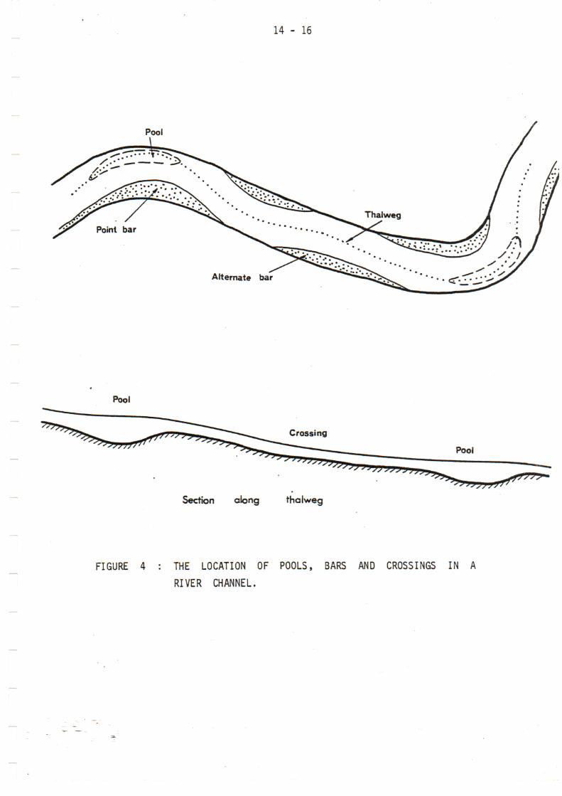
These are bed forms hav ing dimensions of the same order or greater thanthe channel wid th . U n l i k e the other bed forms listed above, they arerelatively static in posit ion, a l though the surface material may bemobile. (See Figure 4). Point bars occur on the inner banks ofbends with their centroids s l igh t ly downstream of the midpoin t of thebends. Alternate bars are distributed alternately on either side ofthe channel between bends and their size and position are functions ofthe meandering properties of the river. Their lateral extent iss ign i f ican t ly less than the channel width . Transverse bars occupynearly the f u l l channel width and are located at cross-over pointsbetween bends. Longitudinal bars (or middle bars) are formed bysecondary currents when the flow in the river is divided into two or moreparallel streams. These bars appear as is lands when the flow subsides.
Regimes of flow
To summarise, the f low in a l l u v i a l channels is divided into two mainflow regimes :-
Low flow regime (sub-critical velocity) :
1. Ripples .2. Dunes with ripples superposed.3. Dunes.
14 - 16
Pool
Alternate bar
Pool
Section along thalweg
Pool
FIGURE 4 : THE LOCATION OF POOLS, BARS AND CROSSINGS IN A
RIVER CHANNEL.
14 - 17
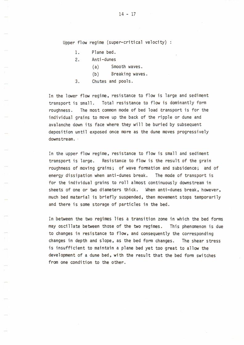
Upper flow regime (super-critical velocity) :
1. Plane bed.2. Anti-dunes
(a) Smooth waves.(b) Breaking waves.
3. Chutes and pools.
In the lower flow regime, resistance to flow is large and sedimenttransport is small. Total resistance to flow is dominantly formroughness. The most common mode of bed load transport is for theindividual grains to move up the back of the ripple or dune andavalanche down its face where they will be buried by subsequentdeposition until exposed once more as the dune moves progressivelydownstream.
In the upper flow regime, resistance to flow is small and sedimenttransport is large. Resistance to flow is the result of the grainroughness of moving grains; of wave formation and subsidence; and ofenergy dissipation when anti-dunes break. The mode of transport isfor the individual grains to roll almost continuously downstream insheets of one or two diameters thick. When anti-dunes break, however,much bed material is briefly suspended, then movement stops temporarilyand there is some storage of particles in the bed.
In between the two regimes lies a transition zone in which the bed formsmay oscillate between those of the two regimes. This phenomenon is dueto changes in resistance to flow, and consequently the correspondingchanges in depth and slope, as the bed form changes. The shear stressis insufficient to maintain a plane bed yet too great to allow thedevelopment of a dune bed, with the result that the bed form switchesfrom one condition to the other.
14 - 18
5. AGGRADATION AND DEGRADATION
The interaction of stream flow and the availability and properties ofthe bed material controls the stream geometry, and the location ofareas of erosion and deposition within the flood plain of a river.
Basically, if the sediment load delivered to a stream is greater thanthe stream can carry, then the excess will drop out of suspension andin so doing the stream will raise the elevation of its bed in theupper reaches. It will continue doing this until it establishes agradient at which its transport capacity equals the rate of supply.Conversely (and of special importance where dams are built in thecatchment), if the load delivered to the stream is less than itstransport capacity, material will be eroded from the channel until thegradient is such as to establish a new balance.
A river can change its energy gradient in different ways. It canincrease or decrease its length by changing its sinuosity withoutchanging the height difference between the terminal points.Alternatively the height difference could be changed over a constantlength by either erosion or deposition in the initial or terminal reaches,or by the establishment of a series of pools and drops. The energygradient can also be changed by variations in the width/depth ratioof the channel or by variations in its bed form (ripples, dunes, etc).
The interaction between the flow of the water/sediment mixture and thebed material moulds the bed into different configurations which change
resistance to flow and sediment transport. This in turn changes thedepth of flow, stage of the river, elevation of the bed, velocity of flow,etc. In the extreme case, the change in bed configuration can cause athree-fold change in resistance to flow and a 10- to 15-fold change inthe sediment transport capacity. Manning's n can change from 0,035 to0,012 in the same reach of the river. This three-fold increase couldresult in a two-fold difference in the depth of flow at two differentpoints in the river.

14 - 19
The whole problem is therefore one of dynamic equilibrium betweena number of interrelated factors. If one factor is varied,either naturally or deliberately, then one or more of the otherswill change until the stream is in equilibrium under the newconditions.

14 - 20
6. R I V E R MORPHOLOGY
Formative discharge
The shape and location of the river at a point in time is the resultof a long series of adjustments to changing conditions in the immediateand far distant past, with the river s tr iving to reach e q u i l i b r i u m aseach of the variables changes. The two dominant variables are therate of f low and the properties of the material in the river bed.The latter wi l l not show significant changes with time, whereas therate of flow can vary by 4 or 5 orders of magnitude in a matter of hours.Clearly, these adjustments wi l l be more radical and more severe as therange wi th in which the f low varies increases. Most of the damage causedwhen high floods occur in an a l luv ia l river can be traced to the river'sattempt to adjust itself to flow conditions vastly different from thosewhich formed the basic river channel.
Several investigators have attempted to relate channel geometry to"dominant discharge" or "formative discharge" which in turn are assumedto be the mean annual discharge, or the median annual discharge, or themean annual f lood. The Regime Theory has long perpetrated thismisconception. In my opinion there can never be a unique deterministicsolution to the relat ioship between f low and channel geometry. Thesolution wi l l have to be sought on a probabilistic basis which includesboth the magnitude and duration of flow as variables. The flow durationcurve could serve as a starting point for such an evaluation.
When considering channel geometry it must therefore be borne in mind thatthis is not static but oscillates about some mean condition. Thediscussions below relate to this mean condition.
\
Equilibrium conditions
Equilibrium conditions in an alluvial valley require an energy gradientflatter than that of the valley itself. For the most part this isachieved by the river increasing its sinuosity (ratio of channel length

14 - 21
to valley length) giving rise to the familiar meander pattern.Alternatively, where the river follows a straighter course it willtend to create a wide, shallow channel or series of channels (braidedstreams) although these are inherently less stable than meanders.
Sinuosity
Generally, the sinuosity will increase with decrease in valley slope;
with decrease in the dominant flow in the river; and with decrease inthe average grain size of the sediment. A material increase in bedload will produce large meanders and a wider and shallower channel.
Properties of meanders
Meanders have the following basic properties :-
(a) The thalweg (the line along the deepest part of the river) alwaystends to hug the outer bank of a bend whereas sediments aredeposited in the form of point bars on the inner bank.
(b) The depth of the pool along the outer bank, and the width of the
deposits on the inner bank, both increase with increase incurvature of the bend.
(c) The deepest point in the river channel and the greatest width
of the point bars are both somewhat downstream of the point ofgreatest curvature.
(d) Abrupt changes of direction cause instability of the channel.
(e) For equal meander length, the average depth is a function of the
angle between the entrance and exit tangents to the curve.
Meander belt migration
Bends and meanders are formed by the dual processes of erosion of theouter bank and deposition along the inner bank of the river. The
14 - 22
finer wash load material eroded from the bank will be taken into
suspension and carried down the valley. Most of the bed load
material eroded from an outer bank will be deposited on the same side
of the channel from which it was eroded and at a location opposite
the next downstream caving bank. By this process the eroding bank
retreats, the bank opposite advances as it receives deposits of
sediment, and the meander belt moves progressively downstream.
Where irregularities in the valley cause a slowing in the downstream
migration of a meander loop, the upstream bend will catch up with it
and short-circuit it. The short-circuit will be unstable and cause
adjustments in the channel geometry and bed form to accommodate theincreased energy gradient. The remnant of the short-circuited loop
will form an oxbow which will eventually be filled with sediment.
Effect of flow magnitude on river morphology
Due to their ephemeral nature, most of South Afr ica's alluvial rivers*flow less than bed full for most of the time. The stream either
meanders within the river bed or breaks up and follows parallel coursesdown a braided channel. Flows varying from zero to bed full conditionshave very little effect on river morphology.
In most of our rivers bank full conditions are only approached by floodswell in excess of the median annual flood, and between bed full and bankfull conditions are the dominant channel formers. Over-bank flowscause radical changes in the conditions of flow, and while the damagethey cause may be severe, they do not appear to play a major part in thelocation or properties of the river channel itself.
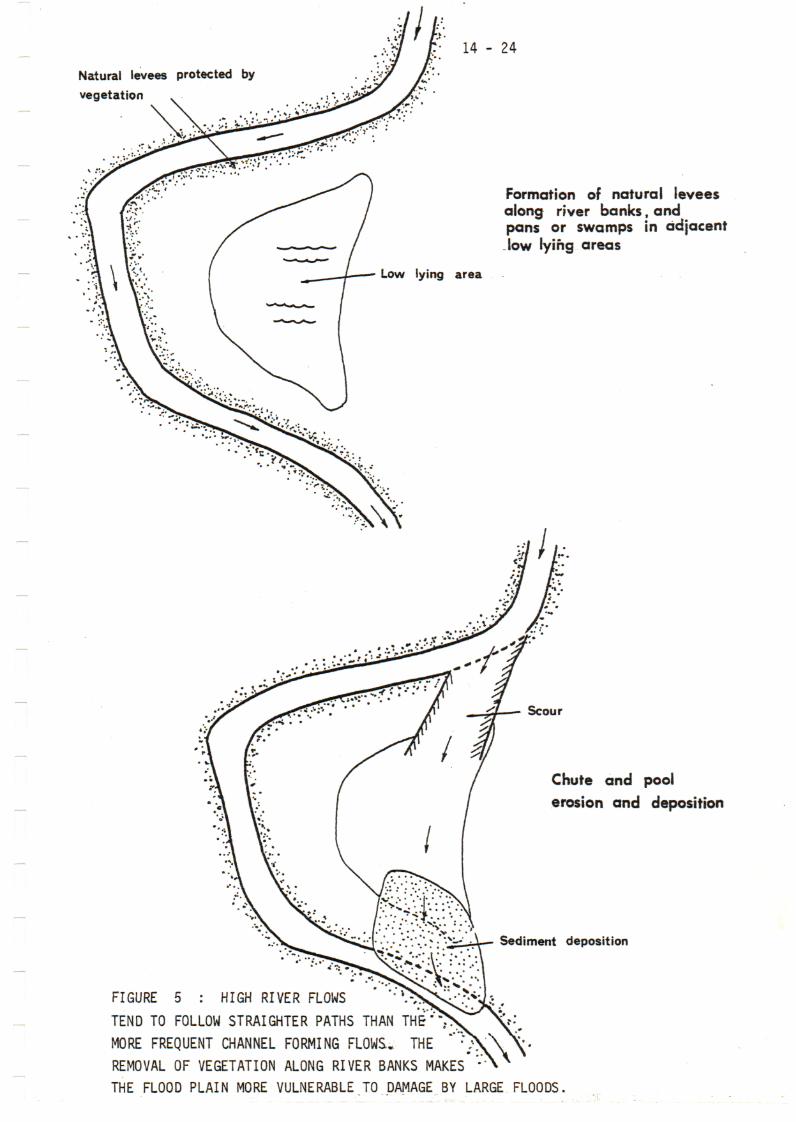
When over-bank flows occur, the flow will tend to short-circuit thebends in the river which represented stable conditions for lesser flows,and follow a straighter and thus steeper path down the valley. One ormore chute channels will develop across the bends and they will carry alarge proportion of the higher flows. The greatly increased slopeacross the bend, together with the orientation of the chute channels,
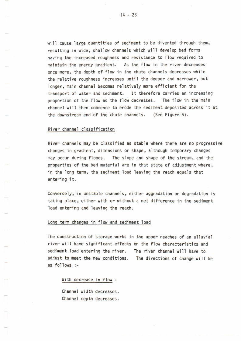
14 - 23
will cause large quantities of sediment to be diverted through them,
resulting in wide, shallow channels which will develop bed formshaving the increased roughness and resistance to flow required tomaintain the energy gradient. As the flow in the river decreasesonce more, the depth of flow in the chute channels decreases whilethe relative roughness increases until the deeper and narrower, but
longer, main channel becomes relatively more efficient for thetransport of water and sediment. It therefore carries an increasingproportion of the flow as the flow decreases. The flow in the mainchannel will then commence to erode the sediment deposited across it atthe downstream end of the chute channels. (See Figure 5).
River channel classification
River channels may be classified as stable where there are no progressivechanges in gradient, dimensions or shape, although temporary changesmay occur during floods. The slope and shape of the stream, and theproperties of the bed material are in that state of adjustment where,in the long term, the sediment load leaving the reach equals thatentering it.
Conversely, in unstable channels, either aggradation or degradation istaking place, either with or without a net difference in the sedimentload entering and leaving the reach.
Long term changes in flow and sediment load
The construction of storage works in the upper reaches of an alluvialriver will have significant effects on the flow characteristics andsediment load entering the river. The river channel will have to
adjust to meet the new conditions. The directions of change will beas follows :-
With decrease in flow :
Channel width decreases.Channel depth decreases.
Natural levees protected by
vegetation
14 - 24
Formation of natural leveesalong river banks, andpans or swamps in adjacent-low lying areas
Low lying area
Scour
Chute and pool
erosion and deposition
Sediment deposition
FIGURE 5 : HIGH RIVER FLOWS
TEND TO FOLLOW STRAIGHTER PATHS THAN THE":
MORE FREQUENT CHANNEL FORMING FLOWS. THE
REMOVAL OF VEGETATION ALONG RIVER BANKS MAKES
THE FLOOD PLAIN MORE VULNERABLE TO DAMAGE BY LARGE FLOODS.

14 - 25
Meander wavelength decreases.
Channel gradient increases.Channel sinuosity increases.
With decrease in sediment load :
Channel width decreases.Channel depth increases.Meander wavelength decreases.Channel gradient decreases
Channel sinuosity increases.
The net effect of dam construction will be a tendency towards a decreasein channel width and meander wavelength but it is not immediately clearin what direction the gradient and depth should change. However,
by including considerations of the width/depth ratio, an estimate ofthe direction of change of depth can be obtained. The width/depth
ratio is predominantly influenced by the type of bed load and decreaseswith decrease in sediment load. This suggests that depth will remainconstant or increase because both width and width/depth ratio decrease.Channel gradient will probably decrease because sinuosity increasesthereby lengthening the channel and decreasing its slope. Bank evasionproblems will be the first symptoms of the changing regime.
The temporary development of chute channels in alluvial valleys hasled to the understandable proposal to divert the main flow into thesestraighter and "more efficient" channels. However, under normal
conditions this will merely create unstable conditions elsewhere in the
reach. Where the regime has been changed by the construction of storageworks these short-circuits would create even greater problems.
14 - 26
7. THE FLOOD PLAIN
The flood plain of a typical aggrading river will consist of cobble
and sand fractions in its upstream end, and sand and silt fractions
at the lower end where stream velocities will be lower and therefore
the bed load particles will be finer.
Meander belts will have occupied the whole flood plain at one time or
another. Fine grained material will have been separated from the
coarser particles and carried to the sea or temporarily deposited on
the part of the flood plain not then occupied by river channels. Thus,
except in deltaic flood plains located upstream of river mouths the
substratum will be composed essentially of sand and gravels with lenses
of finer material where deposition has occurred in slack water outside
the river channel.
When the river flow is less than bank full, the wash load will be
transported through the valley while the excess bed load will be
deposited within the river channel which will gradually rise in elevation.
As the stage of the river rises above its banks, water will flow outward
over the flood plain. The velocity of the water will be checked as it
leaves the river channel and the deposition of coarse material will take
place within a short distance of the channel and parallel to it, forming
natural levees. The finer components of the bed load, together with
the silts and clays in the wash load, will be carried over the remainder
of the flood plain where they will settle out in areas of slack water.
These low-lying areas with their fine sediment deposits are usually the
most agriculturally productive regions of an alluvial valley provided
they are well drained. However, they are vulnerable to flooding
whenever the river banks are overtopped and subject to the ever increasing
danger of the river rapidly switching its course into new channels at
lower elevations away form the existing channel.
14 - 27
VULNERABILITY TO DEPOSITION OF SEDIMENT
By definition the whole flood plain is vulnerable to submergence byfloods and therefore to the deposition of sediment. However, thiscan take place in different ways and to different degrees.
^ubmergence by standing or slow flowing water
Where this occurs, the finer sediments still in suspension will settleout. The grading of the sediment will depend on the velocity of *̂water and its depth, and on the length of time that it was present.In general only light deposition of the clay and silt fractions willoccur.
Several conditions can give rise to this type of deposit :-
(i) The backwater effect of natural or artificial obstacles withinthe flood plain. The following obstacles may contribute tothe general inundation of a large area of an alluvial valleyor river estuary :-
Spring tides.Coastal sand dunes obstructing the river mouth.
A long river course parallel to the coastal dunes beforethese are breached by a flood.
Causeways or bridges across the flood plain, particularlythose with long approach embankments.
(ii) The overtopping of natural or artificial levees and consequent
submergence of the lower lying adjacent areas. These areasoften have to be drained again after the passage of the flood.
Deposits on the river banks
The finer fraction of the bed load (mostly fine sand) will deposit alongthe river banks when they are overtopped and the velocity is checked by
14 - 28
vegetation or changing conditions of flow along most reaches of
rivers in alluvium. In this way natural levees are formed along
the river banks. These are generally at a higher elevation than
the area further away from the river banks.
Deposits in stable sections
The deposition of sediment along the inner banks of curves is part of
the normal process of channel migration. These deposits occur within
the channel where they cause no harm, other than constricting the flow
and aggravating the erosion of the opposite bank.
Deposits in unstable sections
Heavy depositions of all fractions of the bed load may occur in unstablesections of the river. The instability may only be temporary (forexample when bends are short-circuited by high flows) or permanent(where the river is actively changing its course).
Summary
Sediment deposits within the river channel cause no immediate harm.The deposition of sediment outside the channel only takes place duringtimes of high flood when overbank flow occurs. Therefore damage dueto the deposition of sediment will only commence when the flow exceedsthe capacity of the river channel. Damage will increase in severitywith increase in the size of the flood.

14 - 29
9. VULNERABILITY TO EROSION
Erosion occurs in two basic forms. The caving of the outer banks ofriver bends is part of the normal channel migration that takes placein all alluvial rivers. Erosion outside the river channel (calledchute erosion for want of a better name - I can't find any referenceto it in the literature) can only take place once the banks areovertopped. The normal scouring of the river channel causes no directharm as the conditions return to normal after the passage of the flow.
Bank erosion
Bank erosion is the most destructive foroe at work within an alluvial•valley. The harm it does is usually irreparable and at best it isonly possible to stabilise the bank to prevent further erosion. Whileit may be possible to induce sediment to deposit within areas where thebank has been eroded, it is obvious from the discussion above that thissediment will comprise bed load material and not the finer, more fertilefractions which may previously have been present in the bank.
Bank erosion will commence as soon as the flow in the river occupies thewhole width of the channel. The erosion will become progressively worseas the river rises, reaching a maximum when the river approaches bankfull discharge. By then, due to the higher average velocity, thethalweg will tend to follow a less sinuous course and the zone ofmaximum velocity will tend to draw away from the bank of the river.Once overbank flow occurs, there will be a radical change in the velocitydistribution within the river channel and progressively less concentrationof flow along the outer bank of the river, thus lessening the bank erosion,
While this lessening of bank erosion with increasing discharge may seemillogical, it has been reported by a number of investigators, and Ihave seen it myself in laboratory model studies, and in the field in theGamtoos Valley.
At high river stages, particularly high rising stages, the zone ofmaximum current (thalweg) impinges on the outer river bank of a bend
14 - 30
further downstream than during lower stages and its angle of attackincreases with increase in stage. During falling stages below bank fulldischarge the thalweg is more parallel to the outer bank and closerto it than on rising stages. This latter characteristic is the maincause of bank erosion and is an important consideration in determiningoptimum flood protection measures. It is probably due to the fact thatthe general river slope, especially the slope at the bends, is higherduring high stages and rising flood stages than during the falling stages,In my view it is also possible that during the rising stages the overallresistance to flow offered by the river bed is high due to the presenceof eroded remnants of previous bed forms, whereas during the fallingstages a more uniform bed form offers less resistance to flow. Thezone of maximum current therefore has to follow a more sinuous (andtherefore longer) course in order to lose the energy that was previouslylost by roughness of the channel bed.
Conversely, the steep energy gradient on the rising and high stages givesrise to higher velocities which in turn tend to follow straighter courses,Where overbank flow occurs and bends are short-circuited, severe chuteerosion is caused by these high stream velocities.
The fact that the channel is exposed to high flows for a longer periodduring the falling stage of the hydrograph, and the saturation of thebanks during peak discharge further aggravate the problem.
The general picture of bank erosion therefore is that it starts once theriver rises above bed full level and commences attacking the upstreamend of the outer bank of the curve. As the flow continues to increase,the point of maximum erosion moves progressively downstream along thebend, and the severity of the erosion increases. Once overbank flowoccurs, an increasingly large proportion of the flow crosses the bankinstead of being deflected by it, and bank erosion will decrease dueto the resulting change in the velocity distribution and angle ofattack. As the flow decreases, the process is reversed except thatfor the same flow, erosion is more severe than on the rising stage.

1- - 31
Chute erosion
Where overbank flow occurs in straight reaches or the outer banks ofbends, sediment will be deposited on the bank due to the reductionin velocity. However, where bends are short-circuited, the energygradient will be much greater due to the shorter path that the watertakes. This gives rise to erosion which is usually at a maximum inthe areas where the flow overtops the banks. Chutes and pools willbe the typical bed forms in the overbank channels. Erosion mayoccur along the whole length of the shorter channel for part or thewhole of the time, or sediment may be deposited at its lower end oreven in the main river channel where it will be eroded away by bankerosion during the falling stages.
Summary
The deposition of sediment may be beneficial in some areas or causedamage where the deposits are deep, or where it consists mainly of thecoarser fractions. In most cases the damage is not permanent.However, erosion nearly always causes permanent damage to the erodedareas, and in addition it exposes other areas to damage by furturefloods.
While sediment deposition and chute erosion only occur with high floodswhich overtop the banks, bank erosion is most severe with only moderateflows in the river.

14 - 32
10. HYDROLOGY
The shape and location of a river channel is primarily the result offlowing water. The magnitude and frequency of runoff is thereforeof major importance in determining the character of a river channel.For example, river channels characterised by high peak discharges canbe very different from those with relatively uniform flow, althoughboth rivers may have the same mean discharge. Both the magnitudes anddurations of river flows are therefore important factors in the problemsof river mechanics. The fact that both of these are radically changedby the construction of storage dams in the catchment makes it doublynecessary to understand the role of the hydrology of a river in problemsof flood damage and river stabilisation.
The relationship between river flow and damage due to sedimentation anderosion summarised earlier in these notes is shown diagramatically inFigure 6 for a hypothetical flood of 5 000 m3/s and assumed bed fulland bank full capacities of 500 and 1 000 m3/s respectively.Obviously these will vary with the reach of river being considered, butconditions in major rivers are of this order, except that theriver mass flow into chute channels eroded by the last flood at flowsless than 1 000 m3/s. However, with time the river will hopefullyseal off the entrances to the channels by natural levee deposits, soincreasing the value of the flow required to breach them again.
From this diagram it is clear that one method of preventing any flooddamage in this valley would be to ensure that flows never exceeded500 m3/s. Alternatively, if the banks are protected flows of up tosay I 000 m3/s can be tolerated. In order to provide full protectionat flows exceeding 1 000 m3/s both bank protection works and leveesto contain the river within the channel would be required.
Much then depends on the natural hydrology of the river and the extentthat this can be modified by the construction of dams in the catchment.

O
8.o^
f> o*-H>
•n cr>I— 70
s io >
»—iT3 O
3>
COm
O
O-n
—im
o00
i
m
ooo
o>3>
•gc
Flood plain erosion
I(.Deposition of 'sediment
ee - n

14 - 34
Other problems associated with the construction of dams are thatthey trap the bed load and that the water passing through them isunsaturated with bed load sediment. This will enhance channelerosion, particularly in the upper reaches of the valley.
14 - 35
11. PRINCIPLES OF CHANNEL STABILISATION
A number of factors are involved in any channel stabilisation project.Most of these are related to channel geometry. It is important thatthe probable effects of any structure at high, intermediate, and lowflows be understood and taken into account when determining the propertype, position, alignment and elevations of channel stabilisationstructures. In addition, it should always be borne in mind that channelimprovement in one section of a river may merely transfer the problemto the next bend or crossing, and it may be necessary to extend theprotection right down to the nearest stable river section.
Two classes of solution to a particular problem are :-
1. Designs which stabilise the channel in its natural material.
2. Designs which stabilise the channel by means of non-erodablestructures or lining.
Before considering these, it is necessary to determine which aspects ofthe channel require correction.
Channel shape
This can be changed mainly by controlling the alignment and type ofstructure. Relatively smooth impermeable longitudinal groynes willtend to result in a narrower and deeper channel than spur dykes andjetty fields.
The optimum channel width is the maximum which will provide a crosssection free from obstructing bar formations at normal low discharge.A channel that is too narrow will be subject to excessive bed scour andpossibly undermining of the control works. A channel that is too widewill permit random shifting of flow lines which will result in theformation of sand bars that are unstable both as to location andconfiguration. Such a channel will be inefficient, points of attack
14 - 36
will be unpredictable and variable, and the bars may encourage vegetativegrowth and accumulation of driftwood which may constrict the channel andcause local flooding.
In a river which has a large variation between low
and high flows, the high flows develop a wide channel within which thesubsequent low flows form a braided or random meander pattern. This isundesirable for the reasons mentioned in the preceding paragraph, and itis best to provide low-water control works within the major channel whichwill fix the areas of attack, and then to protect these against erosion.
Depth of flow depends primarily on the discharge, but also on thecredibility of the bed and bank material, and the energy slope. If thebed and banks are easily erodible, then more energy will be expended inbank caving and thus more meandering, than scouring out the bed togreater depths. The longer a pool is held in one position by a cohesiveor non-erodable bank, the deeper it is scoured until the optimum depthis reached.
*
In general, resistance to flow will increase with increasing width/depthratio, being at a minimum in the deeper bends and a maximum in theshallower crossings.
Channel slope and sinuosity
At each change in the channel slope the river will attempt to adjust itslength by becoming more or less sinuous in order to maintain a slopewhich will be compatible with the hydraulic variables needed in the reachfor sediment and water transport. There are tolerable limits of watersurface slope within which the hydraulic variables will adjust tomaintain good geometric characteristics. The river will adjust to astabilised condition more quickly the closer the imposed condition areto the optimum.
The confinement of a channel will steepen the slope, while increasedroughness provided by spur dykes will flatten it. However, under theseconditions other factors may also change to restore the equilibrium.
14 - 37
Channel contraction
This is one of the more important measures used for channelstabilisation. For example, by building a jetty field in front of acaving bank the channel is contracted and transverse slopes are increased,resulting in the movement of large quantities of sediment from thechannel into the field. The channel becomes more efficient fordischarging both water and sediment. Sediment not deposited withinthe field is moved downstream where it will be deposited and may resultin a wider bed with steeper slopes. In most cases this will not poseany problem. If it does, then the field will have to be extendedinto the threatened area.
Also, it is often desirable to close or restrict flow through secondarychannels in divided flow reaches or chutes through bends in order toprevent further erosion in their channels and deposition of sediment inthe area between them.
Channel alignment
For stabilisation purposes the radii of bends should be selected from anexamination of the river to ascertain the curvature that will not subjectthe banks to extreme attack and yet will be sufficient to hold thethalweg in a fixed location.
In planning tangent lengths between reversing bends, it must be borne inmind that the principal current must pass from the inside of the upstreambend over the crossing to .the concave side of the next downstream bend.An acute angle between this current and the bank of the downstream bendwill require high maintenance or more costly works there, and the areamost serious attack will depend on the angle. Generally this angleshould be limited to a maximum of 15 degrees though, where this isimpracticable, angles of up to 25 degrees may be used. The minimumtangent lengths that are likely to retain this angle below the limitsmentioned should be selected. This is most important because tangents
14 - 38
that are too long may result in additional attempts of the river tomeander, eventually upsetting the planned alignment or causing undue
expense to retain it.
The new channel position will have to be maintained by revetments ofdykes to prevent erosion in the new bends. Longitudinal dykes orjetty fields can be used to close off old channels and so concentratethe flow, and also to resist the tendency of the river to return toall or portions of its old alignment.
For a stabilisation system to be most effective, it must be an integratedsystem for the entire length of the reach to be protected. Spotstabilisation will often result in high maintenance and repetitiveconstruction. Even with the best planned system, additional constructioncan seldom be avoided as the action of a river after the plannedconstruction has been completed cannot be accurately forecast.
However, where channel problems or bank erosion occurs only at isolatedlocations, correction at these locations may be the economic answereven if the high maintenance costs are accepted.

14 - 39
13. REFERENCES
FENWICK, G.B. : State of knowledge of channel stabilisation
in major alluvial rivers. US Corps of Engineers. 1969
ROOSEBOOM, A. : Riglyne vir die beskerming van waterlope teen
uitskuring. Division of Hydrology. Technical Report
No. 64. 1974
SHEN, H.W. : River Mechanics. Colorado State University.
1971
Division of Hydrology
Pretoria
September, 1971
Revised March, 1976
Second revision, May 1982