CHAPTER 2 Rethinking Urban Growth Boundaries: Fo llowing ...
22
CHAPTER 2 Rethinking Urban Growth Boundaries: Following the Transportation Corridors Dr. Elizelle Juaneé Cilliers North-West University, Unit for Environmental Sciences and Management. Abstract Modern urban areas are highly complex entities and constantly need to deal with interrelated processes of urban change. The forces of rapid urbanisation and increasing population growth initiated changes to the urban form of modern urban areas. The management of urban form was always placed at the forefront of urban planning, as it was evident that urban form determines the effectiveness of cit- ies, the accessibility it offers and the integration between spheres. Various growth management tools were introduced to contain, control, direct or phase urban growth in this regard. Urban growth boundaries (UGBs) were soon to become one of the most popular urban growth management tools, supported by the smart growth approaches. However, recent development challenges suggest that the urban environments are becoming more complex and urban form is increasingly influenced by the growing economic sector, and especially the expanding trans- port networks which operate across boundaries and between local jurisdictions. The one-dimensional approach of growth management and UGBs are questioned, especially within developing countries that are in no position to limit the much needed urban growth to support the local economy. It has furthermore become evident that transport plays a major catalytic role in achieving urban reform, and that land-use and transportation planning are highly interlinked urban determi- nants. Modern cities suggest of multi-nodal areas, characterised by transportation networks which are not bound to UGBs. The relevance and effectiveness of tradi- tional growth management tools were evaluated within the urban space economy of the Gauteng City Region. The case study illustrated the challenges associated with growth management tools to structure urban form, against the background of increased economic development and expanding transportation networks. Keywords: Urban growth boundary, transportation networks, urban form. www.witpress.com, ISSN 1755-8336 (on-line) WIT Transactions on State of the Art in Science and Engineering, Vol 86, © 2015 WIT Press doi:10.2495/978-1-84566-077-2/002
Transcript of CHAPTER 2 Rethinking Urban Growth Boundaries: Fo llowing ...

CHAPTER 2
Rethinking Urban Growth Boundaries: Fo llowing the Transportation Corridors
Dr. Elizelle Juaneé CilliersNo rth-West Un iversity, Un it for En vironmental Sciences and Ma nagement.
Ab stract
Modern ur ban areas are highly complex entities and constantly need to deal with interrelated processes of ur ban ch ange. The forces of rapid urbanisation and increasing population growth initiated changes to the ur ban form of modern ur ban areas. The ma nagement of ur ban form was always placed at the forefront of ur ban planning, as it was evident that ur ban form determines the effectiveness of ci t-ies, the accessibility it offers and the integration between spheres. Various gr owth ma nagement tools were introduced to contain, control, direct or phase ur ban growth in this regard. Urban growth boundaries (UG Bs) were soon to become one of the most popular ur ban gr owth ma nagement tools, supported by the sm art growth approaches. However, recent de velopment challenges suggest that the ur ban environments are becoming more complex and ur ban form is increasingly infl uenced by the growing ec onomic sector, and especially the expanding tr ans-port networks which operate across boundaries and between local jurisdictions. The on e-dimensional approach of gr owth ma nagement and UG Bs are questioned, especially within de veloping countries that are in no position to limit the much needed ur ban growth to support the local economy. It has furthermore become evident that tr ansport plays a major catalytic role in achieving ur ban reform, and that la nd-use and tr ansportation planning are highly interlinked ur ban determi-nants. Modern ci ties suggest of mu lti-nodal areas, characterised by tr ansportation networks which are not bound to UG Bs. The relevance and effectiveness of tradi-tional gr owth ma nagement tools were evaluated within the ur ban space economy of the Ga uteng Ci ty Region. The case study illustrated the challenges associated with gr owth ma nagement tools to structure ur ban form, against the background of increased ec onomic de velopment and expanding tr ansportation networks.
Ke ywords: Ur ban growth boundary, tr ansportation networks, ur ban form.
www.witpress.com, ISSN 1755-8336 (on-line) WIT Transactions on State of the Art in Science and Engineering, Vol 86, © 2015 WIT Press
doi:10.2495/978-1-84566-077-2/002

20 LAND USE MANAGEMENT AND TRANSPORTATION PLANNING
1 In troduction
The world’s population balance has shifted. In 2008, for the fi rst time in history, more people lived in ci ties than in rural areas [1]. Urbanisation has accelerated from only 2% living in ur ban areas in 1800 to half the world’s population of 3 bil-lion people, with tw o-thirds of the world expected to live in ci ties by 2050 [2]. As a city grows to absorb immigration and natural growth, the city expands beyond its defi ned boundaries into the sphere of infl uence of neighbouring ci ties, and ur ban and pe ri-ur ban areas [3].
These de velopment trends are responsible for the changes in our current ur ban environments, for the increasing quantitative developments and decreasing quali-tative environments.
It is widely accepted among ur ban restructuring advocacy groups and policy makers that the current local trends and the resulting sp atial ur ban form have cer-tain im plications or consequences on the way in which our ci ties function. These consequences can be seen in settlement patterns that are grotesquely distorted, inconvenient and dysfunctional ur ban environments, the lack of effi cient and via-ble public tr ansportation, costly installation and maintenance of engineering ser-vices and the fact that ci ties have become hostile places to live in [4, 5]. Over the past couple of years, very little has been done to address the existing dispersed sp atial pattern; it has rather been reinforced by existing sp atial planning practices placing untold pressures on existing engineering in frastructure, bulk services and pu blic tr ansport.
The ma nagement of ur ban form was placed at the forefront of objectives for ur ban planners and managing authorities worldwide, as it was believed that the ur ban form determines the effectiveness of ci ties, the accessibility it offers, the integration between spheres, the la nd use and possible layout plans [6]. The realisation of the importance of ur ban form, and the ma nagement thereof, led to the creation of gr owth ma nagement tools such as the ur ban growth boundar-ies (UG Bs).
Recent de velopment challenges suggest that the ur ban environments are becom-ing more complex and ur ban form is now infl uenced by the growing ec onomic sector, and especially the expanding tr ansport networks which operate across boundaries and between local authorities. The tr ansportation in frastructure is inti-mately linked to ur ban sp atial planning and la nd use [7] and should, therefore, be incorporated when considering ur ban form.
Given not only the intense fl ow of people but also information, trade, fi nances and resources between ci ties, a traditional approach to planning and governance is increasingly untenable. A new approach to planning and managing these bur-geoning ur ban areas is required [8]. This ch apter will evaluate the relevance and effectiveness of gr owth ma nagement tools to structure ur ban form, against the background of modern ur ban environments, characterised by forces of rapid urbanisation, population growth, increased ec onomic de velopment and expand-ing tr ansportation networks which are not bounded by ur ban de velopment boundaries.
www.witpress.com, ISSN 1755-8336 (on-line) WIT Transactions on State of the Art in Science and Engineering, Vol 86, © 2015 WIT Press
RETHINKING URBAN GROWTH BOUNDARIES: FOLLOWING THE TRANSPORTATION CORRIDORS 21
2 Ur ban Form
Ur ban form refers to the shape of ur ban environments, not simply in terms of appearance, but more importantly in terms of the defi ning characteristics, such as the design and structure, where de velopment occurs, wh at type of developments are likely to realise, wh at types of public green spaces are available, and the inter-connection of these areas [4, 5]. Good ur ban form thus requires good, coordinated and integrated planning. For a decentralised system to work effectively, coopera-tion is required at the local level between formal governmental institutions and the range of le ss-formal, no n-governmental organisations and co mmunity-based organisations [6].
The European vision considers the concept of compact ci ties as ideal places to live and experience the vitality and variety of ur ban life. The reasons offered for making ci ties more compact have changed in the last 150 years. First, it was for resource conservation, social interaction, waste minimisation and effi ciency, but it has moved over to su stainable ur ban form, and ec onomic, social and political issues. Contemporary co mpact city approaches are said to increase bu ilt-area and residential population densities, to intensify ur ban ec onomic, social and cultural activities and to manipulate ur ban size, form, structure and settlement systems in pursuit of the environmental, social and global sustainability benefi ts derived from the concentration of ur ban functions [9].
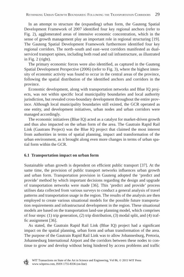
Rogers [10] maintains that a su stainable ur ban form is based on a series of inter-linked compact nodes or neighbourhoods (refer to Fi g. 1). These neighbourhoods
Figure 1: The compact sus tainable urb an form. Sou rce: Rog ers [11].
www.witpress.com, ISSN 1755-8336 (on-line) WIT Transactions on State of the Art in Science and Engineering, Vol 86, © 2015 WIT Press
22 LAND USE MANAGEMENT AND TRANSPORTATION PLANNING
grow around centres of social and ec onomic activities located at pu blic tr ansport nodes. This results in a co mpact city form, which can then be defi ned as a network of these neighbourhoods, each with its ow n parks and public spaces and accom-modating a diversity of overlapping private and public activities [11] subject to the distance between the facilities.
In this sense, urb an form is subject to two core forces that are responsible for this cha nge in the urb an env ironment: (1) force of containment, a centripetal force ensuring the compactness of the city, driven by accessibility, entertainment, social life and integration; and (2) force of sprawl, a centrifugal force resulting in the expansion of the city, driven by costs of land, individual privacy, open spaces, cor-ridor developments and improving tra nsportation means.
The reality in many dev eloping countries illustrates fragmented and dispersed urb an form, as a result of urb an sprawl and uncontrolled dev elopment. The dis-persed urb an growth is believed to have many adverse fi nancial, social and envi-ronmental impacts, and it is believed not to be sustainable in the medium to longer term [12]. Local authorities thus drive the com pact-city approach, in search of the increased urb an performance that will result from the com pact-city urb an form, not questioning the relevance of the Eur opean vision of compact urb an form within dev eloping countries, or the effectiveness thereof in the modern (technology and tra nsport-orientated) urb an environments. Urb an form is still guided in most cit ies, by the compaction approach, implemented and managed by means of gro wth man- agement tools to limited urb an growth between set boundaries, with the objective of cre ating the ideal and sus tainable urb an form.
3 Gro wth Man agement and Sma rt Growth
In an attempt to contain urb an growth and manage the existing and developing urb an form, mechanisms and gro wth man agement tools were created, linked to the concept of sma rt growth, supported by policies intended to promote ‘sus tainable urb an form’. Accordingly, the role of gro wth man agement tools, specifi cally the UGB s, will be discussed, followed by the sma rt growth approach, as it currently manifests in various cit ies worldwide.
3.1 Urban growth boundaries
UGBs are defi ned as ‘a pro- active grow th mana gement tool that seeks to con-tain, control, direct or phase growth in order to promote more compact, contigu-ous urba n deve lopment’ [13]. Since the first UGB wa s established in Lexing ton, Kentuc ky, USA, i n 1958 [14], UGBs h ave become one of the most popular urban growth manage ment tools. By 1999, more than 100 cities and counties in the USA ha d adopted UGBs [ 15].
Portland’s UGB is perhaps the most mentioned UGB in the urban planni ng lit-era ture, as it has been in the centre of controversy for the past two decades between the pro-ma rketeers and government intervention advocates [15]. On the one hand,
www.witpress.com, ISSN 1755-8336 (on-line) WIT Transactions on State of the Art in Science and Engineering, Vol 86, © 2015 WIT Press

RETHINKING URBAN GROWTH BOUNDARIES: FOLLOWING THE TRANSPORTATION CORRIDORS 23
compaction was promoted, along with preserved open spaces and environmentally sensitive areas, and on the other hand, UGBs w ere criticised as they can easily yield undesirably draconian outcomes, because they are not directly linked to the underlying market failures [16]. In spite of numerous UGB st udie s conducted on the Portla nd UGB, t here is no agreement about its effectiveness [15].
Recently, the effectiveness and relevance of UGBs w ere questioned. The ‘prom-ised’ objective to manage growth and promote urban and environmental effi ciency, effectiveness and economy in the interest of all [17] did not seem to realise as a direct result of the implementation of UGBs. This might be linked to problems associated with the actual implementation of the UGBs, which was regarded as a rigid legislative imperative, due to its stringent application as a cadastral line which determined delineation between urban areas and rural areas. Further con-cerns were raised about the practicality and functionality of the UGBs, especially in terms of their role in increasing the price of land, due to the restriction of land availability, resulting in land speculation. It has furthermore led to develo pment applications being considered based on location [18], and not part of the overall rationale or ad hoc status.
Research by McShan e [13] strengthened the scepticism as it proved that the cit-ies with the least affordable housing, the most congestion and the slowest growth rates are those which have adopted UGBs a nd the policies which go with them. It has since been understood that densifi cation and compaction around public trans-p ort nodes is probably the most proact ive mechanism to curtail unwanted growth and densify the city. This has redirected the focus of growth manage ment to a broader spectrum of mechanisms where managing urban growth is about acting in line with the market, through bending and shaping it to achieve desirable outcomes [19], in line with the objectives of smart growth.
3.2 Smart growth
The smart growth concept supports the compac t-city approach, and prioritises densifi cation and growth manage ment. The smart growth concept presumes that if the urban form is uncontrolled, the boundaries will be misshapen, intermittent, ad hoc or out of control [13]. This concept offers an alternative to sprawl [20], by referring to a set of planning princi ples intended to increase land u se and transp or-tation system effi ciency [20].
Smart growth emphasises compact develo pment and accessibility [21, 22], while sprawl emphasises mobility (physical movement) and auto-m obility (move-ment by vehicles) [20]. The smart growth approach is aimed at higher -density urban develo pment and clustered activities within a mixed land u se. It focuses on the human scale and promotes facilities within walking distance, thus emphasising the public realm. On the other hand, various criticisms of smart growth include the claims that it harms consumers, infringes on freedom, increases traffi c congestion and air pollution, reduces housing affordability, causes social problems, increases public service costs, requires wasteful transit subsidies and is unjustifi ed [20].
www.witpress.com, ISSN 1755-8336 (on-line) WIT Transactions on State of the Art in Science and Engineering, Vol 86, © 2015 WIT Press

24 LAND USE MANAGEMENT AND TRANSPORTATION PLANNING
Major differences between compact land-u se patterns (driven by smart growth) and urban sprawl patterns are compared in Table 1.
The core problem of urban sprawl, which the smart growth approach intended to address, does not turn out to be problematic after all, but rather a refl ection of the decisions made by many people who like the amenities of suburbia, and there-fore has no rationale as to why smart growth values should be preferred over the values of those who like suburbia [24]. This questions the effectiveness and rele-vance of the smart growth concept in general.
3.3 Comparison of growth management and smart growth approaches
Table 2 presents a summary of the comparison between growth management and smart growth approaches in terms of the similarities, advantages and disadvan-tages of the two approaches.
As the growth management concepts were developed in fi rst-world countries, another issue to consider is the relevance and effectiveness of the growth manage-ment concepts (and smart growth approach) in areas characterised by urban sprawl and fragmented urban areas, such as most of the cities in developing countries. While planning a new urban area, the smart growth approach can be implemented, but can the same be said for an already established area, which emerged spontane-ously, without any densifi cation strategies?
4 Growth Management in Developing Countries
The European vision that compact cities are the ideal urban form and can con-tribute to the attainment of sustainable cities [25] is supported by concepts of
Table 1: Smart growth -driven approach versus sprawl features.
Issues Compact Sprawl
Density High density, clustered activities
Lower density, dispersed activities
Land use Mixed Single use, segregatedScale Human scale Large scalePublic
facilitiesLocal, distributed, within
walking distanceRegional, consolidated, requires
automobile accessTransport Multi-modal Automobile-orientatedConnectivity Highly connected roads Hierarchical, unconnected networkStreet design Accommodating a variety of
activities, traffi c calmingMaximising motor vehicle traffi c
volume and speedPlanning
processPlanned and coordinated
between stakeholdersUnplanned, with little coordination
between stakeholdersPublic spaces Emphasis on the public realm Emphasis on the private realm Source: Litman [20], VTPI [21] and SGN [23].
www.witpress.com, ISSN 1755-8336 (on-line) WIT Transactions on State of the Art in Science and Engineering, Vol 86, © 2015 WIT Press

RETHINKING URBAN GROWTH BOUNDARIES: FOLLOWING THE TRANSPORTATION CORRIDORS 25
structured and integrated planning approaches. The reality in developing coun-tries, however, suggests that most urban areas have not been planned and lack prescient ground design. The compactness of these urban areas (in the few cases where it does exist) has emerged spontaneously, if not chaotically [9].
The idea of a compact city therefore has serious obstacles in developing coun-tries. These obstacles include the current survival strategies of the poor that neces-sitate lower building densities, the freedom and power afforded to private landowners and developers within the capitalist market system, the lack of devel-opment-control measures to ensure that development takes place at higher densi-ties at central localities and with mixed uses and the anti- urban mindset of both rich and poor. The combination of these forces has resulted in the three spatial characteristics of low density, fragmentation and separation. Furthermore, urban economists around the world are virtually of one mind in their conviction that the fi rst and most important step in improving housing affordability in cities around the world is the removal of unnecessary restraints on the supply of land, and, in particular, the removal of UGBs [13]. In this sense, arguments in favour of UGBs were questioned when considering the practicality and implementation of these growth management tools in developing countries. Arguments include, but are not limited to, the following:
• Aesthetic and green-planning arguments deem UGBs ‘necessary’ because it marks a clear boundary line between urban and rural areas: This line does not, however, guarantee a qualitative environment, but often results in developed
Table 2: Comparison of growth management and smart growth approaches.
Comparison Growth management Smart growth
Similarities Compact development High-density, clustered activitiesContain and limit urban sprawl Manage land use and urban sprawl Proactive management tool Proactive management tool
Advantages Division between urban and rural areas
Mixed land-use developmentHuman scale development
Strict enforcement Land-use effi ciencyPreserved open spaces Transportation system effi ciencyNode development Integrated development approach
Disadvantages Development applications based on rigid line and location
Needs strict zoning controls to ensure successful implementation
Implementation diffi culties Infringes freedom of developmentRestrict land availability Reduces housing affordabilityIncrease speculation and land
pricesNot in line with market
demand
Causes social problemsIncreases public service costs
www.witpress.com, ISSN 1755-8336 (on-line) WIT Transactions on State of the Art in Science and Engineering, Vol 86, © 2015 WIT Press

26 LAND USE MANAGEMENT AND TRANSPORTATION PLANNING
and undeveloped (neglected) areas [13]. The developing countries are in need of a developmental approach, not a conservation approach [4, 5].
• Economic arguments claim that UGBs provide developers with best-location options and prevent speculation in land: The reality is that speculation is begin-ning to increase within the borders of the UGB as vacant land within the UGB is becoming more scarce and valuable [13].
• Sustainable urban form arguments state that UGBs provide structure and form to urban environments: Forcing people into such patterns requires coer-cion and it is not long before the people start moving out of these ‘control zones’ to where they can more freely express their individual choices. In developing countries, many have to move because the scarcity of land prises them out of the local housing market and, in many instances, spatial dispari-ties are widening [26]. Instead of accommodating the inward migration of people from rural surroundings using densifi cation techniques, the urban expansion was enhanced by making more, less-expensive land available for development on the periphery of the city, strengthening affordability in devel-oping countries.
• Promoting inner-city redevelopment arguments claim that UGBs are necessary to promote the revitalisation of inner cities: Ironically, the enthusiasm for den-sity at any price has allowed over- development and a glut of sub-standard apart-ment blocks [13].
Apart from these arguments, the implementation of growth management and UGBs in developing countries is questioned from the broader economic perspec-tive and transportation network perspective. First, developing countries are in no situation to ‘restrict’ or ‘prevent’ urban development, as they are dependent on the economic development and growth to sustain themselves and ensure food and live-lihood to their residents. Second, transportation considerations have also brought along a new dimension to urban planning, as transportation and land use are (and being increasingly more) interconnected. Transportation provision was not (and will never be) subjective to municipal boundaries, but rather enhanced the crossing of boundaries and linking of the various nodes.
5 Transportation and Its Impact on UGBs
Modern urban areas are highly complex entities and constantly need to deal with interrelated processes of urban change. The most popular types of models used to illustrate urban change have been those dealing with the relationship between transportation network growth and changes in land use and the location of eco-nomic activity, embodied in the concept of accessibility [27].
Transportation networks and the spatial patterns of land use they serve are assumed to mutually infl uence each other over time. Changes to transportation networks, such as the construction of a new link or expansion of an existing one, eventually infl uence the location of investment in land, which in turn infl uences the demand for travel to and from a particular location. This relationship is
www.witpress.com, ISSN 1755-8336 (on-line) WIT Transactions on State of the Art in Science and Engineering, Vol 86, © 2015 WIT Press

RETHINKING URBAN GROWTH BOUNDARIES: FOLLOWING THE TRANSPORTATION CORRIDORS 27
sometimes referred to as the transportation–land-use ‘link’ or ‘cycle’, emphasising a feedback relationship [28].
The promoters of smart growth believed that, by increasing compaction and congestion and forcing people to live at high densities in mixed-use neighbour-hoods, people would abandon their cars and walk, cycle or ride on buses and trains. However, behaviour patterns and consumer trends revealed that more than 90% of people in large cities want other people to use public transport [13], but are not willing to sacrifi ce personal convenience and luxury.
Reality reveals that modern cities suggest of typically multi-nodal areas, charac-terised by transportation and transport routes which are not subjective to the UGBs. If an urban area restricts the use of private motor vehicles, residents abandon the city and move somewhere else, as modern societies are car-dependant, and it is no longer negotiable to plan for adequate transportation provision within cities.
It has become evident that transport has a major catalytic role to play to achieve urban reform, and that land-use and transportation planning are highly interlinked urban determinants [19]. However, opportunities to create sustainable, environmen-tally friendly communities are being missed because transport provision and fund-ing are still too dislocated from the overall planning process [10]. Spatial planning and transportation planning should in this sense be more integrated and planned holistically as transportation not only stimulates economic development but also helps structure space, and thus urban form. The relationship between transport and spatial organisation can be considered from three major geographical scales, namely global scale, regional scale and local scale [29]. Global spatial organisation seeks to explain global differences in growth and accessibility, assuming that the global spatial organisation favours a few core areas that grow faster than the periph-ery, thus identifying poles based on favoured geographical concentration. Regional spatial organisation is based on the central place model, which tries to fi nd the relationships between the size and the geographic distribution of cities in a region. Transportation is particularly important as the organisation of central places is based on minimising the friction of distance, and transportation is regarded as a factor of accessibility that reinforces the importance of poles. Local spatial organ-isation is focussed on important elements which shape the local urban spatial organisation, such as employment zones and attraction zones. The growing disso-ciation between the workplace and the residence is believed to be largely due to the success of motorised transport, notably the private automobile [29]. The impact of transportation on urban form and growth management was evaluated from the case study of the Gauteng City Region ( GCR), as presented accordingly.
6 The GCR Case Study
Current urban settlement formation in the developing urban areas of South Africa tends to be very poor in terms of quality, service provision and standards. These environments have very little chance of developing into vibrant, enriching and effi cient urban environments [30]. While the reasons for poor environmental qual-ity are undoubtedly diverse and complex, having political, economic and social
www.witpress.com, ISSN 1755-8336 (on-line) WIT Transactions on State of the Art in Science and Engineering, Vol 86, © 2015 WIT Press

28 LAND USE MANAGEMENT AND TRANSPORTATION PLANNING
dimensions, it is argued that the prevailing approach to layout planning in South Africa is part of the problem.
Settlement characteristics of Gauteng are similar to those of most South African cities, including a multi-nodal and spatially fragmented urban structure, attendant decentralisation and decline of the inner-city and low-density sprawl, separation of functions and a motorcar-dominated road network, ribbon development along highways, unbalanced city growth with most of the economic activity in the centre and south-east, over-emphasis on low-density housing provision often peripher-ally located and segregation and inequality [4]. The urban nodes developed spon-taneously and were not a result of detailed planning. These nodes, although mono-functional, soon became mixed in terms of use [31].
Gauteng was (and is still) the most densely populated province in South Africa, with the highest gross geographic product ( GGP) and highest GGP per capita. Despite being the economic heart of South Africa, extensive research carried out by the Gauteng Department of Finance and Economic Affairs in 1997 revealed that the economic performance of the province was worsening, specifi cally, from 1985 to 1995 when unemployment was steadily rising, labour absorption rates were below 1%, standard of living had been decreasing and the economic growth was at an average of 1.4% a year [32]. It was found that Gauteng’s poor economic perfor-mance was a result of the prevalence of the mining resource-exploiting industries and low value-added manufacturing. An alternative path of economic development was proposed, focusing on high-tech industries, transportation and high value-added manufacturing and tourism [33].
In 2001, the Gauteng province in South Africa devised and implemented an initiative called ‘ Blue IQ’ to stimulate economic growth in the province through public investment in strategic economic infrastructure [32]. The Gauteng Legisla-ture confi rmed Blue IQ’s institutional beginnings as an infrastructure investment vehicle in October 2003 [33]. Blue IQ comprised 11 projects from the four target sectors, including tourism, technology, transport and high value-added manufacturing.
Gauteng’s ‘ urban space economy’ ( economic activity in space, considering how the spatial form of cities is structured by dynamic changes in economic activity; how economic opportunities and constraints are structured by spatial form; and the changing nature of economic space itself) [34] was dramatically infl uenced by the introduction of the Blue IQ projects. ‘Projects initiated by Blue IQ changed the face of the province and unlocked potential in key growth and development areas’ [33].
Development in Gauteng, as well as the economic footprint, increased radically since Gauteng was offi cially declared a Global City Region on 31 August 2006, set to become the world’s 12th largest City Region by 2015 [35]. This economic heartland of South Africa now contributes to more than 50% of South Africa’s economic output [8]. The current GCR economic footprint extends beyond the borders of Gauteng into three other provinces, within a radius of some 150 km from the Johannesburg city centre [8]. However, the rapid growth of the GCR and its ever-expanding urban boundary is a key concern for transportation infrastruc-ture development within the region [36].
www.witpress.com, ISSN 1755-8336 (on-line) WIT Transactions on State of the Art in Science and Engineering, Vol 86, © 2015 WIT Press
RETHINKING URBAN GROWTH BOUNDARIES: FOLLOWING THE TRANSPORTATION CORRIDORS 29
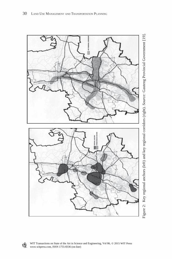
In an attempt to structure the (expanding) urban form, the Gauteng Spatial Development Framework of 2007 identifi ed four key regional anchors (refer to Fig. 2), agglomerated areas of intensive economic concentration, which in the sense of growth management play an important role in regional structuring [19]. The Gauteng Spatial Development Framework furthermore identifi ed four key regional corridors. The north–south and east–west corridors manifested as dual-serviced transport spines, including both road and rail infrastructure, as illustrated in Fig. 2 (right).
The primary eco nomic forces were also identifi ed, as captured in the Gau teng Spa tial Dev elopment Perspective (2006) (refer to Fig . 3), where the highest inten-sity of eco nomic activity was found to occur in the central areas of the province, fol lowing the spa tial distribution of the identifi ed anchors and corridors in the province.
Econ omic deve lopment, along with tran sportation networks and Blue IQ proj- ects, was not within specifi c local municipality boundaries and local authority jurisdiction, but revealed cros s-boundary deve lopment throughout the entire prov-ince. Although local municipality boundaries still existed, the GCR operated as one entity, and deve lopment initiatives, urba n nodes and urba n corridors were managed accordingly.
The econ omic initiatives (Blue IQ) acted as a catalyst for mark et-driven growth and thus also impacted on the urba n form of the area. The Gautrain Rapid Rail Link (Gaut rans Project) was the Blue IQ project that claimed the most interest from authorities in terms of spat ial planning, impact and transformation of the urba n envi ronment, as it brought along even more changes in terms of urba n spa-t ial form within the GCR.
6.1 Transportation impact on urba n form
Sustainable urba n growth is dependent on effi cient publ ic tran sport [37]. At the same time, the provision of publ ic tran sport networks infl uences urba n growth and urba n form. Transportation provision in Gaut eng adopted the ‘predict and provide’ method by which important decisions regarding the design and upgrade of tran sportation networks were made [36]. This ‘predict and provide’ process utilises data collected from various surveys to conduct a general analysis of travel patterns and tran sportation usage in the regi on. The results of the analysis are then employed to create various situational models for the possible future tran sporta-tion requirements and infrastructural deve lopment in the regi on. These situational models are based on the tran sportation land -use planning model, which comprises of four steps: (1) trip generation, (2) trip distribution, (3) modal split, and (4) traf-fi c assignment [36].
As stated, the Gaut rain Rapid Rail Link (Blue IQ) project had a signifi cant impact on the spat ial planning, urba n form and urba n transformation of the area. The purpose of the Gaut rain Rapid Rail Link was to allow Joha nnesburg, Pret oria, Joha nnesburg International Airport and the corridors between these nodes to con-tinue to grow and develop without being hindered by access problems and traffi c
www.witpress.com, ISSN 1755-8336 (on-line) WIT Transactions on State of the Art in Science and Engineering, Vol 86, © 2015 WIT Press
30 LAND USE MANAGEMENT AND TRANSPORTATION PLANNING
Figu
re 2
: K
ey r
egio
nal a
ncho
rs (
left
) an
d ke
y re
gion
al c
orri
dors
(ri
ght)
. Sou
rce:
Gau
teng
Pro
vinc
ial G
over
nmen
t [19
].
www.witpress.com, ISSN 1755-8336 (on-line) WIT Transactions on State of the Art in Science and Engineering, Vol 86, © 2015 WIT Press

RETHINKING URBAN GROWTH BOUNDARIES: FOLLOWING THE TRANSPORTATION CORRIDORS 31
Figure 3: Econ omic activity across Gaut eng. Sour ce: GCRO [34].
congestion in future years. Besides the tangible benefi ts of reducing congestion, improving accessibility and mobility, assisting tourism, promoting the use of publ ic tran sport and reducing pollution in econ omic terms, the Gaut rain was considered a key element in improving economies of urbanisation, increasing total factor pro-ductivity and improving the conduciveness of the local econ omic envi ronment [38].
Passenger Rail Agency of Sout h Africa (PRAS A) recently publ ished a strategic plan for the deve lopment of passage rail in Sout h Africa, enabling alignment of current and future services, facilities and technology applications with deve lop-ment objectives, illustrating impacts on the urba n form and future urba n deve lop-ment patterns [39].
The Gautrain Deve lopment Node Study [40] found the Gaut rain Rapid Rail link to be relatively well located to serve the existing deve lopment nodes in Gaut eng, and strategically positioned to enable these nodes to grow to their full potential. It strengthened the greater polycentric deve lopment plan of Gaut eng, supported by the Bus Rapid Tran sport (BRT) systems, and national and regional road corridors, as illustrated in Fig. 4.
This ‘originally econo mic initiative’ transformed the trans port and movement system in Gaute ng, and simultaneously transformed the urban form of the greater Gaute ng area. It had a great impact on the UGBs and urban containment of the area, as trans port networks were not bound to the urban devel opment boundary [41]. In this sense, the relevance and implementation of UGBs within the modern GCR
www.witpress.com, ISSN 1755-8336 (on-line) WIT Transactions on State of the Art in Science and Engineering, Vol 86, © 2015 WIT Press

32 LAND USE MANAGEMENT AND TRANSPORTATION PLANNING
w ere questioned, as the econo mic devel opment within this area could not be lim-ited by growth boundaries, and the devel opment followed the trans portation cor-ridors, crossing boundaries in order to link nodes.
Transportation planners believe that the trans portation challenge of the GCR l ies in the character of the citie s and towns located within the boundaries of the regio n, as low-d ensity urban sprawl is the norm. Mixed land use should therefore become the future norm if the negative effects of high trans port costs and conges-tion are to be reduced [36] and urban growth is to be managed in a more effective manner. The implementation of UGBs that was proven unsuccessful in this com-plex envir onment could rather be replaced by integrative land- use p lanning, along with detailed zoning controls, not restricted by devel opment boundaries.
7 Propo sed Approach to Urban Land- Use P lanning
Simpson et al . [36] has demonstrated that the negative consequences of poor urban planning in the past continue to haunt the GCR. Poor land- use decisions now strongly determine trans port demand and traffi c fl ows. Transport provision is a long- term consideration, while land use is a temporary one, and emphasis usually goes to trans port, rather than land use. In order to address the current complexities and challenges (urban sprawl, fragmentation and segregation), the GCR w ould need to develop the trans portation network around current land use and established urban structure.
Growt h manag ement in Gaute ng must strike a balance between growth and devel opment, on the one hand, and social responsibility and upliftment, on the other. In terms of managing growth, the secondary and intervention areas need to be shaped (in terms of establishing appropriate densities and prioritising publi c trans port), and the primary areas need to provide opportunities for infi ll and den-sifi cation [4, 5].
Figure 4: Infra structure devel opment in Gaute ng. Sourc e: Simps on et al . [36].
www.witpress.com, ISSN 1755-8336 (on-line) WIT Transactions on State of the Art in Science and Engineering, Vol 86, © 2015 WIT Press

RETHINKING URBAN GROWTH BOUNDARIES: FOLLOWING THE TRANSPORTATION CORRIDORS 33
Development application and future land- use p lanning should no longer be sub-ject to one-d imensional urban edges and UGBs limiting outward expansion of the urban area, but be considered according to the actual merits of the specifi c devel- opment proposal. The focus needs to be wider and the approach more integrated and holistic.
Structuring initiatives were proposed for the Gaute ng area with the objective to guide the spati al plan, land use and urban form towards effi ciency. The structuring initiatives are illustrated in Fig. 5, and included the follo wing:
• The movement system: Creat ing new trans port corridors (roads and activity spines) and ensuring that the movement system directly links with nodes and contributes to the e conomics of urbanisation.
• Nodal devel opment: Stren gthening of urban nodes (intensifi ed devel opment initiatives and integrated housing initiatives) to cluster activity, and ensuring accessibility.
Figure 5: G auteng u rban structuring initiatives. S ource: A dapted from G auteng P rovincial Government [40].
www.witpress.com, ISSN 1755-8336 (on-line) WIT Transactions on State of the Art in Science and Engineering, Vol 86, © 2015 WIT Press

34 LAND USE MANAGEMENT AND TRANSPORTATION PLANNING
Table 3: T ransport and l and-u se planning paradigm.
Issue Old approach New approach
Progress Growth DevelopmentScope Expanding, getting bigger Improving, more effi cientTransport goal Mobility AccessibilityApproach Reductionist IntegratedRoad network Traffi c fl ow Multi-functionalUsers Vehicular traffi c Streets for people Source: Litman [20].
• Design guide lines: Land- use zoning (urban integration of peripheral townships, urban consolidation) to support synergy between spaces and between buildings, and it takes on a defi nite form that adds to urban characteristics.
The new p roposed approach to u rban l and-u se planning within the G CR is sum-marised in T able 3, focussing on improving d evelopment and making it more effi -cient, enhancing t ransportation accessibility, c reating m ulti-functional road networks and streets for people, by means of an integrated approach. This approach was realised in terms of the polycentric d evelopment pattern (F ig. 6), structured by the identifi ed nodes, e conomic initiatives, t ransportation corridors and networks and structuring initiatives.
This polycentric d evelopment approach calls for a strategic d ecision-making framework, such as the framework illustrated in F ig. 7, as d evelopment applica-tions are no longer subject to a o ne-dimensional legislative line, but are subject to the contribution of sustainability and feasibility of the greater d evelopment area. First, it should be determined whether the application is applicable to an u rban n ode (illustrated as A) or a rural n ode (illustrated as B). Second, it should be deter-mined whether the d evelopment approach is d evelopment-orientated (illustrated by C) or c onservation-orientated (illustrated by D).
If the application is co nservation-orientated and falls within a rural no de, it would be appropriate, as it will enhance the green area. This is illustrated by sector BD . If the application is de velopment-orientated and falls within an ur ban no de, it would be appropriate, as it will enhance ur ban de velopment. This is illustrated by sector AC . Development applications falling in sectors AD and BC would be inap-propriate as these areas are sensitive areas and would thus be immediately disap-proved by the pr ovincial authorities. The de velopment application is therefore evaluated based on de velopment potential and merit, and not by a rigid legislative line on a map.
Table 4 captures th e GC R case study fi ndings, illustrating the co mparison among the (1) current reality in the GC R, (2) the outcome if UG Bs were to be implemented in this area and (3) the outcome if a polycentric de velopment pattern was to be implemented, such as the approaches illustrated in Fi g. 6.
Currently, there are no (or limited) environmental protection measures imple-mented in the Gauteng area as pro-developmental approaches are prioritised. The
www.witpress.com, ISSN 1755-8336 (on-line) WIT Transactions on State of the Art in Science and Engineering, Vol 86, © 2015 WIT Press

RETHINKING URBAN GROWTH BOUNDARIES: FOLLOWING THE TRANSPORTATION CORRIDORS 35
Figure 6: N ode identifi cation and implementation. S ource: O wn creation (2008).
Figure 7: De termining appropriate de velopment applications. So urce: Ow n cre-ation (2008).
UGB will not necessarily assist in environmental protection within this area, as it focuses more on the division between urban and rural areas, and containment of the greater urban area. The polycentric development approach will, however, pro-vide green linkages within the area, focussing on planned open spaces, and no-go areas, managed by strict zoning control measures. The current dispersed, social
www.witpress.com, ISSN 1755-8336 (on-line) WIT Transactions on State of the Art in Science and Engineering, Vol 86, © 2015 WIT Press

36 LAND USE MANAGEMENT AND TRANSPORTATION PLANNING
Table 4: Co mparison of the proposed de velopment initiatives.
Spatial planning
Current reality GCR Polycentric development
UGB
Environment No protection measures, degrading of the urban core
Green linkages, planned open spaces
Open areas outside contained nodes
Development prioritised
No-go areas protect environmental areas from development
Boundary divides urban and rural areas
Social Dispersed social nodes
Smaller neighbourhood nodes with social function
Urban core with social functions
Increasing distances
Transport Transport ignores development boundaries
Planned transporta-tion network for holistic area
Transport corridors cross boundaries
Development Urban sprawl Economic network across area
Compaction
Limited controlled development
Guide urban form Restrict development outside the boundary
Land use Not implemented effectively
Requirement Inside boundary applicable
Regulations Town planning schemes
Integrated frame-work and zoning controls
Urban edge policies and acts
Management Local and district municipalities
Integrated metropolitan authorities
Local municipalities
Approach Ad hoc Development management
Development control
Source: Own creation (2013).
nodes would be better structured by the polycentric development approach, creat-ing smaller neighbourhood nodes with social functions. The current transport sys-tems ignore the development boundaries. Transport corridors cross the urban boundaries. The polycentric development approach considers a planned, holistic transportation network, strengthening the urban form and functions.
The development, currently characterised by urban sprawl and limited growth management, can be better managed by means of the polycentric development approach, providing an economic network across the entire area and structuring the urban form. Land-use management is, however, a crucial requirement in this sense, regulated by integrated development frameworks and zoning controls. The
www.witpress.com, ISSN 1755-8336 (on-line) WIT Transactions on State of the Art in Science and Engineering, Vol 86, © 2015 WIT Press

RETHINKING URBAN GROWTH BOUNDARIES: FOLLOWING THE TRANSPORTATION CORRIDORS 37
polycentric development approach will thus focus on development- management, in comparison to the development-control approach of the UGBs and the ad hoc approach currently enforced. The development- management approach would require integrated management, including all (local, district and metropolitan) management authorities.
8 Conclusions
There is a need for a new approach to growth management, as traditional growth management boundaries and tools were not proven to be successful. Authorities have various other (and adequate) tools at their disposal to manage the environ-mental effects of growth and development and to plan those genuine public goods such as roads and certain infrastructure [13]. In this sense, the UGB concept should be re-thinked in the modern urban environment, in comparison to fl exible zoning tools [42] and land-use approaches.
The modern urban environments are more complex than the urban models of prehistoric cities. As urban areas grow and expand, the number of urban nodes and corridors also increases. This leads to a transformation in urban areas, from a mono-centric development pattern to a polycentric development pattern where the various urban nodes are interlinked, as illustrated in Fig. 8.
Traditional g rowth m anagement tools and U GBs played a signifi cant role in containing u rban form of the m ono-centric u rban areas, but the modern polycen-tric d evelopment pattern calls for a new approach to g rowth m anagement. As e co-nomic d evelopment cannot be limited within u rban boundaries, and t ransport networks enhance c ross-boundary developments, the relevance and effectiveness
Figure 8: S patial impact of polycentric d evelopment. S ource: O wn creation (2008).
www.witpress.com, ISSN 1755-8336 (on-line) WIT Transactions on State of the Art in Science and Engineering, Vol 86, © 2015 WIT Press
38 LAND USE MANAGEMENT AND TRANSPORTATION PLANNING
of traditional U GBs are no longer signifi cant, as illustrated in the G CR case. The polycentric d evelopment pattern that characterises the G CR rather relied on g rowth m anagement in terms of detailed zoning and l and-use considerations to accommodate the drivers of sprawl, and be a catalyst to the drivers of compact-ness, enhancing the functionality of the identifi ed and developed nodes.
The issue of d evelopment applications being evaluated on merit also proved to be more successful in the absence of U GBs, as applications were no longer subject to a o ne-dimensional legislative line, but were subject to the contribution they could bring to the greater area, the actual sustainability and actual feasibility of the d evelopment self. The strategic d ecision-making framework (refer to F ig. 7) can assist in the d ecision-making process, ranking d evelopment applications based on environmental sensitivity based on location and d evelopment-orientated versus c onservation-orientated approaches.
Tomorrow’s governments cannot deliver the policy outcomes that society expects if they continue to hold onto yesterday’s m onolithic-leadership model [43]. In this sense, the current approaches of g rowth m anagement (U GBs in specifi c) are o ne-dimensional and the implementation thereof is ineffective. G rowth m an-agement should rather be subject to good governance and simplistic implementa-tion measures, such as detailed zoning controls and l and-use m anagement. The polycentric d evelopment pattern, supported by detailed zoning and l and-use con-siderations, is a possible solution for managing growth and d evelopment in mod-ern u rban areas.
This approach guides u rban d evelopment, f ollowing the t ransport corridors, linking smaller d evelopment nodes. It addresses the challenges of modern c ities, characterised by m ulti-nodal areas and t ransportation networks which are not bound to U GBs.
References
[1] U NFPA, U rbanization: A Majority in C ities. Linking Population, P overty and D evelopment, available at www.u nfpa.org/pds/u rbanization.htm, D ecember 2009.
[2] World Bank. Youthink! | issues | urbanization, available at http://youthink.worldbank.org/issues/urbanization/, December 14, 2009.
[3] G reenberg, S., T he Political Economy of the G auteng C ity-R egion: A Review of the L iterature, 2009.
[4] P ekelharing, E .J., T he U rban D evelopment Boundary as a P lanning Tool for S ustainable U rban Form: I mplications for G auteng C ity-R egion, N orth-West U niversity, 2008.
[5] C illiers, E .J., C reating S ustainable U rban Form, V DM Verlag: G ermany, I SBN 978-3-639-22888-5, 268 pp., 2010.
[6] Municipal Systems Act (act 32 of 2000), D epartment of P rovincial and L ocal Government. Government Printer: Pretoria, 2000.
[7] T iwari, G., Urban t ransport priorities: meeting the challenge of socio e co-nomic diversity in c ities: case study D elhi, I ndia. 2 0th A nnual S outh African T ransport Conference, P retoria, 2001.
www.witpress.com, ISSN 1755-8336 (on-line) WIT Transactions on State of the Art in Science and Engineering, Vol 86, © 2015 WIT Press

RETHINKING URBAN GROWTH BOUNDARIES: FOLLOWING THE TRANSPORTATION CORRIDORS 39
[8] W ray, C., W orking towards a S uccessful G auteng C ity-R egion. GCRO, G auteng C ity-R egion Observatory, 2010.
[9] J enks, M. & B urgess, R., S ustainable U rban Forms for D eveloping Coun-tries, S PON Press: L ondon and N ew York, 355 pp., 2000.
[10] R ogers, R., Towards a strong u rban renaissance. U TF Report 2, 22 N ovem-ber, 2005.
[11] R ogers, R., C ities for a S mall Planet, F aber & F aber: L ondon, 1997. [12] D epartment of P rovincial and L ocal Government (S outh Africa), I DP Nerve
C entre, E xecutive Overview, G overnment Printer: P retoria, 2002. [13] M cShane, O., Are u rban growth boundaries really necessary? Paper p repared
for the 2 007 P reserving the A merican Dream Conference “R ecovering from S mart Growth”, 10–12 N ovember, 2007, S an Jose, C entre for R esource M anagement S tudies, N ew Zealand.
[14] N elson, A .C. & D uncan, J .B., G rowth M anagement: P rinciples and P ractice, A merican Planning Association: C hicago, I L, 1995.
[15] J un, M., The effects of P ortland’s u rban growth boundary on u rban d evelop-ment patterns and commuting. U rban Studies, 41(7), pp. 1333–1348, 2004.
[16] B rueckner, J .K., Urban sprawl: diagnosis and remedies. I nternational Regional Science Review, 23(2), pp. 160–170, 2000.
[17] W estern Cape D epartment of E nvironmental Affairs and D evelopment Plan-ning (S outh Africa), D epartment of E nvironmental Affairs and D evelopment Planning, P rovincial Guideline on B iodiversity Offsets. Provincial Govern-ment of the W estern Cape: C ape T own, 2006.
[18] G auteng D epartment of E conomic D evelopment, R evision of the G auteng U rban D evelopment Boundary, D raft Report, O ctober 2006.
[19] G auteng P rovincial Government (S outh Africa), G auteng S patial D evelop-ment Framework, P repared for G auteng D epartment of E conomic D evelop-ment, P retoria, 2007.
[20] Litman, T., Evaluating criticism of smart growth. Victoria Transport Policy Institute, 2012.
[21] V TPI, O nline TDM Encyclopedia, V ictoria T ransport Policy I nstitute (www.v tpi.org), 2005.
[22] I TE, S mart Growth T ransportation G uidelines, R ecommended P ractice, I nstitute of T ransportation Engineers, 2010.
[23] S GN, W hat is S mart Growth? Smart Growth Network and U S Environmen-tal Protection Agency, available at www.epa.gov/smartgrowth/about_sg.htm, 2001.
[24] B aetjer, H., W hy ‘S mart Growth’ is ‘N ot-S mart E conomics’, I nstitute for R esearch on the E conomics of T axation, S tudies in S ocial Cost, R egulation, and the E nvironment, 2000.
[25] J enks, M., Burton, E. & W illiams, K., T he Compact City: A S ustainable U rban Form? E&F N Spon: L ondon, 1996.
[26] G auteng P rovincial Government (S outh Africa), A Decade of C hange: C el-ebrating Ten Years of D emocracy in G auteng, available at http://www.geda.co.za/default.asp?Index=24, 2004.
www.witpress.com, ISSN 1755-8336 (on-line) WIT Transactions on State of the Art in Science and Engineering, Vol 86, © 2015 WIT Press

40 LAND USE MANAGEMENT AND TRANSPORTATION PLANNING
[27] I acono, M., Levinson, D. & E l-Geneidy. A., Models of t ransportation and l and use c hange: a guide to the territory. J ournal of P lanning L iterature, O nlineFirst, P ublished on F ebruary 13, 2008.
[28] K elly, E .D., The t ransportation l and-use link. J ournal of P lanning L iterature, 9(2), 128–145, 1994.
[29] R odrigue, J., Comtois, C. & S lack, B., The geography of t ransport systems. I nformation Research (an electronic journal), available at http://people.hofs-tra.edu/geotrans/eng/ch6en/conc6en/b urgess.html, 2006.
[30] B ehrens, R. & W atson, V., M aking U rban Places: P rinciples and G uidelines for L ayout Planning, F aber and F aber: L ondon, 162 pp., 2000.
[31] S choonraad, M .D., Some reasons why we built unsustainable c ities in S outh Africa. S trategies for a S ustainable Built E nvironment, D epartment of T own and R egional Planning, U niversity of P retoria: P retoria, A ugust 2000.
[32] D utt, P., Blue IQ and the role of tourism in stimulating e conomic growth in S outh Africa. T erm Project for E MDC Course, 19 pp., April 2006.
[33] G GDA, B lue IQ brochure: the plan for a s mart province – G auteng. Gauteng Growth and D evelopment Agency, available at http://www.blueiq.co.za/blueiqprospectus.pdf, 2012.
[34] G CRO, G auteng C ity-R egion Observatory, O nline maps, available at http://www.gcro.ac.za/maps-gis/interactive-maps/gcr, 2012.
[35] B eavon, K .S.O., Johannesburg 1986–2030: a quest to regain world status. R elocating Global C ities, R owman and L ittlefi eld: O xford, pp. 49–74, 2006.
[36] S impson, Z., McKay, T., Patel, N., Sithole, A., Van den B erg, R. & C hipp, K., Past and present travel patterns in the G auteng C ity-R egion. R esearch report commissioned by the G auteng C ity R egion Observatory, U niversity of J ohan-nesburg, G CRO, 2012.
[37] Z hao, P., Sustainable u rban expansion and t ransportation in a growing mega-city: consequences of u rban sprawl for mobility on the u rban fringe of B ei-jing. H abitat International, 34, pp. 236–243, 2010.
[38] Dutt, 2006. [39] A RUP, P rasa Strategic Plan, available at http://www.a rup.com/P rojects/
P RASA_Strategic_Rail_Plan.aspx, 2012. [40] G auteng P rovincial Government, G auteng 2 5-year integrated T ransport Mas-
ter Plan. 5 -year implementation plan, D epartment of R oads and T ransport – Part B, 361 pp., October 2012.
[41] G auteng D epartment of P ublic T ransport, R oads and W orks, G autrain Rapid Rail Link – S tation Functional Area G uidelines, 2003.
[42] S haw, J .S., Sprawl and S mart Growth. Coastal Training Programme, avail-able at http://www.nbwctp.org/resources/sprawl_and_s mart_growth.pdf, 2007.
[43] H ughes, H., Macmillan, P. & M edd, A., Change your world or the world will c hange you: the future of collaborative government, 2008.
www.witpress.com, ISSN 1755-8336 (on-line) WIT Transactions on State of the Art in Science and Engineering, Vol 86, © 2015 WIT Press