Chapter 2 Plate Tectonics: A Unifying...
38
Plate Tectonics: A Unifying Theory Chapter 2 11487_02_ch02_p032-069.qxd 2/16/06 9:31 AM Page 32
Transcript of Chapter 2 Plate Tectonics: A Unifying...

Plate Tectonics: A Unifying Theory
Chapter 2
11487_02_ch02_p032-069.qxd 2/16/06 9:31 AM Page 32
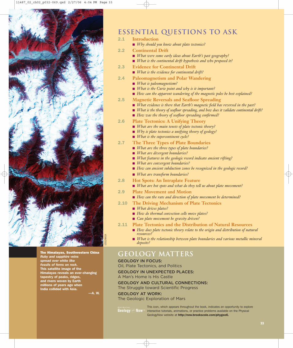
Essential Questions to Ask2.1 Introduction
� Why should you know about plate tectonics? 2.2 Continental Drift
� What were some early ideas about Earth’s past geography? � What is the continental drift hypothesis and who proposed it?
2.3 Evidence for Continental Drift� What is the evidence for continental drift?
2.4 Paleomagnetism and Polar Wandering� What is paleomagnetism?� What is the Curie point and why is it important?� How can the apparent wandering of the magnetic poles be best explained?
2.5 Magnetic Reversals and Seafloor Spreading� What evidence is there that Earth’s magnetic field has reversed in the past?� What is the theory of seafloor spreading, and how does it validate continental drift?� How was the theory of seafloor spreading confirmed?
2.6 Plate Tectonics: A Unifying Theory� What are the main tenets of plate tectonic theory?� Why is plate tectonics a unifying theory of geology?� What is the supercontinent cycle?
2.7 The Three Types of Plate Boundaries� What are the three types of plate boundaries?� What are divergent boundaries?� What features in the geologic record indicate ancient rifting?� What are convergent boundaries?� How can ancient subduction zones be recognized in the geologic record?
� What are transform boundaries?2.8 Hot Spots: An Intraplate Feature
� What are hot spots and what do they tell us about plate movement? 2.9 Plate Movement and Motion
� How can the rate and direction of plate movement be determined? 2.10 The Driving Mechanism of Plate Tectonics
� What drives plates? � How do thermal convection cells move plates?� Can plate movement be gravity driven?
2.11 Plate Tectonics and the Distribution of Natural Resources� How does plate tectonic theory relate to the origin and distribution of natural
resources?� What is the relationship between plate boundaries and various metallic mineral
deposits?
The Himalayas, Southwestern ChinaRuby and sapphire veins spread over white like fossils of ferns on rock.This satellite image of the Himalayas reveals an ever-changing tapestry of peaks, ridges, and rivers woven by Earth millions of years ago when India collided with Asia.
—A. W.
33
This icon, which appears throughout the book, indicates an opportunity to exploreinteractive tutorials, animations, or practice problems available on the PhysicalGeologyNow website at http://now.brookscole.com/phygeo6.
Geology MattersGEOLOGY IN FOCUS:Oil, Plate Tectonics, and Politics
GEOLOGY IN UNEXPECTED PLACES:A Man’s Home Is His Castle
GEOLOGY AND CULTURAL CONNECTIONS:The Struggle toward Scientific Progress
GEOLOGY AT WORK:The Geologic Exploration of Mars
USGS
/NAS
A
11487_02_ch02_p032-069.qxd 2/27/06 4:04 PM Page 33
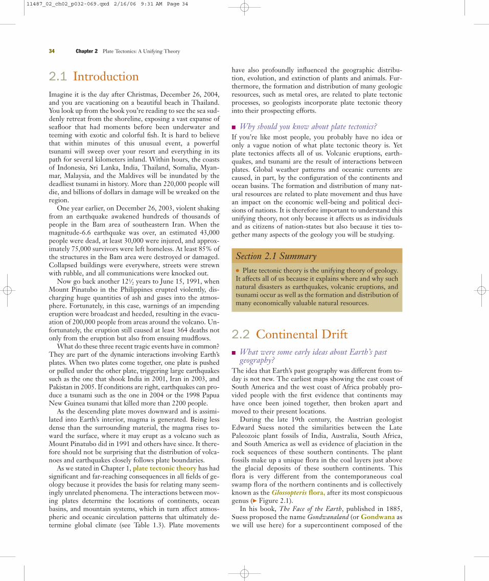
2.1 IntroductionImagine it is the day after Christmas, December 26, 2004,and you are vacationing on a beautiful beach in Thailand.You look up from the book you’re reading to see the sea sud-denly retreat from the shoreline, exposing a vast expanse ofseafloor that had moments before been underwater andteeming with exotic and colorful fish. It is hard to believethat within minutes of this unusual event, a powerfultsunami will sweep over your resort and everything in itspath for several kilometers inland. Within hours, the coastsof Indonesia, Sri Lanka, India, Thailand, Somalia, Myan-mar, Malaysia, and the Maldives will be inundated by thedeadliest tsunami in history. More than 220,000 people willdie, and billions of dollars in damage will be wreaked on theregion.
One year earlier, on December 26, 2003, violent shakingfrom an earthquake awakened hundreds of thousands ofpeople in the Bam area of southeastern Iran. When themagnitude-6.6 earthquake was over, an estimated 43,000people were dead, at least 30,000 were injured, and approx-imately 75,000 survivors were left homeless. At least 85% ofthe structures in the Bam area were destroyed or damaged.Collapsed buildings were everywhere, streets were strewnwith rubble, and all communications were knocked out.
Now go back another 121⁄2 years to June 15, 1991, whenMount Pinatubo in the Philippines erupted violently, dis-charging huge quantities of ash and gases into the atmos-phere. Fortunately, in this case, warnings of an impendingeruption were broadcast and heeded, resulting in the evacu-ation of 200,000 people from areas around the volcano. Un-fortunately, the eruption still caused at least 364 deaths notonly from the eruption but also from ensuing mudflows.
What do these three recent tragic events have in common?They are part of the dynamic interactions involving Earth’splates. When two plates come together, one plate is pushedor pulled under the other plate, triggering large earthquakessuch as the one that shook India in 2001, Iran in 2003, andPakistan in 2005. If conditions are right, earthquakes can pro-duce a tsunami such as the one in 2004 or the 1998 PapuaNew Guinea tsunami that killed more than 2200 people.
As the descending plate moves downward and is assimi-lated into Earth’s interior, magma is generated. Being lessdense than the surrounding material, the magma rises to-ward the surface, where it may erupt as a volcano such asMount Pinatubo did in 1991 and others have since. It there-fore should not be surprising that the distribution of volca-noes and earthquakes closely follows plate boundaries.
As we stated in Chapter 1, plate tectonic theory has hadsignificant and far-reaching consequences in all fields of ge-ology because it provides the basis for relating many seem-ingly unrelated phenomena. The interactions between mov-ing plates determine the locations of continents, oceanbasins, and mountain systems, which in turn affect atmos-pheric and oceanic circulation patterns that ultimately de-termine global climate (see Table 1.3). Plate movements
have also profoundly influenced the geographic distribu-tion, evolution, and extinction of plants and animals. Fur-thermore, the formation and distribution of many geologicresources, such as metal ores, are related to plate tectonicprocesses, so geologists incorporate plate tectonic theoryinto their prospecting efforts.
� Why should you know about plate tectonics?If you’re like most people, you probably have no idea oronly a vague notion of what plate tectonic theory is. Yetplate tectonics affects all of us. Volcanic eruptions, earth-quakes, and tsunami are the result of interactions betweenplates. Global weather patterns and oceanic currents arecaused, in part, by the configuration of the continents andocean basins. The formation and distribution of many nat-ural resources are related to plate movement and thus havean impact on the economic well-being and political deci-sions of nations. It is therefore important to understand thisunifying theory, not only because it affects us as individualsand as citizens of nation-states but also because it ties to-gether many aspects of the geology you will be studying.
Section 2.1 Summary● Plate tectonic theory is the unifying theory of geology.It affects all of us because it explains where and why suchnatural disasters as earthquakes, volcanic eruptions, andtsunami occur as well as the formation and distribution ofmany economically valuable natural resources.
2.2 Continental Drift� What were some early ideas about Earth’s past
geography?The idea that Earth’s past geography was different from to-day is not new. The earliest maps showing the east coast ofSouth America and the west coast of Africa probably pro-vided people with the first evidence that continents mayhave once been joined together, then broken apart andmoved to their present locations.
During the late 19th century, the Austrian geologistEdward Suess noted the similarities between the LatePaleozoic plant fossils of India, Australia, South Africa,and South America as well as evidence of glaciation in therock sequences of these southern continents. The plantfossils make up a unique flora in the coal layers just abovethe glacial deposits of these southern continents. Thisflora is very different from the contemporaneous coalswamp flora of the northern continents and is collectivelyknown as the Glossopteris flora, after its most conspicuousgenus (� Figure 2.1).
In his book, The Face of the Earth, published in 1885,Suess proposed the name Gondwanaland (or Gondwana aswe will use here) for a supercontinent composed of the
34 Chapter 2 Plate Tectonics: A Unifying Theory
11487_02_ch02_p032-069.qxd 2/16/06 9:31 AM Page 34

aforementioned southern continents. Abundant fossils ofthe Glossopteris flora are found in coal beds in Gondwana,a province in India. Suess thought these southern conti-nents were at one time connected by land bridges overwhich plants and animals migrated. Thus, in his view, thesimilarities of fossils on these continents were due to theappearance and disappearance of the connecting landbridges.
The American geologist Frank Taylor published a pam-phlet in 1910 presenting his own theory of continentaldrift. He explained the formation of mountain ranges as aresult of the lateral movement of continents. He also envi-sioned the present-day continents as parts of larger polar
continents that eventually broke apart and migrated towardthe equator after Earth’s rotation was supposedly slowed by gigantic tidal forces. According to Taylor, these tidalforces were generated when Earth captured the Moonabout 100 million years ago.
Although we now know that Taylor’s mechanism is in-correct, one of his most significant contributions was hissuggestion that the Mid-Atlantic Ridge, discovered by the1872–1876 British HMS Challenger expeditions, mightmark the site along which an ancient continent broke apartto form the present-day Atlantic Ocean.
� What is the continental drift hypothesis and who proposed it?
Alfred Wegener, a German meteorologist (� Figure 2.2), isgenerally credited with developing the hypothesis of conti-nental drift. In his monumental book, The Origin of Conti-nents and Oceans (first published in 1915), Wegener pro-posed that all landmasses were originally united in a singlesupercontinent that he named Pangaea, from the Greekmeaning “all land.” Wegener portrayed his grand concept ofcontinental movement in a series of maps showing thebreakup of Pangaea and the movement of the various conti-nents to their present-day locations. Wegener amassed atremendous amount of geologic, paleontologic, and clima-tologic evidence in support of continental drift, but the ini-tial reaction of scientists to his then-heretical ideas can bestbe described as mixed.
Opposition to Wegener’s ideas became particularly wide-spread in North America after 1928, when the AmericanAssociation of Petroleum Geologists held an internationalsymposium to review the hypothesis of continental drift.
After each side had presented itsarguments, the opponents of con-tinental drift were clearly in themajority, even though the evidencein support of continental drift, mostof which came from the SouthernHemisphere, was impressive and dif-ficult to refute. The main problemwith the hypothesis was its lack of amechanism to explain how conti-nents, composed of granitic rocks,could seemingly move through thedenser basaltic oceanic crust.
Nevertheless, the eminent SouthAfrican geologist Alexander du Toitfurther developed Wegener’s argu-ments and gathered more geologicand paleontologic evidence in sup-port of continental drift. In 1937 duToit published Our Wandering Conti-nents, in which he contrasted theglacial deposits of Gondwana withcoal deposits of the same age found in the continents of the NorthernHemisphere. To resolve this apparent
2.2 Continental Drift 35
� Figure 2.1 Fossil Glossopteris Leaves Plant fossils, such asthese Glossopteris leaves from the Upper Permian Dunedoo Formationin Australia, are found on all five Gondwana continents. The presenceof these fossil plants on continents with widely varying climates today is evidence that the continents were at one time connected.The distribution of the plants at that time was in the same climaticlatitudinal belt.
Cour
tesy
of P
atric
ia G
. Gen
sel,
Univ
ersi
ty o
f Nor
th C
arol
ina
� Figure 2.2 Alfred Wegener Alfred Wegener, a German meteorologist, proposed thecontinental drift hypothesis in 1912 based on a tremendous amount of geologic, paleontologic,and climatologic evidence. He is shown here waiting out the Arctic winter in an expedition hut inGreenland.
Bild
arch
iv P
reus
sisc
her K
ulte
rbes
tiz
11487_02_ch02_p032-069.qxd 2/16/06 9:31 AM Page 35

climatologic paradox, du Toit moved the Gondwana conti-nents to the South Pole and brought the northern continentstogether such that the coal deposits were located at the equa-tor. He named this northern landmass Laurasia. It consistedof present-day North America, Greenland, Europe, and Asia(except for India).
Despite what seemed to be overwhelming evidence, mostgeologists still refused to accept the idea that the continentsmoved. Not until the 1960s, when oceanographic researchprovided convincing evidence that the continents had oncebeen joined together and subsequently separated, did the hy-pothesis of continental drift finally become widely accepted.
Section 2.2 Summary● The idea that continents have moved in the past is notnew and probably goes back to the first maps, in whichone could see that the east coast of South America lookslike it fits into the west coast of Africa.
● The continental drift hypothesis was first articulatedby Alfred Wegener in 1912. He proposed that a singlesupercontinent, Pangaea, consisting of a northern land-mass (later named Laurasia) and a southern landmass(previously named Gondwana), broke apart into whatwould become Earth’s current continents, which thenmoved across Earth’s surface to their present locations.
2.3 Evidence for ContinentalDrift� What is the evidence for continental drift?What, then, was the evidence Wegener, du Toit, and othersused to support the hypothesis of continental drift? It in-cludes the fit of the shorelines of continents, the appearanceof the same rock sequences and mountain ranges of thesame age on continents now widely separated, the matchingof glacial deposits and paleoclimatic zones, and the similar-ities of many extinct plant and animal groups whose fossilremains are found today on widely separated continents.Wegener and his supporters argued that this vast amount ofevidence from a variety of sources surely indicated that thecontinents must have been close together in the past.
Continental FitWegener, like some before him, was impressed by the closeresemblance between the coastlines of continents on oppo-site sides of the Atlantic Ocean, particularly South Americaand Africa. He cited these similarities as partial evidencethat the continents were at one time joined together as a su-percontinent that subsequently split apart. As his criticspointed out, though, the configuration of coastlines resultsfrom erosional and depositional processes and therefore is
continuously being modified. So, even if the continents hadseparated during the Mesozoic Era, as Wegener proposed,it is not likely that the coastlines would fit exactly.
A more realistic approach is to fit the continents togetheralong the continental slope, where erosion would be mini-mal. In 1965 Sir Edward Bullard, an English geophysicist,and two associates showed that the best fit between the con-tinents occurs at a depth of about 2000 m (� Figure 2.3).Since then, other reconstructions using the latest oceanbasin data have confirmed the close fit between continentswhen they are reassembled to form Pangaea.
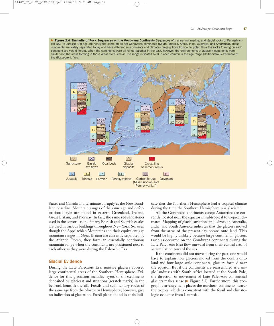
Similarity of Rock Sequences and Mountain RangesIf the continents were at one time joined, then the rocks andmountain ranges of the same age in adjoining locations onthe opposite continents should closely match. Such is thecase for the Gondwana continents (� Figure 2.4). Marine,nonmarine, and glacial rock sequences of Pennsylvanian toJurassic age are almost identical on all five Gondwana conti-nents, strongly indicating that they were joined at one time.
The trends of several major mountain ranges also supportthe hypothesis of continental drift. These mountain rangesseemingly end at the coastline of one continent only to ap-parently continue on another continent across the ocean.The folded Appalachian Mountains of North America, forexample, trend northeastward through the eastern United
36 Chapter 2 Plate Tectonics: A Unifying Theory
NorthAmerica
Greenland
SouthAmerica
Africa
Eurasia
Antarctica
Australia
India
� Figure 2.3 Continental Fit When continents are placed togetherbased on their outlines, the best fit isn’t along their present-daycoastlines, but rather along the continental slope at a depth of about2000 m. Why is this? Because the coastlines are continuously
being modified by erosional and depositional processes, and thus
one would not expect them to be the same today as they were at any
time in the geologic past.
11487_02_ch02_p032-069.qxd 2/16/06 9:31 AM Page 36
States and Canada and terminate abruptly at the Newfound-land coastline. Mountain ranges of the same age and defor-mational style are found in eastern Greenland, Ireland,Great Britain, and Norway. In fact, the same red sandstonesused in the construction of many English and Scottish castlesare used in various buildings throughout New York. So, eventhough the Appalachian Mountains and their equivalent-agemountain ranges in Great Britain are currently separated bythe Atlantic Ocean, they form an essentially continuousmountain range when the continents are positioned next toeach other as they were during the Paleozoic Era.
Glacial EvidenceDuring the Late Paleozoic Era, massive glaciers coveredlarge continental areas of the Southern Hemisphere. Evi-dence for this glaciation includes layers of till (sedimentsdeposited by glaciers) and striations (scratch marks) in thebedrock beneath the till. Fossils and sedimentary rocks ofthe same age from the Northern Hemisphere, however, giveno indication of glaciation. Fossil plants found in coals indi-
cate that the Northern Hemisphere had a tropical climateduring the time the Southern Hemisphere was glaciated.
All the Gondwana continents except Antarctica are cur-rently located near the equator in subtropical to tropical cli-mates. Mapping of glacial striations in bedrock in Australia,India, and South America indicates that the glaciers movedfrom the areas of the present-day oceans onto land. Thiswould be highly unlikely because large continental glaciers(such as occurred on the Gondwana continents during theLate Paleozoic Era) flow outward from their central area ofaccumulation toward the sea.
If the continents did not move during the past, one wouldhave to explain how glaciers moved from the oceans ontoland and how large-scale continental glaciers formed nearthe equator. But if the continents are reassembled as a sin-gle landmass with South Africa located at the South Pole,the direction of movement of Late Paleozoic continentalglaciers makes sense (� Figure 2.5). Furthermore, this geo-graphic arrangement places the northern continents nearerthe tropics, which is consistent with the fossil and climato-logic evidence from Laurasia.
2.3 Evidence for Continental Drift 37
Sandstone Basalt lava flows
Coal beds Glacialdeposits
Crystallinebasement rocks
CCarboniferous
(Mississippian and Pennsylvanian)
UC
Pennsylvanian
P
Permian
TR
Triassic
JR
JurassicD
Devonian
JR
TR
P
C
D
G
JR
TR
PC
G
UCG
JR
TR
P UCG
JR
TR
P
UCG
JR
TR
P
� Figure 2.4 Similarity of Rock Sequences on the Gondwana Continents Sequences of marine, nonmarine, and glacial rocks of Pennsylvan-ian (UC) to Jurassic (JR) age are nearly the same on all five Gondwana continents (South America, Africa, India, Australia, and Antarctica). Thesecontinents are widely separated today and have different environments and climates ranging from tropical to polar. Thus the rocks forming on eachcontinent are very different. When the continents were all joined together in the past, however, the environments of adjacent continents were similar and the rocks forming in those areas were similar. The range indicated by G in each column is the age range (Carboniferous–Permian) of the Glossopteris flora.
11487_02_ch02_p032-069.qxd 2/16/06 9:31 AM Page 37

Fossil EvidenceSome of the most compelling evidence for continental driftcomes from the fossil record. Fossils of the Glossopteris floraare found in equivalent Pennsylvanian- and Permian-agedcoal deposits on all five Gondwana continents. The Glos-sopteris flora is characterized by the seed fern Glossopteris(� Figure 2.1) as well as by many other distinctive and easilyidentifiable plants. Pollen and spores of plants can be dis-persed over great distances by wind, but Glossopteris-typeplants produced seeds that are too large to have been carriedby winds. Even if the seeds had floated across the ocean,they probably would not have remained viable for anylength of time in saltwater.
The present-day climates of South America, Africa, In-dia, Australia, and Antarctica range from tropical to polarand are much too diverse to support the type of plants in theGlossopteris flora. Wegener therefore reasoned that thesecontinents must once have been joined so that these widelyseparated localities were all in the same latitudinal climaticbelt (� Figure 2.6).
The fossil remains of animals also provide strong evi-dence for continental drift. One of the best examples isMesosaurus, a freshwater reptile whose fossils are found inPermian-aged rocks in certain regions of Brazil and SouthAfrica and nowhere else in the world (� Figure 2.6). Becausethe physiologies of freshwater and marine animals are com-
pletely different, it is hard to imagine how a freshwater rep-tile could have swum across the Atlantic Ocean and found afreshwater environment nearly identical to its former habi-tat. Moreover, if Mesosaurus could have swum across theocean, its fossil remains should be widely dispersed. It ismore logical to assume that Mesosaurus lived in lakes in whatare now adjacent areas of South America and Africa butwere then united into a single continent.
Lystrosaurus and Cynognathus are both land-dwelling rep-tiles that lived during the Triassic Period; their fossils arefound only on the present-day continental fragments ofGondwana (� Figure 2.6). Because they are both land ani-mals, they certainly could not have swum across the oceanscurrently separating the Gondwana continents. Therefore,it is logical to assume that the continents must once havebeen connected. Recent discoveries of dinosaur fossils inGondwana continents further solidifies the argument thatthese landmasses were close to each other during the EarlyMesozoic Era.
Notwithstanding all of the empirical evidence presentedby Wegener and later by du Toit and others, most geologistssimply refused to entertain the idea that continents mighthave moved during the past. The geologists were not neces-sarily being obstinate about accepting new ideas; rather, theyfound the evidence for continental drift inadequate and un-convincing. In part, this was because no one could provide a
38 Chapter 2 Plate Tectonics: A Unifying Theory
South America
Australia
Antarctica
SouthPole India
Africa
Cour
tesy
of S
cott
Katz
When the Gondwana continents are placed together so that South Africa is located at the South Pole, the glacial movementsindicated by striations (red arrows) found on rock outcrops oneach continent make sense. In this situation, the glacier (whitearea) is located in a polar climate and has moved radially outwardfrom its thick central area toward its periphery.
a Glacial striations (scratch marks) on an outcrop of Permian-agebedrock exposed at Hallet’s Cove, Australia, indicate the generaldirection of glacial movement more than 200 million years ago. Asa glacier moves over a continent’s surface, it grinds and scratchesthe underlying rock. The scratch marks that are preserved on arock’s surface (glacial striations) thus provide evidence of thedirection (red arrows) the glacier moved at that time.
b
� Geo-focus Figure 2.5 Glacial Evidence Indicating Continental Drift
11487_02_ch02_p032-069.qxd 2/16/06 9:31 AM Page 38

suitable mechanism to explain how continents could moveover Earth’s surface. Interest in continental drift waned untilnew evidence from oceanographic research and studies ofEarth’s magnetic field showed that the present-day oceanbasins were not as old as the continents but were geologicallyyoung features that resulted from the breakup of Pangaea.
Section 2.3 Summary● The evidence for continental drift is impressive. It in-cludes the fact that the continents show a close fit alongthe continental slope at a depth of about 2000 m.
● Furthermore, several major mountain ranges that cur-rently end at the coastline form a continuous range whenthe present-day continents are assembled into a singlelandmass.
● Marine, nonmarine, and glacial rock sequences ofPennsylvanian to Jurassic age are nearly identical on thefive Gondwana continents, suggesting that these conti-nents were joined together during this time interval.
● Glacial deposits and striations indicate that massiveglaciers covered large areas of the Gondwana continentsduring the Late Paleozoic Era. Placing these continentstogether with South Africa located at the South Poleshows that the glaciers moved in a radial pattern from athick central area toward their periphery, as would be ex-pected in such a configuration.
● The distribution of plant and animal fossils also pro-vides strong evidence for continental drift because it ishard to imagine land animals being able to swim acrossthe Atlantic Ocean and the same plants occupying tropi-cal, moderate, and polar environments.
2.3 Evidence for Continental Drift 39
Africa
Cynognathus
Lystrosaurus
Cynognathus
South America
Mesosaurus
Glossopteris
Glossopteris
Glossopteris
Cynognathus
Lystrosaurus
Lystrosaurus
Lystrosaurus
GlossopterisGlossopteris
Australia
India
Antarctica
Mesosaurus
Mesosaurus
Glossopteris
Glossopteris
� Figure 2.6 Fossil Evidence Supporting Continental Drift Some of the plants and animals whose fossils are found today on the widely sepa-rated continents of South America, Africa, India, Australia, and Antarctica. During the Late Paleozoic Era, these continents were joined together toform Gondwana, the southern landmass of Pangaea. Plants of the Glossopteris flora are found on all five continents, which today have widely differ-ent climates, but during the Pennsylvanian and Permian periods, they were all located in the same general climatic belt. Mesosaurus is a freshwaterreptile whose fossils are found only in similar nonmarine Permian-age rocks in Brazil and South Africa. Cynognathus and Lystrosaurus are land rep-tiles that lived during the Early Triassic Period. Fossils of Cynognathus are found in South America and Africa, whereas fossils of Lystrosaurus havebeen recovered from Africa, India, and Antarctica. It is hard to imagine how a freshwater reptile and land-dwelling reptiles could have swum acrossthe wide oceans that presently separate these continents. It is more logical to assume that the continents were at one time connected.
11487_02_ch02_p032-069.qxd 2/16/06 9:31 AM Page 39

2.4 Paleomagnetism and Polar Wandering� What is paleomagnetism?Interest in continental drift revived during the 1950s as aresult of evidence from paleomagnetic studies, a relativelynew discipline at the time. Paleomagnetism is the rema-nent magnetism in ancient rocks recording the directionand intensity of Earth’s magnetic field at the time of therock’s formation. Earth can be thought of as a giant dipolemagnet in which the magnetic poles essentially coincidewith the geographic poles (� Figure 2.7). This arrange-ment means that the strength of the magnetic field is notconstant but varies, being weakest at the equator andstrongest at the poles. Earth’s magnetic field is thought toresult from the different rotation speeds of the outer coreand mantle.
� What is the Curie point and why is it important?When magma cools, the magnetic iron-bearing mineralsalign themselves with Earth’s magnetic field, recording bothits direction and its strength. The temperature at whichiron-bearing minerals gain their magnetization is called theCurie point. As long as the rock is not subsequently heatedabove the Curie point, it will preserve that remanent mag-netism. Thus an ancient lava flow provides a record of the
orientation and strength of Earth’s magnetic field at thetime the lava flow cooled.
� How can the apparent wandering of the magneticpoles be best explained?
As paleomagnetic research progressed during the 1950s,some unexpected results emerged. When geologists mea-sured the paleomagnetism of geologically recent rocks,they found it was generally consistent with Earth’s currentmagnetic field. The paleomagnetism of ancient rocks,though, showed different orientations. For example, pale-omagnetic studies of Silurian lava flows in North Americaindicated that the north magnetic pole was located in thewestern Pacific Ocean at that time, whereas the paleo-magnetic evidence from Permian lava flows pointed to yetanother location in Asia. When plotted on a map, thepaleomagnetic readings of numerous lava flows from allages in North America trace the apparent movement ofthe magnetic pole (called polar wandering) through time (� Figure 2.8). This paleomagnetic evidence from a singlecontinent could be interpreted in three ways: The conti-nent remained fixed and the north magnetic pole moved;the north magnetic pole stood still and the continentmoved; or both the continent and the north magnetic polemoved.
Upon additional analysis, magnetic minerals from Euro-pean Silurian and Permian lava flows pointed to a differentmagnetic pole location from those of the same age in North
40 Chapter 2 Plate Tectonics: A Unifying Theory
Geographic north pole Magnetic north pole
Magneticequator
Geographicequator
Geographicnorth pole
Magneticnorth pole
Lines ofmagnetic force
Dip needle
Geographicequator
Magneticequator
� Figure 2.7 Earth’s Magnetic Field
Earth’s magnetic field has lines of force like those of a bar magnet.a
The strength of the magnetic field changes from the magneticequator to the magnetic poles. This change in strength causes adip needle (a magnetic needle that is balanced on the tip of asupport so that it can freely move vertically) to be parallel toEarth’s surface only at the magnetic equator, where the strength of the magnetic north and south poles are equally balanced. Itsinclination or dip with respect to Earth’s surface increases as itmoves toward the magnetic poles, until it is at 90 degrees orperpendicular to Earth’s surface at the magnetic poles.
b
11487_02_ch02_p032-069.qxd 2/16/06 9:31 AM Page 40

America (� Figure 2.8). Furthermore, analysis of lava flowsfrom all continents indicated that each continent seem-ingly had its own series of magnetic poles. Does this reallymean there were different north magnetic poles for eachcontinent? That would be highly unlikely and difficult toreconcile with the theory accounting for Earth’s magneticfield.
The best explanation for such data is that the magneticpoles have remained near their present locations at the geo-graphic north and south poles and the continents havemoved. When the continental margins are fitted together sothat the paleomagnetic data point to only one magneticpole, we find, just as Wegener did, that the rock sequencesand glacial deposits match and that the fossil evidence isconsistent with the reconstructed paleogeography.
Section 2.4 Summary● Paleomagnetism is the remanent magnetism in ancientrocks recording the direction and intensity of Earth’smagnetic field at the time of the rock’s formation.
● Earth’s magnetic field is not constant. Being strongestat the poles and weakest at the equator, Earth’s magnetic
field is thought to result from the different rotationspeeds of the outer core and mantle. Earth’s magneticpoles closely coincide with its geographic poles.
● The Curie point is the temperature at which iron-bearing minerals gain their magnetism and align them-selves with Earth’s magnetic field.
● Polar wandering is the apparent movement of themagnetic poles through time. The best explanation forsuch apparent movement is that the magnetic poles haveremained near their present polar locations and the con-tinents have moved.
2.5 Magnetic Reversals and Seafloor Spreading� What evidence is there that Earth’s magnetic field
has reversed in the past?Geologists refer to Earth’s present magnetic field as beingnormal—that is, with the north and south magnetic poleslocated approximately at the north and south geographicpoles. At various times in the geologic past, however, Earth’smagnetic field has completely reversed. The existence ofsuch magnetic reversals was discovered by dating and de-termining the orientation of the remanent magnetism inlava flows on land (� Figure 2.9).
Once magnetic reversals were well established for conti-nental lava flows, magnetic reversals were also discovered inigneous rocks in the oceanic crust as part of the large scalemapping of the ocean basins during the 1960s. Although thecause of magnetic reversals is still uncertain, their occur-rence in the geologic record is well documented.
� What is the theory of seafloor spreading, and howdoes it validate continental drift?
A renewed interest in oceanographic research led to extensivemapping of the ocean basins during the 1960s. Such map-ping revealed an oceanic ridge system more than 65,000 kmlong, constituting the most extensive mountain range in theworld. Perhaps the best-known part of the ridge system isthe Mid-Atlantic Ridge, which divides the Atlantic Oceanbasin into two nearly equal parts (� Figure 2.10).
As a result of the oceanographic research conductedduring the 1950s, Harry Hess of Princeton Universityproposed the theory of seafloor spreading in 1962 toaccount for continental movement. He suggested thatcontinents do not move across oceanic crust, but ratherthe continents and oceanic crust move together. Thus thetheory of seafloor spreading answered a major objectionof the opponents of continental drift—namely, how couldcontinents move through oceanic crust? In fact, the con-tinents moved with the oceanic crust as part of a litho-spheric system.
2.5 Magnetic Reversals and Seafloor Spreading 41
Devonian
Equator
30° S
30° N
60° N
Path ofEuropeanpaleomagneticpole
NCretaceous
TriassicPermian
Silurian
Cambrian
S
Path ofNorth Americanpaleomagnetic pole
� Figure 2.8 Polar Wandering The apparent paths of polar wan-dering for North America and Europe. The apparent location of thenorth magnetic pole is shown for different time periods on each con-tinent’s polar wandering path. If the continents have not movedthrough time, and because Earth has only one magnetic pole, thepaleomagnetic readings for the same time in the past taken on differ-ent continents should all point to the same location. However, thenorth magnetic pole has different locations for the same time in thepast when measured on different continents, indicating multiple northmagnetic poles. The logical explanation for this dilemma is that themagnetic north pole has remained at the same approximate geo-graphic location during the past, and the continents have moved.
11487_02_ch02_p032-069.qxd 2/16/06 9:31 AM Page 41

Hess postulated that the seafloor separates at oceanicridges, where new crust is formed by upwelling magma. Asthe magma cools, the newly formed oceanic crust moves lat-erally away from the ridge.
As a mechanism to drive this system, Hess revived theidea (proposed in the 1930s and 1940s by Arthur Holmesand others) of thermal convection cells in the mantle; thatis, hot magma rises from the mantle, intrudes along frac-
42 Chapter 2 Plate Tectonics: A Unifying Theory
South magneticpole (normalposition)
North magneticpole (normalposition)
South magneticpole (normal)
North magneticpole (normal)
North magneticpole (reversed)
South magneticpole (reversed)
North magneticpole (reversed)
South magneticpole (reversed)
a
b
c
d
� Geo-focus Figure 2.9 Magnetic Reversals During the time period shown (a–d), volcanic eruptions produced a successionof overlapping lava flows. At the time of these volcanic eruptions, Earth’s magnetic field completely reversed; that is, the magnetic north pole moved tothe geographic south pole, and the magnetic south pole moved to the geographic north pole. Thus the end of the needle on a magnetic compass thattoday would point to the North Pole would point to the South Pole if the magnetic field should again suddenly reverse. We know that Earth’s magneticfield has reversed numerous times in the past because when lava flows cool below the Curie point, magnetic minerals within the flow orient themselvesparallel to the magnetic field at the time. They thus record whether the magnetic field was normal or reversed at that time. The white arrows in thisdiagram show the direction of the north magnetic pole for each individual lava flow, thus confirming that Earth’s magnetic field has reversed in the past.
11487_02_ch02_p032-069.qxd 2/16/06 9:31 AM Page 42

tures defining oceanic ridges, and thus forms new crust.Cold crust is subducted back into the mantle at oceanictrenches, where it is heated and recycled, thus completing athermal convection cell (see Figure 1.10).
Paleomagnetic Data� How was the theory of seafloor spreading
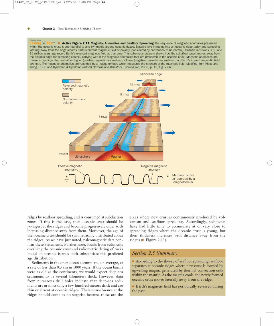
confirmed?Magnetic surveys of the oceanic crust revealed striped mag-netic anomalies (deviations from the average strength ofEarth’s magnetic field) in the rocks that are both parallel toand symmetric around the oceanic ridges (� Figure 2.11).Furthermore, the pattern of oceanic magnetic anomaliesmatches the pattern of magnetic reversals already knownfrom studies of continental lava flows (� Figure 2.9). Whenmagma wells up and cools along a ridge summit, it recordsEarth’s magnetic field at that time as either normal or re-versed. As new crust forms at the summit, the previouslyformed crust moves laterally away from the ridge. Thesemagnetic stripes represent times of normal and reversedpolarity at oceanic ridges (where upwelling magma formsnew oceanic crust), conclusively confirming Hess’s theory ofseafloor spreading.
The seafloor spreading theory also confirms that oceanbasins are geologically young features whose openings andclosings are partially responsible for continental movement(� Figure 2.12). Radiometric dating reveals that the oldestoceanic crust is somewhat less than 180 million years old,whereas the oldest continental crust is 3.96 billion years old.Although geologists do not universally accept the idea ofthermal convection cells as a driving mechanism for platemovement, most accept that plates are created at oceanicridges and destroyed at deep-sea trenches, regardless of thedriving mechanism involved.
Deep-Sea Drilling Project ResultsFor many geologists, the paleomagnetic data amassed insupport of continental drift and seafloor spreading wereconvincing. Results from the Deep-Sea Drilling Project (seeChapter 12) confirmed the interpretations made from ear-lier paleomagnetic studies. Cores of deep-sea sediments andseismic profiles obtained by the Glomar Challenger and otherresearch vessels have provided much of the data that supportthe seafloor spreading theory.
According to this theory, oceanic crust is continuouslyforming at mid-oceanic ridges, moves away from these
2.5 Magnetic Reversals and Seafloor Spreading 43
� Figure 2.10 Topography of the Atlantic Ocean Basin Artistic view of what the Atlantic Ocean basinwould look like without water. The major feature is the Mid-Atlantic Ridge, an oceanic ridge system that islonger than 65,000 km and divides the Atlantic Ocean basin in half. It is along such oceanic ridges thatthe seafloor is separating and new oceanic crust is forming from upwelling magma in Earth’s interior.
ALCO
A
11487_02_ch02_p032-069.qxd 2/16/06 9:31 AM Page 43
ridges by seafloor spreading, and is consumed at subductionzones. If this is the case, then oceanic crust should beyoungest at the ridges and become progressively older withincreasing distance away from them. Moreover, the age ofthe oceanic crust should be symmetrically distributed aboutthe ridges. As we have just noted, paleomagnetic data con-firm these statements. Furthermore, fossils from sedimentsoverlying the oceanic crust and radiometric dating of rocksfound on oceanic islands both substantiate this predictedage distribution.
Sediments in the open ocean accumulate, on average, ata rate of less than 0.3 cm in 1000 years. If the ocean basinswere as old as the continents, we would expect deep-seasediments to be several kilometers thick. However, datafrom numerous drill holes indicate that deep-sea sedi-ments are at most only a few hundred meters thick and arethin or absent at oceanic ridges. Their near-absence at theridges should come as no surprise because these are the
areas where new crust is continuously produced by vol-canism and seafloor spreading. Accordingly, sedimentshave had little time to accumulate at or very close tospreading ridges where the oceanic crust is young, buttheir thickness increases with distance away from theridges (� Figure 2.13).
Section 2.5 Summary● According to the theory of seafloor spreading, seafloorseparates at oceanic ridges where new crust is formed byupwelling magma generated by thermal convection cellswithin the mantle. As the magma cools, the newly formedoceanic crust moves laterally away from the ridge.
● Earth’s magnetic field has periodically reversed duringthe past.
44 Chapter 2 Plate Tectonics: A Unifying Theory
Midocean ridge
15 mya
9 mya
3 mya
PresentLithosphere Magma
Negative magneticanomaly
Magnetic profileas recorded by a
magnetometer
+
–
+
–
Positive magneticanomaly
Reversed magneticpolarity
Normal magneticpolarity
� Active Figure 2.11 Magnetic Anomalies and Seafloor Spreading The sequence of magnetic anomalies preservedwithin the oceanic crust is both parallel to and symmetric around oceanic ridges. Basaltic lava intruding into an oceanic ridge today and spreadinglaterally away from the ridge records Earth’s current magnetic field or polarity (considered by convention to be normal). Basaltic intrusions 3, 9, and15 million years ago record Earth’s reversed magnetic field at that time. This schematic diagram shows how the solidified basalt moves away fromthe oceanic ridge (or spreading center), carrying with it the magnetic anomalies that are preserved in the oceanic crust. Magnetic anomalies aremagnetic readings that are either higher (positive magnetic anomalies) or lower (negative magnetic anomalies) than Earth’s current magnetic fieldstrength. The magnetic anomalies are recorded by a magnetometer, which measures the strength of the magnetic field. Modified from Kious andTilling, USGS and Hyndman & Hyndman Natural Hazards and Disasters, Brooks/Cole, 2006, p. 15, Fig. 2.6b.
11487_02_ch02_p032-069.qxd 2/27/06 5:00 PM Page 44

● Magnetic anomalies in oceanic crust, which are paral-lel to and symmetric around oceanic ridges, match thepattern of magnetic reversals seen in continental lavaflows, thus confirming that new oceanic crust is formingalong oceanic ridges and moving the seafloor laterallyaway from them.
● Cores of deep-sea sediments also confirm the theory ofseafloor spreading in that the sediments directly overly-ing the oceanic crust get older with increasing distancefrom oceanic ridges, and the sediments become thickermoving away from the ridge.
2.5 Magnetic Reversals and Seafloor Spreading 45
� Figure 2.12 Age of the World’s Ocean Basins The age of the world’s ocean basins havebeen determined from magnetic anomalies preserved in oceanic crust. The red colors adjacentto the oceanic ridges are the youngest oceanic crust. Moving laterally away from the ridges, the red colors grade to yellow at 48 million years, to green at 68 million years ago, and to darkblue some 155 million years ago. The darkest blue color is adjacent to the continental marginsand is just somewhat less than 180 million years old. How does the age of the oceaniccrust confirm the seafloor spreading theory? Based on magnetic anomalies, the age of the
oceanic crust gets progressively older away from the oceanic ridges where it is being formed.
This means it is moving away from the oceanic ridges; that is, the seafloor is spreading.
NOA
A-N
GDC
Deep-sea sediments Mid-ocean ridge
Ocean lithosphere
Asthenosphere MagmaSubduction
� Figure 2.13 Deep-Sea Sediments and Seafloor Spreading The total thickness of deep-sea sediments increases away from oceanic ridges.This is because oceanic crust becomes older away from oceanic ridges, and there has been more time for sediment to accumulate.
11487_02_ch02_p032-069.qxd 2/16/06 9:31 AM Page 45
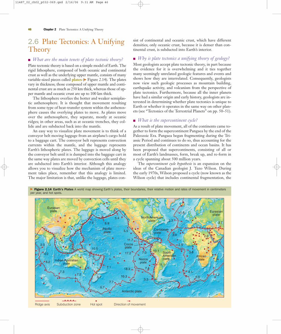
2.6 Plate Tectonics: A UnifyingTheory� What are the main tenets of plate tectonic theory?Plate tectonic theory is based on a simple model of Earth. Therigid lithosphere, composed of both oceanic and continentalcrust as well as the underlying upper mantle, consists of manyvariable-sized pieces called plates (� Figure 2.14). The platesvary in thickness; those composed of upper mantle and conti-nental crust are as much as 250 km thick, whereas those of up-per mantle and oceanic crust are up to 100 km thick.
The lithosphere overlies the hotter and weaker semiplas-tic asthenosphere. It is thought that movement resultingfrom some type of heat-transfer system within the asthenos-phere causes the overlying plates to move. As plates moveover the asthenosphere, they separate, mostly at oceanicridges; in other areas, such as at oceanic trenches, they col-lide and are subducted back into the mantle.
An easy way to visualize plate movement is to think of aconveyor belt moving luggage from an airplane’s cargo holdto a baggage cart. The conveyor belt represents convectioncurrents within the mantle, and the luggage representsEarth’s lithospheric plates. The luggage is moved along bythe conveyor belt until it is dumped into the baggage cart inthe same way plates are moved by convection cells until theyare subducted into Earth’s interior. Although this analogyallows you to visualize how the mechanism of plate move-ment takes place, remember that this analogy is limited.The major limitation is that, unlike the luggage, plates con-
sist of continental and oceanic crust, which have differentdensities; only oceanic crust, because it is denser than con-tinental crust, is subducted into Earth’s interior.
� Why is plate tectonics a unifying theory of geology?Most geologists accept plate tectonic theory, in part becausethe evidence for it is overwhelming and it ties togethermany seemingly unrelated geologic features and events andshows how they are interrelated. Consequently, geologistsnow view such geologic processes as mountain building,earthquake activity, and volcanism from the perspective ofplate tectonics. Furthermore, because all the inner planetshave had a similar origin and early history, geologists are in-terested in determining whether plate tectonics is unique toEarth or whether it operates in the same way on other plan-ets (see “Tectonics of the Terrestrial Planets” on pp. 50–51).
� What is the supercontinent cycle?As a result of plate movement, all of the continents came to-gether to form the supercontinent Pangaea by the end of thePaleozoic Era. Pangaea began fragmenting during the Tri-assic Period and continues to do so, thus accounting for thepresent distribution of continents and ocean basins. It hasbeen proposed that supercontinents, consisting of all ormost of Earth’s landmasses, form, break up, and re-form ina cycle spanning about 500 million years.
The supercontinent cycle hypothesis is an expansion on theideas of the Canadian geologist J. Tuzo Wilson. During the early 1970s, Wilson proposed a cycle (now known as theWilson cycle) that includes continental fragmentation, the
46 Chapter 2 Plate Tectonics: A Unifying Theory
Eurasianplate
Africanplate
Caribbeanplate
North Americanplate
Nazcaplate
SouthAmericanplate
Cocosplate
Pacificplate
Antarctic plate
Indian-Australianplate
Eurasianplate
2.0
4.0
6.2
7.37.2
3.7
7.1
10.5
7.9 6.9
5.4
5.5
11.7
17.2
18.3
10.3
7.7
5.7
3.3
7.411.1
10.17.0
3.0
2.3
1.8
2.5
3.8
4.1
1.31.7
2.0
3.7
Subduction zoneRidge axis Direction of movementHot spot
� Figure 2.14 Earth’s Plates A world map showing Earth’s plates, their boundaries, their relative motion and rates of movement in centimetersper year, and hot spots.
11487_02_ch02_p032-069.qxd 2/16/06 9:31 AM Page 46

opening and closing of an ocean basin, and re-assembly ofthe continent. According to the supercontinent cycle hy-pothesis, heat accumulates beneath a supercontinent be-cause the rocks of continents are poor conductors of heat.As a result of the heat accumulation, the supercontinentdomes upward and fractures. Basaltic magma rising frombelow fills the fractures. As a basalt-filled fracture widens, itbegins subsiding and forms a long, narrow ocean such as thepresent-day Red Sea. Continued rifting eventually forms anexpansive ocean basin such as the Atlantic.
One of the most convincing arguments for the propo-nents of the supercontinent cycle hypothesis is the “surpris-ing regularity” of mountain building caused by compressionduring continental collisions. These mountain-buildingepisodes occur about every 400 to 500 million years and arefollowed by an episode of rifting about 100 million yearslater. In other words, a supercontinent fragments and itsindividual plates disperse following a rifting episode, an in-terior ocean forms, and then the dispersed fragments re-assemble to form another supercontinent.
The supercontinent cycle is yet another example of howinterrelated the various systems and subsystems of Earth areand how they operate over vast periods of geologic time.
Section 2.6 Summary● The main tenets of plate tectonic theory are that therigid lithosphere consists of numerous variable-sized piecescalled plates. These plates move over the hotter and weakersemiplastic asthenosphere as a result of some type of heat-transfer system within the asthenosphere. Plates separate,mostly at oceanic ridges, and collide, usually at oceanictrenches, where they are subducted back into the mantle.
● Plate tectonics is considered a unifying theory of geol-ogy because it explains how many geologic features,processes, and events are interrelated.
● In the supercontinent cycle, all or most of Earth’s land-masses come together to form a supercontinent, such asPangaea, then break up, producing ocean basins, andthen re-form in a cycle spanning about 500 million years.
2.7 The Three Types of Plate Boundaries� What are the three types of plate boundaries?Because it appears that plate tectonics have operated since atleast the Proterozoic Eon, it is important that we under-stand how plates move and interact with each other and howancient plate boundaries are recognized. After all, themovement of plates has profoundly affected the geologicand biologic history of this planet.
Geologists recognize three major types of plate bound-aries: divergent, convergent, and transform (Table 2.1). Alongthese boundaries new plates are formed, are consumed, orslide laterally past each other. Interaction of plates at theirboundaries accounts for most of Earth’s volcanic eruptionsand earthquakes as well as the formation and evolution of itsmountain systems.
� What are divergent boundaries?Divergent plate boundaries or spreading ridges occur whereplates are separating and new oceanic lithosphere is forming.Divergent boundaries are places where the crust is extended,thinned, and fractured as magma, derived from the partialmelting of the mantle, rises to the surface. The magma isalmost entirely basaltic and intrudes into vertical fractures toform dikes and pillow lava flows (see Figure 5.7). As successiveinjections of magma cool and solidify, they form new oceaniccrust and record the intensity and orientation of Earth’smagnetic field (� Figure 2.11). Divergent boundaries mostcommonly occur along the crests of oceanic ridges—the Mid-Atlantic Ridge, for example. Oceanic ridges are thus character-ized by rugged topography with high relief resulting from thedisplacement of rocks along large fractures, shallow-depthearthquakes, high heat flow, and basaltic flows or pillow lavas.
Divergent boundaries are also present under conti-nents during the early stages of continental breakup. When magma wells up beneath a continent, the crust is initially elevated, stretched, and thinned, producing frac-tures, faults, rift valleys, and volcanic activity (� Fig–ure 2.15). As magma intrudes into faults and fractures, it
2.7 The Three Types of Plate Boundaries 47
T a b l e 2 . 1
Types of Plate BoundariesType Example Landforms Volcanism
Divergent
Oceanic Mid-Atlantic Ridge Mid-oceanic ridge with axial rift valley Basalt
Continental East African Rift Valley Rift valley Basalt and rhyolite, no andesite
Convergent
Oceanic–oceanic Aleutian Islands Volcanic island arc, offshore oceanic trench Andesite
Oceanic–continental Andes Offshore oceanic trench, volcanic mountain Andesitechain, mountain belt
Continental–continental Himalayas Mountain belt Minor
Transform San Andreas fault Fault valley Minor
11487_02_ch02_p032-069.qxd 2/27/06 6:48 PM Page 47

48 Chapter 2 Plate Tectonics: A Unifying Theory
Volcanic activity
Rift valley
Magma
Continental crust
Coastal mountainrange
Continental “seaboard”(coastal mountains gone)
Wide ocean
Narrow fault-bounded sea
� Geo-focus/Active Figure 2.15 History of a Divergent Plate Boundary
Continued spreading further separates the continent untilit splits apart and a narrow seaway develops. The RedSea, which separates the Arabian Peninsula from Africa, is a good example of this stage of development.
c
As the crust is stretched and thinned, rift valleys develop and lavaflows onto the valley floors, such as seen today in the East African Rift Valley.
b
As spreading continues, an oceanic ridgesystem forms, and an ocean basin developsand grows. The Mid-Atlantic Ridgeillustrates this stage in a divergent plateboundary’s history.
d
Rising magma beneath a continent pushesthe crust up, producing numerous fractures,faults, rift valleys, and volcanic activity.
a
11487_02_ch02_p032-069.qxd 2/27/06 6:48 PM Page 48

solidifies or flows out onto the surface as lava flows; the latteroften covering the rift valley floor (� Figure 2.15b). The EastAfrican Rift Valley is an excellent example of continentalbreakup at this stage (� Figure 2.16a).
As spreading proceeds, some rift valleys continue tolengthen and deepen until the continental crust eventuallybreaks and a narrow linear sea is formed, separating twocontinental blocks (� Figure 2.15c). The Red Sea separatingthe Arabian Peninsula from Africa (� Figure 2.16b) and theGulf of California, which separates Baja California from
mainland Mexico, are good examples of this more advancedstage of rifting.
As a newly created narrow sea continues to enlarge, it mayeventually become an expansive ocean basin such as theAtlantic Ocean basin is today, separating North and SouthAmerica from Europe and Africa by thousands of kilometers(� Figure 2.15d). The Mid-Atlantic Ridge is the boundarybetween these diverging plates (� Figure 2.10); the Americanplates are moving westward, and the Eurasian and Africanplates are moving eastward.
2.7 The Three Types of Plate Boundaries 49
AfricanPlate
Arabian PlateR
ed
Se
a
� Figure 2.16 East African Rift Valley and the Red Sea—Present-Day Examples of Divergent Plate Boundaries The East African Rift Valleyand the Red Sea represent different stages in the history of a divergent plate boundary.
NAS
A/Co
rbis
The East African Rift Valley is being formed by the separation ofeastern Africa from the rest of the continent along a divergent plateboundary.
a
The Red Sea represents a more advanced stage of rifting, in which twocontinental blocks (Africa and the Arabian Peninsula) are separated bya narrow sea.
b
11487_02_ch02_p032-069.qxd 2/27/06 6:48 PM Page 49

Tectonics of the Terrestrial PlanetsThe four inner, or terrestrial, planets—Mercury, Venus,Earth, and Mars—all had a similar early history involvingaccretion, differentiation into a metallic core and silicatemantle and crust, and formation of an early atmosphere byoutgassing. Their early history was also marked by wide-
spread volcanism and meteorite impacts, both of whichhelped modify their surfaces.
Whereas the other three terrestrial planets as well as someof the Jovian moons display internal activity, Earth appears tobe unique in that its surface is broken into a series of plates.
� 4. Of all the planets, Venus is the most similar in size and mass to Earth, but itdiffers in most other respects. Whereas Earth is dominated by plate tectonics,volcanism seems to have been the dominant force in the evolution of the Venu-sian surface. Even though no active volcanism has been observed on Venus, thevarious-sized volcanic features and what appear to be folded mountains indicatea once-active planetary interior. All of these structures appear to be the productsof rising convection currents of magma pushing up under the crust and thensinking back into the Venusian interior.
� 5. A color-enhanced photomosaic of Venusbased on radar images beamed back to Earthby the Magellan spacecraft. This imageshows impact craters and volcanic featurescharacteristic of the planet.
� 7. Arrows point to a600-km segment ofVenus’ 6800-km longBaltis Vallis, the longestknown lava flow channelin our solar system.
NAS
A
JPL/
NAS
A
JPL/
NAS
A
� 3. Seven scarps (indicated by arrows) can clearly beseen in this image. These scarps might have formedwhen Mercury cooled and contracted early in its history.
� 2. A color-enhanced photomosaic of Mercuryshows its heavily cratered surface, which haschanged very little since its early history.
� 1. Images of Mercury sent back by Mariner 10 show aheavily cratered surface with the largest impact basinsfilled with what appear to be lava flows similar to thelava plains on Earth’s moon. The lava plains are notdeformed, however, indicating that there has been little or no tectonic activity.
Another feature of Mercury’s surface is a large number of scarps, a feature usually associated with earthquake activity. Yet some scientists think that these scarps formed when Mercury cooled and contracted.
JPL/
NAS
A
Cour
tesy
of V
icto
r Roy
er
� 6. Venus’ Aine Corona, about 200 km in diameter, is ringed by concentric faults, suggesting that it was pushed up by rising magma. A network of fractures is visiblein the upper right of this image, as well as a recent lava flow at the center of thecorona, several volcanic domes in the lower portion of the image, and a largevolcanic pancake dome in the upper left of the image.
11487_02_ch02_p032-069.qxd 2/17/06 8:24 AM Page 50

� 8. Volcano Sapas Mons contains two lava-filled calderas and is flanked by lava flows,attesting to the volcanic activity that was once common on Venus.
� 13. Volcanic features of Io, the innermost moon of Jupiter.As shown in these digitally enhanced color images, Io is avery volcanically active moon.
� 12. Although not a terrestrial planet, Io, the innermost ofJupiter’s Galilean moons, must be mentioned. Images from theVoyager and Galileo spacecrafts show that Io has no impactcraters. In fact, more than a hundred active volcanoes are visibleon the moon’s surface, and the sulfurous gas and ash erupted by these volcanoes bury any newly formed meteorite impactcraters. Because of its proximity to Jupiter, the heat source of Iois probably tidal heating, in which the resulting friction is enoughto at least partially melt Io’s interior and drive its volcanoes.
NAS
A
NAS
A
NAS
A
JPL/
NAS
A
JPL/
NAS
A
� 11. A vertical view of Olympus Mons, a shield volcano and the largest volcanoknown in our solar system. The edge of the Olympus Mons caldera is markedby a cliff several kilometers high. This huge summit crater is large enough to contain the greater New York City metropolitan area.
� 9. Mars, the Red Planet, has numerous features that indicate an extensive early period ofvolcanism. These include Olympus Mons, the solar system’s largest volcano, lava flows, anduplifted regions thought to have resulted from mantle convection. In addition to volcanic features, Mars displays abundant evidence of tensional tectonics, including numerous faults and large fault-produced valley structures. Although Mars was tectonically active during the past, no evidence indicates that plate tectonics comparable to those on Earth have ever occurred there.
� 10. A photomosaic of Mars shows avariety of geologic structures, includingthe southern polar ice cap.
USGS
11487_02_ch02_p032-069.qxd 2/17/06 5:45 PM Page 51

� What features in the geologic record indicateancient rifting?
Associated with regions of continental rifting are faults,dikes (vertical intrusive igneous bodies), sills (horizontalintrusive igneous bodies), lava flows, and thick sedimen-tary sequences within rift valleys, all features that are pre-served in the geologic record. The Triassic fault basins ofthe eastern United States are a good example of ancientcontinental rifting (� Figure 2.17a). These fault basinsmark the zone of rifting that occurred when North Amer-ica split apart from Africa. The basins contain thousandsof meters of continental sediment and are riddled withdikes and sills.
Pillow lavas, in association with deep-sea sediment, arealso evidence of ancient rifting. The presence of pillow lavasmarks the formation of a spreading ridge in a narrow linearsea. A narrow linear sea forms when the continental crust inthe rift valley finally breaks apart, and the area is flooded byseawater. Magma, intruding into the sea along this newlyformed spreading ridge, solidifies as pillow lavas, which arepreserved in the geologic record, along with the sedimentbeing deposited on them.
� What are convergent boundaries?Whereas new crust forms at divergent plate boundaries,older crust must be destroyed and recycled in order for theentire surface area of Earth to remain the same. Otherwise,
we would have an expanding Earth. Such plate destructiontakes place at convergent plate boundaries, where twoplates collide and the leading edge of one plate is subductedbeneath the margin of the other plate and eventually is in-corporated into the asthenosphere. A dipping plane ofearthquake foci, called a Benioff (or sometimes Benioff-Wadati) zone, defines a subduction zone (see Figure 10.5).Most of these planes dip from oceanic trenches beneathadjacent island arcs or continents, marking the surface ofslippage between the converging plates.
Deformation, volcanism, mountain building, metamor-phism, earthquake activity, and deposits of valuable mineralores characterize convergent boundaries. Three types ofconvergent plate boundaries are recognized: oceanic–oceanic,oceanic–continental, and continental–continental.
Oceanic–Oceanic Boundaries When two oceanic plates converge, one is subducted be-neath the other along an oceanic–oceanic plate boundary(� Figure 2.18a). The subducting plate bends downward toform the outer wall of an oceanic trench. A subduction com-plex, composed of wedge-shaped slices of highly folded andfaulted marine sediments and oceanic lithosphere scrapedoff the descending plate, forms along the inner wall of theoceanic trench. As the subducting plate descends into themantle, it is heated and partially melted, generating magma,commonly of andesitic composition (see Chapter 4). This
52 Chapter 2 Plate Tectonics: A Unifying Theory
BostonAlbany
Washington, D.C
ME
NH
VT
NY
PA
OH
WV
VA
NC
MDNJ
CT
MA
KY
TN
MI
DE
HalifaxCANADA
AT L A N T I C
O C E A N
L a k eE r i e
L a k eO n t a r i o
L a k e H u r o n
RI
Palisades
� Figure 2.17 Triassic Fault-Block Basins of Eastern North America—An Example of Ancient Rifting
Cour
tesy
of J
ohn
Faiv
re
Triassic fault-block basin deposits appear in numerous locationsthroughout eastern North America. These fault-block basins aregood examples of ancient continental rifting, and during the TriassicPeriod they looked like today’s fault-block basins (rift valleys) of theEast African Rift Valley.
a Palisades of the Hudson River. This sill (tabular-shaped horizontaligneous intrusion) was one of many that were intruded into thefault-block basin sediments during the Late Triassic rifting thatmarked the initial separation of North America from Africa.
b
11487_02_ch02_p032-069.qxd 2/16/06 9:31 AM Page 52

2.7 The Three Types of Plate Boundaries 53
Continent
Back arc spreading
Mantle upwellingassociated withnearby subduction Partial
melting Subductingoceanic crust
Volcanicisland arc
Marginal sea(back arc)
Forearc
Centralocean
Japan
Upper man
tle
Asthen
osphe
re
Partial melting
Mountain range
ContinentalcrustThrust zone
Continentalcrust
India
Rift faulting,Tibetanplateau
IndianOcean
Little or nopartial melting
Oceaniccrust
Secondary riftingcaused by collision N
0 1000Km
Asthenosphere
Upper mantle
Himalaya Mts.
Forearc
Vocanic arcmountain range
Continentalinterior
Continental
crust
Panama
0 1000Km
PacificOcean
AmazonRiver
AsthenospherePartialmeltingSubducting
oceanic crust
Subductioncomplex
Upper mantle
Andean volcanic arc
South America
N
� Geo-focus/Active Figure 2.18 Three Types of Convergent Plate Boundaries
Oceanic–oceanic plateboundary. An oceanictrench forms where oneoceanic plate is subductedbeneath another. On thenonsubducted plate, avolcanic island arc formsfrom the rising magmagenerated from thesubducting plate. TheJapanese Islands are avolcanic island arc resultingfrom the subduction of oneoceanic plate beneathanother oceanic plate.
a
Oceanic–continental plate boundary. When an oceanic plate is subducted beneath acontinental plate, an andesitic volcanic mountain range is formed on the continentalplate as a result of rising magma. The Andes Mountains in Peru are one of the bestexamples of continuing mountain building at an oceanic–continental plate boundary.
b
Continental–continental plate boundary. When two con-tinental plates converge, neither is subducted because of their great thickness and low and equal densities. Asthe two continental plates collide, a mountain range isformed in the interior of a new and larger continent. TheHimalayas in central Asia resulted from the collisionbetween India and Asia approximately 40 to 50 millionyears ago.
c
11487_02_ch02_p032-069.qxd 2/16/06 9:32 AM Page 53

magma is less dense than the surrounding mantle rocks andrises to the surface of the nonsubducted plate to form acurved chain of volcanoes called a volcanic island arc (anyplane intersecting a sphere makes an arc). This arc is nearlyparallel to the oceanic trench and is separated from it by adistance of up to several hundred kilometers—the distancedepending on the angle of dip of the subducting plate (� Figure 2.18a).
In those areas where the rate of subduction is faster thanthe forward movement of the overriding plate, the lithos-phere on the landward side of the volcanic island arc may besubjected to tensional stress and stretched and thinned, re-sulting in the formation of a back-arc basin. This back-arcbasin may grow by spreading if magma breaks through thethin crust and forms new oceanic crust (� Figure 2.18a). Agood example of a back-arc basin associated with anoceanic–oceanic plate boundary is the Sea of Japan betweenthe Asian continent and the islands of Japan.
Most present-day active volcanic island arcs are in thePacific Ocean basin and include the Aleutian Islands, theKermadec–Tonga arc, and the Japanese (� Figure 2.18a) andPhilippine Islands. The Scotia and Antillean (Caribbean)island arcs are in the Atlantic Ocean basin.
Oceanic–Continental Boundaries When an oceanic and a continental plate converge, thedenser oceanic plate is subducted under the continentalplate along an oceanic–continental plate boundary(� Figure 2.18b). Just as at oceanic–oceanic plate bound-aries, the descending oceanic plate forms the outer wall ofan oceanic trench.
The magma generated by subduction rises beneath thecontinent and either crystallizes as large intrusive igneousbodies (called plutons) before reaching the surface or eruptsat the surface to produce a chain of andesitic volcanoes (also
54 Chapter 2 Plate Tectonics: A Unifying Theory
You’ve been selected to be part of the first astronautteam to go to Mars. While your two fellow crew-
members descend to the Martian surface, you’ll be stay-ing in the command module and circling the Red Planet.As part of the geologic investigation of Mars, one of thecrewmembers will be mapping the geology around thelanding site and deciphering the geologic history of the area. Your job will be to observe and photograph theplanet’s surface and try to determine whether Mars hadan active plate tectonic regime in the past and whetherthere is current plate movement. What features will youlook for, and what evidence might reveal current or pre-vious plate activity?
What Would You Do?What Would You Do?
called a volcanic arc). An excellent example of an oceanic–continental plate boundary is the Pacific coast of SouthAmerica, where the oceanic Nazca plate is currently beingsubducted beneath South America (� Figure 2.18b; see alsoChapter 13). The Peru–Chile Trench marks the site of sub-duction, and the Andes Mountains are the resulting volcanicmountain chain on the nonsubducting plate.
Continental–Continental Boundaries Two continents approaching each other are initially sepa-rated by an ocean floor that is being subducted under onecontinent. The edge of that continent displays the featurescharacteristic of oceanic–continental convergence. As theocean floor continues to be subducted, the two continentscome closer together until they eventually collide. Becausecontinental lithosphere, which consists of continental crustand the upper mantle, is less dense than oceanic lithosphere(oceanic crust and upper mantle), it cannot sink into theasthenosphere. Although one continent may partly slide un-der the other, it cannot be pulled or pushed down into asubduction zone (� Figure 2.18c).
When two continents collide, they are welded togetheralong a zone marking the former site of subduction. At thiscontinental–continental plate boundary, an interior moun-tain belt is formed consisting of deformed sediments andsedimentary rocks, igneous intrusions, metamorphic rocks,and fragments of oceanic crust. In addition, the entire regionis subjected to numerous earthquakes. The Himalayas incentral Asia, the world’s youngest and highest mountain sys-tem, resulted from the collision between India and Asia thatbegan 40 to 50 million years ago and is still continuing (� Fig-ure 2.18c; see Chapter 13).
� How can ancient subduction zones be recognized in the geologic record?
Igneous rocks provide one clue to ancient subductionzones. The magma erupted at the surface, forming islandarc volcanoes and continental volcanoes, is of andesiticcomposition. Another clue is the zone of intensely de-formed rocks between the deep-sea trench where subduc-tion is taking place and the area of igneous activity. Here,sediments and submarine rocks are folded, faulted, andmetamorphosed into a chaotic mixture of rocks called amélange.
During subduction, pieces of oceanic lithosphere aresometimes incorporated into the mélange and accretedonto the edge of the continent. Such slices of oceanic crustand upper mantle are called ophiolites (� Figure 2.19). Theyconsist of a layer of deep-sea sediments that includegraywackes (poorly sorted sandstones containing abundantfeldspar minerals and rock fragments, usually in a clay-richmatrix), black shales, and cherts (see Chapter 7). Thesedeep-sea sediments are underlain by pillow lavas, a sheeteddike complex, massive gabbro (a dark intrusive igneous
11487_02_ch02_p032-069.qxd 2/16/06 9:32 AM Page 54

rock), and layered gabbro, all of which form the oceaniccrust. Beneath the gabbro is peridotite, which probablyrepresents the upper mantle. The presence of ophiolite inan outcrop or drilling core is a key indication of plate con-vergence along a subduction zone.
Elongate belts of folded and faulted marine sedimentaryrocks, andesites, and ophiolites are found in the Appalachians,Alps, Himalayas, and Andes mountains. The combination ofsuch features is good evidence that these mountain ranges re-sulted from deformation along convergent plate boundaries.
� What are transform boundaries?The third type of plate boundary is a transform plateboundary. These mostly occur along fractures in theseafloor, known as transform faults, where plates slide later-ally past each other roughly parallel to the direction ofplate movement. Although lithosphere is neither creatednor destroyed along a transform boundary, the movementbetween plates results in a zone of intensely shattered rockand numerous shallow-depth earthquakes.
Transform faults “transform” or change one type ofmotion between plates into another type of motion. Mostcommonly, transform faults connect two oceanic ridgesegments, but they can also connect ridges to trenches and trenches to trenches (� Figure 2.20). Although themajority of transform faults are in oceanic crust and aremarked by distinct fracture zones, they may also extendinto continents.
One of the best-known transform faults is the San Andreasfault in California. It separates the Pacific plate from theNorth American plate and connects spreading ridges in theGulf of California with the Juan de Fuca and Pacific plates offthe coast of northern California (� Figure 2.21). Many of theearthquakes affecting California are the result of movementalong this fault (see Chapter 10).
Unfortunately, transform faults generally do not leaveany characteristic or diagnostic features except the obvi-ous displacement of the rocks with which they are associ-ated. This displacement is usually large, on the order oftens to hundreds of kilometers. Such large displacementsin ancient rocks can sometimes be related to transformfault systems.
Log into GeologyNow and select this chapter to
work through Geology Interactive activities on
“Plate Boundaries” (click Plate Tectonics0Plate
Boundaries) and “Triple Junctions and Seafloor
Studies” (click Plate Tectonics0Triple Junctions
and Seafloor Studies).
Section 2.7 Summary● The three major types of plate boundaries are diver-gent, convergent, and transform.
● Divergent plate boundaries occur where plates are sep-arating and new oceanic lithosphere is forming. They arecharacterized by thinning and fracturing of the crust, for-mation of rift valleys, intrusion of magma, and shallow-depth earthquakes.
● Zones of ancient continental rifting can be recognizedby faults, dikes, sills, lava flows, and thick sedimentarysequences, whereas pillow lavas and associated deep-seasediments are evidence of ancient spreading ridges.
● Convergent plate boundaries occur where two platescollide, and the leading edge of one plate is subductedbeneath the margin of the other plate. They are charac-terized by metamorphism, mountain building, volcanicand earthquake activity, and the formation of variousmineral deposits. Three types of convergent plateboundaries are recognized: oceanic–oceanic, where twooceanic plates converge, oceanic–continental, where anoceanic plate is subducted beneath the continental plate,and continental–continental, where an interior mountainbelt is formed.
● Intensely deformed rocks, andesite lavas, and ophiolitesare all evidence of ancient subduction zones, markingformer convergent plate boundaries.
● Transform plate boundaries occur along fractures inthe seafloor, called transform faults, where plates slidelaterally past each other.
2.7 The Three Types of Plate Boundaries 55
Deep-seasediments
Pillowlavas
Sheeteddikes
Massivegabbro
Layeredgabbro
Peridotite
Oceaniccrust
Uppermantle
� Figure 2.19 Ophiolites Ophiolites are sequences of rock on landconsisting of deep-sea sediments, oceanic crust, and upper mantle.Ophiolites are one feature used to recognize ancient convergent plateboundaries.
11487_02_ch02_p032-069.qxd 2/16/06 9:32 AM Page 55

56 Chapter 2 Plate Tectonics: A Unifying Theory
“Subducted” oceanic ridge segment
Transform fault
Magma
Oceanic crust
Mid-oceanridge
Fracture zone
Fracture zoneTrench
“Subducted” oceanic ridge segment
Transform fault
Fracturezone
Transform fault
Most transform faultsconnect two oceanicridge segments.
a
A transform fault canconnect a ridge and atrench.
b
A transform fault canalso link two trenches.
c
� Geo-focus Figure 2.20 Transform Plate Boundaries Horizontal movement between plates occurs along transformfaults. Extensions of transform faults on the seafloor form fracture zones.
11487_02_ch02_p032-069.qxd 2/16/06 9:32 AM Page 56

2.8 Hot Spots: An IntraplateFeature� What are hot spots and what do they tell us about
plate movement?Before leaving the topic of plate boundaries, we shouldmention an intraplate feature found beneath both oceanicand continental plates. A hot spot is the location onEarth’s surface where a stationary column of magma, orig-inating deep within the mantle (mantle plume), has slowlyrisen to the surface and formed a volcano (� Figure 2.22).Because mantle plumes apparently remain stationary(although some evidence suggests that they might not)within the mantle while plates move over them, the re-sulting hot spots leave a trail of extinct and progressivelyolder volcanoes called aseismic ridges that record themovement of the plate.
One of the best examples of aseismic ridges and hot spotsis the Emperor Seamount–Hawaiian Island chain (� Fig-ure 2.22). This chain of islands and seamounts (structures ofvolcanic origin rising higher than 1 km above the seafloor)extends from the island of Hawaii to the Aleutian Trench offAlaska, a distance of some 6000 km, and consists of morethan 80 volcanic structures.
Currently, the only active volcanoes in this island chain areon the islands of Hawaii and Maui and the Loihi Seamount.The rest of the islands are extinct volcanic structures that be-come progressively older toward the north and northwest.This means that the Emperor Seamount–Hawaiian Islandchain records the direction that the Pacific plate traveled as itmoved over an apparently stationary mantle plume. In thiscase, the Pacific plate first moved in a north-northwesterly di-rection and then, as indicated by the sharp bend in the chain,changed to a west-northwesterly direction about 43 millionyears ago. The reason the Pacific plate changed directions is not known, but the shift might be related to the collision of India with the Asian continent at around the same time (see Figure 13.22).
Mantle plumes and hot spots help geologists explainsome of the geologic activity occurring within plates asopposed to activity occurring at or near plate boundaries.In addition, if mantle plumes are essentially fixed withrespect to Earth’s rotational axis, they can be used todetermine not only the direction of plate movement butalso the rate of movement. They can also provide refer-ence points for determining paleolatitude, an importanttool when reconstructing the location of continents in thegeologic past.
Section 2.8 Summary● Hot spots are locations where stationary columns ofmagma from the mantle (mantle plumes) have risen tothe surface and formed volcanoes.
2.8 Hot Spots: An Intraplate Feature 57
PACIFIC
PLATE
P A C I F I C
O C E A N
OREGON
NEVADACALIFORNIA
NORTH AMERICANPLATE
BRITISHCOLUMBIA
WASHINGTONJUANDE FUCA
PLATE
Juan
de
Fuca
Rid
ge
SanA
ndreasfault
Los Angeles
San Francisco
Seattle
Oceanicridge
Zone ofsubduction
Transformfaults
� Figure 2.21 The San Andreas Fault—A Transform PlateBoundary The San Andreas fault is a transform fault separating thePacific plate from the North American plate. It connects the spread-ing ridges in the Gulf of California with the Juan de Fuca and Pacificplates off the coast of northern California. Movement along the SanAndreas fault has caused numerous earthquakes. The insert photo-graph shows a segment of the San Andreas fault as it cuts throughthe Carrizo Plain, California.
USGS
11487_02_ch02_p032-069.qxd 2/16/06 9:32 AM Page 57

● Because the mantle plumes apparently remain station-ary while plates move over them, the trail of hot spots,marked by extinct and progressively older volcanoes,records the direction and rate of plate movement.
2.9 Plate Movement and Motion� How can the rate and direction of plate movement
be determined?How fast and in what direction are Earth’s plates moving?Do they all move at the same rate? Rates of plate movementcan be calculated in several ways. The least accurate methodis to determine the age of the sediments immediately aboveany portion of the oceanic crust and then divide the distancefrom the spreading ridge by that age. Such calculations givean average rate of movement.
A more accurate method of determining both the aver-age rate of movement and the relative motion is by datingthe magnetic anomalies in the crust of the seafloor. Thedistance from an oceanic ridge axis to any magnetic anom-aly indicates the width of new seafloor that formed duringthat time interval. Thus, for a given interval of time, thewider the strip of seafloor, the faster the plate has moved.
In this way, not only can the present average rate of move-ment and relative motion be determined (� Figure 2.14),but the average rate of movement during the past can alsobe calculated by dividing the distance between anomaliesby the amount of time elapsed between anomalies.
Geologists use magnetic anomalies not only to calculatethe average rate of plate movement but also to determineplate positions at various times in the past. Because mag-netic anomalies are parallel and symmetric with respect tospreading ridges, all one must do to determine the posi-tions of continents when particular anomalies formed is tomove the anomalies back to the spreading ridge, which willalso move the continents with them (� Figure 2.23). Un-fortunately, subduction destroys oceanic crust and the mag-netic record it carries. Thus we have an excellent record ofplate movements since the breakup of Pangaea, but not asgood an understanding of plate movement before that time.
The average rate of movement as well as the relative mo-tion between any two plates can also be determined by satel-lite–laser ranging techniques. Laser beams from a station onone plate are bounced off a satellite (in geosynchronous or-bit) and returned to a station on a different plate. As theplates move away from each other, the laser beam takesmore time to go from the sending station to the stationarysatellite and back to the receiving station. This difference inelapsed time is used to calculate the rate of movement andthe relative motion between plates.
58 Chapter 2 Plate Tectonics: A Unifying Theory
Kamchatka
Kauai3.8–5.6
Oahu2.3–3.3
Molokai1.3–1.8 Maui
0.8–1.3
Hawaii 0.7 topresent
EmperorSeamounts
Sea level
Hawaiian
Oceanic crustHawaiian Islands
Upper mantle
Directionof plate movement
hot spot
AleutianIslands
Sea level
Alaskancoast
Sea level
Asthenosphere Mantleplume
� Active Figure 2.22 Hot Spots A hot spot is the location where a stationary mantle plume has risen to the surface andformed a volcano. The Emperor Seamount–Hawaiian Island chain formed as a result of the Pacific plate moving over a mantle plume, and the lineof volcanic islands in this chain traces the direction of plate movement. The Hawaiian hot spot currently underlies the southern half of the island ofHawaii and adjoining offshore area. The numbers indicate the ages of the Hawaiian Islands in millions of years.
11487_02_ch02_p032-069.qxd 2/17/06 8:24 AM Page 58
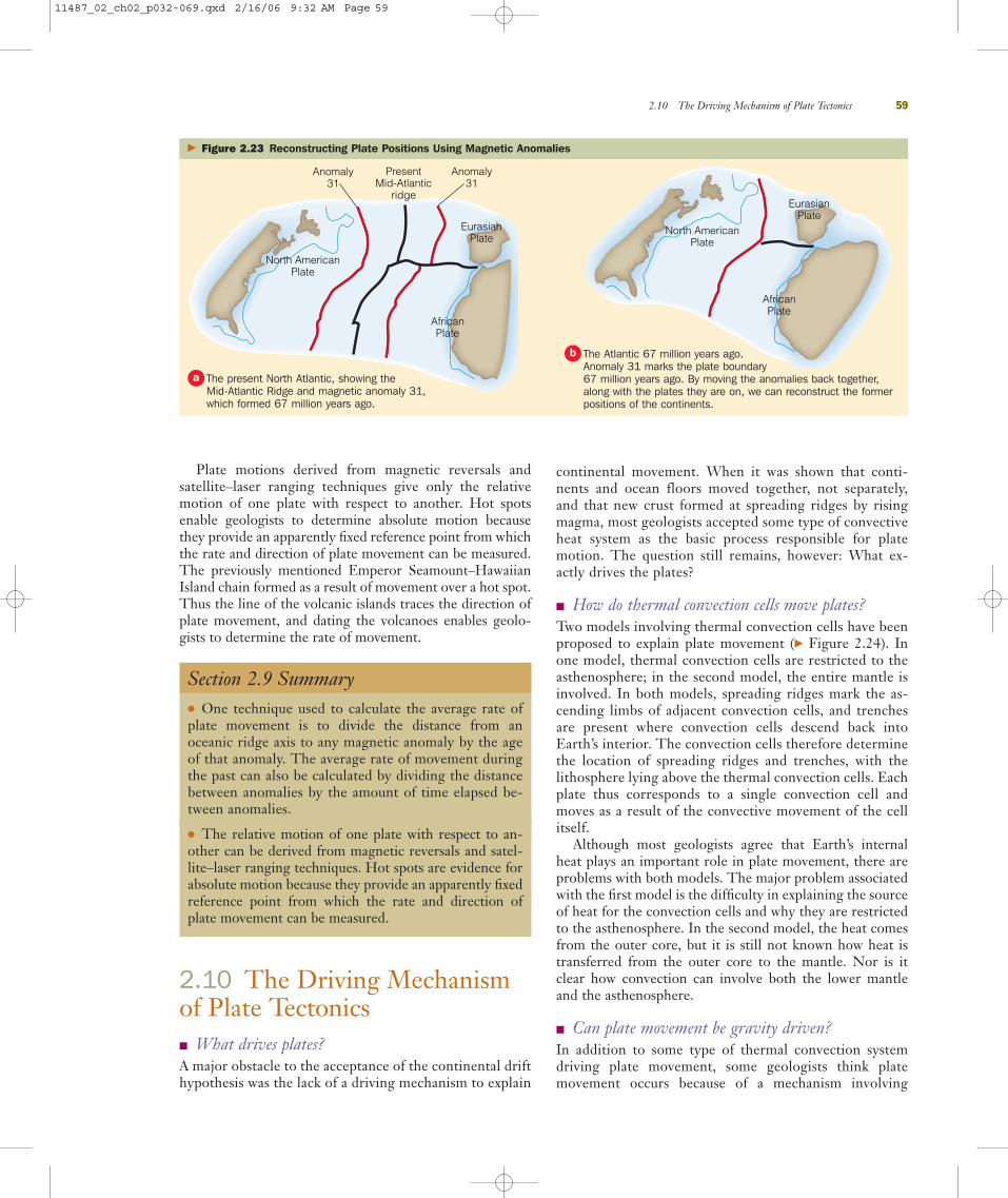
Plate motions derived from magnetic reversals andsatellite–laser ranging techniques give only the relativemotion of one plate with respect to another. Hot spotsenable geologists to determine absolute motion becausethey provide an apparently fixed reference point from whichthe rate and direction of plate movement can be measured.The previously mentioned Emperor Seamount–HawaiianIsland chain formed as a result of movement over a hot spot.Thus the line of the volcanic islands traces the direction ofplate movement, and dating the volcanoes enables geolo-gists to determine the rate of movement.
Section 2.9 Summary● One technique used to calculate the average rate ofplate movement is to divide the distance from anoceanic ridge axis to any magnetic anomaly by the ageof that anomaly. The average rate of movement duringthe past can also be calculated by dividing the distancebetween anomalies by the amount of time elapsed be-tween anomalies.
● The relative motion of one plate with respect to an-other can be derived from magnetic reversals and satel-lite–laser ranging techniques. Hot spots are evidence forabsolute motion because they provide an apparently fixedreference point from which the rate and direction ofplate movement can be measured.
2.10 The Driving Mechanismof Plate Tectonics� What drives plates?A major obstacle to the acceptance of the continental drifthypothesis was the lack of a driving mechanism to explain
continental movement. When it was shown that conti-nents and ocean floors moved together, not separately,and that new crust formed at spreading ridges by risingmagma, most geologists accepted some type of convectiveheat system as the basic process responsible for platemotion. The question still remains, however: What ex-actly drives the plates?
� How do thermal convection cells move plates?Two models involving thermal convection cells have beenproposed to explain plate movement (� Figure 2.24). Inone model, thermal convection cells are restricted to theasthenosphere; in the second model, the entire mantle isinvolved. In both models, spreading ridges mark the as-cending limbs of adjacent convection cells, and trenchesare present where convection cells descend back intoEarth’s interior. The convection cells therefore determinethe location of spreading ridges and trenches, with thelithosphere lying above the thermal convection cells. Eachplate thus corresponds to a single convection cell andmoves as a result of the convective movement of the cellitself.
Although most geologists agree that Earth’s internalheat plays an important role in plate movement, there areproblems with both models. The major problem associatedwith the first model is the difficulty in explaining the sourceof heat for the convection cells and why they are restrictedto the asthenosphere. In the second model, the heat comesfrom the outer core, but it is still not known how heat istransferred from the outer core to the mantle. Nor is itclear how convection can involve both the lower mantleand the asthenosphere.
� Can plate movement be gravity driven?In addition to some type of thermal convection systemdriving plate movement, some geologists think platemovement occurs because of a mechanism involving
2.10 The Driving Mechanism of Plate Tectonics 59
Anomaly31
North AmericanPlate
AfricanPlate
EurasianPlate
Anomaly31
PresentMid-Atlantic
ridge
North AmericanPlate
AfricanPlate
EurasianPlate
� Figure 2.23 Reconstructing Plate Positions Using Magnetic Anomalies
The present North Atlantic, showing the Mid-Atlantic Ridge and magnetic anomaly 31,which formed 67 million years ago.
a
The Atlantic 67 million years ago. Anomaly 31 marks the plate boundary 67 million years ago. By moving the anomalies back together,along with the plates they are on, we can reconstruct the formerpositions of the continents.
b
11487_02_ch02_p032-069.qxd 2/16/06 9:32 AM Page 59

“slab-pull” or “ridge-push,” both of which are gravity dri-ven but still dependent on thermal differences withinEarth (� Figure 2.25). In slab-pull, the subducting coldslab of lithosphere, being denser than the surroundingwarmer asthenosphere, pulls the rest of the plate along asit descends into the asthenosphere. As the lithospheremoves downward, there is a corresponding upward flowback into the spreading ridge.
Operating in conjunction with slab-pull is the ridge-pushmechanism. As a result of rising magma, the oceanic ridges
are higher than the surrounding oceanic crust. It is thoughtthat gravity pushes the oceanic lithosphere away from thehigher spreading ridges and toward the trenches.
Currently, geologists are fairly certain that some typeof convective system is involved in plate movement, butthe extent to which other mechanisms such as slab-pulland ridge-push are involved is still unresolved. However,the fact that plates have moved in the past and are stillmoving today has been proven beyond a doubt. And al-though a comprehensive theory of plate movement hasnot yet been developed, more and more of the pieces arefalling into place as geologists learn more about Earth’sinterior.
Section 2.10 Summary● Plates are thought to move by some type of thermalconvection system. In one model, thermal convectioncells are restricted to the asthenosphere, and in the sec-ond model, the entire mantle is involved. Both modelshave problems associated with heat transfer and thesource of heat.
● Some geologists think that, in addition to thermal con-vection, plate movement is primarily gravity driven, byeither “slab-pull” or “ridge-push.” In slab-pull, the sub-ducting, cold, dense lithosphere pulls the rest of the platealong as it descends into Earth’s interior. In ridge-push,gravity pushes the lithosphere away from the higherspreading ridges and toward the subduction trenches.
2.11 Plate Tectonics and the Distribution of Natural Resources� How does plate tectonic theory relate to the origin
and distribution of natural resources?Besides being responsible for the major features of Earth’scrust and influencing the distribution and evolution of the world’s biota, plate movements also affect the formationand distribution of some natural resources. The formationof many natural resources results from the interaction be-tween plates, and economically valuable concentrations ofsuch deposits are found associated with current and ancientplate boundaries. Consequently, geologists are using platetectonic theory in their search for petroleum and mineraldeposits and in explaining the occurrence of these naturalresources.
It is becoming increasingly clear that if we are to keep upwith the continuing demands of a global industrialized soci-ety, the application of plate tectonic theory to the origin anddistribution of natural resources is essential.
60 Chapter 2 Plate Tectonics: A Unifying Theory
C o r e
LowermantleHeat
source
Heatsource
Oceanic ridgeOceanic trench
Oceanic ridge
Lithosphere
Oceanic trench
Oceanic ridge
Asthenosphere
Oceanic trench
MantleHeat
source
Asthenosphere
Oceanic ridgeOceanic trench
Oceanic ridge
Lithosphere
Oceanic trench
Oceanic ridge
C o r e
Oceanic trench
� Active Figure 2.24 Thermal ConvectionCells as the Driving Force of Plate Movement Two modelsinvolving thermal convection cells have been proposed to explainplate movement.
In the first model, thermal convection cells are restricted to theasthenosphere.
a
In the second model, thermal convection cells involve the entiremantle.
b
11487_02_ch02_p032-069.qxd 2/16/06 9:32 AM Page 60

� What is the relationship between plate boundariesand various metallic mineral deposits?
Many metallic mineral deposits such as copper, gold, lead,silver, tin, and zinc are related to igneous and associated hy-drothermal (hot water) activity, so it is not surprising that aclose relationship exists between plate boundaries and theoccurrence of these valuable deposits.
The magma generated by partial melting of a subductingplate rises toward the surface, and as it cools, it precipitatesand concentrates various metallic ores. Many of the world’smajor metallic ore deposits are associated with convergentplate boundaries, including those in the Andes of South Amer-ica, the Coast Ranges and Rockies of North America, Japan,the Philippines, Russia, and a zone extending from the easternMediterranean region to Pakistan. In addition, the majority ofthe world’s gold is associated with sulfide deposits located atancient convergent plate boundaries in such areas as SouthAfrica, Canada, California, Alaska, Venezuela, Brazil, southernIndia, Russia, and western Australia.
The copper deposits of western North and South Americaare an excellent example of the relationship between conver-gent plate boundaries and the distribution, concentration,and exploitation of valuable metallic ores (� Figure 2.26a).The world’s largest copper deposits are found along this belt.The majority of the copper deposits in the Andes and thesouthwestern United States formed less than 60 million yearsago when oceanic plates were subducted under the North and South American plates. The rising magma and associated
hydrothermal fluids carried minute amounts of copper, whichwas originally widely disseminated but eventually becameconcentrated in the cracks and fractures of the surroundingandesites. These low-grade copper deposits contain from 0.2 to 2% copper and are extracted from large open-pit mines(� Figure 2.26b).
Divergent plate boundaries also yield valuable ore de-posits. The island of Cyprus in the Mediterranean is rich incopper and has been supplying all or part of the world’sneeds for the last 3000 years. The concentration of copperon Cyprus formed as a result of precipitation adjacent tohydrothermal vents along a divergent plate boundary. This
2.11 Plate Tectonics and the Distribution of Natural Resources 61
You are part of a mining exploration team that isexploring a promising and remote area of central
Asia. You know that former convergent and divergentplate boundaries are frequently sites of ore deposits.What evidence would you look for to determinewhether the area you’re exploring might be an ancientconvergent or divergent plate boundary? Is there any-thing you can do before visiting the area that mighthelp you to determine the geology of the area?
What Would You Do?What Would You Do?
Oceanicridge
TrenchSea level
Ridge push
Oceanic crust Slab pull
AsthenosphereConvectioncell movement
Rising magma
Upper mantle
� Geo-focus Figure 2.25 Plate Movement Resulting from Gravity-Driven Mechanisms Plate movement is also thoughtto result, at least partially, from gravity-driven “slab-pull” or “ridge-push” mechanisms. In slab-pull, the edge of the subducting plate descends intothe interior, and the rest of the plate is pulled downward. In ridge-push, rising magma pushes the oceanic ridges higher than the rest of the oceaniccrust. Gravity thus pushes the oceanic lithosphere away from the ridges and toward the trenches.
11487_02_ch02_p032-069.qxd 2/16/06 9:33 AM Page 61

deposit was brought to the surface when the copper-richseafloor collided with the European plate, warping theseafloor and forming Cyprus.
Studies indicate that minerals of such metals as copper,gold, iron, lead, silver, and zinc are currently forming assulfides in the Red Sea. The Red Sea is opening as a resultof plate divergence and represents the earliest stage in thegrowth of an ocean basin (� Figures 2.15c and 2.16b).
Section 2.11 Summary● The origin and distribution of many natural resourcesare related to the interaction between plates. Manymetallic ores form as a result of igneous and hydrother-mal activity related to the formation of magma alongdivergent and convergent plate boundaries.
62 Chapter 2 Plate Tectonics: A Unifying Theory
Copper deposits
Pacificplate
Nazcaplate
Caribbeanplate
North Americanplate
SouthAmericanplate
Cocosplate
Subduction zoneDivergent boundary
� Figure 2.26 Copper Deposits and Convergent Plate Boundaries
Cour
tesy
of R
. V. D
ietri
ch
Valuable copper deposits are located along the west coasts of Northand South America in association with convergent plate boundaries.The rising magma and associated hydrothermal activity resulting fromsubduction carried small amounts of copper, which became trappedand concentrated in the surrounding rocks through time.
a Bingham Mine in Utah is a huge open-pit copper mine with reservesestimated at 1.7 billion tons. More than 400,000 tons of rock areremoved for processing each day.
b
Review Workbook
ESSENTIAL QUESTIONS SUMMARY2.1 Introduction� Why should you know about plate tectonics?Plate tectonics affects all of us, whether in relation to the destruc-tion caused by volcanic eruptions and earthquakes, or politicallyand economically due to the formation and distribution of valu-able natural resources. Furthermore, plate tectonics is the unify-ing theory of geology, tying together many seemingly unrelatedgeologic phenomena and illustrating why Earth is a dynamicplanet of interacting subsystems and cycles.
2.2 Continental Drift� What were some early idea’s about Earth’s past geography?The idea that continents have moved in the past is not new andprobably goes back to the first maps, in which one could see thatthe east coast of South America looks like it fits into the westcoast of Africa.
� What is the continental drift hypothesis and who proposed it?Alfred Wegener originally proposed the continental drift hypoth-esis in 1912. He postulated that all landmasses were originallyunited into a supercontinent he named Pangaea. Pangaea con-
11487_02_ch02_p032-069.qxd 2/27/06 6:43 PM Page 62

sisted of a northern landmass called Laurasia and a southernlandmass called Gondwana. As Pangaea broke up, the variouscontinents moved to their present-day locations.
2.3 Evidence for Continental Drift� What is the evidence for continental drift?Wegener and others amassed a large amount of evidence in sup-port of continental drift. There is a close fit between continentsoff the coasts at a depth of about 2000 m. Marine, nonmarine,and glacial rock sequences of Pennsylvanian to Jurassic age arenearly identical on all the Gondwana continents, and the trendof several major mountain ranges produces a continuous moun-tain range when the continents are positioned next to eachother as they were during the formation of Pangaea. Glacial tills and striations on the bedrock beneath the till provide evi-dence of glaciation at the same time on all the Gondwana conti-nents, with South Africa located at the South Pole. Lastly, thedistribution of fossil plants (Glossopteris flora) and animals (thenonmarine reptile Mesosaurus in particular) provides convincingevidence that the southern continents were united during theLate Paleozoic Era.
2.4 Paleomagnetism and Polar Wandering� What is paleomagnetism?Paleomagnetism is the remanent magnetism in ancient rocksrecording the direction and intensity of Earth’s magnetic field atthe time of the rock’s formation.
� What is the Curie point and why is it important?The Curie point is the temperature at which iron-bearing miner-als gain their magnetism. It is important because as long as therock is not subsequently heated above the Curie point, it will pre-serve that remanent magnetism.
� How can the apparent wandering of the magnetic poles be bestexplained?
The best explanation for polar wandering, which is the apparentmovement of the magnetic poles through time, is that the mag-netic poles have remained near their present locations at the geo-graphic north and south poles and the continents have moved.When the continents are fitted together, the paleomagnetic datapoint to only one magnetic pole.
2.5 Magnetic Reversals and Seafloor Spreading� What evidence is there that Earth’s magnetic field has reversed in
the past?Earth’s present magnetic field is considered normal, that is, withthe north and south magnetic poles located approximately at thenorth and south geographic poles. At various times in the geo-logic past, Earth’s magnetic field has completely reversed. Theexistence of such magnetic reversals was discovered by dating anddetermining the orientation of the remanent magnetism in conti-nental lava flows.
� What is the theory of seafloor spreading, and how does it validatecontinental drift?
Harry Hess proposed the theory of seafloor spreading in 1962.He suggested that the seafloor separates at oceanic ridges, wherenew crust is formed by upwelling magma. As the magma cools,the newly formed oceanic crust moves laterally away from theridge. Thus continents and oceanic crust move together, negat-ing the need to explain how continents could plow throughoceanic crust.
� How was the theory of seafloor spreading confirmed?Seafloor spreading was confirmed by the discovery of magneticanomalies in the ocean crust that were both parallel to and sym-metric around the ocean ridges. The pattern of oceanic magneticanomalies matched the pattern of magnetic reversals alreadyknown from continental lava flows. Further evidence confirmingseafloor spreading came from the Deep Sea Drilling Project andthe age and thickness of the sediments overlying the oceaniccrust.
2.6 Plate Tectonics: A Unifying Theory� What are the main tenets of plate tectonic theory?According to plate tectonic theory, the rigid lithosphere, com-posed of oceanic and continental crust as well as the underlyingupper mantle, is divided into different-sized plates. The litho-sphere overlies the asthenosphere, and through some type ofheat-transfer system within the asthenosphere, moves the plates.As the plates move over the asthenosphere, they separate mostlyat oceanic ridges and collide and are subducted into Earth’sinterior at oceanic trenches.
� Why is plate tectonics a unifying theory of geology?The theory ties together many seemingly unrelated features andevents and shows how they are interrelated. Furthermore, it illus-trates the dynamic interactions between Earth’s various subsys-tems and cycles.
� What is the supercontinent cycle?The hypothesis put forth by J. Tuzo Wilson in the early 1970sposits a large-scale global cycle in which a supercontinent frag-ments to form various ocean basins that widen and then close,thus reassembling another supercontinent.
2.7 The Three Types of Plate Boundaries� What are the three types of plate boundaries?The three major types of plate boundaries are divergent, conver-gent, and transform.
� What are divergent boundaries?Divergent boundaries, also called spreading ridges, occur whereplates are separating and new oceanic lithosphere is forming.Whereas most divergent boundaries occur along the crests ofoceanic ridges, they are also present under continents during theearly stages of continental breakup.
� What features in the geologic record indicate ancient rifting?Characteristic features of ancient continental rifting include fault-ing, dikes, sills, lava flows, and thick sedimentary sequenceswithin rift valleys. Pillow lavas and associated deep-sea sedimentsare evidence of ancient spreading ridges.
� What are convergent boundaries?Convergent boundaries are places where two plates collide, andthe leading edge of one plate is subducted beneath the margin ofthe other plate. There are three types of convergent boundaries.Oceanic–oceanic boundaries are where two oceanic plates collide,with one plate subducted beneath the other and a volcanic islandarc forming on the nonsubducted plate, parallel to the oceanictrench where subduction is taking place. The volcanoes resultfrom rising magma produced by the partial melting of the sub-ducting plate. An oceanic–continental boundary is where anoceanic plate and a continental plate converge, with the denseroceanic plate being subducted under the continental plate. Just as with an oceanic–oceanic boundary, a chain of volcanoes forms
Review Workbook 63
11487_02_ch02_p032-069.qxd 2/16/06 9:33 AM Page 63

on the nonsubducted plate. A continental–continental boundaryoccurs when two continents approach each other and the oceanfloor separating them is eventually subducted, resulting in a colli-sion between the two continents. When the two continents col-lide, they are welded together to form an interior mountain chainalong a zone marking the former site of subduction.
� How can ancient subduction zones be recognized in the geologic record?Intensely deformed rocks, andesite lavas, and ophiolites are allevidence of ancient subduction zones, marking former conver-gent plate boundaries.
� What are transform boundaries?These are boundaries along which plates slide laterally past eachother along transform faults, which change one type of motionbetween plates into another type of motion.
2.8 Hot Spots: An Intraplate Feature� What are hot spots and what do they tell us about plate movement?A hot spot is the location on Earth’s surface where a stationarycolumn of magma, originating deep within the mantle, has slowlyrisen to the surface and formed a volcano. Because mantle plumesapparently remain stationary within the mantle while plates moveover them, the resulting hot spots leave a trail of extinct and pro-gressively older volcanoes that record the movement of the plate.
2.9 Plate Movement and Motion � How can the rate and direction of plate movement be determined?The average rate of plate movement is most commonly deter-mined by dividing the distance from an oceanic ridge axis to anymagnetic anomaly in the crust of the seafloor by the age of thatanomaly. Because magnetic anomalies are parallel and symmet-ric with respect to spreading ridges, the relative direction ofmovement of a plate is perpendicular to the spreading ridge.Satellite–laser ranging techniques are also used to determine therate of movement and relative motion of one plate with respectto another. Hot spots enable geologists to determine absolutemotion because they provide an apparently fixed reference pointfrom which the rate and direction of plate movement can bemeasured.
2.10 The Driving Mechanism of Plate Tectonics� What drives plates?Most geologists agree that some type of convective heat system isthe basic process responsible for plate motion.
� How do thermal convection cells move plates?Two models involving thermal convection cells have been pro-posed to explain plate movement. In one model, thermal cells arerestricted to the asthenosphere, whereas in the second model, theentire mantle is involved. Problems with both models involve thesource of heat for the convection cells and how heat is transferredfrom the outer core to the mantle.
� Can plate movement be gravity driven?Although they accept that some type of thermal convectionsystem is involved in driving plate movement, some geologiststhink a gravity-driven mechanism such as “slab-pull” or “ridge-push” plays a major role. Both mechanisms still depend onthermal differences within Earth, but slab-pull involves pullingthe plate behind a subducting cold slab of lithosphere, andridge-push involves gravity pushing the oceanic lithosphereaway from the higher spreading ridges and toward the subduc-tion trenches.
2.11 Plate Tectonics and the Distribution of NaturalResources� How does plate tectonic theory relate to the origin and distribution
of natural resources?The formation of many natural resources results from the inter-action between plates, and economically valuable concentrationsof such deposits are found associated with current and ancientplate boundaries.
� What is the relationship between plate boundaries and variousmetallic mineral deposits?
Many metallic mineral deposits are related to igneous and associ-ated hydrothermal activity, so it is not surprising that a close rela-tionship exists between plate boundaries and the occurrence ofthese valuable deposits. Many of the world’s major metallic oredeposits are associated with convergent plate boundaries. Diver-gent plate boundaries also yield valuable ore deposits.
64 Chapter 2 Plate Tectonics: A Unifying Theory
ESSENTIAL TERMS TO KNOWcontinental–continental plateboundary (p. 54)
continental drift (p. 35)
convergent plate boundary (p. 52)
Curie point (p. 40)
divergent plate boundary (p. 47)
Glossopteris flora (p. 38)
Gondwana (p. 34)
hot spot (p. 57)
Laurasia (p. 36)
magnetic anomaly (p. 43)
magnetic reversal (p. 41)
oceanic–continental plate boundary (p. 54)
oceanic–oceanic plate boundary (p. 52)
paleomagnetism (p. 40)
Pangaea (p. 35)
plate (p. 46)
plate tectonic theory (p. 34)
seafloor spreading (p. 41)
thermal convection cell (p. 42)
transform fault (p. 55)
transform plate boundary (p. 55)
11487_02_ch02_p032-069.qxd 2/16/06 9:33 AM Page 64

Review Workbook 65
REVIEW QUESTIONS1. What evidence convinced Wegener and others that conti-
nents must have moved in the past and at one time formed a supercontinent?
2. Why was the continental drift hypothesis proposed byWegener rejected by so many geologists for so long?
3. How did the theory of seafloor spreading, proposed by HarryHess in 1962, overcome the objections of those opposed tocontinental drift?
4. Explain how magnetic anomalies recorded in oceanic crust aswell as the sediments deposited on oceanic crust confirm theseafloor spreading theory.
5. Plate tectonic theory builds on the continental drifthypothesis and the theory of seafloor spreading. As such, it is a unifying theory of geology. Explain why it is a uni-fying theory.
6. Explain why such natural disasters as volcanic eruptions andearthquakes are associated with divergent and convergentplate boundaries.
7. What is the supercontinent cycle? What elements of conti-nental drift and seafloor spreading are embodied in the cycle?
8. Why is some type of thermal convection system thought to be the major force driving plate movement? How have“slab-pull” and “ridge-push,” both mainly gravity driven,modified a purely thermal convection model for platemovement?
9. What can hot spots tell us about the absolute direction ofplate movement?
10. In addition to the volcanic eruptions and earthquakes associ-ated with convergent and divergent plate boundaries, why arethese boundaries also associated with the formation and accu-mulation of various metallic ore deposits?
APPLY YOUR KNOWLEDGE1. Using the age for each of the Hawaiian Islands in Figure 2.22
and an atlas in which you can measure the distance betweenislands, calculate the average rate of movement per year forthe Pacific plate since each island formed. Is the average rateof movement the same for each island? Would you expect it tobe? Explain why it may not be.
2. Estimate the age of the seafloor crust and the age and thick-ness of the oldest sediment off the East Coast of NorthAmerica (e.g., Virginia). In so doing, refer to Figure 2.12 forthe ages and to the deep-sea sediment accumulation ratestated in this chapter.
3. If the movement along the San Andreas fault, which separatesthe Pacific plate from the North American plate, averages 5.5 cm per year, how long will it take before Los Angeles isopposite San Francisco?
4. Based on your knowledge of biology and the distribution of organisms throughout the world, how do you think platetectonics has affected this distribution both on land and in theoceans?
11487_02_ch02_p032-069.qxd 2/16/06 9:33 AM Page 65

66
Figure 1The Kuwaiti night skies were illuminated by 700 blazing oil wells set on fire by Iraqi troops during the 1991 Gulf War. The fires continued for nine months.
Reut
ers
New
Med
ia In
c./C
orbi
s
GEOLOGY MATTERS
It is certainly not surprising that oil and politics areclosely linked. The Iran–Iraq War of 1980–1989
and the Gulf War of 1990–1991 were both foughtover oil (� Figure 1). Indeed, many of the conflictsin the Middle East have had as their underlyingcause control of the vast deposits of petroleum inthe region. Most people, however, are not aware ofwhy there is so much oil in this part of the world.
Although large concentrations of petroleum occurin many areas of the world, more than 50% of all proven reserves are in the Persian Gulf region. It isinteresting, however, that this region did not becomea significant petroleum-producing area until the eco-nomic recovery following World War II (1939–1945).After the war, Western Europe and Japan in particularbecame dependent on Persian Gulf oil, and they stillrely heavily on this region for most of their supply. The
United States is also dependent on imports from the Persian Gulf but receives significant quantities ofpetroleum from other sources such as Mexico andVenezuela.
Why is so much oil in the Persian Gulf region? Theanswer lies in the ancient geography and plate move-ments of this region during the Mesozoic and Ceno-zoic eras. During the Mesozoic Era, and particularlythe Cretaceous Period when most of the petroleumformed, the Persian Gulf area was a broad marineshelf extending eastward from Africa. This continentalmargin lay near the equator where countless mi-croorganisms lived in the surface waters. The remainsof these organisms accumulated with the bottomsediments and were buried, beginning the complexprocess of petroleum generation and the formation ofsource beds in which the petroleum forms.
As a consequence of rifting in the Red Sea andGulf of Aden during the Cenozoic Era, the Arabianplate is moving northeast away from Africa and sub-ducting beneath Iran. As the sediments of the con-tinental margin were initially subducted, during theearly stages of collision between Arabia and Iran, theheating broke down the organic molecules and ledto the formation of petroleum. The tilting of theArabian block to the northeast allowed the newlyformed petroleum to migrate upward into the interiorof the Arabian plate. The continued subduction andcollision with Iran folded the rocks, creating traps forpetroleum to accumulate, such that the vast areasouth of the collision zone (know as the Zagrossuture) is a major oil-producing region.
Oil, Plate Tectonics, and PoliticsGeologyIN FOCUS
11487_02_ch02_p032-069.qxd 2/16/06 9:33 AM Page 66

67
Imagine visiting a castle in Devonshire, England,or Glasgow, Scotland, and noticing that the same
rocks used in the construction of those castles can be seen in the Catskill Mountains of New York(� Figure 1). Whereas most people who visit cas-tles in Great Britain and elsewhere in Europe arelearning about the history of the castles—when theywere built, why they were built, who lived in them,and other historical facts—geologists frequently arelooking at the rocks that make up the walls of acastle and trying to determine what type of rock itis, how old it is, and anything else they can learnabout it.
During the Devonian Period (416 to 359 millionyears ago), the North American continent and whatis now Europe were moving toward each other along
an oceanic–continental convergent plate boundary.As movement along this boundary continued, theocean basin separating these landmasses shrunkuntil the two continents collided in what is known as the Acadian Orogeny. This mountain-buildingepisode formed a large mountain range. Just as ishappening today, those mountains began weather-ing and their eroded sediments were carried bystreams and deposited as large deltas in the shal-low seas adjacent to the mountains. The sedimentsdeposited in what is now New York are referred toby geologists as the Catskill Delta. The counterpartin Great Britain is known as the Old Red Sandstone.These sediments were deposited in the same envi-ronment and reflect the conditions at the time ofdeposition.
Later during the Mesozoic Era (251 to 66 millionyears ago), as the supercontinent Pangaea brokeapart along divergent plate boundaries, the AtlanticOcean basin formed, separating North America fromEurope. Even though the Devonian rocks of the pre-sent-day Catskill Mountains in New York are sepa-rated by several thousand kilometers from the OldRed Sandstone rocks of Great Britain, they wereformed at the same time and deposited in the sameenvironment hundreds of millions of years ago. Thatis why they have the same red color and composi-tion and contain many of the same fossils.
So, the next time you see someone closely in-specting the rocks of a castle wall, there is a goodchance that person is a geologist or someone, likeyourself, who took a geology course.
Figure 1Remains of Goodrich Castle in Herefordshire, England, dated to the period between 1160 and 1270. Goodrich Castle is one of many castles built from rocks quarried from the Old Red Sandstone, a Devonian-age formation. Identical red sandstone is found in the Catskill Mountains of New York. It too has been used as a building stone for many structures in theNew York area.
Shay
ne M
cGui
re/M
yth
and
Lege
nds
Phot
ogra
phy
GEOLOGY MATTERS
A Man’s Home Is His CastleGeologyIN UNEXPECTED PLACES
11487_02_ch02_p032-069.qxd 2/16/06 9:33 AM Page 67

68
The Struggle toward ScientificProgress
Progress in science isn’t made easily. It would benice if a scientist could come up with a good
idea and then quickly convince other scientists of itsmerits, but in fact science is more like one longargument.
When Alfred Wegener proposed his idea of con-tinental drift, it was met by derision from most geol-ogists. They pointed out that Wegener had no con-vincing explanation for how continents moved acrossentire ocean basins. That was indeed a great weak-ness in his story, and Wegener’s crit-ics capitalized on it. But it wasn’t theonly issue that they focused on in theirattack on Wegener’s ideas.
As you read in this chapter, EdwardSuess pointed to fossil evidence ofsimilar ancient animals and plantsapparently separated by great dis-tances across oceans. Suess thought
that land bridges had linked what are now differentcontinents. Wegener, however, took the fossils ofSuess and others and argued that the rocks in whichthe fossils were embedded must have been physi-cally together in one ancient supercontinent (� Fig-ure 1). Unfortunately, Wegener was a meteorologistby training, not a paleontologist, and he made mis-takes about the details of the fossil evidence he re-lied on in his argument. Not surprisingly, fossil ex-perts denounced his work because of those errors.
Wegener also thought that continental move-ment was quite rapid, much faster than anythingwe understand today in plate tectonic theory. In-deed, Wegener thought that Greenland was movingaway from Europe at speeds up to meters peryear—and he died while in Greenland trying tomeasure that amazing rate of movement. Whennews of Wegener’s disappearance and presumeddeath in Greenland reached the civilized world, fewgeologists mourned his passing. The arguments
Wegener had spawned had beenvociferous even by the standards ofscientific disputes.
Progress in science isn’t easy, andthe arguments that ultimately drivescience forward are often unpleasant.In the case of Alfred Wegener, it isnow clear that his insights outweighedhis errors.
GEOLOGY MATTERS
GeologyAND CULTURAL CONNECTIONS
Figure 1Mesosaurus, a Permian-aged freshwater reptile whose fossil remains are found in Braziland South Africa, indicating these two continents were joined at the end of thePaleozoic Era.
Reed
Wic
ande
r
11487_02_ch02_p032-069.qxd 2/16/06 9:33 AM Page 68
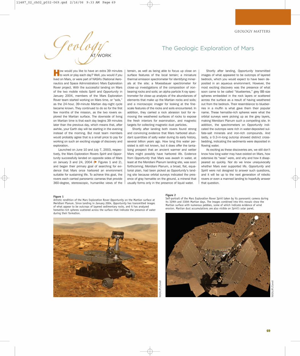
69
How would you like to have an extra 39 minutesto work or play each day? Well, you would if you
lived on Mars, or were part of NASA’s (National Aero-nautics and Space Administration) Mars ExplorationRover project. With the successful landing on Marsof the two mobile robots Spirit and Opportunity inJanuary 2004, members of the Mars ExplorationRover team started working on Mars time, or “sols,”as the 24-hour, 39-minute Martian day-night cyclebecame known. They continued to do so for the firstfew months of the mission, as the two rovers ex-plored the Martian surface. The downside of livingon Martian time is that each day begins 39 minuteslater than the previous day, which means that, afterawhile, your Earth day will be starting in the eveninginstead of the morning. But most team memberswould probably agree that is a small price to pay forworking on such an exciting voyage of discovery andexploration.
Launched on June 10 and July 7, 2003, respec-tively, the Mars Exploration Rovers Spirit and Oppor-
tunity successfully landed on opposite sides of Marson January 3 and 24, 2004 (� Figures 1 and 2),and began their primary goal of searching for evi-dence that Mars once harbored an environmentsuitable for sustaining life. To achieve this goal, therovers each carried panoramic cameras that provide360-degree, stereoscopic, humanlike views of the
terrain, as well as being able to focus up close onsurface features of the local terrain; a miniaturethermal emission spectrometer for identifying miner-als at the site; a Moessbauer spectrometer forclose-up investigations of the composition of iron-bearing rocks and soils; an alpha particle X-ray spec-trometer for close-up analysis of the abundances ofelements that make up the Martian rocks and soils;and a microscopic imager for looking at the fine-scale features of the rocks and soils encountered. Inaddition, they carried a rock abrasion tool for re-moving the weathered surfaces of rocks to exposethe fresh interiors for examination, and magnetictargets for collecting magnetic dust particles.
Shortly after landing both rovers found strongand convincing evidence that Mars harbored abun-dant quantities of salty water during its early history,several billion years ago. How long this water per-sisted is still not known, but it does offer the tanta-lizing prospect that an ancient warmer and wetterMars might possibly have harbored life. Evidencefrom Opportunity that Mars was awash in water, atleast at the Meridiani Planum landing site, was soonforthcoming. Meridiani Planum, a broad, flat, equa-torial plain, had been picked as Opportunity’s land-ing site because orbital surveys indicated the pres-ence of gray hematite on the ground, a mineral thatusually forms only in the presence of liquid water.
Shortly after landing, Opportunity transmittedimages of what appeared to be outcrops of layeredbedrock, which you would expect to have been de-posited in an aqueous environment. However, themost exciting discovery was the presence of whatsoon came to be called “blueberries,” grey BB-sizespheres embedded in the rock layers or scatteredacross the surface as a result of having weatheredout from the bedrock. Their resemblance to blueber-ries in a muffin is what gave them their popularname. These hematite-rich spheres were what theorbital surveys were picking up as the grey layers,making Meridiani Planum such a compelling site. Inaddition, the spectrometers on Opportunity indi-cated the outcrops were rich in water-deposited sul-fate-salt minerals and iron-rich compounds. Andlastly, a 0.3-m-long outcrop showed distinct cross-bedding, indicating the sediments were deposited inflowing water.
As exciting as these discoveries are, we still don’tknow how long water may have existed on Mars, howextensive its “seas” were, and why and how it disap-peared so quickly. Nor do we know unequivocallywhether Mars ever supported life. Opportunity andSpirit were not designed to answer such questions,and it will be up to the next generation of roboticrovers or even a manned landing to hopefully answerthat question.
GEOLOGY MATTERS
The Geologic Exploration of MarsGeologyAT WORK
Figure 1Artistic rendition of the Mars Exploration Rover Opportunity on the Martian surface atMeridiani Planum. Since landing in January 2004, Opportunity has transmitted imagesof what appear to be outcrops of layered sedimentary rocks, and it has analyzedhematite-rich spheres scattered across the surface that indicate the presence of waterduring their formation.
NAS
A/JP
L/Co
rnel
l
Figure 2Self-portrait of the Mars Exploration Rover Spirit taken by its panoramic camera duringits 329th and 330th Martian days. The images combined into this mosaic show theMartian surface with numerous pebbles, some of which indicate evidence of winderosion. Martian dust accumulations are also visible on Spirit’s solar panel.
NAS
A/JP
L/Co
rnel
l
11487_02_ch02_p032-069.qxd 2/16/06 9:33 AM Page 69