
Chapter 17.16 — Beachlands Village: New Avenues 17.16.1 ... · being 20m wide. This provides...
60
Manukau Operative District Plan 2002 Chapter 17.16 — Beachlands Village: New Avenues Page 1 Chapter 17.16 — Beachlands Village: New Avenues 17.16.1 INTRODUCTION 17.16.1.1 Area Description Beachlands is a rural and coastal village located east of the Manukau City urban area adjoining the Tamaki Strait coastline. Beachlands Village: New Avenues (BVNA) is an extension of the Beachlands village (see BVNA Structure Plan Figure 17.16.1). It covers approximately 122 hectares of land lying to the south of the existing Beachlands village, and bounded by Jack Lachlan Drive to the south, Beachlands and Karaka Roads to the north and Whitford-Maraetai Road to the east. In addition to the Beachlands village itself, the wider geographical context of BVNA includes significant natural, cultural, heritage, public open space and social resources, including: • extensive coastal views overlooking the Hauraki Gulf, including long-range views to Rangitoto, Motukaraka Island and Auckland City. • significant coastal reserves including Omana Regional Park, Duder Regional Park, Motukaraka, and Te Puru Reserve. • the first landing place in the Waitemata Harbour for the Tainui canoe in the 14 th century. • Omana Regional Park, which was occupied by Ngai Tai Umupuia for many generations and included the O Manawatere pa. • Formosa Golf Resort, which includes a 50 villa hotel, clubhouse facilities and a sports complex. • the Maraetai rural and coastal village • the Whitford Rural area • Pine Harbour Marina, which provides a commuter ferry service with a 35 minute journey to the Auckland CBD. BVNA adjoins older residential parts of existing Beachlands to the north and the much newer Pine Harbour development to the west. Whitford Rural zoned areas lie to the east and south. The Formosa Golf Course occupies the land to the south of Jack Lachlan Drive. The Beachlands Maraetai Pony Club occupies Council reserve land to the east. Otherwise, the wider Whitford Rural Area has rural uses and a rural character. BVNA will develop from its traditional appearance as a rural countryside area, with pockets of residential development. The area is linear in shape, tapering slightly in a westerly direction from Whitford – Maraetai Road towards Pine Harbour Marina. The topography of the area, including the ridgeline along the northern side of the area, and the gentle fall away to the west contributes to this area being relatively self – contained within the context of its surroundings. In terms of natural elements, BVNA is bisected by a perennial stream which traverses the site in parallel with the southern boundary in westward flows towards Pine Harbour Marina. The upper branches of the stream are partly vegetated with mixed native trees, while the lower reaches have been dammed to create a linear pond that feeds into a concrete channel through to Pine Harbour Marina. A line of mature conifer trees to the north of the stream partly conceal the western boundary of BVNA from Pine Harbour Marina. Jack Lachlan Drive, at the Whitford – Maraetai Road end, is enclosed by linear shelter belt planting. The prominent corridor created by this vegetation has views westwards from the Whitford – Maraetai Road, and assists in screening household units located along the eastern boundary of BVNA.
Transcript of Chapter 17.16 — Beachlands Village: New Avenues 17.16.1 ... · being 20m wide. This provides...

Chapter 17.16 — Beachlands Village: New Avenues Page 1
Chapter 17.16 — Beachlands Village: New Avenues
17.16.1 INTRODUCTION
17.16.1.1 Area Description
Beachlands is a rural and coastal village located east of the Manukau City urban area adjoining the Tamaki Strait coastline. Beachlands Village: New Avenues (BVNA) is an extension of the Beachlands village (see BVNA Structure Plan Figure 17.16.1). It covers approximately 122 hectares of land lying to the south of the existing Beachlands village, and bounded by Jack Lachlan Drive to the south, Beachlands and Karaka Roads to the north and Whitford-Maraetai Road to the east.
In addition to the Beachlands village itself, the wider geographical context of BVNA includes significant natural, cultural, heritage, public open space and social resources, including:
• extensive coastal views overlooking the Hauraki Gulf, including long-range views to Rangitoto, Motukaraka Island and Auckland City.
• significant coastal reserves including Omana Regional Park, Duder Regional Park, Motukaraka, and Te Puru Reserve.
• the first landing place in the Waitemata Harbour for the Tainui canoe in the 14th century.
• Omana Regional Park, which was occupied by Ngai Tai Umupuia for many generations and included the O Manawatere pa.
• Formosa Golf Resort, which includes a 50 villa hotel, clubhouse facilities and a sports complex.
• the Maraetai rural and coastal village
• the Whitford Rural area
• Pine Harbour Marina, which provides a commuter ferry service with a 35 minute journey to the Auckland CBD.
BVNA adjoins older residential parts of existing Beachlands to the north and the much newer Pine Harbour development to the west. Whitford Rural zoned areas lie to the east and south. The Formosa Golf Course occupies the land to the south of Jack Lachlan Drive. The Beachlands Maraetai Pony Club occupies Council reserve land to the east. Otherwise, the wider Whitford Rural Area has rural uses and a rural character.
BVNA will develop from its traditional appearance as a rural countryside area, with pockets of residential development. The area is linear in shape, tapering slightly in a westerly direction from Whitford – Maraetai Road towards Pine Harbour Marina. The topography of the area, including the ridgeline along the northern side of the area, and the gentle fall away to the west contributes to this area being relatively self – contained within the context of its surroundings. In terms of natural elements, BVNA is bisected by a perennial stream which traverses the site in parallel with the southern boundary in westward flows towards Pine Harbour Marina. The upper branches of the stream are partly vegetated with mixed native trees, while the lower reaches have been dammed to create a linear pond that feeds into a concrete channel through to Pine Harbour Marina. A line of mature conifer trees to the north of the stream partly conceal the western boundary of BVNA from Pine Harbour Marina. Jack Lachlan Drive, at the Whitford – Maraetai Road end, is enclosed by linear shelter belt planting. The prominent corridor created by this vegetation has views westwards from the Whitford – Maraetai Road, and assists in screening household units located along the eastern boundary of BVNA.
Manukau Operative District Plan 2002

Chapter 17.16 — Beachlands Village: New Avenues Page 2
The rural pastoral character of BVNA will change over time as the area develops.
17.16.2 RESOURCE MANAGEMENT ISSUES
The following issues are specific to Beachlands Village: New Avenues (BVNA)
Issue17.16.2.1 The wider planning framework for BVNA needs to have regard to social and economic
well being of the city as a whole. It must also give effect to the Auckland Regional Policy Statement framework as it relates to the management of urban growth, including expansion of a rural and coastal village.
The city’s metropolitan urban area, i.e. that area within the Metropolitan Urban Limits, has come under increasing pressure for compact development conducive to the efficient utilisation of the land resource and public infrastructure (including the need for integration of land use with transport infrastructure). This has generally meant a drive towards smaller site sizes and a corresponding decline in the provision of larger site sizes, which continue to be sought by a significant sector of the community. Increasingly, it is expected that people will look to rural and coastal villages to provide a lower density living environment. Beachlands is well placed to respond to this element of social wellbeing.
The Auckland Regional Policy Statement (ARPS) recognises that rural towns and villages are an important focus for accommodating growth in rural parts of the region. The strategic policy framework of the ARPS provides for limited extensions to the limits of existing rural and coastal villages, subject to a range of criteria (see Policy 2.6.2.2 of the ARPS), and a “structure planned” approach (see Chapter 2, Appendix A of the ARPS).
An integrated structure planning approach has been undertaken involving a comprehensive consideration of how best to provide for those seeking a rural-type living environment and how best to manage this area having regard to the wider context of the entire rural area from Whitford Village through to Beachlands / Maraetai. One of the outcomes of this process has been to take a conservative approach to the provision made for countryside living subdivision and development in the Whitford Rural area, and to favour development of a low density residential environment within an expanded Beachlands village – the BVNA area.
Issue17.16.2.2 BVNA adjoins the existing Beachlands rural and coastal village. Beachlands has
special qualities that make it unique, and an attractive place to live. BVNA needs to be developed in such a way as will integrate with the pattern and character of that village rather than appearing as a distinct community more typical of a suburban environment.
Beachlands village was laid out in the 1920s as a “Marine Garden Suburb”, and it originally functioned as a holiday destination. The village has developed with a character strongly defined by:
(a) A rectangular grid roading layout
The typically rectangular grid in Beachlands village contributes significantly to the character and appearance of the area. Roads are wide with generous verges, long and straight, flowing with the topography. The avenues running east/west are the longest, running parallel with the ridge, and gently undulating along their length. Roads running north/south are shorter. In the case of Shelly Bay Road there is a wide view of the sea beyond. The shallow slope of the topography elsewhere means that coastal views are generally not available.
Manukau Operative District Plan 2002

Chapter 17.16 — Beachlands Village: New Avenues Page 3
The rectangular grid layout results in either the front or rear elevation of a significant number of household units in Beachlands enjoying a northerly orientation. This maximises their potential to benefit from solar gain.
(b) A street character having an informal and natural appearance, graduating over time to a more formal appearance
Streets in Beachlands often have open swales on either side with no kerbs, and an absence of formed footpaths and formal street planting. The front boundary of sites typically consists of trees, hedges and other planting and trees in the front yard area of adjoining sites. Many sites have low, open timber fences, often with planting behind and sometimes to the front. These streets appear more spacious and reflect the historic character of Beachlands as a beachside village.
The Council has a programme in place that will in time lead to kerbs and footpaths being constructed over the whole of the Beachlands area. This will gradually alter the present informal character to a more formal one.
(c) A “green” landscape
The spacious appearance of streets is achieved by most plants and trees being located within private sites rather than the road verge area. The planting within front yards and along front boundaries gives the streets an informal character. Overall, the streetscape is dominated by this planting, and generous rear yard areas have also allowed significant areas of trees to become established. These can be seen when looking directly into sections, and play an important role in enhancing the planted character of the area.
(d) Low density residential development.
The minimum site size requirement in Beachlands is 700m2, although most site sizes are between 950m2 and 1050m2. The width of sections is very uniform, with most sites being 20m wide. This provides sufficient width to allow space between adjacent buildings and emphasises the sense of spaciousness of the area.
(e) Commercial, business and community areas servicing the community
A convenience shopping area is clustered around the intersection of Wakelin Road and Third View Avenue. This business area includes a food market, video rental, a bakery, café, lotto / post shop, a liquor shop, two real estate agents, butcher, diary, a café and a hair salon. Given the limited nature of services provided in this business area the Beachlands resident population is required to meet a significant proportion of its shopping and other commercial service needs outside of the settlement (for instance at Howick and Botany). The business area also provides a number of community services, including a police station, community library, Beachlands Hall, club rooms and a church. A primary school is located on Bell Road. Other community facilities also include Te Puru Community Centre and associated facilities on Te Puru Reserve.
The existing business area is unable to develop in a way that can sustain the existing and growing community given the constraints of the surrounding residential land and limited developable business zoned land. A new business area is therefore required to meet the retail and other needs of the existing and growing community.
(f) Significant areas of Public Open Space
There are sizeable areas of Public Open Space within the original village. Te Puru Park is a large active reserve. There are large coastal reserves, including developing reserves in the Spinnaker Bay area. Within the village itself some areas of Public Open
Manukau Operative District Plan 2002

Chapter 17.16 — Beachlands Village: New Avenues Page 4
Space are contained within the grid/section pattern. Others are located adjacent to the cliff top or adjoin areas of esplanade reserve.
Approaches to some of the recent subdivisions in Beachlands have typically had an emphasis on cul-de sacs and irregular sites that are of a different proportion and shape to that typical in the older parts of Beachlands. This has resulted in some buildings in these new subdivisions appearing too large for the sites, leaving little space in the front, side and rear for planting to be accommodated that would allow the new areas to have the same spacious and vegetated character as the original village. Such development is more typical of suburban Auckland rather than reflecting the rural and coastal village character of Beachlands. In many respects, these subdivisions have missed the opportunity to create quality environments that are a modern interpretation of the original village.
BVNA covers a substantial area (122 hectares) that has the potential to affect the character of the Beachlands village as a whole. While some opportunities exist for innovative development subject to comprehensive planning and design, the elements contributing to the character of the existing Beachlands village as described above need to be recognised and where possible reflected in BVNA. The basic street pattern is a critical element in achieving this integration. It is important that a required roading pattern in BVNA reflects that in existing Beachlands, including through appropriate road connections. The pedestrian and reserve network should be integrated. Site sizes and shapes, and future building development should be carried out in a way that integrates with the existing village.
Special consideration therefore needs to be given to the development in BVNA to establish a design framework which achieves a rural and coastal village character and which is sustainable, safe, vibrant and efficient. Sites and development in BVNA cannot be designed in isolation. Quality urban design needs to respond to the natural and physical environment, protecting and enhancing those environmental values important to the character, amenity and identity of the Beachlands community.
Examples of urban design matters that are warranted in BVNA include;
• Roading layout, public spaces, configuration and location of sites and buildings and a built form consistent with the established character of Beachlands, contributing to a vibrant, liveable and attractive environment, with a sense of place and identity.
• Opportunities provided for planting in the front and rear to sites to enable a green canopied landscape, with development set amongst significant vegetation on large sections.
• An urban environment which has a logical permeable and safe structure of connected routes for all modes of transport, including walking and cycling.
• Public transport, roading, cycling and walking networks integrated with each other and the land uses they serve.
• Long term protection of public open space, and enhancement in the quality, quantity and distribution of local open space.
• Natural features and their relationships with built elements are recognised and protected, and, where appropriate enhanced.
• A positive contribution to the environmental health of streams, the harbours and their catchments including through improved stormwater and wastewater management.
• Public access to and along the streams and coastal and foreshore environments is protected and, and where possible enhanced.
• Conflicts between incompatible land uses are avoided, remedied or mitigated.
Manukau Operative District Plan 2002

Chapter 17.16 — Beachlands Village: New Avenues Page 5
Issue17.16.2.3 Development in BVNA will create demands on infrastructure, which has limited
capacity for new development, in particular roads, wastewater and water supply.
The main roading access to Beachlands is via the Whitford-Maraetai Road, which is a two lane sealed road. The development of the BVNA for residential development will increase traffic on the rural roading system leading into this area. The Whitford Roads Strategy Study (2004) has identified the future upgrading requirements for the roading network to address operational and safety issues. One of the recommendations of this Strategy is to ultimately increase the width of Whitford – Maraetai Road to four lanes when it becomes necessary to accommodate increases in traffic volumes and to provide adequate standards of safety along this road. The BVNA Integrated Transport Assessment has confirmed that upgrading of Whitford-Maraetai Road to four lanes will be sufficient to meet the expected traffic demand generated by the BVNA. Council has designated the land required in order to upgrade the Whitford – Maraetai Road. Funding has also been provided in the Long Term Council Community Plan (LTCCP) to progressively upgrade the Whitford – Maraetai Road on an as and when required basis.
The intersection of Whitford-Maraetai Road and Jack Lachlan Drive will require upgrading as a result of the development within the BVNA. The timing of this upgrade is important in ensuring that there are no adverse effects on the rural roading system leading into BVNA.
It is important that the internal roading pattern of the BVNA provides linkages to existing Beachlands and to Pine Harbour Marina which is a recognised public transport node.
The main internal roads for BVNA are shown on BVNA Structure Plan Figure 17.16.1. These roads will provide access into Beachlands and Pine Harbour Marina. The desirable outcome for the internal roading pattern for BVNA is to reflect the rectilinear grid roading pattern of the existing Beachlands. The timing and development of the key internal roading linkages, such as Road 1, Road 2 and Ninth View Avenue in the BVNA Structure Plan is critical in ensuring connectivity between BVNA, Pine Harbour Marina and Beachlands.
The Beachlands and Maraetai villages are currently serviced by the Beachlands – Maraetai Wastewater Treatment Plant, which has been upgraded to service 10,000 people. The Plant is designed to enable an expansion of another 5000 population via the addition of another module.
Provision needs to be made within the BVNA to provide wastewater connections to the Beachlands – Maraetai Wastewater Treatment Plant.
Beachlands does not have a reticulated water supply. Existing water supply is through individual water tanks replenished by roof water and supplemented by truck deliveries. There is a need to ensure there is sustainable supply of water in BVNA.
The timing, provision and development of physical infrastructure is an important component in managing the overall environmental effects associated with subdivision, use and development of land within BVNA. Uncoordinated and inappropriately designed development within BVNA has the potential to lead to the inefficient provision of infrastructure, including roading, wastewater network, and the supply of potable water. The water for potable water supplies can be sourced from either the groundwater aquifers or rain water runoff from roofs.
Issue17.16.2.4 Development in BVNA will affect existing drainage patterns, create greater rates of
stormwater runoff and affect the quality of stormwater.
BVNA contains existing watercourses that represent an important part of the natural resource that should be retained and enhanced as the basis for the design of stormwater infrastructure in BVNA.
The earthworks activities that will be required for the establishment of development within BVNA have the potential to result in adverse impacts on the sensitive receiving environment, including Pine Harbour Marina and the coastal marine area. It is therefore important to ensure that appropriate sediment control
Manukau Operative District Plan 2002

Chapter 17.16 — Beachlands Village: New Avenues Page 6
facilities are established and maintained as part of all earthworks during the bulk earthworks stage and building stage.
Development of greenfields sites for residential purposes increases impermeable areas and reduces the ability of the land to dispose of stormwater to ground through traditional soakage methods. Soil conditions in Beachlands have poor soakage. Without appropriate treatment, stormwater discharges from site development and from roads and driveways will increase contaminants in local waterways and contribute to pollution in the sensitive receiving environment, including the receiving environment at Pine Harbour Marina.
The Network Discharge Consent for BVNA will set out a strategy and necessary works required for the management of the public stormwater system.
Issue17.16.2.5 Urban development in BVNA has the potential to adversely affect the rural character
and amenity values of the surrounding rural environment.
BVNA is bounded by the Whitford Rural Area on the east and south sides. Residential development in BVNA will change the character of this site from rural to low density residential. Special consideration needs to be given to managing the adverse effects of the proposed residential development on the surrounding rural area, and in particular at the eastern and southern boundary of the BVNA Structure Plan.
Whitford – Maraetai Road is the main road traversing through the Whitford Rural Area, from Whitford Village through to Beachlands and Maraetai. For both residents and visitors a significant aspect of the appreciation of the landscape character and rural amenity comes through the vistas and views obtained while travelling along this route. It is important to manage the interface issues between the residential development proposed along the eastern boundary of the BVNA Structure Plan and Whitford – Maraetai Road. The provision of a “soft” landscape edge along this boundary is necessary to maintain the rural character of the adjacent pastoral land use and the form of the existing Beachlands village and the wider rural landscape.
Jack Lachlan Drive forms the southern boundary of the BVNA Structure Plan. This boundary needs to be developed and maintained as a defined and defensible edge to the new boundary of the Beachlands village, to ensure a clear differentiation between the urban and rural uses.
Issue17.16.2.6 Adequate and appropriate provision of public open space is necessary to establish
and maintain landscape character, amenity values, rural and coastal village character, and the physical health, social and cultural wellbeing of the BVNA and wider community.
Public open space is land held in public ownership for the purpose of providing public access to open land, foreshore, rivers and streams, for the protection of biodiversity and important landscapes, and for recreational opportunities. Inadequate and inappropriate provision of public open space in BVNA can result in a lack of, or restricted access to the adjoining coastal environment. The provision of public open space network that optimises accessibility to the Beachlands village, community facilities, the coastal environment and Pine Harbour Marina is an issue that warrants special consideration within BVNA.
Adequate provision for a connected public open space network is important to enhance natural features, to provide an open space balance to built development and for the recreation and enjoyment of local residents. Uncoordinated and inadequate provision of public open space and the inappropriate relationship of structures and activities to the “public realm” can have adverse effects on amenity values, including attractiveness, function and safety of the area. Public open space can become less used and possibly unsafe if development and subdivision turns it’s back on the open space rather than facing onto the open space and providing good public access to these areas.
Manukau Operative District Plan 2002

Chapter 17.16 — Beachlands Village: New Avenues Page 7
Issue17.16.2.7 Public perception of safety and actual safety (personal and otherwise) is affected by
subdivision design, public places and the interfaces between them.
The design of public places can have significant effects on the safety and perceived safety of those areas. Establishing minimum standards for safety will assist in making BVNA a more vibrant environment and a more pleasant place to live in and visit.
17.16.3 OBJECTIVES
The BVNA Objectives shall apply to all zones in BVNA.
In respect of the Public Open Space areas, the Objectives referred to in Chapter 15 Public Open Space shall also apply.
In relation to the subdivision and development of land the Objectives referred to in Chapter 8 Transportation and Chapter 9 - Land Modification, Development and Subdivision shall also apply.
Objective17.16.3.1 To contribute towards meeting the district’s urban growth needs by establishing a low
density residential zone as an extension to the Beachlands village.
(This objective relates to Issue 17.16.2.1)
Objective17.16.3.2 To establish a new boundary for an expanded Beachlands village that provides a
defined and defensible long term differentiation between urban and rural areas.
(This objective relates to Issue 17.16.2.1 and 17.16.2.5)
Objective17.16.3.3 To establish, maintain and enhance amenity values of neighbourhoods and sites in a
manner that adopts sound principles of urban design, including an urban form that complements, enhances and integrates with the character and developed pattern of the existing Beachlands village, and a place with a rural and coastal village character that people want to live in and visit.
(This objective relates to Issue 17.16.2.2)
Objective17.16.3.4 To establish and maintain an open, spacious rural and coastal village character.
(This objective relates to Issue 17.16.2.2 and 17.16.2.6)
Objective17.16.3.5 To recognise, protect and enhance the natural values of watercourses, ponds, wetland
margins and their surrounds, including their landform, ecology, landscape and open space qualities.
(This objective relates to Issue 17.16.2.4)
Objective17.16.3.6 To provide adequate and appropriate land for public open space and ensure that these
areas are treated as integrated features in any development.
(This objective relates to Issue 17.16.2.6)
Manukau Operative District Plan 2002

Chapter 17.16 — Beachlands Village: New Avenues Page 8
Objective17.16.3.7 To achieve a safe, efficient, well connected and integrated transport network that
reflects the rectilinear grid roading pattern of Beachlands and the importance of transportation links between Beachlands and Pine Harbour Marina.
(This objective relates to Issue 17.16.2.2 and 17.16.2.3)
Objective17.16.3.8 To ensure the efficient and effective provision of wastewater, in particular the ability to
connect to the Beachlands Maraetai Wastewater Treatment Plant.
(This objective relates to Issue 17.16.2.3)
Objective17.16.3.9 To ensure the sustainable supply of potable water to service all development.
(This objective relates to Issue 17.16.2.3)
Objective17.16.3.10 To ensure the efficient and effective provision of all stormwater infrastructure.
(This objective relates to Issue 17.16.2.3 and 17.16.2.4)
Objective17.16.3.11 To ensure through minimum standards of urban design that any adverse effects of the
development on the amenity values of the surrounding rural environment are mitigated.
(This objective relates to Issue 17.16.2.5)
Objective17.16.3.12 To provide for the efficient and effective management of earthworks operations during
both the bulk and earthworks phase of development and the subsequent building construction phase of development through the use of appropriate sediment control measures to avoid, remedy or mitigate any adverse downstream effects.
(This objective relates to Issue 17.16.2.4)
Objective17.16.3.13 To ensure development is integrated with the developed and developing character of
the Pine Harbour Marina area and the new business area developing at the intersection of Whitford-Maraetai Road and Beachlands Road.
(This objective relates to Issue 17.16.2.2)
Objective17.16.3.14 To enhance public and personal safety in public places through the design of buildings
and spaces that reduces the opportunities for crime to occur.
(This objective relates to Issue 17.16.7)
17.16.4 POLICIES AND METHODS
The Beachlands Village: New Avenues (BVNA) Area Policies shall apply to all zones in BVNA.
Manukau Operative District Plan 2002

Chapter 17.16 — Beachlands Village: New Avenues Page 9
In respect of the Public Open Space areas, the Policies referred to in Chapter 15 – Public Open Space shall also apply.
In relation to the subdivision and development of land, the Policies referred to in Chapter 8 - Transportation and Chapter 9 - Land Modification, Development and Subdivision shall also apply.
Policy17.16.4.1 Adopt the Beachlands Village: New Avenues Structure Plan (Figure 17.16.1) to manage
the expansion of the Beachlands village in a compact, well designed, comprehensive and sustainable urban manner that supports and complements the rural and coastal village character of Beachlands, by:
(a) using a discrete zoning – Beachlands Residential Zone, that includes a management framework targeted at the special qualities of the BVNA area;
(b) ensuring that BVNA is developed in a way that integrates with the street pattern, open space pattern and character of the existing urban area of Beachlands;
(c) ensuring that BVNA will support and complement the existing urban area of Beachlands;
(d) ensuring that the new boundaries on Jack Lachlan Drive and Whitford – Maraetai Road provide a clear and defensible differentiation between urban area of BVNA and the Whitford Rural Area;
(e) ensuring that boundaries of the BVNA provide a defensible long term limit to the Beachlands village.
Explanation/Reasons
This policy seeks to achieve Objectives 17.16.3.1, 17.16.3.2, 17.16.3.3 and 17.16.3.4
Methods• BVNA Structure Plan
• Zoning
• Rules - Development and Performance Standards
• Rules – Assessment Criteria
• BVNA Design Guidelines
Policy17.16.4.2 Subdivision, use and development of land shall maintain and enhance the natural
character and ecological values of BVNA, and access to such features, so that they contribute to the unique rural and coastal village character of this area, by:
(a) requiring, through Stormwater Management Areas and subdivision standards, the maintenance and enhancement of watercourses shown in the BVNA Structure Plan (not including areas identified for stormwater ponds);
(b) requiring, through performance standards, the protection and planting of land within the riparian management area of the Stormwater Management Areas;
(c) requiring development to front natural watercourses, generally across public roads;
Manukau Operative District Plan 2002

Chapter 17.16 — Beachlands Village: New Avenues Page 10
(d) requiring the protection of significant stands of trees.
Explanation/Reasons
This policy seeks to achieve Objectives 17.16.3.5 and 17.16.3.6.
This policy seeks to promote sustainable management of natural and physical resources. The Council seeks that a “working with nature” approach be adopted. This policy seeks to address steep gully areas and watercourses that have been identified as warranting environmental enhancement. The purpose of this policy is to improve the overall ecological condition of these gullies and watercourses by requiring riparian planting. Riparian planting will enhance ecological conditions of the streams, maintain stream bank stability and reduce the level of erosion and flooding within the catchment. The policy also seeks to protect existing significant stands of trees. This policy also contributes to achieving a “green corridor” providing visual amenity and “greening” of the built environment within BVNA.
Methods• BVNA Structure Plan
• Zoning
• Rules - Development and Performance Standards
• Rules – Assessment Criteria
• BVNA Design Guidelines
Policy17.16.4.3 Subdivision and development shall be designed and established to achieve a spacious
rural and coastal village character, by:
(a) as appropriate, requiring or encouraging a grid roading structure with a connected street pattern;
(b) the provision of a street and lot layout pattern and pedestrian / cycle linkages that promotes a safe and secure environment for residents and the public in general;
(c) requiring a minimum site size of 800m2 except in defined areas;
(d) a development pattern generally characterised by one house per site;
(e) requiring a minimum site frontage of 20m;
(f) vehicular and pedestrian access from a legal road or defined Lanes to all sites created for residential purposes;
(g) requiring all sites created for residential purposes to be of a size and shape which enables them to fulfil their intended function without generating adverse effect on the environment;
(h) ensuring garages do not dominate the street;
(i) ensuring that private outdoor living areas are provided on each site;
(j) ensuring development addresses the street;
Manukau Operative District Plan 2002

Chapter 17.16 — Beachlands Village: New Avenues Page 11
(k) ensuring fences, walls and other structures in the front yard do not dominate the street or significantly reduce passive surveillance of the street;
(l) optimising access to the existing Beachlands village, community facilities, the coastal environment, public open space and Pine Harbour Marina;
(m) development designed, sited and arranged to minimise any adverse effects on the wider neighbourhood and residential area; in particular by retaining, as appropriate, existing trees that would contribute significantly to the establishment of a rural and coastal village character, trees along streets and also ensuring space is available in the front and rear yards of household units to plant new trees;
(n) requiring street trees and a minimum number of trees to be planted and maintained on each site;
(o) requiring that there be no rear sites, except in defined areas;
(p) a subdivision and development form that defines the edge of the urban area in a way that presents a soft (in particular, a planted out) edge to the urban area, rather than a hard, built appearance to the urban edge.
Explanation/Reasons
This policy seeks to achieve Objectives 17.16.3.1, 17.16.3.2, 17.16.3.3, 17.16.3.4, 17.16.3.5, 17.16.3.7, 17.16.3.11, 17.16.3.13 and 17.16.3.14.
The policy seeks to ensure that BVNA Area is integrated with existing Beachlands so that it becomes part of, rather than separate to, the Beachlands village as a whole.
A well designed subdivision not only needs to address the natural and physical constraints of a site, it must also ensure that the requirements of residents and the wider community are provided for. This policy seeks to ensure that the open spacious character of the Beachlands village as a costal village is retained and amenity values are enhanced. A minimum site size of 800m2 provide for opportunities for mature trees and gardens as well as larger open space for recreation, and overall a more spacious character.
The built environment and landscaping contribute to the character and amenity of the area. The streetscape plays an important part in forming the character of the area and buildings and structures which encroach or dominate this space can adversely affect amenity values and residential character.
Public access to and along the coastal marine area is a matter of national importance (refer to Section 6(d) of the Resource Management Act 1991).
Methods• BVNA Structure Plan
• Rules - Development and Performance Standards
• Rules – Assessment Criteria
• Acquisition of Public Open Space
• BVNA Design Guidelines
Manukau Operative District Plan 2002

Chapter 17.16 — Beachlands Village: New Avenues Page 12
Policy17.16.4.4 Architectural quality and the location and design of buildings should take account of
the following urban design principles:
(a) diversity in the built form;
(b) architectural coherence;
(c) relationship of buildings to the street to create clear distinctions between public and private space which provides a positive experience of the public realm;
(d) using materials and colours which are sympathetic to a rural and coastal setting.
Explanation/Reasons
This policy seeks to achieve Objectives 17.16.3.3 and 17.16.3.4.
Methods• Rules - Development and Performance Standards
• Rules – Assessment Criteria
• BVNA Design Guidelines
Policy17.16.4.5 Subdivision and land use activities shall be designed in such a way as specific
attention is given to the provision of the roading network identified on the BVNA Structure Plan and to provide for connectivity and safe and efficient networks for cars, public transport, cyclists and pedestrians, and overall contribute to the amenity, pattern and character of the Beachlands village as a whole.
Explanation/Reasons
This policy seeks to achieve Objective 17.16.3.7.
The pattern of the Beachlands village is defined by the rectangular grid layout of the roading network and its associated attributes. This policy seeks to extend the existing pattern of development in the Beachlands village into BVNA. The BVNA structure plan identifies three new avenues (Seventh, Eighth and Ninth View) to provide continuity of the existing avenue structure in the Beachlands village. The new avenues provide accessibility to the coastal environment. The other new roads running perpendicular to the new avenues provide connections to the existing Beachlands village.
An integrated transport network requires a well-connected roading pattern. It also requires consideration at road design stages of provision of multiple factors, including vehicular traffic, public transport, cyclists and pedestrians. Road design should be sufficiently flexible to allow provision for buses, including appropriately located bus stops. It is expected that these elements will be provided for at all relevant stages of subdivision and road and development design.
This policy seeks to ensure that through an integrated transport network, BVNA feels part of the established community and contributes to a sense of place and identity for the Beachlands village as a whole.
Methods• BVNA Structure Plan
Manukau Operative District Plan 2002

Chapter 17.16 — Beachlands Village: New Avenues Page 13
• Zoning
• Rules - Development and Performance Standards
• Rules – Assessment Criteria
• BVNA Design Guidelines
Policy17.16.4.6 Subdivision and land use activities shall be designed in such a way as to provide a
wastewater connection to the Beachlands Maraetai Wastewater Treatment Plant.
Explanation/Reasons
This policy seeks to achieve Objectives 17.16.3.8.
To ensure that all new sites can accommodate the land uses/developments provided for within the zones in an environmentally appropriate manner it is necessary to set “bottom lines” for subdivision. This policy seeks to ensure that BVNA can accommodate residential activities as provided for within the Beachlands Residential Zone, in an environmentally appropriate manner and it can be appropriately serviced for wastewater.
Methods• Rules – Development and Performance Standards
• Rules – Assessment Criteria
Policy17.16.4.7 Subdivision and land use activities shall be designed in such a way as to provide a
sustainable supply of potable water to meet the servicing demands of expected activities on the site, by:
(a) requiring minimum roof areas and minimum sizes of water tanks; or
(b) requiring water to be sourced and reticulated from bore water supply; and
(c) requiring the use of water saving devices.
Explanation/Reasons
This policy seeks to achieve Objectives 17.16.3.9.
To ensure that all new sites can accommodate the land uses/developments provided for within the zones in an environmentally appropriate manner it is necessary to set “bottom lines” for subdivision. This policy seeks to ensure that BVNA can accommodate residential activities as provided for within the Beachlands Residential Zone, in an environmentally appropriate manner and it can be appropriately serviced for water supply.
Methods• Rules – Development and Performance Standards
• Rules – Assessment Criteria
Manukau Operative District Plan 2002

Chapter 17.16 — Beachlands Village: New Avenues Page 14
Policy17.16.4.8 Physical infrastructure for stormwater management shall be provided as part of the
subdivision and development of land in BVNA.
Explanation/Reasons
This policy seeks to achieve Objectives 17.16.3.10
To ensure that all new sites can accommodate the land uses/developments provided for within the zones in an environmentally appropriate manner it is necessary to set “bottom lines” for subdivision. This policy seeks to ensure that BVNA can accommodate residential activities as provided for within the Beachlands Residential Zone, in an environmentally appropriate manner and it can be appropriately serviced for stormwater.
Methods• Rules – Development and Performance Standards
• Rules – Assessment Criteria
Policy17.16.4.9 Subdivision and land use activities shall be carried out in a manner which avoids or
mitigates the adverse effects of stormwater runoff on receiving environments, consistent with the Assessment of Environmental Effects for the Network Discharge Consent for Stormwater or the approved Network Discharge Consent.
Explanation/Reasons
This policy seeks to achieve Objectives 17.16.3.12.
This policy seeks to ensure that an integrated approach is used to manage the adverse effects of stormwater runoff on the downstream sensitive receiving environment, which includes the Pine Harbour Marina and the coastal marine area.
The Network Discharge Consent for BVNA will specify the stormwater control and water quality measures required.
Methods• BVNA Structure Plan
• Assessment of Environmental Effects for Network Discharge Consent for Stormwater
• Zoning
• Rules – Development and Performance Standards
• Rules – Assessment Criteria
• Conditions of resource consent
• Council education and advice
Policy17.16.4.10 Public open spaces within BVNA shall:
(a) provide a range of connections, both physical and visual;
Manukau Operative District Plan 2002

Chapter 17.16 — Beachlands Village: New Avenues Page 15
(b) provide for a range of outdoor recreational activities;
(c) provide for a well connected, integrated and accessible network of pedestrian trials;
(d) be fronted by park edge roads as shown on the BVNA Structure Plan to provide clear sense of public ownership, a high level of amenity for the general public, a safe environment for users and accessibility into the public open space network;
(e) be located to maximise views of the surrounding landscape or internal green spaces from identified road corridors.
Explanation/Reasons
This policy seeks to achieve Objectives 17.16.3.6
The policy adopts sound principles or urban design to ensure provision of a public space network that is integrated with the development of BVNA as a whole, serves the local community, and provides connections through and beyond BVNA.
Methods• BVNA Structure Plan
• Rules - Development and Performance Standards
• Rules – Assessment Criteria
• Acquisition of public open space
• BVNA Design Guidelines
Policy17.16.4.11 Development within BVNA shall be designed, established and maintained in such a
way that specific recognition is given to solar orientation and maximising admission of natural light to buildings, the use of materials with low adverse environmental impact for building, energy efficiency, water saving devices and re-use of water.
Explanation/Reasons
This policy seeks to achieve Objectives 17.16.3.3.
The layout of roads and sites, the bulk and location of buildings and utilisation of low-impact building materials all contribute to minimising effects on the environment and the creation of a healthy living environment.
Methods• Rules - Development and Performance Standards
• Rules – Assessment Criteria
• BVNA Design Guidelines
Manukau Operative District Plan 2002

Chapter 17.16 — Beachlands Village: New Avenues Page 16
Policy17.16.4.12 Any activity that adversely affects the amenities of residential sites or the sense of
residential cohesion that results from having neighbours close at hand should not be located within the Beachlands Residential Zone.
Explanation/Reasons
This policy seeks to achieve Objectives 17.16.3.3 and 17.16.3.4.
BVNA is intended as a primarily low-density residential environment. While some opportunity should be provided for compatible higher density residential and some non-residential activities, these other activities are to be strictly controlled to ensure maintenance of a high quality of residential amenity for residents.
Methods• Rules – Activity Table
• Rules – Assessment Criteria
Policy17.16.4.13 Development edge treatment in the form of a landscape buffer area shall be provided
along the full length of the Whitford Maraetai Road to ensure that the adverse effects of the development within BVNA on the surrounding rural environment is mitigated, by
(a) developing a Landscape Buffer Area consistent with that identified on the BVNA Structure Plan;
(b) requiring dense planting of the Landscape Buffer Area in both native and exotic species in accordance with Appendix B: Landscape Buffer Area Planting Plan and Planting Schedule;
(c) protecting views from Whitford – Maraetai Road to the Hauraki Gulf by means of the view corridor through the Landscape Buffer Area identified in Appendix B: Landscape Buffer Area Planting Plan.
Explanation/Reasons
This policy seeks to achieve Objective 17.16.3.11
It is important that the rural / village qualities of Beachlands and the amenity values of the surrounding rural environment are not compromised by inappropriate built development. This is of particular concern along the Whitford Maraetai Road frontage to BVNA. To mitigate the effects of development opportunities that have been made available through a change from rural to residential zoning it is essential that a suitable landscape buffer area be provided, between Whitford Maraetai Road and adjoining built development.
There is potential for development within the Beachlands Village Residential Zone to adversely affect the visual integrity and values of the views towards the Hauraki Gulf from Whitford-Maraetai Road. It is essential that the Beachlands Village Residential Zone include development and performance standards, in particular maximum building heights, to ensure that the integrity of these views is not adversely affected. In addition, a view corridor is to be maintained through the Landscape Buffer Area as shown on the Landscape Buffer Area Planting Plan.
Methods• BVNA Structure Plan
• Rules – development and performance standards
Manukau Operative District Plan 2002
Chapter 17.16 — Beachlands Village: New Avenues Page 17
• Rules – Assessment Criteria
• BVNA Design Guidelines
• Landscape Buffer Area Planting Plan and Planting Schedule (Appendix B)
Policy17.16.4.14 Development edge treatment in the form of performance standards shall be provided
along the full length of Jack Lachlan Drive to ensure that that this edge acts as a clear boundary or edge between the urban area of Beachlands and the surrounding rural area, by
(a) maintaining the appearance of Jack Lachlan Drive as a rural, rather than urban, road;
(b) limiting the number of roads that intersect with Jack Lachlan Drive;
(c) where possible and appropriate, limiting direct vehicle access from adjoining sites to Jack Lachlan Drive and, where direct access is required, encouraging the use of shared driveways;
(d) encouraging sites larger than 800m2 along the majority of the length of Jack Lachlan Drive;
(e) requiring a planted screen between development and the site boundary on sites adjoining Jack Lachlan Drive except where it is necessary to provide access to adjoining sites.
Explanation/Reasons
This policy seeks to achieve Objectives 17.16.3.2.
Jack Lachlan Drive will become the permanent southern edge to Beachlands village. It is important that edge be adequately defined by appropriate controls on site access, road and site layout and screen planting.
Methods• BVNA Structure Plan
• Rules – development and performance standards
• Rules – Assessment Criteria
• BVNA Design Guidelines
17.16.5 IMPLEMENTATION
17.16.5.1 Regulatory Methods
17.16.5.1.1 Development Strategy for BVNA
A number of factors have influenced the development pattern proposed for BVNA.
Manukau Operative District Plan 2002
Chapter 17.16 — Beachlands Village: New Avenues Page 18
(a) The wider planning framework for BVNA gives effect to the Auckland Regional Policy Statement framework as it relates to the management of urban growth, and in particular as it relates to the expansion of the Beachlands rural and coastal village. The strategy for BVNA is to provide for a low density residential development within an expanded Beachlands village, within the wider context of taking a conservative approach to the provision of countryside living subdivision and development in the adjoining Whitford Rural Area. A structure planning approach has been applied to the development of a management framework for BVNA.
Accordingly, the District Plan:
• adopts the BVNA Structure Plan to manage the expansion of the Beachlands village;
• introduces a new low density residential zone (Beachlands Residential Zone);
• establishes Jack Lachlan Drive as the new southern boundary for the expanded Beachlands village;
• establishes Whitford – Maraetai Road as the eastern boundary of the expanded Beachlands village;
• recognises the need to ensure that the new boundaries provide a defined and defensible long term limit to the Beachlands village.
(b) The need for BVNA to be integrated with the existing pattern and character of Beachlands is recognised. The Beachlands village has a strongly defined character and pattern of development, which is based on a number of elements, including: a rectangular grid roading layout; low density development; informal street character and a green landscape. The strategy for BVNA is to adopt sound principles of urban design to ensure that BVNA complements, enhances and integrates with the established pattern of development and establishes a distinct rural and coastal village character.
Accordingly, the District Plan:
• requires a grid roading structure with a connected street pattern, as identified in the BVNA Structure Plan.
• recognises the need to integrate with the developing character of the Pine Harbour Marina area.
• requires a subdivision pattern, and in particular the provision of street layout, and scale, configuration and location of sites and built form, which reflects that of the existing Beachlands village.
• recognises the need to create a green landscape.
• recognises the need for development within the BVNA area to integrate with development within the Beachlands Village Business Centre area.
(c) Existing watercourses in BVNA need to be retained to provide for the stormwater management requirements for the area.
Accordingly, the District Plan:
• identifies Stormwater Management Areas to enhance significant watercourses.
Manukau Operative District Plan 2002
Chapter 17.16 — Beachlands Village: New Avenues Page 19
• requires these areas to be developed appropriately for stormwater management purposes.
(d) Having regard to services already provided in the area, provision and/or opportunity needs to be provided in BVNA for well – located and designed public facilities and activities.
Accordingly, the District Plan:
• identifies a range of public open spaces in the BVNA Structure Plan.
• requires as a general principle that all public opens spaces be fronted by park edge roads to provide a clear sense of public ownership and high level of amenity.
• Provides for a range of community facilities.
17.16.5.1.2 Zones and Overlay Areas
The Beachlands Residential Zone is specific to the BVNA Structure Plan area. The Beachlands Residential Zone is solely addressed in this chapter of the District Plan. The planning maps also include the Stormwater Management Areas. The provisions as they relate to the Stormwater Management Areas are contained in Chapter 9 – Land Modification, Development and Subdivision. Where BVNA introduces additional requirements for Stormwater Management Areas which are specific to BVNA, the provisions of this Chapter are required to be applied.
17.16.5.1.3 Activity Types
Permitted Activities within the Beachlands Residential Zone are limited to residential types of activities, and small scale non-residential activities, provided that they comply with the specific development and performance standards, and are thus unlikely to have any adverse effects on the environment.
Restricted Discretionary Activities are those which, in some circumstances, could have significant adverse effects on the environment. Restricted Discretionary Activities in the Beachlands Residential Zone are limited to those that are considered appropriate for the zone, but comprise of elements which may generate adverse effects on the environment and may need to be addressed through the application of conditions or refusal of the consent. The circumstances could relate to matters which can have an impact on the character and pattern of development envisaged for BVNA, such as scale and intensity of use, effects on transportation network, and servicing.
Discretionary Activities are those which may be appropriate for the Beachlands Residential Zone, but have the potential to have major adverse effects on the environment or the objectives and policies of this zone.
Non – complying activities are those that the Council does not consider to be appropriate in the Beachlands Residential Zone.
17.16.5.1.4 Development and Performance Standards
Development and performance standards are the rules which apply to the development of buildings and structures and the establishment of activities in the Beachlands Residential Zone as Permitted Activities. The development and performance standards and Design Guidelines are intended to ensure that activities in the Beachlands Residential Zone achieve a high level of amenity sympathetic to the character and pattern of development in the Beachlands village. Examples include the bulk and location of buildings, provision made for servicing, landscaping and noise and odour controls.
Manukau Operative District Plan 2002

Chapter 17.16 — Beachlands Village: New Avenues Page 20
It is intended that development adjacent to Stormwater Management Areas and public open spaces be compatible with the amenity of those areas. Examples include the requirement for sites adjoining reserves to front onto and face the public open spaces.
Special development controls relate to the area adjoining Jack Lachlan Drive to create a defined and defensible edge to the Beachlands village.
Departures from what are regarded as the most important performance standards – site size, site width, front and rear yards, fencing – will require non-complying activity consent.
17.16.5.2 Non Regulatory Methods
In addition to the regulatory methods contained in the Plan, the Council will also use non-regulatory methods to help achieve the objectives. These methods will include the following:
(a) Design Guidelines
The Council has a BVNA Design Guidelines Document. The Guidelines cover matters such as subdivision layout, road design, site layout, landscaping and the design and external appearance of buildings. Resource consent applications prepared in accordance with the BVNA Design Guidelines are more likely to meet relevant District Plan criteria than those which are not.
(b) Managing Natural Resources
The Council has an Assessment of Environmental Effects for the Network Discharge Consent for Stormwater - BVNA Document. This will provide the basis for stormwater management on a catchment by catchment basis and ensure that all stormwater issues are dealt with in a coordinated manner.
(c) Provision of Services, Advocacy and Partnering
The Council will actively assist applicants with education and advice on development within BVNA and assessment of applications for resource consents. The Council wishes to take a proactive and co-operative role in developing innovative design solutions for land subdivision, use and development within this area.
(d) Land Purchase
The Council will continue to make strategic land purchases where appropriate within BVNA, in particular for such as public open space. These will be made in accordance with the provisions in the District Plan.
(e) Record Keeping
The Council is responsible for including information on its Land Information Register related to land within its district. This can include information relating to the use of the land and conditions attached to that use. For example, a Land Information Register notation could include references to the need for geotechnical and/or engineering assessment with any application for subdivision or development on a particular site. The Council will use this notation process as appropriate to ensure relevant information about the site is retained on Council’s records.
17.16.6 ANTICIPATED ENVIRONMENTAL RESULTS
From the identification of resource management issues and the objectives, policies and methods, the expected environmental outcomes may be identified. These include:
• An area that assists in accommodating growth pressures for the city as a whole;
Manukau Operative District Plan 2002

Chapter 17.16 — Beachlands Village: New Avenues Page 21
• Clear and defensible identification of the sustainable extent of the Beachlands village’s future development;
• A vibrant, safe, open and spacious rural and coastal village character that recognises the Beachlands village’s cultural and historic heritage;
• A liveable community with a strong sense of place and identity;
• High standards of urban design for all new development and redevelopment that is consistent with the rural and coastal village character and pattern of development for Beachlands village;
• Development that promotes sustainability in urban form, construction methods and enhancement of natural resources;
• A legible spatial structure with an attractive built environment and high quality streetscapes;
• New multiple internal linkages for pedestrian, traffic and cycle circulation and the creation of linkages with other resources and destinations within and outside of the Beachlands village;
• A range of public open space types and sizes, including recreational walkways that form part of wider public open space network;
• Public open spaces which are safe, well maintained and are designed as integral part of the development;
• The enhancement of public access to and along the streams, and the wider coastal environment.
• Significant natural watercourses and wetlands, and their surrounding landforms maintained and enhanced;
• Protection and enhancement of terrestrial ecology and natural heritage;
• The efficient, effective, healthy and safe provision and maintenance of all physical infrastructure, including water supply, wastewater, stormwater, and roading.
17.16.7 PROCEDURES FOR MONITORING
In order to assess the suitability and effectiveness of the objectives, policies and methods in achieving the anticipated environmental results, the Council will develop a monitoring programme (see Chapter 1.7.3), which may include the following monitoring procedures:
• Undertaking surveys of residents to ascertain the level of satisfaction with the residential area, the usability and quality of the public open space network, the level of amenity and environmental quality being achieved;
• Undertaking streetscape assessments of the level of visual amenity being attained in this area.
• Monitoring resource consents in BVNA, including number or applications granted consent, compliance with consent conditions, and effectiveness of those conditions;
• Undertaking safety audits of public spaces (e.g. parks and walkways) and analysing crime and traffic accident statistics to assess the impacts of design and planning on the sense of personal safety people might experience in this area.
Manukau Operative District Plan 2002
Chapter 17.16 — Beachlands Village: New Avenues Page 22
17.16.8 DESCRIPTION AND EXPLANATION OF ZONES AND OVERLAY AREAS
17.16.8.1 Beachlands Residential Zone
The Beachlands Residential Zone covers the majority of the area within the BVNA Structure Plan. This is a new residential zone which is specific to BVNA.
17.16.8.2 Stormwater Management Areas
The BVNA Structure Plan and the planning maps include Stormwater Management Areas. Land within the Stormwater Management Areas is subject to the provisions relating to use, development and subdivision of land. In BVNA, the Stormwater Management Areas are applied to waterways, land within 100 year flood plains, steep gullies and proposed stormwater ponds.
The location of the proposed stormwater ponds shown in the BVNA Structure Plan has been determined following a detailed design process and is fixed. However, the size of the proposed stormwater ponds is indicative only. The final stormwater pond dimension will be defined as part of the subdivision consent process. Land not required for the construction of a stormwater pond following the detailed design process shall take on the underlying zoning of Beachlands Residential Zone.
The purpose of the Stormwater Management Areas is to enable the use of this land for sustainable stormwater management practices, including, enhancing the overall ecological condition of these gullies and waterways by requiring riparian planting. The riparian planting will enhance the ecological conditions of the streams, maintain stream bank stability and reduce the level of erosion and flooding. In addition to the specific provisions that relate to BVNA, the Stormwater Management Areas are also subject to the provisions of Chapter 9 – Land Modification, Development and Subdivision.
17.16.8.3 Public Open Space Areas
The BVNA Structure Plan identifies land that the Council intends to acquire for public open space purposes through the subdivision process. These areas will be rezoned to the appropriate public open space zone following the vesting process and will then be subject to the provisions of Chapter 15 – Public Open Space (see Rule 15.10.3).
The public open space network shown on the Structure Plan provides connections to the existing public open space network in Beachlands village. The combined network will provide accessibility from the coastal edge at Te Puru Reserve to the Pine Harbour Marina.
The public open space block between Beachlands Road and Eighth View Avenue is of a size and shape that is able to accommodate both active outdoor recreation and indoor recreation facilities. The remainder of the public open space areas run along the Stormwater Management Areas illustrated on the Structure Plan. The purpose of the public open space areas in these locations is to provide for passive informal recreation and leisure activities. The public open spaces are directly fronted by park edge roads to provide accessibility into the network. The presence of these “green corridors” provides for the substantial presence of a green element within the built environment and will thereby contribute to the overall character and amenity values of the Beachlands village.
Manukau Operative District Plan 2002

Chapter 17.16 — Beachlands Village: New Avenues Page 23
17.16.9 RULES – ACTIVITIES
Rule17.16.9.1 Applicable Zoning Provisions
(a) Except where otherwise specified in these provisions, the rules for the Beachlands Residential Zone, and Stormwater Management Areas shall apply to the BVNA as shown on Planning Maps 61 and 62.
(b) Where there is any conflict between the provisions of other rules in the Plan and Rule 17.16.9 the provisions of Rule 17.16.9 shall apply.
Rule 17.16.9.1.1 Activities in the Beachlands Residential Zone shall comply with the following:
(a) All Permitted Activities in Rule 17.16.9.2 Activity Table shall comply with Rule 17.16.10 General Development and Performance Standards.
(b) All Restricted Discretionary Activities in Rule 17.16.9.2 Activity Table shall be assessed against the Matters for Discretion set out in Rule 17.16.11.
(c) All Discretionary Activities in Rule 17.16.9.2 Activity Table shall be assessed against the assessment criteria contained in Rule 17.16.12 and any other relevant matters under Section 104 of the Act.
(d) Where an application for resource consent is subject to more than one activity status the most restrictive activity status is to apply to the application.
(e) Any activity not listed in Rule 17.16.9.2 Activity Table is a Non-Complying Activity.
(f) An application for resource consent for a Restricted Discretionary Activity that complies with development and performance standards will not require public notification under Section 95A of the Resource Management Act 1991, nor will there be any affected persons under Section 95B of the Resource Management Act 1991, unless special circumstances exist, or the applicant requests that the application be notified under Section 95A (2) (b) of the Act.
(g) Any decision on whether a Discretionary Activity will require the consent of adversely affected parties or public notification or service of notice of the application on adversely affected parties is subject to sections 93 and 94 of the Resource Management Act 1991.
Rule17.16.9.1.2 Activities in the Stormwater Management Areas
The Rules as they relate to Stormwater Management Areas in Chapter 9 – Land Modification, Development and Subdivision shall apply.
Rule 17.16.9.2 Activity Table
In the Table below the terms used have the following meaning:
P= Permitted ActivityC = Controlled ActivityRD = Restricted Discretionary ActivityD = Discretionary ActivityNC = Non Complying Activity
Manukau Operative District Plan 2002

Chapter 17.16 — Beachlands Village: New Avenues Page 24
ACTIVITIES BEACHLANDS RESIDENTIAL ZONE
Accessory Buildings (excluding buildings associated with horticulture and farm sales) not exceeding 40m2 gross floor area.
P
Accessory Buildings exceeding 40m2 gross floor area. RD
Any activity that does not comply with the General Development and Performance Standards in Rules 17.16.10.1 (Maximum Heights), 17.16.10.2(b) (Side Yards), 17.16.10.3 (Garage Setback), 17.16.10.6 (Roof Types) and 17.16.10.9 (Water Supply)
Note: Any activity that does not comply with any other General Development and Performance Standards is a non-complying activity
RD
Any activity that does not comply with the General Development and Performance Standards in Rule 17.16.10.4(a) (Maximum Site Coverage) where the site or application does not involve a Minor Household Unit.
D
The erection of new buildings for any permitted activity P
Buildings and facilities used for educational, recreational, cultural, social or community purposes including marae complex, churches and schools.
D
Childcare Services and Facilities for up to 10 children P
Childcare Services and Facilities for more than 10 children RD
Cleanfill Activities involving the depositing of less than 500m3 of material per site
D
Community and Health Care Services and Facilities staffed by not more than two persons provided they are not part of a multiple household unit development and provided the activity occurs on a front and corner site.
P
Community and Health Care Services and Facilities including Hospitals, Medical Laboratories and Vet Clinics staffed by more than two persons
D
Demolition / removal of existing buildings P
Farming, excluding farm forestry P
Homes for the Aged accommodating up to 15 persons inclusive of owner, family and staff
P
Homes for the Aged, accommodating more than 15 persons RD
Household Unit – one only per site P
Minor Household Unit where the permitted activity standard in Rule 17.16.10.4(a) (Maximum Site Coverage) is met
D
Household Units – more than one per site NC
Integrated Intensive Housing NC
Internal and/or external restoration, repair or alternation of any existing buildings on the site.
P
The use of land which has been vested in Council for public open space purposes for any of the Permitted Activities listed in the Activity Table in Rule 15.10.2 (Chapter 15 Public Open Space
P
Park and Ride Facilities D
Residential Activities P
Residential Centres and Hostels RD
Traveller’s Accommodation D
Manukau Operative District Plan 2002

Chapter 17.16 — Beachlands Village: New Avenues Page 25
17.16.10 GENERAL DEVELOPMENT AND PERFORMANCE STANDARDS
Rule 17.16.10.1 Maximum Building Heights
(a) Maximum Building Height
The maximum height for buildings and structures shall be 8m and shall not be more than 2 storeys, except for Accessory Buildings which shall have a maximum height of 4m and shall be single storey.
(b) Building Height In Relation to Boundary
Rules 5.18.1, Chapter 5, General Procedures and Rules shall apply.
(c) Antennae
Satellite dishes exceeding 90cm in diameter and antennae shall not be visible from the street frontage. Only one antennae or dish per building (of less than 90cm in diameter) shall be visible from the street.
Explanation/Reasons
Height controls, together with height in relation to boundary controls, are responsible for the scale of development and can influence whether a new building will harmonise with or overpower its neighbours. Building height needs to be restricted to protect the visual amenity within BVNA and the Beachlands village as a whole to ensure that new residential development does not appear overbearing or visually dominant. Two – storey buildings can be accommodated in BVNA without disturbing the scale and character of the Beachlands village. These provisions should contribute towards enhancing the rural and coastal village feel of the village.
There is potential for development within the Beachlands Village Residential Zone to adversely affect the visual integrity and values of the views towards the Hauraki Gulf from Whitford-Maraetai Road and rural areas. Building heights are restricted to two storeys to ensure that the integrity of these views is not adversely affected.
Access and Parking Refer to Chapter 8 Transportation
Activities which have an adverse effect on any scheduled Heritage Resources in Schedules 6A-6G
Refer to Chapter 6 Heritage
Hazardous Facilities and Substances Refer to Chapter 10.1 Hazardous Facilities and Substances
Home Enterprises Refer Section 5.18.5, Chapter 5 General Procedures and Rules
Land Modification, Development and Subdivision Refer to Chapter 9 Land Modification, Development and Subdivision
and Rules 17.16.13
Network Utility Services Refer to Chapter 7 Network Utility Services
Relocated Buildings Refer to Chapter 5 General Procedures and Rules
Signs Refer to Section 5.14 Chapter 5 General Procedures and Rules
Manukau Operative District Plan 2002

Chapter 17.16 — Beachlands Village: New Avenues Page 26
Similarly, satellite dishes or other antennae should be carefully located to ensure they do not appear visually prominent in the street scene.
Rule 17.16.10.2 Yards
(a) Front Yard
(i) The front yard set back shall be a minimum of 6m, provided that:
• for sites adjoining Jack Lachlan Drive a 6m yard is required where sites are controlled by Rule 17.16.13.2.12 and an 8m yard is required where sites are not controlled by Rule 17.16.13.2.12.
• for corner sites the front yard setback may be reduced to 3m in respect of one yard only.
• for sites adjoining a Stormwater Management Area or Public Open Space Zone the yard facing the Stormwater Management Area or Public Open Space Zone shall be a minimum of 6m.
• for sites adjoining a Stormwater Management Area or Public Open Space Zone and a street the front yard setback may be reduced to 3m.
(b) Side Yards
One yard shall be a minimum of 2m and one yard shall be a minimum of 3m.
(c) Rear Yard
The rear yard shall be a minimum of 8m, except for rear sites where two of the required four rear yards shall be a minimum of 3m.
Manukau Operative District Plan 2002

Chapter 17.16 — Beachlands Village: New Avenues Page 27
Explanation/Reasons
Yard requirements have been imposed in BVNA to ensure that the pattern of residential development reflects that of the Beachlands village. Yards are intended to create attractive streetscapes, retain some of the “open” landscape character of the area and create breaks between buildings when viewed from roads, reserves and adjacent residential areas.
The setback of buildings from the street influences the streetscape character, residents’ privacy and the size of the private outdoor space at the rear. In the interests of the safety of residents and pedestrians and cyclists using the public street space, front yards should ensure that a high degree of mutual surveillance takes place between the street and the household unit frontages. Front yards therefore, should not be screened with a boundary fence or wall in excess of 1.2m in height.
A minimum front yard requirement also provides opportunity to create a variety of building setbacks, creating a natural and informal feel to the streetscape. Yards are set at minimums to allow maximum flexibility in the siting of buildings, and enable practical access to the building wall and to the rear of the site.
Rear yards are required to provide private open space for residents. A private out door space provides an essential component of neighbourhood character and amenity in Beachlands. The minimum depth of 8m also provides for a suitable degree of privacy to adjoining properties and the ability to add to residential character if larger trees are planted.
Manukau Operative District Plan 2002

Chapter 17.16 — Beachlands Village: New Avenues Page 28
Rule17.16.10.3 Garage Setback
Where garage doors face the front boundary, the front façade of the garage shall be:
(a) set back a minimum of 6.5m from the front boundary;
(b) set back 0.5m from the front wall of a household unit.
Explanation/Reasons
Garages should be designed and positioned for suitable convenience but should not become visually dominant elements in the street scene. The purpose of this rule is to ensure that the street frontages of houses provide potential for surveillance of the street and are not dominated by garages and car parking.
Rule 17.16.10.4 Maximum Site Coverage and Impermeable Areas
(a) The maximum site coverage shall be 30%.
(b) Impermeable areas shall not exceed 40% of the site area.
Manukau Operative District Plan 2002

Chapter 17.16 — Beachlands Village: New Avenues Page 29
Explanation/Reasons
The building coverage rule will support a low-density residential character for the BVNA area, The impermeable coverage rule assists in limiting the amount of stormwater run off by limiting impermeable surfaces. In addition by limiting sealed surfaces more open space is made available for permeable treatments including soft planting and landscaping.
Rule 17.16.10.5 Fencing
(a) Front Yard Fences
No fence, wall or screen located between the primary building frontage and the front boundary shall exceed a height of 1.2m.
(b) Rear and Side Fences
Maximum height of rear and side fences shall be 1.8m.
Manukau Operative District Plan 2002

Chapter 17.16 — Beachlands Village: New Avenues Page 30
(c) Adjoining Reserves
Fencing of all sites directly adjoining areas shown as public open space or Stormwater Management Areas within the BVNA Structure Plan Figure 17.16.1 shall comprise of permeable fencing and shall have a maximum height of 1.2 metres.
Manukau Operative District Plan 2002

Chapter 17.16 — Beachlands Village: New Avenues Page 31
(d) Adjoining Jack Lachlan Drive
Fences erected on sites adjoining that part of Jack Lachlan Drive specified as "no direct access permitted" on the BVNA Structure Plan shall not be visible from Jack Lachlan Drive after the full establishment of the hedge required under Rule 17.16.13.2.12.
Explanation/Reasons
Inappropriate fencing can significantly compromise the open, low-density character sought to be achieved in BVNA. Fences that are too high are a particular concern. These provisions therefore seek a generally low fence height to assist in the maintenance of an open character, and to enhance user safety in the street and in household units by enabling a high degree of mutual surveillance between the street and the housing frontages. Where the site directly adjoins areas public open space or stormwater management areas permeable fencing, such as “pool” style fencing, should be used.
Where activities immediately adjoin public open space, it is important that those activities do not create an adverse effect on the safety of those reserve areas through the erection of high fences or walls which can lower the safety and surveillance of those reserve areas.
Rule 17.16.10.6 Roof Types
Roofs shall not be made of uncoated galvanised material.
Explanation/Reasons
The rainwater run off from uncoated galvanised roofs has the potential to cause harm to the ecosystems within streams and other receiving waters.
Rule17.16.10.7 Landscaping Plan
Any building consent for a household unit shall include the details of at least two trees to be planted in both the front and rear yards of the property. The trees shall be planted in the next planting season following the issue of the code of compliance certificate for the dwelling. The trees shall be planted of good health and in accordance with good horticultural practice. Each tree at the time of planting shall have a minimum in ground height of 2m. Tree species shall be selected that are appropriate to the soils, microclimate and the street environment and be typically capable of reaching a minimum height of 4m after 5 years.
Manukau Operative District Plan 2002
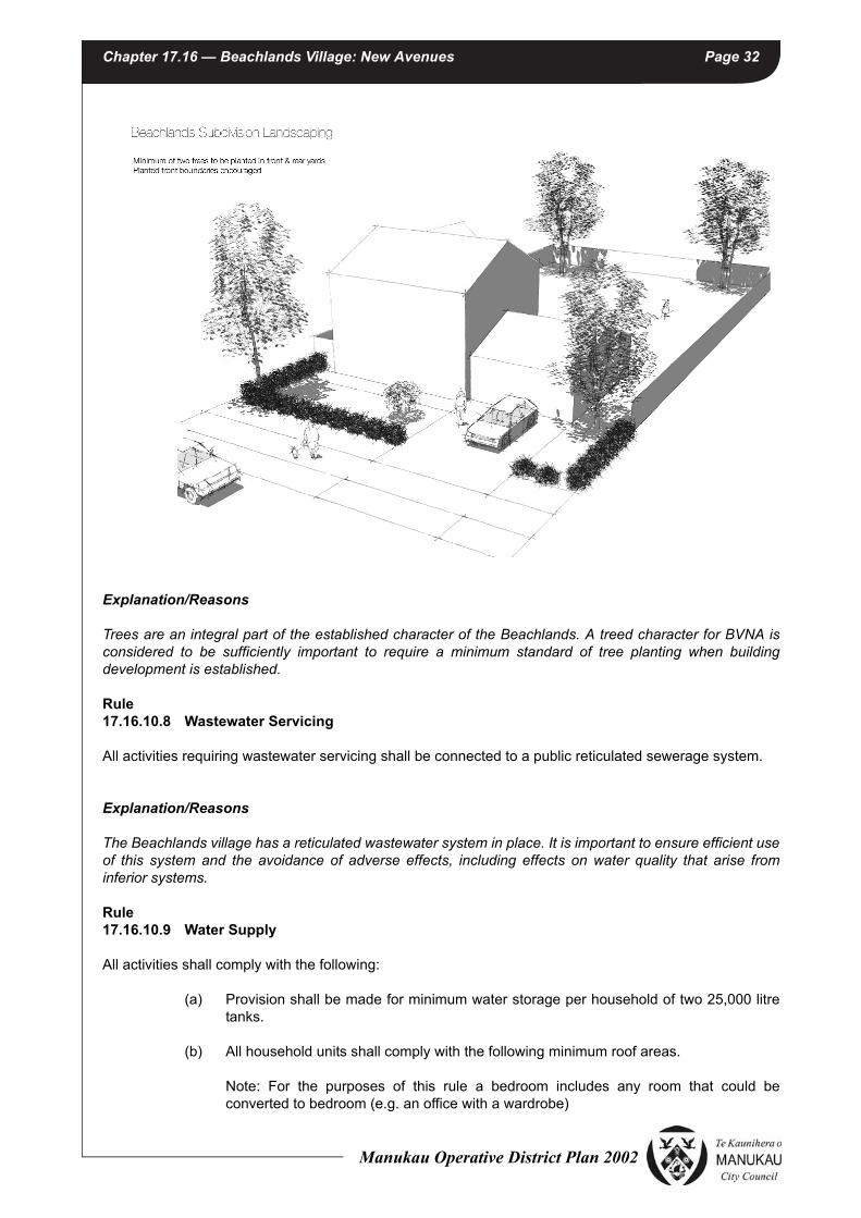
Chapter 17.16 — Beachlands Village: New Avenues Page 32
Explanation/Reasons
Trees are an integral part of the established character of the Beachlands. A treed character for BVNA is considered to be sufficiently important to require a minimum standard of tree planting when building development is established.
Rule17.16.10.8 Wastewater Servicing
All activities requiring wastewater servicing shall be connected to a public reticulated sewerage system.
Explanation/Reasons
The Beachlands village has a reticulated wastewater system in place. It is important to ensure efficient use of this system and the avoidance of adverse effects, including effects on water quality that arise from inferior systems.
Rule17.16.10.9 Water Supply
All activities shall comply with the following:
(a) Provision shall be made for minimum water storage per household of two 25,000 litre tanks.
(b) All household units shall comply with the following minimum roof areas.
Note: For the purposes of this rule a bedroom includes any room that could be converted to bedroom (e.g. an office with a wardrobe)
Manukau Operative District Plan 2002

Chapter 17.16 — Beachlands Village: New Avenues Page 33
(c) The following water conservation devices shall be used in all new buildings:
(i) dual flush 6/3 litre toilets;
(ii) showerhead flow restrictors; and
(iii) aerator taps.
(d) Provision shall be made for sufficient water supply and access to water supplies for fire fighting purposes consistent with NZ Fire Service Fire Fighting Water Supplies Code of Practice SNZ PAS 4509:2008 (or subsequent amendments).
(e) Private water storage tanks shall not be visible from the street frontage.
Exception to the Rule: 17.16.10.9 (a) and (b) shall not apply to activities where a connection to a reticulated bore water supply is provided to the site
Note: For the purposes of this Rule a Reticulated Water Supply includes all infrastructure constructed as part of a residential development and approved by Council for vesting as a public system that provides potable water from a central source to the boundaries of all sites within the development, and shall include provision made for sufficient capacity and connections to existing or future residential development.
Explanation/Reasons
BVNA does not have a reticulated water supply. The supply, use, and conservation of water is therefore a critical component for the future sustainability of the village. It is acknowledged that 4 bedrooms plus housing may need to be serviced using bore water supply or regular water delivery may be required.
Rule17.16.10.10 Erosion / Sediment Control
(a) All provisions in Chapter 9 – Land Modification, Development and Subdivision shall apply.
(b) All earthworks shall be undertaken in general accordance with the Erosion / Sediment Control Measures in Appendix A.
(c) All methods of sediment control shall be provided in accordance with the Beachlands Integrated Catchment Management Plan (ICMP) or any relevant approved Network Discharge Consent.
Explanation/Reasons
This rule recognises that land disturbing activities in the BVNA have the potential of generating and discharging levels of sediment which may have an adverse effect on the quality of the sensitive receiving environment, including the coastal marine area.
Number of Bedrooms
Minimum Roof Area (m2) Connected to the Water Storage Tank
1 100
2 160
3 and above 230
Manukau Operative District Plan 2002

Chapter 17.16 — Beachlands Village: New Avenues Page 34
Rule 17.16.10.11 Noise
Rule 13.11.1.1 and Rules in Section 5.18.3 Chapter 5 General Procedures and Rules shall apply.
Rule 17.16.10.12 Odour
Rule 13.11.1.8 shall apply.
Rule 17.16.10.13 Artificial Lighting
Rule 5.18.2 Chapter 5 General Procedures and Rules shall apply provided that references in that Rule to residential sites shall also apply to sites in the Whitford Rural Zone.
Rule 17.16.10.14 Vibration
Rule 5.18.4 Chapter 5 General Procedures and Rules shall apply.
Rule 17.16.10.15 Traffic Generation
Rule 13.11.1.6 shall apply.
17.16.11 MATTERS FOR DISCRETION: RESTRICTED DISCRETIONARY ACTIVITIES
Rule 17.16.11.1 Activities listed as Permitted in the Activity Table Rule 17.16.9.2 that do not comply
with the development and performance standards in Rule 17.16.10.1 (maximum height)
The Council restricts the exercise of its discretion to the following matters for an activity that does not comply with the development and performance standards in Rules 17.16.10.1 (maximum heights) and may impose conditions in respect of each:
(a) Sunlight and daylight provision.
(b) Scale
(c) Design and external appearance
(d) Heritage Elements
(e) Disruption to views
(f) Matters in Section 5.19, Chapter 5
Manukau Operative District Plan 2002

Chapter 17.16 — Beachlands Village: New Avenues Page 35
Rule 17.16.11.1.1
When assessing an application for the above activity in Rule 17.16.11.1, the Council will have regard to the following assessment criteria and any relevant matters set out in Section 104 of the Act:
(a) Sunlight and daylight
(i) Whether the increase in height will have an adverse effect on access to sunlight and daylight to adjoining sites.
(b) Scale
(i) Whether any additional height contributes to the bulk of a building and causes dominance or intrusion on adjoining properties.
(ii) Whether the proposed height of building and other structures will be compatible with the height and visual character of the streetscape, surrounding area and the character of the Beachlands village.
(c) Design and external appearance
(i) Whether the proposed height contributes to good architectural design.
(ii) Whether the design and external appearance of the building makes a positive contribution to the streetscape.
(d) Heritage Elements
(i) Whether the proposed height of buildings and other structures will be compatible with any special character and any relevant heritage values of the area.
(e) Disruption to Views
(i) Whether the proposed height of the building or other structures will disrupt the views to the sea and the coastal edge from the Whitford-Maraetai Road.
(f) Matters in Section 5.19, Chapter 5
(i) See assessment criteria 5.19.2 Chapter 5 General Procedures and Rules.
Rule 17.16.11.2 Activities listed as Permitted in the Activity Table Rule 17.16.9.2 that do not comply
with the development and performance standards in Rule 17.16.10.2(b) (side yards)
The Council restricts the exercise of its discretion to the following matters for an activity that does not comply with the development and performance standards in Rules 17.16.10.2(b) (side yards) and may impose conditions in respect of each:
(a) Amenity values, including streetscape and landscape elements, and on-site amenity of adjoining properties.
Rule 17.16.11.2.1
When assessing an application for the above activity in Rule 17.16.11.2, the Council will have regard to the following assessment criteria and any relevant matters set out in Section 104 of the Act:
Manukau Operative District Plan 2002

Chapter 17.16 — Beachlands Village: New Avenues Page 36
(a) whether the infringement is minor and whether it is offset by other factors that mitigate any adverse effects, e.g. additional planting;
(b) whether a reduction in yards will cause adverse effects on the privacy of adjoining neighbours;
(c) whether the reduction in yards had adverse effects on the character of the streetscape;
(d) whether the reduction in yards will adversely affect any identified character qualities of the Beachlands village.
(e) whether a reduction in yards will cause adverse effects on onsite amenity, in particular whether it will adversely affect the function and safety of vehicle access.
Rule 17.16.11.3 Activities listed as Permitted in the Activity Table Rule 17.16.9.2 that do not comply
with the development and performance standards in Rule 17.16.10.3 (Garage Setback)
The Council restricts the exercise of its discretion to the following matters for an activity that does not comply with the development and performance standards in Rule 17.16.10.3 (Garage Setback) and may impose conditions in respect of:
(a) Streetscape elements;
(b) Safety;
(c) Amenity Values
Rule17.16.11.3.1
When assessing an application for resource consent for the above activity Rule 17.16.11.3, the Council will have regard to the to the following assessment criteria and any relevant matters set out in Section 104 of the Act:
(a) Whether the proposal creates an adverse effect on the character of the streetscape.
(b) Whether the proposal has adverse effects on the level of safety on the street or public place (including public open space) in term of public surveillance.
(c) Whether the proposal has an impact on amenity values of the area, including streetscape and landscape elements, on site amenity of adjoining properties.
Rule 17.16.11.4 Activities listed as Permitted in the Activity Table Rule 17.16.9.2 that do not comply
with the development and performance standards in Rule 17.16.10.6 (Roof Types)
The Council restricts the exercise of its discretion to the following matters for an activity that does not comply with the development and performance standards in Rule 17.16.10.76 (Roof Types) and may impose conditions in respect of:
(a) The nature of any roofing material.
Manukau Operative District Plan 2002

Chapter 17.16 — Beachlands Village: New Avenues Page 37
Rule 17.16.11.4.1
When assessing an application for resource consent for the above activity Rule 17.16.11.4, the Council will have regard to the to the following assessment criteria and any relevant matters set out in Section 104 of the Act:
(a) Whether treatment of stormwater is provided on site to remove adverse effects on receiving waters.
Rule17.16.11.5 Activities listed as Permitted in the Activity Table Rule 17.16.9.2 that do not comply
with the development and performance standards in Rule 17.16.10.9 (Water Supply)
When assessing an application for resource consent for the above activity Rule 17.16.11.5, the Council will have regard to the to the following assessment criteria and any relevant matters set out in Section 104 of the Act:
(a) Whether there is adequate water supply to service the proposed activity. As a general guide it should not be necessary to rely on tankered water from a water source external to the Beachlands area.
(b) Whether, if required, water supply is able to be supplemented by using an alternative source of water supply, such as bore water supply.
(c) Whether and the extent to which the water supply is consistent with the current NZ Fire Service Code of Practice or approval by the regional New Zealand Fire Service has been provided.
Rule 17.16.11.5.1
When assessing an application for resource consent for the above activity Rule 17.16.11.5, the Council will have regard to the to the following assessment criteria and any relevant matters set out in Section 104 of the Act:
(a) Whether adequate amount of water supply to service the proposed activity is able to be provided using alternative sources of water supply, such as bore water supply.
(b) whether advice or approval from the regional New Zealand Fire Service has been provided in using an alternative source of water supply.
Rule 17.16.11.6 Accessory Buildings exceeding 40m2 gross floor area
The Council restricts the exercise of its discretion to the following matters for accessory buildings exceeding 40m2 gross floor area and may impose conditions in respect of:
(a) Extent of compliance with development and performance standards.
(b) Amenity values, including effects on adjoining properties and streetscape values.
Rule 17.16.11.6.1
When assessing an application for resource consent for the above activity in Rule 17.16.11.6, the Council will have regard to the following assessment criteria and any relevant matters set out in Section 104 of the Act:
Manukau Operative District Plan 2002

Chapter 17.16 — Beachlands Village: New Avenues Page 38
(a) The building should generally comply with the development and performance standards in Rule 17.16.10 so that the effects of the accessory buildings are similar to those of permitted activities;
(b) Whether the bulk or size of the accessory building will detract from streetscape values;
(c) Whether the accessory building will cause dominance or intrusion on adjoining properties;
(d) Whether the design and external appearance of the accessory building is in keeping with the style of buildings on-site;
(e) Whether the increase in size is minor and will not cause adverse effects on adjoining neighbours.
Rule 17.16.11.7 Childcare Services and Facilities for more than 10 children; Homes for the Aged
accommodating more than 15 persons; and Residential Centres and Hostels
The Council restricts the exercise of its discretion to the following matters for Childcare Services and Facilities for more than 10 children; Homes for the Aged accommodating more than 15 persons; and Residential Centres, and may impose conditions in respect of:
(a) Extent of compliance with development and performance standards.
(b) Effects on the natural environment.
(c) Servicing
(d) Scale and intensity of use.
(e) Effects on the neighbourhood
(f) Effects on the neighbouring sites.
(g) Effects on the transportation network
(h) Cumulative effects
(i) Signs
Rule 17.16.11.7.1
When assessing an application for resource consent for the above activities in Rule 17.16.11.7, the Council will have regard to the to the assessment criteria listed in Rule 17.16.12.1 and any relevant matters set out in Section 104 of the Act:
17.16.12 ASSESSMENT CRITERIA FOR DISCRETIONARY ACTIVITIES
Rule 17.16.12.1 General Assessment Criteria – All Discretionary Activities
In deciding whether to grant or refuse consent for a discretionary activity application and in imposing conditions if consent is granted the Council shall have regard to Rule 13.14 and to the following general matters and any relevant matters contained in section 104 of the Resource Management Act 1991.
Manukau Operative District Plan 2002

Chapter 17.16 — Beachlands Village: New Avenues Page 39
(a) Extent of compliance with development and performance standards
(i) The activity should generally comply with the development and performance standards in Rule 17.16.10 so that the effects of the buildings are similar to those of permitted buildings.
(b) Effects on the Natural Environment
(i) Whether any discharges to land, water or air (including dust, smoke, fumes or odour) or the presence of hazardous substances will result in any significant reduction in the quality of the physical environment or detract from the existing or planned amenity values or the rural and coastal village character of the Beachlands village.
(c) Servicing
(i) The public utility and servicing requirements of the proposed activity, including the provision for waste and stormwater disposal services existing or planned should not place undue pressure on the capacity of the utilities and services. Whether the development incorporates works that mitigate any such pressures.
(ii) Adequate provision for potable water supply should be made to meet the servicing needs of the proposed activity.
(iii) Private water supply tanks should be undergrounded, and/or consideration should be given to the design, location, and landscaping to ensure that it is not visually prominent from the street frontage.
(d) Scale and Intensity of Use
(i) The site of the activity should be of a sufficient size and configuration to allow the adequate mitigation of the effects of the activity on the surrounding neighbourhood.
(ii) The intensity and scale of the activity should be controlled to protect the amenity of that neighbourhood and the rural and coastal village character of the BVNA.
(e) Effects on the neighbourhood
(i) The scale, design, layout, external appearance and landscaping of the buildings and sites should enhance the rural and coastal village character and amenity values expected in BNVA.
(ii) In the case of non-residential activities, the character of the activity and its effects should be compatible with the rural and coastal village character and amenity values expected in BVNA.
(iii) The non – residential activities should not break up residential communities and leave residents without close neighbours.
(f) Effects on the neighbouring sites
(i) The activity should be designed and carried out in a way that avoids or mitigates the adverse effects of noise, vibration, electrical interference, visual intrusion and light overspill on to adjacent sites. Particular attentions should be given to maintaining a quiet night environment, and minimising risk to people’s health and safety.
Manukau Operative District Plan 2002

Chapter 17.16 — Beachlands Village: New Avenues Page 40
(ii) The activity should be designed and carried out in a way that preserves the privacy of the adjacent residential sites.
(iii) The site should have a frontage and access to a formed public road of sufficient width so that the activity can be accessed from the street without causing adverse effects on the neighbouring sites.
(g) Effects on the transportation network
(i) The integrity, intent and functionality of the roading layout should be maintained in strict accordance with the roading layout shown in the BVNA Structure Plan.
(ii) The development should not have adverse effects on the character of the proposed avenues and other roads in the BVNA Structure Plan as an open space element.
(iii) The vehicular traffic generated by the activity, including cars parked on the roads, should be accommodated without a loss of safety or efficiency of the road network, and without loss of residential amenity.
(h) Cumulative Effects
(i) In addition to the above, the Council will consider any cumulative effects as defined in the Act. Consideration should be given to the presence of activities already located in the area and on the site, and their combined effects on the surrounding neighbourhood.
(i) Signs
(i) The scale, design and location of signs should be sensitive to the residential and rural and coastal village character of the Beachlands village.
(j) Design Guidelines
(i) Whether the proposed activity complies with the principles contained in theBVNA Design Guidelines.
(k) Lighting
(i) Whether the design of light fittings and light poles (including in terms of placement, aiming, height, and screening) minimises light spill, glare, loss of night sky viewing, and adverse effects on visual amenity from the surrounding rural environment, having regard to current relevant standards and codes of practice.
17.16.13 SUBDIVISION
Rule17.16.13.1 General
Subdivision in any part of the BVNA Structure Plan as shown on Figure 17.16.1 shall comply with the following:
(a) Any application for subdivision that complies with Rule 17.16.13.2 is a Restricted Discretionary Activity and shall be assessed against the Matters for Discretion set out in Chapter 9 and Rule 17.16.13.3.
Manukau Operative District Plan 2002

Chapter 17.16 — Beachlands Village: New Avenues Page 41
(b) Any application for subdivision that does not comply with one or more of the development and performance standards, set out in Rule 17.16.13.2, except Rules 17.16.13.2.2 (Roading Network) and 17.16.13.2.3(a) (Site Area), 17.16.13.2.4 (Site Frontage) and 17.16.2.5(c) (Rear Sites) shall be a Discretionary Activity.
(c) Any application for subdivision that does not comply with Rule 17.16.13.2.3(a) (Site Area), 17.16.13.2.4 (Site Frontage) and 17.16.2.5(c) (Rear Sites) shall be a Non–Complying Activity.
(d) Where a specified centre line for a proposed road is shown in Figure 17.16.2 (Beachlands Village New Avenues Roading Plan), any application for subdivision that does not comply with Rule 17.16.13.2.2 (Roading Network) shall be a Non-Complying Activity.
(e) Where a specified centre line for a proposed road is not shown in Figure 17.16.2 (Beachlands Village New Avenues Roading Plan), any application for subdivision that does not comply with Rule 17.16.13.2.2 (Roading Network) shall be a Restricted Discretionary Activity.
(f) All Discretionary Activities shall have regard to the assessment criteria contained in Chapter 9 and Rule17.16.13.4, and any other relevant matter under section 104 of the Resource Management Act 1991.
(g) Where an application for resource consent is subject to more than one activity status the most restrictive activity status is to apply to the application.
(h) An application for resource consent for a Restricted Discretionary Activity that complies with development and performance standards, will not require public notification under Section 95A of the Resource Management Act 1991, nor will there be any affected persons under Section 95B of the Resource Management Act 1991 unless special circumstances exist, or the applicant requests that the application be notified under Section 95A (2) (b) of the Act.
(i) Any decision on whether a Discretionary Activity application will require public notification, service of notice of the application or the consent of adversely affected parties is subject to sections 93 and 94 of the Resource Management Act 1991.
Rule17.16.13.2 Subdivision Development and Performance Standards for Restricted Discretionary
Activities
Rule17.16.13.2.1General
Rules in Chapter 9 - Land Modification, Development and Subdivision shall apply, except as specified in the following rules.
Rule17.16.13.2.2Roading Network
(a) All roads shall be constructed in accordance with the grid roading layout shown in the BVNA Structure Plan Figure 17.16.1 and the centre line specifications as stated in Figure 17.16.2.
(b) All Collector Roads, Local Roads and Lanes shown in Figure 17.16.2 shall be built in general accordance with the cross sections below:
Manukau Operative District Plan 2002

Chapter 17.16 — Beachlands Village: New Avenues Page 42
PROPOSED TYPICAL LOCAL ROAD
PROPOSED PRIVATE LANES
PROPOSED TYPICAL PUBLIC LANE
3% CROSSFALL3% CROSSFALLBATTER
1:5 MAX2% 3-5% BATTER
1:5 MAX2%3-5%
7.20m SEALED WIDTH
6.10m
2.80m1.50m1.80m
RD
BD
Y
FOOTPATH
7.80m CARRIAGEWAY WIDTH
m LEGAL ROAD WIDTH
6.10m
2.80m 1.50m 1.80m 0.60m
RD
BD
Y
FOOTPATH
0.60m
SERVICES BERM SERVICES BERMPLANTING BERM PLANTING BERM
3-5% CROSSFALLBATTER
1:5 MAX
3-5%
0.70m
AC
CE
SS
LA
NE
BD
Y
4.50m CARRIAGEWAY WIDTH
6.50m LEGAL ROAD WIDTH
1.30m0.60m
SERVICES
BERMA
CC
ES
S L
AN
E B
DY
BATTER
1:5 MAX
0.60m
3% CROSSFALL3% CROSSFALLBATTER
1:5 MAX2% 3-5%
BATTER
1:5 MAX2%3-5%
4.80m SEALED WIDTH
3.30m
1.50m
RD
BD
Y
FOOTPATH
5.40m CARRIAGEWAY WIDTH
12.00m LEGAL ROAD WIDTH
3.30m
1.50m
0.60mRD
BD
Y
FOOTPATH
1.40m 1.40m0.40m 0.40m
0.60m
Manukau Operative District Plan 2002

Chapter 17.16 — Beachlands Village: New Avenues Page 43
PROPOSED TYPICAL COLLECTOR ROAD
(c) The corner radius on road intersections shall be 7m, except on collector road/ collector road intersections where the corner radius shall be 10m.
(d) Where the subdivision is of an existing site that adjoins Beachlands Road, the first stage of any subdivision shall include a public road connection to Beachlands Road. Where the subdivision is of an existing site that adjoins Karaka Road, the first stage of subdivision shall include a public road connection to Karaka Road. Where the subdivision is of an existing site that adjoins Jack Lachlan Drive, the first stage of subdivision shall include a public road connection to Jack Lachlan Drive.
(e) Where a collector road is shown on Figure 17.16.2 the entire length of the collector road through the site being the subject of the subdivision shall be established as part of the first stage of subdivision, except for
(i) Lot 2 DP 325925, where the collector road shall be established prior to the issue of a section 224(c) certificate under the Resource Management Act 1991 for more than 80 residential sites within the land contained in that Lot.
(f) There shall be no direct vehicle access off the Whitford-Maraetai Road.
(g) No lots shall be served by a jointly owned access or similar shared access except for:
• the Lanes shown on Figure 17.16.2
• entrance strips and private ways required to access rear sites identified in the BVNA Structure Plan. These entrance strips and private ways shall comply with Rule 9.9.2.10.
(h) Road levels shall enable integration with the existing or potential road layout on adjoining sites.
(i) Lot 1079 DP 21695 is zoned Beachlands Residential Zone and is able to be utilised for access purposes for Lot 1119 DP 21695 subject to Controlled Activity consent, subject to the provisions set out in Rule 9.8.1.2.
(j) Where a site adjoins Jack Lachlan Drive, no direct vehicle access on to Jack Lachlan Drive shall be provided for in the area specified as “no direct site access permitted” on the BVNA Structure Plan.
(k) Where a site adjoins Jack Lachlan Drive, and direct vehicle access is permitted, where possible shared access driveways are to be used.
3% CROSSFALL
10.20m SEALED WIDTH
3% CROSSFALL
4.60m
1.30m1.50m1.80m
BATTER
1:5 MAX
RD
BD
Y
FOOTPATH
2%
10.80m CARRIAGEWAY WIDTH
20.00m LEGAL ROAD WIDTH
3-5%
4.60m
1.30m 1.50m 1.80m 0.60m
RD
BD
Y
FOOTPATH
2%3-5%
0.60m
SERVICES BERM SERVICES BERM
BATTER
1:5 MAX
PLANTING
BERM
PLANTING
BERM
Manukau Operative District Plan 2002

Chapter 17.16 — Beachlands Village: New Avenues Page 44
(l) Subject to the following exceptions, Jack Lachlan Drive is to be retained in its current rural standard formation to maintain its appearance as a rural rather than urban road. Where there is to be any alteration to the current rural standard formation it is to be limited to:
(i) Kerb and channelling of the road edge for those areas of Jack Lachlan Drive where there is no alternative to provide for stormwater runoff from adjacent residential development; and/or
(ii) Kerb and channelling of the road edge which is necessary to provide for vehicle access from adjacent residential development or new road intersections with Jack Lachlan Drive; and/or
(iii) A footpath of appropriate rural character (gravelled surface or similar).
Explanation/Reasons
A connected street pattern is encouraged to provide for permeability, legibility and a residential rural and coastal village character which reflects the existing pattern of development in the Beachlands village. The BVNA structure plan establishes a pattern of development where buildings face onto and are serviced from the main street frontage or other important public spaces. This arrangement creates an easily understood, maintained and safe environment. Access is limited on to Jack Lachlan Drive and the road is to retain its current rural standard formation to assist in creating a defined, defensible edge to the urban area.
Rule17.16.13.2.3Site Area
The minimum net site area shall be 800m2, provided that:-
(a) the minimum site area may be reduced to 750m2 in Precinct A and 700m2 in Precinct B, as shown on the BVNA Structure Plan Figure 17.16.1;
(b) the minimum site area may be reduced as a Discretionary Activity where an application for subdivision relates to a development established for Homes for the Aged.
Rule17.16.13.2.4Site Frontage
The minimum site frontage shall be:
• Front sites 20m
• Rear sites 3m
Rule17.16.13.2.5Site Layout
(a) The layout of the sites within the street blocks shown on the BVNA Structure Plan Figure 17.16.1 shall be of a configuration which is in accordance with the illustration below, except for the street blocks containing rear sites or sites which adjoin but do not have vehicle access to Jack Lachlan Drive identified in the BVNA Structure Plan in which case the layout of the sites shall make allowance for those sites but otherwise be in general accordance with the illustration below:
Manukau Operative District Plan 2002

Chapter 17.16 — Beachlands Village: New Avenues Page 45
(b) The layout of the sites within the street blocks shall be such that it enables all future buildings to be designed to face and front onto the active street frontage, except:
(i) where sites directly adjoin Stormwater Management Areas in which case the buildings shall be designed to face and front onto the reserves.
(ii) rear sites.
(iii) where sites adjoin but do not gain access from Jack Lachlan Drive.
(c) There shall be no rear sites, except to the maximum number specified within the street blocks identified in the BVNA Structure Plan Figure 17.16.1.
Explanation/Reasons
A specified site area, site frontage and site layout standards are necessary to ensure that a site has sufficient area to accommodate a house of a reasonable size within the Development Standards of the Beachlands Residential Zone. These Development Standards have been designed to maintain the amenity values of the rural and coastal village neighbourhood including retaining the qualities of space around housing, a sense of openness, a single house on a single site and protection of vegetation. The only exception is that provision is made for subdivision associated with “Homes for the Aged” (e.g. retirement villages, provided that such developments must have been established prior to subdivision.
Rule17.16.13.2.6Reserves
All land shown as Public Open Space on the BVNA Structure Plan shall be vested in Council as part of the reserves contribution in the locations specified in the BVNA Structure Plan.
Manukau Operative District Plan 2002

Chapter 17.16 — Beachlands Village: New Avenues Page 46
Note: Council will compensate the subdivider or developer for any land required as Public Open Space in excess of the 6 percent required for reserve contribution (refer Rule 15.15.2.2.4).
Rule17.16.13.2.7Stormwater Management Areas
In addition to Rules 9.8.3, 9.9.2.7, 9.11.4, 9.12.1 and 9.12.10 - Stormwater Management Areas, the following rules apply to the Stormwater Management Areas shown in the BVNA Structure Plan:
(a) The underlying zoning of the land in the Stormwater Management Area shall be Beachlands Residential Zone.
Note: Where the stormwater system works and associated land required for stormwater management on a particular landholding is in excess of that necessitated by or required to serve a subdivision or development of that landholding, Council will compensate or otherwise provide credit to the subdivider or developer for the additional stormwater system works and additional land (refer Rule 9.14.5.1(e)).
(b) All building platforms within the subdivision shall be wholly outside the Stormwater Management Area.
(c) Access to all lots within the subdivision shall be located wholly outside the Stormwater Management Area.
(d) All riparian margin areas within the Stormwater Management Area shall be planted in accordance with the following provisions:
(i) A revegetation plan / programme shall be required, covering the following matters:
• Pre-planting Site Assessment;
• Planting Plan Assessment;
• Annual Monitoring Programme.
The revegetation plan / programme shall be prepared having regard to Appendix A – Guidelines for Native Revegetation Planting contained in Chapter 12A – Whitford Rural Area.
(ii) Planting shall be at a minimum density of 1.4metre centres (5,100 stems per hectare) provided that a greater density may be required in some situations, for instance where there is significant weed infestation or planting is in the proximity of streams or wetlands.
(iii) The subdivision developer shall be responsible for the implementation of the revegetation plan / programme for a period of 2 years from the time of planting, which shall be secured by suitable legal instrument.
Rule17.16.13.2.8Recreational Walkways
Recreational Walkways shall be located generally in accordance with the route shown in the BVNA Structure Plan.
Rule17.16.13.2.9Street Trees
(a) Street trees shall be planted in accordance with Rule 9.9.2.11(b);
Manukau Operative District Plan 2002

Chapter 17.16 — Beachlands Village: New Avenues Page 47
(b) Street tree planting on the north side of Jack Lachlan Drive shall create a lineal effect such that the trees, rather than the built development behind, become the dominant visual feature as viewed from the road;
(c) All species selected for street tree planting are to be approved by the Council.
Rule17.16.13.2.10Wastewater Servicing
All allotments capable of accommodating future buildings shall be provided with a connection to the public reticulated sewerage system and shall be designed and configured to service the upstream catchment in its ultimate land use.
Rule17.16.13.2.11Landscape Buffer Area
A Landscape Buffer Area shall be developed along Whitford – Maraetai Road, as identified in the BVNA Structure Plan Figure 17.16.1, and shall meet the following standards:
(a) the Landscape Buffer Area shall be consistent with the widths indicated in the BVNA Structure Plan (minimum width at any point – 15m);
(b) That part of the Landscape Buffer Area within any existing site shall be established as a condition of any subdivision of that site.
(c) the Landscape Buffer Area shall be planted out in accordance with the Landscape Buffer Area Planting Plan and Planting Schedule contained in Appendix B, prior to the issuing by the Council of the section 224(c) certificate under the Resource Management Act 1991 in relation to the subdivision referred to in (b) above.
(d) A Planting Plan shall be provided by a suitably qualified professional containing the following information:
(i) site preparation for planting, weed and pest control;
(ii) existing trees to be retained, species to be planted, size of plants, where they are to be planted and density of planting;
(iii) maintenance of planting, including fertiliser, replacing dead plants, animal and plant pest control and mulching.
(e) The developer shall be responsible for the maintenance of the Landscape Buffer Area, including weed control, mulching and watering and any necessary plant replacement, for a period of 3 years from the time of planting.
Note: Council may impose a bond to ensure compliance with (e) above.
(f) Subject to the above requirements, the Landscape Buffer Area shall be vested in the Council free of charge at a time to be determined in the subdivision consent, being no more than 2 years after issue by the Council of the section 224(c) certificate under the Resource Management Act 1991.
Rule 17.16.13.2.12Planted Hedge – Jack Lachlan Drive
Where a site adjoins that part of Jack Lachlan Drive specified as “no direct site access permitted” on the BVNA Structure Plan a planted hedge is to be provided for the full length of the Jack Lachlan Drive boundary of the site. The hedge species selected shall be capable of reaching and be maintained at a
Manukau Operative District Plan 2002

Chapter 17.16 — Beachlands Village: New Avenues Page 48
height of no less than 2.0m. The planted hedge shall be subject to appropriate legal protection, arranged at the time of subdivision.
Rule17.16.13.3 Matters for Control: Restricted Discretionary Activities
For all land modification, development and subdivision that is a Restricted Discretionary Activity under this Rule, regard shall be given to the following matters in addition to the matters set out in Chapter 9 Land Modification, Development and Subdivision. Council restricts the exercise of its discretion to all these matters and may impose conditions in respect of:
(a) Extent of compliance with development and performance standards
(b) Earthworks and sediment control
(c) Recreational walkways
(d) Stormwater Management Area
(e) Roading Network
(f) Public Open Space
(g) Stormwater Management
(h) Lighting
(i) Rear sites
Rule17.16.13.4 Matters for Assessment – Restricted Discretionary Activities
For all land modification, development and subdivision that is a Restricted Discretionary Activity under this Rule, regard shall be given to:
(a) The matters of assessment set out in Chapter 9 Land Modification, Development and Subdivision.
(b) Roading Network
(i) The roading pattern should produce a rectangular grid layout consistent with that shown in Figure 17.16.2.
(ii) All roads should be designed to enable integration with existing or potential road layouts on adjoining sites.
(iii) The roading pattern should be designed to enhance public access to reserves and take advantage of coastal and rural vistas.
(c) Stormwater Management Area
(i) In the preparation of the revegetation plan / programme for the Stormwater Management Area, consideration should be given to the appropriateness of the retention of the existing trees either on a permanent basis or until the new planting has been established.
(d) Design Guidelines
Manukau Operative District Plan 2002

Chapter 17.16 — Beachlands Village: New Avenues Page 49
(i) Whether the proposed activity complies with the principles contained in the BVNA Design Guidelines.
(e) Lighting
(i) Whether the design of light fittings and light poles (including in terms of placement, aiming, height, and screening) minimises light spill, glare, loss of night sky viewing, and adverse effects on visual amenity from the surrounding rural environment, having regard to current relevant standards and codes of practice.
(f) Rear Sites
(i) In the case of any sites that are created initially as rear sites but will ultimately be a front site with frontage to a Proposed Local Road shown in the BVNA Structure Plan, whether the site layout is designed to enable all future buildings to face and front the Proposed Local Road.
(g) Jack Lachlan Drive Edge
(i) Whether sites in excess of 800m2 adjoin the majority of the length of Jack Lachlan Drive
Rule17.16.13.5 Financial Contributions for Public Utility Services
Refer Chapter 9 Land Modification, Development and Subdivision.
Rule17.16.14.6 Public Open Space and Reserve Contributions
Refer Chapter 15 Public Open Space
FIGURES
• Figure 17.16.1: Beachlands Village: New Avenues Structure Plan.
• Figure 17.16.2: Beachlands Village: New Avenues Roading Network Plan.
• Appendix A: Erosion and Sediment Control Measures.
• Appendix B: Landscape Buffer Area Planting Plan and Planting Schedule.
Manukau Operative District Plan 2002

Chapter 17.16 — Beachlands Village: New Avenues Page 50
FIGURE 17.16.1: BEACHLANDS VILLAGE: NEW AVENUES STRUCTURE PLAN
SEVE
NTHVIEW
AVEN
UE
EIGH
THVIEW
AVEN
UE
NINTH
VIEW
AVEN
UE
BEAC
HLAN
DSRD
JACK
LACH
LANDR
V
KARA
KARD
WHITFORD MARAETAI RD
BELLRD
LIBERTYCRES
SHELLYBAY
RD
IN
TREPIDCRES
CONSTELLA
TIONAVE
TUIBRAE
FERN
PL
PINE
HARB
OUR
P
DE
WAKELINRD
THEWAY
THISTLECL
SUNKISTBA
YRD
COLUMBIACR
ES
LOMEER
WAY
MARINERLN
P ONY
PARK
PL
COURA
GEOUSPL
WATERFO
RDWAY
PINE
HARB
OURPD
E
291
3
2
2
2
1
FIG
UR
E 1
7.1
6.1
- B
EA
CH
LA
ND
S V
ILL
AG
E:
NE
W A
VE
NU
ES
ST
RU
CT
UR
E P
LA
NM
axim
um
Nu
mb
ers
of
Re
ar
Site
s W
ithin
Ea
ch
Blo
ck
Be
ach
land
s V
illa
ge
Ne
w A
ve
nue
s S
tructu
re P
lan
Are
a
Pro
tecte
d T
ree
s
Indic
ative
Wa
lkw
ay
La
nd
scap
e B
uffe
r A
rea
(m
inim
um
15m
)
This
are
a is r
ezon
ed
un
de
r P
PC
30
A (
for
info
rma
tion p
urp
ose
s o
nly
)
Pro
pose
d R
oa
ds
De
sig
natio
n 2
91
Pu
blic
Op
en
Sp
ace
Re
sid
entia
l P
recin
ct A
(m
inim
um
75
0
m2
site
s)
Re
sid
entia
l P
recin
ct
B (
min
imu
m 7
00
m2 s
ites)
Be
ach
land
s R
esid
en
tial Z
on
e
Flo
odp
lain
Str
om
wa
ter
Mana
ge
ment A
rea
Ind
ica
tive
Sto
rmw
ate
r P
on
d
No
Dir
ect
Site
Acce
ss P
erm
itte
d0
10
020
030
040
050
050
Me
ters
1:6
,000
@ A
3
Manukau Operative District Plan 2002

Chapter 17.16 — Beachlands Village: New Avenues Page 51
FIGURE 17.16.2: BEACHLANDS VILLAGE: NEW AVENUES ROADING NETWORK PLAN
SEVE
NTH
VIEW
AVEN
UE
EIGHT
HVIEW
AVEN
UE
NINTH
VIEW
AVEN
UE
KA
RA
KA
RD
JA
CK
LA
CH
LA
ND
RV
BE
AC
HLA
ND
SR
D
WHITFORDMARAETAIRD
BELLRD
LIBERTYCRES
INT
RE
PID
CR
ES
SHELLYBAY RD
TU
IBR
AE
FE
RN
PL
TH
E W
AY
PINEHARBOURPDE
THISTLECL
CO
LU
MB
IAC
RE
S
291
291
E: 421
845.7
8
E: 42187
4.6
4
E: 4
21503.4
9E: 4
21557.2
1
E: 421
586.1
7
E: 421
619.1
3
E: 4
21479.1
4E
: 42127
5.9
6
E: 421192
.61
E: 420
883.0
7
E:
420966
.54
E: 42046
5.1
5
E: 42
0492.1
0
E:
420521
.59
15°48'
15°48'
15°48'
15°48'
15°48'
15°48'
15°48'
15°48'
15°48'
15°48'
15°55'
15°55'
15°55'
15°55'
15°55'
15°55'
15°56'
15°56'
15°56'
113°
21'
105 °
52'
105°
52'10
5°52
'105°
56'10
5°43
'
105°
52'10
5°52
'105°
52'
105°
55'
105 °
55'
105 °
55'
105°
55'
105 °
52'
105°
52'10
5°52
'
N: 79
8710.0
7
N: 7988
12.0
8
N:
79860
2.2
4N: 798
792.0
8
N: 79
8894.4
5
N: 7
9901
0.9
6
N: 7989
24.9
8N
: 7989
82.9
4
N: 7
98690
.59
N: 79
8778.5
6
N: 79
9071.2
1
N: 799
000.3
6
N: 7
99094
.79
N: 7991
98.1
3
15°48'
105°
52'10
5°52
'105°
52'
15°48'15°48'
15°48'
15°48'
15°48'
15°48'
15°48'
15°48'15°48'
15°48'15°48'
15°55'15°55'
15°55'
15°55'
15°55'
15°55'
15°56'15°56'
15°56'
113°
21'
105°
52'
105°
52'105°
52'105°
56'10
5°43
'
105°
52'105°
52'105°
52'
105°
55'
105°
55'
105°
55'
105°
55'
105°
52'
105°
52'105°
52'
105°
52'
105°
52'
105°
52'
FIG
UR
E 1
7.1
6.2
- B
EA
CH
LA
ND
S V
ILL
AG
E:
NE
W A
VE
NU
ES
RO
AD
ING
NE
TW
OR
K P
LA
N
Sp
ecifie
d C
en
tre
line
Be
ach
land
s V
illa
ge
New
Ave
nue
s S
tru
ctu
re P
lan
Are
a
Th
is a
rea
is r
ezo
ned
un
de
r P
PC
30
A (
for
info
rma
tio
n p
urp
ose
s o
nly
)
Pu
blic
La
nes
Pri
va
te L
an
es
Colle
cto
r R
oad
s
Lo
ca
l R
oads
Desig
na
tio
n 2
91
01
00
20
030
04
00
50
05
0
Mete
rs
1:6
,000
@ A
3
N: 79
8098
.05E:
4216
71.47
Manukau Operative District Plan 2002

Chapter 17.16 — Beachlands Village: New Avenues Page 52
Appendix A
EROSION AND SEDIMENT CONTROL MEASURES
For Earthworks the following erosion / sediment control measures are to be employed.
EROSION AND SEDIMENT CONTROL MEASURES
1. Mitigate sediment runoff by employing erosion / sediment control measures as follows:
• Expose only as much ground as needed at any one time
• Provide run off diversion channels or contour drains to divert clean water away from the site onto stable ground (grassed or sealed)
• Install a stabilised entrance way
• Where a building is constructed, ensure that stormwater from the roof is appropriately connected to stormwater systems as soon as the roof is constructed.
• Regrass / revegetate / stabilise all exposed areas that are not to be worked for more than a 7 day period.
2. Use one or more of the following erosion or sediment control measures for the capturing of silt (see diagrams below):
• Silt fences
• Vegetations buffer strips
• Earth bunds
• Sediment ponds
• Pit dewatering (pumping water from the site)
3. Ensure that any sediment control measure is cleaned out before it is 50% full of sediment, and make sure that this material is deposited in a manner that ensures that it cannot runoff into any water bodies or coastal waters.
4. Ensure that maintenance of all erosion and sediment control measures is undertaken as required.
5. Ensure stockpiles of earth are wholly on the construction site and are placed behind a sediment control measure.
6. All silt control measures to be put into place prior to the commencement of the earthworks and to be retained until the site is permanently protected against erosion. (Note: while it is
Manukau Operative District Plan 2002

Chapter 17.16 — Beachlands Village: New Avenues Page 53
desirable that most controls will be put into place prior to works commencing, there will be some measures that will need to be installed and maintained during the activity).
7. Replace topsoil and regrass / revegetate the exposed ground, or cover up with a mulch, as soon as possible. If working during the winter months (May to September) then mulching will be necessary to ensure a satisfactory vegetative cover is established.
DIAGRAMS OF EROSION AND SEDIMENT CONTROL MEASURES
EROSION CONTROL MEASURES
RUN OFF DIVERSION CHANNELS
- Used to protect work areas from up-slope run off
- Water from channel can be discharged to areas of vegetation
- Can be used to divert water to other sediment retention systems
- Have shallow grades on channel to prevent scouring (1%-2%)
- May need to be stabilised against erosion by regressing
CONTOUR DRAINS
- Use across earthworks to break up slope
- Use more than one drain on steeply sloping sites
- Decrease spacing of drains as slope increases
- Water can be discharged to vegetation or into sediment control structures
Manukau Operative District Plan 2002

Chapter 17.16 — Beachlands Village: New Avenues Page 54
SEDIMENT CONTROL MEASURES
EARTH BUNDS
- Construct across slope to control and detain run-off
- Use near edge of site to prevent sediment from leaving area
- Can use topsoil from site to create bund
SILT FENCES
- For small disturbed areas or low slope angles
- Use more than one on steeply sloping sites
- Decreased spacing between fences with increasing site slope
- Filter fabric is stretched between posts at max spacing of 1 metre
HAY BALES
- For small sites and short term control
- Should be dug into ground, tied together and anchored by staking
- Regular inspection and maintenance is essential
Manukau Operative District Plan 2002

Chapter 17.16 — Beachlands Village: New Avenues Page 55
VEGETATION BUFFER STRIPS
- Should always be provided along watercourses
- To filter sediment from overland flow where run off rates are low and not concentrated
- Use more than one buffer strip on steep slopes
- Decrease buffer strip spacing with increasing slope
- To keep machinery away from watercourses
SEDIMENT PONDS
- Do not construct in streams
- Size as 1-2% of site area (ie. 1.2m3 / 100m2)
- Clean out sediment regularly
- Must have dewatering / drainage facility
Manukau Operative District Plan 2002

Chapter 17.16 — Beachlands Village: New Avenues Page 56
PUMPING WATER FROM THE SITE
If it is necessary to remove water from trenches or other areas of the site, then this should be done in a manner to prevent sediment in the water from entering any drain or watercourse. Water should not be taken from the bottom of any trench and sediment should be property filtered out form the dirty water by an appropriate means (e.g. vegetative buffer strips). Once the sediment has settled within the trenches water can then be discharged to a cesspit or grassed area, or a watercourse if no other disposal point is available.
KEEPING THE ROAD CLEAN
It is important that soil from the site is not spread onto the road by vehicle tyres. To prevent this from occurring a stabilised entranceway must be built. The simplest method is to spread metal aggregate on all exit ways from the site where soil will have a chance to gall off before the vehicle enters the road. Other methods for large sites are cattle grids or a wheel wash. The site manager or site owner is responsible for cleaning up any spilt soil or other materials that get onto the road from the site.
Remember also to protect the footpath, berm and kerb from damage by crossing vehicles.
Manukau Operative District Plan 2002
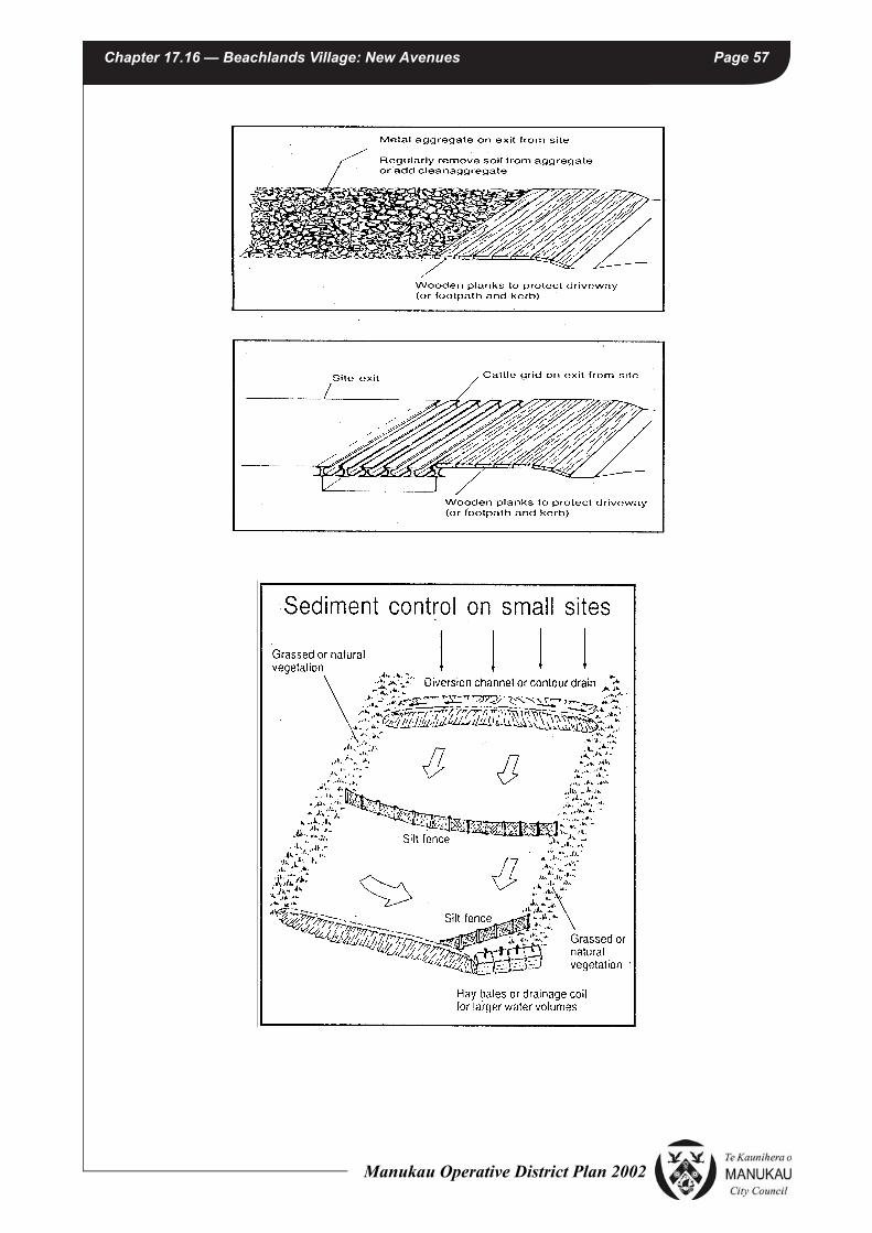
Chapter 17.16 — Beachlands Village: New Avenues Page 57
Manukau Operative District Plan 2002

Chapter 17.16 — Beachlands Village: New Avenues Page 58
EXPLANATION
This Appendix covers smaller scale earthworks that are Permitted Activities in relation to the district plan. Apart from building platform formation, such ‘small site’ earthworks are generally for the purpose of driveways, landscaping, paving, or tracking for rural tracks. Small site activities are of concern if no erosion or sediment controls are in place because any sediment generated eventually discharges onto nearby properties, to waterways, or to drains and stormwater systems.
Depending on the location of these works, they can have a direct influence on the receiving environment, an effect that is compounded by the cumulative impact of many operations. In most cases the volume of sediment discharges may be minor, however, it is the cumulative effects that have the potential to be significant to particular environmental qualities. For example, after the Auckland Regional Council has consented earthworks of a 100 lot subdivision, accommodate house platforms, driveways, paths etc. The impact of one property owner re-earthworking their site without proper controls is minor however, the cumulative impacts from 100 property owners re-earthworking without controls can be significant in terms of sediment generated. It is this cumulative effect that is of most concern.
Manukau Operative District Plan 2002

Chapter 17.16 — Beachlands Village: New Avenues Page 59
Appendix B
LANDSCAPE BUFFER AREA PLANTING PLAN AND PLANTING SCHEDULE
20 June 2012 | Schematic Design
SK-001Beachlands Landscape BufferBeachlands | Auckland
1:2000 at A3
0 5 20 50mm
OVERALL PLANTING PLAN
Existing treesLarge trees
View corridor maintained through landscape buffer
Medium to large treesMedium treesSmall treesUnderstory plantingExisting power poles
Refer planting plan for example
Refer planting plan for example
15m wide planted buffer
20 June 2012 | Schematic Design
SK-002Beachlands Landscape BufferBeachlands | Auckland
EXAMPLE PLANTING PLAN - TYPICAL AREAS
1:1500 at A3
0 1 5 10m
Liquidambar styracifluaPodocarpus totaraVitex lucens
Pyrus calleryana Dacrycarpus cupressinum Pyrus calleryanaDacrycarpus cupressinum
Corynocarpus laevigatusDacrycarpus dacrydiodes Quercus coccinea Dacrycarpus dacrydiodes Cedrus atlantica Quercus palustrisSophora microphylla
Metrosideros excelsa
Corynocarpus laevigatus Quercus coccinea Quercus robur ‘Fastigiata’
View corridor maintained through landscape buffer
Lower story species mix - Pittosporum crassifolium, Leptospermum ‘Copper Sheen’, Pseudopanax laetus, Pseudopanax arboreus, Hoheria populnea, Dodonea viscosa
Metrosideros excelsa Existing Trees
15m wide planted buffer
Manukau Operative District Plan 2002

Chapter 17.16 — Beachlands Village: New Avenues Page 60
20 June 2012 | Schematic Design
SK-004Beachlands Landscape BufferBeachlands | Auckland
PLANTING SCHEDULE
Manukau Operative District Plan 2002