
Chapter 1: Part J - Byron Shire€¦ · Draft Development Control Plan 2010 – Chapter 1 Part J...
27
Chapter 1: Part J Coastal Erosion Lands
Transcript of Chapter 1: Part J - Byron Shire€¦ · Draft Development Control Plan 2010 – Chapter 1 Part J...

Chapter 1: Part J
Coastal Erosion Lands

Draft Development Control Plan 2010 – Chapter 1 Part J – Coastal Erosion LandsAdopted 2 August 2018 Effective 23 August 2018
Document HistoryDoc No. Date Amended Details Comments eg Resolution No.
#312309 14 October 2010 Res 10-696 - to create Draft DCP 2010 for public exhibition
#1017143 Draft DCP 2010 Part J (public exhibition copy)
#1068732 14 March 2011 Adopted Res 11-169 - Format changes applied
E2018/42848 19 April 2018 Res 18-207 - Draft DCP 2010 Part J (public exhibition copy)
E2018/56689 3 July 2018 Draft DCP 2010 Part J (Submissions Report Copy)
E2018/69707 2 August 2018 Adopted Res 18-454

Ch1 Page J1
Draft Development Control Plan 2010 – Chapter 1 Part J – Coastal Erosion LandsAdopted 2 August 2018 Effective 23 August 2018
PART J – COASTAL EROSION LANDS
J1. INTRODUCTION ...................................................................................................................................3What is the purpose of this Part?...............................................................................................................3What are the Objectives of this Part? ........................................................................................................3
J2. DEVELOPMENT STANDARDS ............................................................................................................4J2.1 Element – Precinct 1 - from the Beach Escarpment to the Immediate Impact Line.......................4J2.2 Element – Precinct 2 - Between The Immediate Impact Line(D) And The 50 Year Erosion Line(D) 5J2.3 Element – Precinct 3 - between the 50 Year and 100 Year Erosion Lines(D).................................7J2.4 Element – Servicing .......................................................................................................................7J2.5 Element – Beach Protection ..........................................................................................................7J2.6 Element – Subdivision of Land ......................................................................................................8
COASTAL EROSION DEVELOPMENT CONTROL PLANS ........................................................................................9Map 1 of 17................................................................................................................................................9Map 2 of 17................................................................................................................................................9Map 3 of 17..............................................................................................................................................10Map 4 of 17..............................................................................................................................................11Map 5 of 17..............................................................................................................................................13Map 6 of 17..............................................................................................................................................14Map 7 of 17..............................................................................................................................................15Map 8 of 17..............................................................................................................................................16Map 9 of 17..............................................................................................................................................17Map 10 of 17............................................................................................................................................18Map 11 of 17............................................................................................................................................19Map 12 of 17............................................................................................................................................20Map 13 of 17............................................................................................................................................21Map 14 of 17............................................................................................................................................21Map 15 of 17............................................................................................................................................23Map 16 of 17............................................................................................................................................24Map 17 of 17............................................................................................................................................25
Note: (D) = definition included in Chapter 1 Part A7 of this DCP

Ch1 Page J2
Draft Development Control Plan 2010 – Chapter 1 Part J – Coastal Erosion LandsAdopted 2 August 2018 Effective 23 August 2018
This page has been intentionally left blank

Ch1 Page J3
Draft Development Control Plan 2010 – Chapter 1 Part J – Coastal Erosion LandsAdopted 2 August 2018 Effective 23 August 2018Note: (D) = definition included in Chapter 1 Part A7 of this DCP
J1. INTRODUCTION
What is the purpose of this Part?The purpose of this Part of the DCP is to provide advice, guidelines and development standards addressing coastal hazard issues in Byron Shire. This Part of the DCP applies to land affected by predicted coastal erosion and coastal hazards as defined on Maps provided to Council by the NSW Department of Land and Water Conservation.
What are the Objectives of this Part?
The Objectives of this Part of the DCP are:
- To make provision for the orderly and economic development of land within the coastal erosion zones.
- To ensure that such development is carried out in a manner which does not adversely affect coastal processes and which will not be adversely affected by coastal processes.
- To provide guidelines for determination of the merits of development on coastal lands as required by section 79C(a)(iv) of the Environmental Planning and Assessment Act 1979.
Ch1 Page J4
Draft Development Control Plan 2010 – Chapter 1 Part J – Coastal Erosion LandsAdopted 2 August 2018 Effective 23 August 2018Note: (D) = definition included in Chapter 1 Part A7 of this DCP
J2. DEVELOPMENT STANDARDS
J2.1 Element – Precinct 1 - from the Beach Escarpment to the Immediate Impact LineElement ObjectiveTo ensure the impact of coastal processes on potential development is minimised by limiting development and ensuring any development is only temporary.
Performance CriteriaNew buildings or works are to be temporary and able to be readily removed in the event of coastal erosion.
Development that is of a community nature, which relates to the use of the beachfront, may be considered, provided that any building is easily removable and does not require a major extension to a service main.
Where vacant urban-sized lots exist wholly within this precinct, the location of unregistered mobile homes as defined by the Local Government (Manufactured Home Estates, Caravan Parks, Camping Grounds and Moveable Dwellings) Regulation 2005 and as further described in this DCP, may be considered. These may comprise more than one unit, but all units must be capable of separation and relocation by four wheel drive car (rather than truck) prior to damage by the sea.
Erection of sacrificial structures, such as decks, may be possible where these do not prejudice relocation of other building sections. All elements, including decks, foundations and supports must be removed from the site(D) prior to damage by the sea.
Extensions or alterations to existing buildings in Precinct 1 must be limited to minor works only, and must be capable of swift removal or demolition if coastal processes threaten the development.
Prescriptive measures1. No building is to be located with 20 metres of the erosion escarpment.
2. Dwellings(D) and component modules be single storey(D) only and of minimal practical floor level, except where a minimum floor level is required in flood prone areas in which case an elevated floor level may be permitted.
3. Dwellings(D) must be entirely modular in construction, apart from sacrificial elements such as decks. Removable panels or similar componentry must not be used as structural elements, other than to provide screening to open space or car parking areas.
4. Dwellings(D) must consist of no more than three (3) modules. Each module must satisfy the following specifications:a) Maximum width: 4.6mb) Maximum height: 4.4m when loaded for towingc) Maximum weight: 5000kg including towing equipment (engineers
certification required).
5. Development proposals must include complete details of the removal procedure to ensure relocation can be practically achieved in 12 hours. Relocation procedures must be permanent, fail safe and require little maintenance. This must include:a) Identification of a removal route and destination outside Precinct 1 b) a method of resiting the modules after removal (such as restumping) and any
resources necessary for resiting, such as spare axle sets or mounting blocks;

Ch1 Page J5
Draft Development Control Plan 2010 – Chapter 1 Part J – Coastal Erosion LandsAdopted 2 August 2018 Effective 23 August 2018Note: (D) = definition included in Chapter 1 Part A7 of this DCP
c) use of not more than one 4WD vehicle for the entire relocation procedure (more may be used in practice but relocation must not rely on more than one being available);
d) manoeuvring details, including turning templates for laden vehicles to exit the site(D) and provision of sufficient hard surface area to accommodate manoeuvring;
e) removal of any obstacles on-site or en-route; f) certification by a practicing structural engineer that each module is stable and
safe under towing conditions, andg) removal of all elements, including decks, foundations and supports .
6. The relocation procedure must not require equipment reliant on mains electricity, such as power tools or winches, and must require no more than three people to achieve all necessary tasks.
7. All equipment required for the relocation procedure must be stored on-site and under cover, and maintained in a sound working condition at all times. The relocation procedure must be documented and stored on-site.
Existing BuildingsIn this clause, "gross floor area"(D) means the sum of all the floor plan areas(D) of a building, where "floor plan area"(D) has the meaning ascribed to it in Part C of this plan (Residential Development).
Extensions or alterations to existing buildings will be considered on their merits. Consideration will be given to the location of the erosion escarpment, the type of building involved and access to the site(D). Alterations or extensions will be considered where there will be no adverse effect on the ability of the building to be removed in an emergency. Generally extensions to existing buildings will be limited to:
(a) where the gross floor area(D) of the existing building is less than 100 m2 - extensions that will make the gross floor area(D) no greater than 100 m2;
(b) where the gross floor area(D) of the existing building is 100 m2 or more - 10% of the gross floor area(D) of the existing building at the date of commencement,
providing that only one such extension per building will be permitted since 1989.
Where an existing building is destroyed totally or partially through accident or damage caused by other than coastal processes, the building may be repaired or rebuilt so that:
(a) the total floor area of the rebuilt or repaired building is no greater than the total floor area before the damage occurred;
(b) the repairs or rebuilding have no detrimental effect on the ability of the building to be relocated in an emergency;
(c) where possible, the building is relocated at the time of rebuilding or repair to a position on the site(D) as far as possible from the erosion escarpment; and
(d) the repairs or rebuilding are effected within 12 months of the date when the damage occurred.
J2.2 Element – Precinct 2 - Between The Immediate Impact Line(D) And The 50 Year Erosion Line(D)
Element ObjectiveTo ensure the impact of coastal processes on potential development is minimised by ensuring any development is readily relocated as the erosion escarpment nears the development.
Ch1 Page J6
Draft Development Control Plan 2010 – Chapter 1 Part J – Coastal Erosion LandsAdopted 2 August 2018 Effective 23 August 2018Note: (D) = definition included in Chapter 1 Part A7 of this DCP
Performance CriteriaDevelopment in Precinct 2 must be designed to be relocate or demolished, or to cease operation, should the erosion escarpment come within 50 metres.
Prescriptive measuresDevelopment within this precinct will be granted on the understanding that any consent granted will be subject to the proviso that must the erosion escarpment come within 50 metres of any building then the development consent will cease.
If the development consent does cease then the owner of the land will be responsible for the removal of any or all buildings from the site(D), or, where possible, to a location on the site(D) further than 50 metres from the erosion escarpment. Prior to lodging an application with Council, the developer of the land must determine whether buildings are to be relocatable or demolished, should the consent cease.
Notwithstanding the above, all Class 1 residential buildings (dwelling-houses(D)) must be relocatable. Extensions to existing dwellings(D) may also be required to be demountable, taking into consideration the additional floor space proposed and the likely effect of the extension on the ability of the building to be relocated in an emergency.
The dwelling-house(D) must be designed and constructed so that it can be easily removed from the site(D) by road vehicle. The plans of the building must include an adequate description of the removal procedures.
The dwelling(D) must be located so as to maximise as far as practicable the distance from the nearest point of the building to the seaward boundary of the site(D).
Conditions of consent likely to apply to dwellings(D) on land within Precinct 2 are as follows:
a) (Prior to issue of a Construction Certificate) A certificate is to be provided from a practising structural engineer as to the adequacy of this building to be easily dismounted and readily removed from the site(D) by road vehicle.
b) (Prior to issue of a Construction Certificate) A restriction as to user must be placed on the title pursuant to the provisions of section 88E of the Conveyancing Act 1919, stating:
“The subject land and any improvements erected thereon must not be used for the purpose of (land use) in the event that the erosion escarpment, as defined by the Works and Services Director of the Council of the Shire of Byron from time to time, comes to within 50 metres of any buildings or any part thereof at any time erected on the said land."
c) Subsequent to any approval being given for a relocatable dwelling(D), no works must be carried out on the property which might hinder the ready relocation of the building. Such works might include the construction of walls, fences, screens, enclosures, brick veneering, landscaping or the fixing of joints or structural members by welding or other means.
d) This development consent must cease if at any time the erosion escarpment, as defined by the Works and Services Director of the Council of the Shire of Byron, comes to within 50 metres of any building associated with this development. The owner of the land must then remove that building.

Ch1 Page J7
Draft Development Control Plan 2010 – Chapter 1 Part J – Coastal Erosion LandsAdopted 2 August 2018 Effective 23 August 2018Note: (D) = definition included in Chapter 1 Part A7 of this DCP
J2.3 Element – Precinct 3 - between the 50 Year and 100 Year Erosion Lines(D)
Element ObjectiveTo ensure the impact of coastal processes on potential development is minimised by ensuring any development ceases as the erosion escarpment nears the development.
Performance CriteriaDevelopment in Precinct 3 must be designed to be relocate or demolished, or to cease operation, should the erosion escarpment come within 50 metres.
Prescriptive measuresDevelopment within this precinct will be considered on the understanding that any consent granted will be subject to the proviso that should the erosion escarpment come within 50 metres of any building then the development consent will cease.
If the development consent does cease then the owner of the land will be responsible for the removal of all buildings.
The option of demolition as the means of removal will be available to all buildings including Class 1 residential buildings.
Prior to the issue of a Construction Certificate a restriction as to user must be placed on the title pursuant to the provisions of section 88E of the Conveyancing Act 1919, stating:
“The subject land and any improvements erected thereon must not be used for the purpose of (land use) in the event that the erosion escarpment as defined by the Works and Services Director of the Council of the Shire of Byron from time to time comes to within 50 metres of any buildings or any part thereof at any time erected on the said land’.
J2.4 Element – ServicingElement ObjectiveTo define the circumstances in which public utility services may be provided to development which is potentially threatened by coastal processes.
Performance CriteriaVehicular access, water, sewerage, electricity, telephone and other services must be located so as to minimise the impact from the sea.
Prescriptive measuresAll services must be provided from the landward side of the development such that the building is between the services and the erosion escarpment.
J2.5 Element – Beach ProtectionElement ObjectiveTo ensure that works proposed by property owners to protect land from coastal processes will not have adverse effects on other land or on coastal processes.
Performance CriteriaAny work proposed by individual property owners to protect land from erosion must be designed to ensure that the work will not cause adverse impacts on other lands or on coastal processes.
Prescriptive measures
Ch1 Page J8
Draft Development Control Plan 2010 – Chapter 1 Part J – Coastal Erosion LandsAdopted 2 August 2018 Effective 23 August 2018Note: (D) = definition included in Chapter 1 Part A7 of this DCP
Any work carried out by individual property owners to protect land from erosion will require the consent of Council.
Council will consider consent for such works only where such works will have no adverse effect on any adjoining properties or on any coastal processes.
Rock, concrete and like hard materials must not be used for the construction of beach protection works.
J2.6 Element – Subdivision of LandElement Objective
Restrict the intensity of development within locations adversely affected by coastal processes.
Performance Criteria
Development will not be considered where it would result in the creation of vacant land capable of being developed for residential purposes.
Prescriptive Measures
Council will not consent to the subdivision of land in Zone No 7 (f2)—(Urban Coastal Lands (f2) Zone) that is located within Precincts 1 and 2 other than:
(a) subdivision of an existing lawfully erected building (or buildings) under the Strata Schemes Development Act 2015, where no vacant lots result from the subdivision; or
(b) a subdivision to excise an allotment that is, or that the Council is satisfied is intended to be, used for a public purpose; or
(c) a subdivision that, in the opinion of the Council, is only a boundary adjustment where no additional lots are created.

Ch1 Page J9
Draft Development Control Plan 2010 – Chapter 1 Part J – Coastal Erosion LandsAdopted 2 August 2018 Effective 23 August 2018Note: (D) = definition included in Chapter 1 Part A7 of this DCP
Coastal Erosion Development Control Plans
Map 1 of 17

Ch1 Page J10
Draft Development Control Plan 2010 – Chapter 1 Part J – Coastal Erosion LandsAdopted 2 August 2018 Effective 23 August 2018Note: (D) = definition included in Chapter 1 Part A7 of this DCP
Map 2 of 17

Ch1 Page J11
Draft Development Control Plan 2010 – Chapter 1 Part J – Coastal Erosion LandsAdopted 2 August 2018 Effective 23 August 2018Note: (D) = definition included in Chapter 1 Part A7 of this DCP
Map 3 of 17

Ch1 Page J12
Draft Development Control Plan 2010 – Chapter 1 Part J – Coastal Erosion LandsAdopted 2 August 2018 Effective 23 August 2018Note: (D) = definition included in Chapter 1 Part A7 of this DCP
Map 4 of 17
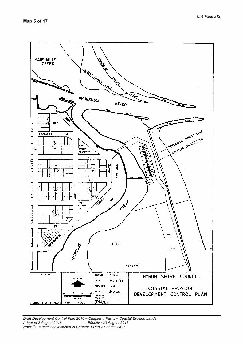
Ch1 Page J13
Draft Development Control Plan 2010 – Chapter 1 Part J – Coastal Erosion LandsAdopted 2 August 2018 Effective 23 August 2018Note: (D) = definition included in Chapter 1 Part A7 of this DCP
Map 5 of 17

Ch1 Page J14
Draft Development Control Plan 2010 – Chapter 1 Part J – Coastal Erosion LandsAdopted 2 August 2018 Effective 23 August 2018Note: (D) = definition included in Chapter 1 Part A7 of this DCP
Map 6 of 17

Ch1 Page J15
Draft Development Control Plan 2010 – Chapter 1 Part J – Coastal Erosion LandsAdopted 2 August 2018 Effective 23 August 2018Note: (D) = definition included in Chapter 1 Part A7 of this DCP
Map 7 of 17

Ch1 Page J16
Draft Development Control Plan 2010 – Chapter 1 Part J – Coastal Erosion LandsAdopted 2 August 2018 Effective 23 August 2018Note: (D) = definition included in Chapter 1 Part A7 of this DCP
Map 8 of 17

Ch1 Page J17
Draft Development Control Plan 2010 – Chapter 1 Part J – Coastal Erosion LandsAdopted 2 August 2018 Effective 23 August 2018Note: (D) = definition included in Chapter 1 Part A7 of this DCP
Map 9 of 17

Ch1 Page J18
Draft Development Control Plan 2010 – Chapter 1 Part J – Coastal Erosion LandsAdopted 2 August 2018 Effective 23 August 2018Note: (D) = definition included in Chapter 1 Part A7 of this DCP
Map 10 of 17

Ch1 Page J19
Draft Development Control Plan 2010 – Chapter 1 Part J – Coastal Erosion LandsAdopted 2 August 2018 Effective 23 August 2018Note: (D) = definition included in Chapter 1 Part A7 of this DCP
Map 11 of 17
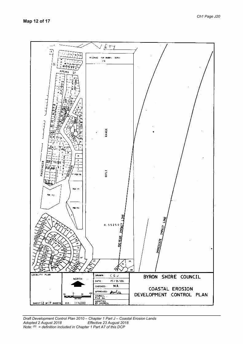
Ch1 Page J20
Draft Development Control Plan 2010 – Chapter 1 Part J – Coastal Erosion LandsAdopted 2 August 2018 Effective 23 August 2018Note: (D) = definition included in Chapter 1 Part A7 of this DCP
Map 12 of 17

Ch1 Page J21
Draft Development Control Plan 2010 – Chapter 1 Part J – Coastal Erosion LandsAdopted 2 August 2018 Effective 23 August 2018Note: (D) = definition included in Chapter 1 Part A7 of this DCP
Map 13 of 17

Ch1 Page J22
Draft Development Control Plan 2010 – Chapter 1 Part J – Coastal Erosion LandsAdopted 2 August 2018 Effective 23 August 2018Note: (D) = definition included in Chapter 1 Part A7 of this DCP
Map 14 of 17

Ch1 Page J23
Draft Development Control Plan 2010 – Chapter 1 Part J – Coastal Erosion LandsAdopted 2 August 2018 Effective 23 August 2018Note: (D) = definition included in Chapter 1 Part A7 of this DCP
Map 15 of 17

Ch1 Page J24
Draft Development Control Plan 2010 – Chapter 1 Part J – Coastal Erosion LandsAdopted 2 August 2018 Effective 23 August 2018Note: (D) = definition included in Chapter 1 Part A7 of this DCP
Map 16 of 17

Ch1 Page J25
Draft Development Control Plan 2010 – Chapter 1 Part J – Coastal Erosion LandsAdopted 2 August 2018 Effective 23 August 2018Note: (D) = definition included in Chapter 1 Part A7 of this DCP
Map 17 of 17