
chapter 1 - Introduction To The Oak Ridge Reservation · Oak Ridge Reservation Annual Site...
22
Oak Ridge Reservation Annual Site Environmental Report—2016 2016 Introduction to Oak Ridge Reservation 1-1 Chapter 1 - Introduction to the Oak Ridge Reservation The Oak Ridge Reservation (ORR) is a Federally owned 13,547 Hectare (ha) (32,671-acre) site located in Anderson and Roane counties in eastern Tennessee. The ORR is home to two major US Department of Energy (DOE) operating components, the Oak Ridge National Laboratory (ORNL) and the Y-12 National Security Complex (Y-12 Complex or Y-12). A number of other facilities are located on ORR, including the East Tennessee Technology Park (ETTP), site of a former gaseous diffusion plant that is undergoing environmental cleanup and transition to a private sector business and industrial park; the Oak Ridge Institute for Science and Education (ORISE) South Campus, which includes training facilities, laboratories, and support facilities; a variety of smaller government-owned, contractor-operated facilities involved in environmental cleanup; and the government-owned, government-operated Agent Operations Eastern Command of the National Nuclear Security Administration (NNSA) Office of Secure Transportation. The ORR was established in 1942 as part of the Manhattan Project for the purposes of enriching uranium, pioneering methods for producing and separating plutonium, and administering the nationwide World War II effort. ORR missions are continuing to evolve as it adapts to meet the changing basic and applied research and national security needs of the United States. Due to differing permit reporting requirements and instrument capabilities, various units of measurement are used in this report. The list of units of measure and conversion factors provided on pages xxxi and xxxii is intended to help readers convert numeric values presented here as needed for specific calculations and comparisons. Appendix A contains a glossary of technical terms that may be useful for understanding the terminology used in this report. 1.1 Background The Oak Ridge Reservation Annual Site Environmental Report (ASER) is prepared annually and presents environmental data to (1) characterize environmental performance, (2) summarize environmental occurrences reported during the year, (3) confirm compliance with environmental standards and requirements, and (4) highlight significant program activities. The report fulfills the requirement contained in DOE O 231.1B, Environment, Safety, and Health Reporting (DOE 2012) that an integrated annual site environmental report be prepared. The results summarized in this report are based on data collected before and continuing through calendar year 2016. This report is not intended to, nor does it, present the results of all environmental monitoring associated with the ORR. Data collected for other sites and regulatory purposes, such as environmental restoration and remedial investigation reports, waste management characterization sampling data, and environmental permit compliance data, are presented in other documents that have been prepared in accordance with applicable laws, regulations, policies, and/or guidance and are referenced here, as appropriate. Environmental monitoring on the ORR consists primarily of two major activities effluent monitoring and environmental surveillance. Effluent monitoring involves the collection and analysis of samples or measurements of solids, liquid and gaseous effluents at the points of release to the environment; these measurements allow the quantification and official reporting of contaminant levels, assessment of public exposures to radiation and chemicals, and demonstration of compliance with applicable standards and permit requirements. Environmental surveillance consists of direct measurements and collection and analysis of samples taken from the site and its environs exclusive
Transcript of chapter 1 - Introduction To The Oak Ridge Reservation · Oak Ridge Reservation Annual Site...
Oak Ridge Reservation Annual Site Environmental Report—20162016
Introduction to Oak Ridge Reservation 1-1
Chapter 1 - Introduction to the Oak Ridge Reservation
The Oak Ridge Reservation (ORR) is a Federally owned 13,547 Hectare (ha) (32,671-acre) site located in Anderson and Roane counties in eastern Tennessee. The ORR is home to two major US Department of Energy (DOE) operating components, the Oak Ridge National Laboratory (ORNL) and the Y-12 National Security Complex (Y-12 Complex or Y-12). A number of other facilities are located on ORR, including the East Tennessee Technology Park (ETTP), site of a former gaseous diffusion plant that is undergoing environmental cleanup and transition to a private sector business and industrial park; the Oak Ridge Institute for Science and Education (ORISE) South Campus, which includes training facilities, laboratories, and support facilities; a variety of smaller government-owned, contractor-operated facilities involved in environmental cleanup; and the government-owned, government-operated Agent Operations Eastern Command of the National Nuclear Security Administration (NNSA) Office of Secure Transportation.
The ORR was established in 1942 as part of the Manhattan Project for the purposes of enriching uranium, pioneering methods for producing and separating plutonium, and administering the nationwide World War II effort. ORR missions are continuing to evolve as it adapts to meet the changing basic and applied research and national security needs of the United States.
Due to differing permit reporting requirements and instrument capabilities, various units of measurement are used in this report. The list of units of measure and conversion factors provided on pages xxxi and xxxii is intended to help readers convert numeric values presented here as needed for specific calculations and comparisons. Appendix A contains a glossary of technical terms that may be useful for understanding the terminology used in this report.
1.1 Background
The Oak Ridge Reservation Annual Site Environmental Report (ASER) is prepared annually and presents environmental data to (1) characterize environmental performance, (2) summarize environmental occurrences reported during the year, (3) confirm compliance with environmental standards and requirements, and (4) highlight significant program activities. The report fulfills the requirement contained in DOE O 231.1B, Environment, Safety, and Health Reporting (DOE 2012) that an integrated annual site environmental report be prepared.
The results summarized in this report are based on data collected before and continuing through calendar year 2016. This report is not intended to, nor does it, present the results of all environmental monitoring associated with the ORR. Data collected for other sites and regulatory purposes, such as environmental restoration and remedial investigation reports, waste management characterization sampling data, and environmental permit compliance data, are presented in other documents that have been prepared in accordance with applicable laws, regulations, policies, and/or guidance and are referenced here, as appropriate. Environmental monitoring on the ORR consists primarily of two major activities effluent monitoring and environmental surveillance. Effluent monitoring involves the collection and analysis of samples or measurements of solids, liquid and gaseous effluents at the points of release to the environment; these measurements allow the quantification and official reporting of contaminant levels, assessment of public exposures to radiation and chemicals, and demonstration of compliance with applicable standards and permit requirements. Environmental surveillance consists of direct measurements and collection and analysis of samples taken from the site and its environs exclusive
Oak Ridge Reservation Annual Site Environmental Report—20162016
Introduction to Oak Ridge Reservation 1-2
of effluents; these activities provide information on contaminant concentrations in air, water, groundwater, soil, foods, biota, and other media. Environmental surveillance data support determinations regarding environmental compliance and, when combined with data from effluent monitoring, support chemical and radiation dose and exposure assessments of the potential effects of ORR operations, if any, on the local environment.
1.2 History of the Oak Ridge Reservation
The ORR area was first occupied by Native Americans more than 10,000 years ago, and members of the Overhill Cherokee tribe still lived in the East Tennessee region when European settlers arrived in the late 1700s. These settlers lived on farms or in four small communities called Elza, Robertsville, Scarborough, and Wheat. All but Elza were founded shortly after the Revolutionary War. In the early 1940s about 1,000 families inhabited the area.
In 1942, the area that was to become the ORR was selected for use in the Manhattan Project in part because the Clinch River provided ample supplies of water, the terrain featured linear and partitioned ridges, nearby Knoxville was a good source of labor, and the Tennessee Valley Authority (TVA) could supply ample amounts of needed electricity. About 3,000 residents received orders to vacate within weeks the homes and farms that their families had occupied for generations. The site's wartime name was "Clinton Engineering Works."
The workers' city, named Oak Ridge, was established on the reservation's northern edge. The city grew to a population of 75,000 and was the fifth largest in Tennessee; however, it was not shown on any map. At the Y-12 Complex south of the residential area, an electromagnetic separation method was used to separate uranium-235 (235U) from natural uranium. A gaseous diffusion plant, later known as K-25, was built on the reservation's western edge. Near the reservation's southwest corner, about 16 km (10 mi) from the Y-12 Complex, was a third facility known as X-10 or Clinton Laboratories where the Graphite Reactor was built. The X-10 facility was a pilot scale facility for the larger plutonium production facilities built at Hanford, Washington. Two years after World War II ended, Oak Ridge was shifted to civilian control under the authority of the US Atomic Energy Commission. In 1959, the city was incorporated and a city manager and city council form of government was adopted by the community.
Since that time, the missions of the three major ORR installations have continued to evolve and operations have adapted to meet the changing defense, energy, and research needs of the United States. Their current missions, as well as the missions of several smaller DOE facilities and activities on the ORR, are described in Section 1.4 of this document.
1.3 Site Description
1.3.1 Location and Population
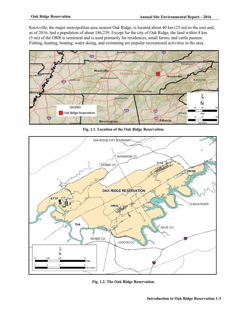
The ORR lies within the Great Valley of East Tennessee between the Cumberland and Great Smoky Mountains and is bordered by the Clinch River (Fig. 1.1). The Cumberland Mountains are 16 km (10 mi) to the northwest; the Great Smoky Mountains are 51 km (31.6 mi) to the southeast. The ORR encompasses about 13,221 ha (32,671 acres) of mostly contiguous land in Anderson and Roane counties that is owned by the federal government and under the management of DOE (Fig. 1.2). The population of the 10-county region surrounding the ORR is about 1,096,961, and about 2% of its labor force is employed on the ORR. The 2016 US Census population estimate for the official nine-county Knoxville metropolitan statistical area is 857,585. Other municipalities within about 30 km (18.6 mi) of the reservation include Oliver Springs, Clinton, Rocky Top, Lenoir City, Farragut, Kingston, and Harriman.
Oak Ridge Reservation Annual Site Environmental Report—2016
Introduction to Oak Ridge Reservation 1-3
Knoxville, the major metropolitan area nearest Oak Ridge, is located about 40 km (25 mi) to the east and, as of 2016, had a population of about 186,239. Except for the city of Oak Ridge, the land within 8 km (5 mi) of the ORR is semirural and is used primarily for residences, small farms, and cattle pasture. Fishing, hunting, boating, water skiing, and swimming are popular recreational activities in the area.
Fig. 1.1. Location of the Oak Ridge Reservation.
Fig. 1.2. The Oak Ridge Reservation.
Oak Ridge Reservation Annual Site Environmental Report - 2016
Introduction to Oak Ridge Reservation 1-4
1.3.2 Climate
The climate of the Oak Ridge region may be broadly classified as humid subtropical and is characterized by significant temperature changes between summer and winter. The 30-year mean temperature for 1986-2016 was 14.7°C (58.5°F). The average temperature for the Oak Ridge area in 2016 was 15.2°C (59.3°F). The coldest month is usually January, when temperatures average about 3.1°C (37.5°F). During 2016, January temperatures were the coldest, averaging 1.3°C (34.4°F). August was the warmest month, with average temperatures of 25.6°C (78.0°F). Monthly summaries of temperature averages, extremes, and 2016 values are provided in Appendix B, Table B.1.
Average annual precipitation in the Oak Ridge area for the 30-year period from 1986 to 2016 was 1,337.5 mm (52.64 in.), including about 21.3cm (8.4 in.) of snowfall annually (NOAA 2011). Total precipitation during 2016 as measured at meteorological tower (MT)2 was 1075 mm (42.31 in.). Monthly summaries of precipitation averages, extremes, and 2016 values are provided in Appendix B, Table B.1.
In 2016 wind speeds at ORNL Tower C/D (MT2), measured at 15 m (49 ft) above ground level (AGL), averaged 0.94 m/s (2.2 mph). This value remained unchanged for winds at 60 m (198 ft) AGL. The local ridge-and-valley terrain reduces average wind speeds at valley bottoms, resulting in frequent periods of calm or near calm conditions, particularly during clear early morning hours in weak synoptic weather environments. Wind direction frequencies with respect to 2016 precipitation hours for the ORR towers may be reviewed at http://metweb.ornl.gov/page7.htm under the header "2016 Annual Precipitation Wind Roses-Oak Ridge Reservation."
More detailed information on the climate of the Oak Ridge area is available in Oak Ridge ReservationPhysical Characteristics and Natural Resources (Parr and Hughes 2006) and in Appendix B of this document. A detailed analysis of wind patterns for the ORR was conducted from 2009 to 2011 and is documented in "Wind Regimes in Complex Terrain in the Great Valley of Eastern Tennessee" (Birdwell 2011), which may be reviewed online at https://www.ornl.gov/content/wind-regimes-complex-terrain-great-valley-eastern-tennessee.
1.3.3 Regional Air Quality
The US Environmental Protection Agency (EPA) Office of Air Quality Planning and Standards has set National Ambient Air Quality Standards (NAAQS) for key principal pollutants, which are called "criteria" pollutants. These pollutants are sulfur dioxide (SO2), carbon monoxide (CO), nitrogen dioxide (NO2), lead (Pb), ozone (O3), particulate matter (PM) with an aerodynamic diameter less than or equal to 10 µm (PM10), and fine PM with an aerodynamic diameter less than or equal to 2.5 µm (PM2.5). EPA evaluates NAAQS based on ambient (outdoor) levels of the criteria pollutants. Areas that satisfy NAAQS are classified as attainment areas, whereas areas that exceed NAAQS for a particular pollutant are classified as nonattainment areas for that pollutant.
The ORR is in Anderson and Roane counties. EPA has designated Anderson, Knox, and Blount counties as a nonattainment area for the PM2.5 air quality standard. EPA also designated the portion of Roane County surrounding the Kingston Steam Plant as a nonattainment area for PM2.5. The greater Knoxville and Oak Ridge area is classified as a NAAQS attainment area for all other criteria pollutants for which EPA has made attainment designations.
Oak Ridge Reservation Annual Site Environmental Report—2016
Introduction to Oak Ridge Reservation 1-5
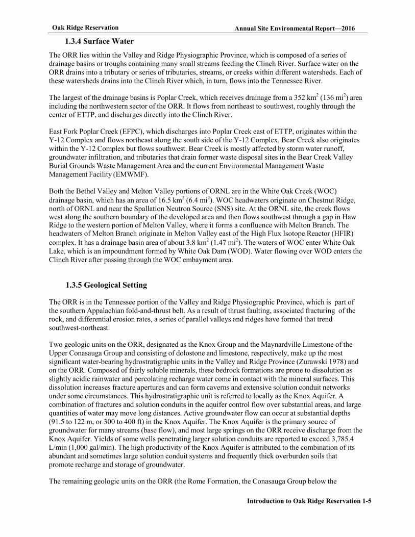
1.3.4 Surface Water
The ORR lies within the Valley and Ridge Physiographic Province, which is composed of a series of drainage basins or troughs containing many small streams feeding the Clinch River. Surface water on the ORR drains into a tributary or series of tributaries, streams, or creeks within different watersheds. Each of these watersheds drains into the Clinch River which, in turn, flows into the Tennessee River.
The largest of the drainage basins is Poplar Creek, which receives drainage from a 352 km2 (136 mi2) area including the northwestern sector of the ORR. It flows from northeast to southwest, roughly through the center of ETTP, and discharges directly into the Clinch River.
East Fork Poplar Creek (EFPC), which discharges into Poplar Creek east of ETTP, originates within the Y-12 Complex and flows northeast along the south side of the Y-12 Complex. Bear Creek also originates within the Y-12 Complex but flows southwest. Bear Creek is mostly affected by storm water runoff, groundwater infiltration, and tributaries that drain former waste disposal sites in the Bear Creek Valley Burial Grounds Waste Management Area and the current Environmental Management Waste Management Facility (EMWMF).
Both the Bethel Valley and Melton Valley portions of ORNL are in the White Oak Creek (WOC) drainage basin, which has an area of 16.5 km2 (6.4 mi2). WOC headwaters originate on Chestnut Ridge, north of ORNL and near the Spallation Neutron Source (SNS) site. At the ORNL site, the creek flows west along the southern boundary of the developed area and then flows southwest through a gap in Haw Ridge to the western portion of Melton Valley, where it forms a confluence with Melton Branch. The headwaters of Melton Branch originate in Melton Valley east of the High Flux Isotope Reactor (HFIR) complex. It has a drainage basin area of about 3.8 km2 (1.47 mi2). The waters of WOC enter White Oak Lake, which is an impoundment formed by White Oak Dam (WOD). Water flowing over WOD enters the Clinch River after passing through the WOC embayment area.
1.3.5 Geological Setting
The ORR is in the Tennessee portion of the Valley and Ridge Physiographic Province, which is part of the southern Appalachian fold-and-thrust belt. As a result of thrust faulting, associated fracturing of the rock, and differential erosion rates, a series of parallel valleys and ridges have formed that trend southwest-northeast.
Two geologic units on the ORR, designated as the Knox Group and the Maynardville Limestone of the Upper Conasauga Group and consisting of dolostone and limestone, respectively, make up the most significant water-bearing hydrostratigraphic units in the Valley and Ridge Province (Zurawski 1978) and on the ORR. Composed of fairly soluble minerals, these bedrock formations are prone to dissolution as slightly acidic rainwater and percolating recharge water come in contact with the mineral surfaces. This dissolution increases fracture apertures and can form caverns and extensive solution conduit networks under some circumstances. This hydrostratigraphic unit is referred to locally as the Knox Aquifer. A combination of fractures and solution conduits in the aquifer control flow over substantial areas, and large quantities of water may move long distances. Active groundwater flow can occur at substantial depths (91.5 to 122 m, or 300 to 400 ft) in the Knox Aquifer. The Knox Aquifer is the primary source of groundwater for many streams (base flow), and most large springs on the ORR receive discharge from the Knox Aquifer. Yields of some wells penetrating larger solution conduits are reported to exceed 3,785.4 L/min (1,000 gal/min). The high productivity of the Knox Aquifer is attributed to the combination of its abundant and sometimes large solution conduit systems and frequently thick overburden soils that promote recharge and storage of groundwater.
The remaining geologic units on the ORR (the Rome Formation, the Conasauga Group below the
Oak Ridge Reservation Annual Site Environmental Report—2016
Introduction to Oak Ridge Reservation 1-6
Maynardville Limestone, and the Chickamauga Group) are composed predominantly of shale, siltstones, and sandstones with a subordinate and locally variable amount of carbonate bedrock. These formations are predominantly composed of insoluble minerals such as clays and quartz that were derived from ancient continental erosion. Groundwater occurs in and moves through fractures in those bedrock units. Groundwater availability in such settings is dependent on the abundance and interconnectedness of fractures and the connection of fractures to sources of recharge, such as alluvial soils along streams that can provide some sustained infiltration. The shale and sandstone formations are the poorest aquifers in the Valley and Ridge Province (Zurawski 1978). Well yields are generally low in the Rome, Conasauga, and Chickamauga bedrock formations except in localized areas where carbonate beds may provide greater groundwater storage than adjacent clastic bedrock. Detailed information on ORR groundwater hydrology and flow is available in Oak Ridge Reservation Physical Characteristics and Natural Resources (Parr and Hughes 2006).
1.3.6 Natural, Cultural, and Historic Resources
The ORR contains a unique variety of natural, cultural, and historic resources. Ongoing efforts continue to focus on preserving the rich diversity of these resources.
1.3.7 Wetlands
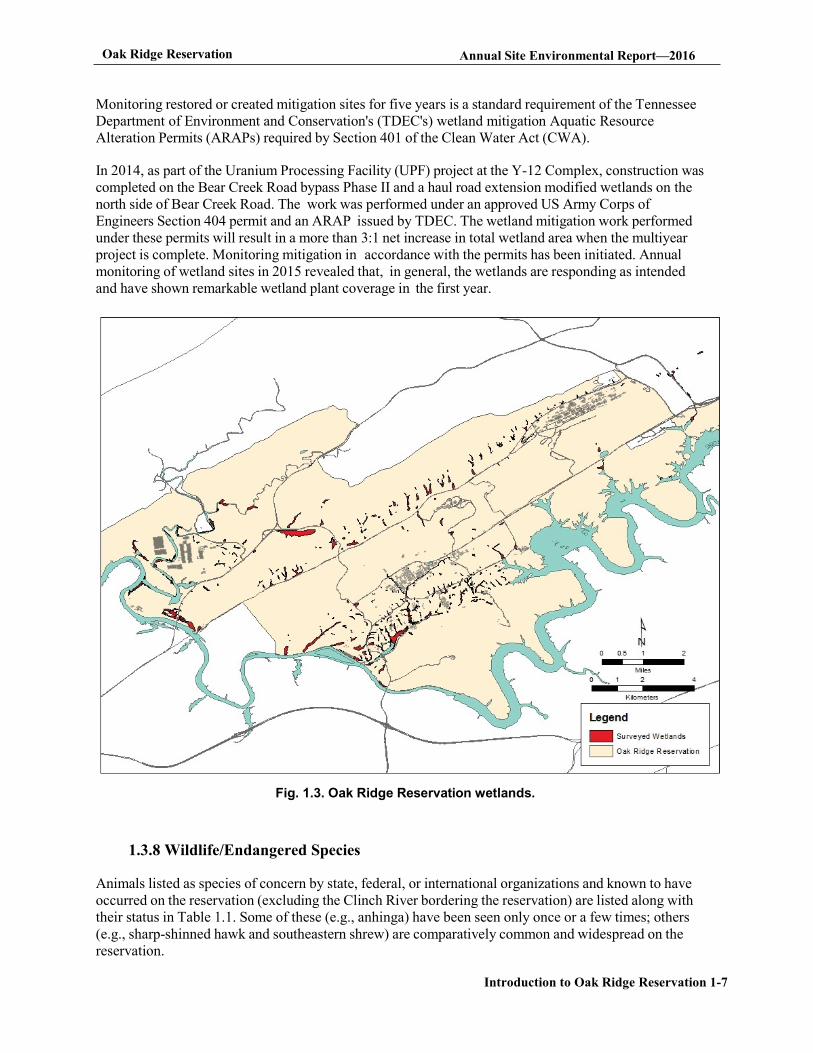
About 243 ha (600 acres) of wetlands have been identified on the ORR; most are classified as forested palustrine, scrub/shrub, and emergent wetlands. Wetlands occur across the ORR at low elevations, primarily in riparian zones of headwater streams and receiving streams and in the Clinch River embayments (Fig. 1.3). Wetlands identified to date range in size from several square meters at small seeps and springs to about 10 ha (25 acres) at White Oak Lake.
In 2016, the fifth and final year of postmitigation monitoring and reporting was completed on compensatory mitigation sites for the ORNL Parking Structure, which was constructed in 2011.The percentage of cover by species was measured for each plot. Information was also taken on any fauna present at the time of the survey. Five years of data, including the data collected during the year of mitigation, have shown excellent overall vegetationcoverage providing good quality habitat. Vegetation growing in the wetland in 2016 included both planted and volunteer plant species. There was a noted increase in black willow, sycamore, and green ash saplings. Climbing hempweed, an invasive species, continues to infiltrate the west end of the wetland; however, the spread is being controlled by the UT-Battelle grounds crew. A good variety of fauna was noted in and around the wetland including birds, frogs, and benthic macroinvertebrates.
Surveys of wetland resources presented in Identification and Characterization of Wetlands in the Bear Creek Watershed (Rosensteel and Trettin 1993), Wetland Survey of the X-10 Bethel Valley and Melton Valley Groundwater Operable Units at Oak Ridge National Laboratory, Oak Ridge, Tennessee (Rosensteel 1996), and Wetland Survey of Selected Areas in the Oak Ridge Y-12 Plant Area of Responsibility, Oak Ridge, Tennessee (Rosensteel 1997) serve as references to support wetland assessments for upcoming projects and activities. In addition, wetland maps have been developed for selected areas of the ORR in response to project-specific requirements. These are also consulted and verified by site inspections when appropriate. See Chapter 5, Section 5.3.12 for additional details.
Oak Ridge Reservation Annual Site Environmental Report—2016
Introduction to Oak Ridge Reservation 1-7
Monitoring restored or created mitigation sites for five years is a standard requirement of the Tennessee Department of Environment and Conservation's (TDEC's) wetland mitigation Aquatic Resource Alteration Permits (ARAPs) required by Section 401 of the Clean Water Act (CWA).
In 2014, as part of the Uranium Processing Facility (UPF) project at the Y-12 Complex, construction was completed on the Bear Creek Road bypass Phase II and a haul road extension modified wetlands on the north side of Bear Creek Road. The work was performed under an approved US Army Corps of Engineers Section 404 permit and an ARAP issued by TDEC. The wetland mitigation work performed under these permits will result in a more than 3:1 net increase in total wetland area when the multiyear project is complete. Monitoring mitigation in accordance with the permits has been initiated. Annual monitoring of wetland sites in 2015 revealed that, in general, the wetlands are responding as intended and have shown remarkable wetland plant coverage in the first year.
Fig. 1.3. Oak Ridge Reservation wetlands.
1.3.8 Wildlife/Endangered Species
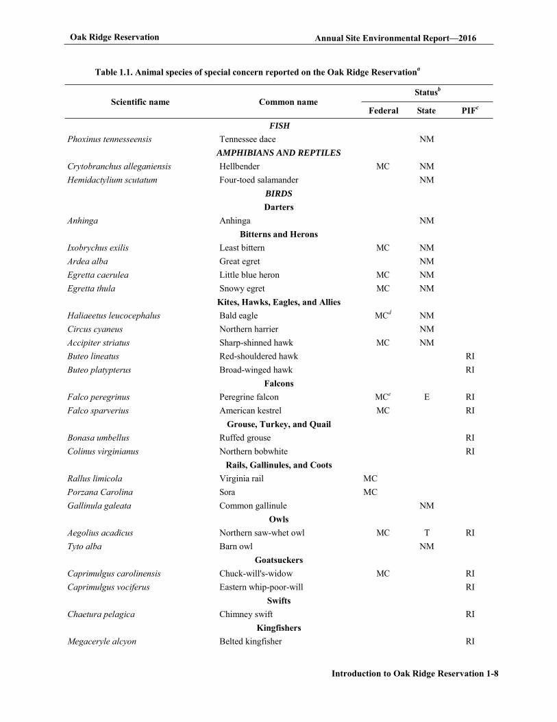
Animals listed as species of concern by state, federal, or international organizations and known to have occurred on the reservation (excluding the Clinch River bordering the reservation) are listed along with their status in Table 1.1. Some of these (e.g., anhinga) have been seen only once or a few times; others (e.g., sharp-shinned hawk and southeastern shrew) are comparatively common and widespread on the reservation.
Oak Ridge Reservation Annual Site Environmental Report—2016
Introduction to Oak Ridge Reservation 1-8
Table 1.1. Animal species of special concern reported on the Oak Ridge Reservationa
Statusb
Scientific name Common name
FISH
Federal State PIFc
Phoxinus tennesseensis Tennessee dace NM AMPHIBIANS AND REPTILES
Crytobranchus alleganiensis Hellbender MC NM Hemidactylium scutatum Four-toed salamander NM
BIRDS Darters
Anhinga Anhinga NM Bitterns and Herons
Ixobrychus exilis Least bittern MC NM Ardea alba Great egret NM Egretta caerulea Little blue heron MC NM Egretta thula Snowy egret MC NM
Kites, Hawks, Eagles, and Allies Haliaeetus leucocephalus Bald eagle MCd NM Circus cyaneus Northern harrier NM Accipiter striatus Sharp-shinned hawk MC NM Buteo lineatus Red-shouldered hawk RI Buteo platypterus Broad-winged hawk RI
Falcons Falco peregrinus Peregrine falcon MCe E RI Falco sparverius American kestrel MC RI
Grouse, Turkey, and Quail Bonasa umbellus Ruffed grouse RI Colinus virginianus Northern bobwhite RI
Rails, Gallinules, and Coots Rallus limicola Virginia rail MC Porzana Carolina Sora MC Gallinula galeata Common gallinule NM
Owls Aegolius acadicus Northern saw-whet owl MC T RI Tyto alba Barn owl NM
Goatsuckers Caprimulgus carolinensis Chuck-will's-widow MC RI Caprimulgus vociferus Eastern whip-poor-will RI
Swifts Chaetura pelagica Chimney swift RI
Kingfishers Megaceryle alcyon Belted kingfisher RI
Oak Ridge Reservation Annual Site Environmental Report—2016
Introduction to Oak Ridge Reservation 1-9
Table 1.1 Animal species of special concern reported on the Oak Ridge Reservationa (Continued)
Statusb
Scientific name Common name Federal State PIFc
Melanerpes erythrocephalus Woodpeckers
Red-headed woodpecker MC RI Sphyrapicus varius Yellow-bellied sapsucker MC NM Picoides pubescens Downy woodpecker RI Colaptes auratus Northern flicker RI
Contopus cooperi Tyrant Flycatchers
Olive-sided flycatcher MC NM RI Contopus virens Eastern wood-pewee RI Empidonax virescens Acadian flycatcher RI Empidonax trailii Willow flycatcher RI
Swallows Progne subis Purple martin RI Riparia Bank swallow RI Hirundo rustica Barn swallow RI
Titmice and Chickadees Poecile atricapillus Black-capped chickadee MC NM Poecile carolinensis Carolina chickadee RI
Nuthatches Sitta pusilla Brown-headed nuthatch MC RI
Wrens Troglodytes Winter wren RI Thryothorus ludovicianus Carolina wren RI
Kinglets, Gnatcatchers, and Thrushes Hylocichla mustelina Wood thrush MC RI
Thrashers and Mockingbirds Toxostoma rufum Brown thrasher RI
Waxwings Bombycilla cedrorum Cedar waxwing RI
Shrikes Lanius ludovicianus Loggerhead shrike MC NM RI
Vireos Vireo flavifrons Yellow-throated vireo RI Vireo solitaries Blue-headed vireo RI Vireo griseus White-eyed vireo RI
Wood Warblers Vermivora chrysoptera Golden-winged warbler MC NM RI Vermivora cyanoptera Blue-winged warbler MC RI Setophaga cerulea Cerulean warbler MC NM RI Setophaga discolor Prairie warbler MC RI
Oak Ridge Reservation Annual Site Environmental Report—2016
Introduction to Oak Ridge Reservation 1-10
Table 1.1 Animal species of special concern reported on the Oak Ridge Reservationa (Continued)
Statusb
Scientific name Common name Federal State PIFc
Setophaga dominica Yellow-throated warbler RI Mniotilta varia Black-and-white warbler RI Helmitheros vermivorum Worm-eating warbler MC RI Parkesia motacilla Louisiana waterthrush MC RI Protonotaria citrea Prothonotary warbler MC RI Geothlypis formosa Kentucky warbler MC RI Cardellina canadensis Canada warbler MC RI Setophaga citrina Hooded warbler RI Icteria virens Yellow-breasted chat RI Setophaga pinus Pine warbler RI Cardellina pusilla Wilson's warbler RI Setophaga magnolia Magnolia warbler RI Setophaga fusca Blackburnian warbler RI Setophaga pennsylvanica Chestnut-sided warbler RI Setophaga virens Black-throated green warbler RI
Tanagers Piranga olivacea Scarlet tanager RI Piranga rubra Summer tanager RI
Cardinals, Grosbeaks, and Allies Passerina cyanea Indigo bunting RI
Towhees, Sparrows, and Allies Pipilo erythrophthalmus Eastern towhee RI Spizella pusilla Field sparrow RI Ammodramus savannarum Grasshopper sparrow RI Pooecetes gramineus Vesper sparrow NM Ammodramus henslowii Henslow's sparrow MC NM RI Melospiza Georgiana Swamp sparrow RI
Blackbirds and Allies Dolichonyx oryzivorus Bobolink RI Sturnella magna Eastern meadowlark RI
Finches and Allies Spinus tristis American goldfinch RI
MAMMALS Myotis grisescens Myotis sodalist
Gray bat Indiana batf
E E
Myotis septentrionalis Northern long-eared bat T Sorex longirostris Southeastern shrew NM Sorex cinereus Masked shrew NM Zapus hudsonius Meadow jumping mouse NM
Oak Ridge Reservation Annual Site Environmental Report—2016
Introduction to Oak Ridge Reservation 1-11
Table 1.1 Animal species of special concern reported on the Oak Ridge Reservationa (Continued)
a Land and surface waters of the Oak Ridge Reservation (ORR) exclusive of the Clinch River, which borders the ORR. b Status codes
E = endangered T = threatened MC = of management concern NM = in need of management ORR = Oak Ridge Reservation
RI = regional importance c Partners in Flight (PIF)-an international organization devoted to conserving bird populations in the Western Hemisphere. d The bald eagle was federally delisted effective August 8, 2007. e The peregrine falcon was federally delisted effective August 25, 1999. f A single specimen was captured in a mist net bordering the Clinch River in June 2013.
Birds, fish, and aquatic invertebrates are the most thoroughly surveyed animal groups on the ORR. Nevertheless, the only federally listed animal species that have been observed on the ORR in recent years have been mammals. Gray bats were observed over the Clinch River bordering the ORR in 2003 and over a pond on the ORR in 2004. Three gray bats were mist-netted outside a cave on the ORR in 2006. Several gray bats and one Indiana bat were also captured in mist nets bordering the Clinch River in June-July 2013. Northern long-eared bats, recently federally listed as threatened, are known to be present on the ORR their calls have been identified in various acoustic surveys of the reservation, and in 2013 their presence was confirmed when a number were captured in mist nets (McCracken et al. 2015).
Two-hundred twenty-nine species of birds have been recorded on the ORR and its boundary waters. These are the 228-species documented by Roy et al. (2014) and the cackling goose (Branta hutchinsii), which was recorded in eBird (Sullivan et al. 2009) at the ORNL Swan Pond in November 2014. Most of these species are afforded protection under the Migratory Bird Treaty Act and Executive Order (EO) 13186, Responsibilities of Federal Agencies to Protect Migratory Birds. DOE's 2013 updated memorandum of understanding on migratory birds with the US Fish and Wildlife Service (FWS) strengthens migratory bird conservation on the ORR through enhanced collaboration between DOE and FWS (DOE-FWS 2013). Breeding bird surveys were conducted at 79 points along nine routes on the ORR in 2014 for the Partners in Flight Program. Multiple public nature walks were held on the ORR in 2016, including a bird-specific American Woodcock and Falconry walk. ORR work on early succession habitat was selected to represent DOE in the 2015 Presidential Migratory Bird Federal Stewardship Award nominations. All known ORR bird records since 1950, as well as population trends for 32 species of birds, were documented in the technical manuscript Oak Ridge Reservation Bird Records and
Population Trends (Roy et al. 2014).
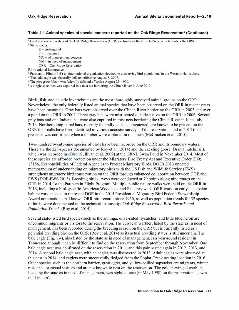
Several state-listed bird species such as the anhinga, olive-sided flycatcher, and little blue heron are uncommon migrants or visitors to the reservation. The cerulean warbler, listed by the state as in need of management, has been recorded during the breeding season on the ORR but is currently listed as a potential breeding bird on the ORR (Roy et al. 2014) as its actual breeding status is still uncertain. The bald eagle (Fig. 1.4), also listed by the state as in need of management, is a year-round resident in Tennessee, though it can be difficult to find on the reservation from September through November. One bald eagle nest was confirmed on the reservation in 2011, and this pair nested again in 2012, 2013, and 2014. A second bald eagle nest, with an eaglet, was discovered in 2013. Adult eagles were observed at this nest in 2014, and eaglets were successfully fledged from the Poplar Creek nesting location in 2016. Other species such as the northern harrier, great egret, and yellow-bellied sapsucker are migrants, winter residents, or casual visitors and are not known to nest on the reservation. The golden-winged warbler, listed by the state as in need of management, was sighted once (in May 1998) on the reservation, as was the Lincoln's
Oak Ridge Reservation Annual Site Environmental Report—2016
Introduction to Oak Ridge Reservation 1-12
sparrow (Melospiza lincolnii, in May 2014, no listed status). Barn owls have been known to nest on the reservation in the past and are still occasionally seen on the reservation.
Fig. 1.4. Bald eagle nest on the Oak Ridge Reservation. [Source: Jason Richards, ORNL photographer.]
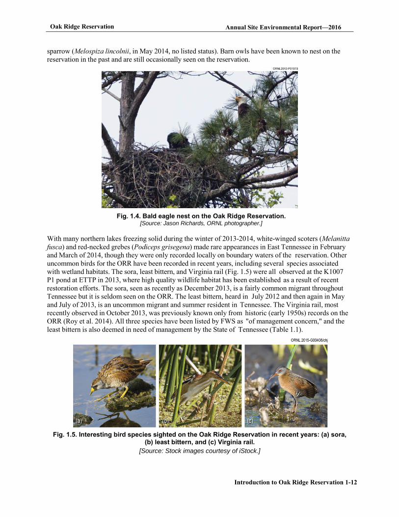
With many northern lakes freezing solid during the winter of 2013-2014, white-winged scoters (Melanitta fusca) and red-necked grebes (Podiceps grisegena) made rare appearances in East Tennessee in February and March of 2014, though they were only recorded locally on boundary waters of the reservation. Other uncommon birds for the ORR have been recorded in recent years, including several species associated with wetland habitats. The sora, least bittern, and Virginia rail (Fig. 1.5) were all observed at the K1007 P1 pond at ETTP in 2013, where high quality wildlife habitat has been established as a result of recent restoration efforts. The sora, seen as recently as December 2013, is a fairly common migrant throughout Tennessee but it is seldom seen on the ORR. The least bittern, heard in July 2012 and then again in May and July of 2013, is an uncommon migrant and summer resident in Tennessee. The Virginia rail, most recently observed in October 2013, was previously known only from historic (early 1950s) records on the ORR (Roy et al. 2014). All three species have been listed by FWS as "of management concern," and the least bittern is also deemed in need of management by the State of Tennessee (Table 1.1).
Fig. 1.5. Interesting bird species sighted on the Oak Ridge Reservation in recent years: (a) sora, (b) least bittern, and (c) Virginia rail.
[Source: Stock images courtesy of iStock.]
Oak Ridge Reservation Annual Site Environmental Report—2016
Introduction to Oak Ridge Reservation 1-13
One species of fish, the spotfin chub (Erimonax monachus), which is listed as threatened by both the state and the federal government, has been sighted and collected in the city of Oak Ridge and may be present on the ORR. The tangerine darter (Percina aurantiaca), a species listed by the state as in need of management, has also been recorded in close proximity to the ORR. The lake sturgeon (Acipenser fulvescens), state-listed as endangered, is known to inhabit the adjacent Clinch River. The Tennessee dace, listed by the state as being in need of management, has been found in the Bear Creek watershed, tributaries to the lower East Fork watershed, and Ish Creek and may occur in some sections of Grassy Creek upstream of Scientific Ecology Group, Inc., and International Technology Corporation at Clinch River kilometer 23 (e.g., south of west Bear Creek Road near Grassy Creek sampling point 1.9).
1.3.9 Threatened and Endangered Plants
Four plant species currently known to be on the ORR (spreading false foxglove, Appalachian bugbane, tall larkspur, and butternut) have been under review for listing at the federal level and were listed under the formerly used "C2" candidate designation. These species are now informally referred to as "special concern" species by the US Fish and Wildlife Service. (Note Appalachian bugbane is no longer listed by Tennessee and does not have official federal status; therefore, it does not appear in Table 1.2.)
Seventeen plant species occurring on the ORR are listed by the state as endangered, threatened, or of special concern and are listed in Table 1.2. An additional 10 threatened, endangered, or special concern species are known to occur in the area and, although currently unconfirmed on the ORR, have the potential to be present; these are also included in Table 1.2. Other plant populations are currently under study on the ORR, which may lead to additions to the table below.
The Tennessee Heritage Program scientific advisory committee met in 2012 to revise the state's Rare Plant List. Those changes are now official. This has reduced the number of state-protected species on the ORR by six. The protection of these six species on the ORR was a factor in their delisting.
Table 1.2. Vascular plant species listed by state or federal agencies and sighted/reported on or near the Oak Ridge Reservation, 2016
Species Common name Habitat on the ORR Status codea
Currently known to be or previously reported on the ORR Aureolaria patula Spreading false foxglove River bluff FSC, S Berberis canadensis American barberry Rocky bluff S Bolboschoenus fluviatilis River bulrush Wetland S Delphinium exaltatum Tall larkspur Barrens and woodlands FSC, E Diervilla lonicera Northern bush-honeysuckle Rocky river bluff T Draba ramosissima Branching whitlow-grass Limestone cliff S Elodea nuttallii Nuttall waterweed Pond, embayment S Eupatorium godfreyanum Godfrey's thoroughwort Dry woods edge S Fothergilla major Mountain witch-alder Woods T Helianthus occidentalis Naked-stem sunflower Barrens S Juglans cinerea Butternut Lake shore FSC, T Juncus brachycephalus Small-head rush Open wetland S Liparis loeselii Fen orchid Forested wetland T Panax quinquifolius American ginseng Rich woods S, CE
Oak Ridge Reservation Annual Site Environmental Report—2016
Introduction to Oak Ridge Reservation 1-14
Platanthera flava var. herbiola Tuberculed rein-orchid Forested wetland T Spiranthes lucida Shining ladies'-tresses Boggy wetland T Thuja occidentalis Northern white cedar Rocky river bluffs S
Rare plants that occur near and could be present on the ORR Agalinis auriculata Allium burdickii or A. tricoccomb
Earleaf false foxglove Ramps
Calcareous barren Moist woods
FSC, E S, CE
Lathyrus palustris Marsh pea Moist meadows S Liatris cylindracea Slender blazing star Calcareous barren T Lonicera dioica Mountain honeysuckle Rocky river bluff S Meehania cordata Heartleaf meehania Moist calcareous woods T Pedicularis lanceolata Swamp lousewort Calcareous wet meadow S Pseudognaphalium helleri Heller's catfoot Dry woodland edge S Pycnanthemum torrei Torrey's mountain-mint Calcareous barren edge S Solidago ptarmicoides Prairie goldenrod Calcareous barren E aStatus codes
CE = Status due to commercial exploitation. E = Endangered in Tennessee. FSC = Federal Special Concern; formerly designated as C2. See Federal Register, February 28, 1996. S = Special concern in Tennessee. T = Threatened in Tennessee.
bRamps have been reported near the ORR, but there is not sufficient information to determine which of the two species is present or whether the occurrence may have been the result of planting. Both species of ramps have the same state status.
Acronyms ORR = Oak Ridge Reservation
1.3.10 Historical and Cultural Resources
Efforts continue to preserve the ORR's rich prehistoric and historic cultural resources. Compliance with the National Historic Preservation Act (NHPA) on the ORR is maintained in conjunction with National Environmental Policy Act (NEPA) and Comprehensive Environmental Response, Compensation, and Liability Act (CERCLA) compliance. Pursuant to the Programmatic Agreement Among the Department of Energy Oak Ridge Office, The Tennessee State Historic Preservation Officer, and the Advisory Council on Historic Preservation Concerning Management of Historical and Cultural Properties at the Oak Ridge Reservation a Cultural Resource Management Plan was prepared. The DOE ORR Cultural Resource Management Plan provides a mechanism by which the DOE ORR will comply with cultural resource statutes, address cultural resources in the early process of its undertakings, and implement necessary protective measures for its cultural resources prior to initiating undertakings on the evaluated 254 structures of which forty-one are National Register of Historic Places (NRHP) Eligible Properties and six are included in the NRHP. Please keep the verbiage that state the reservation contains more than 45 known prehistoric sites. ETTP has 135 facilities that were eligible for inclusion on the National Register of Historic Places (NRHP), a National Park Service (NPS) program to identify, evaluate, and protect historic and archeological resources in the US, as well as numerous facilities that were not eligible for inclusion on the NRHP. To date, more than 800 facilities have been demolished. Artifacts of historical and/or cultural significance are identified before demolition and are catalogued in a database to aid in the historic interpretation of ETTP. The reservation contains more than 45 known prehistoric sites (primarily burial mounds and archeological evidence of former structures), more than 250 historic pre-World War II structures, 32 cemeteries, and several historically significant Manhattan Project-era structures.
The National Defense Authorization Act of 2015, passed by Congress and signed into law December 19,
Oak Ridge Reservation Annual Site Environmental Report—2016
Introduction to Oak Ridge Reservation 1-15
2014, included provisions authorizing the Manhattan Project National Historical Park. On November 10, 2015, the Manhattan Project National Historical Park was established with the execution of an agreement by the Secretaries of Energy and Interior. On the Oak Ridge Reservation, the boundaries of the National Park include the X-10 Graphite Reactor, buildings 9731 and 9204-3 at the Y-12 National Security Complex, and the K-25 Building Site at the East Tennessee Technology Park. The Park also includes facilities and lands in Los Alamos, New Mexico and Hanford, Washington.
• X-10 Graphite Reactor - The building has been registered with the National Register of HistoricPlaces since 1966, and has been open for public access in varying fashions since that time.Enhancing access and the visitor experience are part of DOE's objectives moving forward inimplementing the National Park.
• Y-12 National Security Complex - Buildings 9731 and 9204-3 were eligible for listing on theNational Register of Historic Places, and both are currently unavailable for regular public access.Irregular public access to both facilities has occurred as recently as Nov. 12, 2015, when DOEfacilitated public tours to both buildings in celebration of the establishment of the National Park.Enhancing safe access while protecting DOE's mission capabilities is part of DOE's objectivesmoving forward in implementing the National Park.
• K-25 Building Site - The K-25 Building site is already undergoing extensive historicinterpretation activities implemented separately and independently of the National Park. Enablingsafe access to the former site of the K-25 Building is part of DOE's objectives in moving forwardwith the implementation of the National Park. As part of the activities to establish the Park, DOEreleased the K-25 Virtual Museum, which details the history of the K-25 Gaseous Diffusion Plantthrough narrative and photographs and can be found at http //www.k-25virtualmuseum.org/.
In addition, seven historic ORR properties are individually listed in the NRHP
• Freels Bend Cabin• Graphite Reactor• New Bethel Baptist Church and Cemetery• Oak Ridge Turnpike Checking Station• George Jones Memorial Baptist Church and Cemetery• Bear Creek (Scarboro) Road Checking Station• Bethel Valley Road Checking Station
Although not yet listed in the NRHP, an area known as the Wheat Community African Burial Grounds was dedicated in June 2000, and a memorial monument was erected.
A memorandum of agreement (MOA) for the interpretation of historical properties at ETTP was signed in 2012 by DOE Oak Ridge Office (ORO), the State Historic Preservation Officer (SHPO), the Advisory Council on Historic Preservation (ACHP), the City of Oak Ridge, and the East Tennessee Preservation Alliance. The MOA is being implemented through planning for a museum that will highlight the historic aspects of ETTP and of the communities that were displaced during the construction of the site. Details are provided in Chapter 3, Sections 3.3.4 and 3.8.2. A final MOA was signed in August 2012 finalizing the aspects set forth in the mitigation plan. During 2013, a request for proposal was issued for a Professional Design Team and Museum Professional as specified in the MOA. Nine firms were prequalified, and the selection and award were executed April 1, 2014. The procurement process for the K-25 Virtual Museum web design firm was also begun in 2013 and awarded September 2, 2014. An MOA was signed by the US Department of Interior and DOE on November 10, 2016 creating the new Manhattan Project Historic National Park. The K-25 Virtual Museum website (K-25 Virtual Museum 2016) was launched in conjunction with the signing of the MOA.
Oak Ridge Reservation Annual Site Environmental Report—2016
Introduction to Oak Ridge Reservation 1-16
Two site-wide programmatic agreements among DOE ORO, SHPO, and ACHP concerning management of historical and cultural properties at ORNL and at Y-12 have been enforced since their respective approvals.
1.4 Oak Ridge Sites
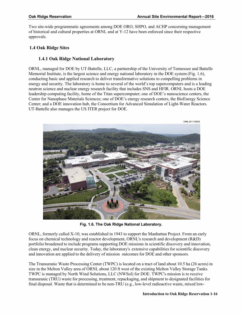
1.4.1 Oak Ridge National Laboratory
ORNL, managed for DOE by UT-Battelle, LLC, a partnership of the University of Tennessee and Battelle Memorial Institute, is the largest science and energy national laboratory in the DOE system (Fig. 1.6), conducting basic and applied research to deliver transformative solutions to compelling problems in energy and security. The laboratory is home to several of the world’s top supercomputers and is a leading neutron science and nuclear energy research facility that includes SNS and HFIR. ORNL hosts a DOE leadership computing facility, home of the Titan supercomputer; one of DOE’s nanoscience centers, the Center for Nanophase Materials Sciences; one of DOE’s energy research centers, the BioEnergy Science Center; and a DOE innovation hub, the Consortium for Advanced Simulation of Light-Water Reactors. UT-Battelle also manages the US ITER project for DOE.
Fig. 1.6. The Oak Ridge National Laboratory.
ORNL, formerly called X-10, was established in 1943 to support the Manhattan Project. From an early focus on chemical technology and reactor development, ORNL's research and development (R&D) portfolio broadened to include programs supporting DOE missions in scientific discovery and innovation, clean energy, and nuclear security. Today, the laboratory's extensive capabilities for scientific discovery and innovation are applied to the delivery of mission outcomes for DOE and other sponsors.
The Transuranic Waste Processing Center (TWPC) is located on a tract of land about 10.5 ha (26 acres) in size in the Melton Valley area of ORNL about 120 ft west of the existing Melton Valley Storage Tanks. TWPC is managed by North Wind Solutions, LLC (NWSol) for DOE. TWPC's mission is to receive transuranic (TRU) waste for processing, treatment, repackaging, and shipment to designated facilities for final disposal. Waste that is determined to be non-TRU (e.g., low-level radioactive waste, mixed low-
Oak Ridge Reservation Annual Site Environmental Report—2016
Introduction to Oak Ridge Reservation 1-17
level waste) is shipped to the Nevada National Security Site (NNSS) or other approved facilities.
DOE remains focused on disposing of a significant inventory of uranium-233 (233U) stored in Building 3019 at ORNL. This special nuclear material requires strict safeguards and security controls to protect against access. The 233U Project's objective is to address safeguards and security requirements, eliminate safety and nuclear criticality concerns, and safely dispose of the material. In 2015, DOE successfully resolved the concerns associated with the disposition of the Consolidated Edison Uranium Solidification Project (CEUSP) material. CEUSP originated from a 1960s research and development test of thorium and uranium fuel at Consolidated Edison's Indian Point 1 Nuclear Plant in New York. Isotek Systems LLC (Isotek) manages activities at the Building 3019 complex for DOE and is responsible for activities associated with processing, down-blending, and packaging the DOE inventory of 233U stored in the complex.
URS, CH2M Oak Ridge LLC (UCOR) is the DOE ORR cleanup contractor. The scope of UCOR activities at ORNL includes long-term surveillance, maintenance, and management of inactive waste disposal sites, structures, and buildings such as former reactors and isotope production facilities. Other activities include groundwater monitoring, TRU waste storage, and operation of the liquid low-level and process waste systems and the off-gas collection and treatment system.
1.4.2 The Y-12 National Security Complex
The original Y-12 Complex was constructed as part of the World War II Manhattan Project and began operations in November 1943. The first site mission was the separation of 235U from natural uranium by an electromagnetic separation process. At its peak in 1945, more than 22,000 workers were employed at the site.
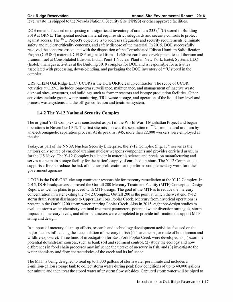
Today, as part of the NNSA Nuclear Security Enterprise, the Y-12 Complex (Fig. 1.7) serves as the nation's only source of enriched uranium nuclear weapons components and provides enriched uranium for the US Navy. The Y-12 Complex is a leader in materials science and precision manufacturing and serves as the main storage facility for the nation's supply of enriched uranium. The Y-12 Complex also supports efforts to reduce the risk of nuclear proliferation and performs complementary work for other government agencies.
UCOR is the DOE ORR cleanup contractor responsible for mercury remediation at the Y-12 Complex. In 2015, DOE headquarters approved the Outfall 200 Mercury Treatment Facility (MTF) Conceptual Design Report, as well as plans to proceed with MTF design. The goal of the MTF is to reduce the mercury concentration in water exiting the Y-12 Complex. Outfall 200 is the point at which the west end Y-12 storm drain system discharges to Upper East Fork Poplar Creek. Mercury from historical operations is present in the Outfall 200 storm water entering Poplar Creek. Also in 2015, eight pre-design studies to evaluate storm water chemistry, optimal treatment parameters, potential water diversion strategies, storm impacts on mercury levels, and other parameters were completed to provide information to support MTF siting and design.
In support of mercury clean-up efforts, research and technology development activities focused on the major factors influencing the accumulation of mercury in fish (fish are the major route of both human and wildlife exposure). Three lines of investigation for East Fork Poplar Creek were developed to (1) examine potential downstream sources, such as bank soil and sediment control, (2) study the ecology and how differences in food chain processes may influence the uptake of mercury in fish, and (3) investigate the water chemistry and flow characteristics of the creek and its influence.
The MTF is being designed to treat up to 3,000 gallons of storm water per minute and includes a 2-million-gallon storage tank to collect storm water during peak flow conditions of up to 40,000 gallons per minute and then treat the stored water after storm flow subsides. Captured storm water will be piped to
Oak Ridge Reservation Annual Site Environmental Report—2016
Introduction to Oak Ridge Reservation 1-18
a treatment facility located on an available site east of Outfall 200. Mercury treatment will be accomplished using chemical precipitation, clarification, and media filtration. Treated water will be discharged back into Upper East Fork Poplar Creek. The Outfall 200 MTF design incorporates flexibility and expandability of treatment processes for mercury if required in the future.
Understanding the movement of mercury in the East Fork Poplar Creek system was deemed essential to the development of new technologies and ultimately to the development of remedial options and strategies for the creek. Early studies have pointed to the importance of bank soils and sediments as a source of mercury to the creek, especially during high-flow events. Research is under way to examine potential technologies that may limit mercury erosion. Stream management changes-such as controlling nutrients or algae growth or managing fish populations-are also under investigation. In March 2015, scientists issued a report titled Mercury Remediation Technology Development for Lower East Fork Poplar Creek (ORNL/SPR-2014/645). This report offers science-based approaches and ideas for research and technology development activities that may lead to new mercury remediation projects.
Fig. 1.7. Y-12 National Security Complex.
1.4.3 East Tennessee Technology Park
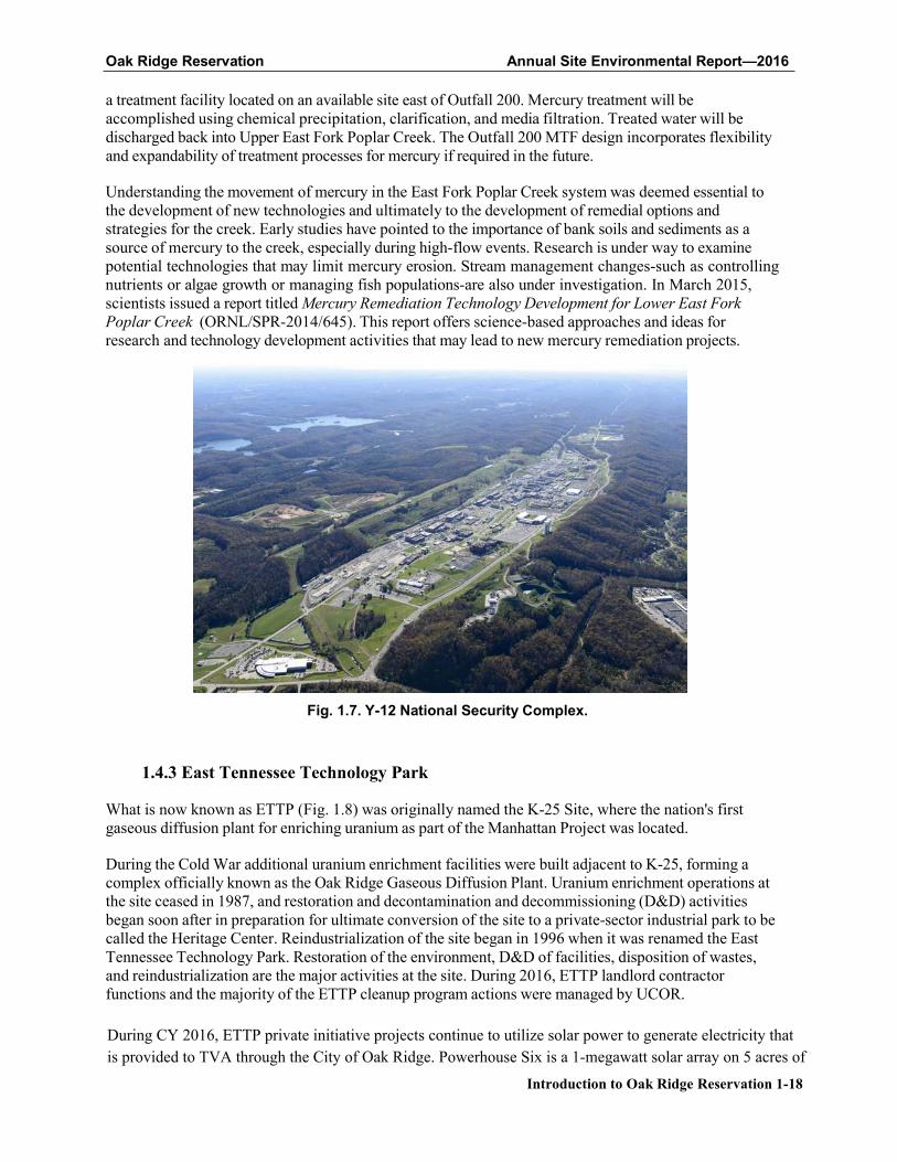
What is now known as ETTP (Fig. 1.8) was originally named the K-25 Site, where the nation's first gaseous diffusion plant for enriching uranium as part of the Manhattan Project was located.
During the Cold War additional uranium enrichment facilities were built adjacent to K-25, forming a complex officially known as the Oak Ridge Gaseous Diffusion Plant. Uranium enrichment operations at the site ceased in 1987, and restoration and decontamination and decommissioning (D&D) activities began soon after in preparation for ultimate conversion of the site to a private-sector industrial park to be called the Heritage Center. Reindustrialization of the site began in 1996 when it was renamed the East Tennessee Technology Park. Restoration of the environment, D&D of facilities, disposition of wastes, and reindustrialization are the major activities at the site. During 2016, ETTP landlord contractor functions and the majority of the ETTP cleanup program actions were managed by UCOR.
During CY 2016, ETTP private initiative projects continue to utilize solar power to generate electricity thatis provided to TVA through the City of Oak Ridge. Powerhouse Six is a 1-megawatt solar array on 5 acres of
Oak Ridge Reservation Annual Site Environmental Report—2016
Introduction to Oak Ridge Reservation 1-19
former DOE land and Brightfield 1 is a 200-kW array located on a 1-acre tract purchased from CROET.
Fig. 1.8. East Tennessee Technology Park.
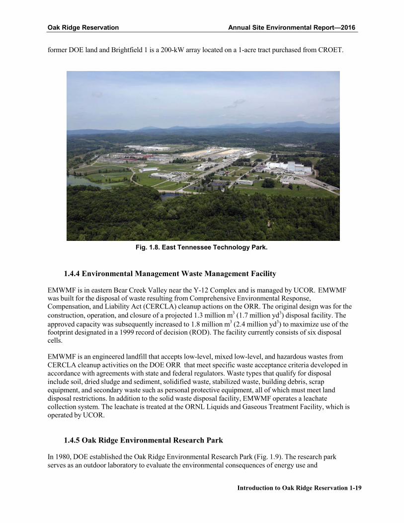
1.4.4 Environmental Management Waste Management Facility
EMWMF is in eastern Bear Creek Valley near the Y-12 Complex and is managed by UCOR. EMWMF was built for the disposal of waste resulting from Comprehensive Environmental Response, Compensation, and Liability Act (CERCLA) cleanup actions on the ORR. The original design was for the construction, operation, and closure of a projected 1.3 million m3 (1.7 million yd3) disposal facility. The approved capacity was subsequently increased to 1.8 million m3 (2.4 million yd3) to maximize use of the footprint designated in a 1999 record of decision (ROD). The facility currently consists of six disposal cells.
EMWMF is an engineered landfill that accepts low-level, mixed low-level, and hazardous wastes from CERCLA cleanup activities on the DOE ORR that meet specific waste acceptance criteria developed in accordance with agreements with state and federal regulators. Waste types that qualify for disposal include soil, dried sludge and sediment, solidified waste, stabilized waste, building debris, scrap equipment, and secondary waste such as personal protective equipment, all of which must meet land disposal restrictions. In addition to the solid waste disposal facility, EMWMF operates a leachate collection system. The leachate is treated at the ORNL Liquids and Gaseous Treatment Facility, which is operated by UCOR.
1.4.5 Oak Ridge Environmental Research Park
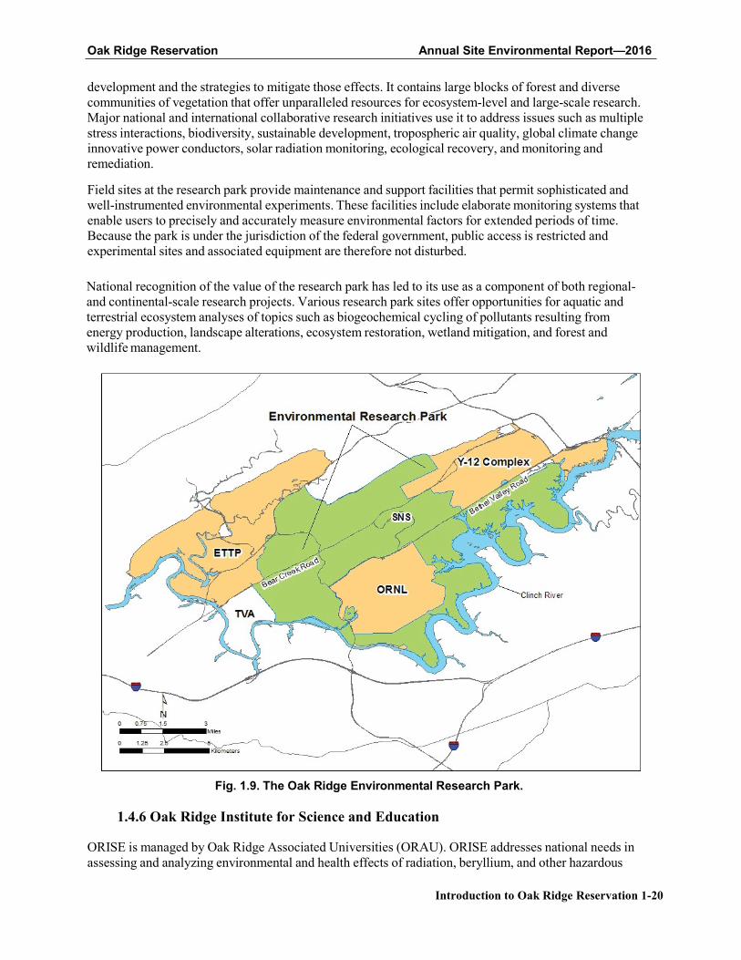
In 1980, DOE established the Oak Ridge Environmental Research Park (Fig. 1.9). The research park serves as an outdoor laboratory to evaluate the environmental consequences of energy use and
Oak Ridge Reservation Annual Site Environmental Report—2016
Introduction to Oak Ridge Reservation 1-20
development and the strategies to mitigate those effects. It contains large blocks of forest and diverse communities of vegetation that offer unparalleled resources for ecosystem-level and large-scale research. Major national and international collaborative research initiatives use it to address issues such as multiple stress interactions, biodiversity, sustainable development, tropospheric air quality, global climate change innovative power conductors, solar radiation monitoring, ecological recovery, and monitoring and remediation.
Field sites at the research park provide maintenance and support facilities that permit sophisticated and well-instrumented environmental experiments. These facilities include elaborate monitoring systems that enable users to precisely and accurately measure environmental factors for extended periods of time. Because the park is under the jurisdiction of the federal government, public access is restricted and experimental sites and associated equipment are therefore not disturbed.
National recognition of the value of the research park has led to its use as a component of both regional- and continental-scale research projects. Various research park sites offer opportunities for aquatic and terrestrial ecosystem analyses of topics such as biogeochemical cycling of pollutants resulting from energy production, landscape alterations, ecosystem restoration, wetland mitigation, and forest and wildlife management.
Fig. 1.9. The Oak Ridge Environmental Research Park.
1.4.6 Oak Ridge Institute for Science and Education
ORISE is managed by Oak Ridge Associated Universities (ORAU). ORISE addresses national needs in assessing and analyzing environmental and health effects of radiation, beryllium, and other hazardous
Oak Ridge Reservation Annual Site Environmental Report—2016
Introduction to Oak Ridge Reservation 1-21
materials; developing and operating medical and national security radiation emergency management and response capabilities; and managing education programs to help ensure a robust supply of scientists, engineers, and technicians to meet future science and technology needs. ORISE creates opportunities for collaboration through partnerships with other DOE facilities, federal agencies, academia, and industry in a manner consistent with DOE objectives and the ORISE mission.
ORISE is located in an area on the southeastern border of the ORR that from the late 1940s to the mid-1980s was part of an agricultural experiment station owned by the federal government and, until 1981, operated by the University of Tennessee. The site houses offices, laboratories, and storage areas for the ORISE program offices and support departments.
1.4.7 The National Nuclear Security Administration Office of Secure Transportation,
Agent Operations Eastern Command
Since 1947, DOE and its predecessor agencies have moved nuclear weapons, weapons components, special nuclear materials, and other important national security assets by commercial and government transportation modes. In the late 1960s, worldwide terrorism and acts of violence prompted a review of procedures for safeguarding these materials. As a result, a comprehensive new series of regulations and equipment was developed to enhance the safety and security of these materials in transit. Thus, modified and redesigned transport equipment was created to incorporate features that more effectively enhance self-protection and deny unauthorized access to the materials. Also during this time, the use of commercial transportation systems was abandoned and a totally federal operation was implemented. The organization within DOE NNSA responsible for this mission is the Office of Secure Transportation (OST).
The NNSA OST Agent Operations Eastern Command (AOEC) Secure Transportation Center and Training Facility is located on the ORR. NNSA OST AOEC is situated on about 723 ha (1,786 acres) of the ORR and operates under a user permit agreement with DOE ORO. NNSA OST AOEC implements its assigned mission transportation operations, maintains applicable fleet and escort vehicles, and continues extensive training activities for its federal agents.
1.5 References
Birdwell, Kevin Ray. 2011. "Wind Regimes in Complex Terrain of the Great Valley of Eastern Tennessee." PhD dissertation, University of Tennessee, May 2011.
DOE. 2012. Environment, Safety, and Health Reporting. DOE O 231.1B. Approved 06-27-11. US Department of Energy, Washington, DC.
DOE-FWS. 2013. "Memorandum of Understanding between the United States Department of Energy and the United States Fish and Wildlife Service Regarding Implementation of Executive Order 13186, 'Responsibilities of Federal Agencies to Protect Migratory Birds'." US Department of Energy and US Fish and Wildlife Service, Washington, DC; available online at https://energy.gov/sites/prod/files /2013/10/f3/Final%20DOE-FWS%20Migratory%20Bird%20MOU.pdf.
McCracken, M.K., N.R. Giffen, A.M. Haines, and J.W. Evans. 2016. Bat Species Distribution on the Oak
Ridge Reservation. ORNL/TM-2016/248, Oak Ridge National Laboratory, Oak Ridge, Tennessee. (Note Draft report; contact author for access.)
NOAA. 2011. Annual 2011 Local Climatological Data Report for Oak Ridge, Tennessee (Site KOQT). Published by the National Climatic Data Center, Asheville, North Carolina.
Parr, P.D. and J.F. Hughes. 2006. Oak Ridge Reservation Physical Characteristics and Natural
Resources. ORNL/TM-2006/110, Oak Ridge National Laboratory, Oak Ridge, Tennessee.
Rosensteel, B.A. 1996. Wetland Survey of the X-10 Bethel Valley and Melton Valley Groundwater
Oak Ridge Reservation Annual Site Environmental Report—2016
Introduction to Oak Ridge Reservation 1-22
Operable Units at Oak Ridge National Laboratory, Oak Ridge, Tennessee. ORNL/ER-350, Oak Ridge National Laboratory, Oak Ridge, Tennessee.
Rosensteel, B.A. 1997. Wetland Survey of Selected Areas in the Oak Ridge Y-12 Plant Area of
Responsibility, Oak Ridge, Tennessee. Y/ER-279, Y-12 National Security Complex, Oak Ridge, Tennessee.
Rosensteel, Barbara A. and Carl C. Trettin. 1993. Identification and Characterization of Wetlands in the
Bear Creek Watershed. Y/TS-1016, Oak Ridge National Laboratory, Oak Ridge, Tennessee.
Roy, W.K., N.R. Giffen, M.C. Wade, A.M. Haines, J.W. Evans, and R.T. Jett. 2014. Oak Ridge
Reservation Bird Records and Population Trends. ORNL/TM-2014/109, Oak Ridge National Laboratory, Oak Ridge, Tennessee.
Souza, Peter A., Glyn D. DuVall, and Melisa J. Hart. 2001. Cultural Resource Management Plan, DOE
Oak Ridge Reservation, Anderson and Roane Counties, Tennessee. DOE/ORO/2085. US Department of Energy, Washington, DC.
Sullivan, B.L., C.L. Wood, M.J. Iliff, R.E. Bonney, D. Fink, and S. Kelling. 2009. "eBird A Citizen- Based Bird Observation Network in the Biological Sciences." Biological Conservation 142, 2282- 2292.
Zurawski, A. 1978. Summary Appraisals of the Nation’s Ground-Water Resources—Tennessee Region. US Geological Survey Professional Paper 813-L.