CHAPTER -1 BACKGROUND AND EMERGING ISSUES TO INITIATE ...
45
CHAPTER -1 BACKGROUND AND EMERGING ISSUES TO INITIATE DRAFT COMPREHENSIVE DEVELOPMENT PLAN (CDP) PROPOSALS 1.1 Background Development planning seeks to achieve good quality development. An attempt has been made to prepare the comprehensive development of the area within the statutory framework of Act and Rules. As per Section 9 of the Orissa Development Authority Act 1982, it is the statutory duty of the development authority to prepare the Comprehensive Development Plan (CDP) considering the provisions of CHAPTER-III of the Orissa Development Authority Rules, 1983, and has to submit it to the State Government for its approval under Section 11 of the Act. The SDA has to follow the procedure regarding preparation and approval of CDP as mentioned in Section 12 of the Act. This Comprehensive Development Plan shall come into operation as per provisions of Section 13 of the Act. According to the Act, the Comprehensive Development Plan (CDP) shall, define the various zones into which the land covered by the Comprehensive Development Plan may be divided for the purpose of development and indicate the manner in which the land in each zone is proposed to be used and the stages by which any such development shall be carried out. It shall serve as a basic pattern of frame work within which the Zonal Development Plan of the various zones may be prepared. With the formation of the Sambalpur Development Authority (SDA), this would be the first attempt to visualize the area beyond the limits of Sambalpur and look towards holistic development of the Sambalpur including the adjoining areas of Burla, Hirakud and surrounding villages. The Sambalpur-Burla-Hirakud complex under the jurisdiction of SDA is located at 21°30’ North latitude and 84°0’ East longitude on the western belt of Orissa at a distance of about 325 kms from Bhubaneswar, the capital city. The SDA is responsible for planned development of this urban complex. As part of scope of work to prepare Comprehensive Development Plan (Vision 2030) for the area of Sambalpur Development Authority (SDA), following tasks have been accomplished as shown in Table 1A below. Table 1A List of Task Accomplished for CDP 1 Concept Report Submitted January 2009 2 MOU Signed January 2009 3 Inception Report submitted March 2009 ____________________________________________________________________________________1 Draft CDP Comprehensive Development Plan, Sambalpur
Transcript of CHAPTER -1 BACKGROUND AND EMERGING ISSUES TO INITIATE ...

CHAPTER -1 BACKGROUND AND EMERGING ISSUES TO INITIATE DRAFT COMPREHENSIVE DEVELOPMENT PLAN (CDP) PROPOSALS
1.1 Background
Development planning seeks to achieve good quality development. An attempt has been made to prepare the comprehensive development of the area within the statutory framework of Act and Rules.
As per Section 9 of the Orissa Development Authority Act 1982, it is the statutory duty of the development authority to prepare the Comprehensive Development Plan (CDP) considering the provisions of CHAPTER-III of the Orissa Development Authority Rules, 1983, and has to submit it to the State Government for its approval under Section 11 of the Act. The SDA has to follow the procedure regarding preparation and approval of CDP as mentioned in Section 12 of the Act. This Comprehensive Development Plan shall come into operation as per provisions of Section 13 of the Act. According to the Act, the Comprehensive Development Plan (CDP) shall, define the various zones into which the land covered by the Comprehensive Development Plan may be divided for the purpose of development and indicate the manner in which the land in each zone is proposed to be used and the stages by which any such development shall be carried out. It shall serve as a basic pattern of frame work within which the Zonal Development Plan of the various zones may be prepared.
With the formation of the Sambalpur Development Authority (SDA), this would be the first attempt to visualize the area beyond the limits of Sambalpur and look towards holistic development of the Sambalpur including the adjoining areas of Burla, Hirakud and surrounding villages. The Sambalpur-Burla-Hirakud complex under the jurisdiction of SDA is located at 21°30’ North latitude and 84°0’ East longitude on the western belt of Orissa at a distance of about 325 kms from Bhubaneswar, the capital city. The SDA is responsible for planned development of this urban complex.
As part of scope of work to prepare Comprehensive Development Plan (Vision 2030) for the area of Sambalpur Development Authority (SDA), following tasks have been accomplished as shown in Table 1A below.
Table 1AList of Task Accomplished for CDP
1 Concept Report Submitted January 2009
2 MOU Signed January 2009
3 Inception Report submitted March 2009
____________________________________________________________________________________1Draft CDP Comprehensive Development Plan, Sambalpur

4 Status Survey Report Part-I submitted July 2009
5 Status Survey Report Part-II submitted May 2010
6 Status Survey Report Part-III submitted June 2010
7 Existing Landuse Map from satellite imageries submitted March 20118 Existing Land use map print from the GIS data (cadastral
maps showing existing land use) in (1:2000 scale)January 2012
1.2 Main objective of the CDP
To formulate a meaningful development plan of the area to regulate and guide the urban growth in the region by 2030, under the provisions of Orissa Development Authority Act, 1982 and Orissa Development Authority Rules, 1983.
According to the Orissa Development Authority Act 1982, the Comprehensive Development Plan (CDP) has the following roles.
1) CDP shall, define the various zones into which the land covered by the Comprehensive Development Plan may be divided for the purpose of development and indicate the manner in which the land in each zone is proposed to be sued and the stages by which any such development shall be carried out.
2) CDP shall serve as a basic pattern of frame work within which the Zonal Development Plan of the various zones may be prepared.
3) The development shall be controlled and promoted according to Zonal Development Regulations and Building Development Control Regulations.
The preparation of the Draft Comprehensive Development Plan will have bearing on the assessment of the existing conditions and accounting for the potential resources and constraints.
1.3 Project Initiation
The Directorate of Town Planning, Orissa working under the Housing and Urban Development Department of the Government of Orissa initiated the work of preparation of Comprehensive Development Plan (CDP) for Sambalpur Development Authority (SDA) area by inviting offers from the interested organizations / institutions (Tender Call Notice of the Directorate of Town Planning, Orissa, Bhubaneswar dated 06.02.2008). The consortium of Gujarat Industrial and Technical Consultancy Organization (GITCO), Deepjyot Consultants (DJC) and Compusense Automation (CSA), Ahmedabad, was given the work of preparation of Comprehensive Development Plan (CDP) for Sambalpur Development Authority (Sambalpur, Burla, Hirakud and 67 Villages Development Area), Orissa on August 6, 2008. The beginning to initiate the project was made with the submission the Concept
____________________________________________________________________________________2Draft CDP Comprehensive Development Plan, Sambalpur

Report inviting inputs from the stake holders as a first step towards participatory planning process in January 2009.
1.4 Sambalpur Development Authority (SDA) Area
The planning area of SDA for CDP comprises of the jurisdiction within Sambalpur Municipality and surrounding 21 villages, Burla NAC and surrounding one village namely Amsadha Katapali, Hirakud NAC and surrounding 6 villages. In fact these were the areas for which the Master Plans were prepared earlier for the three towns of Sambalpur, Burla and Hirakud respectively. Due to increased industrial and economic activities at Hirakud and on Sambalpur-Jharsuguda road in recent time, there has been rapid increase in population and shortfall in housing and public utilities and social infrastructure. In order to provide harmonious growth and to have a more comprehensive and coordinated planning of this fast developing region of Orissa, it is contemplated by the Orissa Government to include adjoining 67 revenue villages of Sambalpur district in the SDA area. The Government of Orissa by the notification in July 2011 has extended the scope of Orissa Development Authority Act, 1982 for the surrounding 67 villages also and they have been included in the SDA area. CDP is prepared for these 67 villages also.
The planning area admeasures 50783.71 hectares (507.83 sq. mtrs.) of land comprises of three towns of Sambalpur, Burla and Hirakud and 95 adjoining villages which includes recently added 67 villages and which is the part of the Sambalpur District of Orissa State. About 425 hectares of Mahanadi River is also part of the SDA area. As per 2001 census 3,49,914 persons are living in the SDA area. The planning region is experiencing tremendous growth. Administrative, institutional and industrial activities have contributed to the increase in the volume of trade and commerce activity.
Refer Figure 1.1 for the location of Orissa in the country, Sambalpur district in the State and the location of SDA area. Due to the operation of the multi-purpose Hirakud Dam project the importance of Sambalpur has increased manifold.
____________________________________________________________________________________3Draft CDP Comprehensive Development Plan, Sambalpur
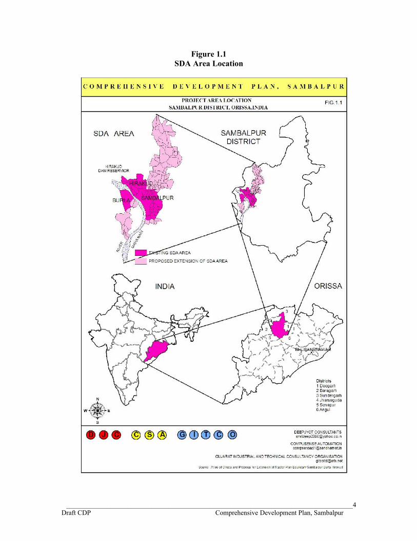
Figure 1.1SDA Area Location
____________________________________________________________________________________4Draft CDP Comprehensive Development Plan, Sambalpur

Sambalpur is a city in the western region of Orissa having the status of municipality and situated on the eastern bank of Mahanadi. It is the divisional head quarter of the northern administrative division of the State - also a very important Commercial and Educational center. Sambalpur lies at a distance of 321 km from the capital city of Bhubaneswar. It is the connecting city between Raipur on west and Bhubaneswar on east. Earlier it used to be known for its importance as a diamond trading centre. Nowadays it is mainly known for its textiles, folk dance and a variety of monuments.
Burla is a small town with a Notified Area Council (NAC) situated on the west bank of Mahanadi, and is about 20 kms from Sambalpur. The town lies at one end of Hirakud Dam which is located around 2 kms west of the town. The town's economy is mainly in retail, driven by the students, employees (their families) of the numerous educational institutions, local government employees (their families) and the incoming patient population for treatment at VSS Medical College. The town is also the headquarters of Mahanadi Coal Fields Ltd., a subsidiary of Coal India Ltd. The town is piquant and truly a university town and an education center of the district as it hosts the Sambalpur University, the VSS Medical College and the University College of Engineering (UCE Burla) , besides numerous schools and colleges.
Hirakud is also a small town with a Notified Area Council (NAC) in Sambalpur District. It is famous for the Hirakud Dam built over the Mahanadi River. Hirakud is also an Industrial township with number of industries particularly HINDALCO & JINDAL. Located 15 kms from the nearest city of Sambalpur, it is a town with a large portion of the population engaged in various industries located here.
1.5 Conceptualization of CDP
Sambalpur, Burla and Hirakud urban centers, along with their hinterlands, have grown over the time having separate identities and distinct growth potentials. Being contiguous and, to some extent, inter dependent to each other, growth prospects of the three urban centers deserve to be studied simultaneously and analyzed for exploring integrated development of the concerned urban region. For considering all physical and socioeconomic aspects of the urban region and exploring its meaningful role in balanced regional development preparation of Comprehensive Development Plan for Sambalpur, Burla & Hirakud Development Areas have become necessary. The Development Plan would guide the physical development and channelize harmonious growth of the urban centers, on exploring individual growth potentials of each of the urban centre. The regional setting of the SDA area with strong linkages and communication with the city of Bilaspur, Raipur, Cuttack-Bhubaneshwar-Puri, Rourkela-Howrah, Sundergarh etc. provides a vast potential for the development of Sambalpur-Burla-Hirakud area as commercial cum educational cum recreational cum small scale industrial hub.
____________________________________________________________________________________5Draft CDP Comprehensive Development Plan, Sambalpur

1.6 Inception Report
The Inception Report which was submitted in March 2009, outlined the scope of work, development issues, strategies, approach and methodology for preparation of the Comprehensive Development Plan (CDP) of the Sambalpur Development Authority (SDA). The intention was to discuss the framework of making the CDP at a meeting in with the officials of the SDA, the representatives of the local bodies within the SDA in Sambalpur and with key decision-makers, and on that basis to proceed for the preparation of the CDP for the SDA.
1.7 Scope of Work
The overall scope of work involves preparation of CDP for SDA, which includes mainly the following:
1) To generate the up-to-date urban land use map using GIS technology on 1:2000 scale and formulate Comprehensives Development Plan along with Land use Plan for proper utilization of land for residential, commercial, industrial, institutional, recreation, transportation, agricultural & allied usages in the region by 2030.
2) Traffic and transportation Plan with long and short term strategies to take up development phase wise.
3) Development control regulations and critical area guidelines for proposed and anticipated development pattern considering the holistic and integrated growth with specific emphasis on environment and natural hazard prone zone.
4) Review and propose institutional set up for the SDA.
1.8 Methodology
Methodology for formulation of CDP involved accomplishment of following identified six major actions (Table 1B):
Table 1BMajor Actions Accomplished
Action 1 Project Initiation • Understanding and conceptualization of project area• Mobilization of team
Action 2 Collection of existing information
A Preliminary Survey• Reconnaissance survey was undertaken to get
familiarized with the project area.• Preliminary investigation to figure out different
government departments and sources which could provide various information and data related to the project area.
B Assembling of Information and data
____________________________________________________________________________________6Draft CDP Comprehensive Development Plan, Sambalpur

• Collection of existing information to cover demographic, socio-economic, landuse, cultural, infrastructure, industrial and tourism aspects.
• Data on geographical profile was also collected which included natural features, geomorphology, soil condition and climate.
C Primary Survey• Undertaken Household survey, Slum survey, and various
traffic & transportation surveys to understand the need of the general public.
D Procurement of cadastral maps & satellite imageriesUp-to-date urban land use map using GIS technology on 1:2000 scale was generated on about 600 Revenue mouza sheets.
Action 3 Profile of the development area
A Preparation of Base map• To cover description of land use detail, aerial distribution
of forest & vegetation cover, land under agriculture use & settlement, waste land etc.
B Preparation of Thematic map• Main focus was on Topography, physiography, drainage,
road network, existing social amenities and demography.
Action 4 Analysis of the existing situation and conceptualizing the development plan
• Workshop to introduce CDP as conceived by project proponents was proposed. A cross-section of stakeholders / NGOs represented at the workshop to have overall visioning for the SDA area and to understand the need of the area in terms of physical and social infrastructure and land use.
A Analysis of socio-economic aspects• Demographic pattern in terms of population growth,
literacy rate, sex ratio and migration trend• Economic performance in terms of industries and
agriculture sector• Occupational structure, WFPR• Economic growth along the transport corridor• Urban Settlement pattern: twin city concept, single
nucleus to multi-nucleiB Analysis of Land use aspects• Land use distribution in the urban center• To determine direction & extent of spatial expansion of
urban centers, ecological sensitive zones, framing of zoning regulations & development control regulations
C Analysis of infrastructural aspects• Physical & social infrastructure gap was identified to
mitigate the existing lacunae.
Action 5 Development strategy • To formulate the plan incorporating the gaps and the need
____________________________________________________________________________________7Draft CDP Comprehensive Development Plan, Sambalpur

for the draft CDP of the area for integrated development.• To identify the growth centers, this could act as generator
of development in project area.• Proposals were formulated to provide for adequate
infrastructure in terms of proper connectivity and efficient public amenities.
Action 6 Institutional set up, project finance and implementation strategy completed
• An appropriate institutional mechanism has been identified.
• The proposals of the CDP have been converted into implementable projects and the financial arrangements have been worked out for the successful implementation.
• The General Development Control Regulations for controlling and promoting the development worked out.
• Training will be imparted to the staff / officers of the SDA for working on GIS.
The concept and methodology to formulate the CDP of the area is well explained in the Inception Report.
1.9 Significance of study area
Hub of Administrative – Socio-Cultural – Business -Education – Tourism PotentialSAMBALPUR
• Influence over surrounding villages
• NH, SH, Major roads provide linkages in 5 directions
• Pilgrimage and Site Seeing Spot, Leaning Temple of HUMA
• Badasadak and Sansadak from Kunjelpada chowk to Municipal Building has proud Heritage
• Industries
BURLA• University• Schools• Sports
Activities
HIRAKUD• Dam• Power
House• Reservoir• Industries
1.10 Past Planning Efforts
In the past, the towns of Sambalpur, Burla and Hirakud had three different Master Plans although these three towns are very close to each other and have a very strong interaction among themselves for the purpose of occupation, education, housing, services, trade & commerce, recreation, tourism, etc.
The Master Plan of Sambalpur comprising of Sambalpur Municipality and 21 adjoining villages admeasuring 96.75 sq kms was prepared by the Town Planning Unit Office of Sambalpur under the provisions of The Orissa Town Planning &
____________________________________________________________________________________8Draft CDP Comprehensive Development Plan, Sambalpur

Improvement Trust Act, 1956 and was sanctioned by the State Government on 10.11.1983.
Similarly, the Master Plan of Burla comprising of Burla NAC, part of Mahanadi River and 1 adjoining village of Amsadakatapali admeasuring 36.63 sq kms was prepared by the Town Planning Unit Office of Sambalpur under the provisions of The Orissa Town Planning & Improvement Trust Act, 1956 and was sanctioned by the State Government on 1.10.1986.
Hirakud town had originated as work colony when the Hirakud Dam Project was started in 1948. Due to the availability of electrical energy at the place of inception industries started comimg up in Hirakud. The Master Plan of Hirakud was prepared by the Town Planning Unit Office of Sambalpur under the provisions of The Orissa Town Planning & Improvement Trust Act, 1956 in 1965.
1.11 Existing Conditions and Regional Resource Potential
The Sambalpur-Burla-Hirakud complex under the jurisdiction of SDA is located at 21°30’ North latitude and 84°0’ East longitude on the western belt of Orissa at a distance of about 325 kms from Bhubaneshwar, the capital city. The SDA is responsible for planned development of this urban complex. The municipal town of Burla and Hirakud are continuous with Sambalpur Municipal area. The total urban agglomerate of Sambalpur-Burla-Hirakud complex had a combined population of 1,89,744 in 1991 which rose to 2,57,477 in 2001 as per census report with a decadal growth rate of 35.7 percent. The National Highway No.6, connecting Kolkatta to Mumbai passes through this cluster town.
Sambalpur District is the westernmost district in the state of Orissa, India. The historic city of Sambalpur is the district headquarters. Sambalpur is the third largest city in Orissa and one of the major commercial and industrial hubs in the western region of Orissa situated on the left bank of Mahanadi. It is the divisional head quarters of the Northern administrative division of the State - also a very important Commercial and Educational center. Sambalpur derives its name from that of the Goddess Samaleswari; an incarnation of Shakti, who is regarded as the reigning deity of the region. In History, it has been variously known as 'Sambalak', 'Hirakhanda', 'Dakhina Kosal'. Sambalpur city is the connecting city between Chhattisgarh and Orissa. It is situated at the latitude of 21°28’ N and longitude 83°58’ E and has a mean elevation of 148.1 mts to 156.3 mts above the sea
level. Whereas it used to be known for its importance as a diamond trading centre, nowadays it is mainly known for its textiles, folk dance and a variety of monuments. It's a good place from which to explore the surrounding forests and spot some of the rare species still roaming the area in one of the wild life sanctuaries, such as the well-known Badrama sanctuary.
Burla is a small town on the west bank of Mahanadi, and is about 20 kms from Sambalpur. Burla is located at 21.5° N 83.87° E. It has an average elevation of 173 metres. The town lies at one end of Hirakud Dam which is located around 2 kms west of the town. It acts as a premier institutional town of Orissa with more than 40
____________________________________________________________________________________9Draft CDP Comprehensive Development Plan, Sambalpur

years old Sambalpur University, 50 years old Medical College and 52 years old University College of Engineering besides office of Hirakud Dam Reservoir. Hirakud town is 5 kms north of Burla.
Formerly Hirakud was a small island lying between two branches of river Mahanadi. It is famous for the Hirakud Dam built over the Mahanadi River. It is a multipurpose project with the objective of flood control, irrigation, generation of electricity, navigation, soil conservation etc. Hirakud is located at 21.52° N 83.87° E. It has an undulating land with an average elevation of 160 metres. Elevation varies from 146 mts to 288 mts above sea level. Functionally Hirakud is an Industrial town with number of Industries particularly HINDALCO. Located 15 kms from the nearest city of Sambalpur, it is a quiet town with a large portion of the population engaged in various Industries located here.
1.12 Geography and Climate
The SDA area is situated in hot arid zone having extreme climate with the summer lasting from March to June. The monsoon is from July to October and the winter is from November through February.
The thick blanket of black cotton soil all over the district has been made somewhat sticky by the yellow earth developing in the undulating topography of the district. The general soil condition of the area is hard soil with hard granite stone beds visible on the soil surface at many places. The soil of the area is mostly characterized by red soil, but a small patch of mixed red soil and black soil appears in the southern part of Sambalpur town.
The SDA area is gifted with a natural drainage system from west to east. Keeping in view, the topography of the area, it can be divided into two major parts, namely, western upland and eastern lowland.
The Sambalpur district has a total forest area of 3986.27 Sq. Kms. which is 59.46% of the total area of the district. Total land under cultivation in the district is 173540 hectares.
1.13 Heritage Sites and Buildings
Sambalpur Complex serves as the gateway to the bewitching western zone of Orissa, abounding in lush green forests, colorful wild-life, exquisite array of hills, waterfalls of streaming pearls, rich tribal life and culture, folk songs and dances and a variety of monuments. Sambalpur has its own contribution to the cultural formation of our country.
Sambalpur retains its classic sleepy charm, even in the face of rapid, albeit unplanned expansion and a deluge of retail establishments. Some of the houses along the old part of Sambalpur are still maintained, and used, like they were, a century ago. A peculiar way the houses in the older parts of town are arranged is the gulli system, literally, mazeway. Houses in Patnaikpara, Nandpara, and along the parallel streets of Sansadak and Badsadak are examples of the above. The streets of Badasadak and
____________________________________________________________________________________10Draft CDP Comprehensive Development Plan, Sambalpur
Sansadak extending from Kunjelpada chowk to the office of the Sambalpur municipality, Samleshwari temple, Collector office, Municipal office, Budharaja Hill temple, Circuit house etc. have a proud heritage and have contributed immensely to make Sambalpur World famous and enriched the cultural heritage of the country.
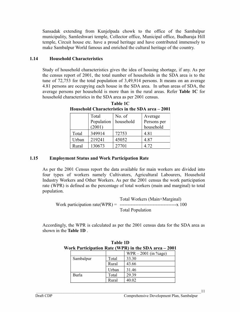
1.14 Household Characteristics
Study of household characteristics gives the idea of housing shortage, if any. As per the census report of 2001, the total number of households in the SDA area is to the tune of 72,753 for the total population of 3,49,914 persons. It means on an average 4.81 persons are occupying each house in the SDA area. In urban areas of SDA, the average persons per household is more than in the rural areas. Refer Table 1C for household characteristics in the SDA area as per 2001 census.
Table 1CHousehold Characteristics in the SDA area – 2001
1.15 Employment Status and Work Participation Rate
As per the 2001 Census report the data available for main workers are divided into four types of workers namely Cultivators, Agricultural Labourers, Household Industry Workers and Other Workers. As per the 2001 census the work participation rate (WPR) is defined as the percentage of total workers (main and marginal) to total population.
Work participation rate(WPR) =Total Workers (Main+Marginal)------------------------------------x 100Total Population
Accordingly, the WPR is calculated as per the 2001 census data for the SDA area as shown in the Table 1D .
Table 1DWork Participation Rate (WPR) in the SDA area – 2001
WPR – 2001 (in %age)Sambalpur Total 33.30
Rural 43.66Urban 31.46
Burla Total 29.39Rural 40.02
____________________________________________________________________________________11Draft CDP Comprehensive Development Plan, Sambalpur
Total Population (2001)
No. of household
Average Persons per household
Total 349914 72753 4.81Urban 219241 45052 4.87Rural 130673 27701 4.72

Urban 28.41Hirakud Total 34.33
Rural 48.30Urban 30.45
Additional Area of 67 Villages
Total 45.93Rural 45.93Urban 0.00
Total SDA Total 36.26Rural 45.42Urban 30.79
1.16 Housing Scenario
As per the census data for 2001, the Sambalpur municipality has total number of 43,235 census houses for 33,019 households. Out of 43,235 houses, 2,994 are vacant and therefore, 40,241 census houses are occupied in the Sambalpur municipality area as per 2001 census. Distribution of households by source of lighting, Distribution of households by availability of bathroom, latrine and drainage connectivity, availability of separate kitchen, type of fuel used for cooking within the house in Sambalpur, Burla and Hirakud Urban areas have been discussed in the Status Survey Report Part II.
1.17 Status Survey Reports
The status survey report of the SDA area was prepared and submitted in three Parts. The contents of the reports and the finding of surveys are briefly mentioned in the following paragraphs.
1.17.1 Status Survey Report PART-I
The contents of the Status survey Report Part-I is tabulated in the Table 1E below for reference.
____________________________________________________________________________________12Draft CDP Comprehensive Development Plan, Sambalpur

Table 1EContents of the Status Survey Report PART-I
1 Sambalpur Development Authority Existing scenario & jurisdiction of SDAStatutory provisionsObjectives of CDPSurveys identified
2 Policy Perspectives State Urban scenarioGovernment intervention
3 Prelude To Planning Efforts And Basis of Development
Earlier master plans of three towns are discussed
4 Regional Resource Potential And Heritage Conservation
Location & regional setting of 3 townsHistorical linkagesCultural LinkagesHeritage sites and buildingsTourism potential & supporting facilities
5 Demography Demographic profile of SDA as per 2001 censusSettlements distribution by population size and areal class
6 Economic Profile And Employment Landuse pattern as per Census 2001Employment Status-An overviewOccupational patternDraft Infrastructure policy of State Govt. for industrial developmentHousing Scenario-Number, use, facilitiesSlum Profile of 3 towns
7 Transportation, Communication, Services & Social Infrastructure
Sambalpur connected to major towns by NH-6, 42, SH-10 and major road in 5 directionsTruck terminus, Bus terminalsWater Supply, SWD, Sewerage & Sanitation system, Solid waste managementEducational facilities & Medical facilitiesCommunity facilities in Rural settlements
8 Environment Status And Natural Disturbances
Land formation, climate, soilPollutionSolid WasteGreenry, Flora, fauna & animal speciesPlantation, water bodies & artificial lakeCyclone, earthquake
9 Existing Development Control Regulations
Inadequacy identifiedRegulations proposed
10 Administration, Management and Finance
Existing scenario of SDANo CIP ( City Investment plan)No FOP (Financial Operation Plan)
____________________________________________________________________________________13Draft CDP Comprehensive Development Plan, Sambalpur

1.17.2 Status Survey Report PART-II
The contents of the Status survey Report Part-II is tabulated in the Table 1F below for reference.
Table 1FContents of the Status Survey Report PART-II
1 Household Survey• In Urban-rural areas• In Slum pockets
Local enumerators were engaged The survey was done in the early morning and in the late evenings when the head of the family is at home. Some information on the physical condition of the houses and the surroundings were collected by the enumerators.
Methodology - Random sample survey using Equal probability of Selection design (EPS) Well structured Questionnaire design.
Area Sample Size
%age of household
In urban-rural areas 1968 2.7%In slum pockets 501 2.5%
2 Traffic & Transportation Survey, Sambalpur
The traffic volume count survey at 8 intersections / locations were carried out on normal working days for the time interval between morning 9-00 a.m. to 1.00 p.m. and evening 3-00 p.m. to 7-00 p.m. for one day. Care in deciding the day of count was taken to avoid abnormal conditions of traffic like fair or exhibition.
Following two sections of the major road of the Sambalpur town was selected for the hourly count of number of different vehicles both mechanized and non-mechanised parked between 9am to 1.00pm and than from 4pm to 7pm irrespective of the duration of parking.
1. From Aithapali Bus stand to Court Chowk area
2. From Khetraj Petrol Pump to Dhanupali
It is important to collect the necessary data in connection with the traffic to be carried by the road system of the town. To assess the magnitude and nature of the problem and the extent of utilization of existing traffic facilities, the following surveys have been carried out.
• Traffic Volume survey• Street inventory• Parking Survey• Origin Destination Survey
8 intersections were selected for survey.
Location Name
Date & Day of Survey
1 Dhanupali Chowk
31.12.2009 Thursday
2 Laxmi Talkies Chowk
30.12.2009 Wednesday
3 Modipara Chowk
29.12.2009 Tuesday
4 Khetrajpur 01.01.2010 Friday5 Jharsugud
a Chowk02.01.2010 Saturday
6 Aithapali Chowk
04.01.2010 Monday
7 Remed Chowk
04.01.2010 Tuesday
8 P C Bridge Junction, Burla
06.01.2010 Wednesday
____________________________________________________________________________________14Draft CDP Comprehensive Development Plan, Sambalpur

Headings under which Household Survey data collected for urban – rural areas of the SDA and important findings are tabulated below in Table 1G.
Table 1GGist of Findings of Household Survey
Sr. No.
Item Finding
1 Year of stay Less in-migration.42% households living for more than 30 years
2 Family size 60% have 2-4 members3 Sex ratio 797 – very low4 Monthly family income One-third earning Rs.5000 – 10000 per
month5 Housing typology 80% have individual houses.
Horizontal growth of towns.6 Tenure status 76% Owners7 House condition 61% mostly in Sambalpur are living in
pucca houses.8 Built-up area 38% have 250-500 m2
35% have 500-1000 m2
4% have 2000 m2
9 Stand post distance 43% have not provided information46% have within premises or at a distance of less than 10m.
10 Summer source of water 46% have not provided information23% get from public stand post22% get from hand pumps
11 Water shortage perception Yes – 56%No - 30%No Comment – 14%
12 Water service perception Highly satisfied – 1%Satisfied – 31%Not Satisfied – 53%No Comment – 15%
13 Type of access to sanitation facility Septic tank – 74%Dry Latrine – 11%UGD – 0%
14 Sewerage and sanitation status Highly satisfied – 1%Satisfied – 60%Not Satisfied – 28%No Comment – 11%
15 Preferred sanitation connection Septic tank – 42%No Comment – 43%
16 Flooding effect Yes – 29%No - 71%
____________________________________________________________________________________15Draft CDP Comprehensive Development Plan, Sambalpur

17 Solid waste disposal mode Along the road – 55%Household collection – 7%
18 Solid waste disposal frequency Irregular – 73%Daily – 6%
19 Vehicle ownership 2 Wheeler – 46%Bicycle – 42%
20 Public transport service perception Good – 2%Satisfactory – 52%Poor – 30%
21 Regular use of public transport Yes – 11%No - 74%No Comment – 15%
22 Road type 59% have approach from Tar / Concrete road25% from earthen road16% from WBM road
23 Road width 57% from 3.5 to 7.5 m43% from less than 3.5 mts
24 Road surface perception Good – 23%Fair– 53%Poor – 24%
25 Type of street light Not available - 40%Tube light – 33Sodium Vapour Lamp – 27%
26 Presence of garbage on roads Yes – 71%No - 29%
27 Dustbin availability Yes – 8%No - 92%
28 Educational status Secondary Pass – 39%Graduate – 16%Illiterate – 12%
29 Occupational level Workers – 36% (mostly in Service & business)Non-workers – 64%
30 Expectation of service priorities
Sambalpur
Burla
Hirakud
Total SDA
area
Water Supply 1st 1st 5th 1stSewerage & Sanitation 4th 4th 4th 4th
Drainage 2nd 2nd 1st 2ndSolid Waste Disposal 3rd 3rd 3rd 3rd
Roads & Transport 5th 5th 2nd 5th
____________________________________________________________________________________16Draft CDP Comprehensive Development Plan, Sambalpur

Chart 1(a)
490
139
445
107178
163
289
371
334
156
182253
261
390
246
202
303
160
304
213
237
22385
135
492
240
307
192
244
229
1st 2nd 3rd 4th 5th Noresponse
EXPECTATION OF SERVICE PRIORITIES IN SDA AREA
Water Supply Sewerage & Sanitation Drainage Solid Waste Disposal Roads & Transport
Headings under which Slum Household Survey data collected and important findings are tabulated below in Table 1H.
Table 1HGist of Findings of Slum Household Survey
Sr. No.
Item Finding
1 Legal Title Status Yes – 44%No - 40%Information not provided – 16%
2 Specific Legal Title 40% - No legal right10% - free hold title
3 Willingness to improve Housing Condition
Yes – 38%No - 2%Information not provided – 60%
4 Sex ratio 821 – very low5 Family size 50% have 3-4 members
33% have 5-6 members6 Years of stay 67% more than 30 years7 Monthly family income 30% earning Rs.1500 – 2500 per month
30% earning Rs.2500 –5000 per month8 Tenure status 85% Owners9 House condition 64% mostly in Hirakud slums are living
in Kutcha houses.10 Built-up area 38% have 200-400 m2
____________________________________________________________________________________17Draft CDP Comprehensive Development Plan, Sambalpur

37% have 100-200 m2
13% have more than 400 m2
11 Source of Housing Finance 79% Self financing12 Summer source of water 35% have not provided information
20% get from public stand post30% get from hand pumps
13 Water service perception Highly satisfied – 0%Satisfied – 18%Not Satisfied – 72%No Comment – 10%
14 Type of access to sanitation facility Information not provided – 72%Dry Latrine – 16%LCS – 6%Public Conveniences- 5%
15 Sanitation Status Perception Highly satisfied – 0%Satisfied – 16%Not Satisfied – 79%No Comment – 5%
16 Preferred sanitation connection Individual -LCS – 42%No Comment – 72%
17 Flooding effect Yes – 35%No - 57%Information not provided – 8%
18 Solid Waste Disposal Mode Along the road – 66%Identified place – 21%
19 Distance of Solid Waste Disposal Information not provided – 49%Less than 25 mts – 36%
20 Solid waste disposal frequency Irregular – 66%Daily – 12%
21 Solid Waste Disposal Mode Perception
Highly satisfied – 0%Satisfied – 17%Not Satisfied – 76%
22 Paved Road in front of House Yes – 61%No - 30%Information not provided –9%
23 Status of Street Light Present - 70%Absent - 24%Information not provided –6%
24 Vehicle ownership Bicycle – 76%2 Wheeler – 9%
25 Public transport service perception Good – 5%Satisfactory – 55%Poor – 31%
26 Regular use of public transport Yes – 14%No - 58%No Comment – 28%
____________________________________________________________________________________18Draft CDP Comprehensive Development Plan, Sambalpur

27 Location of Slums Along the main road – 66%Along the Nalla – 24%Along the railways – 7%Hill slopes – 3%
28 Road type 60% have approach from Tar / Concrete road33% from earthen road7% from WBM road
29 Road width 51% from less than 3.5 mts 43% from 3.5 to 7.5 m
30 Road surface perception Good – 20%Fair– 44%Poor – 36%
31 Presence of road side drains Not present – 51%Single side – 37%Both side – 12%
32 Presence of garbage in the neighborhood
Yes – 76%No - 24%
33 Predominant neighborhood Residential – 90%Commercial – 6%Industrial – 4%
34 Educational status Illiterate – 34%Primary Pass – 31%Secondary Pass – 29%Graduate – 4%
35 Occupational level Workers – 44% (mostly daily wagers)Non-workers – 56%
36 Expectation of service priorities
Sam
balp
ur
Bur
la
Hira
kud
Tota
l SD
A
area
Water Supply 1st 1st 1st 1stSewerage & Sanitation 3rd 4th 2nd 3rd
Drainage 2nd 3rd 3rd 2ndSolid Waste Disposal 4th 5th 4th 4th
Roads & Transport 5th 2nd 5th 5th
____________________________________________________________________________________19Draft CDP Comprehensive Development Plan, Sambalpur

Chart 1(b)
226
96
551428
66
103
115
4875
46
100
131
8642
4980
67
140
59
252433
114
190
89
98
100
99
107
1st 2nd 3rd 4th 5th Noresponse
EXPECTATION OF SERVICE PRIORITIES IN SLUMS OF SDA AREA
Water Supply Sewerage & Sanitation Drainage Solid Waste Disposal Roads & Transport
Inference from Traffic and Transportation Survey
Traffic conditions are nothing short of chaos especially on roads around the Khetrajpur (railway station), Golebazar, Laxmi Talkies chowk, and Remed Chowk to Jharsuguda chowk. Existing roads are also extensively used for on-street parking. Due to excessive demand from the entire town as well as from the SDA area, the central area of Sambalpur town has been inefficient to function as a town – centre for the whole City. Traffic congestion is now order of the day. It is important to collect the necessary data in connection with the traffic to be carried by the road system of the town. To assess the magnitude and nature of the problem and the extent of utilization of existing traffic facilities, the following surveys have been carried out.
1. Traffic Volume survey
2. Street inventory
3. Parking Survey
The total volume count of the traffic both mechanised and non-mechanised in the morning and evening peak hour at each of the 8 intersections of the SDA area are depicted in the Chart 1(c) below. It is observed that the daily peak hour is observed in the morning itself at all the intersections except at Modipara Chowk where the peak hour is observed during the evening hour. At Dhanupali Chowk the morning and evening peak has almost the same value of PCU.
____________________________________________________________________________________20Draft CDP Comprehensive Development Plan, Sambalpur

Chart 1(c)
Morning - Evening PEAK HOUR EQUIVALENT PCU AT 8 JUNCTIONS IN SDA AREA
2106
3211
17911471
2995
4604
1780
2550
2163
2992
2251
943
2844
4436
1495
2403
DhanupaliChowk
LaxmiTalkiesChowk
ModiparaChowk
KhetrajpurJunction
JharsugudaChowk
AithapaliChowk
RemedChowk
P C Bridge,Burla
PE
AK
HO
UR
PC
U
Morning Evening
The peak hour demand of parking space in terms of Equivalent Car Space i.e. ECS at different parking location both designated and not-designated, surveyed from Anthiapali Bus Stand to Court Chowk Area and Khetraj Petrol Pump to Dhanupali area are depicted respectively in Chart 1(d) and Chart 1(e) on the following pages.
Chart 1(d)
____________________________________________________________________________________21Draft CDP Comprehensive Development Plan, Sambalpur
Peak Hour Parking Demand in ECS from Aithapali Bus stand to Court Chowk Area
132
91
16 13
55
2131
20 25 31
71
0
20
40
60
80
100
120
140
Aithapali Bus-stand
AithapaliChow k
AN Guha LineChow k
Petrol Pum p(Laxm i
Talkies )
Gola BazarChow k [1]
Gola BazarChow k [2]
Court Chow kArea [1]
Court Chow kArea [2]
Tow n Thana[Parking Area]
Court Area [1] Court Area [2]
Not-Des ignated Designated
PEAK
HOU
R EC
S
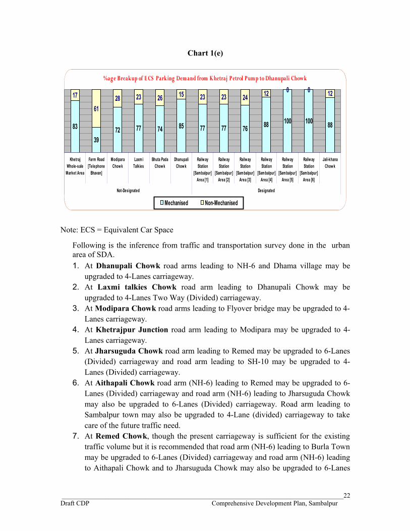
Chart 1(e)
Note: ECS = Equivalent Car Space
Following is the inference from traffic and transportation survey done in the urban area of SDA.1. At Dhanupali Chowk road arms leading to NH-6 and Dhama village may be
upgraded to 4-Lanes carriageway.2. At Laxmi talkies Chowk road arm leading to Dhanupali Chowk may be
upgraded to 4-Lanes Two Way (Divided) carriageway.3. At Modipara Chowk road arms leading to Flyover bridge may be upgraded to 4-
Lanes carriageway.4. At Khetrajpur Junction road arm leading to Modipara may be upgraded to 4-
Lanes carriageway.5. At Jharsuguda Chowk road arm leading to Remed may be upgraded to 6-Lanes
(Divided) carriageway and road arm leading to SH-10 may be upgraded to 4-Lanes (Divided) carriageway.
6. At Aithapali Chowk road arm (NH-6) leading to Remed may be upgraded to 6-Lanes (Divided) carriageway and road arm (NH-6) leading to Jharsuguda Chowk may also be upgraded to 6-Lanes (Divided) carriageway. Road arm leading to Sambalpur town may also be upgraded to 4-Lane (divided) carriageway to take care of the future traffic need.
7. At Remed Chowk, though the present carriageway is sufficient for the existing traffic volume but it is recommended that road arm (NH-6) leading to Burla Town may be upgraded to 6-Lanes (Divided) carriageway and road arm (NH-6) leading to Aithapali Chowk and to Jharsuguda Chowk may also be upgraded to 6-Lanes
____________________________________________________________________________________22Draft CDP Comprehensive Development Plan, Sambalpur
%age Breakup of E CS Parking Demand from K hetraj Petrol Pump to Dhanupali Chowk
83
3972 77 74 85 77 77 76 88 100 100 88
17
6128 23 26 15 23 23 24 12 0 0 12
KhetrajWhole-sale
Market Area
Farm Road[Telephone
Bhavan]
ModiparaChow k
Laxm iTalkies
Bhuta PadaChow k
DhanupaliChow k
Railw ayStation
[Sambalpur]Area [1]
Railw ayStation
[Sam balpur]Area [2]
Railw ayStation
[Sam balpur]Area [3]
Railw ayStation
[Sam balpur]Area [4]
Railw ayStation
[Sam balpur]Area [5]
Railw ayStation
[Sam balpur]Area [6]
Jail-khanaChow k
Not-Designated Designated
Mechanised Non-Mechanised

(Divided) carriageway so as to have a contiguous road width along the NH-6 in the SDA area to take care of the future traffic need.
8. At PC Bridge Junction in Burla, road arm (NH-6) leading to Baragarh and to Raipur and beyond may be upgraded to 6-Lanes (Divided) carriageway and road arm (NH-6) leading to Sambalpur Town via Aithapali Chowk and to Jharsuguda Chowk may also be upgraded to 6-Lanes (Divided) carriageway so as to have a contiguous road width along the NH-6 in the SDA area to take care of the future traffic need.
9. Gole bazar area and Court Chowk area does not have parking requirement for slow moving vehicles like cycle and cycle rickshaws. A N Guha Chowk popularly known as Laxmi Narayan Mishra Chowk has the high requirement of parking space for the slow moving vehicles (non-mechanised).
10.Dhanupali chowk area and the Khetraj Petrol Pump area have the heavy requirement of parking space for the fast moving vehicles. At Farm road near telephone exchange, cycle rickshaws were found to be parked haphazardly on the road capturing parking space equivalent to almost 8 cars. More than 60 percent vehicles parked were slow moving vehicles.
1.17.3 Status Survey Report PART-III
The contents of the Status survey Report Part-III is tabulated in the Table 1I below for reference.
Table 1IContents of the Status Survey Report PART-III
1 Digital Basemap Creation And Landuse Mapping
Digitization & geo-referencing 1. Digitization of Cadastral map2. Digitization of Mauza3. Mosaicing of mauza sheets4. Georeferencing of mauza map5. Preparation of cadastral mosaic
Image InterpretationGround Truth Data CollectionGIS Database Creation
2 Present Urban Structure – Existing Landuse
The GIS database is developed in ArcGIS platform. The soft copy of the base map in the scale of 1 : 2000 prepared by interpreting the satellite imageries has already been provided to the SDA.
Spatial Extent of Zones ExplainedMaster plan of Sambalpur : X ZonesMaster plan of Burla : III ZonesMaster plan of Hirakud : III ZonesProposed 67 Villages : VII Zones
____________________________________________________________________________________23Draft CDP Comprehensive Development Plan, Sambalpur

1.18 GIS Database
The digital base map of study area is created using satellite imageries and superimposing with the revenue maps for Comprehensive development plan.. Rectification and geo referencing of the satellite imagery was done using DGPS control survey. The revenue sheets are properly edge matched to form revenue villages and mosaics of villages are made to form the Development Plan Area. A grid base is generated for the CDP area to produce the hard copy maps in standard A1 size in 1: 2000 scale.
The GIS database is developed in ArcGIS platform. The soft copy of the base map in the scale of 1: 2000 prepared by interpreting the satellite imageries has already been provided to the SDA.
A Digital Basemap Creation and landuse Mapping
The preparation of comprehensive Development Plan starts with the assessment of the existing conditions & accounting for the potential resources and constrains. As a part of assessment of physical characteristics and natural resources, the exercise of mapping existing landuse translated over digital revenue plan as per interpretation of satellite imagery and field verification was carried out. Methodology of digitization, geo-referencing of cadastral database and landuse mapping was made available by Orissa Remote Sensing Applications Centre (ORSAC) vide ORISSA Technical Manual 2009 on cadastral level urban LIS for urban planning. GIS data base standards were taken from NUIS design and standards of TCPO, Govt. of India, MOUD.
B Digitization and Geo referencing of Cadastral Maps
The purpose of digitization and geo referencing of cadastral maps is to generate digital data sets in cadastral scales so as to make it usable by various agencies at ground level for various development plan preparation activities. Therefore, the methods of scanning, vectorization and geo referencing were standardized by ORSAC. These methods were followed throughout the project.
Cadastral maps in paper format are available at different scales such as 16’:1 mile, 32’:1 mile and 64’:1 mile which is approximately 1: 4000, 1: 2000 and 1: 1000 respectively in MKS System. There may or may not be any projection system in village maps. The overall flow of activities is shown in Figure 1.2.
____________________________________________________________________________________24Draft CDP Comprehensive Development Plan, Sambalpur
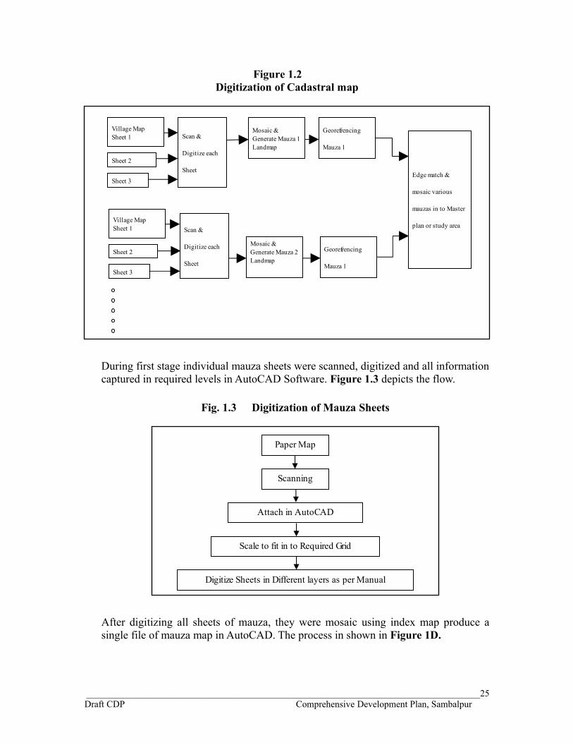
Figure 1.2 Digitization of Cadastral map
During first stage individual mauza sheets were scanned, digitized and all information captured in required levels in AutoCAD Software. Figure 1.3 depicts the flow.
Fig. 1.3 Digitization of Mauza Sheets
After digitizing all sheets of mauza, they were mosaic using index map produce a single file of mauza map in AutoCAD. The process in shown in Figure 1D.
____________________________________________________________________________________25Draft CDP Comprehensive Development Plan, Sambalpur
Paper Map
Scanning
Attach in AutoCAD
Scale to fit in to Required Grid
Digitize Sheets in Different layers as per Manual
Village Map Sheet 1 Scan &
Digitize each
Sheet
Mosaic & Generate Mauza 1 Landmap
Georefrencing
Mauza 1
Sheet 2
Sheet 3Edge match &
mosaic various
mauzas in to Master
plan or study area
Georefrencing
Mauza 1
Mosaic & Generate Mauza 2 Landmap
Village Map Sheet 1
Sheet 2
Sheet 3
Scan &
Digitize each
Sheet

Fig.1.4 Mosaicing of mauza sheets
Each mauza map in digital format was then exported from AutoCAD to GIS environment using ArcGIS software, where it can be overlaid on a satellite image. Using technique of spatial adjustment the mauza maps were overlaid on satellite image with reference to features seen in the satellite images and those depicted in mauza maps. There is shown in Fig. 1.5.
Fig. 1.5 Geo referencing of mauza map
Individual geo referenced mauza maps were then edge matching by putting them side by side and referring to satellite images to match the mauza boundaries, which are in many cases natural boundaries or roads etc. thus a seem less map of each region like master plan area, municipal area were created. They can be further mosaic in to bigger mosaic covering entire study area (Fig. 1.6).
Fig. 1.6 Preparation of cadastral mosaic
____________________________________________________________________________________26Draft CDP Comprehensive Development Plan, Sambalpur
Digitized Sheets
Mosaic all Sheets of one Mauza
Export Layers to .shp file in ArcGIS with all codes
Open Image in GIS
Open .shp file of Village Mosaic
Carry out Spatial Adjustment
Generate Geo refrenced Village map
Individual Village Map
Add Other Village Maps
Carry Out Edge Matching
All Edge Matched Map to Create Mosaic

C Image Interpretation
Image interpretation was done using above referred classification system and visual technique of remote sensing involving parameters such as tone, texture, shape, size, shadow, pattern location or association and field knowledge. Sequence of image interpretation is shown in Figure 1.7.
Fig. 1.7 Image Interpretation
D Ground Truth Data Collection
Ground truth in remote sensing projects is the process of verifying the classification done on basis of interpretation techniques applied. It is to be carried out on sample basis to come all possible classes and to ascertain the doubtful signatures which cannot be resolved without field knowledge. In this project the local field knowledge was available and in addition ground truth was collected to verify the classification.
E GIS Database Creation
GIS database has been created as per guidelines from Orissa Remote Sensing Applications Centre, Bhubaneshwar.
1.19 Broad Existing Landuse of SDA Area
The details of the broad landuse of the developed land in the SDA area with 67 villages is shown in the Table 1J and broad existing landuse is depicted in the Chart 1(j) below. The figures are obtained by adding the numerical data of the respective use zones of the master plan areas of Sambalpur, Burla and Hirakud and that of the proposed 67 villages. The table is generated to understand the overall existing land use of the SDA area if the proposed 67 villages are considered to be included in its jurisdiction. This will help in framing the proposals of landuse for the CDP of SDA in case these 67 villages are included in its boundaries. Otherwise also it is important to understand the existing landuse in the regional context.
45 percent of the developed land mostly in the rural area is presently put to residential use in the SDA area with 67 villages. More than 25 percent of the developed land of the SDA area combined with 67 villages is being used for the residential purposes in the rural areas. Circulation and transport occupies almost 35 percent of the developed land. Most of the land in this category is under roads, parking, terminus for buses and trucks, etc. Railways occupy less than 2 percent (1.75%) of the developed land in this category. Less than 2 percent of the developed land is used for the commercial purposes in the overall SDA area with 67 villages. Industrial use of the developed land is significant. Overall in the present SDA area with 67 villages, more than 12 percent of the developed land is being used for the industrial purpose. Another 4 percent of the developed land is put to use for public and semi-public purposes
____________________________________________________________________________________27Draft CDP Comprehensive Development Plan, Sambalpur
ImageVisual
Identification
Delineation by fixing
boundaries Categorization Identification

mainly for the administrative buildings. Only 1.12 percent of the developed land in the present SDA area with 67 villages are put to educational and health service uses. Less than 1 percent (only 0.60%) of the developed land is used for the utility and services in the present SDA area with 67 villages. Open spaces and recreation in the present
SDA area also occupies less than 1 percent of the developed land. Road network occupies most of the developed land (34.08%) in the present SDA area with 67 villages. The development potentialities of the SDA area with the proposed 67 villages because of the presence of large network of roads (national highways, state highway and major roads) can be exploited while framing the proposals for the proposed landuse of the SDA in the CDP if the proposed 67 villages are included in the SDA area.
Table 1J BROAD EXISTING URBAN LANDUSE CLASSIFICATION OF DEVELOPED
LAND – SDA Area, 2010Sr. No. Use Zone
Area(in Hectares) % age
1 Residentiali Urban 825.69 19.75
ii Rural 1080.62 25.85iii Total 1906.31 45.60
2 Commercial 66.80 1.593 Industrial 509.40 12.184 Public & semi-public
i Administrative 96.26 2.30ii Religious 5.14 0.12
iii Education & Health 46.90 1.12iv Cultural 2.59 0.06v Total 150.89 3.60
5 Utility & services 25.40 0.60
6Open Space & Recreation
i Park 9.66 0.23ii Play Ground 12.94 0.31
iiiOpen Space / Recreation & Sports area 0.63 0.01
iv Total 23.23 0.557 Circulation / Transport
i Road, Parking, Bus/Truck terminus 1424.66 34.08
ii Railway 73.32 1.75iii Total 1497.98 35.83
Total Developed Land 4180.01 100
____________________________________________________________________________________28Draft CDP Comprehensive Development Plan, Sambalpur
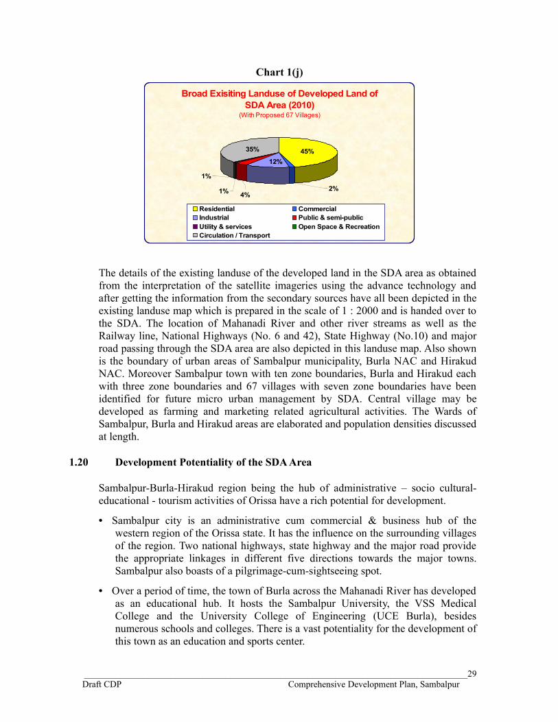
Chart 1(j)
Broad Exisiting Landuse of Developed Land of SDA Area (2010)
(With Proposed 67 Villages)
45%35%
12%
2%
1%
1% 4%
Residential CommercialIndustrial Public & semi-publicUtility & services Open Space & RecreationCirculation / Transport
The details of the existing landuse of the developed land in the SDA area as obtained from the interpretation of the satellite imageries using the advance technology and after getting the information from the secondary sources have all been depicted in the existing landuse map which is prepared in the scale of 1 : 2000 and is handed over to the SDA. The location of Mahanadi River and other river streams as well as the Railway line, National Highways (No. 6 and 42), State Highway (No.10) and major road passing through the SDA area are also depicted in this landuse map. Also shown is the boundary of urban areas of Sambalpur municipality, Burla NAC and Hirakud NAC. Moreover Sambalpur town with ten zone boundaries, Burla and Hirakud each with three zone boundaries and 67 villages with seven zone boundaries have been identified for future micro urban management by SDA. Central village may be developed as farming and marketing related agricultural activities. The Wards of Sambalpur, Burla and Hirakud areas are elaborated and population densities discussed at length.
1.20 Development Potentiality of the SDA Area
Sambalpur-Burla-Hirakud region being the hub of administrative – socio cultural-educational - tourism activities of Orissa have a rich potential for development.
• Sambalpur city is an administrative cum commercial & business hub of the western region of the Orissa state. It has the influence on the surrounding villages of the region. Two national highways, state highway and the major road provide the appropriate linkages in different five directions towards the major towns. Sambalpur also boasts of a pilgrimage-cum-sightseeing spot.
• Over a period of time, the town of Burla across the Mahanadi River has developed as an educational hub. It hosts the Sambalpur University, the VSS Medical College and the University College of Engineering (UCE Burla), besides numerous schools and colleges. There is a vast potentiality for the development of this town as an education and sports center.
____________________________________________________________________________________29Draft CDP Comprehensive Development Plan, Sambalpur

• Similarly, Hirakud town is an industrial town famous for the Hirakud Dam and the HINDALCO factory. Due to the operation of the multi-purpose Hirakud Dam Project the importance of Sambalpur increased manifold. This town has a vast untapped potential for the development of water resources and tourism. This can be developed as a center for water management, irrigation, power generation, recreational areas, tourism etc.
• The streets of Badasadak and Sansadak extending from Kunjelpada chowk to the office of the Sambalpur municipality have a proud heritage.
• The regional setting provides the potentiality for further development of the town. Sambalpur railway station, situated 3 km from the city center, has direct connections to Bilaspur, Jhansi, Kolkata, Bhubaneswar, New Delhi and Chennai. It is an important junction on Raipur-Puri broad-gauge railway track.
• The nearby Airports are at Bhubaneswar (325 km) and Raipur (300 km). Regular bus services connect the town with Bhubaneswar, Cuttack and Puri.
• Jharsuguda which is a cosmopolitan town and is fast emerging as the economic hub of western Orissa is only 70 km from Sambalpur and is well connected with railway and major road. Many small and medium scale steel units are being set up in the Jharsuguda town vicinity giving impetus to the industrial growth of the district. This Sambalpur – Jharsuguda corridor is well accessible and connected to other parts of the state and other neighboring states as well to facilitate the flow of commodity, goods and services to the required destination.
• The regional setting of Sambalpur and Jharsuguda provides a perfect setting for the development of this corridor on the basis of twin city concept.
• Sambalpur town has developed in a unplanned manner. Its existing infrastructure status does not provide amenities for modern living. Recent rapid industrialization in Sambalpur- Jharsuguda area creates a clear impression that both the towns will develop into a twin city and civil life of this area will become very hectic due to congestion and pollution and in absence of any proper planning, township will develop in very haphazard manner by the side of S.H. 10. Because of the absence of proper infrastructure, educational institutions and corporate houses may not come to Sambalpur for establishing their institutions. A well planned strategically located SATELLITE TOWNSHIP in the Sambalpur Development Authority area in the vicinity of the Sambalpur – Jharsuguda corridor has a potential to develop which is proposed in the CDP.
With such background and potentialities for development, this SDA area stands at a major crossroad. At present the central area of Sambalpur is the only developed area in the SDA having not much integration with the towns of Burla and Hirakud. Separate master plans were prepared for Sambalpur, Burla NAC and Hirakud NAC. The CDP will thus be an attempt to analyze such vital issues and frame realistic guidelines and action plans for achieving a balanced and planned development.
____________________________________________________________________________________30Draft CDP Comprehensive Development Plan, Sambalpur

1.21 Planning Issues
Physical environment is a dynamic, complex and interconnected system. Planning for harmonious development recognizes unity between man and nature. Planning for recreational area is important aspect of the urban planning. Recreational areas such as public parks, gardens, green open spaces, river banks etc. and recreational activities such as sports, trekking, mountaineering, hunting, skiing, swimming etc. perform not only the hygienic function of lungs, but they form, in view of the present state of technical advance, an oasis of leisure, mental peace filling stations for the whole population.
For passive recreation, recreational park such as national and regional parks, wild life safari parks, orchards etc. are a great source of inspiration and relief. Besides this, areas having beautiful natural landscape can be more refreshing and inviting with little efforts to make them approachable without disturbing their character. All these recreational areas evoke in the observer a strong and distinctive emotional response. Hirakud Dam site and its surrounding area with number of water ponds amidst dense hilly forest will create unique natural environment. There is a potential for Tourist Complex which can include cultural centre, spiritual center, environmental education center, holiday resort, hotels. Amusement parks with water rides, boating club, and fountain with light and music at garden on the line Vrindavan garden of Mysore can be developed. With indoor – outdoor games, a state level sport stadium can be developed. Thick dense wood logs with jungle track, bird watching towers, forest huts, safari park, etc. can be developed in the forest area. Eco-tourism is conceptually a purposeful travel to natural areas with an emphasis to understand the culture and natural history of environment, taking care not to alter the integrity of the Eco-system, which providing economic opportunities that make the conservation of natural resources beneficial to the inhabitants of the host region. Botanical garden can become point of attraction. Agro-Medicine (Ayurvedic) Research and Development centre can be developed here. Exhibition centre for displaying tribal arts and crafts, melaground, aquarium etc. can also be developed. All these activities require considerable area which can be developed within the land available in the SDA area.
1.21.1 At a regional level
The regional setting of the SDA area with a strong linkages and communication with the city of Bilaspur, Raipur, Cuttack-Bhubaneshwar-Puri, Rourkela-Howrah, Sundergarh provides a vast potential for the development of Sambalpur-Burla-Hirakud area as commercial cum educational cum recreational cum small scale industrial hub making use of linkages with the neighboring large cities of Raipur, Bilaspur and Rourkela and supporting the smaller towns of the Orissa state. At a regional level the development projects have been proposed considering the Sambalpur – Jharsuguda as a twin city there being very close socio-economic relationship between these two towns. Both the towns are about 70 kms apart and are connected with railway and major road. Jharsuguda is a cosmopolitan town and is fast emerging as the economic hub of western Orissa. Currently, many small and medium scale steel units are being set up in the town vicinity giving impetus to the industrial
____________________________________________________________________________________31Draft CDP Comprehensive Development Plan, Sambalpur

growth of the district. Jharsuguda is an Industrial town as well as a Business center catering to the daily basic needs of nearby areas. This corridor is well accessible and connected to other parts of the state and other states as well to facilitate the flow of commodity, goods and services to the required destination. Hirakud dam reservoir is located on north of Sambalpur urban settlement and stretches on west, along major length of rail and road connections between Sambalpur and Jharsuguda. Huge reserve forest adjacent to the SDA area shall provide input for the agro based industries which can be linked to the markets of major urban centers of Raipur, Bilaspur and Rourkela. As such, the possibility of developing rural areas as Mandi center, socio-economic node, water resort and agro-industrial based nodes have been worked out.
1.21.2 At the city level
At the city level the CDP is conceptualized to transform the area within the SDA from single nucleus (core area of Sambalpur) to multi nuclei i.e.
Sambalpur as Administrative and Business hubBurla as Education and Sports CenterHirakud as Tourism and Recreational area67 Villages Prosperous agricultural activity
area
Following proposals need consideration.
Upgradation of roads having regional linkages. Upgradation of Urban and rural links. Various zones for modern recreation facilities and theme parks for outdoor
recreation. Development of Commercial nodes Major organized open spaces like, urban squares, ceremonial / recreational
grounds. Health complex, educational complex Development of Hirakud reservoir for the state level recreational use. Development of forest based activity node. New Satellite Township. Flyovers and Parking Lots Preservation & Development of Water. Bodies and Water Retaining Structures
All these activities will be integrated in the planned and coordinated manner to have multi nuclei in the SDA area instead of single nucleus in the Sambalpur city.
____________________________________________________________________________________32Draft CDP Comprehensive Development Plan, Sambalpur

1.21.3 Satellite Township
Sambalpur Town has developed in unplanned manner. Its existing infrastructure status does not provide amenities for modern living. Recent rapid industrialization in Sambalpur- Jharsuguda area creates a clear impression that both the towns will develop into a twin city and civil life of this area will become very hectic due to congestion and pollution and in absence of any proper planning, township will develop in very haphazard manner by the side of S.H. 10. Because of the absence of proper infrastructure, educational institutions and corporate houses may not be coming to Sambalpur for establishing their institutions. It is understood that the SDA has conceived to develop a well planned SATELLITE TOWNSHIP in a strategically located area between Sambalpur Town and Jharsuguda over an area of about 2000 acre of land to cater to the need of people and the institution. As a part of the CDP, the location of this Satellite Township is proposed
To realize the stated objectives a detailed methodology has been worked. For the purpose of preparation of development plan a detailed and extensive study has been done. An exhaustive review of literature on regional planning documented for various similar regions was also undertaken. The primary data has been collected from various discussions with persons involved in the development work followed by interactions with the local people and stakeholders. It was supplemented with reconnaissance survey and numerous visits to the site. However, the plan proposals substantially utilized secondary and recorded data collected from various sources and relied on the Census 1991 and census 2001 data. Analysis of development potential of the development area was undertaken so as to evolve the development plan proposals.
Development of this region, if efficiently and equitably managed, will trigger development of its adjoining hinterland, which in turn would help raise the level of overall welfare in this part of the region.
1.22 Slum Profile
As per the Census of India the slum is defined as “A compact area of at least 200 populations or about 60-70 households of poorly built congested tenements, in unhygienic environment usually with inadequate infrastructure and lacking in proper sanitary and drinking water facilities.”
Slum population data is still not available for the last census 2011. In the Census 2001 report, slums are notified only in the Sambalpur Municipality area. The profile of slums both notified and non-notified in the SDA area has been discussed in the following paragraphs based on the census 2001 data and the information available from the Sambalpur municipality, Burla NAC and Hirakud NAC.
a. Slums in Sambalpur Municipality
As per the 2001 census report, the slum population in the Sambalpur municipality is 30,726 persons occupying different locations in the 29 wards of the municipality. The total population of the Sambalpur municipality as per the 2001 census was 153643. It means 20% of the municipality population was living in the slums in 2001. Out of
____________________________________________________________________________________33Draft CDP Comprehensive Development Plan, Sambalpur

31,502 households in the Sambalpur municipality, 6441 households (i.e. 21 %) were in the notified slum pockets. The wardwise slum population in Sambalpur municipality as per census report of 2001 is shown in the Table 1K below.
Table 1KSlum Population in Sambalpur Municipality – 2001
Slum %age to Total Slum PopulationHousehold Population
Ward No. 1 124 691 2.25Ward No. 2 133 576 1.87Ward No. 3 356 2025 6.59Ward No. 4 0 0 0Ward No. 5 146 702 2.28Ward No. 6 201 1117 3.64Ward No. 7 123 582 1.89Ward No. 8 144 580 1.89Ward No. 9 289 1341 4.36Ward No. 10 0 0 0Ward No. 11 0 0 0Ward No. 12 133 761 2.48Ward No. 13 0 0 0Ward No. 14 0 0 0Ward No. 15 230 1159 3.77Ward No. 16 262 1240 4.04Ward No. 17 126 581 1.89Ward No. 18 180 749 2.44Ward No. 19 370 1726 5.62Ward No. 20 237 1179 3.84Ward No. 21 458 2156 7.02Ward No. 22 127 617 2.01Ward No. 23 114 676 2.20Ward No. 24 729 3154 10.26Ward No. 25 471 2202 7.17Ward No. 26 634 2822 9.18Ward No. 27 627 3030 9.86Ward No. 28 227 1060 3.45Ward No. 29 0 0 0Sambalpur Municipality 6441 30726 100
(Census 2001 report)
Slums are not evenly spread across wards. Out of total of 6441 slum household in Sambalpur municipality highest number of slum households 729 is reported in Ward No. 24. Almost one-third of the slum population is living in three wards (no. 24, 26
____________________________________________________________________________________34Draft CDP Comprehensive Development Plan, Sambalpur

and 27) of the Sambalpur municipality. As per the census 2001 report, ward no. 4, 10, 11, 13, 14 and 29 does not have any slums. The number of persons per household comes out to be 4.77 as per this census report.
As per the information available from the survey done in 2011 by the City Level Technical Cell under Rajiv Awas Yojna (RAY) of the Sambalpur municipality for Slum Free City Plan of Action, there were 104 slum pockets in Sambalpur municipality in 2011 which includes both notified (as per census) and non-notified slums having total population of 72,945 persons. Sambalpur municipality has identified any area unfit for human habitation by reasons of dilapidation, overcrowding, faulty arrangement and design of buildings, narrow streets and lack of sanitary facilities which are not included in the census slums as non-notified slums.
The details of name of the slum pocket both notified and non-notified in each ward as per the survey done in 2011 by the Sambalpur municipality are shown in the Table 1L below.
Table 1L Ward wise Slum Details in Sambalpur Municipality – 2011
Ward No.
Pocket No.
Name of the Slum Pocket Slum PopulationPocketwise Total ward
1
1 Betrapara, 1165
4444
2 Vatra-1, 1140
3 Vatra-2 937
4 Dhanupali, 657
5 Turi Para 545
2
6 Govindtola 381
20457 Bhuta Para 550
8 Charvati 1114
3
9 Motijharan 1268 204810 Suna Pali 780
4
11 Nagenchoti 982 139212 Rashtrapati Chowk 410
5 13 Mayabagicha 1214 1214
6
14 Pension Para 1422 223215 Kawbadi Para - Dalei Para 810
7 16 Saliabagicha (Danibandh) 1439
____________________________________________________________________________________35Draft CDP Comprehensive Development Plan, Sambalpur

211417 Danibandh 675
8
18 Sahid Para 627
292019 Dhuchur Para 1242
20 Ganeshwar Berna 1051
9
21 Ekodo Para 977
5064
22 Salchi Para 873
23 Samali Para 1210
24 Sarlakani 1211
25 Sarlakani - Gandhi Colony 410
26 Berna 383
10
27 Jhankar Para (near City Rly Stn) 172 39528 Keut Para-1 223
11 xxxxxxxxxxx 0 0
12 29 Dhula Para 234 234
13 30 Pattnaik Para 563 563
14
31 Telna Para 581 133832 Mali Bagicha 757
15
33 Kamli Bazar 412
276334 Theko Para 1330
35 Sahu Colony 1021
16
36 Ambedkar Nagar 1610 216537 Bohidhar Bandh 555
17
38 LIC 474
3574
39 Manik Munda 652
40 Nandaram Tank 1201
41 Ghusuri Judabandha 437
42 Samleshwari Colony 810
18
43 Chamar Para 484 254944 Nandini Colony 2065
19
45 Ghunguti Para 440 100546 Amari Para 565
20 47 Majhi Para 390
____________________________________________________________________________________36Draft CDP Comprehensive Development Plan, Sambalpur

4827
48 Kusta Para 381
49 Bangali Para 461
50 Sunari Dhoba Para 708
51 Keut Para 198
52 Ginga Para 757
53 Bhuam Para 250
54 Malibari 308
55 Madha Bandha 717
56 Bada Bazar 657
21
57 Mandila (Jhuarpudipada) 756
240858 Chandan Nagar 518
59 Talvata Para 1134
22
60 Daldali Para 1285
208661 Panika Para 389
62 Bangla Para 412
23
63 Tiwari Gali 591
2420
64 Nuabandh Para 416
65 Mahabir gali 244
66 Pardeshi Para 853
67 Munga Para 316
24
68 Remed Village 924
6528
69 Kani Juri 673
70 Durgapali 532
71 Durgapali- Telipada 943
72 Laxmi Dunguri 549
73 Remed Harijanpada 340
74 Nua Pada 1463
75 Kadam Mal 226
76 Bagharamal Khejiriapada 375
77 Pujari Pada 312
78 Kushum Pada 191
24A 79 Dumer Pada 430
____________________________________________________________________________________37Draft CDP Comprehensive Development Plan, Sambalpur

3758
80 Gopal Pali 558
81 Gopal Pali - Tikira Pada 335
82 Rani Bagicha (Balrai Pali) 930
83 Makhana Pada 280
84 Tetel Pada 234
85 Nua Pada 270
86 Rani Bandha 721
25
87 Thakur Pada 832
3012
88 Station Pada 1076
89 Adibasi Kol Pada 622
90 Behera Munda 482
26
91 Panchagachia 411
2458
92 Gopalmal 881
93 Danipali 493
94 Mill Pada 673
27
95 Katardhua 634
3802
96 Dukhu Pada 167
97 Shanti Nagar 119
98 Goala Pada 887
99 Ramgad Teli Pada 1995
28
100 Tangar Pali 658
3587
101 Birsa Munda (AinthaPali) 463
102 Majha Pada (Aintha Pali) 818
103 Khajuria Pada(Aintha Pali) 321
104 Dehuri Pali 1327
Total Slum Population 72945 72945
(Sambalpur Municipality)
Ward No. 24 has the highest number of slum pockets and highest slum population in the Sambalpur municipality. As per the information available from Sambalpur municipality, in 2011, Ward No. 11 does not have any slums. According to the provisional figures as has been published by the Census 2011, the Sambalpur municipality has the total population of 1,83,383. Considering the above survey data as per the Table 1L above, 72,945 is the slum population, which means 40% persons are living in slums in the Sambalpur municipality area.
____________________________________________________________________________________38Draft CDP Comprehensive Development Plan, Sambalpur

b. Slums in Burla NAC
Slum data has not yet been published for 2011 census. As per the 2001 census data, notified slums have not been identified in the area of Burla NAC. The area unfit for human habitation by reasons of dilapidation, overcrowding, faulty arrangement and design of buildings, narrow streets and lack of sanitary facilities have been identified as slums by the Burla NAC.
Table 1M Ward wise Slum Details in Burla NAC – 2011
Ward No.
Pocket No. Name of Slum pocket Slum population
Pocket wise Total Ward
1
1 Mahatobnagar 500
18002 Mirdhapara 3503 Tiarpara 5004 Orampara 450
2
5 Golgunda 1407
38976 Madiadunguripara 5207 Bhuindunguripara 5658 Campuspara 1405
3 9 Balerpara 1420198010 Gualapara 560
4 11 Gandhipara 1415 1415
5 12 Bishoumandirpara 2100266013 Talpada 560
6 14 Attachakiapara 1450 14507 15 Canallpada 1420 1420
8 16 Tripathypada 440101617 Sweeper colony 576
918 Sadeipali 1412
331719 Majhipali 50020 Centralline 1405
10 21 Santoshimaa Pada 540264022 IR colony 2100
11 23 Goudpali 145024 Old Burla 140025 Jharapada 500 3350
12 0
1326 Pathanbandh 1520
2506 27 Relgupada 50228 Cressorpada 484
1429 Kirba 1415
332030 Panitankipada 141031 Mahanadioridgopada 495
15 32 Saktinagar 1405 1405Total 32176 32176
____________________________________________________________________________________39Draft CDP Comprehensive Development Plan, Sambalpur
Ward No. 2 has the highest number of four slum pockets and highest slum population in the Burla NAC. There were 32 slum pockets in the Burla NAC as per information collected in 2009-2011, having slum population of 32,176 shown in Table 1M above. Almost half of the slum population is living in four wards (no. 2, 9, 11 and 14) of the Burla NAC.
c. Slums in Hirakud NAC
Slum data has not yet been published for 2011 census. As per the 2001 census data, notified slums have not been identified in the area of Hirakud NAC. The area unfit for human habitation by reasons of dilapidation, overcrowding, faulty arrangement and design of buildings, narrow streets and lack of sanitary facilities have been identified as slums by the Hirakud NAC. As per the information available from the Executive Officer, Hirakud NAC, there were 40 slum pockets in 2006 within the Hirakud NAC having total households of 2583 as shown in the Table 1M below.
Table 1N Ward wise Slum Details in Hirakud NAC – 2006
Ward No. No. of Slum Pockets
No. of Slum Household
I 4 394III 6 295IV 5 387V 3 202VI 9 446VII 5 391XIII 2 108XVI 4 220Taranagar & Ist Gap 2 140 40 2583
(Executive Engineer, Hirakud NAC)
Out of total 17 wards in the Hirakud NAC area, slums are found in 8 wards only. Maximum number of slums as per the above table is in ward no.VI.
In case of Sambalpur municipality, as per 2001 census report, there were 4.77 persons per slum households. Considering the same number of members per slum household in Hirakud NAC also, the slum population in 2006 could be estimated to be 12,321 persons.
d. Existing Scenario
The important issue in the slums of SDA area is the lack of basic services to the slum dwellers in terms of water supply, sanitation, streetlights, roads, solid waste management and transportation connectivity. In the reconnaissance and household survey it was found that:
• There is very less coverage of piped water supply in the slums and the number of public stand posts is not adequate.
____________________________________________________________________________________40Draft CDP Comprehensive Development Plan, Sambalpur

• The condition of the surroundings where stand post are placed is dilapidated and no measures are taken to upgrade them.
• Most of the slum dwellers practice open defecation and most of the sewage /sullage is drained in the drains available or on the road.
• The access to the drains is very poor and existing drains are choked with solid waste.
• There is no door-to-door collection of solid waste and source segregation. Moreover there are no dustbins in the slums.
• Population density in the slums is very high increasing the vulnerability of unhygienic condition due to lack of basic services.
• There are no proper health facilities in the slums provided by the municipality.
Photographs on the next page taken in January 2010 shows the poor status of slums in the Sambalpur municipality area.
____________________________________________________________________________________41Draft CDP Comprehensive Development Plan, Sambalpur
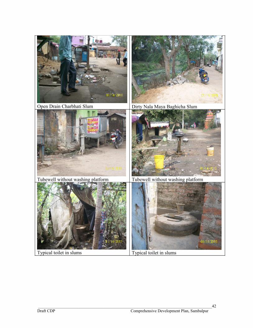
Open Drain Charbhati Slum Dirty Nala Maya Baghicha Slum
Tubewell without washing platform Tubewell without washing platform
Typical toilet in slums Typical toilet in slums
____________________________________________________________________________________42Draft CDP Comprehensive Development Plan, Sambalpur

A sample survey of 501 household (2.5% of 20,053 households) in the slums of SDA was done in June 2009 to understand the nature of development, existing infrastructure facility scenario and their expectation for development. People were asked about their priority for getting the facilities in their slums. During the survey it was found that more than 70 percent of the households have not provided the information about the type of access to sanitation facility meaning thereby they don’t have the access to proper sanitation facility and are defecating in open. This is the area where SDA as a planning authority has to concentrate in providing better facility while rehabilitating the slums in their area. Similarly, during survey it was also found that 72 percent of the 501 slum households surveyed were not satisfied with the water supply services. In fact this percentage is very high in the slums of Burla and Hirakud NAC area where 89% in Burla and 83% in Hirakud were not satisfied with the water supply service. More than 95 percent of the slums in the SDA area are mainly located along the nalla, along the main road and few along the railway line. Slums along the nalla shall have to be rehabilitated on the priority basis and other slums shall have to be provided with site and services. Atleast water supply and sanitation facility shall be improved immediately in the slum areas.
Out of 501 households that were surveyed, 226 households have given first priority to the water supply facility, 55 have given drainage as the first priority, 28 households want roads and transportation, 96 households want sewerage and sanitation facility to be improved first and only 14 have given first priority to the solid waste disposal system to be improved in their area. The survey result is shown in Table 1O and depicted in Chart 1(o) below.
Table 1OExpectation of Service Priorities in Slums of the SDA Area
First priority Water SupplySecond priority DrainageThird priority sewerage & sanitationFourth priority solid waste disposalFifth priority Roads and transport
Chart 1(o)
226
96
551428
66
103
115
4875
46
100
131
8642
4980
67
140
59
252433
114
190
89
98
100
99
107
1st 2nd 3rd 4th 5th Noresponse
EXPECTATION OF SERVICE PRIORITIES IN SLUMS OF SDA AREA
Water Supply Sewerage & Sanitation Drainage Solid Waste Disposal Roads & Transport
____________________________________________________________________________________43Draft CDP Comprehensive Development Plan, Sambalpur
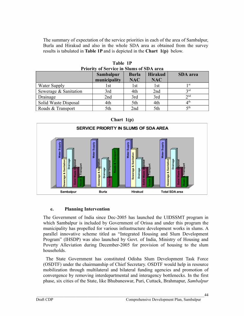
The summary of expectation of the service priorities in each of the area of Sambalpur, Burla and Hirakud and also in the whole SDA area as obtained from the survey results is tabulated in Table 1P and is depicted in the Chart 1(p) below.
Table 1PPriority of Service in Slums of SDA area
Sambalpur municipality
Burla NAC
Hirakud NAC
SDA area
Water Supply 1st 1st 1st 1st
Sewerage & Sanitation 3rd 4th 2nd 3rd
Drainage 2nd 3rd 3rd 2nd
Solid Waste Disposal 4th 5th 4th 4th
Roads & Transport 5th 2nd 5th 5th
Chart 1(p)
Wat
er S
uppl
y
Sew
erag
e &
San
itatio
n
Dra
inag
e
Sol
id W
aste
Dis
posa
l
Roa
ds &
Tra
nspo
rt
Wat
er S
uppl
y
Sew
erag
e &
San
itatio
n
Dra
inag
e
Sol
id W
aste
Dis
posa
l
Roa
ds &
Tra
nspo
rt
Wat
er S
uppl
y
Sew
erag
e &
San
itatio
n
Dra
inag
e
Sol
id W
aste
Dis
posa
l
Road
s &
Tra
nspo
rt
Wat
er S
uppl
y
Sew
erag
e &
San
itatio
n
Dra
inag
e
Sol
id W
aste
Dis
posa
l
Roa
ds &
Tra
nspo
rt
Sambalpur Burla Hirakud Total SDA area
SERVICE PRIORITY IN SLUMS OF SDA AREA
e. Planning Intervention
The Government of India since Dec-2005 has launched the UIDSSMT program in which Sambalpur is included by Government of Orissa and under this program the municipality has propelled for various infrastructure development works in slums. A parallel innovative scheme titled as “Integrated Housing and Slum Development Program” (IHSDP) was also launched by Govt. of India, Ministry of Housing and Poverty Alleviation during December-2005 for provision of housing to the slum households.
The State Government has constituted Odisha Slum Development Task Force (OSDTF) under the chairmanship of Chief Secretary. OSDTF would help in resource mobilization through multilateral and bilateral funding agencies and promotion of convergence by removing interdepartmental and interagency bottlenecks. In the first phase, six cities of the State, like Bhubaneswar, Puri, Cuttack, Brahmapur, Sambalpur
____________________________________________________________________________________44Draft CDP Comprehensive Development Plan, Sambalpur

and Rourkela have been identified to make them slum-free urban local bodies. The Task Force would prioritize the slums to be taken up for resettlement and decide appropriate projects for development.
The intervention by the government and non-government agencies in providing better infrastructure and housing facilities in the slums of Sambalpur is going to limit the growth of slums in the SDA area. Once the slums are provided with basic infrastructure facilities and better housing conditions, number of notified and non-notified slums will reduce. Because of effect of these planning interventions and holistic approach towards development in the slum area by the government and non-government agencies it will be unjustified to project the slum population in the SDA area for 2030. Even the implementation of the proposals of this CDP shall also limit the growth of the slums in the SDA area.
____________________________________________________________________________________45Draft CDP Comprehensive Development Plan, Sambalpur
![WELCOME []• “New recovery support institutions are emerging beyond the arenas of traditional addiction treatment to support inidividualshoping to initiate and sustainelong term](https://static.fdocuments.us/doc/165x107/5e8d3a7f7499a761ee4a7154/welcome-a-aoenew-recovery-support-institutions-are-emerging-beyond-the-arenas.jpg)