Challenges for Arctic Marine Transport and the Northern ...
48
Challenges for Arctic Marine Transport and the Northern Sea Route •Rapid Climate Change •Globalization ~ Arctic Natural Resources •Regional & Global Geopolitics •Indigenous Peoples Challenges Centre for International Law, National University of Singapore 23 February 2017 Lawson W. Brigham PhD ~ University of Alaska Fairbanks [email protected]
Transcript of Challenges for Arctic Marine Transport and the Northern ...

Challenges for Arctic Marine Transport
and the Northern Sea Route
•Rapid Climate Change
•Globalization ~ Arctic Natural Resources
•Regional & Global Geopolitics
•Indigenous Peoples Challenges
Centre for International Law,
National University of Singapore
23 February 2017
Lawson W. Brigham PhD ~ University of Alaska Fairbanks

Topics ~ Challenges for Arctic Marine
Transport and the NSR:
Arctic Traffic & Global Links
Changing Arctic Marine Access
NSR & Future Yamal LNG Project
Arctic Marine Shipping Assessment
Summary ~ A Plausible Future Maritime
Arctic
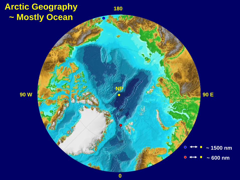
NP90 E90 W
180
0
~ 1500 nm
~ 600 nm
Arctic Geography
~ Mostly Ocean
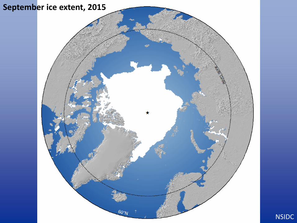
September ice extent, 2015
NSIDC

September ice extent, 2015
NSIDC, AMSA

Maritime Traffic 1 June to 30 November 2013Marine Exchange of Alaska

Maritime Traffic
1 Jan to 31 May 2014
Marine Exchange of Alaska

Arctic Linkages to the Global
Economic System
• International Fishing (10%)
• Hard Minerals ~ Palladium (40%), Nickel (22%),
Diamonds (20%), Platinum (15%), Zinc (10%)
• Estimated Arctic Hydrocarbons ~ Undiscovered Natural
Gas (30%) & Oil (13%)
• Potential: Rare Earths (25%), Coal & Fresh Water
• Global Marine Tourism industry
• Regional Trade to Northern Communities &
Infrastructure Development

U.S. Geological Survey Report ~ July 2008
–13% Undiscovered Oil
–30% Undiscovered Natural Gas
–20% Undiscovered Natural Gas Liquids
“Circum-Arctic Resource
Appraisal: Estimates of
Undiscovered Oil and Gas North
of the Arctic Circle”
http://pubs.usgs.gov/fs/2008/3049/
New Arctic Resource Discoveries

New Arctic Resource Discoveries
USGS (2008)
Probability of Presence of
Undiscovered Oil and/or Gas
Fields
Coastal Seas

Today’s Maritime Arctic
(200 NM Exclusive Economic Zone)Hypothetical - Future Maritime Arctic
(After UNCLOS Article 76)
The ILULISSAT Declaration
Conference of 5 Coastal States Bordering on the Arctic Ocean (Canada,
Denmark & Greenland, Norway, Russia, USA)
27-29 May 2008 ~ Ilulissat, Greenland
LOS/UNCLOS Provides ‘Solid Foundation’
‘We therefore see no need to develop a new comprehensive international
legal regime to govern the Arctic Ocean.’
(Macnab 2000) (Macnab 2000)

Present Sea Ice Retreat ~ Outside the Range
of Model Projections
2007 2008
• 2012
2009

Changing Summer Arctic Sea Ice
Coverage ~ 1979-2012

Arctic Sea Ice Minimum Extents ~
2007 & 2012
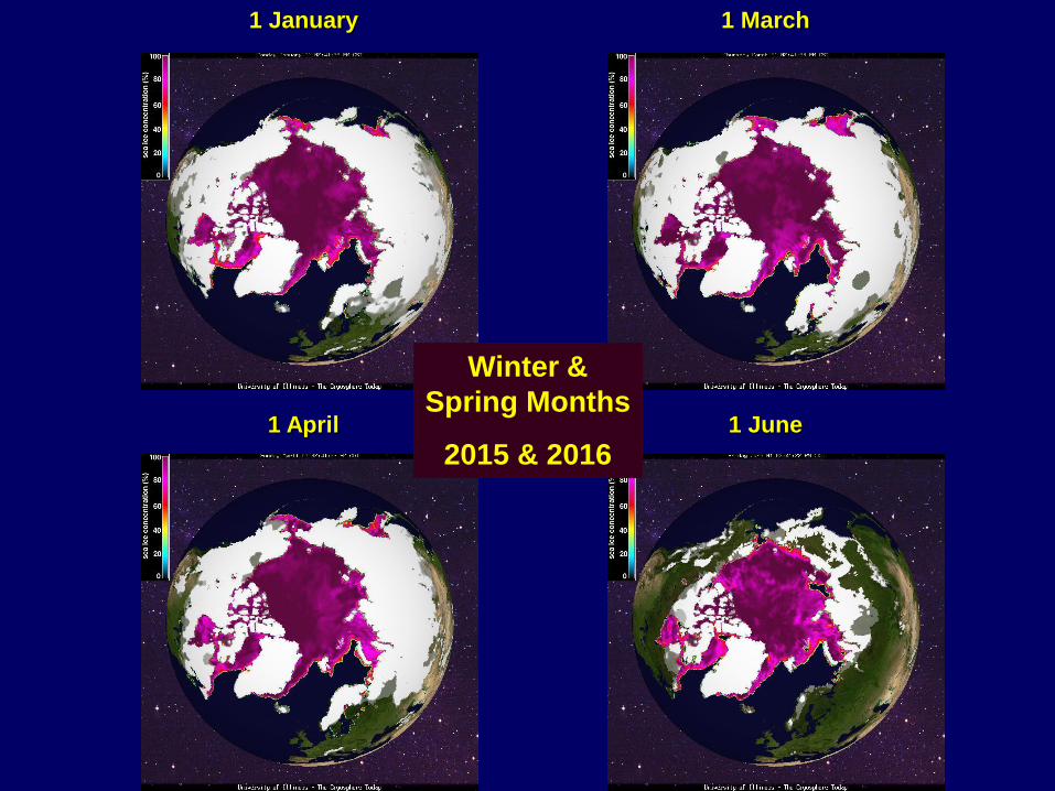
1 January 1 March
1 April 1 June
Winter &
Spring Months
2015 & 2016

• PC 1 ~ Year-round operation in all ice-covered waters
• PC 2 ~ Year-round operation in moderate multi-year ice conditions
• PC 3 ~ Year-round operation in second-year ice which may include multi-
year ice inclusions
• PC 4 ~ Year-round operation in thick first-year ice which may include old ice
inclusions
• PC 5 ~ Year-round operation in medium first-year ice which may include old
ice inclusions
• PC 6 ~ Summer/autumn operation in medium first-year ice which may
include old ice inclusions
• PC 7 ~ Summer/autumn operation in thin first-year ice which may include
old ice inclusions.
** Ice descriptions follow the World Meteorological Organization (WMO) sea-
ice nomenclature
IACS Polar Class Ship Descriptions

Septembers
2006-2015
red lines=
Polar Class 6
(e.g. commercial
icebreaking ships)
blue lines=
common open-
water ships
Northwest
Passage: 236
Transits
1906-2015
Northern Sea
Route Transits:
37/2013, 23/2014

Septembers
2040-2059
red lines=
Polar Class 6
(e.g. commercial
icebreaking ships)
blue lines=
common open-
water ships
(“New Trans-Arctic
shipping routes
navigable by
midcentury”, L.C.
Smith and S.R.
Stephenson, PNAS,
2013)

Summer Northern Sea Route Voyages Linking Arctic Russia to
Northern Europe & to the Pacific
12 SEPT
31 AUG
NSR Full Transits:
2011~ 16
2012~ 27
2013~ 37
2014~ 23
2015~ 18
2016~ 18
Data: ANSR
23 JUL

1. Kara Gate strait (~10-40 m)2. Vilkitsky Strait (100-200 m)3. Sannikov Strait (13 m)4. Dmitry Laptev Strait (6.7 m)5. Long Strait (33 m)
r2 = .57Accessible Days vs. Depth
1 2
3
5
4
> 20,000 dwt
Stephenson et al. 2014, Polar Geography

Annual Navigation Season for Polar Class 3 Ships (2013-2027 mean)
Black:
mean
Gray: stdev
Longitude East
Accessib
le
days p
er
year
Barents Sea
Kara Sea
Laptev Sea
East Siberian
Sea
Chukchi Sea
high avg/
low stdev
high avg/
high
stdev
low avg/
high
stdev
low avg/
low stdev
Barents Kara Laptev East Siberian Chukchi

Dec
Jan
Feb
Mar
Ap
rM
ay
Longitude East
Polar Class 3 shipsBarents Kara Laptev E. Siberian Chukchi
Open-water shipsBarents Kara Laptev E. Siberian Chukchi
Accessible days per month (DJFMAM) in Russian Arctic Coastal Seas, 40-190°E (2013-2027 mean)
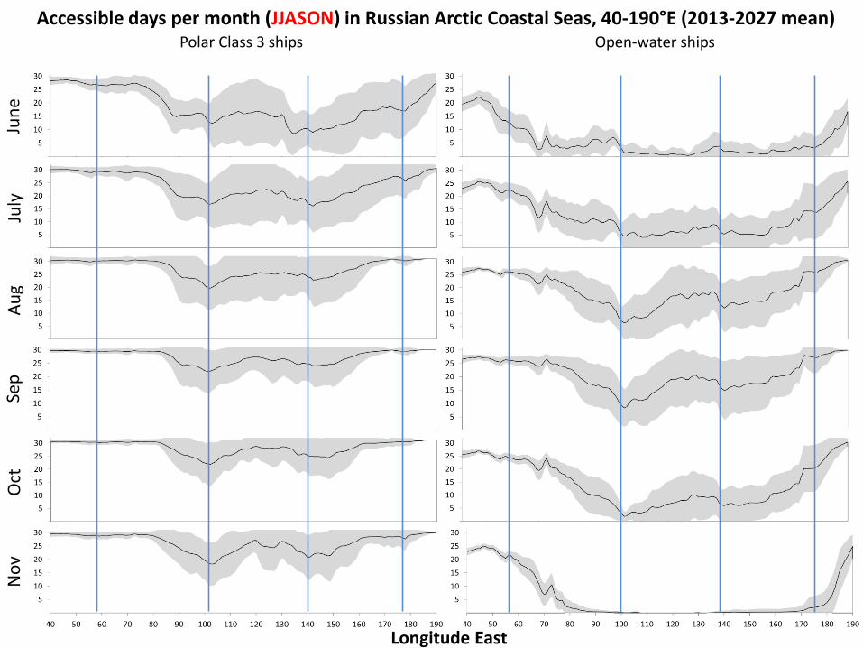
Jun
eJu
lyA
ug
Sep
Oct
No
v
Longitude East
Accessible days per month (JJASON) in Russian Arctic Coastal Seas, 40-190°E (2013-2027 mean)Polar Class 3 ships
Barents Kara Laptev E. Siberian ChukchiOpen-water ships
Barents Kara Laptev E. Siberian Chukchi

24
YAMAL Arc7 LNG Carrier PROJECT
25
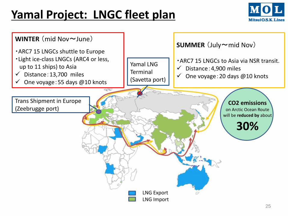
Yamal Project: LNGC fleet plan
SUMMER (July~mid Nov)
・ARC7 15 LNGCs to Asia via NSR transit. Distance:4,900 miles One voyage:20 days @10 knots
Yamal LNG Terminal (Savetta port)
WINTER (mid Nov~June)
・ARC7 15 LNGCs shuttle to Europe・Light ice-class LNGCs (ARC4 or less,
up to 11 ships) to Asia Distance:13,700 miles One voyage:55 days @10 knots
Trans Shipment in Europe (Zeebrugge port)
LNG ExportLNG Import
CO2 emissions on Arctic Ocean Route
will be reduced by about
30%

YAMAL ARC7 LNGCs - Vessel Specification (1)
26
• Principal ParticularsARC7 LNGC (15 vessels): Principal Particulars
Builder & Delivery year DSME Shipyard Korea, Delivery Year: 2016:(1), 2017:(4), 2018:(5), 2019:(5)
Ship Owners Sovcomflot (1), Teekay (6), Dynagas (5), MOL (3)
Classification Society Class BV & RMRS
Ship Dimension Loa 299m x B 50m x D 26.5m x Ice draft 12.0 m
Cargo Tank GTT No96 Membrane, 172,600 m3 (100% filled)
Propulsion AZIPOD 3 units (DFDE Generator 6 sets)
Ice Class RMRS ARC-7 (1st year ice, 210cm thick), Winterization -52 deg.C.
Double Acting LNG Carrier

Multiple option of transit routesAccess to potential energy resource in Arctic ocean
Arctic water accounts:17% of discovered natural gas in the world30% of undiscovered natural gas in the world
<Outstanding>•Ice navigation Crew training•Crew health: Polar night/Polar day•Infrastructures: SAR station(Search & Rescue), Repair dockyard, Airport•Custom clearance in Russia •Bathymetry data (insufficient navigation chart)•Ice map provider - Weather forecasting system
27
Cargo Tonnage Along the Northern Sea Route(Source: Rosatomflot)
(Unit: kilo DW tons)

Yong Sheng
“Of the 18 vessels going transit on the NSR in 2015, ten were Russian, two were Chinese, one Dutch and one Swedish. The Chinese general cargo carrier «Yong Sheng», which shipped twice along the route, alone accounted for more than 75 percent of the 2015 NSR cargo” Carmel (2016)
http://www.thebarentsobserver.com/industry/2016/02/historical-low-northern-sea-route

This does not carry global international trade on any scale
This does
Carmel (2016)


Maersk Triple E
Type: Container ship
Tonnage: 165,000 DWT
Displacement: 55,000 tonnes (empty)[1]
Length: 400 m (1,312 ft)
Beam: 59 m (194 ft)
Draft: 16 m (52 ft)
Carmel (2016)

Arctic Council ~ Intergovernmental Forum
AMSA Lead Countries for PAME ~ Canada, Finland & USA
AMSA Focus ~ Marine Safety & Marine Environmental Protection
13 Major Workshops & 14 Town Hall Meetings
Key Challenge ~ Many Non-Arctic Stakeholders
2004 – 2009

Arctic Ministers’ Approval 29 April 2009 ~
Negotiated Recommendations & Text
Table of Contents
• Executive Summary
with Recommendations
• Arctic Marine Geography
Climate & Sea Ice
• History
• Governance
• Current Use/Database
• Scenarios to 2020 & 2050
• Human Dimensions
• Environmental Impacts
● Infrastructure
www.pame.is

AMSA Key Uncertainties for Future
Arctic Marine Transportation
• Stable legal climate
• Radical change in global trade
dynamics
• Climate change is more disruptive
sooner
• Safety of other routes
• Socio-economic impact of global
weather changes
• Oil prices (55-60 to 100-150 USD?)***
• Major Arctic shipping disasters***
• Limited windows of operation
(economics)
• Rapid climate change
• Maritime insurance industry
• China, Japan & Korea become
Arctic maritime nations
• Transit fees
• Conflict between indigenous &
commercial use
• Arctic maritime enforcement
• Escalation of Arctic maritime
disputes
• Shift to nuclear energy***
• New resource discovery
• World trade patterns
• Catastrophic loss or change in
Suez or Panama Canals
• Global agreements on
construction rules and standards

unstable
& ad-hoc
stable &
rules-based
less demand
more demand
Arctic Race Arctic Saga
Polar Lows Polar Preserve
GOVERNANCE
RE
SO
UR
CE
S
&
TR
AD
EHigh demand and unstable
governance set the stage for
an economic ‘rush’ for Arctic
wealth and resources.
High demand and stable
governance lead to a healthy
rate of development, includes
concern for preservation of
Arctic ecosystems & cultures.
Low demand and unstable
governance bring a murky
and under-developed future
for the Arctic.
Low demand & stable
governance slow development
in the region while introducing
an extensive eco-preserve with
stringent “no-shipping zones”.
AMSA/GBN Scenarios Workshops ~ April & July 2007
The Future of Arctic Marine Navigation in 2050
Scenarios on the Future of
Arctic Marine Navigation in 2050

Enhancing
Arctic Marine
Safety
Protecting
Arctic People
and the
Environment
Building the
Arctic Marine
Infrastructure
AMSA RECOMMENDATIONS (17) ~ THEMES

AMSA Recommendations
I. Enhancing Arctic Marine Safety
A. Linking with International Organizations **[IMO, WMO, IHO, IALA]
B. IMO Measures for Arctic Shipping **[IMO Polar Code]
C. Uniformity of Arctic Shipping Governance
D. Strengthening Passenger Ship Safety in Arctic Waters
E. Arctic SAR Instrument **[Arctic State 2011 Arctic SAR Binding Agreement]
II. Protecting Arctic People and the Environment
A. Survey of Arctic Indigenous Marine Use **[Ongoing]
B. Engagement with Arctic Communities **[Ongoing]
C. Areas of Heightened Ecological and Cultural Significance **[AMAP/CAFF/SDWG
Identification of Arctic marine areas of heightened & cultural significance]
D. Specially Designated Arctic Marine Areas
E. Protection from Invasive Species

AMSA Recommendations (Continued)
F. Oil Spill Prevention **[AC TF Arctic Marine Cooperation]
G. Addressing Impacts on Marine Mammals **[IWC Engagement/Workshop]
H. Reducing Air Emissions
III. Building the Arctic Marine Infrastructure
A. Addressing the Infrastructure Deficit
B. Arctic Marine Traffic Systems **[Enhanced AIS Monitoring]
C. Circumpolar Environmental Response Capacity **[Arctic State Binding 2013 Arctic Oil
Spill Preparedness & Response Agreement]
D. Investing in Hydrographic, Meteorological & Oceanographic Data


Amendments to SOLAS, MARPOL & STCW
Commercial Carriers & Passenger Ships (500 tons or more)
I. SOLAS Amendments:
• Polar Ship’s Structural & Equipment Standards (Ice Classes: PC1/ PC7)
• Marine Safety and Lifesaving Equipment
• Training & Experience of Polar Mariners
• Polar Ship Certificate (Flag State ~ Ship Classes A,B,C)
• Polar Water Operations Manual (Ship Specific)
II. Environmental Rules ~ MARPOL Annexes:
• Annex I ~ Oil & Oily Mixtures (No Discharge)
• Annex II ~ Noxious Liquid Substances (No Discharge)
• Annex IV ~ Sewage
• Annex V ~ Food Waste/Garbage
Elements of the IMO Mandatory Polar CodeProcess ~ 1993 to 1 January 2017

IMO Guidelines &Mandatory Polar Code: Maximum Extent
of Antarctic Waters Application (IMO)

IMO Guidelines & Mandatory Polar Code: Maximum Extent
of Arctic Waters Application (IMO)

IMO Polar Code: Maximum Extent of Arctic Waters Application
(U.S. Department of State)

Summary ~ A Plausible Future Maritime Arctic
• Peaceful & Arctic State Cooperation
• More Engagement of the Non-Arctic States

Summary ~ A Plausible Future Maritime Arctic
• Peaceful & Arctic State Cooperation
• More Engagement of the Non-Arctic States
• Storehouse of Vast Natural Resources: Require Marine
Transport Systems & Support Infrastructure
• Several Arctic States: Natural Resources Critical to
Their National Economies (Russia, Norway, Greenland)
• Profound Climate Change Influencing the Planet: Continued Sea Ice Retreat & New Marine Access
• Unlikely to Retool Global Trade Routes, But
Increasing Marine Operations
• Increasing Arctic Ocean Protection/Safety Measures