
Challanged Ground Water Foot Prints, “A Pressure Indicator ... · Ujjain is witnessing one of the...
8
IOSR Journal of Applied Chemistry (IOSR-JAC) e-ISSN: 2278-5736.Volume 9, Issue 6 Ver. I (Jun. 2016), PP 28-35 www.iosrjournals.org DOI: 10.9790/5736-0906012835 www.iosrjournals.org 28 |Page Challanged Ground Water Foot Prints, “A Pressure Indicator” For Upcoming Ujjain Ground Water Crisis, An Analysis In Simhastha 2016 Context Dr. KalpanaVirendra Singh 1 , Anil Prajapati 2 Sumanshu Sharma 3 1. P.G. Department of Chemistry and Pharmaceutical Chemistry,Govt. Madhav Science P.G.College Ujjain [M.P.] 2. Department of Computer Science, Govt. Madhav Science P.G.College Ujjain [M.P.] 3. Department of Computer application , Govt. Madhav Science P.G.College Ujjain [M.P. ] Abstract: Civilizations have developed around Water all over the world. Water is the median for development and plays vital role in socio-economic development. Nation's principal reserve of fresh water is ground water;it is also the most preferred resource to meet various requirements. More than 90% of rural and 50% of urban population is dependent on ground water sources in M.P. Ground water is also major source of irrigation in Madhya Pradesh and about 6,714,300 hectare of land is irrigated through ground water according to ground water report submitted in 2013. As per the well census of 2013, there are around 4369672 ground water abstraction structures with an estimated annual ground water draft of about 18 Billion Cubic Meter and the number is still swelling. There are reports from all over the state about drying up of a large number of dug wells/ bore wells in some areas due to declining ground water levels and this has jeopardized irrigation, industrial and domestic needs in Madhya Pradesh. Demands for safe drinking water are increasing and there are growing concerns about the scientific chemical parameters of water. Water quality issues related to geogenic contamination such as fluoride, anthropogenic contamination such as nitrate and inland salinity are the matter of concern. Ujjain also had disturbed and varied rainy seasosn during past decade. City saw a major decline in the green cover owing to the cropping up of housing infrastructures and business endeavors. This year from April 22 nd to June 21 st Ujjain will witness The Simhastha Mahaparva . This Simhastha Mahaparva will welcome 5crore pilgrims across the Globe. Govt. has left no stone unturned, but are we really prepared in terms of ground water ,the present paper will look into the scientific issues related to ground water scenario of Ujjain in pre Simhastha and Post Simhastha clock. Keywords: Ground Water, Geogenic contamination, anthropogenic contamination, Simhastha. I. Introduction Ground water is a fundamentally important resource, necessary for socio economic development of a country. It is crucial for mitigating ever expanding needs of drinking water as well as Industrial water requirements. Madhya Pradesh is a land-locked state with an area of 3,08,252 km 2 situated in the central region of India, sharing boundaries with Chhattisgarh in the east , Gujrat in the west Rajasthan in the northwest , Uttar Pradesh on the northeast and Maharashtra on the southern border.It is situated between north latitudes 21 ° 04' and 26 ° 54' and east longitudes 74 ° 00' and 82 ° 50'. As per census of 2011 state has population of 7,25,97,565.Population density distribution is 236 persons per Km 2 area. 75% of the total population lives in villages ,agriculture being the main occupation .More than 90% of the rural and 50% of Urban population is dependent on ground water sources in M.P.Ground water being the major source of irrigation . According to ground water report submitted in 2013 about 6,714,300 hectare of land is irrigated through ground water .There are reports about declining Ground water levels throughout the state. Ground water has also proved to be an important resource to meet the rapidly expanding demand of drinking water. Ujjain is a city of religious importance belonging to Malwa plateauregion of M.P. The plateau is located in the northwest of the State and north of the Vindhya Range. Ujjain is witnessing one of the largest conglomerations of religious pilgrims stated as Simhastha 2016 from 22 nd of April to 21 st of May 2016. Till 09 th of May 2016 as per officially shared data city has already welcomed 60 Lakh pilgrims and still there are 12 days to go. Subjected to realization most probably more than 100 Lakh pilgrims will take dip in Holy Shipra river by the end date i.e.21 st of May 2016.Ujjain has experienced varied rainy season during the past decade and owing to depletion of green cover, cropping up of housing infrastructure and big business endeavors, city once popular for its pleasant nights, cool mornings and not so hot days is scorching under heat in summer afternoons with temperature rising up to even 42℃ .Reports about receding water tables are thereand there are growing concerns about the scientific chemical parameters of water. Water quality issues related to geogenic contamination such as fluoride, anthropogenic contamination such as nitrate and inland salinity are the matter of concern. Tracking of changes
Transcript of Challanged Ground Water Foot Prints, “A Pressure Indicator ... · Ujjain is witnessing one of the...
IOSR Journal of Applied Chemistry (IOSR-JAC)
e-ISSN: 2278-5736.Volume 9, Issue 6 Ver. I (Jun. 2016), PP 28-35
www.iosrjournals.org
DOI: 10.9790/5736-0906012835 www.iosrjournals.org 28 |Page
Challanged Ground Water Foot Prints, “A Pressure Indicator”
For Upcoming Ujjain Ground Water Crisis, An Analysis In
Simhastha 2016 Context
Dr. KalpanaVirendra Singh1, Anil Prajapati
2 Sumanshu Sharma
3
1.P.G. Department of Chemistry and Pharmaceutical Chemistry,Govt. Madhav Science P.G.College Ujjain
[M.P.] 2.Department of Computer Science, Govt. Madhav Science P.G.College Ujjain [M.P.]
3.Department of Computer application , Govt. Madhav Science P.G.College Ujjain [M.P. ]
Abstract: Civilizations have developed around Water all over the world. Water is the median for development
and plays vital role in socio-economic development. Nation's principal reserve of fresh water is ground water;it
is also the most preferred resource to meet various requirements. More than 90% of rural and 50% of urban
population is dependent on ground water sources in M.P. Ground water is also major source of irrigation in
Madhya Pradesh and about 6,714,300 hectare of land is irrigated through ground water according to ground
water report submitted in 2013. As per the well census of 2013, there are around 4369672 ground water
abstraction structures with an estimated annual ground water draft of about 18 Billion Cubic Meter and the
number is still swelling. There are reports from all over the state about drying up of a large number of dug
wells/ bore wells in some areas due to declining ground water levels and this has jeopardized irrigation,
industrial and domestic needs in Madhya Pradesh. Demands for safe drinking water are increasing and there
are growing concerns about the scientific chemical parameters of water. Water quality issues related to
geogenic contamination such as fluoride, anthropogenic contamination such as nitrate and inland salinity are
the matter of concern. Ujjain also had disturbed and varied rainy seasosn during past decade. City saw a major
decline in the green cover owing to the cropping up of housing infrastructures and business endeavors. This
year from April 22nd
to June 21st Ujjain will witness The Simhastha Mahaparva . This Simhastha Mahaparva
will welcome 5crore pilgrims across the Globe. Govt. has left no stone unturned, but are we really prepared in
terms of ground water ,the present paper will look into the scientific issues related to ground water scenario of
Ujjain in pre Simhastha and Post Simhastha clock.
Keywords: Ground Water, Geogenic contamination, anthropogenic contamination, Simhastha.
I. Introduction
Ground water is a fundamentally important resource, necessary for socio economic development of a
country. It is crucial for mitigating ever expanding needs of drinking water as well as Industrial water
requirements. Madhya Pradesh is a land-locked state with an area of 3,08,252 km2 situated in the central region
of India, sharing boundaries with Chhattisgarh in the east , Gujrat in the west Rajasthan in the northwest ,
Uttar Pradesh on the northeast and Maharashtra on the southern border.It is situated between north latitudes 21°
04' and 26° 54' and east longitudes 74
° 00' and 82
° 50'. As per census of 2011 state has population of
7,25,97,565.Population density distribution is 236 persons per Km2 area. 75% of the total population lives in
villages ,agriculture being the main occupation .More than 90% of the rural and 50% of Urban population is
dependent on ground water sources in M.P.Ground water being the major source of irrigation . According to
ground water report submitted in 2013 about 6,714,300 hectare of land is irrigated through ground water .There
are reports about declining Ground water levels throughout the state. Ground water has also proved to be an
important resource to meet the rapidly expanding demand of drinking water. Ujjain is a city of religious
importance belonging to Malwa plateauregion of M.P. The plateau is located in the northwest of the State and
north of the Vindhya Range. Ujjain is witnessing one of the largest conglomerations of religious pilgrims stated
as Simhastha 2016 from 22nd
of April to 21st of May 2016. Till 09
th of May 2016 as per officially shared data
city has already welcomed 60 Lakh pilgrims and still there are 12 days to go. Subjected to realization most
probably more than 100 Lakh pilgrims will take dip in Holy Shipra river by the end date i.e.21st of May
2016.Ujjain has experienced varied rainy season during the past decade and owing to depletion of green cover,
cropping up of housing infrastructure and big business endeavors, city once popular for its pleasant nights, cool
mornings and not so hot days is scorching under heat in summer afternoons with temperature rising up to
even 42℃ .Reports about receding water tables are thereand there are growing concerns about the scientific
chemical parameters of water. Water quality issues related to geogenic contamination such as fluoride,
anthropogenic contamination such as nitrate and inland salinity are the matter of concern. Tracking of changes
Challenged Ground Water Foot Prints, “A Pressure Indicator” For Upcoming Ujjain Ground..
DOI: 10.9790/5736-0906012835 www.iosrjournals.org 29 |Page
in the ground water regime and its periodic monitoring is an essential prerequisite for effective planning ,
management and sustenance of quantity as well quality of this precious resource.
II. Hydrogeology of Madhya Pradesh Madhya Pradesh has diverse hydrogeological characteristics resulting into varied water potential at
different places.More than 80% of the total land area of the state is covered by variety of hard rocks varying in
geological structures, geomorphological set up and hydro meteorological conditions. State has following
hydrogeological units:
1. Archeans: comprising of old metamorphic rocks, granites, gneisses and schiests. They have very low primary
permeability and form poor aquifers
2. Vindhyans: Comprise of sand stone, shale and limestone. Sand Stone and Shale are hard and compact
forming poor aquifers, Limestone has secondary permeability
3. Gondwans: Sedimentary formations rich in granular zones and form good aquifers
4. InfraTrappeans: Sedimentary formations but have a limited extent and poor to moderate permeability
5. Deccan Traps: The weathered, fractured , jointed and vesicular units of Basalts form moderate to good
aquifers, this type of units form the most important aquifers in the region. They occupy the Malwa Plateau
6. Alluvium: comprises of unconsolidated gravel, sand , silt clay in various proportions, has primary
intergranular porosity and permeability. They form very good aquifers
Table1. Hydrogeological group belonging to Malwa Plateau Geological Age Hydrogeological
Group Rock Formation
Surface Exposure
Area
Occurrence
Creataceous
Deccan Trap Basalts 1,43,300 Malwa plateau covering Nimuch, Mandsaur, Indore,Ujjain, Ratlam, Shajapur, Sagar, Rajgarh, Sehore, Badwani,
KhargonBurhanpur districts and parts of Jhabua, Raisen, Guna,
Ashok Nagar, Bhopal, Sehore, Betul, Jabalpur, Katni, Hoshangabad,Chhindwara, Seoni, Dindori, Mandla, Shahdol and
Anuppur
III. Ground Water Quantity, an analysis 3.1 Monsoon rainfall distribution during the year 2014
Ground water levels are maintained through regular discharge and recharge phenomenon .Rainfall
during monsoon period is the sole source of natural recharge to ground water and rainfall pattern has an impact
on ground water levels. Madhya Pradesh experiences most rainfall during south- west mon soon season i.e.
from mid June to September. The rainfall data for 2014 for Ujjain is given in Table II.
TableII: Rainfall in Ujjain - 2014 Sr. No. Name of Station Normal rainfall Actual rainfall %Departure wrt
Monsoon (01.06.2014 to Normal Monsoon
(1st June- 30th Sept) 30.09.2014) Rainfall-2014
48 Ujjain 833.7 573.7 -31
Source:www.imd.gov.in
The isohyetal map of monsoon rainfall 2014 for whole Madhya Pradesh is given in Fig 1. Where
Monsoon rainfall within ± 19% of the normal monsoon rainfall is considered as normal rainfall
Monsoon rainfall less than -19% and more than -59% of the normal monsoon rainfall is considered deficit
lesser than -59% of the normal monsoon rainfall, it is considered scanty rainfall.

Challenged Ground Water Foot Prints, “A Pressure Indicator” For Upcoming Ujjain Ground..
DOI: 10.9790/5736-0906012835 www.iosrjournals.org 30 |Page
Figure: 1
Acknowledgement: Ground Water Year Book - Madhya Pradesh (2014-15)
As clear from the figure state has received 20.00 % less rainfall with respect to the normal rainfall. The percent
monsoon rainfall departure from normal rainfall map of Madhya Pradesh for the year 2014 is presented in Fig.II
Figure: II
Acknowledgement: Ground Water Year Book - Madhya Pradesh (2014-15)
As per figure IandFigureIIits evident that Ujjain received deficit rainfall during Summer monsoon period in
2014.
3.2Analyses of ground water levels
Planning, management ,sustenance of quantity as well as quality of ground water resource depends
upon the periodic monitoring of the ground water regime. Central Ground Water Board monitors ground water
level four times in a year, i.e. during May, August, November and January, through a network of Ground Water
monitoring Wells

Challenged Ground Water Foot Prints, “A Pressure Indicator” For Upcoming Ujjain Ground..
DOI: 10.9790/5736-0906012835 www.iosrjournals.org 31 |Page
Figure III: Location of ground water monitoring wells in Madhya Pradesh (2014-15)
Acknowledgement: Ground Water Year Book - Madhya Pradesh (2014-15)
Table III: Number of monitoring stations at Ujjain as per reports byCentral Ground Water Board No of monitoring stations No of monitoring stations
S No. District As on 31-03-2014 As on 31-03-2015
DW PZ Total DW PZ Total
1 Ujjain 26 26 52 26 26 52
3.2.1 Depth to water level May 2014
Mayis the pre monsoon month and as per reports of central ground water Board depth of water level
ranges from 0.83 to 49.40 m bgl in whole state.0.71% of wells in sporadic patches recorded very shallow water
level up to 2 m bgl. Very deep ground water level of 20-40 m bgl are found in about 3.53% of the wells and
occur mainly in Burhanpur, Indore, Ujjain , Mandsaur, Chhindwara, Gwalior, Narsinghpur, morena and Bhind
districts.
3.2.2Depth to water level August 2014
August is the monsoon month and depth of ground water level range from 0.8 to 49.00 m bgl in the
whole state. very shallow water levels up to 2m bgl are seen in almost entire state. 28.33% of monitoring wells
recorded very shallow water level less than 2m bgl. Deeper ground water level of more than 20m are found in
1.58% of wells. Extremely deeper ground water levels of more than 40 m bgl are found in Bhind district
only.Ujjain also recorded shallow water levels in the records taken for the month of August
3.2.3. Depth to water level November 2014
November is the post monsoon month .Depth of water levels ranges from 0.21 bgl to 49.00 m bgl in
Madhya Pradesh.7.68% of monitoring wells recorded water level less than 2 m bgl. About 36.84%of wells
spreading over the state recorded a water level in the depth range of 2-5 m bgl.37.88% of wells recorded deeper
ground water level in the range of 10-20 m bgl.
3.2.4Depth to water level January 2015
January is a post monsoon winter month when environment is comparatively cooler with temperature
not soaring high. Depth of water levels range from 0.21 m bgl to 49.00 m bgl in Madhya Pradesh. Very shallow
water levels are seen in some pockets.28.18% of monitoring wells has recorded water level in the depth of 2-5
m bgl. 44.16% of wells have water level ranging between 5-10 m bgl. 19.44% of wells have deeper ground
water level ranging 10-20 m bgl. 3.39% of wells have water level at more than 20 m which is considered as an
alarming situation Ujjain falls in this category with other districts like Indore, Dhar, Mandsaur and Ratlam

Challenged Ground Water Foot Prints, “A Pressure Indicator” For Upcoming Ujjain Ground..
DOI: 10.9790/5736-0906012835 www.iosrjournals.org 32 |Page
Figure IV: Water level Fluctuation Map of Madhya Pradesh (May 2014-August 2014)
Figure V: Water Level Fluctuation Map of Madhya Pradesh (May 2014-Nov.2014)
Acknowledgement Figure IV and V: Ground Water Year Book - Madhya Pradesh (2014-15)
Figure VI: Water Level Fluctuation Map of Madhya Pradesh (May 2014-Jan 2015)
Acknowledgement: Ground Water Year Book - Madhya Pradesh (2014-15)
Challenged Ground Water Foot Prints, “A Pressure Indicator” For Upcoming Ujjain Ground..
DOI: 10.9790/5736-0906012835 www.iosrjournals.org 33 |Page
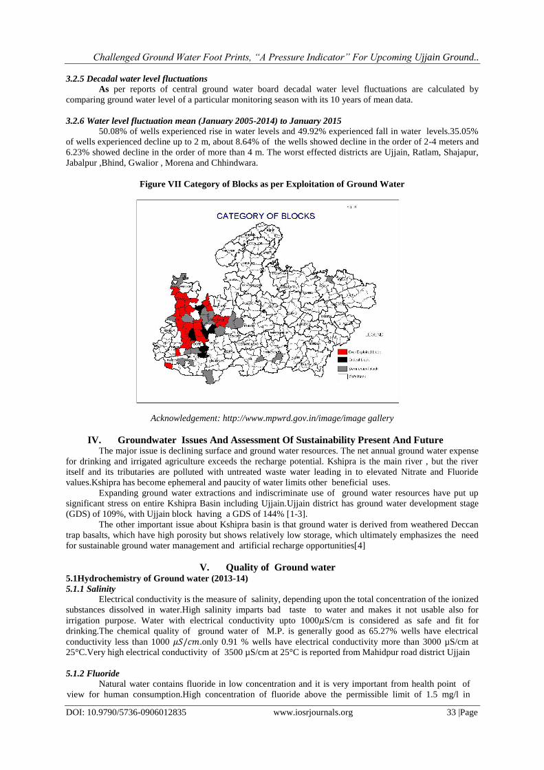
3.2.5 Decadal water level fluctuations
As per reports of central ground water board decadal water level fluctuations are calculated by
comparing ground water level of a particular monitoring season with its 10 years of mean data.
3.2.6 Water level fluctuation mean (January 2005-2014) to January 2015
50.08% of wells experienced rise in water levels and 49.92% experienced fall in water levels.35.05%
of wells experienced decline up to 2 m, about 8.64% of the wells showed decline in the order of 2-4 meters and
6.23% showed decline in the order of more than 4 m. The worst effected districts are Ujjain, Ratlam, Shajapur,
Jabalpur ,Bhind, Gwalior , Morena and Chhindwara.
Figure VII Category of Blocks as per Exploitation of Ground Water
Acknowledgement: http://www.mpwrd.gov.in/image/image gallery
IV. Groundwater Issues And Assessment Of Sustainability Present And Future The major issue is declining surface and ground water resources. The net annual ground water expense
for drinking and irrigated agriculture exceeds the recharge potential. Kshipra is the main river , but the river
itself and its tributaries are polluted with untreated waste water leading in to elevated Nitrate and Fluoride
values.Kshipra has become ephemeral and paucity of water limits other beneficial uses.
Expanding ground water extractions and indiscriminate use of ground water resources have put up
significant stress on entire Kshipra Basin including Ujjain.Ujjain district has ground water development stage
(GDS) of 109%, with Ujjain block having a GDS of 144% [1-3].
The other important issue about Kshipra basin is that ground water is derived from weathered Deccan
trap basalts, which have high porosity but shows relatively low storage, which ultimately emphasizes the need
for sustainable ground water management and artificial recharge opportunities[4]
V. Quality of Ground water 5.1Hydrochemistry of Ground water (2013-14)
5.1.1 Salinity
Electrical conductivity is the measure of salinity, depending upon the total concentration of the ionized
substances dissolved in water.High salinity imparts bad taste to water and makes it not usable also for
irrigation purpose. Water with electrical conductivity upto 1000𝜇S/cm is considered as safe and fit for
drinking.The chemical quality of ground water of M.P. is generally good as 65.27% wells have electrical
conductivity less than 1000 𝜇𝑆/𝑐𝑚.only 0.91 % wells have electrical conductivity more than 3000 µS/cm at
25°C.Very high electrical conductivity of 3500 µS/cm at 25°C is reported from Mahidpur road district Ujjain
5.1.2 Fluoride
Natural water contains fluoride in low concentration and it is very important from health point of
view for human consumption.High concentration of fluoride above the permissible limit of 1.5 mg/l in
Challenged Ground Water Foot Prints, “A Pressure Indicator” For Upcoming Ujjain Ground..
DOI: 10.9790/5736-0906012835 www.iosrjournals.org 34 |Page
drinking water is harmful for human consumption. Fluoride rich water occurs in shallow aquifers in Ujjain
district. According to a pilot study by govt. of India and Ayush Department Ujjain is marked for further
studies related to fluoride contamination and identification of cases related to Fluorosis.
5.1.3 Nitrate
Nitrate naturally occurs in ground water in very low concentration as contribution of Nitrate through
geo genic impurities in ground water is almost neglegeble. Anthropogenic activities are the major contributers
for elevated Nitrate concentrations. Sewage and animal waste contain considerable amount of Nitrate and after
discharge on land it gets leached out by rainfall causing enrichment of Nitrate in ground water.Faulty
Agricultural practices like excessive use of fertilizers, irrigation with waste waters, legumes and farm yard
wastes contribute Nitrate to ground water. Concentration of Nitrate in excess of 45 mg/l in water is harmful for
human consumption, particularily in infants it causes blue baby disease.
In Madhya Pradesh, nitrate concentration in shallow aquifer occurs in Anuppur, Balaghat, Barwani,
Betul, Bhind, Bhopal, Chhatarpur, Chhindwara, Damoh, Datia, Dewas, Dhar, Guna, Gwalior, Harda,
Hoshangabad, Indore, Jabalpur, Jhabua, Katni, Khandwa, Khargone, Mandla, Mandsaur, Morena, Narsinghpur,
Nimuch, Panna, Raisen, Rajgarh, Ratlam, Rewa, Sagar, Satna, Sehore, Seoni, Shahdol, Shajapur, Sheopur,
Shivpuri, Sidhi, Tikamgarh, Ujjain, Umaria and Vidisha districts.
The locaions having more than 45 mg/l nitrate in ground water of Ujjain district are shown in Table IV.
Table IV Locations showing nitrate more than 45 mg/l in ground water S.No. Districts Block Location NO3 (mg/l)
367 Ujjain BADNAGAR Dablahardu 190
368 Ujjain GHATIA Bachhukhera 52
369 Ujjain MAHIDPUR Baijnath 118
370 Ujjain MAHIDPUR Delchibuzurg 205
371 Ujjain MAHIDPUR Mahidpurroad 136
372 Ujjain MAHIDPUR Mahidpurtown 48
373 Ujjain TARANA Rupakhedi 114
374 Ujjain UJJAIN Chandukhedi 101
375 Ujjain UJJAIN Palkhanda 87
376 Ujjain UJJAIN Patpala 220
377 Ujjain Tajpur 60
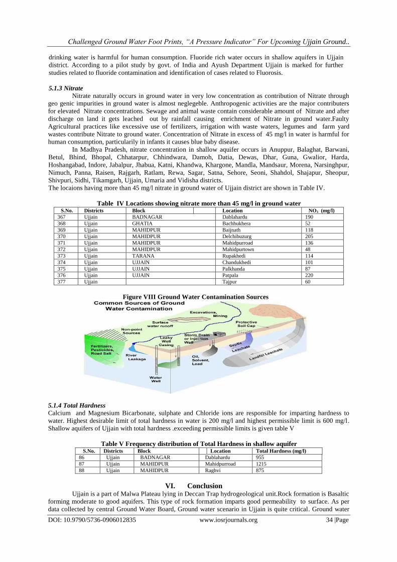
Figure VIII Ground Water Contamination Sources
5.1.4 Total Hardness
Calcium and Magnesium Bicarbonate, sulphate and Chloride ions are responsible for imparting hardness to
water. Highest desirable limit of total hardness in water is 200 mg/l and highest permissible limit is 600 mg/l.
Shallow aquifers of Ujjain with total hardness .exceeding permissible limits is given table V
Table V Frequency distribution of Total Hardness in shallow aquifer S.No. Districts Block Location Total Hardness (mg/l)
86 Ujjain BADNAGAR Dablahardu 955
87 Ujjain MAHIDPUR Mahidpurroad 1215
88 Ujjain MAHIDPUR Raghvi 875
VI. Conclusion Ujjain is a part of Malwa Plateau lying in Deccan Trap hydrogeological unit.Rock formation is Basaltic
forming moderate to good aquifers. This type of rock formation imparts good permeability to surface. As per
data collected by central Ground Water Board, Ground water scenario in Ujjain is quite critical. Ground water
Challenged Ground Water Foot Prints, “A Pressure Indicator” For Upcoming Ujjain Ground..
DOI: 10.9790/5736-0906012835 www.iosrjournals.org 35 |Page
scenario pre and post monsoon for 2014 and January 2015. As well as decadal ground water fluctuations
suggest that ground water level is alarmingly low in Ujjain , despite of the fact that Ujjain enjoys Basaltic
underground rock formation. The other problem confronted is that in Ujjain the equilibrium between Recharge
and discharge of water from aquifer is also disturbed . The main source of recharge of aquifers is natural rainfall
and as per data collected from CGWB in 2014 Ujjain received 20.00% less rainfall with respect to normal .
High quantities of radicals like F and 𝑁𝑂3also point towards unwanted and malafied anthropological activities.
Increase in 𝐶𝑂2 concentration in the atmosphere suppresses precipitation resulting in to drier season and less
rainfall. Routine activities like turning the lights on , cooking food or use of traditional energy sources add up to
carbon footprints by the emission of 𝐶𝑂2and other heat trapping gases. As per official data around 150 Lakh
people have taken dip in the holy Kshipra river. Power was supplied in the fair through high tension center and
33/11 KV subcenter. 45 generators and 23 mobile towers have been installed. Power load of Simhastha area
was 100 MV, while the consumption of whole city is only 110 MV. SimhasthaMela area had more than 100
food zones catering to the dietary needs of 150 Lakh pilgrims. All these factors add up to accumulation of 𝐶𝑂2
in the environment. Simhastha fair could have harnessed solar energy for combating energy needs in the form of
Solar furnaces, Solar lights etc.,but unfortunately not much was done in this field resulting in the increase of
carbon foot prints and worsening the ground water scenario further.
References [1]. CGWB Northern Central Region Dewas District groundwater information booklet, (2007) Bhopal.
[2]. CGWB Northern Central Region Indore District groundwater information booklet, (2009)Bhopal.
[3]. CGWB Northern Central Region Ujjain District groundwater information booklet, (2008) Bhopal. [4]. World Bank Deep Wells and Prudence: Towards Pragmatic Action for Addressing Groundwater Overexploitation in India. World
Bank, (2010) Washington.