Chaffee County - Colorado State Forest Service · 3 BACKGROUND Chaffee County is situated in the...
32
Chaffee County Community Wildfire Protection Plan 2009 May 5, 2009 “When you take a position toward a field of fact or fantasy, you do something strangely like the choosing of a vantage point from which you view a valley….Point of view and perspective determine the special arrangement and design of the entire panorama. Any valley may be seen from a thousand outlooks. Always the same valley, it presents itself in a thousand manners according to the outlook.” – Walter B. Pitkin, as quoted by H.T. Gisborne in “Review of problems and accomplishments in fire control and fire research.” Fire Control Notes , vol. 6, no. 2, April, 1942 The most current version of this plan and supporting documents are available on-line at www.wildfireplan.org.
Transcript of Chaffee County - Colorado State Forest Service · 3 BACKGROUND Chaffee County is situated in the...
Chaffee County Community Wildfire
Protection Plan 2009
May 5, 2009
“When you take a position toward a field of fact or fantasy, you do something strangely like the choosing of a vantage point from which you view a valley….Point of view and perspective determine the special arrangement and design of the entire panorama. Any valley may be seen from a thousand outlooks. Always the same valley, it presents itself in a thousand manners according to the outlook.”
– Walter B. Pitkin, as quoted by H.T. Gisborne in “Review of problems and accomplishments in fire control and fire research.” Fire Control Notes, vol. 6, no. 2, April, 1942
The most current version of this plan and supporting documents are available on-line at www.wildfireplan.org.

2
Mission Statement
The mission of the Chaffee County Community Wildfire Protection Plan is to identify wildfire hazards, prioritize hazards to public safety and community values, and develop
objectives and activities to reduce wildfire risk in the highest priority areas. Introduction
“(B) PRIORITY.—In allocating funding under this paragraph, the Secretary should, to the maximum extent practicable, give priority to communities that have adopted a community wildfire protection plan or have taken proactive measures to encourage willing property owners to reduce fire risk on private property.”[emphasis added]
— Healthy Forests Restoration Act of 2003
The word “proactive” has twice been banished from the English language for “mis-use, over-use, or general uselessness.” (1991 and 1993, Lake Superior State University.) However, Chaffee County probably merits the word’s return from exile for the measures taken since the early 1990’s to reduce wildfire risk. Considering the county’s fairly minimal history of wildfire occurrence and severity, our efforts have been substantial: subdivision pre-attack wildfire plans, public awareness campaigns including FireWise materials, hazard fuel reduction, slash collection and grinding. We have not waited until after the big fire to reduce fire risk.
Regardless, Chaffee County will not receive priority or funding based on a history of “proactive measures.” Recent federal and state legislation, as well as administrative implementation, are requiring a plan. As example, the 2009 Colorado Wildland Urban Interface grant instructions state: “Application must be supported in a Community Wildfire Protection Plan that meets Healthy Forest Restoration Act minimum standards.”
“(3) COMMUNITY WILDFIRE PROTECTION PLAN.—The term ‘‘community wildfire protection plan’’ means a plan for an at-risk community that—
“(A) is developed within the context of the collaborative agreements and the guidance established by the Wildland Fire Leadership Council and agreed to by the applicable local government, local fire department, and State agency responsible for forest management, in consultation with interested parties and the Federal land management agencies managing land in the vicinity of the at-risk community;
“(B) identifies and prioritizes areas for hazardous fuel reduction treatments and recommends the types and methods of treatment on Federal and non-Federal land that will protect 1 or more at-risk communities and essential infrastructure; and
“(C) recommends measures to reduce structural ignitability throughout the at-risk community.”
— Healthy Forests Restoration Act of 2003

3
BACKGROUND
Chaffee County is situated in the center of the State of Colorado, and encompasses approximately 1,014 square miles. It is rural, consisting of mountains (including the Continental Divide along the Western border), canyons, open parks, and forested lands. The county seat is Salida. There are three incorporated towns (Buena Vista, Salida, and Poncha Springs), and several unincorporated towns, including, but not limited to, Centerville, Nathrop, and Maysville. Most residential communities are without formal government, and many summer recreation homes are located throughout the County. Chaffee County is divided into two fire protection districts, with 3 fire departments.
The County’s major transportation infrastructure involves three U.S. highways: Highway 50 running from Big Horn Sheep Canyon through Salida to the summit of Monarch Pass; Highway 285, one of the major routes into the mountains from the Denver metro area; and Highway 24, the major route from the Colorado Springs area into the mountains.
Since the 1990s, Chaffee County’s population has expanded at an ever-increasing rate. According to 2006 census data, the population is approximately 16,918. Most of the growth is in unincorporated forested areas. Population projections indicate that by 2035, the population of Chaffee County will reach 28,930. As our population expands, so does the potential of wildfire to destroy homes communities. Important values such as watersheds, scenic vistas and recreation areas are also threatened.
A natural border north of Buena Vista divides the San Isabel National Forest in Chaffee County between two ranger districts that share fire management staff. The dividing line is marked by Mt. Harvard, Mt. Columbia and Elephant Rock. The Leadville Ranger District includes the drainages for Powell, Three Elk, Four Elk, Frenchman, and Pine Creek. The Salida Ranger District takes in the drainages for Horn Fork, North Cottonwood and Fourmile Creek. The Mountain Zone Fire Management Office in Poncha Springs serves both ranger districts.
The Royal Gorge Field Office in Canon City manages 54,985 acres of Bureau of Land Management lands in Chaffee County.
The Salida District Office of the Colorado State Forest Service covers both Chaffee County and Lake County.
Discussion of Fire plans
• Upper Arkansas Valley Wildfire Annual Operating Plan, includes Chaffee and Lake Counties.

4
• Within the 2004 BLM Fire Management Plan, Chaffee County is managed as part of the Upper Arkansas Fire Management Unit, which also includes Lake County.
• The PSICC 2008 Fire Management Plan splits Chaffee County between two fire management units: the land south of U.S. Highway 50 and east of U.S. Highway 285 is in the Lower Arkansas Fire Management Unit, which also includes Costilla, Custer, Fremont, Huerfano, Las Animas, and Pueblo counties. The remainder of Chaffee County is in Upper Arkansas Fire Management Unit with Lake and portion of Park County
Wildland Urban Interface (WUI) Description According to the guide, Preparing a Community Wildfire Protection Plan: A Handbook for Wildland-Urban Interface Communities, “The wildland-urban interface (WUI) is commonly described as the zone where structures and other human development meet and intermingle with undeveloped wildland or vegetative fuels.” One of the benefits of a CWPP, under the HFRA, is the opportunity to establish a localized definition and boundary for the wildland urban interface. A minimum of fifty percent of all funds appropriated for projects under the HFRA must be used within the WUI as defined by the CWPP, or by the limited definition (one-half mile or up to one and one-half miles with mitigating circumstances) of community boundaries. HFRA also gives priority to projects and treatments on federal public lands that occur within an area defined or identified in a CWPP. Most of the factors and treatments that determine the survivability of a structure lie within one to two hundred yards of the structure, and usually it is located on private lands. However, many other items beyond that distance are critical to a community. These include, among others, community water supplies, effects on property and real estate values, community infrastructure, economic impacts to residents and businesses, aesthetic values, and a sense of community or why “we live here.” Because of those factors, it is important for this CWPP to define a WUI that includes all items critical to the communities. In addition, the WUI will also be identified as all lands within two miles of all the subdivisions identified in the table in the Appendix and all identified towns or communities not part of the subdivision list, including Salida, Poncha Springs, Centerville, Nathrop, and Buena Vista. It also includes a half mile area along each side of all evacuation routes for all of the above identified subdivisions and towns. The WUI will also include all designated town or municipal watersheds if located outside of the above defined areas. It is, in addition, defined as a two-mile buffer around all water development and storage structures.

5
6
1. GOALS AND OBJECTIVES Chaffee County experiences frequent high winds, dry conditions, lightning storms, and heavy use of wildlands by residents and visitors alike, which can all lead to destructive wildfires. The fire does not have to be very large to cause significant damage. This countywide plan is intended as a first step in the wildfire mitigation planning process. The following are the broad goals and specific objectives of the Chaffee County Community Wildfire Protection Plan: Planning and Collaboration Goal: Create a “living” flexible document that incorporates a multi-agency approach to planning. The CWPP incorporates input from all the stakeholders in the County. These include the local citizens, representatives from selected subdivisions, the two Fire Protection Districts, as well as the Federal Land Management Agencies (US Forest Service and Bureau of Land Management), the Colorado State Forest Service, and Chaffee County Government, Emergency Services, and Sheriff’s Office. This collaboration will provide a multi-jurisdictional approach to strategic planning, and improve fire suppression and fuel treatment efficiencies on public and private lands. It is an “umbrella plan,” encouraging local subdivisions or communities to create their own site specific CWPP. Specific objectives
1. Review the CWPP every two years and make changes as needed through consensus building process within the coalition.
2. Evaluate the identified priority list at a minimum of every five years, to ensure currency. 3. Conduct quarterly meetings to monitor changing circumstances, review progress, and
update the plan by adding any new subdivisions or landowners. Public Safety and Awareness Goal: Promote and develop materials and programs in prevention and education that improve community wildfire awareness and safety. The CWPP provides a forum for the coordination of public meetings, discussion groups, and public information campaigns to create awareness within Chaffee County about wildfire danger

7
and to create action to mitigate hazards on both public and private lands, and improve prevention and preparedness. Specific objectives
1. Develop an initial assessment of subdivision risk to catastrophic wildfire and preparedness for wildfire. Present the assessment to the residents of Chaffee County through this CWPP.
2. Within three months of plan approval, create a link to the Chaffee County website
providing public access to coalition progress, and information for developing local community wildfire protection plans in their own neighborhood.
3. Within three months of plan approval, distribute copies of the CWPP and reference
materials to libraries, post offices, and fire stations. 4. Promote the involvement of communities and or landowners to become a part of the
Chaffee County CWPP by attending association meetings and public workshops as requested.
5. Provide information to individuals and homeowners associations for creating defensible
space and reducing the susceptibility of structures to wildfire by identifying websites and other sources in this document.
Fuels Reduction Goal: Facilitate appropriate hazardous fuel reduction by illustrating the areas of greatest wildfire hazard and developing the highest priorities for fuels abatement treatments. The CWPP displays the relative levels of wildfire hazard in the County, both private and public, and selects the highest priority areas for land management agencies to focus their fuels treatment activities on public lands. Also, the identification of the highest areas of concern will improve multi-jurisdictional pre-suppression planning and facilitate the implementation of cross boundary projects. Specific objectives
1. Develop an initial county-wide assessment of wildfire hazard on both public and private lands, and display that assessment in this document.
2. Provide a list of the three highest priority areas within Chaffee County, to public land
manager and to the public. The goal will be to focus on these high priority areas for fuel treatment projects, reducing the wildland fire danger, and protecting life and property. Display those priorities in this document.
8
3. Hold 3 to 5 public meetings/year to gather input from the stakeholders that are in the high priority areas. At the meetings identify action items for work to be done on private, state or federal lands. In addition, provide justification for those action items. Identify a point of contact or representative for a community that wants work done.
4. Revaluate those priorities, at least every 5 years, or as project planning and
implementation are completed on the private and public lands. 5. Provide support, through the coalition, to create cooperative efforts across jurisdictional
or ownership boundaries on an ongoing basis as requested.
2. CURRENT RISK SITUATION Drought Colorado is a state with a semi-arid climate. Average annual precipitation for much of Chaffee County is ten to twelve inches. Precipitation increases with increasing elevation, but most of the highest elevations are still less than 20 inches annually, except along the Continental Divide, which may see as much as 30 inches. Colorado has a long history of periods of low precipitation and drought, including our most recent years. The period from the beginning of the 1980’s to approximately the late 1990’s was actually one of the wettest periods in Colorado history, and hence, is a deceptive indicator of long-term moisture regimes. Throughout history, drought is more the norm in the arid Inter-mountain West. One of the short-term effects of drought and water shortage is an increased risk for wildfires. Prolonged weather patterns, such as drought, correlate strongly to major fire years in Chaffee County. For example, the Hayman fire occurred during the spring of 2002, which was the driest on record for Colorado at the time. There were 15,770 fires in the Rocky Mountain Region that year. 2003 saw higher precipitation and a lower incidence of wildfires, with a total of 3,957 fires. Changing Fuel Conditions Fuel types in Chaffee County range from open grasslands to lodgepole pine in the higher elevations, and ponderosa pine, Douglas-fir, pinion, and juniper in other portions of the County. Within all of these fuel types are patches of aspen and cottonwood. Natural fire regimes differ in all these fuel types, and, therefore, so do the strategies to mitigate wildfire hazard. Over the years, many of our forests, primarily in the mid elevation zone of ponderosa pine and Douglas fir, have become overpopulated, more susceptible to insect and disease mortality, and have accumulated greater levels of surface fuels. Before fire suppression, this forest type was characterized by frequent, low intensity fires. Most stands burned every five to thirty years. Frequent burning had a thinning and cleansing function in this forest type. Stands maintained in this way were open, with an herbaceous groundcover. There were significantly fewer, but larger, ponderosa pines since the larger trees with their thick bark were able to withstand the heat of the ground fires. In the open canopy of the ponderosa forests, large crown fires were rare events
9
since fires were not able to move through the open canopy. The most devastating crown fires over the last decade have been in this forest type. The result is a change in the species composition. For example, the proportion of Douglas fir has increased significantly due to the denser, more closed forests. Douglas fir does not regenerate well in the open canopy. Regeneration of Douglas fir further increases forest density and creates abundant ladder fuels to move fires into the treetops. The natural fire process of lodgepole pine forest is quite different. Large fires are the norm in this forest type. These fires created openings of various sizes, which quickly sprouted with new seedlings. Overstocked, unmanaged tree stands that have not had frequent natural low intensity fires will often fuel large, catastrophic fires that threaten lives, property and environment. The aftermath of such incidents leaves the forest void of nutrients, a clean water supply, and a home for displaced wildlife. In forests that are not overstocked, wildfire burns more slowly and often stays closer to the ground, clearing away excess fuel and revitalizing the forest, without destroying the healthy trees. Increased mortality and lack of low intensity fires, combined with very low decomposition rates in an arid climate, adds more dead wood to the surface of the forest. Grass fires can be destructive fires that spread rapidly, threatening structures and communities. Land use practices, such as roads, grazing and irrigation, have reduced the intensity of grass fires. Much of the higher elevation forests are reaching the end of typical fire free cycles. There is no quick fix for the current situation we find ourselves in. It has taken almost a century to create the problem and it will take that long to correct it. Forest Insect and Disease Conditions Insect and disease outbreaks have several impacts on potential wildfires. First, standing dead, with their dead needles still intact, add considerably to the potential for crown fires, as well as significantly increasing the spread rates of crown fires. The small dead needles act much like kindling, spreading fire to the larger diameter wood. Without the needles the fire will not often spread through the crowns. Once the needles have fallen, dead trees may actually reduce the potential for crown fires or reduce fire spread. Regardless, as snags catch fire and fall, dead trees increase hazard to firefighters. As fire burns up the trunk of dead trees, embers are carried into the air increasing the danger of new fires igniting downwind. In the absence of fire, over time the snags begin to blow down. The downfall greatly increases the surface fuel load, and the likelihood of mortality or crown fire in the remaining forest. The heat from large accumulations of fuel adds significantly to soil damage as heavy fuels burn for long periods of time. This unraveling of the forest as mortality occurs and trees start to fall is what makes many high elevation forest types flammable.

10
Control strategies for these or any other forest insects or diseases are complex and site specific, and beyond the scope of this document. Forestry advice is available to landowners through the Colorado State Forest Service, consulting foresters, and the Colorado State University Cooperative Extension Service. Information on forest insects and disease and fire mitigation can be obtained from the Colorado State Forest Service Website at: http://csfs.colostate.edu To view aerial maps of insect activity in Chaffee County, go to: http://www.fs.fed.us/r2/resources/fhm/aerialsurvey/.
3. WILDLAND FIRE BEHAVIOR AND CHAFFEE COUNTY FIRE SEASONS Fire behavior Fire behavior is a science that attempts to account for the interacting forces that make fire such a dynamic feature of the natural environment. The fire behavior triangle shows the primary factors that influence how a wildland fire will burn and spread. They are fuels, topography and weather. When specific characteristics of each of these factors are known, the behavior of a fire can be predicted, and the way it will burn on the landscape can be modeled.
Figure 1: Fire Behavior Triangle
FUELS Primary forest fuels consist of grass, herbs, and other non-woody vegetation, downed woody material, shrubs and brush, conifer trees, duff (decaying material) and litter on the forest floor. Heavy surface fuels, such as shrubs and small trees or dense accumulations of down wood, or conifer trees with low branches, can create fuel “ladders” to carry fire from the surface to the crowns of conifer trees. Torching is when individual trees, or small groups of trees, have burning crowns. If the trees are dense enough, and winds are high enough or the slope steep enough, flames at the top of the

11
larger trees will spread to other trees. This is called a “crown fire,” and it can spread rapidly, given the right conditions. Fires also commonly “spot,” when embers carried by air currents ahead of, or adjacent to, the fire and cause spotting. The embers may ignite new fires and rapidly increase the rate of spread and difficulty of control. Spotting can range from tiny embers landing close to the existing fire, to larger burning material, such as pine cones or small branches, being lofted high in the air and landing up to a mile or more ahead of the fire. Fires in grass tend to move with amazing speed during high winds. The risk to life and property is greatest where grasses are taller, and the most effective mitigation strategy in grass fuel types is to mow or graze the grass to keep the height low. Aspen must also be mentioned in any discussion of fuels. Any mitigation activities that enlarge or regenerate aspen patches will have multiple benefits. Aspen are often the first species to regenerate after a fire, and provide important food for deer and elk. Deciduous trees, such as aspen, do not support crown fires and are a natural fuel break. One of the most significant effects of fire suppression has been diminished numbers of aspen. There are relatively few large stands of aspen in the county, but there are many small stands scattered throughout the other fuel types. TOPOGRAPHY Topography is the “lay of the land”. Critical factors that influence fire behavior are slope steepness and direction, also known as aspect. Fire will spread at a much higher rate uphill because the convective heat rising from the fire is preheating and drying the fuels ahead of the fire. Aspect is the direction in which the slope faces. Usually lighter, faster burning fuels occur on south and west slopes, which are drier and receive the most sun. North and east facing slopes are cooler and more moist, resulting in more dense vegetation. In the lower altitudes of the County, south and west slopes are usually open ponderosa forests, while north and east slopes consist of dense stands of ponderosa and Douglas fir. Aspect can also increase the effects of wind, or shelter the fire from wind. A critical combination that may increase fire intensity is when slopes are aligned with the wind and the sun, such as on southwest slopes in the afternoon. Special features, like drainages, saddles, and canyons, funnel wind and the heat of the fire and produce much higher intensities and spread rates. Many firefighter fatalities have occurred in these features. Weather Weather is the leg of the fire behavior triangle that will always remain uncontrollable and sometimes, unpredictable. Unlike fuels, which can be managed, and topography, which remains fixed, weather is a dynamic force that can quickly change a small ground fire into a roaring crown fire.
12
Another factor in fire behavior is air and fuel temperature. High air temperatures reduce the amount of pre-heating necessary to bring fuels to the temperature of ignition. Bright sunshine can raise the surface temperature of ground fuels to 150°F, much higher than the temperature of surrounding air. When air temperature rises, relative humidity falls. Humidity quickly affects the lighter fuels that are critical for carrying fires. Smaller fuels dry or absorb moisture more quickly that large diameter fuels. When humidity decreases, smaller fuels will dry quickly, and ignite more easily. Weather patterns change rapidly, often making wildfires difficult to control. Fire behavior can be relatively accurately predicted when one has knowledge of the fuels, fuel moistures, predicted weather, and the terrain on which the fire is burning in. However, interaction of the various fire triangle elements, spotting, and high intensity fires can result in behavior that can catch both firefighters and residents unaware, if they don’t plan for all contingencies.
Fire Seasons Chaffee County has a wide range of elevations and topography that influence where and when fires burn. The majority of the fire activity occurs in the lower to middle elevations, which is comprised mostly of ponderosa pine and Douglas fir. Weather is dominated by lesser snow amounts, which often melt after storms and a wet July and August monsoon season. Although fires can occur year round here, there are three typical periods when high fire danger can occur. The first is spring after snowmelt, when the grass has not greened up, shrubs have not leafed out, and fuel moistures in the conifers are low. Strong winds are common. The next and typically highest period of fire danger is late May through early July before the onset of the monsoon season, when fuel moistures are still low, lightning has started, air temperatures are high, humidity is low, high winds are common, and burning periods (daylight) are at their longest. The monsoon season is the period of the greatest number of fires, because of the extensive thunderstorms and lightning. If the storms have rain, there is usually less potential for large fires and most fire spread is extremely slow, if at all. However, if the storms produce a dry lightning event, where there is little or no rain, the potential for wildfires can be very high to extreme. Finally, in the fall after the monsoon season, there can be periods of higher fire danger with the return of drier conditions, dormancy of vegetation, and winds. Even though there is potential, no large fires have occurred in Chaffee County during this time period over the last several decades. The higher elevations, especially the northern and northwest part of Chaffee County, consist of subalpine (lodgepole pine, spruce, bristle cone pine, etc) or alpine (tundra above tree line) vegetation. These areas have a low fire occurrence in most years. Typically, the monsoons start shortly after snowmelt, and fuels rarely have time to dry out significantly. Temperatures are lower and humidities higher at these greater elevations. The greatest potential for large fires for these locations are drought years with low snowfall, late or limited monsoons, or worse, both. However, these conditions have not occurred very often.

13
Fire Occurrence Over 770 fires have occurred on National Forest and BLM lands in Chaffee County over the last 30 years, or an average of 25 per year. While lightening is responsible for the majority of the fire starts, the largest and most damaging fires are human caused. Education is critical to prevent the most dangerous types of wildfires.
4. COMMUNITIES PREPAREDNESS TO RESPOND TO WILDLAND FIRES The United States Forest Service is responsible for wildland fire suppression efforts on all federal lands in Chaffee County; these lands include Bureau of Land Management, US Fish and Wildlife and US Forest Service lands. The nearest Forest Service fire engine is located in Poncha Springs. It is a type 6 engine with a minimum of two personnel and a 250 gallon water capacity. Under the Annual Wildfire Operating Plan for Chaffee and Lake Counties, Chaffee County provides mutual aid assistance for wildland fire on federal land. Salida Fire Department/South Arkansas Fire Protection District is responsible for wildland fire suppression efforts around the area of Salida and down river into parts of Fremont County. Salida/South Ark maintains a daily staff of 3 fire fighters and 1 fire chief and has non-paid reserves for additional personnel. A typical response for Salida/South Ark is a Type 6 or Type 1 engine and a Tender. Buena Vista Fire Department is responsible for wildland fire suppression efforts around the area of the Town of Buena Vista. It is an all volunteer fire department. Chaffee County Fire Protection District (CCFPD) covers the remaining area for the County. CCFPD has a full-time paid chief and administrative staff. The fire fighters are all volunteers. CCFPD currently has 4 stations located throughout the County and is building a new station in Maysville. Station #1 is located in Buena Vista, Station #2 is located in Nathrop, Station #3 is located at the far north end of the County, and Station #4 is located in Poncha Springs. CCFPD has several apparatus located at the stations and throughout the County that respond to wildland fires. In the event that a wildland fire goes beyond the capability of the local resources additional resources can be ordered through the interagency dispatch center located in Pueblo.
5. COMMUNITY ASSESSMENT STRATEGIES Methods Most of the factors and treatments that determine the survivability of a structure lie within one to two hundred yards of the structure, and usually it is located on private lands. Public land managers do not have any legal authority or responsibility for fire mitigation on those private lands. Likewise, the fire districts do not have mandated responsibility for preparing private property for fire safety. Therefore, the largest opportunity to decrease risk from wildfire lies with the private property owners acting individually or as a community.

14
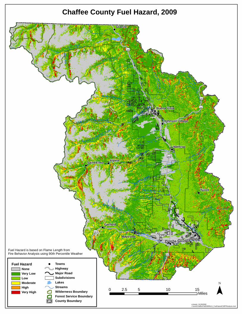
The wildfire risk to the community involves many exposures. Among these are water supplies, natural resources, land values, critical infrastructures (such as highways and bridges which can be affected by fire), and even a sense of community. The responsibility for mitigating risk to these critical values crosses all jurisdictional boundaries, including public lands, which make up a large portion of Chaffee County. Risk from wildfires can be viewed at the individual home, structure, or other development level, whether it is public or private. The bigger picture of evaluating risk is at the community level and beyond. Thus, two methods of assessment were done. HFRA, as discussed earlier, requires CWPPs to identify and prioritize fuel reduction treatment areas, and recommend measures homeowners and communities can take to reduce the ignitibility of structures. The first is an overall assessment of all lands in Chaffee County. This is the bigger picture of community risk, which provides the information necessary to identify and prioritize fuels treatment areas. The treatment includes both public and private lands. The second is an evaluation of individual subdivisions, and is a more specific assessment of risk to homes and developments. This assessment of potential for catastrophic fire and preparedness is also the first step in meeting the goal, identified by HFRA, of reducing the ignitibility of structures. It is also important to understand that the subdivision assessment was purposely done at a broad, strategic level. The results were not intended to be absolute at the lot size or small acreages. Communities should expect to do more site-specific analysis as it relates to their lot or acreage, through a neighborhood wildfire protection plan. The key element of the CWPP assessment was to utilize objective, quantifiable data that already existed or could be relatively easily collected (subdivision surveys). This data was then incorporated in a table and mapped for the subdivision assessments. A Geographic Information System (GIS) analysis was used for the overall lands assessment. For more information on how to protect your home and property please go to http://www.firewise.org. Overall Lands Assessment The standard methodology for assessing overall wildland fire hazard consists of analyzing at least three core inputs: fuels hazard, ignition risk, and values at risk. All these factors can, then, be combined into one overall wildfire risk rating. Fuels Hazard Fuels hazard is based on the type of fire behavior that could result if a fire occurs and spreads in the vegetation type or “fuel bed” that exists at a given location. This is done by the use of “fuel models” which are mathematical representations of various vegetation types with fuel moisture, weather, and topographical variables or inputs. The modeling program mathematically calculates the expected behavior of a wildfire. The important information calculated by the modeling program is flame length (the amount of heat produced or fire intensity), rate of spread (how fast it moves), and what type of general fire behavior would occur (surface fire only, surface fire with torching, or crown fire).
15
Flame length of fire intensity is especially critical, because it indicates the difficulty in controlling a wildfire. Higher flame length means a fire produces more heat. Hand crews working directly next to the fire can safely fight flame lengths of four feet or less. When flame length exceeds four feet, fires must be fought by machinery (dozers, air tankers, etc.) a safe distance away from the actual flames. Crews, engines, dozers, and even aircraft may be ineffective against high intensity fires. Weather data utilized in these models represents actual weather collected over decades from local fire weather stations. The data represents weather that is typical on summer days when the fire danger is “high” or “very high.” It is not meant to represent the worst conditions, such as extended drought years like 2002.
16
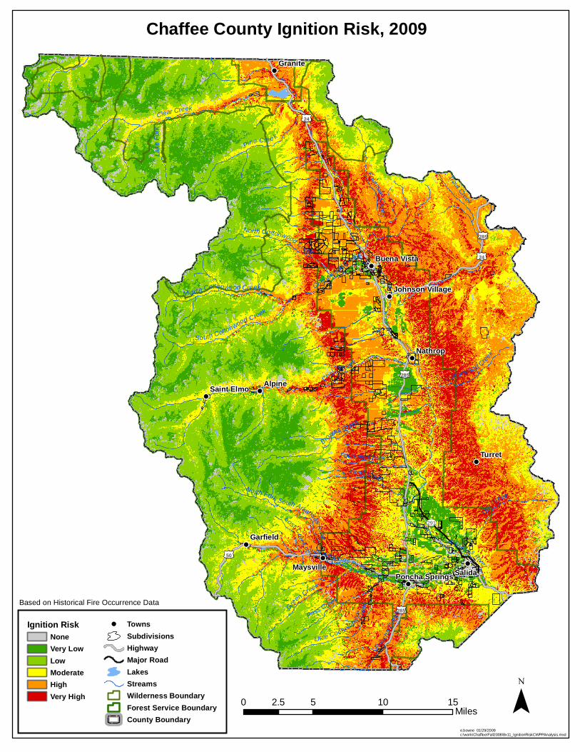
Ignition Hazard Ignition hazard measures the likelihood of fire starting in an area. There are many factors that control this issue, such as vegetation type, lightning, weather patterns, amount of human activities, recreational use, and others. The key to obtaining reliable results is to use quantifiable, available data. The overall indicator of potential ignition hazard is past fire occurrence. Therefore, this CWPP uses fire occurrence from the past 30 years. Changing trends, such as greater human caused fires because of increasing recreational use and residential development, may not be represented just by historical data. However, it is difficult to find reliable data, which can easily be mapped, to characterize any of these trends. Values At Risk The final category for assessing wildfire hazard is an assessment of the values at risk, should a fire occur at a given location. A greater hazard is indicated in areas where values such as homes, critical watersheds, or other items important to the community would be threatened by a fire. A critical part of this process was to determine what is important to residents and communities of Chaffee County. A Critical Values Assessment was conducted as part of the CWPP development process. This was accomplished by conducting a Critical Values Survey in the fall of 2007, asking residents of Chaffee County to rate various values to determine what is most important to them. According to this survey, the priorities were as follows:
1. Population Density 2. Subdivisions 3. Watersheds 4. Economic Resources 5. Historical/Cultural Resources 6. Endangered Species 7. Utilities 8. Recreation Areas 9. Travel Corridors 10. View Shed/ Aesthetics
While all of these ten values are important, this assessment included only the top three when determining priorities for this plan, as those three were by far the most important to residents surveyed. Due to the most recent data available, the density of structures was used to represent the values of homes, infrastructure, population, and other important development. Municipal watersheds and forested watersheds on steep slopes (areas that would be highly susceptible to severe erosion into water courses if a severe fire occurred) represent the watershed values.
17
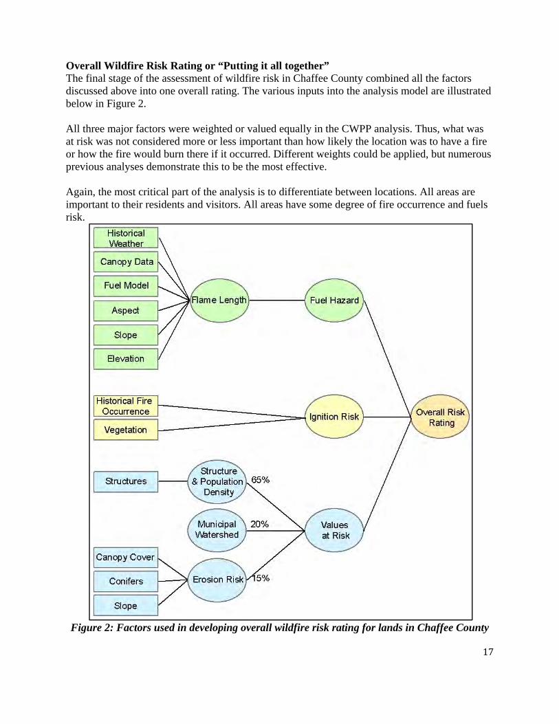
Overall Wildfire Risk Rating or “Putting it all together” The final stage of the assessment of wildfire risk in Chaffee County combined all the factors discussed above into one overall rating. The various inputs into the analysis model are illustrated below in Figure 2. All three major factors were weighted or valued equally in the CWPP analysis. Thus, what was at risk was not considered more or less important than how likely the location was to have a fire or how the fire would burn there if it occurred. Different weights could be applied, but numerous previous analyses demonstrate this to be the most effective. Again, the most critical part of the analysis is to differentiate between locations. All areas are important to their residents and visitors. All areas have some degree of fire occurrence and fuels risk.
Figure 2: Factors used in developing overall wildfire risk rating for lands in Chaffee County
Chalk C reek
24
50
285
285
24
285
291
Clear Creek
Browns Creek
South Arkansas River
Ute
Creek
Arkansas River
Pine Cree k
Sand Creek
Green Creek
Ponch
a Cree
kPass Creek
Fourmile Creek
Little Cochetopa Creek
Trout Creek
South Cottonwood C reek
North Cottonwood Creek
Cottonwood Creek
Middle Cottonwood CreekLost Creek
Lake
Fork
North Fork South Arkansas River
Fourmile Cr eek
Cottonwood Creek
Salida
Alpine
Turret
Nathrop
Granite
Garfield
Maysville
Saint Elmo
Buena Vista
Poncha Springs
Johnson Village
Chaffee County Fuel Hazard, 2009
Fuel HazardNoneVery LowLowModerateHighVery High
TownsHighwayMajor RoadSubdivisionsLakesStreamsWilderness BoundaryForest Service BoundaryCounty Boundary
e.bowne 01/29/2009c:\work\Chaffee\Fall2008\8x11_FuelHazardCWPPAnalysis.mxd
0 5 10 152.5Miles
Fuel Hazard is based on Flame Length from Fire Behavior Analysis using 90th Percentile Weather
Chalk C reek
24
50
285
285
24
285
291
Clear Creek
Browns Creek
South Arkansas River
Ute
Creek
Arkansas River
Pine Cree k
Sand Creek
Green Creek
Ponch
a Cree
kPass Creek
Fourmile Creek
Little Cochetopa Creek
Trout Creek
South Cottonwood C reek
North Cottonwood Creek
Cottonwood Creek
Middle Cottonwood CreekLost Creek
Lake
Fork
North Fork South Arkansas River
Fourmile Cr eek
Cottonwood Creek
Salida
Alpine
Turret
Nathrop
Granite
Garfield
Maysville
Saint Elmo
Buena Vista
Poncha Springs
Johnson Village
Chaffee County Ignition Risk, 2009
e.bowne 01/29/2009c:\work\Chaffee\Fall2008\8x11_IgnitionRiskCWPPAnalysis.mxd
Based on Historical Fire Occurrence Data
Ignition RiskNoneVery LowLowModerateHighVery High
TownsSubdivisionsHighwayMajor RoadLakesStreamsWilderness BoundaryForest Service BoundaryCounty Boundary
0 5 10 152.5Miles

Chalk C reek
24
50
285
285
24
285
291
Clear Creek
Browns Creek
South Arkansas River
Ute
Creek
Arkansas River
Pine Cree k
Sand Creek
Green Creek
Ponch
a Cree
kPass Creek
Fourmile Creek
Little Cochetopa Creek
Trout Creek
South Cottonwood C reek
North Cottonwood Creek
Cottonwood Creek
Middle Cottonwood CreekLost Creek
Lake
Fork
North Fork South Arkansas River
Fourmile Cr eek
Cottonwood Creek
Salida
Alpine
Turret
Nathrop
Granite
Garfield
Maysville
Saint Elmo
Buena Vista
Poncha Springs
Johnson Village
Chaffee County Values at Risk, 2009
Values at RiskVery LowLowModerateHighVery High
TownsHighwayMajor RoadSubdivisionsLakesStreamsWilderness BoundaryForest Service BoundaryCounty Boundary
e.bowne 01/29/2009c:\work\Chaffee\Fall2008\8x11_ValuesAtRiskCWPPAnalysis.mxd
0 5 10 152.5Miles
Values at Risk = Population/Structure Density 65%, Municipal Watersheds 20%, Erosion Hazard 15%
Chalk C reek
24
50
285
285
24
285
291
Clear Creek
Browns Creek
South Arkansas River
Ute
Creek
Arkansas River
Pine Cree k
Sand Creek
Green Creek
Ponch
a Cree
kPass Creek
Fourmile Creek
Little Cochetopa Creek
Trout Creek
South Cottonwood C reek
North Cottonwood Creek
Cottonwood Creek
Middle Cottonwood CreekLost Creek
Lake
Fork
North Fork South Arkansas River
Fourmile Cr eek
Cottonwood Creek
Salida
Alpine
Turret
Nathrop
Granite
Garfield
Maysville
Saint Elmo
Buena Vista
Poncha Springs
Johnson Village
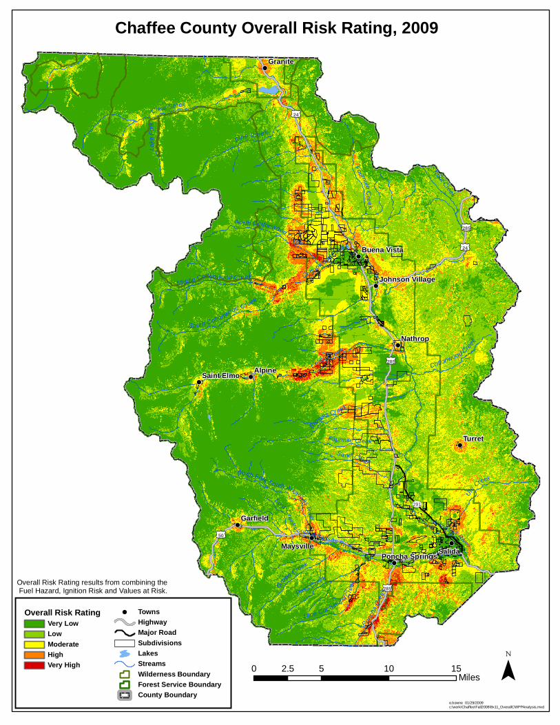
Chaffee County Overall Risk Rating, 2009
Overall Risk RatingVery LowLowModerateHighVery High
TownsHighwayMajor RoadSubdivisionsLakesStreamsWilderness BoundaryForest Service BoundaryCounty Boundary
e.bowne 01/29/2009c:\work\Chaffee\Fall2008\8x11_OverallCWPPAnalysis.mxd
Overall Risk Rating results from combining the Fuel Hazard, Ignition Risk and Values at Risk.
0 5 10 152.5Miles

22
The wildfire risk rating maps present a broad, strategic look at wildfire risk in Chaffee County. The data used was not intended to provide exact information for site-specific project implementation, but rather identification of areas with the highest relative exposures when planning projects. This depiction is a useful tool to prioritize locations for fuels mitigation or other work on private lands. It also enables Chaffee County to display its highest priorities for Federal land managers for fuels mitigation projects on public lands. Subdivision Assessment As previously stated, most of the mitigation work to protect individual homes or structures will occur on private lands. Firefighters from Chaffee County Fire Protection District and Salida/South Arkansas Fire Protection District assessed each subdivision in the county during 2007 and 2008. The assessment displays which subdivisions may be at highest risk from a damaging fire, and which have factors that are not conducive to successful fire suppression and structure defense. These are ratings for the subdivision as a whole. They are not meant to be indicative of individual homes or lots. Fire professionals used averages for the overall subdivision ratings. The rating for Catastrophic Wildfire Risk was based on the following factors:
• Vegetation – fuels and density • Topography – slope steepness • Subdivision Design – lot size
Of these factors, usually only the type and quantity of vegetation can be changed by property owners. The factors used for rating the preparedness of a subdivision and the resulting risk to property are: Subdivision Design
• Ingress/Egress • Primary road widths • Accessibility • Dead ends (secondary road terminus) • Presence of street signs • Vegetation • Defensible spaces created
Structure Design • Materials
Fire Protection
• Response time • Hydrants • Draft sources (locations where fire engines can draft water into the engine if hydrants or
pump sites don’t exist) Utilities
• Utilities – Placement above or below ground
23
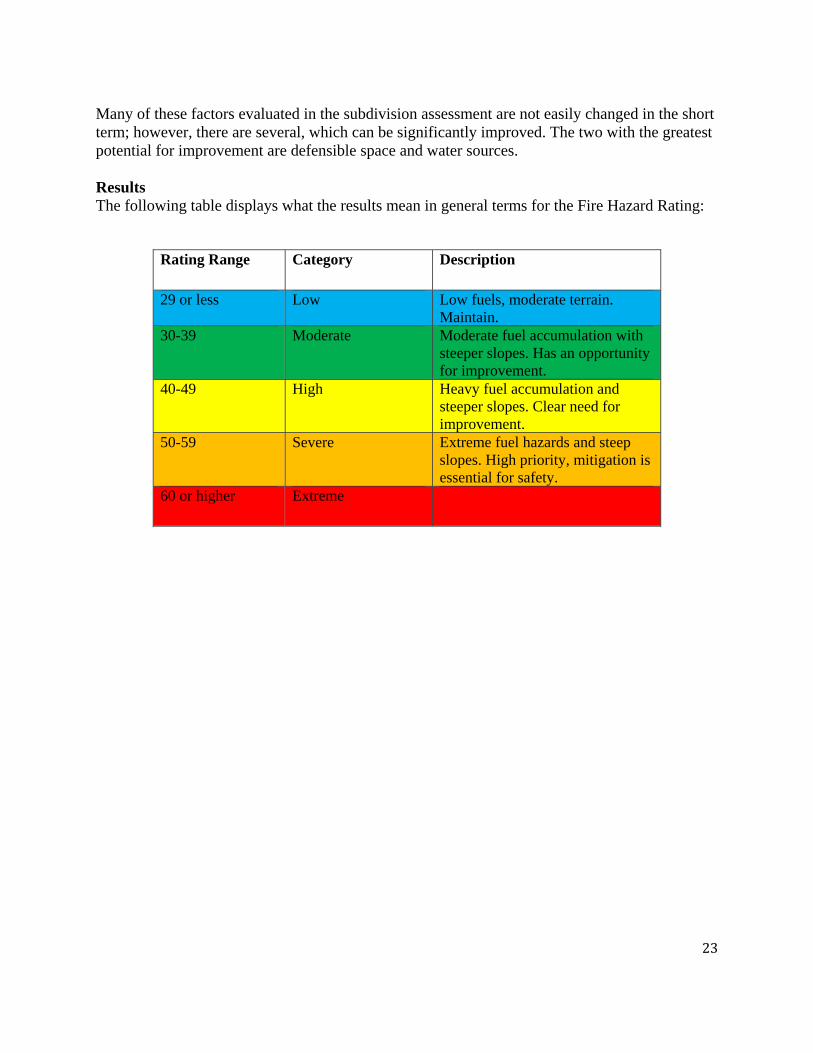
Many of these factors evaluated in the subdivision assessment are not easily changed in the short term; however, there are several, which can be significantly improved. The two with the greatest potential for improvement are defensible space and water sources. Results The following table displays what the results mean in general terms for the Fire Hazard Rating:
Rating Range Category Description
29 or less Low Low fuels, moderate terrain. Maintain.
30-39 Moderate Moderate fuel accumulation with steeper slopes. Has an opportunity for improvement.
40-49 High Heavy fuel accumulation and steeper slopes. Clear need for improvement.
50-59 Severe Extreme fuel hazards and steep slopes. High priority, mitigation is essential for safety.
60 or higher Extreme

24
2007‐2008 Risk Assessment Subdivision, Community,
or Neighborhood Fire
District RiskRating
Hazard Class
Eagles Roost CCFPD 87 Extreme Angel Of Shavano CCFPD 75 Extreme Jo Love Ranch CCFPD 67 Extreme Mt. Princeton Hot Springs CCFPD 62 Extreme Rancho Antero Estates CCFPD 62 Extreme Silver Cliff Club CCFPD 62 Extreme Princeton Shadows CCFPD 62 Extreme Milne Subdivision CCFPD 62 Extreme Deer Valley Ranch CCFPD 62 Extreme Chalk Creek Acres CCFPD 62 Extreme Chalk Creek Estates CCFPD 62 Extreme Alpine CCFPD 60 Extreme
Lost Creek Ranch CCFPD 58 Severe Trail West Village CCFPD 58 Severe Meadow Lake Mtn Estates CCFPD 55 Severe North Fork Acres CCFPD 53 Severe Mesa Antero Estates CCFPD 50 Severe St. Elmo CCFPD 50 Severe
Whispering Pines CCFPD 47 High Trout Creek Meadows CCFPD 47 High Cochetopa Estates CCFPD 46 High The Canyons Rosi CCFPD 46 High Hidden Hills CCFPD 45 High Eureka Ranch CCFPD 45 High Methodist Meadow SAFPD 45 High Methodist Mountain SAFPD 44 High Wapiti CCFPD 43 High Four Elk Camp CCFPD 43 High Mt Harvard Addition CCFPD 43 High Mt Harvard Valley Estates CCFPD 43 High Mt Princeton View Estates CCFPD 40 High
Game Trail CCFPD 39 Moderate Pinon Acres CCFPD 38 Moderate Saddle Ridge Ranch CCFPD 37 Moderate Weldon Creek CCFPD 36 Moderate

25
Tenderfoot Business Park SAFPD 36 Moderate Cedar Gate Estates CCFPD 35 Moderate Maysville CCFPD 34 Moderate Maysville Meadows CCFPD 34 Moderate Boot Hill SAFPD 34 Moderate Mesa Antero CCFPD 32 Moderate Nicholas Hills SAFPD 32 Moderate Pinon Hills SAFPD 30 Moderate
Ute Heights SAFPD 29 Low Webb Tracts SAFPD 29 Low Fawn Ridge SAFPD 27 Low Betty’s Meadows SAFPD 26 Low Hacienda Village CCFPD 26 Low Shikoba Acres SAFPD 26 Low Hilton Subdivision SAFPD 25 Low Mt. Princeton View Estates CCFPD 25 Low Rancho Sawatch CCFPD 25 Low Martha's Court CCFPD 24 Low Rancho Caballeros SAFPD 24 Low The Reserve At Cottonwood Creek CCFPD 24 Low Pikul Subdivision CCFPD 23 Low River West SAFPD 23 Low Carpenter Industrial Air Park CCFPD 22 Low Chaparral SAFPD 22 Low Oro Vista CCFPD 22 Low Shavano Vista SAFPD 22 Low Vista Grande SAFPD 22 Low Windance SAFPD 22 Low Embry Estates (industrial) SAFPD 21 Low Pinon Pines CCFPD 21 Low Rainbow Ridge SAFPD 21 Low Cielo Vista CCFPD 20 Low Meadowlark Estates SAFPD 20 Low The Range ROSI SAFPD 20 Low Troy Kelly CCFPD 18 Low Princeton Estates CCFPD 18 Low Bear Trail Subdivision CCFPD 18 Low Smeltertown SAFPD 16 Low Glenview CCFPD 15 Low Westwinds Subdivision CCFPD 15 Low

26
Assisting with this document Mark Thomas, wildfire mitigation officer, Chaffee County Fire Protection District James Wingert, fire chief, Chaffee County Fire Protection District Don Taylor, fire chief, Salida Fire Department Damon Lange, district forester, Colorado State Forest Service Elise Bowne, fire GIS specialist, USFS Region 2 Paul Janzen, retired district forester Tim Walker, Chaffee County Sheriff Chris Naccarato, district fire management officer, USFS Mountain Zone John Markalunas, assistant district fire management officer, USFS Mountain Zone Lisa Corbin, fuels specialist, USFS Mountain Zone Mike Gaylord, Bureau of Land Management Emy Parmley, student, Colorado State University Staci Foster, meeting coordinator, Chaffee County Fire Protection District Kent Maxwell, captain, Chaffee County Fire Protection District
28
APPENDIX A
Game Trail CWPP
29
APPENDIX B
Maysville-North Fork CWPP

30
APPENDIX C
Mount Harvard Estates CWPP

31
APPENDIX D
Town of Poncha Springs CWPP

Chaffee County CWPP
Chalk Creek Drainage 8/4/2014
The members of the Chaffee County CWPP have identified the Chalk Creek Drainage as a high priority area for wildfire mitigation. This area is a dangerous area to have a wildfire event. It has steep slopes, heavy fuels, one way in and one way out for access, and heavy recreational use. Many of the subdivisions and ranches in the area have been evaluated to have a very high to extreme fire danger. It is recommended that grant funding and other funding sources be used in this high priority area to reduce the threat of wildfires. Fuel breaks and defensible spaces around structures will be the priority treatments in this area. The Colorado State Forest Service will use the title 3 grant funds and other funding sources to facilitate on the ground accomplishments.