CH12_101221-LO
41
12.1 Great ex ectations: shreve ort-caddo 2030 Master Lan Future Land Use, Zoning, and Urban Design h 1 2 3 4 4 5 5 6 7 8 9 10 11 12 12 13 “Ourcityhasstemmed thesprawlandthrough infrastructureimprovements andsmartgrowthhascaused morepeopletostayormove backtothecoreareasof the city.” pl m:
-
Upload
goody-clancy-planning-urban-design -
Category
Documents
-
view
217 -
download
0
Transcript of CH12_101221-LO
8/3/2019 CH12_101221-LO
http://slidepdf.com/reader/full/ch12101221-lo 1/40
12.G r e a t e x e c t a t i o n s : s h r e v e o r t - c a d d o 2 0 3 0 M a s t e r L a n
Future Land Use,Zoning, and
Urban Design
h
1
2
34 4
5 5
6
7
8
9
10
11
12 12
13
“Ourcityhasstemmed
thesprawlandthrough
infrastructureimprovements
andsmartgrowthhascaused
morepeopletostayormove
backtothecoreareasofthecity.”
pl m:

8/3/2019 CH12_101221-LO
http://slidepdf.com/reader/full/ch12101221-lo 2/40
1 2 | F u u r e n d u e , z o n n g n d u r n d e g n
1 2 . 2 G r e a t e x e c t a t i o n s : s h r e v e o r t - c a d d o 2 0 3 0 M a s t e r L a n
Chapter Summary
This chapter contains the Future Land Use Map, which sets out the general distribution
and intensity of land uses for future development that is consistent with the vision,
goals and policies of the Master Plan. This map is not a zoning map, but provides the
foundation for zoning and guides the MPC and other land use decision makers when
they are called upon to exercise their discretion in making rulings on rezoning and similar issues.
The chapter also provides principles consistent with the Master Plan to guide the rewrite of the
zoning ordinance and creation of a Unified Development Code. Finally, the chapter reviews
urban design approaches that can improve the function, amenity, and aesthetic character of
development in ways that will advance the vision, goals and policies of the Master Plan for
walkable environments.
Strategies and actions include:• Create a new Unified Development Code (zoning and other development regulations)
consistent with the Master Plan that promotes quality development, predictability for both
neighbors and property owners, and streamlined procedures.
• Establish a new culture of planning that increases predictability for everyone through a system
that provides for consultation with neighborhoods and property owners in creating zoning and
in evaluating potentially high-impact developments.
• Provide for major mixed-used centers and urban villages in employment and retail centers or
important intersections.
• Develop and implement urban design standards and guidelines that emphasize human-scaled,
walkable environments.
8/3/2019 CH12_101221-LO
http://slidepdf.com/reader/full/ch12101221-lo 3/40
1 2 | F u u r e n d u e , z o n n g n d u r n d e g n
1 2G r e a t e x e c t a t i o n s : s h r e v e o r t - c a d d o 2 0 3 0 M a s t e r L a n
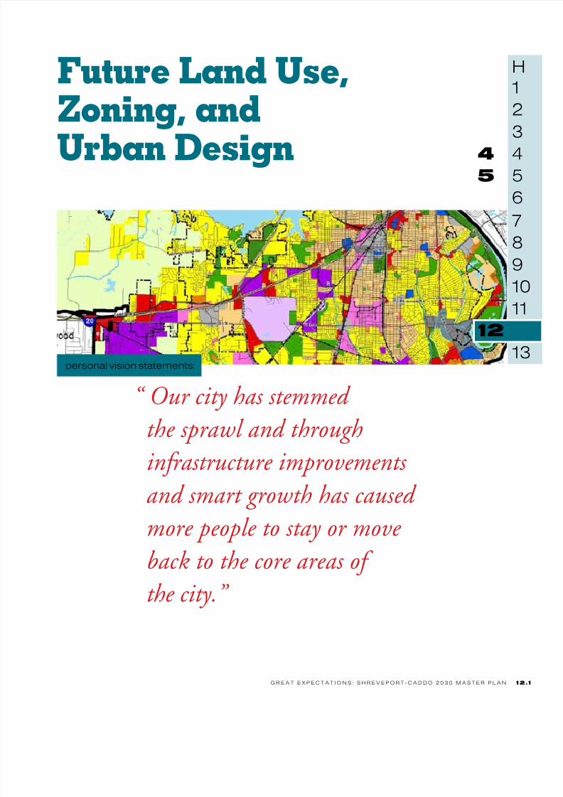
GOALS POLICIES FOR DECISION MAKERS
A smarter growth development patternwithin the master plan area
•Preserveandsupportthecharacterofstableresidentialneighborhoods.
•Provideformajormixed-usecentersdowntownandwherethereisasignicantconcentrationofjobs.
•Provideforcompactmixed-useurbanvillagesthatconcentrateretailandservicesin
walkableenvironments.•Avoidnewdevelopmentwheremajorinfrastructureextensionswouldberequired.
•Preserveandprotectenvironmentallysensitiveland.
•Promotewalkableenvironments.
A Unied Development Code that refectsthe Master Plan Vision and Goals
•Supportacompleterewriteandconsolidationofdevelopmentregulationsthatrequireshigh-qualitydevelopmentwhileprovidingclearanduser-friendlyregulationsandstreamlinedadministration.
•Enforcelandusepolicyandregulations.
Excellent urban design quality toenhance the livability o the master planarea
•Supporthigh-qualitydesigninregulationsandinlandusedecisions.
•Makethecityandparishmodelsofurbandesignquality.
8/3/2019 CH12_101221-LO
http://slidepdf.com/reader/full/ch12101221-lo 4/40
1 2 | F u u r e n d u e , z o n n g n d u r n d e g n
1 2 . 4 G r e a t e x e c t a t i o n s : s h r e v e o r t - c a d d o 2 0 3 0 M a s t e r L a n
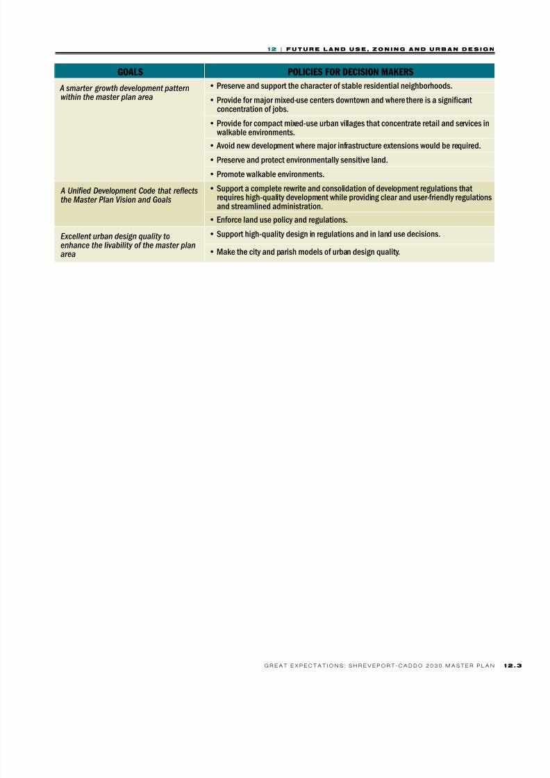
Findings
• All things being equal, more development closer to the city center is fiscally moreadvantageous.
• Existing regulations do not provide for mixed use districts.
• Older industrial areas with underutilized and vacant space need to be repurposed.
• The zoning code and subdivision regulations need to be modernized to reflect Master Planpolicies.
• Urban design practices tend to favor auto-oriented environments.
Challenges• Making small, necessary revisions to zoning before a full rewrite
• Applying master plan policies under the existing project approval process before a full rewriteof zoning.
• Coordinating application of urban design policies with public and private projects.
• Preparing a Unified Development Code.
• Ensuring public participation as part of the zoning rewrite process.
8/3/2019 CH12_101221-LO
http://slidepdf.com/reader/full/ch12101221-lo 5/40
1 2 | F u u r e n d u e , z o n n g n d u r n d e g n
1 2G r e a t e x e c t a t i o n s : s h r e v e o r t - c a d d o 2 0 3 0 M a s t e r L a n
. establishi a a us
Famwk f th Ft
Land use patterns and decisions are inuenced by population and economic growth (which create
market demand), transportation access and
opportunities, the availability of infrastructure,
environmental constraints, as well as quality
of life potential reected in school quality, parks and
recreational opportunities, and cultural amenities. Most
development decisions are made by the private sector,
but those decisions occur within a land use framework
created by zoning and other development regulations
and inuenced by public investments, incentives and
disincentives. These regulatory and incentive frameworks will not, by themselves, cause development of a specic
type to happen, but they can encourage it.
Every community master plan or comprehensive plan
contains a land use Plan and Future Land Use Map.
The Shreveport-Caddo 2030 Land Use Plan and the
Future Land Use Map set forth the policy framework
for the physical development of the Master Plan Area,
providing a guide for decision makers in directing the
pattern, distribution, density and intensity of land uses
that will, over time, best achieve the master plan’s goals forrevitalization of downtown and core city neighborhoods,
support for stable neighborhoods, job growth and
economic development, alternatives to the car, and a robust
network of greenways and green spaces. The plan aims
to direct the most efcient, functional, cost-effective and
aesthetically pleasing way to provide sufcient land to meet
demand for various land uses in the future. There is plenty
of land in the Shreveport-Caddo Master Plan Area, but
the combination of disinvestment and unplanned growth,
which has occurred for decades, has often resulted in less
than optimal development patterns.
GeoGraphical patterns of land Use:
the loGic Behind location
One of the most important purposes of a community
master plan is to promote a geographical pattern of
land uses that will enhance quality of life and economic
prosperity for the community as a whole. The well-
known real estate mantra, “location, location, location,”
is as important for the overall pattern of land use
and development within a community as it is for the
individual property owner. A “good” location is only partly an attribute of a particular piece of property (soils,
topography and vegetation can be positive or negative
depending on the proposed use); it results from the
intersection of interrelated conditions that include nearby
existing and future land uses, transportation investments,
infrastructure availability, and the likelihood for these
conditions to persist or change. Many of the conditions
that create a “good” location depend on public action
and public investment, either because of investments in
public improvements or because of regulation. This is the
origin of zoning in the United States: a way to protectsingle-family homes from the pollution and noise or other
adverse impacts of existing or future industrial or other
nonresidential uses. The legal justication for zoning rests
on government’s authority to protect public health, safety
and welfare.
How land uses are located geographically and their
relationship to one another helps create more higher-
value, “good” locations with greater overall choice and
amenities in the community as a whole, improving
quality of life and economic prosperity. Land uses
arranged so that they have benecial impacts on one
another help produce communities where the whole
results in more than the sum of the parts. A system of
well-organized land uses creates the possibility of more
choice in transportation, supports consumer-oriented
businesses, provides neighborhoods attractive to the
work force, and mitigates adverse impacts, improving
the compatibility of diverse land uses. As discussed in
previous chapters of this plan, the distribution of land
uses can also be a key determinant of infrastructure costs.
. cais f th Ft a
hi mplicatis
The vision and principles created through a public
process and adopted by the MPC gave clear direction on
Shreveport-Caddo citizens’ aspirations for the future—an
8/3/2019 CH12_101221-LO
http://slidepdf.com/reader/full/ch12101221-lo 6/40
1 2 | F u u r e n d u e , z o n n g n d u r n d e g n
1 2 . 6 G r e a t e x e c t a t i o n s : s h r e v e o r t - c a d d o 2 0 3 0 M a s t e r L a n
exciting downtown, revitalized neighborhoods in the
city core, job growth, transportation choices, and green
networks—and these aspirations have implications
for future land use. After adoption of the vision andprinciples to guide the plan and the interim Open House
for Solutions meetings for public feedback on emerging
directions of the master plan, another round of public
meetings asked Shreveport-Caddo citizens to express their
preferences on three approaches to shaping future growth
and change.
All three scenarios were based on the themes of the vision
and principles and included some basic assumptions:
• Themes
> Smarter growth: redevelopment “inside the loop”for walkable neighborhoods of choice
> Unique identity: promoting downtown’s unique
role in the ArkLaTex region as well as the
distinctive cultural and landscape heritage of the
master plan area
> Investment in “place:” creating neighborhoods of
choice and community, including ready locations
for a diverse economy
> Investment in people: a focus on education,
workforce development and attracting talent formore 21st century jobs
• Assumptions
> The master plan area will have more jobs and
households in 2030 than it does in 2010.
> The job growth rate will at least equal the Caddo
Parish average rate of job growth over the 1997-
2007 decade (a period including years of both
growth and recession).
> Population growth will be proportionate to job
growth and household size will remain the same or
smaller.
> Employment will continue to be concentrated in
the same general areas.
Each approach or scenario represented a different level
of change and investment; potential number of jobs;
potential number of new households; and location and
pattern of development and redevelopment. The three
approaches were named “Cautious,” “Focused,” and
“Bold.”
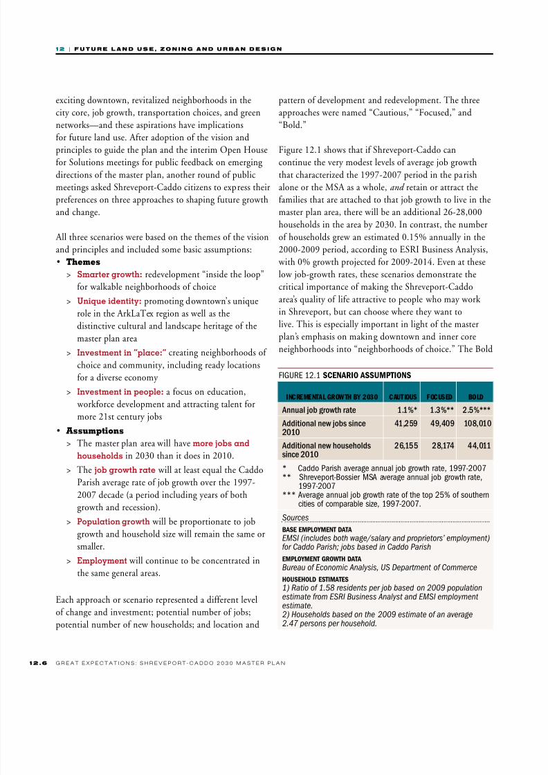
Figure 12.1 shows that if Shreveport-Caddo can
continue the very modest levels of average job growth
that characterized the 1997-2007 period in the parish
alone or the MSA as a whole, and retain or attract the
families that are attached to that job growth to live in the
master plan area, there will be an additional 26-28,000
households in the area by 2030. In contrast, the number
of households grew an estimated 0.15% annually in the
2000-2009 period, according to ESRI Business Analysis,
with 0% growth projected for 2009-2014. Even at these
low job-growth rates, these scenarios demonstrate thecritical importance of making the Shreveport-Caddo
area’s quality of life attractive to people who may work
in Shreveport, but can choose where they want to
live. This is especially important in light of the master
plan’s emphasis on making downtown and inner core
neighborhoods into “neighborhoods of choice.” The Bold
F 12.1 Scenario aSSumptionS
INCREMENtAL GROwth By 2030 CAUtIOUS FOCUSED BOLD
Annualjobgrowthrate 1.1%* 1.3%** 2.5%***
Additionalnewjobssince2010
41,259 49,409 108,010
Additionalnewhouseholdssince2010
26,155 28,174 44,011
* Caddo Parish average annual job growth rate, 1997-2007** Shreveport-Bossier MSA average annual job growth rate,
1997-2007*** Average annual job growth rate of the top 25% of southern
cities of comparable size, 1997-2007.
Sources
BaSe employment data
EMSI (includes both wage/salary and proprietors’ employment)for Caddo Parish; jobs based in Caddo Parish
employment growth data
Bureau of Economic Analysis, US Department of Commerce
houSehold eStimateS
1) Ratio of 1.58 residents per job based on 2009 populationestimate from ESRI Business Analyst and EMSI employment estimate.2) Households based on the 2009 estimate of an average2.47 persons per household.

8/3/2019 CH12_101221-LO
http://slidepdf.com/reader/full/ch12101221-lo 7/40
1 2 | F u u r e n d u e , z o n n g n d u r n d e g n
1 2G r e a t e x e c t a t i o n s : s h r e v e o r t - c a d d o 2 0 3 0 M a s t e r L a n
scenario sets a goal of incrementally reaching a 2.5%
annual rate of job growth by 2030 for the Master Plan
Area. Although higher than recent regional job growth
rates, it is not an especially high rate of growth andsimply mirrors the average growth rate over a decade for
the top quarter of southern cities of comparable size.
Each scenario was also assigned a different distribution of
development patterns for the scenario’s end year of 2030,
with the most ambitious “smart growth” pattern included
in the Bold scenario. (See Figure 12.2) Pages 12.8–12.13
contain overviews of the three scenarios.
F 12.2 2030 diStriBution of new houSeholdSBy planning area Sector
SCENARIO
SECtOR CAUtIOUS FOCUSED BOLD
1—Downtownandvicinity 5% 10% 15%
2—Corerevitalizationareas 5% 20% 25%
3—East 10% 15% 15%
4—North 15% 10% 10%
5—West 15% 10% 10%
6—Southwest 25% 17.5% 12.5%
7—Southeast 25% 17.5% 12.5%
Scenario Sectors
MAP 12.2 Scenario planning area SectorS
Scenariosectors
MAP 12.1 employment concentrationS
Scenariosectors
0–500jos
501–1,000jos
1,001–2,000jos
2,001–3,500jos
3,501–9,121jos
Employment Concentrations
Source: ESRI, 2009
8/3/2019 CH12_101221-LO
http://slidepdf.com/reader/full/ch12101221-lo 8/40
1 2 | F u u r e n d u e , z o n n g n d u r n d e g n
1 2 . 8 G r e a t e x e c t a t i o n s : s h r e v e o r t - c a d d o 2 0 3 0 M a s t e r L a n
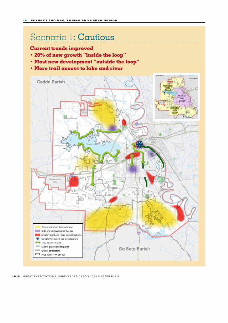
Scenario 1: CautiousCurrent trends improved
• 20% of new growth “inside the loop”• Most new development “outside the loop”
• More trail access to lake and river
Continued edge development
Infll and redevelopment areas
Employment and retail concentrations
Downtown mixed-use development
Green connections
Existing recreational paths
Existing Interstate
Proposed I-49 Corridor

8/3/2019 CH12_101221-LO
http://slidepdf.com/reader/full/ch12101221-lo 9/40
1 2 | F u u r e n d u e , z o n n g n d u r n d e g n
1 2G r e a t e x e c t a t i o n s : s h r e v e o r t - c a d d o 2 0 3 0 M a s t e r L a n
Build COmmunity• Some new housing in inner core, but
most new development outside the loop
• Improved historic preservation
initiatives• New development relates well to
adjacent development
Build prOsperity
and OppOrtunity• Up to 40,000 new jobs in 20 yrs
• Continued growth in established
industries
• Increased educational programs
ensure higher graduation rates
GO Green• More recreation options
• Some natural areas protected
• More community gardens and
greenways as unds allow
• Government buildings retroftted to
be energy-efcient
renew systems• Some water and sewer
improvements, but high costs persist
• Police, fre, and EMS provide good
service to most o the city
• Road repair and maintenance
continues on an as-needed basis
dOwntOwn• Some residential development, mostly
in adaptive reuse projects
• New arts and cultural amenities bring
more visitors to downtown
• Limited retail and job growth

8/3/2019 CH12_101221-LO
http://slidepdf.com/reader/full/ch12101221-lo 10/40
1 2 | F u u r e n d u e , z o n n g n d u r n d e g n
12. 10 G r e a t e x e c t a t i o n s : s h r e v e o r t - c a d d o 2 0 3 0 M a s t e r L a n
Scenario 2: FocusedSelected new initiatives
• 35% of new growth “inside the loop”• Some compact neighborhood centers “outside the loop”
• More trail access to lake and river
Continued edge development
Infll and redevelopment areas
Employment and retail concentrations
Downtown mixed-use development
Neighborhood center
Green connections
Existing recreational paths
Proposed recreational paths
Existing Interstate
Proposed I-49 Corridor

8/3/2019 CH12_101221-LO
http://slidepdf.com/reader/full/ch12101221-lo 11/40
1 2 | F u u r e n d u e , z o n n g n d u r n d e g n
12.G r e a t e x e c t a t i o n s : s h r e v e o r t - c a d d o 2 0 3 0 M a s t e r L a n
Build COmmunity• Infll and redevelopment increases
within the loop as edge development
decreases
• More historic properties preserved• Neighborhood centers develop at key
intersections
Build prOsperity
and OppOrtunity• Nearly 50,000 new jobs in 20 yrs
• Signifcant growth in base and
emerging industries
• Educational attainment and
training increase
GO Green• Tree canopy and quality o parks and
recreation areas improved
• Connected network o bike and
walking paths serves more residents
and destinations
• Greater access to community gardens
and armer’s markets
renew systems• Asset management system provides
programmed maintenance that saves
money
• Natural drainage corridors improve
water treatment
• Roads accommodate all users and
ITS improves trafc ow
dOwntOwn• Mixed-use downtown
neighborhood o unique districts
is born, with approximately 3,500
new households
• Enhanced historic and cultural identity
• More students and workers in downtown to support
new retail and dining establishments
2010 2030
2010
8/3/2019 CH12_101221-LO
http://slidepdf.com/reader/full/ch12101221-lo 12/40
1 2 | F u u r e n d u e , z o n n g n d u r n d e g n
12. 12 G r e a t e x e c t a t i o n s : s h r e v e o r t - c a d d o 2 0 3 0 M a s t e r L a n
Scenario 3: BoldFull engagement
• 50% of new growth “inside the loop”• “Transit ready” neighborhood centers
• Robust greenway network
Continued edge development
Infll and redevelopment areas
Employment and retail concentrations
Downtown mixed-use development
Neighborhood center
Green connections
Existing recreational paths
Proposed recreational paths
Limited or rapid service bus lines
Existing Interstate
Proposed I-49 Corridor
8/3/2019 CH12_101221-LO
http://slidepdf.com/reader/full/ch12101221-lo 13/40
1 2 | F u u r e n d u e , z o n n g n d u r n d e g n
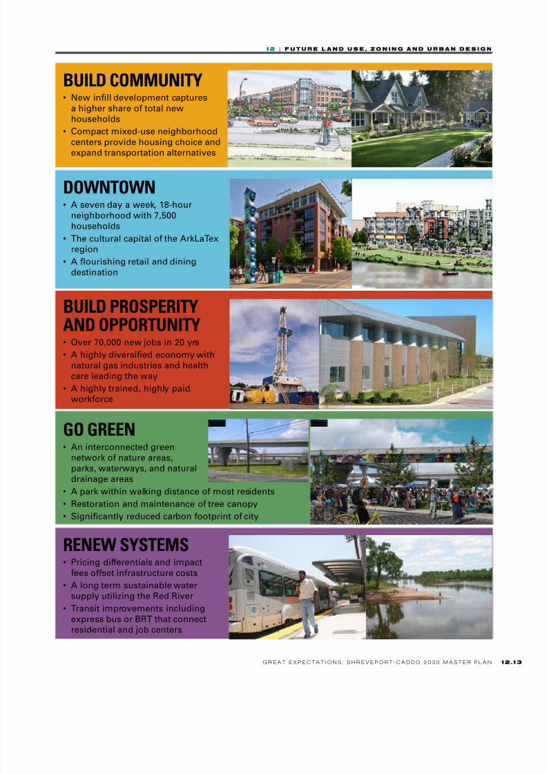
12.G r e a t e x e c t a t i o n s : s h r e v e o r t - c a d d o 2 0 3 0 M a s t e r L a n
Build COmmunity• New infll development captures
a higher share o total new
households
• Compact mixed-use neighborhoodcenters provide housing choice and
expand transportation alternatives
Build prOsperity
and OppOrtunity• Over 70,000 new jobs in 20 yrs
• A highly diversifed economy with
natural gas industries and health
care leading the way
• A highly trained, highly paid
workorce
GO Green• An interconnected green
network o nature areas,
parks, waterways, and natural
drainage areas
• A park within walking distance o most residents
• Restoration and maintenance o tree canopy
• Signifcantly reduced carbon ootprint o city
2010 2030
renew systems• Pricing dierentials and impact
ees oset inrastructure costs
• A long term sustainable water
supply utilizing the Red River
• Transit improvements including
express bus or BRT that connect
residential and job centers
dOwntOwn• A seven day a week, 18-hour
neighborhood with 7,500
households
• The cultural capital o the ArkLaTex
region
• A ourishing retail and dining
destination

8/3/2019 CH12_101221-LO
http://slidepdf.com/reader/full/ch12101221-lo 14/40
1 2 | F u u r e n d u e , z o n n g n d u r n d e g n
12. 14 G r e a t e x e c t a t i o n s : s h r e v e o r t - c a d d o 2 0 3 0 M a s t e r L a n
C. Fiscal mplicatis f th
h cais
Members of the planning team who specialize in scal-impact analysis reviewed the three scenarios for their
scal implications. The results of that analysis appears in
summary form in Figure 12.3, and the complete report is
available in the Appendix.
Fiscal-impact analysis projects future needs based on current
levels of service for the scenarios under consideration. This is
done to enable an “apples to apples” comparison among the
scenarios. In this phase of the analysis, no judgment is made
about whether the levels of service are inadequate, adequate,
or better than adequate. Nor are any assumptions madeabout future changes in levels of service or types of services
offered due to existing deciencies, different policies or
requirements, demographic shifts, technological changes, etc.
Nevertheless, levels of service will likely have to change
in some areas to attract and retain the levels of residential
and business growth assumed in this analysis and master
planning effort. In particular, infrastructure improvements
will be necessary to correct existing backlogs of deferred
needs. And the new levels of service will have to be
maintained at this improved level to retain new residentsand businesses. The next question is: who pays for those
improvements? To date, the City and Parish have assumed
most if not all of the responsibility for such improvements
and costs, using local funds and state and federal grants.
It is necessary to explore alternative funding sources andstrategies, not only to pay for improvements but also to
align incentives with the 2030 vision and goals of this
master plan. (A nal report on alternative funding strategies
is summarized in Chapter 13 and the full report is in the
Appendix.)
It is important to remember that scal issues are only
one aspect of evaluating development and growth trends.
Environmental, land use, housing, jobs/housing balance,
transportation, education, and other issues must also factor
into decisions about policies and direction for the city.
Figure 12.4 shows scal results—with revenues subtracted
from operating and capital expenditures in each year for
each of the three scenarios. (Results do not include water
and sewer.) The Cautious and Focused Scenarios are
essentially scally neutral, with early years producing annual
net surpluses and later years generating annual net decits.
The Cautious Scenario produces generally worse results than
the Focused Scenario due to the location of the projected
growth. The Focused Scenario assumes more development
in the city’s core area, which creates lower infrastructure
costs than in the Cautious Scenario.
$20,000,000
$15,000,000
$10,000,000
$5,000,000
$0
($5,000,000)
($10,000,000)
Scenario 1 cautious Scenario 2 foused Scenario 3 Bold
F 12.3 Scenario compariSonS: annual net fiScal impact from new growthFISCA-IMPAC AASIS
8/3/2019 CH12_101221-LO
http://slidepdf.com/reader/full/ch12101221-lo 15/40
1 2 | F u u r e n d u e , z o n n g n d u r n d e g n
12.G r e a t e x e c t a t i o n s : s h r e v e o r t - c a d d o 2 0 3 0 M a s t e r L a n
this theme, Shreveport provides many services free or at
very low cost (e.g., solid waste disposal) that are typically
fee-based services in other localities.
• Short-term needs vs. long-term planning. Long-term capital planning for expansion, replacement, and
renewal has been difcult because of short-term needs.
This is closely related to the rst theme. Given the City’s
expansive and aging infrastructure, short-term crises
have taken precedence over long-term capital analysis,
planning, and implementation. Good information—
such as an asset-management system; a pavement-
management system; water, sewer, and drainage master
plans; and a current utility rate study and model—
would assist with long-term planning.
All three themes carry implications for future planning and
implementation.
Fiscal sustainability and development patterns
The term “sustainability” prompts most people to think
about environmental issues, yet scal sustainability is just as
important. Fiscal sustainability requires that growth pay its
own way. New development, particularly on the periphery of
a developed jurisdiction, demands new infrastructure that may
be built by a municipality and at a minimum will be main-tained by the municipality. Tools that address growth-related
infrastructure needs (such as impact fees or capacity fees) help
ensure that growth pays its way while freeing up other revenue
to support investments in backlog infrastructure projects and
to create incentives for growth in desired locations.
By making development at the periphery of the city pay its
way, inll and redevelopment inside the loop will become
more competitive encouraging the land use development
patterns that residents of the Master Plan Area prefer.
d. aki th l ppach
In seven public open house meetings held in libraries
throughout the Master Plan Area, Shreveport-Caddo
residents were given the opportunity to learn about
the three scenarios, discuss questions and comments
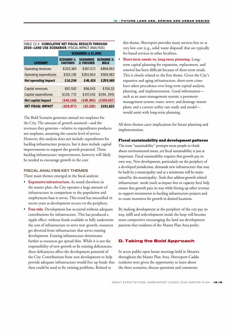
TAB 12.4 cumulative net fiScal reSultS through2030—land uSe ScenarioS (FSCA-MPACT AAySS)
SCENARIOS (x $1,000)
CAtEGORy SCENARIO 1:
CAUtIOUS SCENARIOS2: FOCUSED
SCENARIO 3:BOLD
Operating revenues $329,385 $397,572 $898,962
Operating expenditures $315,182 $350,954 $599,082
Net operating impact $14,204 $46,618 $299,880
Capital revenues $92,592 $98,043 $156,33
Capital expenditures $136, 772 $147,043 $264, 395)
Net capital impact ($44,180) ($49,000) ($108,057)
NET FISCAL IMPACT ($29,977) ($2,382) $191,823
The Bold Scenario generates annual net surpluses for
the City. The amount of growth assumed—and the
revenues they generate—relative to expenditures produces
net surpluses, assuming the current level of service.
However, this analysis does not include expenditures for
backlog infrastructure projects, but it does include capital
improvements to support the growth projected. Those
backlog infrastructure improvements, however, will likely
be needed to encourage growth in the core
fiscal analysis Key themes
Three main themes emerged in the scal analysis:
• Expansive infrastructure. As noted elsewhere in
the master plan, the City operates a large amount of
infrastructure in comparison to the population and
employment base it serves. This trend has intensied in
recent years as development occurs on the periphery.
• Free ride. Development has occurred without adequate
contributions for infrastructure. This has produced a
ripple effect: without funds available to fully underwrite
the cost of infrastructure to serve new growth, resources
get diverted from infrastructure that serves existingdevelopment. Existing infrastructure deteriorates
further as resources get spread thin. While it is not the
responsibility of new growth to x existing deciencies,
these deciencies affect the development potential of
the City. Contributions from new development to help
provide adequate infrastructure would free up funds that
then could be used to x existing problems. Related to

8/3/2019 CH12_101221-LO
http://slidepdf.com/reader/full/ch12101221-lo 16/40
1 2 | F u u r e n d u e , z o n n g n d u r n d e g n
12. 16 G r e a t e x e c t a t i o n s : s h r e v e o r t - c a d d o 2 0 3 0 M a s t e r L a n
A nal, and critical, point about this scenario: it is a
goal and a benchmark to work toward, but it is not a
prediction. In order to attain or approach these numbers,
the Shreveport-Caddo community will have to work collaboratively to pursue the strategies and implementation
actions in this master plan.
e. existi a us
As noted earlier in this plan, the distribution of land uses in
the master plan area has these characteristics:
• The majority of housing is single- or two-family
dwelling units.
• Multifamily development is located somewhat
haphazardly, with little attention paid to making it
part of a larger neighborhood. Newer multifamily
development, in particular, has often been deliberately
segregated from other land uses.
• With a few exceptions,
commercial land uses are
undened and spread at low
densities along major roads, with
many vacant or underutilized
sites except for a few favoredlocations like Youree Drive/Bert
Kouns or in smaller clusters at
Manseld Road, Pines Road,
and N. Market Street. With
the exception of centers along
Line Avenue and 70th Street,
smaller retail concentrations
that serve basic day-to-day
neighborhood needs are absent.
Instead, scattered commercial
developments pop up alongvehicle corridors, with little
consideration paid to pedestrian
access.
• Industrial land is scattered
throughout the area, with
proximity to some kind of
transportation infrastructure (rail,
with members of the planning team, and indicate their
preferences for Cautious, Focused or Bold scenarios and
approaches in the four category areas of Build Community,
Downtown, Build Prosperity and Opportunity, and GoGreen and Renew Systems. As described in Chapter 2, a
majority of participants preferred the Bold scenario.
It is important to understand that the scenario assumes
an incremental increase in the annual job growth rate
from 1.1% in 2010 and to 2.5% in 2030. That means
that, starting from an estimated total of 163,140 in 2010,
the number of jobs in Caddo Parish would grow to a
total of 233,715 jobs by 2030. Similarly, the number of
households—assuming that Shreveport-Caddo would
retain or attract the households attached to the increase in jobs—would also increase incrementally over 20 years from
an estimated total of 93,744 in 2010 to 134,297 in 2030.
This scenario would not in any way affect job or household
growth in Bossier City or Parish, since these communities
would be on their own growth trajectory.
F 12.5 Bold Scenario: projected joB growth, 2010–2030
0
2010EXISTING
163,140173,997
188,759
208,272
233,715
2015 2020 2025 2030
T O T A L J O B S
50,000
100,000
150,000
200,000
250,000
F 12.6 Bold Scenario: projected houSehold growth, 2010–2030
0
2010EXISTING
93,74499,982
108,465119,677
134,297
2015 2020 2025 2030
20,000
40,000
60,000
80,000
100,000
T O T A L H O U S E H O L D S
120,000
140,000
160,000

8/3/2019 CH12_101221-LO
http://slidepdf.com/reader/full/ch12101221-lo 17/40
1 2 | F u u r e n d u e , z o n n g n d u r n d e g n
12.G r e a t e x e c t a t i o n s : s h r e v e o r t - c a d d o 2 0 3 0 M a s t e r L a n
MAP 12.3 exiSting land uSe in the maSter plan area
Other(mostlyundeveloped)
Ruralornotsudivided
Sinle-familyresidential
Multifamilyresidential
Commercialorindustrial
Industrial
Parksandrecreation
Cemetery
Institutional:medicalandeducational
Institutional:reliious
Institutional:overnmentfacilities
Transportation
PlanninArea
Shreveportoundary
Interstatehihway
UShihway
Louisianahihway
Source: COG 2009, Goody Clancy 2010

8/3/2019 CH12_101221-LO
http://slidepdf.com/reader/full/ch12101221-lo 18/40
1 2 | F u u r e n d u e , z o n n g n d u r n d e g n
12. 18 G r e a t e x e c t a t i o n s : s h r e v e o r t - c a d d o 2 0 3 0 M a s t e r L a n
MAP 12.4 exiSting land uSe inSide the loop
Other(mostlyundeveloped)
Ruralornotsudivided
Sinle-familyresidential
Multifamilyresidential
Commercialorindustrial
Industrial
Parksandrecreation
Cemetery
Institutional:medicalandeducational
Institutional:reliious
Institutional:overnmentfacilities
Transportation
PlanninArea
Shreveportoundary
Interstatehihway
UShihway
Louisianahihway
Source: COG 2009, Goody Clancy 2010

8/3/2019 CH12_101221-LO
http://slidepdf.com/reader/full/ch12101221-lo 19/40
1 2 | F u u r e n d u e , z o n n g n d u r n d e g n
12.G r e a t e x e c t a t i o n s : s h r e v e o r t - c a d d o 2 0 3 0 M a s t e r L a n
road, or river) serving as the only organizing factor.
Much, though not all industrial land inside the loop
dates from an earlier era and is underutilized or vacant—
for example, industrial land in the Augurs area, in themedical district, and in Hollywood.
• New industrial areas have been created at the edges
of the city or in the parish, with the goal of providing
the larger, more expansive parcels major industries
prefer. Among these newer industrial areas are the
GM plant area, the Shreveport Industrial Park owned
jointly by the City and Parish, land for industrial uses
at the airport, and industrial land owned by the port.
Excluding the GM plant area, which was occupied
until the GM crisis during the Great Recession, much
of the land in these new industrial parks remains
vacant.
• Outside the loop, especially outside the city
boundaries, there is an unorganized and sometimes
chaotic mix of exurban development where land has
been subdivided for everything from mobile home
parks to large-lot subdivisions and commercial uses,
often unconnected to anything but an arterial road
and surrounded by unbuilt land.
F. tatis f chivi th
gals a th Visi
A smarter growth development pattern
within the master plan area
Goal 1
Policies:
• Preserveandsupportthecharacterofstable
residentialneighborhoods.
• Provideformajormixed-usecentersdowntownandwherethereisasignificantconcentrationof
jobs.
• Provideforcompactmixed-useurbanvillages
thatconcentrateretailandservicesinwalkable
environments.
• Avoidnewdevelopmentwheremajor
infrastructureextensionswouldberequired.
• Preserveandprotectenvironmentallysensitive
land.
• Promotewalkableenvironments.
STRATEGIES
A. Make land use decisions consistent with the
Future Land Use Map
Future Land Use Policy Map
The Policy Map provides a diagrammatic expression of
the key land use issues and changes that emerged from
the recommendations of other master plan elements:
• Creation of major walkable mixed-use centers
at employment centers, downtown, the medicaldistrict, and Youree drive. These areas, with more
residential growth and density, could become
transit hubs, first for express bus service and over
the long term for Bus Rapid Transit.
• Creation of walkable “urban villages:” smaller
mixed used areas to concentrate neighborhood-
serving retail and services along with some
residential development.
• Transformation of underutilized industrial areas
inside the loop into business parks that can
accommodate office and light industry.• Concentration of heavy industry in a few major
locations: such as the port, the GM plant area.
• A robust green network to link community
destinations and preserve environmentally
sensitive areas.
The Future Land Use Map
The Future Land Use Map is not a zoning map. It is
a map that shows the distribution of general land
use categories over the Master Plan Area. The land
use categories in the map may be represented inthe zoning code by more than one zoning district if
finer distinctions and nuances are needed to shape
development.
The Future Land Use Map reflects the vision, goals and
recommended actions in the chapters of this plan, and
it sets the land use framework for achieving the Bold
8/3/2019 CH12_101221-LO
http://slidepdf.com/reader/full/ch12101221-lo 20/40
1 2 | F u u r e n d u e , z o n n g n d u r n d e g n
1 2 . 2 0 G r e a t e x e c t a t i o n s : s h r e v e o r t - c a d d o 2 0 3 0 M a s t e r L a n
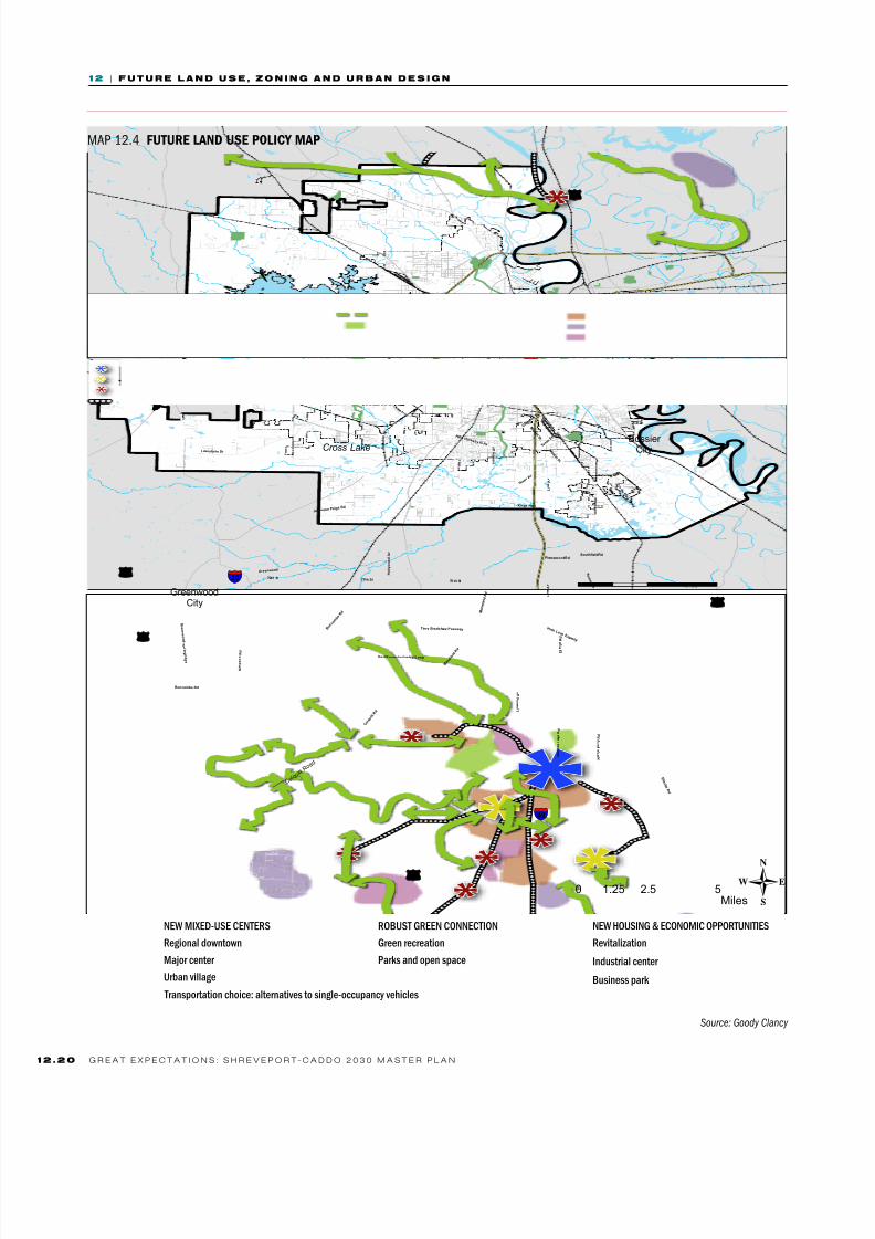
MAP 12.4 future land uSe policy map
R o y
M a r k e t S t
M a n
s f i e l d R
d
Green wood
Lakeshor e Dr
C o l q u i t t
R d
BertKouns IndustrialLoop
Pine Hill Rd
Buncombe Rd
L i n w o o d
A v
H e a r n e A v
70 thSt
N o r r i s
F e r r y R d
W a l l a c
e L a k e R
d
Je f fer son Pa ige
Rd
Blanchar d-fur r h Rd
T e x a
s A v
G r e e n w o o d - s
p r
i n g r i d
g e
S i m
p s o n
R d
Dr Martin LutherKing Jr Dr
Terry Br adshaw Passw ay
T e x a s S t
L i n e A v
C o m m
o n S t
E l l e
r b e R d
Kings Hwy
H o l l y w o o d A v
SouthfieldRd
I n n e r L o o p E x p w a y
H i l r y H u c k a b y I i i Av
PierremontRd
70th St
R o y
He ar ne Av
M a r k e t S
t
M a r k e t S t
M a r k e t S
t
L i n e A v
L a k e
s h o
r e D
r
Pine Hill Rd
B u n
c o m b e R d
70th St
M a n s f i e
l d R
d
E l l e r b e R d
§̈¦20
§̈¦220
§̈¦49
£¤171
£¤79
£¤80
£¤71
£¤71
BlanchardCity
GreenwoodCity
C o l q u i t t R o
a d
-
Cross Lake
0 2.5 51.25Miles
C l y d e F a n
t P k w y
Y o u r e e D r
Bossier City
Transportationchoice:alternativestosinle-occupancyvehicles
NEWMIXED-USECENTERS
Reionaldowntown
Majorcenter
Uranvillae
RObUSTgREENCONNECTION
greenrecreation
Parksandopenspace
NEWHOUSINg&ECONOMICOPPORTUNITIES
Revitalization
Industrialcenter
businesspark
Source: Goody Clancy

8/3/2019 CH12_101221-LO
http://slidepdf.com/reader/full/ch12101221-lo 21/40
1 2 | F u u r e n d u e , z o n n g n d u r n d e g n
1 2G r e a t e x e c t a t i o n s : s h r e v e o r t - c a d d o 2 0 3 0 M a s t e r L a n
scenario: 50% of new households to be located inside
the loop; focusing growth in compact neighborhood
centers or “urban villages,” especially outside the loop;
higher densities in these mixed-use centers to providethe basis for more transportation alternatives.
However, any land use map for the future is inevitably
based on the existing uses. Some land uses are less
susceptible to change once they have been established.
For example, occupied single-family neighborhoods
tend to stay in place over long periods, with limited
change or encroachment from other uses. Similarly,
heavy industry, once located, does not tend to move if
it continues in operation because it is difficult to find
new locations. In contrast, retail and light industrial
land uses are more likely to change, and to change
in more rapid cycles. Multifamily development is less
susceptible to change than retail uses, but more so
than single-family neighborhoods, with condos and
other ownership models less likely to change than
rental developments, which are particularly susceptible
to change if they are small, older, or run down.
The Future Land Use Map balances respect for existing
uses with designations for consolidated land uses and
new future land use designations. The consolidated
land uses on the map take two forms: a) consolidation
under one category of land uses with similar impacts,
for example, a “General Commercial” designation
for areas where a mixture of retail, service and officeuses already exists or where that mixture would be
appropriate; or b) consolidation under a predominant
use—for example, where an area is predominantly
residential but also includes schools, churches, and a
few scattered retail or office uses.
Existing development in the Master Plan Area includes
many areas that incorporate scattered instances of
other land uses. In some cases, these uses coexist
without much difficulty, such as churches and schools
located in single-family neighborhoods. In others,
different land uses or different intensities of the same
land use are located in ways that lack functional logic.
For example, areas exist in which several dead-end
streets lined with single-family houses empty onto a
collector street or major arterial and are surrounded by
a jumble of light-industrial or low-density retail uses.
In these cases, the Future Land Use Map designates
the area for the land use that would most appropriately
predominate in the area. Most of the new future land
use designations, tend to expand the number of uses in
an area, rather than limit them.
• Preserve existing occupied single- and two-family
residential neighborhoods.
• Preserve land, including areas around bayous and
drainage corridors, to achieve a green network of
interconnected parks, multi-use paths, passive and
recreational spaces.
• Encourage residential infill development on vacant
and adjudicated parcels inside the loop.• In revitalization plans and elsewhere, locate
neighborhood mixed-use centers (“urban villages”)
with residential, retail and office uses at key
intersections within walking distance of neighborhood
residences and where they could support improved
public transportation service.
• Concentrate density and mixed-use development in a
limited number of major mixed-use centers for future
bus rapid transit.
• Locate multifamily development in mixed-used centers
or urban villages; where there is nearby access to
retail, services, and public transportation; or on
collector or arterial streets and at intersections.
• Locate new housing developments adjacent to and
connected to existing development.• Avoid locating residential uses where they will be
surrounded by industrial uses.
• Locate industrial uses where there is easy access to
railroad, road, port, or air transportation.
• Establish appropriate transitions from higher-density
and higher-impact land uses to lower-density and
lower-impact land uses.
Principles To Guide Future Land Use

8/3/2019 CH12_101221-LO
http://slidepdf.com/reader/full/ch12101221-lo 22/40
1 2 | F u u r e n d u e , z o n n g n d u r n d e g n
1 2 . 2 2 G r e a t e x e c t a t i o n s : s h r e v e o r t - c a d d o 2 0 3 0 M a s t e r L a n
MAP 12.5 future land uSe map
RuralEnterprise
ResidentialLow
ResidentialMedium
ResidentialHih
NeihorhoodCommercial
generalCommercial
UranVillaeMixeduse
MajorMixedUseCenter
LihtIndustrial/businessPark
Industrial
ParksandOpenSpace
ParksandOpenSpace(PotentialNew)
Institutional
Transportation
SurfaceWater
PlanninArea
CityofShreveport
Streets
Railroads
Source: COG 2009, Goody Clancy 2010

8/3/2019 CH12_101221-LO
http://slidepdf.com/reader/full/ch12101221-lo 23/40
1 2 | F u u r e n d u e , z o n n g n d u r n d e g n
1 2G r e a t e x e c t a t i o n s : s h r e v e o r t - c a d d o 2 0 3 0 M a s t e r L a n
MAP 12.6 future land uSe map inSide the loop
RuralEnterprise
ResidentialLow
ResidentialMedium
ResidentialHih
NeihorhoodCommercial
generalCommercial
UranVillaeMixeduse
MajorMixedUseCenter
LihtIndustrial/businessPark
Industrial
ParksandOpenSpace
ParksandOpenSpace(PotentialNew)
Institutional
Transportation
SurfaceWater
PlanninArea
CityofShreveport
Streets
Railroads
Source: COG 2009, Goody Clancy 2010
8/3/2019 CH12_101221-LO
http://slidepdf.com/reader/full/ch12101221-lo 24/40
1 2 | F u u r e n d u e , z o n n g n d u r n d e g n
1 2 . 2 4 G r e a t e x e c t a t i o n s : s h r e v e o r t - c a d d o 2 0 3 0 M a s t e r L a n
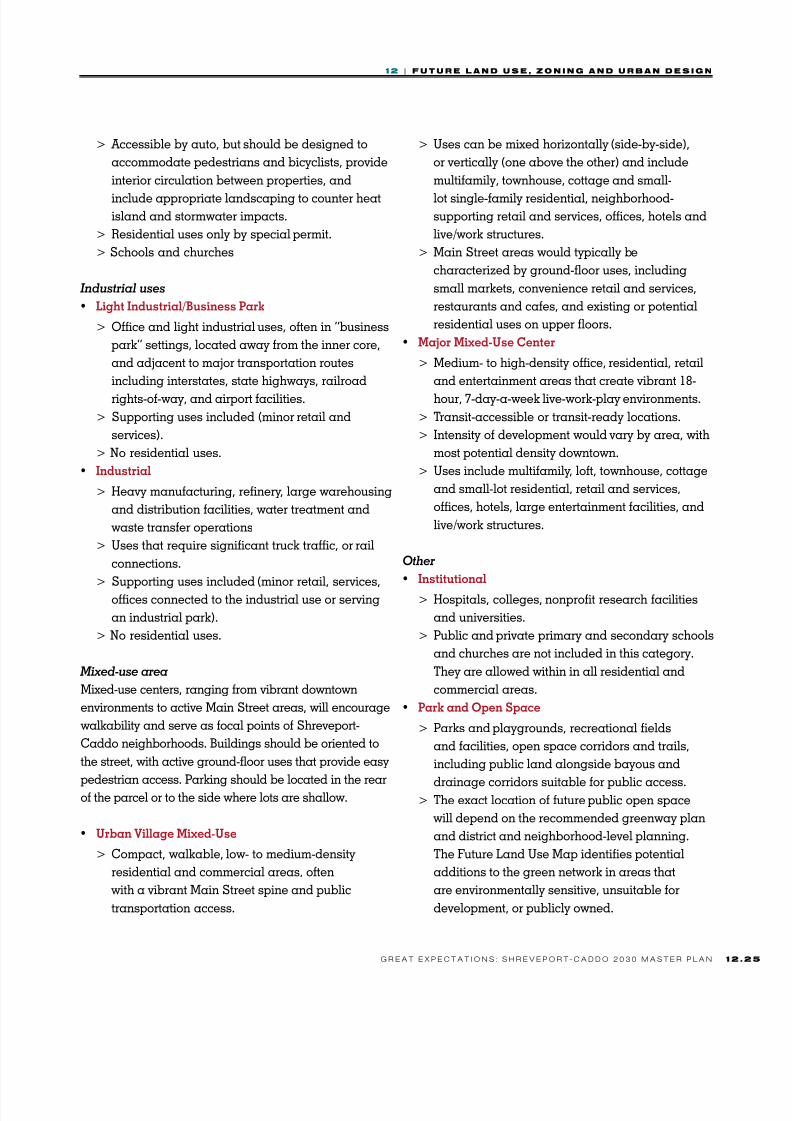
Residentialuses
• Residential Low (single-family)
> Single-family houses
> Schools and churches
• Residential Medium
> A mix of single-family, townhouse, and small
apartment buildings (fewer than eight units).
> Schools and churches also permitted, as are
corner stores by special permit.
(Typically found inside the loop where a mixture
of residential types is common.)
• Residential High (multifamily)
> Multifamily rental and condominium structures
and townhouses> Typically found at or near major transportation/
transit corridors and intersections and in
downtown-adjacent areas.
> Ground-floor, neighborhood-serving retail
allowed by special permit (e.g., corner stores).
> Schools and churches
Commercialuses
• Neighborhood Commercial
> Areas for neighborhood retail and services that
meet the day-to-day needs of residents and work-ers of surrounding neighborhoods (typically within
a one-mile radius) with a range of uses such as
smaller grocery stores, banks, restaurants and
services such as small professional and health
offices, barber/beauty shops, dry cleaners, etc.
> Areas are accessible by automobile with sufficient
parking but are also designed to accommodate
pedestrian and bicycle access.
> Schools and churches.
• General Commercial
> Large commercial areas serving a citywide orregional trade area, including shopping and
entertainment centers that offer a range of retail
and service establishments including big-box
stores, large supermarkets, department stores,
movie theaters, and supporting retail and
professional services. Office uses on upper floors
also allowed, with ground-floor retail encouraged.
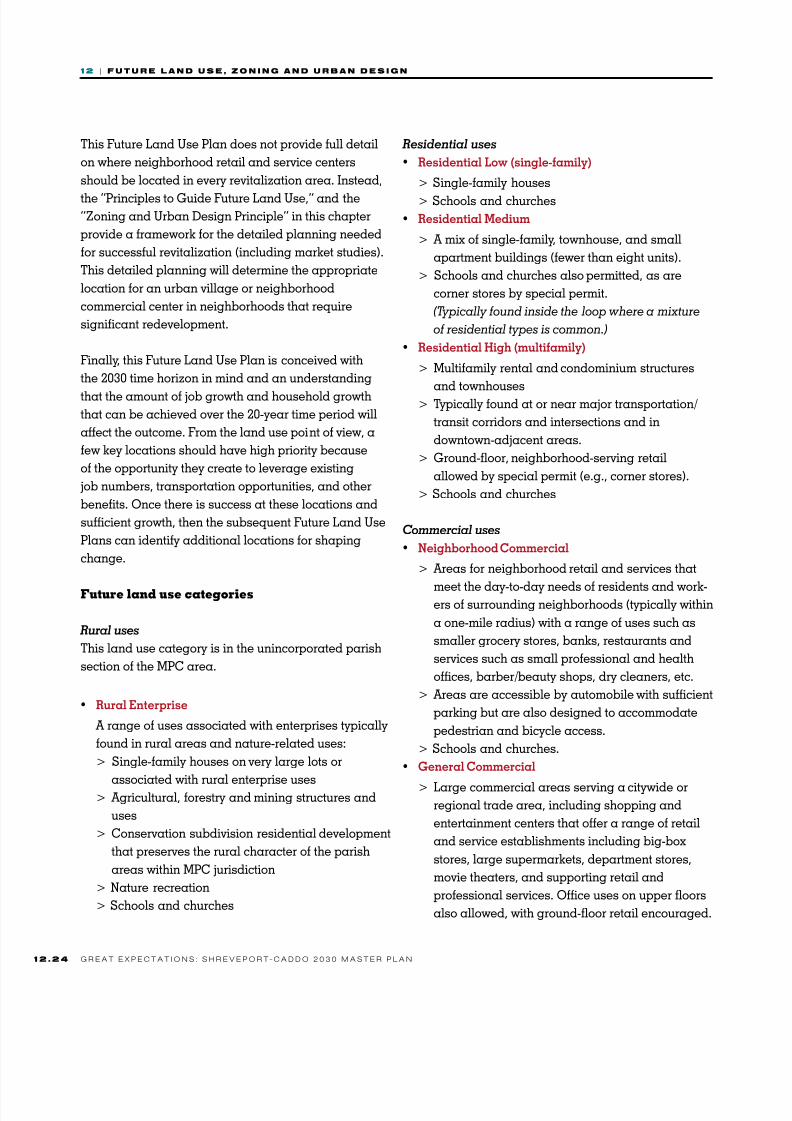
This Future Land Use Plan does not provide full detail
on where neighborhood retail and service centers
should be located in every revitalization area. Instead,
the “Principles to Guide Future Land Use,” and the“Zoning and Urban Design Principle” in this chapter
provide a framework for the detailed planning needed
for successful revitalization (including market studies).
This detailed planning will determine the appropriate
location for an urban village or neighborhood
commercial center in neighborhoods that require
significant redevelopment.
Finally, this Future Land Use Plan is conceived with
the 2030 time horizon in mind and an understanding
that the amount of job growth and household growth
that can be achieved over the 20-year time period will
affect the outcome. From the land use point of view, a
few key locations should have high priority because
of the opportunity they create to leverage existing
job numbers, transportation opportunities, and other
benefits. Once there is success at these locations and
sufficient growth, then the subsequent Future Land Use
Plans can identify additional locations for shaping
change.
Future land use categories
Ruraluses
This land use category is in the unincorporated parish
section of the MPC area.
• Rural Enterprise
A range of uses associated with enterprises typically
found in rural areas and nature-related uses:
> Single-family houses on very large lots or
associated with rural enterprise uses> Agricultural, forestry and mining structures and
uses
> Conservation subdivision residential development
that preserves the rural character of the parish
areas within MPC jurisdiction
> Nature recreation
> Schools and churches
8/3/2019 CH12_101221-LO
http://slidepdf.com/reader/full/ch12101221-lo 25/40
1 2 | F u u r e n d u e , z o n n g n d u r n d e g n
1 2G r e a t e x e c t a t i o n s : s h r e v e o r t - c a d d o 2 0 3 0 M a s t e r L a n
> Accessible by auto, but should be designed to
accommodate pedestrians and bicyclists, provide
interior circulation between properties, and
include appropriate landscaping to counter heatisland and stormwater impacts.
> Residential uses only by special permit.
> Schools and churches
Industrialuses
• Light Industrial/Business Park
> Office and light industrial uses, often in “business
park” settings, located away from the inner core,
and adjacent to major transportation routes
including interstates, state highways, railroad
rights-of-way, and airport facilities.
> Supporting uses included (minor retail and
services).
> No residential uses.
• Industrial
> Heavy manufacturing, refinery, large warehousing
and distribution facilities, water treatment and
waste transfer operations
> Uses that require significant truck traffic, or rail
connections.
> Supporting uses included (minor retail, services,
offices connected to the industrial use or serving
an industrial park).
> No residential uses.
Mixed-usearea
Mixed-use centers, ranging from vibrant downtown
environments to active Main Street areas, will encourage
walkability and serve as focal points of Shreveport-
Caddo neighborhoods. Buildings should be oriented to
the street, with active ground-floor uses that provide easy
pedestrian access. Parking should be located in the rearof the parcel or to the side where lots are shallow.
• Urban Village Mixed-Use
> Compact, walkable, low- to medium-density
residential and commercial areas, often
with a vibrant Main Street spine and public
transportation access.
> Uses can be mixed horizontally (side-by-side),
or vertically (one above the other) and include
multifamily, townhouse, cottage and small-
lot single-family residential, neighborhood-supporting retail and services, offices, hotels and
live/work structures.
> Main Street areas would typically be
characterized by ground-floor uses, including
small markets, convenience retail and services,
restaurants and cafes, and existing or potential
residential uses on upper floors.
• Major Mixed-Use Center
> Medium- to high-density office, residential, retail
and entertainment areas that create vibrant 18-
hour, 7-day-a-week live-work-play environments.
> Transit-accessible or transit-ready locations.
> Intensity of development would vary by area, with
most potential density downtown.
> Uses include multifamily, loft, townhouse, cottage
and small-lot residential, retail and services,
offices, hotels, large entertainment facilities, and
live/work structures.
Other
• Institutional
> Hospitals, colleges, nonprofit research facilities
and universities.
> Public and private primary and secondary schools
and churches are not included in this category.
They are allowed within in all residential and
commercial areas.
• Park and Open Space
> Parks and playgrounds, recreational fields
and facilities, open space corridors and trails,
including public land alongside bayous and
drainage corridors suitable for public access.> The exact location of future public open space
will depend on the recommended greenway plan
and district and neighborhood-level planning.
The Future Land Use Map identifies potential
additions to the green network in areas that
are environmentally sensitive, unsuitable for
development, or publicly owned.

8/3/2019 CH12_101221-LO
http://slidepdf.com/reader/full/ch12101221-lo 26/40
1 2 | F u u r e n d u e , z o n n g n d u r n d e g n
1 2 . 2 6 G r e a t e x e c t a t i o n s : s h r e v e o r t - c a d d o 2 0 3 0 M a s t e r L a n
• Transportation
> Airport, major train yards, and interstate/highway
rights-of-way
> Green rights-of-way of loop highways should
include multi-use paths where possible as a way
to better connect the greenway network
In conjunction with a rewrite of the MPC’s zoning,
subdivision and other development regulations,
judicious investment in the public realm, private
investment in response to the planning framework
and incentives, and public-private partnerships, the
Shreveport-Caddo community will begin to see the
achievement of the goals that citizens called for in the
visioning phase of the master plan.
A unified development code that reflects
the master plan vision and goals.
Goal 2
Policies:
• Supportacompleterewriteandconsolidation
ofdevelopmentregulationsthatrequireshigh
qualitydevelopmentwhileprovidingclear
anduser-friendlyregulationsandstreamlined
administration.
• Enforcelandusepoliciesandregulations.
STRATEGIES
A. Implement the master plan by rewriting the
zoning code and other development standards
in a unified development code.
The zoning code is one of the primary tools for
implementing the master plan. A new code will helppreserve the character of places that residents want
to keep unchanged while creating opportunities
for physical and economic growth. It is important,
therefore, that people who want to invest in the
community know where they can locate, what the
rules are, and that those rules are consistently and
predictable applied. A new zoning code will make
Shreveport and the Master Plan Area a better place to
live and to invest by:
• Setting clear standards. Develop site designstandards that enhance the function and
appearance of the entire area.
• Removing obstacles. Eliminate or modify rules
that unnecessarily hinder development.
• Creating incentives. Provide flexibilities that
encourage real estate and business development.
The existing zoning ordinance has all the characteristics
of a code that has been added to incrementally and
has not been comprehensively reviewed or revised in
many years. The brief review of the current zoning
code and other development ordinances in Chapter
3 demonstrated the need for across the board
improvements to modernize the zoning code and
development ordinances. (The appendix contains a
stand-alone version of this review of the zoning code.)
The most effective way to reform the development
regulation and permitting process is to create a unified
development code that encompasses zoning, subdivision
regulations, street and thoroughfare regulations,
development standards, environmental regulations,
sign regulations, historic preservation regulations, and
permitting and annexation rules.
Regulation of development in the MPC area has
devolved into an unpredictable and time-consuming
process. Except for single- and two-family projects, every
development project must win approval from the MPC
and City Council before receiving a building permit,
and a very large number of cases involve rezoning. This
situation developed as a way for the MPC to have the
opportunity to tailor projects to specific conditions, to
allow for public comment in the absence of planning
processes, and, theoretically, to evaluate how a project
fits an area as a whole. In fact, the absence of a master
plan or land use plan over many years has left the MPC
with no broad framework within which it can make
decisions. This highly unusual system has, in effect,
done away with as-of-right zoning for any nonresidential
8/3/2019 CH12_101221-LO
http://slidepdf.com/reader/full/ch12101221-lo 27/40
1 2 | F u u r e n d u e , z o n n g n d u r n d e g n
1 2G r e a t e x e c t a t i o n s : s h r e v e o r t - c a d d o 2 0 3 0 M a s t e r L a n
or multifamily project. As a result, project approval is
widely viewed as both unpredictable and excessively
time-consuming. The zoning code in particular, and
other development regulations as well, are in needof a complete overhaul to make them more user-
friendly, informative, and predictable—while creating
mechanisms to promote higher quality in both planning
and construction.
This new unified development code (UDC) should take
advantage of new approaches to development regulation
that have emerged over the last 30 years. Today, new
codes for entire jurisdictions are generally hybrids of
several zoning approaches, so that the right approach is
tailored to a particular place.
Approaches to zoning
Land use zoning first appeared in the United States
in 1916. The zoning system that emerged in the
early twentieth century is now called conventional or
“Euclidean” zoning (after Euclid v. Ambler, the 1926
Supreme Court case that validated zoning as a proper
exercise of municipal police power). As some of the
disadvantages of conventional zoning became evident
by the second half of the twentieth century, new zoning
approaches emerged, including performance zoning
and form-based (also called design-based) zoning.
Conventional zoning remains the basis of most zoning
systems today, but many jurisdictions have added
aspects of performance zoning and form-based zoning.
Conventional Zoning. Conventional zoning was
originally created to separate industrial and other
noxious land uses from residential areas, and
particularly to preserve quality of life and property
values in single-family neighborhoods. Conventional
zoning regulates the uses and dimensions of
development, for example:
• type and mix of land uses
• size and dimension of lots
• type, size and height of buildings
• distance of front, side and rear setbacks
• width and length of streets and sidewalks
• amount and size of off-street parking
Conventional zoning separates land uses deemed
incompatible and is prescriptive, in that it specifies
land uses and required maximum or minimum
dimensions, parking, and so forth. This prescriptivecharacter makes it easy to implement both by
governments and by property owners, because
there are no judgment calls when the zoning says,
for example, that a building must be ten feet from
the front lot line. However, conventional zoning also
focuses on proscription, that is, it focuses on what is
not allowed rather than articulating what is actually
desired. Conventional zoning provides some certainty
about development outcomes and, because it is long-
established, it is familiar to everyone, but it is inflexible
and inhibits design creativity. It is one, though not the
only, source of the “Anywhere, USA” sprawl landscape
that has produced a built environment lacking in
distinctiveness.
The homogenizing and inflexible outcomes of
conventional zoning have led to the establishment of
an array of strategies to get around that inflexibility.
Variances, conditional uses, special exceptions,
bonuses and incentives, planned unit developments,
and similar devices are intended to allow development
to be more closely tailored to particular conditions and
desired results. All of these devices can be found in the
Shreveport MPC zoning code, making it complex and
confusing.
Performance Zoning. Performance zoning has its
origins in industrial performance standards that
identified limits on measurable industrial impacts
such as noise, vibration, light, dust, smells, and so
on, and that were incorporated into zoning codes
for industrial land uses. This idea was expanded in
performance zoning to regulation of the effects of
the built environment. Unlike conventional zoning,
which assumes certain uses are incompatible and
separates them, pure performance zoning assumes
virtually any use can be made compatible if impacts
are properly managed. Because it provides flexibility
to developers and designers to present their own
solutions to mitigate impacts for administrative review,
8/3/2019 CH12_101221-LO
http://slidepdf.com/reader/full/ch12101221-lo 28/40
1 2 | F u u r e n d u e , z o n n g n d u r n d e g n
1 2 . 2 8 G r e a t e x e c t a t i o n s : s h r e v e o r t - c a d d o 2 0 3 0 M a s t e r L a n
the specific outcomes are not always predictable.
Generally speaking, performance zoning requires
highly-trained administrators who have the confidence
of both residents and developers. Performance zoningemerged in the 1970s and 1980s. Few locales have a
pure performance zoning system, but some aspects
of performance zoning are incorporated into many
communities’ zoning codes.
Form-Based Zoning. Form-based zoning focuses more
on building form than on land uses. Form-based
codes are based on the concept of a transition from
low densities and building forms at the periphery to
high densities at the center—of a city, a district or a
neighborhood. This transition is called “the transect”
in form-based zoning. These codes are a reaction to
conventional zoning’s separation of land uses, which
made it impossible to build mixed-use neighborhoods
and districts, and its neglect of the public realm, which
resulted in visually- and functionally-impoverished
environments that are often ugly, and often functional
only for one type of user. Form-based codes are very
detailed and prescriptive about certain aspects of
design and use many visuals to give a positive vision
of what is desired, rather than focusing on what should
be excluded. They require a design-focused community
process in advance of writing the zoning. In existing
communities, these kinds of codes have generally been
applied in specific districts, such as downtown or in
commercial corridors, rather than citywide.
Hybrid Zoning. Conventional, performance, and
form-based zoning codes all have advantages and
disadvantages. Because of its familiarity and long
institutional history, conventional zoning is likely to
remain the foundation of most zoning codes. However,
performance standards and form-based elements
represent effective tools for increasing the flexibility of
conventional zoning. For example, conventional zoning
is organized in separate-use districts on a citywide
basis but is not effective in mediating impacts at the
edges of districts—which is precisely the strong point of
performance zoning. Form-based codes are organized
around the street and the neighborhood and are
particularly good at conveying what is desired in terms
of the relationship between private buildings and the
public street.
Usability and Consistency. The foundation of a new
UDC can continue to be the conventional zoning model,
but aspects of performance zoning and form-based
zoning should be incorporated, giving the new UDC
these characteristics:
• a single, uniform set of definitions and
terminology
• a refined list of zoning districts and a new land
use classification system
• integrated procedures with step-by-step details on
the sequence of development approvals
• illustrated design guidelines and standards
• a detailed table of contents and index
• hyperlinks to code sections (in the electronic
version) and site design standards
• a completely new look featuring a new and
improved page layout.
As a rule of thumb, the fewer the zoning districts in
an ordinance, the easier the regulations will be to
understand and administer. The Shreveport Master
Plan Area currently has 98 zoning districts, including 51
residential districts and a number of special districts.
New zoning districts proliferated over time to solve
specific perceived problems. This is a symptom of a
zoning code that has not been overhauled in many
decades and that does not reflect an overall vision for
development. Many of the residential zoning districts
have similar dimensional and density requirements
with little variation and could be combined or
consolidated. In older parts of the city, some zoning
districts do not reflect current densities or residential
types. There are no mixed-use zoning districts.
The current ordinance does not enable the MPC to
implement new development concepts contained in the
master plan, such as mixed-use districts; new design
and development guidelines for commercial areas,
corridors, and mixed-use districts; subdivision design
modifications; and alternative options. It would be

8/3/2019 CH12_101221-LO
http://slidepdf.com/reader/full/ch12101221-lo 29/40
1 2 | F u u r e n d u e , z o n n g n d u r n d e g n
1 2G r e a t e x e c t a t i o n s : s h r e v e o r t - c a d d o 2 0 3 0 M a s t e r L a n
difficult to implement these objectives using the existing
ordinance. The new strategies under consideration for
the updated code are directed toward creating more
compact and mixed-use development at human-scaledenvironments with more connectivity.
Action
1. Use the principles on pp. 12.30–12.31 to
guide the rewrite of zoning and development
regulations.
B. Revise subdivision regulations, especially for the
unincorporated parts of the Master Plan Area.
Actions
1. Devise subdivision policies and regulations that
discourage leapfrog development.
Subdivision regulations play an extremely
important role in shaping growth outside the loop.
The current land use framework for development
in the unincorporated part of the master plan
area easily allows for small-lot subdivisions
or multifamily developments. This promotes
inefficient land use through leapfrog, exurban
growth; fragmentation of remaining rural land;
and more vehicle miles traveled. Zoning and
subdivision options for the Rural Enterprise land
use category should be crafted to discourage
leapfrog development and to require petitions for
zoning changes before proposals for residential
subdivisions can be entertained. This gives the
MPC greater ability to make a judgment on the
proposed design character and appropriateness
of the proposed subdivision in relation to the
vision and goals of this master plan. Because
a subdivision plan is a site master plan, design
choices can make a big difference in both the
internal quality of a subdivision and the way that
it relates to developed and undeveloped land
around it. New options for subdivision design can
promote development more compatible with the
master plan vision:
> Encourage more transportation choices,
connectivity, walkability and environmental
benefits through elements such as shorter
blocks, pedestrian and bicycle amenities,narrower streets, and more variety in street
design.
> Encourage parks and open space in networks
through clustering of house lots to provide
more usable open space and location of open
space to protect sensitive lands and connect
to regional greenway corridors along streams
and floodplains.
> Encourage more cost-efficient infrastructure
investments by clustering house lots to reduce
the length of pipes and volume of asphalt
required.
Subdivision regulations that provide more
flexibility within an overall framework of
desired outcomes will promote more thoughtful
subdivision site planning while allowing
developers to be more cost-efficient in their
infrastructure investments—investing more in the
initial design phase than before, but saving on
the costs of infrastructure and paving.
Excellent urban design quality to enhance
the livability of the Master Plan Area.
Goal 3
Policies:
• Supporthighqualitydesigninregulationsandin
landusedecisions.
• Makethecityandparishmodelsofurbandesign
quality.
Many of the issues central to the master plan require
new approaches to urban design as an integral part
of the implementation program. But what is “urban
design”? In the broadest terms, urban design is the
process that shapes physical environments at a variety
of scales, from regions and cities as a whole, to city
districts or neighborhoods, down to individual lots.
8/3/2019 CH12_101221-LO
http://slidepdf.com/reader/full/ch12101221-lo 30/40
1 2 | F u u r e n d u e , z o n n g n d u r n d e g n
1 2 . 3 0 G r e a t e x e c t a t i o n s : s h r e v e o r t - c a d d o 2 0 3 0 M a s t e r L a n
P r i n c i p l e s f
o r N e w Z
o n i n g
A modern zoning ordinance is more thanrequirements and mandates. It should make it
easy to do the right thing. Obstacles that stand in
the way of desirable development practices should
be removed, and the connection to the land use
policies of the master plan should be evident in the
both the text and the zoning map.
Consistency with the Master Plan• Provide for systematic neighborhood, citizen,
and property owner input into proposed zoning
changes.• Create districts and regulations to provide
the MPC with land use tools to implement the
master plan vision and goals.
• Connect zoning to the master plan by basing
the zoning map on the land use element of the
master plan and the Future Land Use Map.
Usability, Streamlining,and Administration• Eliminate obstacles to development by
deregulating routine matters, minimizingnonconformities, and eliminating unnecessary
and redundant regulations.
• Whenever possible and without losing desired
development outcomes, replace discretion and
administrative interpretation with standards to
make regulation consistent and predictable for
development decision making.
• Make administrative provisions and processes
consistent, predictable and understandable for
anyone using the zoning ordinance—resident,
property owner, developer, or staff person.• Make the ordinance easier to understand by
modernizing terms and using appropriate
illustrations, tables, matrices and charts.
• Establish a more advanced design review
process linked to thresholds of impact. For
example, require review by the MPC Board and
public hearings for projects that meet a certainsize or impact, such as all projects at or above
50,000 sf, all projects with traffic impacts above
a certain level, and so on.
• Institute planned development review for
larger projects to better integrate new projects
into their context. While this is especially
appropriate for campus-like developments, this
can be beneficial in numerous types of other
non-residential development.
• Provide for approval criteria and written findings
to be made by the MPC and the City Council inall land use decisions.
• Create a design review process that informs
both the developer and the neighbors of
community design standards and operational
concerns.
Rural Area PrinciplesOver the long term, continuation of the leapfrog
and sprawl development pattern in the unincorpo-
rated parish areas of the MPC jurisdiction—mul-
tiple small subdivisions, multifamily development,and mobile home parks emptying onto long corri-
dors of low-density commercial development—will
result in traffic congestion and lack of amenities,
eventually overwhelming the Caddo Parish land-
scape that Shreveport-Caddo residents admire.
• Establish an as-of-right minimum lot size for
residences that reflects rural conditions, such as
25 acres.
• Establish urban village zones to encourage
compact development of commercial and
higher-density uses.• Require rezoning to a residential district and
consideration of open space, transportation,
infrastructure and Master Plan issues
before allowing suburban-style subdivision
development.
• Provide for “conservation/open space
Principles to guide new zoningand the Unified Development Code

8/3/2019 CH12_101221-LO
http://slidepdf.com/reader/full/ch12101221-lo 31/40
1 2 | F u u r e n d u e , z o n n g n d u r n d e g n
1 2G r e a t e x e c t a t i o n s : s h r e v e o r t - c a d d o 2 0 3 0 M a s t e r L a n
subdivisions” that cluster housing in order
to keep the rest of the property for nature,
agricultural or forestry uses.
• Consider establishing “right to farm” standards
that recognize common agricultural andforestry activities as having precedence over
expectations of subdivision residents.
• Establish development standards for rural light
industry to minimize off-site impacts.
Residential Neighborhood PrinciplesSingle- and two-family residential
• Review residential zoning districts to ensure
that they reflect existing or desired character
and consolidate residential zoning districts
that do not result in significant variations indevelopment.
• Integrate character standards into residential
district regulations where there is a desire to
maintain existing residential character.
• Ensure that new infill or redevelopment housing
built in the older parts of the city is compatible
with the patterns established by the historic
street grid, traditional orientation of front doors
to the street, average setbacks, and parking
strategies (parking on street, in alleys or at rear
where driveways are not part of the traditionalstreetscape).
• Ensure that new infill in suburban-style
developments is compatible with established
patterns.
Multifamily (including townhouse)
• Connect multifamily housing to its surrounding
neighborhood by integrating it into the street
system and providing regulations that ensure
proper transitions from lower- to higher-density
development.• Ensure that multifamily housing is sensitive to
its context by creating design and development
standards that are compatible with the
surrounding residential neighborhoods.
• Encourage adaptive reuse of historic structures
by including development flexibilities and
exemptions, linked to specific criteria, that will
eliminate the need for variances and streamline
the approval process.
Commercial District Principles• Create standards for compact, neighborhood-
oriented commercial districts that mitigate
impacts on residential areas.
• In older parts of the city where corner stores
have been traditional, provide special-permit
processes within the residential zoning district
to support the continued existence of such uses
and to ensure that they are compatible with the
neighborhood.
• Create a commercial district specifically
designed to accommodate and encouragepedestrian-oriented, walkable shopping
environments.
• Create commercial districts where shoppers
arrive primarily by auto to be pedestrian-
friendly and functional, but where parking is
not the most visually prominent land use.
• Revise the current commercial district
standards to ensure a high quality of design
and integration with other uses, as well as
safety and comfort for pedestrians.
• Map commercial areas on the zoning map,based upon the future land use map and
master plan policies to create compact
commercial and mixed-use development.
• Include design standards for each scale of
commercial development.
• Locate mixed-use development on the zoning
map within or near commercial areas. Mixed-
use development can also function as a buffer
between large-scale commercial development
and adjacent neighborhoods.
• Tailor sign standards to the district, both interms of the types of signs allowed and their
size. The regulations should work to achieve a
coordinated appearance within a commercial
area or along commercial corridors.
P ri n ci pl e sf or
N ew Z oni n g

8/3/2019 CH12_101221-LO
http://slidepdf.com/reader/full/ch12101221-lo 32/40
1 2 | F u u r e n d u e , z o n n g n d u r n d e g n
1 2 . 3 2 G r e a t e x e c t a t i o n s : s h r e v e o r t - c a d d o 2 0 3 0 M a s t e r L a n
P r i n c i p l e s f
o r N e w Z
o n i n g
Districts with Mixed UsesMixed-use areas combine diverse uses, mixed
horizontally and vertically, each of which must
be individually successful while contributing to a
larger experience and identity. This does not meanthat every property within a mixed-use center must
contain more than one land use. What it does
mean is that mixed-use properties and buildings
will be permitted; that single-use sites will be
designed to be compatible with other desired uses
in the mixed-use center; and that the public and
semipublic realm (streets, sidewalks, parking lots,
building setbacks, building facades, landscaping)
will be designed to work together and create
human-scaled, walkable environments while
still accommodating cars, loading and similarnecessities
The Future Land Use Map identifies three Major
Mixed-Use Areas: Downtown; the core medical
district redevelopment area from LSU Health to
Willis Knighton; and the Youree Drive retail and
multifamily-development area near LSUS. Urban
Village Mixed-Use Areas occur in two kinds of
locations: as a medium-density adjacent area next
to a Major Mixed-Use Area; and as existing retail
centers or intersections appropriate for compact, walkable centers with retail and services to support
nearby residential areas. Over time, as the number
of households grows and the revitalization of
core neighborhoods becomes more successful,
additional mixed-use areas may prove suitable.
Because mixed-use development is more complex,
it will require more design and standards review
than development in other zoning districts. Some of
this can be accomplished through administrative
review based on clear standards, but in the case
of larger projects, or projects with bigger impacts,
a public hearing and approval by the MPC Board
would be necessary.
• Provide regulations to insure proper transitions
from lower- to higher-density development.
• Create districts for mixed-use development of
various scales. This includes vertical mixed-
use (within one building) and mixed-use on the
broader neighborhood level.
• Establish urban design goals and standards for
mixed-use districts that emphasize pedestrian-oriented ground floors, sidewalks and streets.
• Manage the amount, location, and design
of parking to support urban design goals in
mixed-use districts; require, where appropriate,
contributions to a network of open spaces
through the development approval process.
• Establish zoning for downtown that reflects
the mix of subdistricts identified in the master
plan, transforming it from a series of individual
destinations into a cohesive, interconnected,
and well-managed center:> Continue to allow higher heights and
densities in downtown than elsewhere,
particularly in the Central Business District.
> Establish a system of primary streets with
design standards that are characterized by
continuous zero-lot-line street wall, active
ground-floor uses, transparency (percentage
of the building frontage with windows) and
permeability (building frontage with doors
opening on to the street).
> Establish regulations to promote adaptivereuse of historic buildings, using the National
Register Shreveport Commercial Historic
District as the focus of adaptive reuse efforts.
> Support historic investments by
removing unnecessary obstacles to the
rehabilitation of existing buildings such
as parking requirements and expansion of
nonconforming uses.
Business Park and Industrial Uses
• Reduce conflicts both within industrial districtsand between industrial districts and adjacent
non-industrial districts.
• Provide appropriate locations for business
and light industrial facilities in attractive and
accessible settings.
• Refine the current industrial district structure
8/3/2019 CH12_101221-LO
http://slidepdf.com/reader/full/ch12101221-lo 33/40
1 2 | F u u r e n d u e , z o n n g n d u r n d e g n
1 2G r e a t e x e c t a t i o n s : s h r e v e o r t - c a d d o 2 0 3 0 M a s t e r L a n
to accommodate a range of industrial
development, including standards for research
and light industrial/office parks.
• Include design standards for both buildings
and the larger design of the site for industrial,business, and research parks. Design standards
will help to mitigate impacts and assure a
desired aesthetic image.
• Review performance standards for industry in
establishing uses and evaluating impacts near
residential areas.
• Include new landscaping standards to buffer
incompatible uses, screen parking lots and
outdoor storage areas, and improve the
appearance of the site and street frontage.
Institutional Uses• Create zoning districts that accommodate large
office, medical and educational employment
centers, such as Willis-Knighton, LSU
Health, and LSUS. Specific zoning for such
developments can facilitate a more orderly
and efficient regulation process. In some cities,
zoning requires institutions to file an institutional
master plan that indicates future development
plans within five or ten years. Institutional
district development regulations should clearly indicate the scope of each development,
requirements for transitions between campus
activities and adjacent neighborhoods,
and procedures for addressing concerns
involving the institution, the City and adjacent
neighborhoods.
• Allow mixed-use development in institutional
districts.
• Establish appropriate boundary transitions
between major uses and surrounding
neighborhoods to ensure good neighborcompatibility.
Open Space DistrictsOpen space zoning is a way to make sure that at
minimum, proposals to change from open space to
other uses will have to go through a public process
and seek new zoning. Open space zoning districts
typically limit structures to a low floor area ratio
and require any structures be supportive of the
open space uses.
• Zone public parks, rights-of-way alongdrainage ways and bayous, wetlands, and other
recreational or environmentally sensitive lands
as open space.
• Provide appropriate locations for open spaces
and public recreational areas.
• Distinguish between conservation and
recreation areas.
Sustainability and EnvironmentalStandards
Zoning for sustainability helps shape developmentthat is energy- and resource-efficient, minimizes
the impact of human land uses, and promotes
compatibility with local climate and environmental
systems.
Zoning can support and encourage sustainable
development by eliminating or revising existing
rules that unnecessarily hinder sustainable
development, providing incentives to encourage
sustainable design techniques, and requiring basic
sustainable development standards that addresslandscape, building materials, and building siting,
and relate the location of use types and densities to
public transportation access.
• Promote the use of water conservation and
innovative stormwater-management techniques
in site planning and new construction, including
the use of semipervious paving materials, where
conditions are suitable.
• Encourage, and in some cases require, sustain-
able stormwater management, scaled to the size
and character of the site, such as bioswales,green roofs, and parking lot landscaped islands
designed to absorb stormwater.
• Include parking alternatives, such as shared
parking lots and parking space maximums, to
reduce the amount of paved surfaces in a new
development.
P ri n ci pl e sf or
N ew Z oni n g

8/3/2019 CH12_101221-LO
http://slidepdf.com/reader/full/ch12101221-lo 34/40
1 2 | F u u r e n d u e , z o n n g n d u r n d e g n
1 2 . 3 4 G r e a t e x e c t a t i o n s : s h r e v e o r t - c a d d o 2 0 3 0 M a s t e r L a n
• Allow for land banking of parking facilities—
where a portion of a parking area is kept in
green space until the paving of additional
parking areas is proved necessary because
of sufficient parking demand—to reduceimpervious surfaces.
• Allow urban agriculture in appropriate locations,
including small scale beekeeping, poultry and
similar activities, where appropriate. In addition,
community gardens can be permitted as well as
required for certain types of new construction,
such as large multifamily developments.
• Permit temporary farmers markets in certain
districts, subject to regulations, so that
locally-grown produce can be sold within the
community.• Allow small-scale food processing in certain
commercial districts.
• Permit solar collectors as an accessory use but
with the proper zoning standards in place to
minimize negative aesthetic impact.
• Create building siting guidelines for larger
developments to allow for passive solar systems.
• Allow small-scale wind energy systems, subject
to standards that regulate noise levels at the
property line.
• Require bicycle parking facilities for certaintypes of new development, as well as
bicycle storage facilities in larger residential
development.
• Establish standards that address the number of
bicycles to be accommodated for various land
use categories.
• Require setback maximums or build-to
standards to establish the desired scale of
development within areas where a pedestrian-
orientation is desired.
• Require pedestrian cross-access connectionsbetween sites and to adjacent developments, to
create a larger, walkable environment, shared
parking, and fewer curb cuts.
• Regulate the spacing of curb cuts to preserve
sidewalk continuity for pedestrians and preserve
on-street parking spaces.
Oil and Gas Regulations Although the state governs where oil and gas wells
can be drilled and how surface water is used in
drilling activity, local jurisdictions can enact
regulations about how wells are drilled andoperated, and to mitigate impacts. The State
Office of Conservation adopted Order U-HS for
the Haynesville Zone in 2009, but several areas
of concern remain that local jurisdictions may
address.
• Require a noise management plan before
operations begin detailing how the equipment
used in the drilling, completion, transportation
or production of a well complies with maximum
noise levels allowed under local law. (Caddoand Bossier Parishes have contracted
consultants to recommend maximum noise levels
and expect to adopt regulations in Fall 2010.)
• Require well operators to immediate contact
local governments when specific well incidents
that need to be reported, such as spills.
• Limit heavy truck traffic to roadways designed
for commercial loads and issue permits with
approved routes.
• Regulate pipelines in public rights-of-way and
across public property so that pipeline operatorsdo not interfere with or damage existing utilities;
provide local governments with a plat identifying
pipeline locations, with a detailed cross section
and GIS data.
• Require fencing and landscape maintenance
near drill sites to prevent fire hazards.
P r i n c i p l e s f
o r N e w Z
o n i n g
8/3/2019 CH12_101221-LO
http://slidepdf.com/reader/full/ch12101221-lo 35/40
1 2 | F u u r e n d u e , z o n n g n d u r n d e g n
1 2G r e a t e x e c t a t i o n s : s h r e v e o r t - c a d d o 2 0 3 0 M a s t e r L a n
Urban design focuses on the physical character of
spaces in three dimensions. It is not, as sometimes
thought, simply about visual appearance or style.
Urban design affects many aspects of how weexperience places, including how the different
elements of spaces, such as buildings, sidewalks,
roads, parking lots, and parks, relate to one another;
how spaces function in facilitating, directing or
obstructing people’s activities; and how spaces
express aesthetic values. Although urban design can
be practiced both in publicly-owned and privately-
owned places, the focus here will be on the public
realm and on private places that are commonly open
to the public, such as retail developments.
Many aspects of the Shreveport-Caddo vision and
principles focus on issues that are the province of
urban design: growth that reflects sense of place and
community; connected networks of parks and trees; a
reinvigorated downtown and city core; preservation
of historic resources; improvements in transportation
and a more pedestrian- and bicycle-friendly
community; and creation of beautiful public places.
In many ways Shreveport needs to return to some of
the urban design and placemaking strategies that
prevailed before 1960. The older parts of the city were
created at a human scale—laid out in a connected
grid of streets with small blocks, sidewalks and
tree-lined streets, parks and schools as the center of
neighborhoods, shops clustered together and built
to the sidewalk, and streets that accommodate cars
without being dominated by cars. There are many
beautiful residential neighborhoods in Shreveport,
but the public realm of streets and commercial
areas often does not reflect this beauty. During
recent decades, newer development has been laid
out in bigger blocks, with fewer connecting streets,
limited or no facilities for pedestrians, and a general
orientation to accommodate vehicles over people.
STRATEGIES
A. Develop urban design guidelines and
standards that emphasize human scaled,
walkable environments.
Actions
1. Follow a few basic, interrelated urban design
principles in public projects and in the
development standards for private projects.
> Focus on creating human-scaled environments.
Places should be designed primarily at a scale
that is comfortable for people, rather than at
a scale primarily focused on vehicles. This is
true even for major roads like Youree Drive
and Mansfied Road and the retail areas that
line these roads. It is hard for many people to
imagine that the environment on these roads
could ever change, but over time, by focusing
on how to make both the roads themselves
and their retail areas more functional and
attractive for people, these districts will become
even more successful than they already are.
Retail areas redevelop in more rapid cycles
than other land uses because retailers need
to keep consumers’ interest with new formats.
In Shreveport, during recent years, retailers
moved to the greenfield locations that became
available on Youree Drive, rather than
redeveloping existing locations, successful
focus on growth inside the loop will make
redevelopment of retail areas the norm.
> Focus on streets as three-dimensional shared
spaces. Streets are the most important public
spaces in any city and are made up of the
travel right-of-way (including sidewalks) and
the land, landscaping, and buildings that
line the travel way. Chapter 8, recommends
using context-sensitive and “complete streets”
policies when designing and redesigning
streets and roads. Except for limited-access
freeways and highways, the travel way in

8/3/2019 CH12_101221-LO
http://slidepdf.com/reader/full/ch12101221-lo 36/40
1 2 | F u u r e n d u e , z o n n g n d u r n d e g n
1 2 . 3 6 G r e a t e x e c t a t i o n s : s h r e v e o r t - c a d d o 2 0 3 0 M a s t e r L a n
city and suburban environments should be
shared and accessible to vehicles, bicyclists
and pedestrians. The vertical elements at
the edge of the street—buildings and streettrees—should create a sense of enclosure.
Researchers have found that the optimum
relationship of the vertical (height of buildings)
to horizontal (width of street) dimensions in a
street corridor should approximate no more
than 1:4 (e.g., a street that is 80 feet wide
should be lined with buildings at least 20 feet
high). Street trees spaced no more than 35
feet can also create this sense of enclosure,
even when the height-to-width ratio cannot.
(This is a particularly good solution where
there are service roads separated by grass
strips from the main thoroughfare, such as on
parts of Youree Drive and Mansfield Road.
Planting trees on these grass strips can quickly
establish a very attractive parkway feeling.)
Major roads in Shreveport are often very
wide, with rights-of-way of 110 and 150 feet.
On many of these streets, buildings no more
than 35 feet tall are set far back from the street
behind large parking lots, so the effective width
of the paved area can be as much as 1,000
feet. Among other things, this lack of a sense of
enclosure encourages higher vehicle speeds.
> Create walkable environments. Everyone is
a pedestrian at some point during every day,
at a minimum at the beginning and end of
every vehicle trip. Walkable environments—
connected, safe, comfortable, appealing—are
important in both the public and semipublic
realms and have been emphasized throughout
this plan. In the public participation process,
Shreveport-Caddo residents made clear
their desire for more walking opportunities.
Walkability depends on a variety of design
choices as well, such as block size. Smaller
blocks provide more intersections and more
opportunities for direct routes to destinations.
In commercial areas, visual interest, safe
crossings, shelter from sun and rain (trees,
canopies, colonnades, galleries), human-
scaled lighting, and other amenities can
keep people walking. Re-knit the urban fabric
through safe and comfortable pedestrian and
bicycle routes, improved lighting, landscaping,
and public art to reduce barriers created by
highways and arterial roads.
> Plant trees. Planting trees along streets androads and in parking lots is one of the easiest
ways to enhance the public realm, create
comfortable environments, and reduce heat
and stormwater impacts. Very few parking lots
in Shreveport have trees that provide shade,
and those that do often have trees only along
the periphery of the lot. Trees should be chosen
Building canopies provide pedestrian comort.
Mature trees retained or this parking lot provide shade.
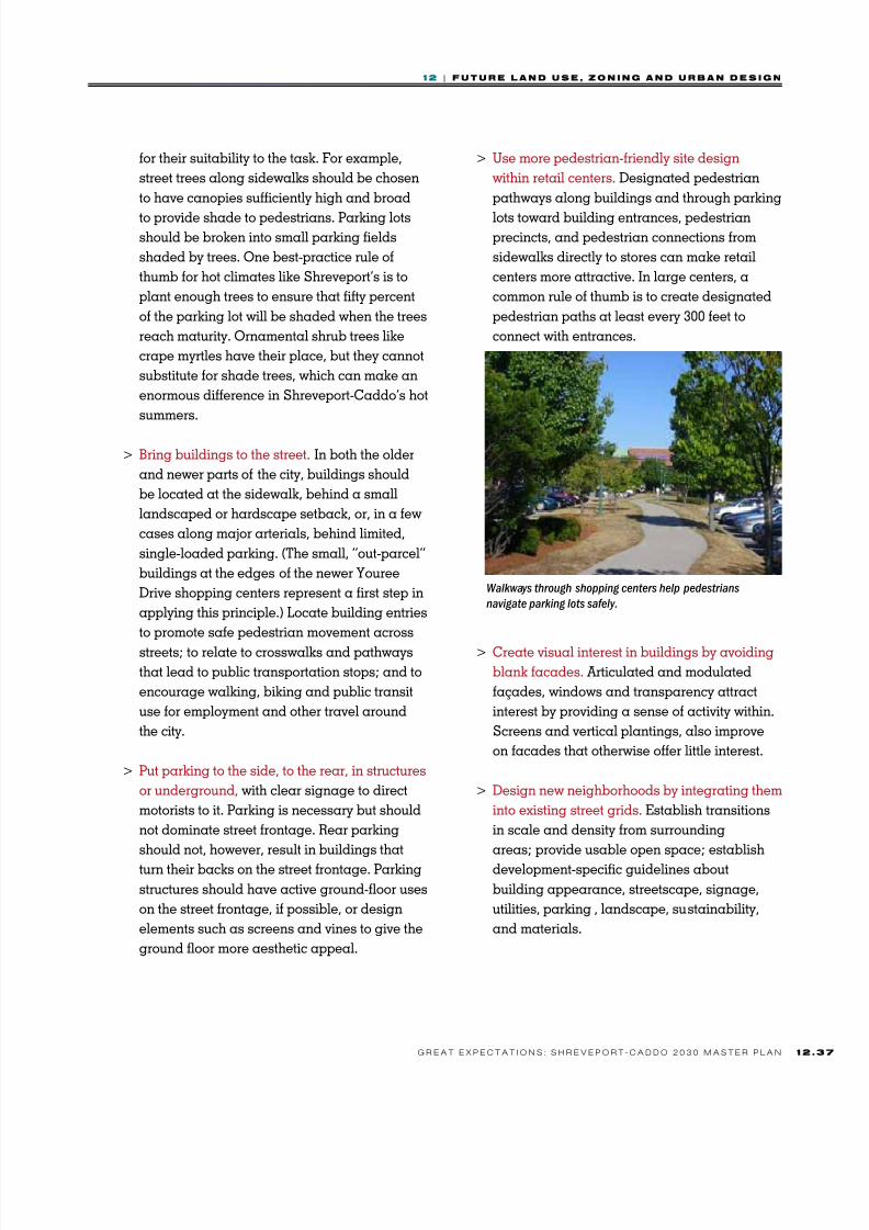
8/3/2019 CH12_101221-LO
http://slidepdf.com/reader/full/ch12101221-lo 37/40
1 2 | F u u r e n d u e , z o n n g n d u r n d e g n
1 2G r e a t e x e c t a t i o n s : s h r e v e o r t - c a d d o 2 0 3 0 M a s t e r L a n
for their suitability to the task. For example,
street trees along sidewalks should be chosen
to have canopies sufficiently high and broad
to provide shade to pedestrians. Parking lotsshould be broken into small parking fields
shaded by trees. One best-practice rule of
thumb for hot climates like Shreveport’s is to
plant enough trees to ensure that fifty percent
of the parking lot will be shaded when the trees
reach maturity. Ornamental shrub trees like
crape myrtles have their place, but they cannot
substitute for shade trees, which can make an
enormous difference in Shreveport-Caddo’s hot
summers.
> Bring buildings to the street. In both the older
and newer parts of the city, buildings should
be located at the sidewalk, behind a small
landscaped or hardscape setback, or, in a few
cases along major arterials, behind limited,
single-loaded parking. (The small, “out-parcel”
buildings at the edges of the newer Youree
Drive shopping centers represent a first step in
applying this principle.) Locate building entries
to promote safe pedestrian movement across
streets; to relate to crosswalks and pathways
that lead to public transportation stops; and to
encourage walking, biking and public transit
use for employment and other travel around
the city.
> Put parking to the side, to the rear, in structures
or underground, with clear signage to direct
motorists to it. Parking is necessary but should
not dominate street frontage. Rear parking
should not, however, result in buildings that
turn their backs on the street frontage. Parking
structures should have active ground-floor uses
on the street frontage, if possible, or design
elements such as screens and vines to give the
ground floor more aesthetic appeal.
> Use more pedestrian-friendly site design
within retail centers. Designated pedestrian
pathways along buildings and through parking
lots toward building entrances, pedestrianprecincts, and pedestrian connections from
sidewalks directly to stores can make retail
centers more attractive. In large centers, a
common rule of thumb is to create designated
pedestrian paths at least every 300 feet to
connect with entrances.
> Create visual interest in buildings by avoiding
blank facades. Articulated and modulated
façades, windows and transparency attract
interest by providing a sense of activity within.
Screens and vertical plantings, also improve
on facades that otherwise offer little interest.
> Design new neighborhoods by integrating them
into existing street grids. Establish transitions
in scale and density from surrounding
areas; provide usable open space; establish
development-specific guidelines about
building appearance, streetscape, signage,
utilities, parking , landscape, sustainability,
and materials.
Walkways through shopping centers help pedestrians
navigate parking lots saely.

8/3/2019 CH12_101221-LO
http://slidepdf.com/reader/full/ch12101221-lo 38/40
1 2 | F u u r e n d u e , z o n n g n d u r n d e g n
1 2 . 3 8 G r e a t e x e c t a t i o n s : s h r e v e o r t - c a d d o 2 0 3 0 M a s t e r L a n
> Design compact subdivisions for walkability,
diversity, and connectivity. Smaller block
sizes, averaging of lot sizes to allow for
different housing types, narrower streets,limits on cul-de-sacs and dead-end
streets, provisions for future connectivity
and dedication of open space will create
subdivisions that, when connected together,
create neighborhoods:
• Smaller block sizes (under 600 feet)
improve connectivity.
• Narrower streets slow traffic and reduce
the amount of impervious surface and
stormwater runoff. Public safety officials,
who sometimes worry about access if
streets are narrow, should be included in
discussions of alternative design standards
which can meet these concerns.
• Cul-de-sacs and dead end streets reduce
connectivity and should be limited.
• Subdivisions should be designed and built
to provide open space and appropriatelocations for future connections
> Promote sustainability. Incorporate building
elements that improve energy efficiency, such
as green roofs, rain gardens, solar panels,
wind turbines, and others wherever possible.
These elements should be scaled appropriately
and incorporated seamlessly into the overall
façade. Incorporate passive heating and
cooling mechanisms such as operable
windows, sun shades, cross-ventilation,
and adequate insulation into the design of
buildings whenever possible.
Mixed-use or commercial blocks
> Building
entrances should
be oriented to the
street.
> Blocks with
commercial uses
should have a
consistent street
edge.
> Commercial uses
in general should
be built to the
sidewalk edge
or with small setbacks of 5 to 15 feet for cafés,
benches or small open spaces. Larger setbacks
may be suitable to create plaza-like spaces that
accommodate street furniture, street trees or
wider sidewalks.
> Street-level façades should include active
uses, such as residential entrances; shops,
restaurants, and cafés; services for the public or
for commercial offices, such as fitness centers
or daycare centers; community spaces, such
as exhibition or meeting space; art exhibition
space/display windows; commercial lobbies
and front doors.
Design Principles for Mixed-Use Districts
Shops and oces on the ground foor share the building with
housing above.
A variety o business ronts on this
tree-lined block.

8/3/2019 CH12_101221-LO
http://slidepdf.com/reader/full/ch12101221-lo 39/40
1 2 | F u u r e n d u e , z o n n g n d u r n d e g n
1 2G r e a t e x e c t a t i o n s : s h r e v e o r t - c a d d o 2 0 3 0 M a s t e r L a n
> Where there are residential uses over retail,
separate street-level lobbies for residential
entrances should be created.
> Office uses should be discouraged from
occupying extensive ground-floor frontage.
> Ground floor nonresidential uses should have
clear windows to provide transparency (at least
50 percent) and provide articulation and details
to provide interest at the human scale.
> Corners
should be
emphasized
with buildings,
ideally
with taller
elements such
as towers,
turrets and
bays, or
with open
spaces that include public art, fountains, or
other attractions. Parking lots, loading areas, or
service areas should not be located at corners.
> Variations in height and architectural elements
such as parapets, cornices and other details
should be used to create interesting and varied
rooflines and to clearly express the tops of
buildings.
> Drive-through facilities should be discouraged.
If necessary, they should be permitted only at
the rear of the building.
> Awnings and canopies should be encouraged
to provide shelter and enliven ground floor
façades.
> Driveway turnaround and vehicle drop-offfacilities should be avoided because they
create obstacles and safety issues to continuous
pedestrian ways.
> Loading and other service areas should ideally
be inside the building and screened from
adjacent residential areas.
> Blank walls should be avoided along all streets
and pedestrian walkways.
Parking
> Shared parking should be encouraged instead
of on-site parking minimums for each lot;
ideally, parking should be managed for the
entire commercial district.
> Locate surface parking preferably to the rear
and secondarily to the side of buildings.
> Parking lots along the street should be small
and few in number and visually and functionally
separated from the sidewalk by walls, fencing
and/or landscaping.> Parking lots should include trees that, at
maturity, will shade 50 percent of the lot.
Streetscape
> Sidewalks should be wide enough to allow at
least two people to walk together.
> Pedestrian lighting should use low-intensity,
pedestrian-scale light standards, and distribute
light evenly, so
that there are no
areas of intense
shadows.
> Wayfinding
signage should
be created as
a system, with
simple, legible
design.
Public spaces
> Public spaces
should be
surrounded with uses that create an active environment
throughout the day and evening and increase
safety for park and plaza users. Examples
include shops, cafes and other public uses that
enliven the street.
Corners can have special elements or
emphasis.
Maps and signage should be easy
to nd and read.
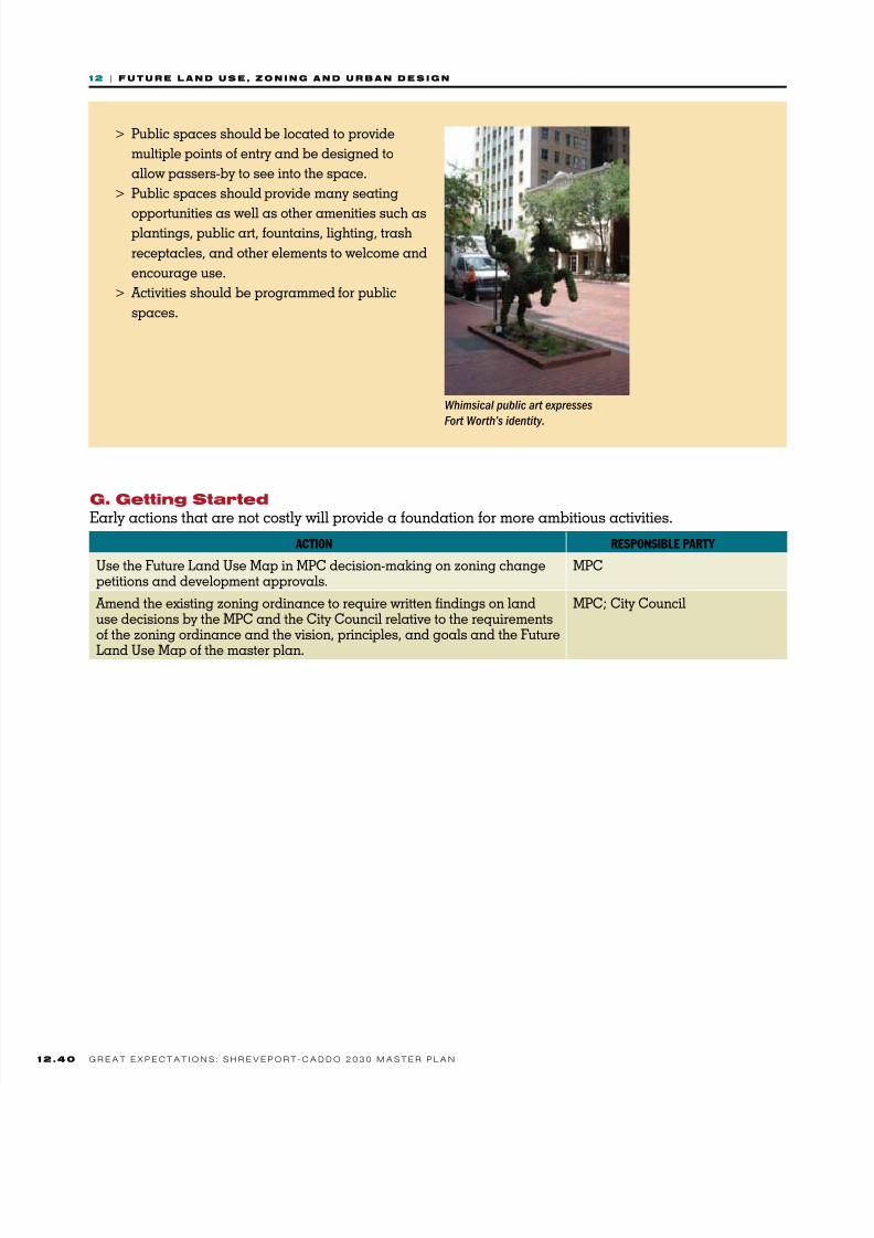
8/3/2019 CH12_101221-LO
http://slidepdf.com/reader/full/ch12101221-lo 40/40
1 2 | F u u r e n d u e , z o n n g n d u r n d e g n
> Public spaces should be located to provide
multiple points of entry and be designed to
allow passers-by to see into the space.
> Public spaces should provide many seating
opportunities as well as other amenities such asplantings, public art, fountains, lighting, trash
receptacles, and other elements to welcome and
encourage use.
> Activities should be programmed for public
spaces.
Whimsical public art expresses
Fort Worth’s identity.
ACtION RESPONSIBLE PARty
Use the Future Land Use Map in MPC decision-making on zoning changepetitions and development approvals.
MPC
Amend the existing zoning ordinance to require written findings on landuse decisions by the MPC and the City Council relative to the requirementsof the zoning ordinance and the vision, principles, and goals and the Future
Land Use Map of the master plan.
MPC; City Council
g. gtti tat
Early actions that are not costly will provide a foundation for more ambitious activities.


![[Suzanne Duvall Jacobitti] Lo Publico, Lo Privadi y Lo Moral](https://static.fdocuments.us/doc/165x107/577cd8521a28ab9e78a0f37f/suzanne-duvall-jacobitti-lo-publico-lo-privadi-y-lo-moral.jpg)