
Cgalies final V1.0 Jan Mdocbox.etsi.org/STF/Archive/STF321_TISPAN3_EC_Emergency_Call_… · Cgalies...
99
Cgalies final report V1.0 Page 1 18.02.2002 Final report. Report on implementation issues related to access to location information by emergency services (E112 ) in the European Union. .
Transcript of Cgalies final V1.0 Jan Mdocbox.etsi.org/STF/Archive/STF321_TISPAN3_EC_Emergency_Call_… · Cgalies...
Cgalies final report V1.0 Page 1 18.02.2002
Final report.
Report on implementation issues related to access to location information by emergency
services (E112 ) in the European Union.
.
Cgalies final report V1.0 Page 2 18.02.2002
Authors: Brendan Ludden Vodafone UK
Andrew Pickford Cambridge positioning systems Ltd UK
John Medland Britisch Telecommunications UK
Hank Johnson HBF group BV USA
Francois Brandon IRSM F
Lars Erik Axelsson National Post and Telecoms Agency S
Knut Viddal-Ervik Telenor N
Bert Dorgelo Lucent Technologies B.V. NL
Eileen Boroski Intrado USA
Jan Malenstein KLPD NL
This document has been prepared by C.G.A.L.I.E.S. , based on individual contributions and
plenary discussions consolidated in this document. No liability can be accepted for any statement or consequence emanating from this document
Version Date Distribution Comments
1.0 28/01/02 Cgalies plenary Final version after updates received and deadline passed.

Cgalies final report V1.0 Page 3 18.02.2002
TABLE OF CONTENTS. 1 EXECUTIVE SUMMARY.................................................................................................................. 5
1.1 CGALIES, Terms of Reference................................................................................................. 5 1. Introduction and background........................................................................................................ 5 Mission and mandate. ...................................................................................................................... 6 Support by Commission R&D projects............................................................................................. 6 Membership issues. ......................................................................................................................... 6
1.2 Questionnaire to the Member States. ....................................................................................... 6 1.3 Costs. ........................................................................................................................................ 7 1.4 Hurdles...................................................................................................................................... 8
2. INTRODUCTION AND BACKGROUND....................................................................................... 8 2.1 Enhancing the safety and security for the citizens in the Information Society.......................... 8 2.2 The EU political context ............................................................................................................ 9
3 PROBLEM DESCRIPTION .............................................................................................................. 9 3.1 Defining the location problem. .................................................................................................. 9
Fixed calls. ..................................................................................................................................... 10 Mobile calls..................................................................................................................................... 10
3.2 Other issues ............................................................................................................................ 11 112 unknown to the citizens........................................................................................................... 11 Overload......................................................................................................................................... 11 Roaming ......................................................................................................................................... 12 Technical and Operational Interoperability .................................................................................... 12 In-car mayday/emergency systems ............................................................................................... 13 Role/position of the Commercial service provider.......................................................................... 13 Private phone switches (PABX) ..................................................................................................... 13 Legal issues such as privacy and liability....................................................................................... 14
3.3 What will not be covered by CGALIES ................................................................................... 15 4 BENEFITS OF ENHANCING 112 WITH LOCATION INFORMATION.......................................... 16
4.1 Benefits for Society. ................................................................................................................ 16 4.2 Benefits for mobile and automotive users............................................................................... 16 4.3 Benefits for Emergency Service Operators. ........................................................................... 17
Network usability. ........................................................................................................................... 17 Operational usability....................................................................................................................... 17
4.4 Improved quality of PSAP operation. ...................................................................................... 18 Procedures. .................................................................................................................................... 18 Technology..................................................................................................................................... 19
5. REQUIREMENTS....................................................................................................................... 20 5.1 Location accuracy and latency................................................................................................ 20 5.2 Requirements for networks and routing, PSAPs and databases............................................ 22
Schematic Diagram........................................................................................................................ 22 112 Survey. .................................................................................................................................... 23 Organisation of Public Service Answering Points/ Emergency Service Centres........................... 23 Availability and access to Location Databases for fixed telephones ............................................. 23 High Level Requirements............................................................................................................... 24 Network Access to PSAPs or Emergency Service Centres........................................................... 24 Availability and access to Location Databases .............................................................................. 24
Cgalies final report V1.0 Page 4 18.02.2002
Conclusions.................................................................................................................................... 26 5.3 The interface between the network and the PSAPs. .............................................................. 26
6. IMPLEMENTATION OPTIONS .................................................................................................. 27 6.1 Introduction ............................................................................................................................. 27 6.2 Feasibility of technologies....................................................................................................... 28 6.3 General cost aspects. ............................................................................................................. 29 6.4 Cost assessment of mobile network implementation.............................................................. 31
Synthesis of reactions .................................................................................................................... 31 6.5 Who pays the bill..................................................................................................................... 32
7 MATCHING SOLUTIONS. ............................................................................................................. 33 7.1 Implementation scenarios. ...................................................................................................... 33
Scenario A: Market Driven ............................................................................................................. 33 Scenario B: Regulated . ................................................................................................................. 34
7.2 Migrations issues .................................................................................................................... 36 8. CONCLUSIONS. ........................................................................................................................ 37 9 GLOSSARY OF TERMS:............................................................................................................... 38 10 LITERATURE ............................................................................................................................. 40 11 ANNEXES................................................................................................................................... 41
11.1 ANNEX 1, WP 1 report....................................................................................................... 42 11.2 ANNEX 2. QUESTIONNAIRE ON THE REQUIREMENTS OF NATIONAL CIVIL PROTECTION AUTHORITIES REGARDING THE LOCATION OF CALLERS IN EMERGENCY SITUATIONS (ENHANCED 112)....................................................................................................... 78 11.3 ANNEX 3, PROPRIETY IN-CAR SYSTEMS ...................................................................... 92 11.4 ANNEX 4. LIST OF CGALIES MEMBERS. ........................................................................ 96
Cgalies final report V1.0 Page 5 18.02.2002
1 EXECUTIVE SUMMARY This document should not be perceived as a binding proposal on location information for emergency services. It is offered to the European Commission, to the European Union and its Member States, including the public and the private sector for broad consideration. Each year in the European Union, several millions of citizens dial an emergency call number to access emergency services. Due to the increasing penetration of mobile telephony in the society, the share of emergency calls emanating from mobile networks is continuously growing and the fact is that today, many mobile callers in an emergency situation are not able to indicate the precise location for a optimum response. Due to its nature, Emergency communications is particularly an area where information needs to pass across public and private sector boundaries. .
1.1 CGALIES, Terms of Reference.
1. Introduction and background. In July 2000, the Commission adopted the new proposals for the future telecommunications regulatory framework to the European Parliament and the Council (see for instance http://europa.eu.int/ISPO/infosoc/telecompolicy/Welcome.htm). As part of its proposals, the Commission wants operators to make available the location of callers in a distress situation to emergency services organisations. The Commission retained this in the legislative proposals with strong support of Governments and user associations. An increased level of safety and security which is now possible by the technology can not be achieved by compromising the principles of privacy. In this context, the Commission proposed to revise the Telecommunications Data Protection Directive which, inter alia, now includes a provision on data protection safeguards for the use of location data. Experience has shown in other parts of the World that a smooth and successful introduction of enhanced emergency services, as called for by the new regulatory proposals, cannot be taken for granted. Emergency communications is particularly an area where information needs to pass across public and private sector boundaries. Each sector will have to support the other - no one can work in isolation. For the successful implementation of enhanced 112 emergency services in Europe, a large number of issues would need to be clarified and time scales for the introduction of new systems would need to be co-ordinated. This requires a consensus between all players about the implementation details in order to achieve a co-ordinated introduction and safeguard investments in new systems. This is equally true for the public and private sectors. Accordingly, the Commission Services have initiated the Coordination Group on Access to Location Information by Emergency Services (CGALIES) as a public/private partnership between public service and private sectors to find harmonised, find timely and financially sound solutions. The Commission Services have indicated that, if CGALIES is able to find good solutions on the implementation details and time scales by consensus, it would consider a new Community measure to confirm such consensus. The Commission Services consider that the work of CGALIES complements and facilitates the political discussion in the European Parliament and the Council on the new regulatory framework. The approach is fully commensurate with the new philosophy whereby the general principles are set out in EU legislation whilst the implementation details are left as much as possible to the respective players.
Cgalies final report V1.0 Page 6 18.02.2002
Mission and mandate. The main task of CGALIES is to identify the relevant implementation issues with regard to enhancing emergency services in Europe with the provision of location information, to analyse and describe them and to build a consensus on the Europe-wide implementation, involving the views and opinions of all relevant players. In certain cases, issues are perhaps better resolved at a national level. Notwithstanding this, it might be important and appropriate to discuss them at the European level to facilitate the consensus building process. In order to accomplish its task, CGALIES has organised its work as follows: • Work Package 1:
o Minimum ‘standards’ on location data accuracy, reliability and evolution path. Minimum requirements for location reference system.
• Work Package 2: o Minimum functional ‘standards’ for routing and networks. o Minimum ‘standards’ on databases. o Minimum ‘standards’ for Public Safety Answering Points (PSAPs)
• Work Package 3: o Analysis of financing and costs and how this relates to type (and quality) of service
and other implementation issues CGALIES will produce a consolidated European view of the requirements of emergency services with its main findings and recommendations by December 2001.
Support by Commission R&D projects. The work of CGALIES may be supported through several Commission R&D projects, in particular LOCUS and ROSETTA. The work performed in these projects will be aligned with the agenda and work plan of CGALIES, if and where that is appropriate. As the work of CGALIES will have to be an iterative approach process with several parallel streams that need to interact (for instance cost and technological solutions can only be considered together), the interaction between CGALIES and these projects will need to be strengthened.
Further information about CGALIES, its mandate and its activities can be found at www.telematica.de/cgalies. Further information about LOCUS can be found at www.telematica.de/locus.
Membership issues. CGALIES will be open to anyone who may have an interest in this field. The members of CGALIES commit themselves to reaching the objectives in good time and will take the necessary steps to achieve this.
1.2 Questionnaire to the Member States. In the framework of CGALIES activities, a "questionnaire on the requirements of National Civil Protection Authorities regarding the location of callers in emergency situations (Enhanced 112)" was sent by the European Commission to the Member States. The objective of the questionnaire was to have a better understanding of the problems faced by emergency services and to assess their requirements regarding location information.
Cgalies final report V1.0 Page 7 18.02.2002
Extrapolating the responses received it is estimated that among the 40 million "real" mobile emergency calls handled by the emergency service operators each year in the European Union, considerable time is lost by emergency services during their intervention for approximately 3.5 million calls, due to the fact that the location information provided by the caller is later found to be inaccurate. It was also estimated that emergency services are not able to dispatch a rescue team for approximately 2.5 million calls, due to the absence of sufficient location information. Coming back to these statistics, it appears that automatic location information can bring important benefits for emergency service operation. The task of responding to an emergency call can be substantially supported if accurate digital location information will be available automatically with each emergency call. Next to vocal location information digital location information can be used to verify immediately upon reception the vocal information provided by the caller. Specifically regarding mobile emergency calls, the availability of automatic location information could also enable emergency services to improve capacity management. Accurate automatic location referencing is the foremost way to find out if there are multiple accidents, requiring a doubling or tripling of the emergency services deployment. Automated accurate digital location information enables the Emergency Service Operator to separate calls from the same incident site from calls from other (new) incidents. Achieving these benefits requires the network operator to determine and provide location referencing information and the emergency service operator to be able to process and use this information. In the framework of Enhanced emergency call services, the availability of location information must serve at least three aims: • Route the calls to the right emergency call centre. • Dispatch the most appropriate emergency response team(s). • Locate the caller and incident site. The requirements of emergency services do not focus only on positioning. In this document Emergency services have also formulated additional requirements on network, the emergency call centres, databases and digital mapping issues. The exchange of location estimate and other information between the Telecom Operator and the emergency call center should take place across a standardised interface. There are significant and focussed standardisation activities underway, taking into account work carried out by FCC and Cgalies, to provide this standardised interface, al least for the mobile network operators.
1.3 Costs. In addition to technology, CGALIES considered also the cost of implementation of the different technology options as the main issue and did an analysis on this. Normally, the network operator/provider bears the costs for the network infrastructure. The emergency call centres bear the costs for the physical structure like buildings, systems and the human resources, the call-takers and operators. Network service costs may be shared. For emergency service operation, using location technology, the principle is likely to be the same, provided that the costs will be acceptable for all parties involved. For the emergency call centres , costs will consist of upgrading the call taking system to be able to receive, process and present caller location information, along with the correct serving emergency response agencies for the caller's location, for both mobile and fixed line emergency calls. Commercial location services are currently entering the marketplace. Where location based services are to be deployed, the incremental cost for upgrading the systems for the automatic provision of location information to a PSAP was estimated up to10 M Euros for each network operator. However, Where location based services are not to be deployed, the incremental cost for upgrading the systems will be significantly higher.

Cgalies final report V1.0 Page 8 18.02.2002
According to a questionnaire among network operators, some operators currently plan to upgrade their networks for the provision of high accuracy location services, but strong divergence was seen in their plans. Most operators felt that the cost for implementation of the interface with the location services platform would be borne by the operator, whilst the PSAP would bear the cost of its equipment and data bases, including the cost of any functionality upgrades. Some operators however expressed a belief that, as emergency calls fall within the public service area, they should be financed by public funds (where investment costs and service costs that can be exclusively attributed to public interest service should be charged to PSAPs at rates that are valid for third parties). Two implementation scenarios have been considered in this document as benchmarks with a full market driven mechanism at the one hand and a strictly regulated mechanism at the other hand. The final recommendations made by CGALIES are positioned somewhere between those two benchmarks, and contain elements of both scenarios with a preference to the emphasis on the market driven mechanism.
1.4 Hurdles. Hurdles reflected on by Cgalies are the role of commercial service providers not being emergency service operators acknowledged by the government (police, fire brigade and ambulance) to whom emergency calls are forwarded by pushing the (in-car) emergency or SOS button, and privately owned company and industrial networks, commonly known as PABX systems. These PABX systems will not be subject to the new Telecom regulations as these only regulate the public networks obligations. It is strongly advised to consider these issues in a separate context. Another hurdle is the fact that the proposed regulation does not take into account an obligation at the EU level for emergency service operators to execute the necessary technical and operational adaptations in order to be able to process and use automatic location information. It is advised that this issue will be taken up by the Commission .
2. INTRODUCTION AND BACKGROUND
2.1 Enhancing the safety and security for the citizens in the Information Society Technologies and markets are evolving at bewildering speeds. The cellular communications market has grown dramatically. By 2003, about two thirds of all Europeans will have a mobile phone. The transition towards the ‘Information Society’ will be driven forward by commercial forces at great speed. It will deliver a wealth of new services and applications for mass market consumption. And as competition will be further increased, operators - in search for new revenue streams – will install location reference systems in mobile networks to offer enhanced services to the users. Many of the multimedia services offered will be location dependent i.e. the service offering will change as we move along the highway or roam in the foreign country. Statistics indicate that more than 90 million European citizens travel abroad at least once a year where over 65 % of them feel insecure or unsafe when they are on travel; and a relatively large percentage of mobile callers do not know where they are when they make an emergency call. With over 250 million GSM phones in use in the European Union, the challenges for emergency services are huge and increasing.
It will be the responsibility of the public authorities to ensure that technology and market developments will not only benefit commercial players but will also benefit the citizens by enhancing their safety and security. It must be their aim to create a safer Europe; and employ the technologies that are "available today" for doing so. It would be a fundamental mistake if advanced commercial location services were to be widely available but if critical location data could not be passed on and used to enhance the provision of emergency services.

Cgalies final report V1.0 Page 9 18.02.2002
2.2 The EU political context
The common emergency number ‘112’ is slowly becoming more successful as it makes inroads into Europe’s societies. But progression is still slow and the situation is falling short from where it should be. In this context, e-Europe proposes ambitious short term targets to bring the benefits of the Information Society within reach of all Europeans.
The e-Europe action plan was endorsed at the European Summits in Lisbon and Feira in 2000, where EU leaders made a strong commitment to ensure that Europe catches up in the Information Society. As part of the proposals, all citizens on the move throughout Europe should have full access everywhere to multilingual support; and emergency call localisation should be the norm as well as the fully organised provision of emergency services through the 112 number.
This links with the EC proposals for the new telecommunications regulatory framework to the European Parliament and the Council1. As part of its proposals that were adopted by the Commission in July 2000, the Commission wants operators of public telecommunications networks to make available the location of callers dialling the EU emergency number 112.
An increased level of safety and security which is now possible by the technology can not be achieved by compromising the principles of privacy. The capacity of processing very precise location data in mobile communications networks should not lead to a situation where mobile users are under permanent surveillance with no means to protect their privacy, other than not using mobile communications services at all. In this context, the Commission proposed a revised Communications Data Protection Directive, which provides for a right to override the restriction of location data collection and processing for emergency 112 calls and the tracking of malicious and nuisance calls.
3 PROBLEM DESCRIPTION
3.1 Defining the location problem. Each year in the European Union, several millions of citizens dial an emergency call number to access emergency services. Due to the increasing penetration of mobile telephony in the society, the share of emergency calls emanating from mobile networks is continuously growing and the fact is that today, many mobile callers in an emergency situation are not able to indicate their location. Such a situation makes the task of emergency services extremely difficult since their efficiency, and in particular their response time, are dependent on their knowledge of the caller's location. In the framework of CGALIES activities, a "questionnaire on the requirements of National Civil Protection Authorities regarding the location of callers in emergency situations (Enhanced 112)" was sent by the European Commission to the Member States. The objective of the questionnaire was to have a better understanding of the problems faced by emergency services and to assess their requirements regarding location information. Eleven Member States representing almost three quarters of the European Union in terms of inhabitants, responded to the questionnaire mentioned above. The statistics provided have been extrapolated in order to obtain a good overview of the emergency call landscape at a EU scale. These Member States provided valuable information about emergency call services (statistics about the number of calls per year, the percentage of mobile calls, etc.) as well as about their requirements concerning the quality of service of Enhanced emergency services. Considering that the statistics provided by the Member States are representative of approximately 180 million citizens, it is beyond doubt that they enable to draw a picture of the general situation. The statistics mentioned above have therefore been extrapolated in order to obtain a good overview of the emergency call landscape at a EU scale. The results of this extrapolation are presented hereafter. 1 (see for instance http://europa.eu.int/ISPO/infosoc/telecompolicy/Welcome.htm)

Cgalies final report V1.0 Page 10 18.02.2002
According to the extrapolated responses to the questionnaire, more than 185 million calls are received by Public Safety Answering Points (PSAPs) each year in the European Union. Among these calls, approximately 80 millions are treated as "real" emergency calls, the other ones not being related to any emergency situation: people looking for information, people testing a mobile phone (emergency calls being the only calls that can be placed even without a SIM card), children's play, etc. The general public (including and especially children) should be educated that dialling 1-1-2 is for emergencies only. Any country with more than one emergency number should adopt only the number 1-1-2 for any and all emergencies. Among the real emergency calls, approximately 40 million calls (~50%) emanate from mobile phones (in some countries, the percentage of mobile calls is even close to 70%).
Fixed calls. Most, if not all 1-1-2 systems deployed in the EU do not properly verify a telephone’s address location prior to sending it to a Psap. A location should be verified during the call, not after. Telephone locations are not compared via computer software to the maps (Master Street Address Guide, or MSAG) used by the emergency service providers of the area being served by a 1-1-2 system. For fixed (landline) telephones the address (both tabular street address and X and Y coordinates) location and telephone number, as well as routing information and serving agencies is stored. There is no automatic location information (ALI) or MSAGs used in any European country, therefore a great deal of bad location information exists in the fixed line databases. Master Street Address Guides (MSAGs) must be established for fixed lines to compare telephone locations from the Operators to the MSAGs. These MSAGs must be both tabular (physical streets and boundaries) and spatial, with X and Y coordinates of all Emergency Serving Zone (ESZ) boundaries included. This will accommodate routing of calls to the proper PSAP. Because this is not being done, location errors are guaranteed to occur, and citizens will suffer loss of property and injuries or death that is unnecessary. The databases often do not include private numbers, and in fact, most systems only have “directory” published numbers and locations in them. Most of the databases are not updated with adds, changes and deletes but once a month, therefore, untold numbers of telephone locations are not correct, or are not in the database at all. An Automatic Location Identification (ALI) database, to qualify as Enhanced, must be updated in real time as changes occur, or at least, every 24 hours. In addition, PBX stations are not in databases. Most systems do not have Automatic Location Identification (ALI), as the location of the fixed caller has to be “pulled” from the database, wasting precious time, and introducing the possibility of an erroneous telephone number being keyed, such will result in a wrong address being displayed. Standards must be developed for:
• the formats for data exchange among Operators to various databases, • display formats for PSAP screens, • protocols for selective routing of calls to the proper PSAPs, • communications protocols for data from databases to the PSAPs, • PSAP equipment and features, such as ring back, call transfers, alternate routing in case of
too much traffic, what emergency service agencies are to be displayed at the PSAP, etc.
Mobile calls The situation for mobile calls is also critical. Among the 40 million "real" mobile emergency calls handled by the PSAPs each year in the European Union, considerable time is lost by emergency services during their intervention for approximately 3.5 million calls, due to the fact that the location information provided by the caller is later found to be inaccurate. Moreover, the emergency services are not able to dispatch a rescue team for approximately 2.5 million calls, due to the absence of sufficient location information. Last but not least, it must be noted that according to the Civil Protection Authorities, the automatic availability of location information would enable emergency services to save from a few tens of seconds up to a few minutes for the intervention time related to the remaining 34 million calls.

Cgalies final report V1.0 Page 11 18.02.2002
Coming back to the statistics related to mobile emergency calls and presented above, it appears that today, the availability of automatic location information can be considered as essential for all emergency calls. For the routing of mobile 112 calls a tabular MSAG – which does not support the needs of the mobile users – is not the appropriate solution. A geographical based routing system would be the solution. In a geographical routing system all fixed telephony addresses are geocoded with an x/y assigned to each address. Mobile emergency calls will be x/y position based. In this manner all emergency calls are routed using the same technologies. Since most of the EU is Common Channel Signaling System 7 supported, the SS7 architecture should be utilized for 112 call routing purposes. Using SS7 instead of deploying Selective Routers, offers several benefits. First all calls – fixed and mobile – can be routed using the same technology. Second call set up and tear down is faster with SS7 than Selective Routers. Lastly, the telephone operator is spared the expense of deploying special technologies (Selective Routers) purely for emergency calls. Alternate Routing, default routing and call transfer can all be accommodated using an SS7 architecture. Location based call routing in the wireless network is required in order to achieve this.
3.2 Other issues
112 unknown to the citizens The situation depicted above covers emergency calls in general, regardless if these calls are placed through the European emergency call number (112) or through the other national emergency call numbers still operating in most of the Member States. Very few statistics are available concerning the percentage of emergency calls placed using 112, and the responses to the questionnaire do not clarify the situation since only three Member States provided figures concerning this specific issue and these figures vary from 12% up to 97%. However, it is more than probable that 112 calls do not represent a high share of the total emergency calls: the results of a survey presented during the "112’s Implementation for European Citizen" workshop held in Luxembourg in May 2000 show that 112 is generally not well known by European citizens. According to this survey, the percentage of European citizens that would use 112 in an emergency when travelling abroad represents only 19.2%. The survey also indicates that 41.3% of European citizens do not know at all what emergency number they could dial in a similar situation. At the same time, 65.2% of the European citizens travelling abroad indicate they feel less protected than in their own country. This low awareness about 112 is not very surprising when one knows that for the time being, only two Member States have established 112 as being the only emergency call number, and that in the other Member States, 112 co-exists with one, two or even 3 other national emergency call numbers. Moreover, the basic public emergency services which are accessible through 112 all over the European Union are generally the police, fire fighters and medical emergency services, but the emergency services accessible through 112 are not always limited to the three services mentioned above. Other services like "search and rescue", poison information, nurse on duty, midwife on duty, etc, can also be available depending on the Member States. This kaleidoscope of numbers and available services probably contributes, together with the lack of information campaigns, to the general unawareness of the European citizens concerning 112. This must be changed, and all member states must adopt the number 1-1-2 for all emergency services and educate all citizens of its existence and to use it for emergencies only. If only the number 1-1-2 is used in all countries, then Europeans will not hesitate to use it no matter in which country they are travelling.
Overload Combined with additional applications, location and velocity (i.e., direction and speed) information can be used to identify if multiple calls refer to the same incident or not, or to determine if a call is made by a “Good Samaritan”, provided it can be distinguished if a call is associated with a moving vehicle Today’s experience shows that callers in more than half of the cases cannot give an exact location reference for the incident to report on, which is mainly due to the fact that one didn't stop at the scene of the incident but simply drove on and made the report later on. This makes it time-consuming to find out if the call refers to a known incident or if it concerns a "new" incident.
Cgalies final report V1.0 Page 12 18.02.2002
In addition to the main aims mentioned above, the availability of automatic location information could enable emergency services to fight against call handling capacity problems. The number of calls received by PSAPs has been increasing during the last years, as illustrated for instance by the police emergency calls placed in Berlin during the last ten years: statistics show that the number of operations has been staying stable while the number of calls has been multiplied by more than two. This increase of redundant calls, or "good Samaritan" calls, is a direct consequence of the high penetration of mobile phones in the society: contrary to ten years ago, many people have now a mobile phone and can immediately call emergency services when they witness an incident. This multiplication of redundant calls (up to several tens of calls for a same incident in some cases) can lead to an overload of PSAPs. Filtering redundant calls (assuming for instance that the calls placed at the same time in a same limited area relate to the same incident) could contribute to prevent PSAPs from overloading. The filtering function should be the responsibility of the PSAPs. In addition, proper selective routing of the calls to the proper PSAP with the correct serving agencies for the caller’s location would save many lives, property, resources and money.
Roaming In the framework of Enhanced emergency call services, the caller's location should be determined by the network operator and then transmitted to the right PSAP. It is clear that this function should not be limited to the subscribers of the concerned operator, but should also be offered to roamers (who are more than 90 million per year in the European Union), either with the same quality of location service or with a guaranteed minimum quality of location service. The provision of uniform Enhanced emergency call services therefore requires a high level of interoperability. This interoperability must be reached between handsets and networks (e.g. when the location determination requires an active participation of the mobile), between operators' infrastructures (e.g. in order to exchange location information related to roamers).The interfaces between networks and PSAPs, and between different PSAPs (e.g. to route a call together with location information from a PSAP to another), also require defined protocols at the earliest opportunity in order to enable PSAPs and their suppliers to prepare. To address the problem of callers in one country connecting to a network in a neighbouring country’s network the transfer of calls, caller information and location between PSAPs across borders needs to be supported. The call must be routed to the PSAP with the proper emergency service agencies that serve the caller’s location. All routing should be set up in advance of cutting a live system, so that routing is automatic and no decision has to be made at the PSAP, i.e. whichever PSAP gets the call handles the dispatching or transfer of the call. The emergency agencies associated with the PSAP are always automatically displayed, along with the location of the caller. There needs to be a high level of confidence in the indicated location before it is routed to a PSAP. This requires co-operation between PSAPs that share border regions.
Technical and Operational Interoperability Furthermore, interoperability should not be limited to systems but could be extended to human beings: due to the number of languages spoken in the European Union and to the number of travellers, it would be desirable that PSAPs support several languages. In this perspective, it would be desirable that the operator inform the PSAP about the language preferences of the subscriber, if available. However, the transmission of the language preferences (or of any other personal information) to PSAPs has not been resolved yet, neither from a technical point of view, nor from a legal point of view. Proper caller automatic location would solve some of the language problems, because the PSAP would at least know where the caller is, and dispatch police to investigate the incident. Another aspect of interoperability is that the PSAP network operator interface should be standardised across the EU. The interface between PSAP and network operator will be standardised. It is the responsibility of the PSAPs in the member states to use this interface. The necessary interfaces should be defined at the earliest possible opportunity to enable PSAPs and their suppliers to prepare. If the SS7 network is used to route emergency calls, tables must be established containing call routing information. These tables can also include the preferred language of the calling party. This information can be relayed to the PSAP using standard TCAP message sets.
Cgalies final report V1.0 Page 13 18.02.2002
In-car mayday/emergency systems The Introduction of proprietary in-car systems to generate emergency calls, either manually by pressing an emergency or SOS button or automatically, being triggered by sensors, will contribute to complicating the requirements of the emergency services beyond that achievable by handheld devices, there are benefits to gain, but also disadvantages to reflect on. The benefit to gain is the possibility to have a more accurate positioning by using GPS in rural, suburban and urban areas. Additional benefit may be gained by hybrid solutions using satellite navigation and network based solutions. Another benefit seems to be the fact that additional data will be available but it remains to be seen how useful this is to standard PSAP operation (type of system; vehicle ID; vehicle data; crash impact sensor(s) data; number of persons; hazardous goods data; “other" data to be defined or to emerge in the future. If it is going to be intended to implement these data on a Pan European scale, at least a common data format and a kind of consolidated data dictionary has to be defined; otherwise these data will exist only as propriety data for each different system. Additional data need to be standardised! If vector data is collected by the Telematics devices installed on automobiles, this information can be quite useful for emergency responders including those on the scene and the trauma center accident victims are transported to for care. Provisions should be set for the collection and delivery of vector data to all emergency respondents.
Role/position of the Commercial service provider. Another aspect to reflect on will be the role of the service provider, not being an emergency service operator acknowledged by the government, to whom emergency calls may be forwarded by pushing the emergency or SOS button. It should be very clear to a user whether 112 is dialled on pushing an emergency/SOS button or that another phone number will be used to connect the user to the service desk. There are two more issues that need to be addressed as well. The first is the capacity of operating/computer systems of service providers. As lessons from the past have already been learned on this it should be an absolute demand that on the issue of responding to emergency calls by private service operators, the capacity of systems and human resources always must be able to cope with unusual circumstances like disasters, overall bad weather conditions seriously affecting road traffic and other unforeseen conditions that may cause extremely peaks in emergency communications. It will not be acceptable that citizens are faced with the fact that there simply will be no response at all on an emergency call because of insufficient capacity to handle or to process incoming emergency calls. This equally applies to the forwarding end to standing emergency service operators of a first reception front end commercial service provider. The second issue is also arising from lessons learned in the past by emergency service operators. It concerns the fact that it has proven to be absolutely necessary to train emergency service operators to handle persons in distress. On many occasions it will be experienced that people in distress will not be able to provide comprehensible information or need to be re-assured in order to prevent situations worsening. Operators will have to be trained on this, next to the ability to handle foreign languages, this is a very under estimated subject. The rules under which commercial service providers fall will need to be clarified. In the USA, the FCC has ruled that these two items should be fully covered by commercial service providers. It is the responsibility of the government to train PSAP call takers, as in almost all cases, the calls are taken by government personnel.
Private phone switches (PABX) It is common use that large organisations and companies install and operate private phone switchboards at their premises and operate proprietary security and/or emergency services. In large networks, "industrial sites", requirements from the insurance side exist. Compliance with such requirements is implemented on private basis, which is appropriate in general and is in particular reasonable for sites, that have internal emergency services.
Cgalies final report V1.0 Page 14 18.02.2002
There is an obligation to be able to handle emergency calls internally but: • Employees are located on different floors and in different buildings. • Often the buildings are not situated on at location but may be scattered throughout a city (e.g.
the buildings of the European Commission in Brussels with about 10.000 employees). These topologies present challenges for emergency response if additional location information is not made available to emergency services. Often large organisations use proprietary emergency numbers and a large part of internal emergency calls can be handled by the company's propriety security/emergency service but the major exception on this will still be the fact that if police, ambulance or fire brigade is needed, 112 will still be the only appropriate number again. The CLI (telephone number) presented at a 112 PSAP will be that of the public outgoing line at the site/building where connection is made between the private network and the public network. The public network operator will only have records of where this line is located, and not of where all the private station lines terminate, which as mentioned above can often be at other buildings/sites (without their own connections to the public network) and can be altered by the managers of the private network without informing the public network operator. The above scenario does not have to be the case, as the users of PABXs can indeed populate the database with the locations of all extensions, and send this location information to the ALI databases. So, when someone behind a PABX dials 1-1-2, the extension number and location will be displayed at the PSAP, along with the emergency serving agencies for the particular location. It is not clear to what extent legal obligations exist for organisations and companies on how to handle emergency or 112 calls, but it is strongly advised to consider these issues in a separate context . This should happen as part of the normal CLI data flow wherever possible.
Legal issues such as privacy and liability The possibility to determine the location of an individual who carries a mobile phone will raise important privacy questions. Besides the user, who may be directly affected, the mobile communications industry in Europe is greatly concerned about this issue as any mismanagement could jeopardise the achievements that result from long time commitments of the industry to guarantee users a high degree of data protection.
European law requires that the privacy of individuals is adequately protected with full control by the user. In a proposal for the new regulatory framework, an exception might however be made for emergency services that would have an override possibility, allowing them to determine the location of a victim in an emergency, even if this would be against the specific instruction of the user.
The privacy of the individual must not be compromised by the development of new functions. It is therefore important that all parties involved in the service chain of an emergency call, including emergency service organisations, respect the same privacy rules and ensure the provision of the right level of privacy protection. This requires that adequate firewalls and protocols are implemented and maintained.
A number of other legal issues will also need to be considered, among which liability in case of failure of the positioning function, management and ownership of databases containing location data, traffic data or personal data, participation of the private sector for the provision of public services, etc.
Cgalies final report V1.0 Page 15 18.02.2002
3.3 What will not be covered by CGALIES It is important to recall that CGALIES will only focus on the location referencing (and its implementation issues) to be implemented for 112 operation as foreseen in the new regulatory framework on Telecommunications. Cgalies will make a set of recommendations to the European Commission on these location referencing implementation issues, but it will not carry out the implementation itself. That trajectory is to be initiated after the Commission has studied the Cgalies recommendations and has developed initiatives accordingly. Nor will Cgalies take up the necessary physical and technological adaptations at the PSAP side on a EU scale. It should be noted however that standards MUST be set for the EU Psaps. If no standards are defined or will be implemented, there is the risk that nothing will work. CGALIES has defined standards for PSAPS (documented in this report) in relation to automatic location information; it is strongly advised to take these into account on the further trajectory of implementing enhanced 112 in Europe. Cgalies will not address other location based services, whether commercial or not.
Cgalies final report V1.0 Page 16 18.02.2002
4 BENEFITS OF ENHANCING 112 WITH LOCATION INFORMATION
4.1 Benefits for Society. The societal benefits of improved emergency help can be significant. The benefits resulting from the faster and more efficient provision of emergency help, may have positive consequences for the victims. For instance, a study in Germany estimates a considerable societal saving 2 by an improved emergency service and the speed of rehabilitation. Furthermore, various incident management studies have proved that rapid and adequate response to an incident is the most effective way to reduce traffic delays. Accurate automatic location referencing is the best way to know where emergency vehicles should be sent. Also accurate automatic location referencing is the foremost way to find out if there are multiple accidents, requiring a doubling or tripling of the emergency services deployment. Congestion costs are known to be high in all European countries, the contribution to these costs by incidents is significant. Accurate and timely location referencing can contribute to the reduction of these incident costs. Note that these savings require a co-ordinated response implying that all stakeholders can work with the location reference information.
4.2 Benefits for mobile and automotive users. The often underestimated but extremely relevant benefit of location information in case of an incident or accident is the sense of security and thus comfort it gives to users. The development of in-car “Mayday” systems started with investigations into accidents statistics in the USA. They showed a great discrepancy between hospitals in different locations. Closer analysis showed that a lack of effective emergency medical response explained these differences. In the case of traffic accidents 20 – 40% of the seriously injured victims require medical attention within the first 2 hours to survive. Medical personnel named this the “golden hour”. In this period the accident must be reported, located, and responded to. A variety of tests have been conducted in the USA to improve the probability of survival in a traffic accident; including satellite-based communication links from EMS personnel to the operating theatre. Results of pilot trials with Mayday systems that included Automatic Incident Reporting (AIR) and Location Reference (LR) convincingly demonstrated the feasibility, effectiveness and information requirements of such systems These trials showed clearly the benefit of automatic location information to enhance survivability after suffering a traffic accident. This will apply equally to other accidents if automatic location information will be available in the near future.
2 Automatisches Notrufsystem, Positionpapier des Zentralverbandes Electrotechnik- und Elektrotechnikindustrie e.V., 1999
Cgalies final report V1.0 Page 17 18.02.2002
4.3 Benefits for Emergency Service Operators. The usability of Location information depends not only on the accuracy but is also determined by each stage of a 112 call, described hereafter
Network usability. The initial stage of a 112 call is the routing through the network. Here digital location information shall be used to route the call automatically to the proper PSAP as has been defined in Workpackage 2. All calls must be routed based upon the relationship between the caller’s full telephone number (all digits) and the Emergency Service Zone number. An Emergency Service Zone (ESZ) is a unique geographical area that is served by a specific set of law, fire and EMS emergency service agencies. For mobile calls the cell and sector ID in most cases may be sufficient to route a call to the appropriate PSAP which in turn may have to forward the 112 call to the appropriate Stage 2 PSAP (the Emergency Service Control of the required emergency service operator like police, fire brigade or ambulance service that dispatches the response. However, cell coverage areas range in size from about 100 metres up to 30km, and this will again not always ensure delivery to the correct stage 1 PSAP near the edges of cell coverage areas. It should also be noted that using sell site and sector for routing emergency calls is not always sufficient because of the fact that cells and sectors may (and will) overlap Emergency service zones and PSAPs. Instead of this, X and Y coordinates of the caller should be used. If it turns out that automatic routing is required to the lowest possible geographic level of an emergency response unit, then again cell ID will not be sufficient as the radius of a cell site varies from 100 meters to 30 kilometres, and Emergency Service Zones will almost always overlap the radius. A higher accuracy location estimate will be required. The usability can be further enhanced by the quality of the location databases used by the PSAPs and the quality and accuracy of the (digital) maps being used by the Telecom operators and PSAPs. Lower accuracy locating references, i.e. Cell ID will not be accurate enough to be used in the operational response from a PSAP or emergency service to a 112 call when high accuracy is required, and therefore, effectiveness of existing PSAP responses would be diminished by not having access to a higher accuracy locating reference. Cell ID ranges from the size of a small community to a few hundred metres in Urban areas and compared to the mostly sufficient accuracy of vocal location identification there will be no added value. Even if vocal location information cannot be obtained, the areas to search will often be too large for a proper emergency response. For the operational response, the accuracy requirements are much higher, these requirements have been detailed in the section on accuracy. Usability depends also on the format of the location information. The highest possible usability will be obtained if the format of the location information allows it to travel through the entire network, through different interfaces, up to the end of the 112 chain, which is a display in the mobile response unit, still being able to display the original location information in a sufficient accurate manner.
Operational usability. Another aspect of usability is the operational use of the information. The task of responding to an emergency call can be substantially supported if accurate digital location information will be available automatically with each emergency call. This will improve the quality of overall response times to accidents. A very necessary and perhaps mandatory condition for this will be the implementation and use of a GIS, presenting the actual location immediately to the call taker. Next to vocal location information digital location information can be used to verify immediately upon reception the vocal information provided by the caller. This is the first check but at the same time it will enable the operator to interrogate the caller for the right location in case there is an instant mismatch between vocal and digital location information. The downside of the rapid proliferation of mobile phones is that there will be more and more callers per incident, this is already a very specific issue of mobile 112 calls versus fixed line 112 calls.
Cgalies final report V1.0 Page 18 18.02.2002
Thanks to automated accurate digital location information the Emergency Service Operator will be able to separate calls from the same incident site from calls from other (new) incidents. Combined with additional applications, location and velocity (i.e., direction and speed) information can be used to identify if multiple calls refer to the same incident or not, or to determine if a call is made by a “Good Samaritan”, provided it can be distinguished if a call is associated with a moving vehicle Today’s experience shows that callers in more than half of the cases cannot give an exact location reference for the incident to report on, which is mainly due to the fact that one didn't stop at the scene of the incident but simply drove on and made the report later on. This makes it time-consuming to find out if the call refers to a known incident or if it concerns a "new" incident. The direction and speed information of Good Samaritan calls can also be used to pinpoint the location of the incident, similar to dead reckoning in aviation (bearings from different positions and fixes). Knowing that a call comes from a “known incident” site allows for a much faster dealing with “good Samaritans” calls. With an average of 40 calls per incident the value of sorting this out will be obvious. However, this will require consistent accuracy readings, allowing logic to be applied to extrapolate, based on repeated location information requests to the ‘Good Samaritan’. Lower accuracy locating references such as Cell ID do not allow this consistency. This method will greatly affect the dimensioning characteristics on a operator system for ‘peak incident performance’ Automated higher accuracy Location Referencing mechanisms, therefore, not only allows the Emergency Services to increase the dispatch quality, it may be the only way to cope with the overload of emergency calls from good Samaritans. Note that these benefits require the implementation of facilities to process the location referencing information. Introduction of automated digital location referencing will have an indirect but relevant benefit. Proper European guidance and standards can reduce the costs substantially. It will simplify the co-ordinated operations of various Emergency Services thanks to the use of one unambiguous location reference. Which can only be the case if the introduction of automated digital location information has the consensus of all stakeholders.
4.4 Improved quality of PSAP operation.
Procedures. There are three stages of an emergency call, all of which have different requirements on location accuracy; initial call routing, routing for the purpose of dispatch and locating the caller. The accuracy requirements for each phase are described below:
(a) Call Routing. Fixed or land-line calls must be routed by the caller’s line number (all digits), which corresponds to a specific Emergency Service Zone number that has law, fire and EMS assigned to service the area. For mobile calls, the minimum routing to a PSAP must be cell site and sector, but far more accurate are the geo-coordinates of the caller. (b) Dispatching of emergency request to relevant service and station. The approximate accuracy requirements for dispatching a mobile emergency call to the correct service and station (2nd stage PSAP) based on the estimated location of the caller are 500m in urban areas, 5km in suburban areas, and 35km in rural areas. Cell ID and sector will be sufficient for a part of the dispatching but more accurate technologies will have to provide for a near 100% accurate routing. Due to the political issues related to dispatching emergency call requests to the correct PSAP in cell areas that may share geographical borders, it would be misleading to present accuracy requirements for this stage of an emergency call procedure.

Cgalies final report V1.0 Page 19 18.02.2002
(c) Location of caller and/or incident. Depending on the existence of a location estimate and location information provided directly by a caller we can identify three distinct means of locating the mobile caller: 1. The caller could simply provide location information verbally (although this would be regarded
as unverified). 2. The caller participates but a location estimate is available. In this case the desired accuracy of
the location system is 25m-150m for calls originating from urban areas, 50m-500m for suburban areas, 100m-500m for the rural environment and 100m-500m for motorways or waterways. 3
3. The caller is unable to provide location information, due to the inability to speak, but a location estimate is the only available source of caller’s location. In this case the desired accuracy needs to be improved to 10m-150m for urban areas, 10m-500m for suburban areas, 10m-500m for rural areas and 10m-500m for motorways or waterways.
Verification of location information provided by a caller is, of course, desirable for all emergency calls. In this case the positioning accuracy for verification is identical to that required for the handling of call clusters. Finally, the caller’s location needs to be referenced to a local map for emergency services to be delivered. In general 10m map accuracy is required – consistent with current map availability.
Technology. Interoperability is when different manufacturers’ equipment is able to function correctly and without modification, with other manufacturers’ equipment. This aspect is important to many operators that have infrastructure provided by a number of different manufacturers. If the handset location capabilities match the location capabilities of the visited network then the visited network shall provide the same Quality of Service (Qos) as the home network. If the mobile handset location capabilities do not match the location capabilities of the visited network then a minimum Quality of Service (Qos) must be guaranteed which is cell and sector ID. It is important to ensure that all calls are routed to the correct emergency service (geographically) to optimise speed of response. For roaming callers, it should be ensured that each network will provide the same level of service as to “native” customers. Roaming callers should receive maximum capability provided, depending on the limitation of the terminal. This scenario will be common during initial deployment of location services in member states. Equally, during initial deployment the location capabilities of the home network may vary according to rollout. A mobile network operator shall provide a minimum Quality of Service (Qos) to all EU subscribers (home or visiting) on its network for Emergency Location Services. The minimum QoS shall be cell and sector ID, possibly upgrading to cell and sector ID+TA later. For the more advanced methods of location the handset location capabilities are contained in the handset classmark. Due to the number of languages spoken within the EU and the extensive travelling that EU citizens do it is desirable that more than one language of the member states is supported at the PSAP. It may be desirable for the operator to inform the PSAP of the language preferences of the subscriber, if available, subject to clarification on regulations. However, the transmission of personal information to the PSAP has not been resolved. One feasible option for this could be the use of the country ID of the caller which is transmitted always as the first digits of the number string of GSM phones and which is used by the telecom operators for roaming as well. At least this is a first indication of the origin of the calling handset, acknowledging that it will not be a 100% guarantee on the user's language preference. 3 WP 1 report Cgalies.
Cgalies final report V1.0 Page 20 18.02.2002
In the framework of Enhanced emergency call services, the availability of location information must serve at least five aims:
1. Route the calls to the right PSAP. This is particularly important for calls placed near border areas (either borders between two different countries or borders between two different administrative districts of a same country) since emergency service jurisdictions and the distribution of mobile telecommunication networks are generally not the same.
2. Dispatch the most appropriate emergency team 3. Locate the victim. 4. Location of possible response. 5. Shortest routes to respond (real time AVL and traffic.
These different aims have different requirements in terms of expected quality of service, the most demanding requirements being those associated to the accurate and reliable positioning of the victim.
5. REQUIREMENTS
5.1 Location accuracy and latency A questionnaire was sent by the European Commission to the Member States in December 2000. This enabled CGALIES to obtain valuable information about the requirements of emergency services regarding the provision by operators of mobile caller's position. Emergency services requirements were also addressed in the framework of CGALIES WP1 activities. The present section provides a synthesis4 of the replies. Considering that emergency authorities were not largely represented in CGALIES, the requirements introduced hereafter must be considered as preliminary. These requirements do not concentrate only on "accuracy" but take into account a set of parameters enabling to better specify the expected Quality of Service. Most of these parameters relate to positioning requirements, but some of them also relate to communication requirements and to the operation of the service. As it is recognised that requirements are not depending on the emergency service (Police, Fire Brigade, ambulance), no distinction is made between the requirements of these different services. On the contrary, requirements are very depending on the environment (rural, urban) and on the situation (ability of the caller to provide information, visibility). The first general requirement of emergency services is that it must be possible to obtain the caller's position, with the QoS specified hereafter, each time an emergency call is placed with a mobile from anywhere in the area covered by the network. Concerning the requirements related to horizontal accuracy of the estimated position, it is necessary to make the distinction between three different levels of requirements. They corresponds to the requirements related to: • "Call routing", i.e. requirements associated to the determination of the appropriate emergency
response centre the call must be routed to. • "Dispatching", i.e. requirements associated to the determination of the appropriate local
emergency team to be dispatched by the emergency response centre. • “Caller finding", i.e. requirements associated to the "accurate" determination of the caller's location
to enable the local emergency team to find the victim as quickly as possible.
4 A more detailed specification of these requirements is available in Deliverable 2 from the LOCUS project (www.telematica.de/locus) and WP1 report CGALIES (www.telematica.de/cgalies)
Cgalies final report V1.0 Page 21 18.02.2002
The requirements associated to the two first levels are summarised in the following table: Urban Suburban Rural "Mobile Call routing" requirements ~ 1 km ~ 10 km up to ~ 35 km The requirements associated to "Mobile Caller finding" are the most demanding ones. Two additional environments have been considered for specification (Indoor on the one hand and highway/crossroads on the other hand), as well as two different cases: "Caller can provide general information about his location" on the one hand, and "Caller cannot provide any information" on the other hand (it must be noted that according to the statistics provided by the Member States, this latter case represents approximately 6% of mobile emergency calls). The requirements obtained through the questionnaire are summarised in the following table (the figures indicated between parenthesis correspond to the requirements originating from CGALIES): Indoor Urban Suburban Rural Highway
Crossroads Caller can provide general information
10 - 50 m
10 - 50 m (25 - 150 m)
30 - 100 m (50 - 500 m)
50 - 100 m (100 - 500 m)
20 - 100 m (100 - 500 m)
Caller cannot provide any information
10 - 50 m
10 - 50 m (10 - 150 m)
10 - 100 m (10 - 500 m)
10 - 100 m (10 - 500 m)
10 - 100 m (10 - 500 m)
The caller's position mentioned above must be available within 30 seconds of call initiation. In addition to this accurate positioning information, emergency services indicate that it can be useful for an emergency centre to receive as quickly as possible a first rough estimate of the caller's location (and to receive later the accurate positioning information mentioned above). According to the responses to the questionnaire, the required accuracy for this initial positioning information is generally situated between 200 and 300 m (for all environments). This initial position should be available approximately 7 seconds after the call is initiated. Emergency services also indicate that the availability of location information could be used not only to determine the caller's location but to recognise that several calls are for the same incident too ("Call cluster"). The associated accuracy requirements are approximately 150 m in urban environment and 500 m in suburban and rural environments. In such a case, location information must be available before the call is handled, that is to say a few seconds after the initiation of the call. Emergency services requirements related to accuracy are not limited to horizontal accuracy but also concern vertical accuracy. Vertical accuracy requirements for "Mobile Caller finding" are approximately 10 - 15 m (thus enabling to make the distinction between 3-4 floors in a multi-store building. Emergency services also pay a lot of attention to the reliability of the location information, that is to say to the degree of confidence they may have in the position estimate. Consequently, emergency services want to be provided not only with a mobile position estimate (X,Y co-ordinates) but also with an indication of the reliability associated to this position estimate. Typically, the level of reliability could be indicated through the provision of a geographical area (e.g. a circle centered on the position estimate and with a radius equal to the required accuracy) and of a probability that the real position effectively belongs to the geographical area. Although the information provided by the Member States through the questionnaire does not specify clearly the expected reliability level, it shows that 67% can be considered as the minimum acceptable reliability level associated to the accuracy requirements mentioned in the table above. It is probable that a refinement of this requirement would lead to a more demanding reliability (>95%).

Cgalies final report V1.0 Page 22 18.02.2002
However, it must be noted that for any positioning technology, the size of the geographical shape mentioned above increases when the reliability requirement increases: specifying a too stringent reliability requirement would therefore lead to a very large geographical area which could become useless for emergency services. It is therefore necessary to find a balance between the level of accuracy and the level of reliability. In addition to the provision of location information, emergency services generally indicate that the provision of caller's direction and speed would be useful, but they cannot quantify the associated requirements.
5.2 Requirements for networks and routing, PSAPs and databases WP2’s purpose was to determine the minimum requirements for the network, for the databases and for the PSAPs. WP2 included representatives from emergency services, network suppliers and PSAP equipment manufacturers, and from network operators.
Schematic Diagram In order to help clarify the elements involved the routing of a 112 call the following diagram was used.
PublicNetwork
Telephonedials 1-1-2
Stage 1 PSAP
Local Switchor MSC
CellTower
Concentrator
2000
Concentrator
2000
LocalSwitches
Trunks
Trunks
initial call receptionselection of appropriatetype of emergency servicefiltering of false calls
Concentrator
2000Stage 2 PSAP
Despatch ofa response
Explanation of diagram. The diagram shows typical switching elements. For a wireline/fixed phone network there are usually local “concentrators” which bring together about 2000 lines into a small switch with limited capabilities/intelligence. The local switch is the first switch with appreciable processing capability which is linked to the main switches (“trunks”) that form the core of public networks. For mobile calls, the cell tower/base station is shown linked to the Mobile Switching Centre (MSC) which has similar capabilities to a fixed network’s local switch. In Europe calls are typically routed to the Stage 1 PSAP by data set in the public network switches.
Cgalies final report V1.0 Page 23 18.02.2002
At the Stage 1 PSAP, in addition to the functions indicated in the diagram, further call routing can occur using a PSAP database. Calls are then routed back through the public network (red lines) to the selected Stage 2 PSAP. As an example of the precautions taken to ensure 112s reach their destination, the diagram shows 3 trunk switches connected to the local switch of the Stage 1 PSAP.
112 Survey.
A questionnaire was issued and circulated through the European Telecommunications Network Operators’ association (ETNO) in order to obtain a clear picture of the varying ways 112 service was provided throughout the EC. The results obtained from 12 countries show that many differences exist in the way networks are processing 112 calls (even for fixed networks) and that the way calls are handled in the PSAPs may differ a lot depending on the country concerned. A brief summary from the questionnaires follows below and the detailed results are included in Appendix of this report. Network access to PSAPs/Emergency Service Centres As well as 112, some countries use up to 7 separate codes for different emergency services. The routing of fixed calls uses either the originating switch identity or telephone area code and mobile calls use the base station ID, or groups of base stations. As a consequence there is some misrouting of calls. At present there are very few networks that separate 112 calls from other calls, and there is limited use of automatic alternative routing paths or other protection/preference measures to ensure 112 calls always reach a PSAP. Most networks do now provide CLI (but it can be witheld in a few countries), however network identifiers showing which public network originated the call are not yet deployed with one exception.
Organisation of Public Service Answering Points/ Emergency Service Centres There are between 14 and 1060 Stage 1 PSAPs in each EC member country, with many more Stage 2 PSAPs. There are usually separate PSAPs for Fire, Police, Ambulance/Medical Centres The 112 calls are received by a mixture of either the Police or Fire or, Ambulance PSAPs, or (in three countries) a PSAP run by a separate organisation. Most therefore separate 112 reception (Stage 1 PSAP) and despatch of a response (Stage 2 PSAP). Calls are either extended from the Stage 1 PSAP to the Stage 2 PSAP with the caller on line (with or without CLI transfer), or a separate call is made to transfer incident details between the PSAPs. For example the Police Centre(Stage 1) might answer the 112 and need to transfer to the Ambulance Service (Stage 2) as the caller needs medical help. If the selected PSAP becomes unavailable there is often no automatic alternative route to another back-up PSAP that can deal with the call.
Availability and access to Location Databases for fixed telephones Databases for fixed line (wireline) customers providing the name of the customer and the address of the installed line are maintained by each public telecommunications network (Telco) for its own purposes. The accessibility for PSAPs of this information does vary widely. Any databases that exist are mainly operated by each Telco and access is mostly by a phone call, though some use a TCP/IP access method. This means there are already some interface protocols defined to send and receive name and address data automatically. There are also some databases where either one Telco, or a separate organisation, maintains a database containing records from all Telcos. Again this implies there are already protocols in use that allow transfer of name and address information between Telcos. Mostly databases are updated daily but do have limitations : some cannot list anything other than the address of the interconnect point to the public network of private switches (PBXs), and some do not contain non-listed numbers. Some database operators charge a small amount for access to such information. There is almost no information currently available on a mobile caller’s location.
Cgalies final report V1.0 Page 24 18.02.2002
High Level Requirements The intention within WP2 has been not to define detailed standards (appropriate organisations, eg ETSI, will carry out this task when necessary) but rather to determine "high level requirements". The need for these to be practical was recognised, as was the need for guidance to EC member countries, so that a consistent service would be received by all EC citizens. It was also apparent after the survey that the wide variation in how the emergency service is organised and delivered in different countries would make it difficult to be too prescriptive regarding how some of the requirements could be implemented.
Network Access to PSAPs or Emergency Service Centres Some crucial areas that needed the support of Network Oerators, both fixed and mobile were identified as follows. The Network Operators needed to support accurate and automatic call routing for fixed and mobile calls to the correct PSAP/centre that covers caller's area. In addition there needed to be automatic provision of CLI (which should not be able to be withheld on 112) and the automatic provision of an identifier that allows PSAPs to access appropriate 112 location databases. Another crucial issue was for there to be no single points of failure in the network from caller's serving switch to the responding PSAP – see diagram above. With networks carrying an increasing load of voice, data and internet calls the possibility of network congestion or overload preventing a 112 call from being made should be tackled. Networks need to support automatic provision of location for the installation address for fixed lines and of terminal location information for mobile calls. Networks, handset manufacturers and standards organisations need to devise methods and protocols to reduce the problems caused by accidental and malicious use of emergency codes. PSAPs are increasingly having to spend time dealing with such false calls, which are now at such a level as to provide a risk to the effective handling of genuine calls.
Availability and access to Location Databases Location databases for use on 112 calls would typically be those customer records maintained by fixed network operators of the line renter and the installation address of the line, or for mobile networks it would be the so-called Gateway Mobile Location Centres (GMLCs or MLCs) which can dynamically establish a caller’s current location. Access by PSAPs to name and address information for fixed calls and location information for mobiles is permitted for all 112 calls by a secure, restricted method. Accuracy of the information is critical and for fixed lines at least should be more than 99%. Accuracy for mobile location is more complex and is discussed elsewhere in this paper. 112 databases and sources of location information need to be available 24 hours, every day and kept accurate in line with common digital maps/databases in use in the geo-political area. A map reference must be given in a format that when passed-on and used on another location display system, it actually will give the right physical position in a street/rural area. Fixed line information needs to be updated within 24 hours for all changes and information for non-published numbers needs inclusion. PBX extension numbers must be located automatically. 112 Databases for fixed networks need to contain the line renter's name and installation address information, plus owning network for all numbers. The provision of owning network is for cases where a 112 Database contains records from many networks and, for example, allows queries to be made if address information is found to be incorrect. Handset location information and owning network needs to be provided for all mobile numbers. The number of 112 databases should be minimised. Each network will have its own database but access to the information by PSAPs could be made simpler if for example fixed networks can send their information to a common 112 database, as is done for Directory Services. The transfer of all information into and out of the databases or Mobile Location Centres need to be with agreed data formats and protocols. The need for some standardisation was recognised. Some countries, for example Norway, Sweden and the UK, already have such protocols and it would be helpful for PSAP suppliers if the number of such protocols and formats was minimised and was based on a well-known protocol such as TCP/IP.
Cgalies final report V1.0 Page 25 18.02.2002
Finally it was noted that such databases could usefully include extra fields to cover information on medical conditions or fire hazards. 1-1-2 systems should be deployed on a geographical basis, so that all subscribers are included. Therefore, government should probably be the owners of the databases, so that all Operators send telephone records to a common database. Organisation of Public Service Answering Points/ Emergency Service Centres The requirements below refer to Stage 1 and Stage 2 PSAPs, both of which have an integral role to play in making maximum use of 112 location information. PSAPs need to have no single points of failure for their network access to avoid cases where a 112 call is not able to be answered. PSAPs should be able to automatically display to 112 call-takers the CLI, caller's location (including name of subscriber where possible) and the telephone numbers for other PSAPs that cover the caller's area. As covered elsewhere this appreciably speeds-up the despatch of a response, reduces stress for the caller and PSAP operator, and helps with the rapid elimination of repeat calls about single incidents. In addition PSAPs should be able to quickly call back a 112 caller from whom more information is required. PSAPs should be able to forward the voice call to other PSAPs with CLI and caller's location without blocking access lines into initial PSAP that can be used for further incoming 112s. This is important to allow the other PSAPs to gather extra information or give advice to 112 caller as they await a response, for example medical advice on how to help an injured person. PSAPs should be able to handle calls in at least the official languages of the country along with English. Apart from employing people that can speak the languages needed, on-line interpreting services could be used and new speech recognition technology is hoped to be able to assist in the near future. Common digital maps and databases need to be agreed for each geo-political area and used by PSAPs, emergency service call-takers and database suppliers - see also the next section. A map reference must be given in a format that when passed-on and used on another location display system, it actually will give the right physical position in a street/rural area. Call records including CLI, location details to be kept in keeping with national data protection laws PSAPs need to make arrangements to respond to text calls in their area. The situation for such users was not well understood across the EC but the provision of automatic location information would help to speed-up call handling. GIS issues. One of the most prominent requirements of new PSAP equipment will be the map material. It can safely be assumed that in general no paper maps will be used if location information will be received electronically. This will require that Geographic Information Systems (GIS) will have to be installed or updated at the European PSAPs in order to be able to use the location information. This poses however once again the question about standardisation. There are many different types and brands of GIS systems available but they are not all compatible or interoperable. An extra dimension on this will be the fact that hardly any PSAP organisation is aware of ongoing standardisation in the field of digital mapping. A GIS will display a digital map, this is the basic feature of any GIS. Depending on the previous definition of user requirements and functional specifications, these kind of maps will be able to display more or less details as overlays on these maps. Next to this the usability of digital maps is determined by its nature, is it a scanned map or a really digital map. There are a number of standard global co-ordinate formats and also local co-ordinate formats. The network operator should be able to deliver the position estimate in either a global co-ordinate format or a co-ordinate format local to the member state. The network operator shall not be required to support local co-ordinate formats from other member states. If electronic maps are employed at the PSAP for emergency services, they shall be accurate to 10m. This is the current industry standard and also complies with the best expected accuracy from location technology in mobile networks.

Cgalies final report V1.0 Page 26 18.02.2002
The European mapmakers have already defined a standard several years ago, the GDF format. GDF stands for Geographical Data File; it has been updated several times up to now and it is considered to be a world standard, though not yet established as such. For this reason the leading mapmakers like TeleAtlas, NavTech, Bosch and others teamed up to produce an proprietary industry standard, based on GDF but erasing the minor differences in the GDF versions of the different brands, this is the MAGIC initiative. On the other hand, there is the LIF (Location Information Format) activity of the Telecom Industry, defining industry standards for providing wireless location information. LIF membership includes Network Operators, Equipment manufacturers, Service/Content providers and Application developers. In essence, LIF and MAGIC have the potential to serve the PSAPs needs on presenting location information on a GIS, but this would definitely require a top-down approach to ensure that all the Member States adapt the same standard. On the other hand, LIF and MAGIC members should seek input from the PSAP side, to ensure that the PSAP requirements are met when these standards will be introduced. Though not an item to be addressed by CGALIES, leaving this item unattended will pose one of the major risks for implementing location information in the 112 society.
Conclusions. The existing wireline 1-1-2 systems should all be upgraded, and new systems should be implemented, to provide Automatic Location Identification and selective routing to the proper PSAP, with the correct emergency agencies assigned to the proper Emergency Service Zones. The 1-1-2 databases should be updated on a daily basis from all Operators providing service in the geographic area covered by the E1-1-2 system. All types of fixed telephones must be in the 1-1-2 databases, including private numbers, public pay phones, and all residential and commercial lines, as well as PABX extensions. This will assure 1-1-2 service to every person in the geographical area served. The locations of all telephones must be depicted both tabular and with X and Y geo-coordinates, so that maps may be used to help locate the site of the emergency. Master Street Address Guides (MSAGs) must also be used to compare the telephone locations to maps used by the emergency service agencies. These MSAGs must also be both tabular and geocoded, with the boundaries of the Emergency Service Zones, so that automatic routing of calls to the proper PSAP can be accomplished for both fixed and mobile telephones. The ALI database must also include the locations of all cell sites/sectors for mobile call routing and facilitation.
5.3 The interface between the network and the PSAPs. In order to be fully interoperable and compatible across Europe, there needs to be a standardised interface between the Telecom operators and the PSAPs. The exchange of location estimate and other information between the Telecom Operator and the PSAP should take place across a standardised interface. This interface is called the Le interface and sits between any application external to the network (emergency services is one example) and the Gateway Mobile Location Centre (GMLC). This interface should be standardised by ETSI and 3GPP. The Location Interoperability Forum may assist in the process by providing relevant contributions to the appropriate 3GPP Technical Specification Groups, the expected LIF API protocol to 112 has been specified by manufacturers, but neither the Telecom operators point of view nor public safety requirements have been taken into account. In some Member States Telecom operators and public safety organisations are working together in order to implement e-112 and have already defined their own architecture and interface.

Cgalies final report V1.0 Page 27 18.02.2002
A disadvantage here is that these national solutions are kept somehow confidential and are thus unknown to other Member States and Standardisation organisations; these are proprietary solutions instead In the North American standards body, TIA, call-associated methods of signalling between the operator and PSAP have been standardised. With call-associated signalling, the call itself is used to pass positioning information from the operator to the PSAP, thus removing the need to have a separate signalling path, and possibly additional hardware at the PSAP. However, Call Associated Signalling may introduce increased costs to the PSAPs and Network Operators. As most commercial services will be date independent from the call, this could force the network operators to develop an "Emergency Services" specific network. This would then be a separate system, used only for emergency services and as such would add cost back to the potential equipment savings and ,therefore, any cost savings are negligible. If the PSAP network and the commercial services network can operate with the same infrastructure and signalling technologies, costs can be reduced due to the economies of scale.
6. IMPLEMENTATION OPTIONS
6.1 Introduction Besides the requirements, CGALIES considered technology and the cost of implementation. The following diagram captures the mission of CGALIES.
The overlap between the three circles is the typical CGALIES area. This is the most appropriate and practical approach to implement automatic location information on 112 calls . The CGALIES area is the area that will be addressed in this document, considering technology, requirements and costs aspects. For instance, if costs are inflated, the CGALIES area will increase, meaning you can do more because more requirements can be covered and other technology solutions are now within the range. The same applies if the Technology bubble will be inflated, this will be an natural evolution as technology will continue to develop.
Technology
Costs
Requirements
Cgaliesarea

Cgalies final report V1.0 Page 28 18.02.2002
6.2 Feasibility of technologies. Considering on the one hand the requirements formulated by emergency services and on the other hand the performance offered by the different mobile positioning technologies, a feasibility assessment can be performed. The main outcomes5 of this feasibility assessment are presented hereafter. As indicated in the previous section, emergency services want the mobile positioning function to be available anywhere in the network coverage, at any time. Cell-ID and its variants are the only technologies able to operate over 100% of the area covered by a network. E-OTD works within environments where three or more BTS are visible and degrades to Cell-ID where only one BTS is visible. As mentioned in the WP1 report, A-GPS performance in certain indoor environments could be problematic. However, there are techniques available to increase the sensitivity of A-GPS receivers and hence improve the probability of a location fix, as well as the resulting accuracy indoors. In addition, A-GPS can be augmented with network based information to improve the location service availability to ensure 100% coverage of the network. It must be noted that even cell-ID cannot reach a 100% availability since all the positioning technologies are limited by the availability of the network itself, which generally ranges from 99,95% to 99,99%. Concerning the feasibility of mobile positioning requirements, "Mobile Call routing" requirements and 'Dispatching", requirements can be met by all the considered technologies, in all the environments where these technologies are available. The situation for "Caller finding" requirements differs significantly: • Cell-ID and its variants cannot fulfil "Mobile Caller finding" requirements whatever the environment
is, • E-OTD can meet the requirements in all the environments, except in the rural areas where the network may not provide sufficient cells to enable triangulation • A-GPS can fulfil the accuracy requirement in all the environments. Indoors environments are
problematic, but implementations exist that could achieve the "7 seconds" requirement. It must be noted that all the technologies mentioned above are able to calculate a position within the 30 seconds specified by the Emergency Services. Concerning the requirement related to a first rough estimate of the caller's location (200 – 300 m accuracy, available within 7 seconds): • Cell-ID and its variant can meet the requirement only in dense urban environment, • E-OTD can meet the requirements in all the environment, except in the rural areas where the
network may not provide sufficient cells to enable triangulation, • A-GPS can fulfil the accuracy requirement in all the environments. Indoor environments are
problematic, but implementations exist that could achieve the "7 seconds" requirement . • OTDOA will produce accuracies equivalent to Cell Identity when the target is near the base
station. The situation described above is also valid for the achievement of "Call cluster" requirements. As far as vertical accuracy is concerned, none of the considered technologies are able to meet the requirement. However, handset-specific solutions may in future become available that could provide an option for improving vertical accuracy. In summary, the feasibility assessment shows that there is no "ideal" technology to achieve all the requirements of emergency services. From a purely technical point of view, the best solution would be a combination of the different technologies. The introduction of hybrid technologies would improve the performance of meeting the accuracy requirements. It must be noted that the feasibility assessment summarised above corresponds to a relatively optimistic view. The comparison between the accuracy requirements formulated by emergency services and the performances offered by the various positioning technologies has been made on the basis of a reliability level at 67%.
5 the feasibility assessment is documented in Deliverable 2 from LOCUS
Cgalies final report V1.0 Page 29 18.02.2002
This assumption derives from the fact that most of the available trial and simulation results use this reliability level on the one hand, and from the fact that this reliability level corresponds to the minimum level specified by emergency services. However, it is more than probable that the emergency services will require a higher reliability of the location information but with the same accuracy requirement (e.g. 50 m/95% instead of 100 m/67%). All the considerations above concentrate on the technical feasibility of the requirements. It is also necessary to estimate when the considered technologies could be available on the market. Concerning the potential market availability of the different technologies for the end-user, many factors have to be taken into account: availability of network equipment, availability of handset equipment, availability of software and hardware upgrades, as well as aspects directly related to implementation: number of networks and elements to be upgraded, etc. Considering all these aspects and assuming that all the other conditions are fulfilled (i.e. decisions are taken, budgets are available), it is estimated that Cell-ID could be widely available in the GSM networks by mid-2002 and Cell-ID enhanced with Timing Advance and optionally with signal strength measurements (E-CGI) in 2003. E-OTD and A-GPS would probably not be implemented before 2003-2005. In the case of GPRS, the situation is more complex since the standardisation process for location is not complete yet. The implementation of Cell-ID, OTDOA and A-GPS in UMTS networks would be obviously conditioned by the deployment of the network themselves.
6.3 General cost aspects. It should be noted here that the database for fixed lines and cell site locations can be owned/housed by the government of each country, not necessarily by the main Operator in the country. With competition in both fixed and mobile, the government is in a much better position to receive updates and changes to the fixed telephone locations and cell site towers from all Operators in a country. Interface standards for data formats must be established among all Operators and PSAPs (government owned). The existing fixed lines 112 structure has settled already for a long time and three separate items can be distinguished here: 1. The operator’s network 2. The interface between network and PSAP 3. The PSAP There are two players in the field, on the one side there is the network operator/provider and there is the PSAP on the other side. These two players also have to deal with the financial aspects of emergency service operation. Normally, as it is today, the network operator/provider bears the costs for the network infrastructure and network services that will be provided via the network. The PSAP bears the costs for the physical structure like buildings, systems and the human resources, the call-takers and operators. From a typical budget example (Netherlands), the cost of personnel, housing, office etc is by far the major part of this budget. It is assumed that this will be true for any EU PSAP, differences may exist in the depreciation of equipment . It is also clear from the Netherlands that over the past four years the budget has practically doubled. This example illustrates the grow in volume of GSM 112 calls, being the main reason of the budget to double in just four years. This can be extrapolated to a European level with only minor differences in the growth of the number of cellular phones. The introduction of CLI/automatic location information would require incremental steps in investment on the material/equipment part, but it will be clear that this will not require major investments in each PSAP. Nevertheless, it should be safeguarded that each Member State will take up its responsibility to allocate the necessary budgets to ensure that the necessary adaptations of systems at the PSAPs will be carried out in due time.
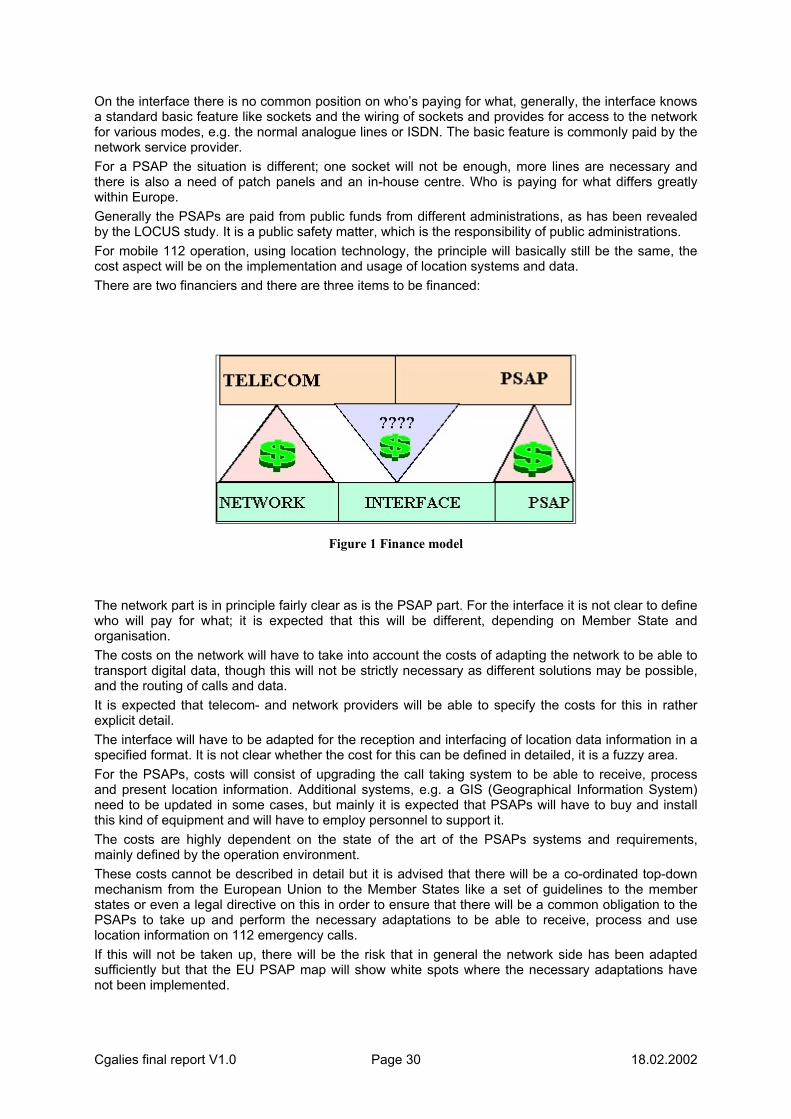
Cgalies final report V1.0 Page 30 18.02.2002
On the interface there is no common position on who’s paying for what, generally, the interface knows a standard basic feature like sockets and the wiring of sockets and provides for access to the network for various modes, e.g. the normal analogue lines or ISDN. The basic feature is commonly paid by the network service provider. For a PSAP the situation is different; one socket will not be enough, more lines are necessary and there is also a need of patch panels and an in-house centre. Who is paying for what differs greatly within Europe. Generally the PSAPs are paid from public funds from different administrations, as has been revealed by the LOCUS study. It is a public safety matter, which is the responsibility of public administrations. For mobile 112 operation, using location technology, the principle will basically still be the same, the cost aspect will be on the implementation and usage of location systems and data. There are two financiers and there are three items to be financed:
Figure 1 Finance model
The network part is in principle fairly clear as is the PSAP part. For the interface it is not clear to define who will pay for what; it is expected that this will be different, depending on Member State and organisation. The costs on the network will have to take into account the costs of adapting the network to be able to transport digital data, though this will not be strictly necessary as different solutions may be possible, and the routing of calls and data. It is expected that telecom- and network providers will be able to specify the costs for this in rather explicit detail. The interface will have to be adapted for the reception and interfacing of location data information in a specified format. It is not clear whether the cost for this can be defined in detailed, it is a fuzzy area. For the PSAPs, costs will consist of upgrading the call taking system to be able to receive, process and present location information. Additional systems, e.g. a GIS (Geographical Information System) need to be updated in some cases, but mainly it is expected that PSAPs will have to buy and install this kind of equipment and will have to employ personnel to support it. The costs are highly dependent on the state of the art of the PSAPs systems and requirements, mainly defined by the operation environment. These costs cannot be described in detail but it is advised that there will be a co-ordinated top-down mechanism from the European Union to the Member States like a set of guidelines to the member states or even a legal directive on this in order to ensure that there will be a common obligation to the PSAPs to take up and perform the necessary adaptations to be able to receive, process and use location information on 112 emergency calls. If this will not be taken up, there will be the risk that in general the network side has been adapted sufficiently but that the EU PSAP map will show white spots where the necessary adaptations have not been implemented.

Cgalies final report V1.0 Page 31 18.02.2002
6.4 Cost assessment of mobile network implementation This information is based on a synthesis of the reaction by mobile operators. It should be mentioned however that there is considerable uncertainty and divergence in operator plans. Operators replied on the basis of the best available information but indicated that plans may change depending on commercial drivers and any common solutions for emergency communications that may be agreed and mandated at a national level.
Synthesis of reactions Commercial location services are currently entering the marketplace. Few commercial implementations are deployed today, all based on Cell ID. A much greater range of commercial services may be expected to become available later this year, again based on Cell ID. Several operators indicated that they will enhance their location capability with Timing Advance (TA) within the next 6 – 24 months. Other operators indicate that they will launch Cell ID with NMR within that same timeframe. Again others will not consider a TA or NMR implementation. The technical solution for passing Cell ID value and Calling Line Identification to the PSAP is often different from the commercial implementation and often requires manual intervention. The provision of this type of information is sometimes subject to agreements with the emergency services or they must be provided under an obligation from the national government. Where location based services are deployed, the incremental cost for upgrading systems for the automatic provision of Cell ID, TA and NMR to the PSAP was estimated between 0-10 M Euros. Coverage of Cell ID can be up to 100 % right from the beginning. All operators plan to upgrade their networks for the provision of high accuracy location services, but strong divergence is evident in their plans. About one third of the operators that responded believe that implementation of E-OTD technology would be too expensive for them to justify the expenditure (in the order of tens of Million of Euros). These operators opt for an Assisted-GPS solution only. The cost for implementing the A-GPS solution was said to be below 10 M Euros whilst the cost of individual terminals would increase by up to 150 Euros in the short term and 50 Euros in the long term (depending on platform and software rights, estimates showed strong variation). Implementation of A-GPS will start within the next 2 years but for some operators this may be later (2-4 years). A-GPS may be expected to reach between 25 % and 75 % penetration by the end of 2006 but there were dissenting views by those operators who estimated higher cost of terminals (13 %). Some other operators said they have plans for the introduction of E-OTD over the next 2-4 years. Estimated network cost was said to vary from 10 – 100 M Euros, depending on the size of the country and the number of base stations in a network that would need to be equipped with timing reference stations (3200 Euros per BTS). The increment of terminal cost would be small (from less than 1 Euro up to 25 Euro). Penetration estimates largely vary. Some believe that they could reach a level of 75 – 100 % by the end of 2006 whilst others are more cautious estimating that the penetration rate of new terminals will follow a natural rhythm to range between 5 and 10 % per year. General agreement exists that E-OTD will only be deployed in areas where commercial applications are of value, i.e. in urban areas. Operators were remarkably consistent in their assessment that only 50 % of their GSM network would reasonably be covered by E-OTD. Some Operators felt that investments and costs must be carried by operators and PSAPs, depending on their respective functional and technical responsibilities. Operator responsibility would stop at the point of physical interconnect. Most operators felt that the cost for implementation of the interface with the location services platform would be borne by the operator, whilst the PSAP would bear the cost of its equipment, data bases including the cost of any functionality upgrades. Some operators however expressed a believe that, as emergency calls fall within the public service area, they should be financed by public funds or investment cost and service cost will be charged to PSAPs at rates that are valid for third parties. Some Operators also linked any upgrade of their systems and interface to a reciprocal action by the PSAP.

Cgalies final report V1.0 Page 32 18.02.2002
6.5 Who pays the bill True Enhanced 1-1-2 does not exist today in any of the EU member countries. Enhanced emergency telecommunications is defined as Caller Number Identification (CANI), Caller Location Identification (CALI) and correct routing of all emergency calls to the proper PSAP and emergency services for a given caller (fixed or mobile) location. This is an enhanced service for telephones, such as “call forwarding” or “calling party number display”, for which additional charges are assessed by Operators. To pay for true Enhanced 1-1-2 and all of its inherent benefits, each subscriber should pay 1 to 2 Euros a month. This is the cost model that is widely deployed in the USA for 911 operation. If this is implemented (by public vote and legislation), all costs to implement and maintain Enhanced 112 systems could be covered. This finance mechanism would allow governments to employ more emergency personnel, vehicles and other needed equipment. In this way all EU citizens would benefit of an enhanced 112 service. A number of different scenario's can be considered: • Scenario 1; Telecom operators are to pay for the development and implementation and cover all
related costs. PSAPs gets the service for free. This means that telecom operators develop a standard service to deliver to PSAPs, and the service could not be fitted according to PSAPs wishes.
• Scenario 2; Telecom operators and PSAPs are to split the costs for development and implementation 50/50.
• Scenario 3; Telecom operators are to pay for the development and implementation. PSAPs buy the services from telecom operator to cost. This means that telecom operators do not make money out of this service but will cover their expenses for development and implementation. The service may be fitted according to the PSAPs wishes for an additional fee.
• Scenario 4; Telecom operators develop and implement the service on commercial terms according to a business plan. PSAPs pay the amount the telecom operator requests on commercial terms. This also means that telecom operator has a right to not develop and offer the service if the customer base is to small or strategic measures says otherwise. This also means that some operators may choose other solutions than discussed in CGALIES based upon competitive or economic factors.
• Scenario 5; Telecom operators cover the expenses for development and implementation in their network. PSAPs cover the expenses for development of and implementation on their side. In between the telecom operator and the PSAPs is an interface that needs to be defined. Telecom operators and PSAPs should agree upon this interface and split the costs for implementation 50/50. This scenario could be done in combination with scenario 2, 3 and 4 above.
• Scenario 6; The last scenario is that the government of each country funds development and implementation of location information. This also means that there could be different guidelines in each country how location information should be provided and presented. This will ensure the same service and standard from all telecom operators in a country, and will make it easier for PSAPs to find necessary equipment on their side.
Cgalies final report V1.0 Page 33 18.02.2002
7 MATCHING SOLUTIONS.
7.1 Implementation scenarios. The implementation of Enhanced Emergency call Systems includes a number of aspects which could be potentially regulated e.g. the provision of location information, its Quality of Service (QoS), roaming aspects, financing etc. This chapter will focus on the description of two rather broad scenarios:
1. Scenario A with regulation in the sense that location information has to be passed to PSAPs. 2. Scenario B with regulation in terms of defined requirements for the quality of localisation
information, dates for mandatory implementation and a general principle for financing.
These scenarios provide the boundaries of the different approaches that can be followed. They are indicative and are provided here for the sake of discussion and consensus building. The first scenario is a pure market scenario while the second option is a regulatory top down approach concerning aspects as minimum accuracy and timelines. For these two scenarios the related relevant technical options, the implementation costs and their apportionment and tentative implementation plans (in terms of schedule, financing and organisational aspects will be studied. The final recommendation has to be positioned somewhere between those two markers and there will be elements from both markers to a greater or lesser extent, depending on the position of the final recommendations.
Scenario A: Market Driven The Scenario A “Market driven” represents a moderate option for the implementation of E-112 in Europe in terms of regulatory impact. In fact the regulatory impact neither will have to be extended beyond the existing framework nor the current regulatory proposal. The current legal situation for location data at the moment is:
• location data is not explicitly mentioned in Directive 97/66 • localisation data aspects are partly covered by the provisions on traffic data and more
generally by the EC General Data Protection Directive 95/46. • the general data protection rules allow an override of the consent requirement where this is
necessary to protect “the vital interests of the individual” (art.7 d) of 95/46.
The current regulatory-proposal places obligations on the Member States, including that: • Caller location information must be made available to PSAPs where "technically feasible" for
112 calls. • Calls made to the European emergency number 112 are free of charge. • the processing of location data will only be allowed with the consent of subscriber. • the subscriber must be able to block the processing of location data on a temporary basis,
with the exception for 112 calls. • an override of privacy has to be made available for emergency services.
The telecom providers, who have implemented localisation technology in any form, will be obliged to pass this information to the PSAPs, but no specified requirements regarding accuracy, integrity, availability, latency, etc. will be defined and the telecom provider could pass on the location information to the PSAP in that level of quality, which corresponds to the available technology and network characteristics. It is assumed here that this refers to the automatic transfer of location data between Telecom provider and PSAPs.
Cgalies final report V1.0 Page 34 18.02.2002
As such the interface between the Telecom provider and the PSAPs must still be defined and it is assumed this interface will make available to the PSAPs the position of the caller and an estimation of accuracy. There will be additional costs to the Telecom provider and the PSAPs to provide and use this interface. Regarding organisational aspects It is assumed that the obligations of the Member states as per the proposed regulation for the access to the location information will be carried out under the responsibilities of the national emergency authority on the national administration level. The current regulatory proposal does not specify whether or not the PSAPs must be able to exploit the digital information automatically provided. It is advised that PSAPs will have to provide for the necessary equipment to be able to receive and handle location data. There are similarly no a priori explicit requirements for implementation deadlines in this scenario, even if the term ‘where technically feasible’ will need to be interpreted. Regarding the time scale it is assumed that the obligations of the proposed regulatory framework will enter into force by January 2003.
Scenario B: Regulated . Scenario B represents the option with a strong regulatory mandate. It will be defined by three conditions:
1. The network providers will have to provide access to the location information without taking into account the capabilities of the responsible PSAPs to handle the location data in an appropriate manner.
2. The national 112 authority of each Member State shall be obliged to provide for the necessary budgets to equip all PSAPs with location data handling equipment within a set timeframe (2003 possibly).
3. The PSAPs on each level are obliged to provide for the necessary equipment to be able to receive and handle location data in a suitable manner within a set timeframe (2003).
The full benefit for the citizens can only be achieved if the whole “rescue-chain” is fully operational concerning location data, it is strongly recommended that all three conditions are complied with. Appropriate financing models for cost sharing between the involved parties will have to be agreed. First of all, the performance requirements, proposed for scenario B refer to the quality of the location information. They have been derived from the questionnaire elaborated in co-operation of LOCUS and CGALIES and the feasibility-check performed in WP 2000 of LOCUS (see D2). The localisation of the person in distress has the most stringent requirements. This represents the core of E-112 and should be fulfilled as a first priority. This could be reached from a technical point of view within a timeframe till approximately 2007 either by hybrid solutions in all environments or by single solutions in some of the identified environments. Basic systems are estimated to be available approximately in 2003.

Cgalies final report V1.0 Page 35 18.02.2002
The recommendations for scenario B are: Scenario B requirements Phase1 Phase2 Horizontal Accuracy 500m6 100m 7
Vertical Accuracy not regulated8 not regulated ?? Reliability >67%9 >67%10 Coverage Network coverage not defined 11 Availability 99.95% within network
coverage not defined 12
Latency 5s 30s Standardisation 13 Yes Yes Interoperability no14 No
6 The performance of the technologies, which are available within the time-frame of phase 1, correspond fully to the user requirements for “call routing” and “dispatching of rescue team” and to some extend also for “caller localisation” (see scenario A). BUT: Requirements and performance of technology are strongly depending on the environment (urban, rural, etc.) which implies that for a regulation by minimum accuracy levels by figures (e.g. 500m in urban environment, 5km in rural environment, etc.) a legal valid definition of the environments will be needed. This is not available and in practice it will not be possible to define the frontiers between these environments and structure the European territory into urban-, rural-regions, etc. on a large scale. 7 the 100m requirement is derived from the results of the feasibility check between user requirements for “caller localisation” and performance of future technologies described by D2 of LOCUS 8 Accordingly the current state-of-the-art no technology will be available to fit user requirements for indoor and underground within the considered time-frame ?? 9 Based on available information derived from tests (see D2 of LOCUS) 10 Minimum reliability, which should be increased corresponding to results of further investigations of potential performance of various technologies. Appropriate testing-mechanisms must be developed 11 because the definition of coverage indicates an indirect selection of technology (rural = A-GPS, urban/indoor = E-OTD/OTDOA) 12 information on the availability of enhanced technologies within defined environments is not available at the moment 13 To ensure roaming for “foreign callers” and vice versa operability in other member states (if a network with the same technology is available) 14 because this requires an agreement of all European service providers to install the same technology (interoperability between networks equipped with the same technology should be ensured by standardisation, see above)
Cgalies final report V1.0 Page 36 18.02.2002
7.2 Migrations issues Based on the current developments in the area of location based VAS (defined as type 3 services within the LOCUS-study) it can be estimated that a remarkable number of European telecommunication providers will implement LBS until 2003. Current market surveys estimate world-wide 565 million active users of these services in 200615. The majority of current provided LBS are based on cell ID by proprietary solutions. Enhanced technologies like E-OTD, A-GPS are not deployed today. The situation for future generations of mobile communication is as follows:
• 2,5G • similar technology to GSM • standards expected in early 2002 • first products and services mid 2003 • 3G • standards expected in Q3 2001 (cell ID+RTT, A-GPS, OTDOA, OTDOA-IPDL) • first products and services mid 200316
Due to the fact that the majority of LBS can be exploited by using cell ID it is not expected that network providers will implement enhanced technologies to a large extent. The increasing number of mobile emergency calls will require appropriate methods to pass the location information to the PSAPs. In case the PSAPs will be equipped with GIS the position can be introduced either manually or automated for further operations. Scenario A will be connected with additional cost for implementation and maintenance, which could either be paid by the network providers (for the reasons mentioned above) or by public sources. A cost sharing between both parties involved has to be considered, too. The level of accuracy provided by the technology, which is expected to be implemented by the network providers will be:
• cell ID only: the advantages will be reduced to environments equipped with small-size cells (urban: 100m, 10m for Pico cells)
• cell ID+TA: the user can be located within a circle segment of 550m width. A combination of this information with GIS information (e.g. road network) can further reduce the position in some cases (e.g. car accidents)
• cell ID-CGI: localisation of caller within an accuracy level of 2,5-4 km (urban-rural) This demonstrates that the benefit derived from scenario A is strongly depending on the choice of technology, which is (due to the fact that scenario A is not defined by performance requirements) left to the network providers and therefore strongly depending on their assessment of a business case for LBS requiring a higher accuracy than “cell ID-only” will provide. Additional implementation costs will be reduced to a minimum amount beside what is already planned from the network providers. The provision of location information in case of emergency can also be considered as an important market differentiator between service providers, because safety is one of the key-aspects for citizens to by a mobile phone. The safety of the citizens will be increased by:
• reduced rescue time by improved dispatching of rescue teams (depending on environment and used technology)
• improved caller localisation (depending on used technology and useful combination with GIS)
15 LOCUS report D1 “Overview of Location Services” 16 CGALIES – WP1 report
Cgalies final report V1.0 Page 37 18.02.2002
8. CONCLUSIONS. When implementing the proposed directive on an obligation for networks to make caller location information available, member states should avoid too much regulation. An obligation for operators to deliver the best location information that is available within the network will in most cases deliver appreciable benefits for callers using both fixed and mobile networks. Some networks will be able to deliver location information within some months, and most networks within a year or two. Based upon information provided by network operators, it is assumed that all mobile operators will implement commercial location based services. The accuracy of the location information for mobile networks will gradually improve with the development of technology and with the penetration of location-enabled mobile handsets. Major differences exist throughout the EC in the way networks process 112 calls, in how the PSAPs are organised and how these PSAPs handle the calls - there is often a stage 1 and stage 2 PSAP. Currently, 112 calls are not always routed to the correct PSAP and there is variable assurance that 112 calls always reach a PSAP. Some databases for fixed line addresses already exist, but have appreciable limitations in both accuracy and scope of data provided, as well as accessibility for PSAPs. For improved 112 service, a number of fundamental improvements are required. Location information from 112 databases for fixed networks and sources of dynamic terminal location information for mobile networks needs to be rapidly accessible to PSAPs. These location sources need to be kept accurate and aligned with common digital maps in use in the geo-political area in which the 112 service is provided. At least daily updates are needed for fixed line databases, and addresses for all numbers, including non-published ones, must be included in accordance with Data Protection Directives. Networks and PSAPs should ensure there are no single points of failure throughout their networks and systems, as well as from the caller's serving switch to the responding PSAP. Networks need to support accurate, automatic routing of 112 calls to the correct PSAP that covers a caller's area, and the PSAPs should be able to automatically display to 112 call-takers the Calling Line Identification (CLI), caller's location and the telephone numbers of other PSAPs and emergency service agencies that cover the caller's area. The aim should be to develop common standardised data formats and common standardised interfaces for the transfer of location information . If possible, the data format and interface should allow the PSAP to easily use the information with readily available equipment during any initial implementation phase. Proprietary technical solutions are more expensive than "off-the-shelf" equipment and should generally be avoided. If a "de facto" standard is developed there will most likely develop a mass market for hardware and software, thereby reducing the cost for implementation and allowing for quicker future extensions of the standards to include information from services such as Automatic Collision Notification systems . There should be no obligation for networks to deliver information, until a PSAP can receive and utilise the information. In a lightly regulated, market driven scenario, the basic principle for financing is that the network should be responsible for the financing of network investments, the PSAP should be responsible for the financing of PSAP investments and training. Network investments caused by PSAP requirements going further than commercial requirements should be financed by the PSAP. The delivery of location information from the network to the PSAP should be free of charge for the subscriber at point of use, in accordance with European regulation. The main obstacle for implementing location information with emergency calls will most likely be, that the strained public budgets will have problems including an investment in equipment for utilising location information at PSAPs. Hence, responsible authorities in the member states must be notified about the importance of this issue, and the future public benefits that will be derived if the financing issues are solved. The production of this paper, in the context of CGALIES, has greatly facilitated the public debate on issues regarding the implementation of enhanced 112 (E112) in Europe. This work and its findings, together with other work done in the same field, will now be carried forward into the study that Helios Technology is doing for the Commission. This latter study should result in draft recommendations for the implementation of E112 in Europe, for consideration by a future meeting of CGALIES.

Cgalies final report V1.0 Page 38 18.02.2002
9 GLOSSARY OF TERMS: ACPO: Association of Chief Police Officers. ACPOS: Association of Chief Police Officers Scotland. A-GPS Assisted GPS AIR Automatic Incident Reporting ALI Automatic Line Identification ANI Automatic Number Identification AVL Automatic Vehicle Location BT British Telecommunications PLC BTS Base Transceiver Station CALI Caller location Identification. CANI Caller Number Identification. CAS Call Associated Signalling CGALIES Co-ordination Group on Access to Location Information by Emergency Services CHA: Call Handling Agent. CID Company Identifier CLI Calling Line Identity CWC Cable and Wireless Communications DDI Direct Dial In DG ENV EU Directorate Environment DG INFSO EU Directorate General Information Society DOT Department of Transport EA: Emergency Authority. EACR Emergency Authority Control Room E-CGI Enhanced Cell Global Identity EDSP Emergency Data Service Provider. EENA European Emergency Numbering Association. EISEC: Enhanced Information Service for Emergency Calls. EMS Emergency Medical Service E-OTD Enhanced Observed Time Difference ESN Emergency Service Number ESZ Emergency Service Zone FCC Federal Communication Commission FHWA Federal Highways Agency GDF Geographic Data File GIS Graphic Information System GMLC Gateway Mobile Location Centre GPRS General Packet Radio Service GPS Global Positioning System GSM Global System for Mobile Telecommunication IPDL Idle Period Downlink ISDN Integrated Services Digital Network LBS Location Based Services LIF Location Interoperability Forum LNP Local Number Portability

Cgalies final report V1.0 Page 39 18.02.2002
LOCUS Location of Cellular Users for Emergency services LR Location Reference MSAG Master Street Address Guide MSC: Mobile Switching Centre. NENA National Emergency Number Association. NMR Network Measurement Report OC Operator Centre [Fixed Network] OTDOA Observed Time Difference Of Arrival PABX Private Automatic Branch Exchanges PALI Pseudo Automatic Location Identification PANI Pseudo Automatic Number Identification PECS: Public Emergency Call Service. PNO: Public Network Operator. PSAP Public Service Answering Point PSTN: Public Switched Telephone network QoS Quality of Service RTT Round Trip Time SR Selective Routing ST Selective transfer TA Timing Advance UMTS Universal Mobile Telecommunication System VAS Value Added Service. VDU Visual Display Unit XD: Ex-Directory (phone number)

Cgalies final report V1.0 Page 40 18.02.2002
10 LITERATURE 1 Automatisches Notrufsysteem, positionspaper des Zentralverbandes Elektrotechnik- und
Elektronikindustrie e.V und des Verbandes der Automobilindustrie e.V in zusammenarbeit mit dem Deutschen Verkehrsicherheitsrat e.V.
2 Final report of workpackage 1 CGALIES on Minimum ‘standards’ on location data accuracy, reliability and evolution path. Minimum requirements for location reference system.
3 IST-1999-14093 LOCUS, Deliverable 1, Overview of Location Services. 4 Deliverable 2, Service definition for Enhanced 112 emergency services, dated 14 September
2001, LOCUS. 5 Deliverable 3, Implementation options for enhanced 112 emergency services, dated 20
September 2001, LOCUS. 6 Deliverable 4, Recommendations, dated 6 November 2001. 7 Questionnaire on the requirements of National Civil Protection Authorities regarding the location of
callers in emergency situations (Enhanced 112)" 8 Proceedings of a workshop, organized by the Civil Protection Authority in Luxembourg.
Cgalies final report V1.0 Page 41 18.02.2002
11 ANNEXES. The following annexes are added to this document:
1 Final report of CGALIES Work Package 1 on Minimum ‘standards’ on location data accuracy, reliability and evolution path. Minimum requirements for location reference system.
2 Questionnaire on the requirements of National Civil Protection Authorities regarding the location of callers in emergency situations (Enhanced 112).
3 List of CGALIES members.
Cgalies final report V1.0 Page 42 18.02.2002
11.1 ANNEX 1, WP 1 report.
Co-ordination Group on Access to Location
Information by Emergency Services
Work Package 1
: Authors: Brendan Ludden (chairman WP 1).
Andrew Pickford Jean Pierre Vincent Pekka Heikkinen Gemma Paris Peter Salmon Roger Paul Tim Dunn Rob Davies Sian Evans Jan Malenstein (chairman Cgalies).
Cgalies, Final report V1.0 43 18.02.2002
REVISION
Issue:
Reason for up-issue: Date of Issue:
1 First Draft 11th April 2001 2 Second Draft 19th April 2001 3 Third Draft 8th May 2001
DISTRIBUTION
CGALIES PLENARY
Cgalies, Final report V1.0 44 18.02.2002
Introduction In its review of the telecommunications regulatory framework, the Commission proposed in July 2000 that telecommunications operators make caller location information available to emergency authorities, where technically feasible, for all 112 calls. The terms of the requirements, which would apply to both fixed and mobile telephony, are discussed by the European Council and the European Parliament and need to be approved by the end of 2001. To complement and facilitate the political discussions, the Commission set up a Co-ordination Group on Access to Location Information by Emergency Services: CGALIES (more information is available at: www.telematica.de/cgalies). The group includes representatives of the telecommunications industry (manufacturers and operators) and emergency service authorities. The main task of CGALIES is to identify the relevant implementation issues with regard to enhancing emergency services in Europe with the provision of location information in a timely and financially sound manner, to analyse and describe them and to build a consensus on the Europe-wide implementation.
Scope The establishment of CGALIES by the Commission gives recognition to the fact that that emergency communications necessitate the passing of information across both private and public sector boundaries and that each sector will need to work to support the other. Accordingly, for a successful implementation of enhanced 112 emergency services to be achieved, a large number of issues need to be clarified including the co-ordination of the time scales for the implementation of new systems. This requires a consensus between all players about the implementation details in order to achieve a co-ordinated introduction and to ensure that investments in new systems are safeguarded. To achieve this three work packages have been defined within CGALIES. This document is a summary of the work carried out in Work Package 1. The scope of Work Package 1 was defined as follows: • The identification of minimum standards on location accuracy and reliability • Timetable for the introduction of the above agreed standards • Minimum requirements for the location reference system.
Process The inaugural meeting of Work Package 1 (WP1) was in September and WP1 ran for 4 meetings including 3 workshops. Attendance varied between 20-40 attendees and comprised of a cross section of representatives from mobile network operators, equipment manufacturers, location technology providers, emergency service personnel and regulators. The approach throughout Work Package 1 was to build consensus on what the requirements of the emergency services are, to build consensus on the performance of different location technologies and also to build consensus on what the mobile network operators can realistically deliver. • During the CGALIES plenary session in June the scope of Work Package 1 was drafted. • During the first Work Package 1 meeting a strategy on how to fulfil the scope set by the plenary
was formulated. A set of minimum requirements was defined in this meeting. To establish what the minimum requirements should be, a set of parameters were identified
• Workshops 1-3 were used to define the parameters associated with the minimum set of requirements. The approach was to assess the requirements of the emergency services first, then assess what the technology could deliver and find the common ground. This process is then further moderated by the cost implications on the PSAPs and the network operators from WP3.
The final deliverable from WP1 is this document which summarises the knowledge and expertise generated through the WP1 process.

Cgalies, Final report V1.0 45 18.02.2002
Executive Summary Cell ID location technology should be achievable within 2 years in all European Union based network operators. This technology does not require new handsets so will be available to all citizens in all networks in all member states. Thus in this time frame, it is will be possible to route emergency calls based upon Cell ID accuracy. Additionally, with development of existing network architecture to a standardised 'Location Services Architecture' it will be possible to provide Cell ID based location information to the emergency services across a standardised interface. More accurate location technologies will have a significantly longer lead-time. The increase in time is partly due to the high cost and thus the requirement that an appropriate business model is in place for the industry to support them. The need for a strong business case is especially relevant in light of the 3G licence costs and the present economic climate in the telecomm sector. The availability and penetration time of new infrastructure and new handsets is also a significant factor widespread availability, especially the time it takes for new handsets to penetrate the existing subscriber base. However, the equipment in PSAPs are unlikely to be upgraded for location services across the whole of the EU until ~2007 anyway (if a decision to regulate E112 is made in 2002). Therefore the time-scales of when accurate location technology is available and cost effective and when it is feasible to have all PSAPs in the EU with the ability to use location information, appear to match well. Given the above information there appears to be little need to regulate for anything other than Cell ID location technology in the medium term – if at all. Cell ID is sufficient for routing a call to the correct PSAP and in many cases it will be sufficient in identifying call clusters. However, Cell ID will not be sufficient for the high accuracy requirements associated with the operational response of emergency service units to unknown user locations. But, by the time PSAPs are able to upgrade their equipment to utilise location information EU-wide, it is probable that high accuracy location technology will be widely available in many, if not all, European Networks. It is recommended that the effort in the Commission should be directed at helping the European PSAPs harmonise deployment of the required equipment for emergency location support. It is also recommended that the PSAP community receives sufficient information on how location technology can be used effectively as a tool for all accuracy levels.
Minimum Requirements As mentioned above a set of minimum requirements were defined, which needed to be fulfilled in order to provide emergency location services
A Europe-wide standardised interface between PSAP and network The exchange of position estimate and other information between the Network Operator and the PSAP should take place across a standardised interface. This interface is called the Le interface and sits between any application external to the network (emergency services is one example) and the Gateway Mobile Location Centre (GMLC). This interface will be standardised and a large portion of that work may be carried out in the Location Interoperability Forum.

Cgalies, Final report V1.0 46 18.02.2002
Accuracy requirements
Minimum level of accuracy There should be a realistic minimum requirement on accuracy. An early requirement at this stage will drive the implementation of architectural changes in the network that is essential to collect and deliver location information for all standardised location technologies. The only realistic early minimum requirement is to use cell ID accuracy. Cell ID is unique in that this information is available for all handsets in all networks now, although development work is required in each network to extract the Cell ID and convert it to a meaningful location estimate. The cell ID method provides the position of the base site as the position estimate of the mobile connected to that site. The size of cells ranges from 10m to 30km. Pico cells are indoor cells with a cell size comparable to room sizes. Micro cells are deployed in busy town centres or similar high call density areas and are typically 100-200m in size. Macro cells range in size from suburban cells, which are typically several kilometres to rural cells, which are typically, tens of kilometres. Improvements in Cell ID accuracy can be achieved by enhancing them with network measurement reports, measured power levels at the handset from neighbour sites and Timing Advance. There are many complicated factors that affect accuracy in all location technologies and it is difficult to ascertain which effects will be dominant in emergency situations. The whole issue of minimum accuracy requirements should be approached with caution as is illustrated by the problems encountered by the FCC in US.
Improvement in Quality of Service over time This will occur, as more location-enabled handsets enter the marketplace. However, the discussion in this area will probably be to decide whether market forces are sufficient or whether detailed regulation is justifiable to try to speed up the process.
Accuracy for Emergency calls shall be as good as for commercial applications The spirit of this comment is to ensure that the best location technology available in the network is used for emergency services – not reserved in someway for commercial services only. For standardised location methods this will be the case anyway as the network interfaces with commercial applications and with PSAPs the same way. In fact it is likely that the best location possible will be provided for emergency services, whereas restricted location information will be available to many commercial applications. It is recommended that only standardised location methods be adopted.
Accuracy Estimate There shall be an estimate of how accurate the reported position is, in order for the emergency services to make appropriate use of the information. A format for this information in the form of an uncertainty ellipse has already been defined in the standards and should be reviewed to ascertain that it is suitable for the emergency services.
The technology used should be compliant with available standards Only standardised solutions should be considered. We want to have a Europe wide solution and ensure that any PSAP can interface with any operator and receive the requested information in an agreed format.
Cgalies, Final report V1.0 47 18.02.2002
Regardless of the outcome of the CGALIES process, a review of the state of emergency location services should happen after 18-24 months All recommendations made here will need to be reviewed with time, as will the compliance of the various parties to any such recommendations. It is important to outline a review process to ensure that the work and ideas captured during these meetings is kept up to date as technology and the market develops.
The location estimate should be able to facilitate call routing to the ‘geographically’ appropriate PSAP It is important to ensure that all calls are routed to the correct emergency service (geographically) to optimise speed of response.
Parameters for fulfilling minimum requirements
Introduction The performance of various technologies varies according to a number of different parameters, including accuracy, reliability/yield, penetration, time to fix/latency, coverage/availability, timescales, useability, roaming/interoperability and location reference system. For each dimension the technology requirements and capability is discussed in this section.
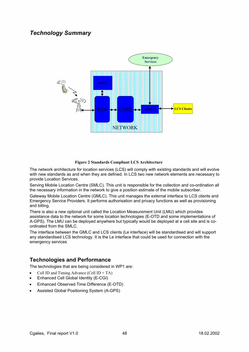
Cgalies, Final report V1.0 48 18.02.2002
Technology Summary
����������������������������������������������������������������������������������������������������������������������������������������������������������������������������������������������������������������������������������������������������������������������������������������������������������������������������������������������������������������������������������������������������������������������������������������������������������������������������������������������������������������������������������������������������������������������������������������������������������������������������������������������������������������������������������������������������������������������������������������������������������������������������������������������������������������������������������������������������������������������������������������������������������������������������������������������������������������������������������������������������������������������������������������������������������������������������������������������������������������������������������������������������������������������������������������������������������������������������������������������������������������������������������������������
LCS Clients
SMLC
GMLC
EmergencyServices
RAN
NETWORK
CORE
Figure 2 Standards Compliant LCS Architecture
The network architecture for location services (LCS) will comply with existing standards and will evolve with new standards as and when they are defined. In LCS two new network elements are necessary to provide Location Services. Serving Mobile Location Centre (SMLC). This unit is responsible for the collection and co-ordination all the necessary information in the network to give a position estimate of the mobile subscriber. Gateway Mobile Location Centre (GMLC). This unit manages the external interface to LCS clients and Emergency Service Providers. It performs authorisation and privacy functions as well as provisioning and billing. There is also a new optional unit called the Location Measurement Unit (LMU) which provides assistance data to the network for some location technologies (E-OTD and some implementations of A-GPS). The LMU can be deployed anywhere but typically would be deployed at a cell site and is co-ordinated from the SMLC. The interface between the GMLC and LCS clients (Le interface) will be standardised and will support any standardised LCS technology. It is the Le interface that could be used for connection with the emergency services
Technologies and Performance The technologies that are being considered in WP1 are: • Cell ID and Timing Advance (Cell ID + TA) • Enhanced Cell Global Identity (E-CGI) • Enhanced Observed Time Difference (E-OTD) • Assisted Global Positioning System (A-GPS)
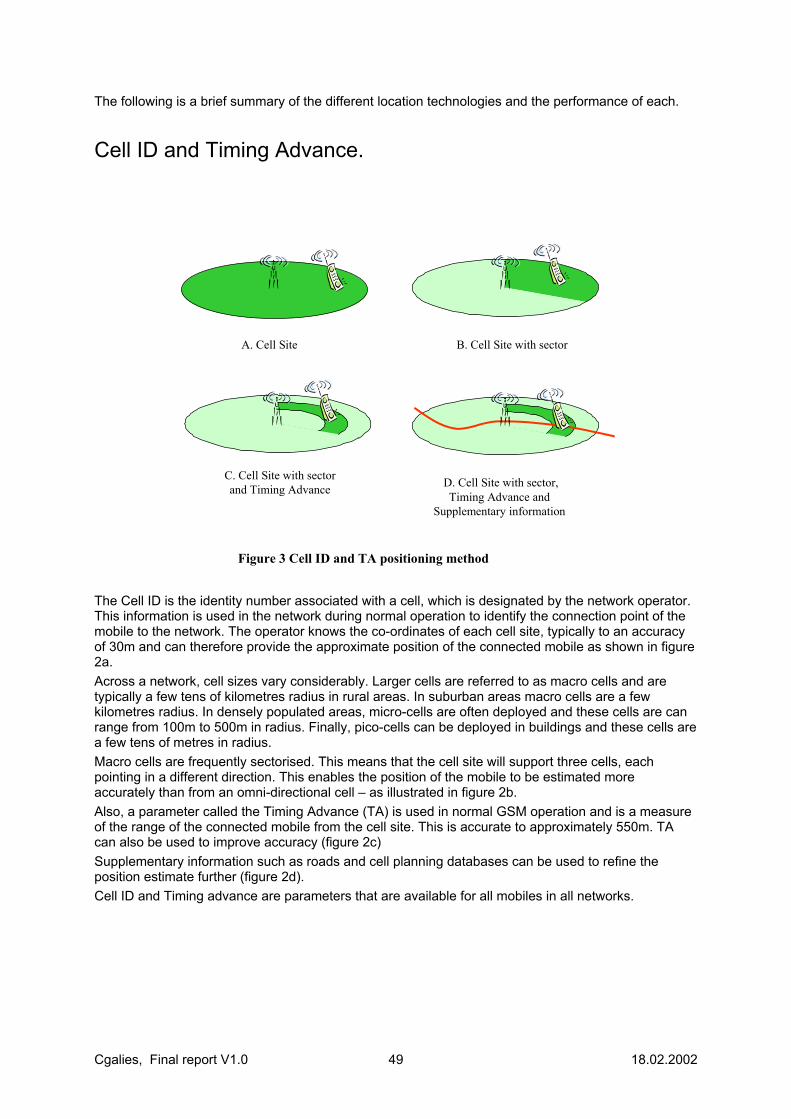
Cgalies, Final report V1.0 49 18.02.2002
The following is a brief summary of the different location technologies and the performance of each.
Cell ID and Timing Advance.
A. Cell Site B. Cell Site with sector
C. Cell Site with sectorand Timing Advance D. Cell Site with sector,
Timing Advance and Supplementary information
Figure 3 Cell ID and TA positioning method
The Cell ID is the identity number associated with a cell, which is designated by the network operator. This information is used in the network during normal operation to identify the connection point of the mobile to the network. The operator knows the co-ordinates of each cell site, typically to an accuracy of 30m and can therefore provide the approximate position of the connected mobile as shown in figure 2a. Across a network, cell sizes vary considerably. Larger cells are referred to as macro cells and are typically a few tens of kilometres radius in rural areas. In suburban areas macro cells are a few kilometres radius. In densely populated areas, micro-cells are often deployed and these cells are can range from 100m to 500m in radius. Finally, pico-cells can be deployed in buildings and these cells are a few tens of metres in radius. Macro cells are frequently sectorised. This means that the cell site will support three cells, each pointing in a different direction. This enables the position of the mobile to be estimated more accurately than from an omni-directional cell – as illustrated in figure 2b. Also, a parameter called the Timing Advance (TA) is used in normal GSM operation and is a measure of the range of the connected mobile from the cell site. This is accurate to approximately 550m. TA can also be used to improve accuracy (figure 2c) Supplementary information such as roads and cell planning databases can be used to refine the position estimate further (figure 2d). Cell ID and Timing advance are parameters that are available for all mobiles in all networks.
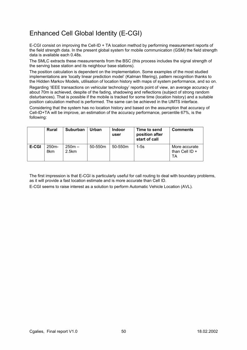
Cgalies, Final report V1.0 50 18.02.2002
Enhanced Cell Global Identity (E-CGI) E-CGI consist on improving the Cell-ID + TA location method by performing measurement reports of the field strength data. In the present global system for mobile communication (GSM) the field strength data is available each 0.48s. The SMLC extracts these measurements from the BSC (this process includes the signal strength of the serving base station and its neighbour base stations). The position calculation is dependent on the implementation. Some examples of the most studied implementations are ‘locally linear prediction model’ (Kalman filtering), pattern recognition thanks to the Hidden Markov Models, utilisation of location history with maps of system performance, and so on. Regarding ‘IEEE transactions on vehicular technology’ reports point of view, an average accuracy of about 70m is achieved, despite of the fading, shadowing and reflections (subject of strong random disturbances). That is possible if the mobile is tracked for some time (location history) and a suitable position calculation method is performed. The same can be achieved in the UMTS interface. Considering that the system has no location history and based on the assumption that accuracy of Cell-ID+TA will be improve, an estimation of the accuracy performance, percentile 67%, is the following: Rural Suburban Urban Indoor
user Time to send position after start of call
Comments
E-CGI 250m-8km
250m – 2.5km
50-550m 50-550m 1-5s More accurate than Cell ID + TA
The first impression is that E-CGI is particularly useful for call routing to deal with boundary problems, as it will provide a fast location estimate and is more accurate than Cell ID. E-CGI seems to raise interest as a solution to perform Automatic Vehicle Location (AVL).
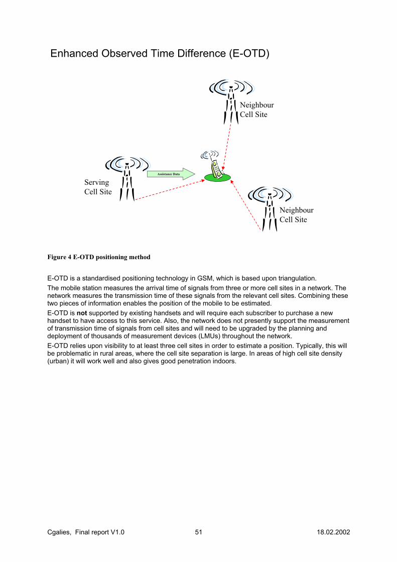
Cgalies, Final report V1.0 51 18.02.2002
Enhanced Observed Time Difference (E-OTD)
Assistance DataAssistance Data
ServingCell Site
Neighbour Cell Site
Neighbour Cell Site
Figure 4 E-OTD positioning method
E-OTD is a standardised positioning technology in GSM, which is based upon triangulation. The mobile station measures the arrival time of signals from three or more cell sites in a network. The network measures the transmission time of these signals from the relevant cell sites. Combining these two pieces of information enables the position of the mobile to be estimated. E-OTD is not supported by existing handsets and will require each subscriber to purchase a new handset to have access to this service. Also, the network does not presently support the measurement of transmission time of signals from cell sites and will need to be upgraded by the planning and deployment of thousands of measurement devices (LMUs) throughout the network. E-OTD relies upon visibility to at least three cell sites in order to estimate a position. Typically, this will be problematic in rural areas, where the cell site separation is large. In areas of high cell site density (urban) it will work well and also gives good penetration indoors.

Cgalies, Final report V1.0 52 18.02.2002
Assisted Global Positioning System (A-GPS)
����������������������������
��������������������������
��������������������� ������������� ��������������
���������������������
����������������������������
��������������������������
���������������������
Assistance DataAssistance Data
Cell Site
GPS Satellites
Position EstimatePosition Estimate
Figure 5 Assisted GPS positioning method
A-GPS is a standardised positioning technology in GSM and also in other radio access networks. A-GPS is not supported by existing handsets and will require the subscriber to purchase a new handset. Conventional GPS is a navigation system that utilises transmissions from a constellation of US government satellites. The system has been around since 1978 and is widely used in many non-military applications. However, the satellite signals were designed for outside operation and there remain problems with getting a position estimate indoors, or in situations where there is poor visibility of the sky. This is because the mobile requires visibility of at least 3 satellites for a 2 dimensional position estimate. To address this problem assistance data can be provided directly from the network operator to enable a GPS receiver to provide a position fix, even in challenging environments. The use of network assistance data to improve the performance of GPS is called A-GPS. There are different levels of assistance data that can be provided by the network. The better the assistance data, the better the service and performance of the technology – however, the higher the cost in the network. In some implementations of A-GPS LMUs will be required. In general the assistance method types can be termed as basic assistance and full assistance. ‘Full assistance’ brings improvements in sensitivity, time to first fix and accuracy over ‘basic assistance’. A general description of environments where A-GPS is typically demonstrated to work well is: outdoors, in car, in wooden buildings, in two storey buildings of brick/slate, and in steel/concrete buildings 1-3 metres from a window.
Cgalies, Final report V1.0 53 18.02.2002
Accuracy - Requirements
Caller Location There are three stages of an emergency call all of which have different requirements on location accuracy; initial call routing, routing for the purpose of dispatch and locating the caller. The accuracy requirements for each phase are described below; (a) Call Routing The accuracy requirements for routing an emergency call to the correct PSAP are approximately 1km-10km in urban and suburban areas, and 35km in rural areas. For most call routing needs, Cell ID is sufficient. More accurate technologies will provide only marginal improvements to the efficiency of this phase. (b) Dispatching of emergency request to relevant service and station The approximate accuracy requirements for dispatching an emergency call to the correct service and station (from the PSAP) based on the estimated location of the caller are typically 500m in urban areas, 5km in suburban areas, and 35km in rural areas. For most dispatching needs Cell ID is sufficient for many dispatching although more accurate technologies will provide some improvements. (c) Location of caller and/or incident Depending on the existence of a location estimate and location information provided directly by a caller we can identify three distinct means of locating the caller; The caller could simply provide location information verbally (although this would be regarded as unverified). The caller participates but a location estimate is available. In this case the desired accuracy of the location system is 25m-150m for calls originating from urban areas, 50m-500m for suburban areas, 100m-500m for the rural environment and 100m-500m for motorways or waterways. The caller is unable to provide location information but a location estimate is the only available source of caller’s location. In this case the desired accuracy needs to be improved to 10m-150m for urban areas, 10m-500m for suburban areas, 10m-500m for rural areas and 10m-500m for motorways or waterways. Verification of location information provided by a caller is, of course, desirable for all emergency calls. In this case the positioning accuracy for verification is identical to that required for the handling of call clusters. Furthermore, additional verification may be provided by delivering details of a user’s home address with the location estimate to the PSAP although practically this will be impossible to implement Europe-wide. Finally, the caller’s location needs to be referenced to a local map for emergency services to be delivered. In general 10m map accuracy is required – consistent with current map availability.
Other Call Types It is generally expected that vehicle-mounted positioning systems will provide a higher accuracy than handset-based positioning systems. If an emergency call originates from a vehicle-mounted positioning system then it is desirable that the emergency services are able to distinguish location estimated produced in this way. In addition, in some cases multiple location estimates from many callers may actually relate to the same incident. Distinguishing between ‘clusters’ that relate to the same incident and other calls requires positioning accuracies of 150m in urban areas, 500m in suburban areas, 500m in rural areas and 500m for calls from motorways or waterways. However, ‘good Samaritan’ calls reporting the same incident are included in the treatment of clusters. Finally, the perception that an emergency call will be located (to any level of accuracy) may, by itself, act as a deterrent to spurious or malicious calls. It is also expected that if such a caller was aware of the capability for increased accuracy this by itself would act as a more powerful deterrent to making these calls.
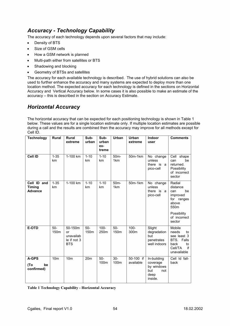
Cgalies, Final report V1.0 54 18.02.2002
Accuracy - Technology Capability The accuracy of each technology depends upon several factors that may include: • Density of BTS • Size of GSM cells • How a GSM network is planned • Multi-path either from satellites or BTS • Shadowing and blocking • Geometry of BTSs and satellites The accuracy for each available technology is described. The use of hybrid solutions can also be used to further enhance the accuracy and many systems are expected to deploy more than one location method. The expected accuracy for each technology is defined in the sections on Horizontal Accuracy and Vertical Accuracy below. In some cases it is also possible to make an estimate of the accuracy – this is described in the section on Accuracy Estimate.
Horizontal Accuracy The horizontal accuracy that can be expected for each positioning technology is shown in Table 1 below. These values are for a single location estimate only. If multiple location estimates are possible during a call and the results are combined then the accuracy may improve for all methods except for Cell ID. Technology Rural Rural
extreme Sub-urban
Sub-urban ex-treme
Urban Urban extreme
Indoor user
Comments
Cell ID 1-35 km
1-100 km 1-10 km
1-10 km
50m-1km
50m-1km No change unless there is a pico-cell
Cell shape can be returned. Possibility of incorrect sector
Cell ID and Timing Advance
1-35 km
1-100 km 1-10 km
1-10 km
50m-1km
50m-1km No change unless there is a pico-cell
Radial distance can be improved for ranges above 550m
Possibility of incorrect sector
E-OTD
50-150m
50-150m or unavailable if not 3 BTS
50-150m
100-250m
50-150m
100-300m
Slight degradation but penetrates well indoors
Mobile needs to see least 3 BTS. Falls back to Cell/TA if unavailable
A-GPS
(To be confirmed)
10m
10m 20m 50-100m
30-100m
50-100 if available
In-building coverage by windows but not deep inside.
Cell Id fall-back
Table 1 Technology Capability - Horizontal Accuracy

Cgalies, Final report V1.0 55 18.02.2002
Definitions Urban environment: Densely populated areas, multi-story buildings, offices, city centres.’ Suburban environment: Populated areas, residential houses. Villages.’ Rural environment: Sparsely inhabited areas, fields, forests.’ Figure 6 to Figure 8 illustrate a summary of the accuracy of the different location technologies mapped to the requirements of the emergency services. The blues boxes are the requirements for routing emergency calls. The red boxes are the requirements for finding emergency cases.
Accuracy (meters)1 3 10 30 100 300 1K 3K 10K 30K
Suburban
Indoor
Rural
Urban
DenseUrban
Figure 6 Emergency services requirements and Cell ID performance
Accuracy (meters)1 3 10 30 100 300 1K 3K 10K 30K
Suburban
Indoor
Rural
Urban
DenseUrban
Figure 7 Emergency services requirements and E-OTD performance
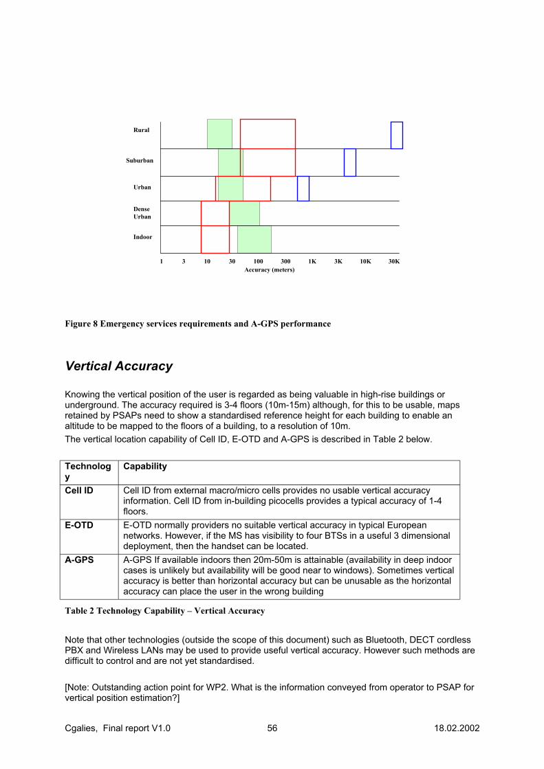
Cgalies, Final report V1.0 56 18.02.2002
Accuracy (meters)1 3 10 30 100 300 1K 3K 10K 30K
Suburban
Indoor
Rural
Urban
DenseUrban
Figure 8 Emergency services requirements and A-GPS performance
Vertical Accuracy Knowing the vertical position of the user is regarded as being valuable in high-rise buildings or underground. The accuracy required is 3-4 floors (10m-15m) although, for this to be usable, maps retained by PSAPs need to show a standardised reference height for each building to enable an altitude to be mapped to the floors of a building, to a resolution of 10m. The vertical location capability of Cell ID, E-OTD and A-GPS is described in Table 2 below. Technology
Capability
Cell ID Cell ID from external macro/micro cells provides no usable vertical accuracy information. Cell ID from in-building picocells provides a typical accuracy of 1-4 floors.
E-OTD
E-OTD normally providers no suitable vertical accuracy in typical European networks. However, if the MS has visibility to four BTSs in a useful 3 dimensional deployment, then the handset can be located.
A-GPS
A-GPS If available indoors then 20m-50m is attainable (availability in deep indoor cases is unlikely but availability will be good near to windows). Sometimes vertical accuracy is better than horizontal accuracy but can be unusable as the horizontal accuracy can place the user in the wrong building
Table 2 Technology Capability – Vertical Accuracy
Note that other technologies (outside the scope of this document) such as Bluetooth, DECT cordless PBX and Wireless LANs may be used to provide useful vertical accuracy. However such methods are difficult to control and are not yet standardised. [Note: Outstanding action point for WP2. What is the information conveyed from operator to PSAP for vertical position estimation?]
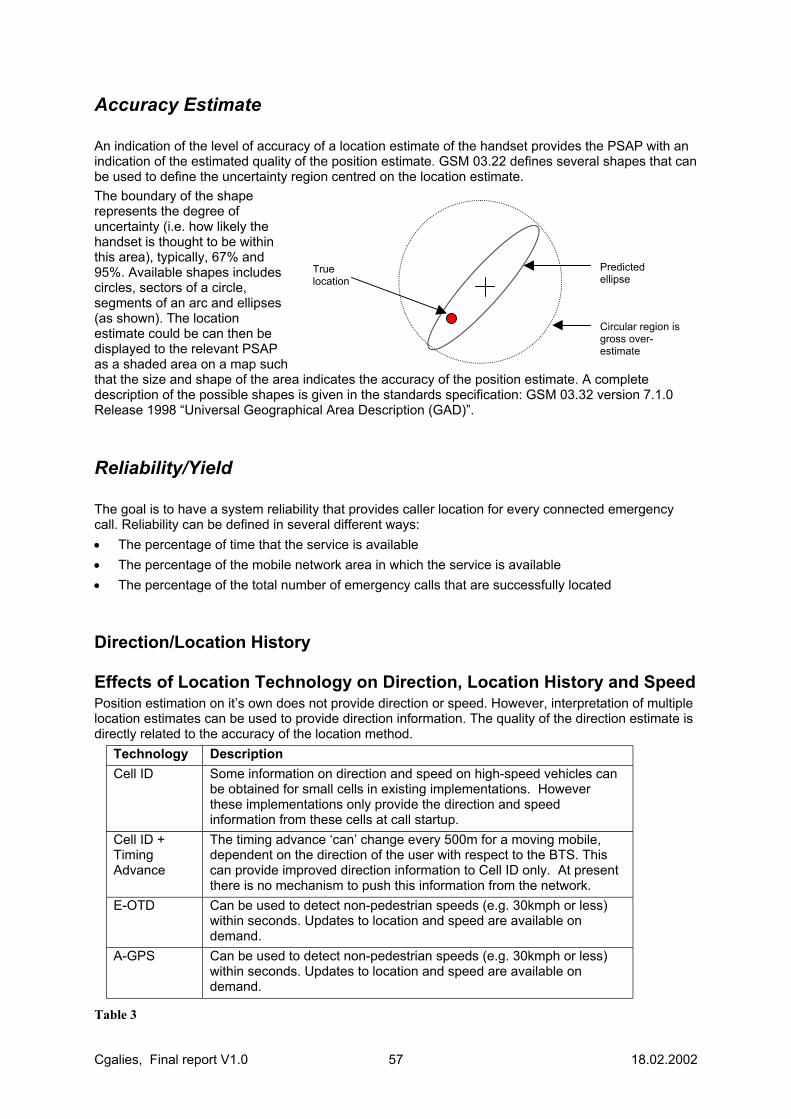
Cgalies, Final report V1.0 57 18.02.2002
Accuracy Estimate An indication of the level of accuracy of a location estimate of the handset provides the PSAP with an indication of the estimated quality of the position estimate. GSM 03.22 defines several shapes that can be used to define the uncertainty region centred on the location estimate. The boundary of the shape represents the degree of uncertainty (i.e. how likely the handset is thought to be within this area), typically, 67% and 95%. Available shapes includes circles, sectors of a circle, segments of an arc and ellipses (as shown). The location estimate could be can then be displayed to the relevant PSAP as a shaded area on a map such that the size and shape of the area indicates the accuracy of the position estimate. A complete description of the possible shapes is given in the standards specification: GSM 03.32 version 7.1.0 Release 1998 “Universal Geographical Area Description (GAD)”.
Reliability/Yield The goal is to have a system reliability that provides caller location for every connected emergency call. Reliability can be defined in several different ways: • The percentage of time that the service is available • The percentage of the mobile network area in which the service is available • The percentage of the total number of emergency calls that are successfully located
Direction/Location History
Effects of Location Technology on Direction, Location History and Speed Position estimation on it’s own does not provide direction or speed. However, interpretation of multiple location estimates can be used to provide direction information. The quality of the direction estimate is directly related to the accuracy of the location method.
Technology Description Cell ID Some information on direction and speed on high-speed vehicles can
be obtained for small cells in existing implementations. However these implementations only provide the direction and speed information from these cells at call startup.
Cell ID + Timing Advance
The timing advance ‘can’ change every 500m for a moving mobile, dependent on the direction of the user with respect to the BTS. This can provide improved direction information to Cell ID only. At present there is no mechanism to push this information from the network.
E-OTD Can be used to detect non-pedestrian speeds (e.g. 30kmph or less) within seconds. Updates to location and speed are available on demand.
A-GPS Can be used to detect non-pedestrian speeds (e.g. 30kmph or less) within seconds. Updates to location and speed are available on demand.
Table 3
Predicted ellipse
True location
Circular region is gross over-estimate
Cgalies, Final report V1.0 58 18.02.2002
Accuracy of speed and direction is related to accuracy of the position of the mobile. The faster the speed the more accurately it can be calculated. The denser the installed base of BTS, the better the accuracy for both Cell Id and E-OTD based systems. For Cell Id, the MS must move into another timing advance area or another cell for a measurement to be calculated. However, this may lead to inaccurate results as the mobile may camp on another cell giving a false velocity for Cell Id based systems. This analysis does not take into account any future developments in speed and direction technologies. For example, the Galileo could in future give speed from measured Doppler.
Recommendations Direction, speed and history of location fixes are useful parameters when the PSAP is handling a mobile call for help. These parameters would be used in the following situations: • Detection whether a caller is moving or static. • Establish whether the caller could is a Good Samaritan • Establish whether the caller is involved in the reported incident. • Locate the caller during a suspected kidnapping incident • Estimate speed and direction as an estimate of the position of the reported incident. • Determine which side of a carriageway an incident has occurred if the accuracy of the position
estimate is insufficient to do so. Direction information should be provided at the time the call is initiated. However, it is also acceptable that the direction estimate be provided as separate data update during the call or after call completion. As a part of standards development, there needs to be inclusion of the reporting of direction/speed information (if available) from the mobile to the network and ultimately to the PSAP.
Penetration The target is to be able to locate 100% of all handsets. For this purpose, a handset can be defined as any device that can be used to make a voice call to 112. Hence PDA’s, laptops, pagers, in-car panic buttons etc are not included in this target. It is recognised that 100% of all GSM handsets are capable of being positioned by Cell ID and Timing Advance today. For E-OTD and A-GPS solutions, new handsets are required. A target of 100% penetration of E-OTD or A-GPS capable handsets is unfeasible since users cannot be forced to change their terminals, but only encouraged to do so. However, there are very few old handsets (ie more than 4 years old) in use today and hence a high penetration is realistic. In addition, roaming handsets and those that do not comply with any future EU regulation must be accounted for. The United States regulations for emergency caller location allow a phasing-in approach for handset based technologies. These technologies are referred to as ALI (Automatic Location Identification)-capable handsets. There, the Federal Communication Commission have set the definition of full handset penetration to mean that 95% of all handsets are ALI-capable. The FCC also set the following dates for introduction of LCS capable handsets:
• Oct 2001 Begin fielding LCS capable handsets • Dec 2001 25% of new handsets must be LCS capable • Jun 2002 50% of new handsets must be LCS capable • Dec 2002 100% of new handsets must be LCS capable
It is not clear whether it is necessary to force LCS capable handsets to be available in set quantities in Europe. It is envisaged that subscriber demand for commercial services will make this unnecessary.
Cgalies, Final report V1.0 59 18.02.2002
The demand for commercial location services in Europe is expected to result in the introduction of location technologies into handsets and networks. The implementation of a particular technology is a commercial decision for each network operator. Should an operator choose to deploy a location technology, the expected penetration is described in the following sections. Note that the deployment of infrastructure upgrades depends on many factors including availability of the upgrade from vendors (hardware and software), new equipment from vendor, required geographical coverage and the quantity of BTSs to be upgraded. Availability can range from 12-36 months .
Cell ID 12-18 months are required to make the appropriate modifications in the network to provide Cell ID. No new terminals are needed.
Cell ID and Timing Advance 18-24 months are required to make the appropriate modifications in the network to provide Cell ID and Timing Advance. No new terminals are needed.
E-OTD Network elements to support E-OTD could be available in 12 months. Deployment within the network would then take an additional 12-18 months for limited coverage and 24 to 36 months for full service coverage. New terminals could include the necessary software changes in 12 to 24 months.
Standardised A-GPS (Basic) Network elements could be available in 12 months. New terminals would support Basic A-GPS in 2 to 4 years. The necessary hardware upgrade required may not be feasible in all terminals.
Standardised A-GPS (Full) Network elements could be available in 12 months. Deployment within the network would then take an additional 12-18 months for limited coverage and 24 to 36 months for full service coverage. New terminals would support Basic A-GPS in 2 to 4 years. The necessary hardware upgrade required may not be feasible in all terminals.
PSAPS The penetration of support by the PSAPs for emergency caller location is less clear, and will be subject to greater national variation. Introduction of new technology will be less problematic if it coincides with a planned upgrade. For example, in Sweden, it is planned to replace all equipment between 2003 and 2006, and addition support for caller location could be included. The expected availability of PSAP equipment for dealing with emergency caller location is 1-2 years.
Cgalies, Final report V1.0 60 18.02.2002
Time To Fix/Latency In general the Emergency services requirements are that an approximate position, such as that offered by Cell I.D., be available in less than 15 seconds, and that an accurate position estimate be available in less than 30 seconds.
Cell I.D Typically the time to first fix for Cell I.D. + T.A. is 1 to 2 seconds.
E-OTD Typically the time to first fix for Cell I.D. + T.A. is 5 to 10 seconds.
Assisted GPS The time to first fix for A-GPS is dependant upon the status of any pre-existing data held by the GPS receiver. These are classified as Cold Start, Warm Start and Hot Start.
Cold Start Cold start is generally defined as the condition whereby the receiver has only Almanac data, up to 1 week old. For A-GPS this is between 7 and 29 seconds
Warm Start Warm start is defined as the condition whereby the receiver has a previous position fix, an Almanac, and an Ephemeris older than 4 hours. For A-GPS this is between 6 and 29 seconds
Hot Start Hot start is generally defined as the re-acquisition of the Satellite signal - last signal contact or the stored data being less than 1 minute old. For A-GPS this is between 6 and 12 seconds
Coverage/Availability In terms of the Wireless Network, Cell I.D. + T.A. has 100% coverage and is available whenever a handset is ‘in call’. E-OTD coverage and availability is dependent on implementation planning – that is, the positioning of the LMUs. Theoretically coverage could be 100%, however in rural areas the lack of visibility to at least 3 transmitter sites could prove problematic. GPS coverage and availability is essentially worldwide. However, coverage and availability is impacted by the need to have radio visibility of at least 3 satellites. Signal blockage and degradation due to buildings and foliage severely restricts availability and indoor coverage is very limited even with A-GPS.
Cgalies, Final report V1.0 61 18.02.2002
Timescales Firstly, this section provides information on the current manufacturers' timetables regarding the product launch of location technologies and on the possible deployment timetables of network operators assuming that appropriate finance/business plans would be available in the same timeframe. Secondly, it highlights the timetables concerning the planning and implementation of PSAP equipment with the capabilities to utilise location information – again with the assumption that appropriate finance will be available. If the financial resources are not available these time-scales will slip.
Technologies Cell ID: Products are already available. However, EU-wide implementation of service is estimated to require still 1 –1½ year (e.g. starting mid 2002). • Cell ID+TA: Products are already available. Implementation can be built on the Cell ID technology
by complementing it with TA capability. Service launch is expected to take place in 2002 -2003. • E-OTD: Handsets will be launched in timeframe 1 – 2½ years. All new handsets are assumed then
to incorporate the E-OTD capability that requires a software upgrade and has only a marginal cost impact. Network products will be on the market at the same time. However, resulting from a considerable investment some network operators may not start rolling out service until E-OTD capable handsets are massively available. Therefore actual service launch is estimated to happen in 2½ - 4 years from now (2003 – 2005).
• A-GPS: Handsets with A-GPS functionality will be launched in 2 – 4 years. Network products are generally available in the same timeframe or earlier. In this case service deployment must precede handset launch due to the relatively high initial cost impact of GPS technology on terminals. In the first phase only certain high-end handset models are equipped with A-GPS functionality. This mechanism may lead to relatively slow rollout.
PSAPs The implementation of call location support for PSAPs is a substantial investment project requiring careful planning and adequate resources. The LIF and standardization organizations are drawing up specifications required for equipment procurement documents. These specifications are expected to be available in 2002. Another year is likely required for finalizing the procurement documents and to get approval for financing. This means that two years from now is needed providing that decision to implement location capability is made in 2001. Development and manufacturing of PSAP equipment is estimated to last two years. This timetable is based on presumption that the PSAPs of different Member States cooperate in drawing up requirement specifications hence creating a competitive market place. Installation and countrywide roll out new equipment is estimated to take up to two years.
Conclusions The deployment of location information in emergency services can start in four years (e.g. from mid 2005 onwards) providing that the PSAPs undertake necessary measures in a timely manner. Manufacturers are committed to launch handsets and network products to allow service rollout in the same time frame. Network operators are facing challenges in terms of setting priorities for their investments. This may lead to divergent service introduction timetables for different networks. Successful commercial services and competition are the key factors to speed up rollout of location based services.
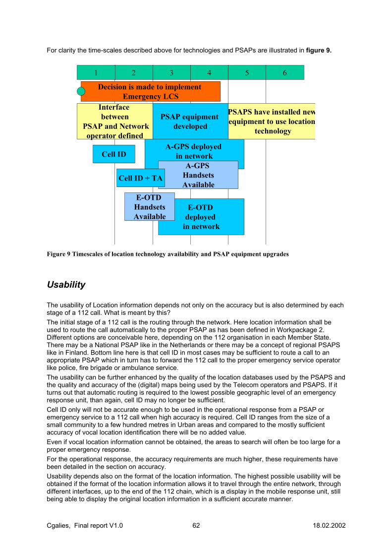
Cgalies, Final report V1.0 62 18.02.2002
For clarity the time-scales described above for technologies and PSAPs are illustrated in figure 9.
2 3 6541
E-OTD deployed
in network
A-GPS deployed in network
A-GPS HandsetsAvailable
Cell ID + TA
PSAPS have installed newequipment to use location
technology
Interface between
PSAP and Networkoperator defined
Decision is made to implement Emergency LCS
Cell ID
E-OTD HandsetsAvailable
PSAP equipment developed
Figure 9 Timescales of location technology availability and PSAP equipment upgrades
Usability The usability of Location information depends not only on the accuracy but is also determined by each stage of a 112 call. What is meant by this? The initial stage of a 112 call is the routing through the network. Here location information shall be used to route the call automatically to the proper PSAP as has been defined in Workpackage 2. Different options are conceivable here, depending on the 112 organisation in each Member State. There may be a National PSAP like in the Netherlands or there may be a concept of regional PSAPS like in Finland. Bottom line here is that cell ID in most cases may be sufficient to route a call to an appropriate PSAP which in turn has to forward the 112 call to the proper emergency service operator like police, fire brigade or ambulance service. The usability can be further enhanced by the quality of the location databases used by the PSAPS and the quality and accuracy of the (digital) maps being used by the Telecom operators and PSAPS. If it turns out that automatic routing is required to the lowest possible geographic level of an emergency response unit, than again, cell ID may no longer be sufficient. Cell ID only will not be accurate enough to be used in the operational response from a PSAP or emergency service to a 112 call when high accuracy is required. Cell ID ranges from the size of a small community to a few hundred metres in Urban areas and compared to the mostly sufficient accuracy of vocal location identification there will be no added value. Even if vocal location information cannot be obtained, the areas to search will often be too large for a proper emergency response. For the operational response, the accuracy requirements are much higher, these requirements have been detailed in the section on accuracy. Usability depends also on the format of the location information. The highest possible usability will be obtained if the format of the location information allows it to travel through the entire network, through different interfaces, up to the end of the 112 chain, which is a display in the mobile response unit, still being able to display the original location information in a sufficient accurate manner.

Cgalies, Final report V1.0 63 18.02.2002
Another aspect of usability is the operational use of the information. Next to vocal location information digital location information can be used to verify immediately upon reception the vocal information provided by the caller. This is the first check but at the same time it will enable the operator to interrogate the caller for the right location in case there is an instant mismatch between vocal and digital location information. Combined with additional applications, location information can be used to target if multiple calls refer to the same incident or not or to determine if a call is made by a “Good Samaritan”, if it can be distinguished if a vehicle is still moving. The direction and speed information of Good Samaritan calls can also be used to pinpoint the location of the incident, similar to dead reckoning in aviation (bearings from different positions and fixes).
Roaming/Interoperability Roaming is when a subscriber is able to use other cellular networks. This typically occurs if the subscriber travels to a different country from their home network. Interoperability is when different manufacturers’ equipment is able to function correctly with other manufacturers’ equipment. This aspect is important to many operators that have infrastructure provided by a number of different manufacturers. If the handset location capabilities match the location capabilities of the visited network then the visited network shall provide the same QoS as the home network. If the handset location capabilities do not match the location capabilities of the visited network then a minimum QoS must be guaranteed which is cellid. This scenario will be common during initial deployment of location services in member states. Equally, during initial deployment the location capabilities of the home network may vary according to rollout. A network operator shall provide a minimum QoS to all EU subscribers (home or visiting) on its network for Emergency Location Services. The minimum QoS shall be cell ID possibly upgrading to cell ID+TA later. For the more advanced methods of location the handset location capabilities are contained in the handset classmark. Due to the number of languages spoken within the EU and the extensive travelling that EU citizens do it is desirable that more than one language of the member states is supported at the PSAP. It may be desirable for the operator to inform the PSAP of the language preferences of the subscriber, if available, subject to clarification on regulations. However, the transmission of personal information to the PSAP has not been resolved. Another aspect of interoperability is that the PSAP network operator interface should be standardised across the EU. The interface between PSAP and network operator will be standardised. It is the responsibility of the PSAPs in the member states to use this interface. The necessary interfaces should be defined at the earliest possible opportunity to enable PSAPs and their suppliers to prepare. To address the problem of callers in one country connecting to a network in a neighbouring country’s network the transfer of calls, caller information and location between PSAPs across borders shall be supported. If the location indicates that the subscriber’s position is across a border, the network shall route the call to the appropriate PSAP in the other country, with user location and MSISDN/IMEI. There needs to be a high level of confidence it the indicated location before it is routed to a foreign PSAP. This requires co-operation between PSAPs that share border regions.
Cgalies, Final report V1.0 64 18.02.2002
Location Reference System There are a number of standard global co-ordinate formats and also local co-ordinate formats. The network operator should be able to deliver the position estimate in either a global co-ordinate format or a co-ordinate format local to the member state. The network operator shall not be required to support local co-ordinate formats from other member states. If electronic maps are employed at the PSAP for emergency services, they shall be accurate to 10m. This is the current industry standard and also complies with the best expected accuracy from location technology in mobile networks.
Proprietary in-car systems There are currently legacy in-car positioning systems that provide accurate user location to a private service centre. This service centre will contact the emergency services when an emergency service has occurred. Such proprietary in-car system will need to be considered in any proposed regulation on E112.
GPRS & 3G GPRS location technology will be similar to GSM location technology in performance and in the early stages of GPRS deployment GSM location services – even for Cell ID location. The network architecture for GPRS location services is not yet finalised in the standards, but is expected to be completed in Q1 2002 and with products be expected typically some 12 to 18 months later. UMTS location are also incomplete. A stable version of UMTS Release 4 which include location services is expected to be stable Q3 2001, with products to be expected 12 to 18 months later. The current UMTS location technologies defined in the standards are • Cell ID + Round Trip Time (RTT): Analogous to Cell ID +Timing Advance (TA) in GSM, however,
UMTS cells will be smaller than GSM cells and RTT is more accurate than TA • Assisted GPS (A-GPS) of comparable performance to A-GPS in GSM. • Observed Time Difference Of Arrival (OTDOA) a UMTS version of E-OTD with inferior
performance • Observed Time Difference Of Arrival – Idle Period Down Link (OTDOA-IPDL): a specific
implementation of OTDOA to improve performance to that of GSM E-OTD, whereby the base stations in the network are pulsed on and off. This implementation is unlikely to be considered by the network operators.
Future location technologies Future location technologies, are technologies that will be available in the long term and include E-OTD/A-GPS hybridisation, bluetooth and Galileo. These methods are described in the annex on new location technologies.

Cgalies, Final report V1.0 65 18.02.2002
Conclusions The main purpose of the WP1 workshops was to assess the requirements of the emergency services and to assess what is typically achievable by the standardised location technologies. The overlap between requirements and technology capability was then established. In this manner consensus and understanding was built on all issues. It was identified that there is not any location technology that will provide a complete solution to the problems faced by the emergency services in locating all calls and identifying all false calls. However, there was agreement that location technology could prove to be an important tool in improving the response time to emergency calls in many cases. There was also agreement that the PSAPs and the emergency service operatives will have to learn how to use these new tools in order to get the best usage out of location. During the accuracy analysis, it was recognised that there are three stages in the response to an emergency call that have different accuracy requirements - call routing, sending the call to the correct dispatch centre from the PSAP and finding the caller. Cell ID location technology is available in the short term with most, if not all, mobile network operators. It is expected that all operators in the EC will have this capability within 2 years anyway, so there are minimum cost implications to provide this service to the emergency services. Since Cell ID does not impact the handset, this means that Cell ID based location will be available to all European citizens in all networks in all member states - this is not true for any other technology and is likely to be so for foreseeable future. Also, when the more advanced technologies fail, Cell ID will always be available as a minimum accuracy. Cell ID accuracy can be enhanced with other measurements made in the network such as Timing Advance and neighbour site power level measurements at the handset. Overall it was difficult for the non 'emergency service' members of the group to assess the scale of the problem of there being no location information for emergency calls. Although a small number of individual cases were described to illustrate that location can be very useful in some scenarios, there seems to be no reports or data available to indicate how extensive such incidents are. Nor is there any information on the expected average response time increase to emergency calls if accurate location information is available. In light of this, it could prove to be very difficult to justify any regulation that would result in high costs, unless there is sufficient information on the extent of the problem and an assessment of what improvements location technology could realistically bring. Information was provided demonstrating that there are now more emergency calls from mobile phones than fixed lines mobiles (at least in some European countries), which does indicate that a re-assessment of the treatment of emergency calls made on mobile phones is a prudent approach. It is clear that a cost analysis needs to be performed by the operators, manufacturers and PSAPS at an early stage. This is the role of Work Package 3, but we constantly came back to this question in Work Package 1, because it places all other discussions in perspective. There is a need for a careful cost-benefit analysis from the European Commission as regulation will have very high financial impacts on emergency services and the telecoms industry. The more advanced location technologies that were considered, E-OTD and A-GPS, both require modified handsets. Handsets are likely to be available commercially, in volume, in 1-2 years for E-OTD and 2-4 years for A-GPS. Market forces and consumer demand will drive penetration of these handsets into the existing subscriber base. However, consumer uptake and willingness to pay for location technology in the handset is still unclear across Europe. The alternative to this is to set out a schedule to force availability of handsets ahead of consumer demand, similarly to the FCC mandate - but this will incur a high cost. Handset churn is unlikely to be more than 4 years for most subscribers, which is the approximate time for high penetration of the new technologies. For both E-OTD and A-GPS, the network upgrades are likely to be available within 12 months. However, the deployment time for the upgrades can range from 12 to 36 months, depending on the network and the implementation choice of the LCS technology.
Cgalies, Final report V1.0 66 18.02.2002
PSAPs reported a typical cycle time for equipment upgrades of 3-5 years. The time taken for the complete installation and commissioning of new equipment can range from 12-30 months. These figures will be significantly variable between the different member states. In general, the emergency services requirements on latency are that an approximate position (Cell ID is sufficient) is available in ~15 seconds, and a more accurate position estimate is available in ~30 seconds. Typically, the time to first fix for Cell ID + TA is 1-2 seconds, E-OTD is 5-10 seconds, A-GPS cold start is 10-30 seconds and A-GPS warm start is typically less than 20 seconds. The positioning technologies match the requirements well. The requirement from the emergency services on coverage is 100%. When asked to prioritise areas of coverage, there was agreement that the most important areas are highways. However, it was difficult to give further guidelines as the number of cases where location information is critical is a small percentage of calls, and is dependent on a high number of complex factors. This information is perhaps an indication that initial efforts should be focussed on highway coverage. Cell ID has 100% coverage, provided that a handset is connected to the network. E-OTD requires visibility to at least 3 transmitter sites, which makes coverage in rural areas problematic. A-GPS requires visibility to at least 3 satellites, which makes coverage indoors problematic. Both advanced positioning technologies can always fall back to Cell ID. A timeline was constructed describing the availability and deployment of location technology for the Network Operators and the availability and deployment of equipment for the PSAPs. This process was made with the assumption that there were no financial constraints. Importantly, consensus was reached on the timeline, and the availability of technology coincided well with the ability of the PSAP to use location information by the deployment of new equipment. The risks to location technology being deployed in the network on the above timeline and the appropriate equipment being deployed at the PSAP were then analysed. The risks were predominantly financial. For the network operator these risks are associated with deploying location services before an appropriate business plan is in place. For the PSAP the risks are associated with prioritising funds ahead of other important needs such as vehicles and personnel. Notably, there were several problems with usability that required further clarification from the EC on regulatory matters – specifically privacy. There needs to be clear an unambiguous direction from the EC on this controversial issue. Implicit in all this work is the assumption that when a caller rings 112, they are giving their permission for them to be located, even if they are reporting an incident in which they are not involved. PSAPs need to begin drafting user requirements and specifications as early as possible. To enable this to happen clear direction is required from the commission in a timely manner. It should be noted that the infrastructure to provide location information to the emergency services is the same regardless of the location technology. Therefore, if the system was set up to deliver Cell ID accuracy to the PSAPs at an early stage then there would not be the need for PSAPs to upgrade when the location technology changes to a higher accuracy method.
Cgalies, Final report V1.0 67 18.02.2002
Annex of new technologies
Hybrid E-OTD/A-GPS
Introduction WP1 has already reported that E-OTD can be less accurate in rural environments where visibility of base stations is limited. Overall, though the E-OTD/OTDOA method has better accuracy and availability in suburban and urban areas, in-vehicle and also provides indoor coverage. Similarly, GPS has no coverage where there is insufficient satellite visibility. Hence it will not work indoors except in limited areas where A-GPS provides additional sensitivity. GPS has better accuracy and availability in rural and sub-urban areas than in urban areas. A mobile terminal may incorporate both GPS and E-OTD capability, giving it the ability to use either method alone, or to combine ranging measurements from both methods in a ‘hybrid’ calculation (hence the term hybrid terminal). The combination can provide a better level of accuracy and wider coverage than either method alone. So, the hybrid method (Note 1) is based on combining E-OTD timing measurements and GPS range measurements made by the terminal – as outlined below.
The Hybrid Method Firstly we will consider how the E-OTD method works. At least three timing measurements made on the signals from geographically-diverse base stations are required for a point E-OTD horizontal position solution. An E-OTD position solution provides a two dimensional location estimate, and an estimate for the accuracy of the position described as an ‘ellipse of confidence’ representing the region of probability at a specified level (e.g. 95%) centred on the calculated position of the terminal. Further information on the E-OTD method is described in GSM03.71.
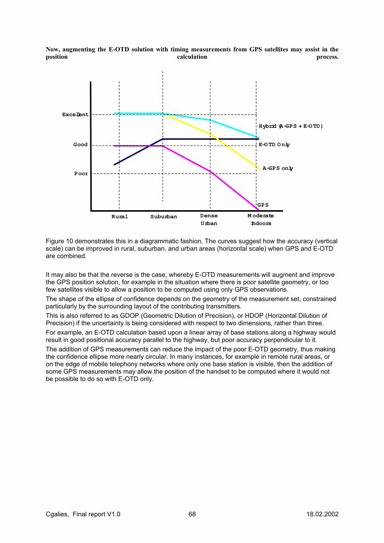
Cgalies, Final report V1.0 68 18.02.2002
Now, augmenting the E-OTD solution with timing measurements from GPS satellites may assist in the position calculation process.
Excellent
Good
Poor
Rural Suburban Dense
Urban
M oderate
Indoors
Hybrid (A-GPS + E-OTD)
E-OTD Only
A-GPS only
GPS
Figure 10 demonstrates this in a diagrammatic fashion. The curves suggest how the accuracy (vertical scale) can be improved in rural, suburban, and urban areas (horizontal scale) when GPS and E-OTD are combined. It may also be that the reverse is the case, whereby E-OTD measurements will augment and improve the GPS position solution, for example in the situation where there is poor satellite geometry, or too few satellites visible to allow a position to be computed using only GPS observations. The shape of the ellipse of confidence depends on the geometry of the measurement set, constrained particularly by the surrounding layout of the contributing transmitters. This is also referred to as GDOP (Geometric Dilution of Precision), or HDOP (Horizontal Dilution of Precision) if the uncertainty is being considered with respect to two dimensions, rather than three. For example, an E-OTD calculation based upon a linear array of base stations along a highway would result in good positional accuracy parallel to the highway, but poor accuracy perpendicular to it. The addition of GPS measurements can reduce the impact of the poor E-OTD geometry, thus making the confidence ellipse more nearly circular. In many instances, for example in remote rural areas, or on the edge of mobile telephony networks where only one base station is visible, then the addition of some GPS measurements may allow the position of the handset to be computed where it would not be possible to do so with E-OTD only.
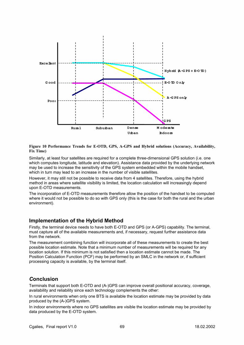
Cgalies, Final report V1.0 69 18.02.2002
Excellent
G ood
Poor
Rural Suburban Dense
Urban
M oderate
Indoors
Hybrid (A-G PS + E-O TD)
E-O TD O nly
A-G PS only
G PS
Figure 10 Performance Trends for E-OTD, GPS, A-GPS and Hybrid solutions (Accuracy, Availability, Fix Time)
Similarly, at least four satellites are required for a complete three-dimensional GPS solution (i.e. one which computes longitude, latitude and elevation). Assistance data provided by the underlying network may be used to increase the sensitivity of the GPS system embedded within the mobile handset, which in turn may lead to an increase in the number of visible satellites. However, it may still not be possible to receive data from 4 satellites. Therefore, using the hybrid method in areas where satellite visibility is limited, the location calculation will increasingly depend upon E-OTD measurements. The incorporation of E-OTD measurements therefore allow the position of the handset to be computed where it would not be possible to do so with GPS only (this is the case for both the rural and the urban environment).
Implementation of the Hybrid Method Firstly, the terminal device needs to have both E-OTD and GPS (or A-GPS) capability. The terminal, must capture all of the available measurements and, if necessary, request further assistance data from the network. The measurement combining function will incorporate all of these measurements to create the best possible location estimate. Note that a minimum number of measurements will be required for any location solution. If this minimum is not satisfied then a location estimate cannot be made. The Position Calculation Function (PCF) may be performed by an SMLC in the network or, if sufficient processing capacity is available, by the terminal itself.
Conclusion Terminals that support both E-OTD and (A-)GPS can improve overall positional accuracy, coverage, availability and reliability since each technology complements the other: In rural environments when only one BTS is available the location estimate may be provided by data produced by the (A-)GPS system. In indoor environments where no GPS satellites are visible the location estimate may be provided by data produced by the E-OTD system.
Cgalies, Final report V1.0 70 18.02.2002
In all cases, measurements from both methods can be combined to provide the best possible location estimate. The addition of E-OTD measurements permits an A-GPS handset to work with less than 4 satellites, enables a faster to search for satellites and improves transmitter GDOP. Industry initiatives are underway to determine potential accuracy improvements and to prove these in a variety of environments.
Notes The term ‘hybrid’ is also used (misleadingly) to describe positioning methods that require modifications to the handset and network. Most positioning methods require these modifications, whether in software or hardware. Although this introduction to the hybrid method references E-OTD, the method is equally applicable to OTDOA (Observed Time Difference of Arrival) as defined by 3GPP as the embodiment of E-OTD in 3G networks.
Bluetooth
Overview Bluetooth is a universal radio interface in the 2.45 GHz frequency band that enables portable electronic devices to connect and communicate wirelessly via short-range, ad hoc networks. Each unit can simultaneously communicate with up to seven other units per piconet.
Location Services The user with a Bluetooth enabled device can get the position information thanks to the fixed access points or also from a second mobile device which has very recently The user with a Bluetooth enabled device will be able to get the position information if an infrastructure of fixed access points or also a second mobile device which has very recently been within range of a Bluetooth device are nearby (less than 30 meters). . Thus, the deployment of Bluetooth fixed access points is required. The Bluetooth location technique is based in proximity (the positioning measurement is the coordinates of the nearest Bluetooth fix point to the handset). For location services, the main issue is that Bluetooth fix infrastructure is expected to be set up in city centres, office environment, shopping malls, railway stations and airports, tourist attractions, theme parks and museums, etc. These areas are the most problematic ones in accuracy issues. Hence, a Bluetooth solution in these areas could provide a highly accurate location positioning if the Bluetooth fixed infrastructure is implemented properly. The Bluetooth Special Interest Group (SIG) has identified 5 different Local Positioning usage scenarios. They are the followings: • The Bluetooth device determines its position, from one or more nearby devices. For instance, a
store has a network of Bluetooth devices to provide improved staff and customer capabilities, so providing a free indoor positioning service.
• Device learns and remembers its position. Crossing compatible Bluetooth devices, the mobiles learn their positions (because of the other devices carried a self-positioning device such as a portable GPS or Cellular Positioning terminal), and the handset effectively calibrates the infrastructure. The positions are remembered as long as the devices remain in touch and become available to any new visiting device.
Cgalies, Final report V1.0 71 18.02.2002
• Adaptive Interpolation between devices. A building contains many Bluetooth devices, the information propagates between the intermediate devices, which incrementally interpolate their individual positions.
• Power saving. A GPS terminal is brought into a Bluetooth environment and exchanges position information with the other devices. The Local Positioning then takes over and the GPS can be shut down or updated infrequently to save power.
• Bluetooth phone used in a car (with built in GPS). When GPS signals are unavailable, his cell-phone may use cellular positioning and pass the position on the cars GPS display, over Bluetooth. For real time local information and tracking applications, the car’s position information is passed from the GPS to the phone via Bluetooth and then over the cellular network. In an emergency situation, such as an air bag deployment, the phone can instigate an emergency call and pass on the car’s GPS position.
Network Impact It is necessary the deployment of the Bluetooth fixed access points that may be limited by cost considerations.
Handset Impact Bluetooth interface is a chip that will be embedded to the Handset. The position determination calculation could take place in the device, which has a service requiring this knowledge. Thus, the user device requires additional software. Power efficiency of Bluetooth Mobile Equipment (ME) is one of the discussions points. It needs to be evaluated.
Coverage This operation would only be activated in the ‘densely populated public spaces’. Strongly depending on the deployment of the fix Bluetooth infrastructure.
Accuracy The outcome of the operation provides a number representing the accuracy level of the estimate. The accuracy is estimated as the fix point range coverage. The accuracy depends strongly on the diffusion conditions of the environment.
Vertical Accuracy Usually, the level of indoor range coverage of a fix point is 3-30 m. Horizontal Accuracy One or two floors.
Reliability Reliability: Once the proper infrastructure is set up, the system provides you the accuracy level of the estimate.
Cgalies, Final report V1.0 72 18.02.2002
Time to Market (TTM) Bluetooth is quite a new technology. All available now are some studies and suggestions about the interface requirements for Location Based Services. The Bluetooth Local Positioning Working Group is working on this. Products on the market are expected are earliest 2002-2003.
Response Time Fastest technology.
Future trends It is felt that it would be useful to incorporate such position determination in the Bluetooth standard. As the infrastructure is progressively deployed, more and more services become possible, and there does seem to be a high potential for services using Bluetooth.
Galileo CS Commercial Service COSPAS Cosmicheskaya Sistemya Poiska Avariynich Sudov
(Space System for the Search of vessel in distress) EGNOS European Geostationary Navigation Overlay Service ESA European Space Agency Galileo European Satellite Navigation System GalileoSat Satellite constellation and associated Ground Segment GLONASS GLObal Navigation Satellite System GNSS Global Navigation Satellite Service GPS Global Positioning System ICAO International Civil Aviation Organisation IF Integrity Flag IMO International Maritime Organisation
Cgalies, Final report V1.0 73 18.02.2002
ITU International Telecommunication Union ITRF-96 International Time Reference Frame - 1996 LEO Low Earth Orbit MCC Mission Control Centre (SAR context) MEO Medium Earth Orbit MEO LUT MEO Local User Terminal (SAR context) OAS Open Service PRS Public Regulated Service RCC Rescue Co-ordination Centre SAR Search And Rescue SARSAT Search And Rescue Satellite Aided Tracking SOL Safety Of Life Service
Table 4 List of Acronyms
Galileo is a satellite navigation system which has been studied by the European Space Agency and the European Commission for several years. The related programme is now in its definition phase and a decision related to its effective implementation is expected by the European Transport Ministers Council in April 2001. The information presented in this document is mainly based on the results of the Galileo Overall Architecture Definition (GALA) study performed during the year 2000 for the European Commission. Galileo implementation responds to key societal needs related to the provision of location and time data to a large number of users. Many sectors will benefit from Galileo services, improving mobility and therefore quality of life in everyday travel and providing safety and efficiency to many activities related to professional and safety of life / security applications. At community level, Galileo is a key element in Europe’s policy to provide trans-European and global networks. In the economic area, Galileo is a means to develop in Europe the services related to navigation, which are estimated to become major market segments, and generate significant revenues. It will also support employment and maintain highly skilled jobs in Europe. From a strategic point of view, Galileo will bring independence to Europe in a domain mainly dominated by the United States with GPS.
Candidate Services The Galileo system will provide a word-wide (global) radio-electrical service allowing users equipped with a dedicated receiver to get their continuous and accurate real-time 3-D position and velocity information (according to ITRF 96 geodetic reference) as well as a Galileo reference time (according to Galileo System Time Scale). This global service will be possibly improved (accuracy, availability, integrity, etc.) in regional and local areas. As a result of an iteration process with the market analysis and system definition, the Galileo system will provide, as a baseline, three levels of navigation and timing services : 1. Open Services (OS), free for all users, providing positioning navigation and timing performances
comparable or better than those of existing and planned global navigation systems, 2. Commercial Services (CS), based on the open services signals, but providing value added
positioning navigation and timing data to users (e.g. integrity), with a liability regime, 3. Public Interest Services - certified services - for Safety Of Life (SOL) for transport and other
safety critical applications, Public Regulated Services (PRS) for the enforcement of Member States and EU policies implementation; and Search and Rescue (SAR) complementing COSPAS-SARSAT fort the detection of distress alarms from user beacons.
Cgalies, Final report V1.0 74 18.02.2002
Galileo Integrity Galileo will provide a set of services that include the provision of integrity information concerning Galileo satellites. This information is broadcast within Galileo signal in space from a subset of MEO satellites, on a global (world-wide) basis. In addition, regional services (outside Europe) can be provided through the implementation of regional components, based on integrity monitoring and control ground segments. The resulting integrity messages are sent to Galileo global component for broadcast within a reserved slot in the Galileo signal in space. The current definition of Galileo services assumes that the integrity information is protected for security and commercial reasons, therefore being encrypted, and reserved for authorised users only. It can be highlighted that even if Galileo services are based, in particular for integrity provision, on an architecture slightly different from the GNSS1 concepts, certification and standardisation concepts are the same as for EGNOS system.
Navigation Services and Performances Navigation Services The Open Service (OS) is defined for mass market applications and then shall provide by definition free of direct user charges access signals for positioning and timing. As for GPS, the OS shall not provide an integrity information computed by the system. Indeed, there is no commitment in relation to the quality of Open Service. The single and dual frequency OS are global : delivered world-wide. They are respectively called OS-G1 (for Global 1 frequency), OS-G2 (for Global 2 frequencies) and OS-GS (for Galileo OS-G2 signals with GPS SPS signals). The Galileo Commercial Service (CS) is defined for professional or scientist market applications which need a better service than OS and are ready to pay for it. The CS is broadcasting on a global basis (world-wide) an integrity information that controls the quality status of CS signals and sends an alarm to the user in case of problem in a very short delay (Time To Alarm in the range of 10 s). There will be a commitment on the quality of CS, if the user is using a CS certified terminal under normal conditions. This Global service is called CS-G. An alternative to this service consists in combining Galileo CS-G service with GPS SPS service and by also computing and distributing to users the integrity of GPS signals. This service is called CS-GS service (for Global and SPS). Safety of Life (SOL) considerations are important for nearly all transport applications but also for many non-transport applications. There is no common definition of the term “Safety of Life Requirement” among different Safety of Life applications. As a baseline, it is proposed to encrypt the SOL signals. With encryption, the security policy could be easily respected. The SOL services shall be free of direct charge for users and the encryption is not a means for payment of SOL services. In term of services, as for CS, the SOL can be delivered either Globally (SOL-G) based on a global integrity network with a Time to Alarm requirement of 6s to 15s, or Locally (SOL-L) with a time to alarm of 1s, the local differential correction being broadcast from local component via UHF-VHF links. Galileo intends to provide a world-wide service. However, for liability issues, it is proposed within Galileo architecture to offer a capacity for some regional services with the same level of performances through channels where the region authorities provide a status on Galileo performance to their users. Galileo is a civil system providing a robust service called PRS for the enforcement of Members States and EU policies implementation. This service will be used by several categories of users including military and other governmental communities (police, fire, ambulances, transport of nuclear waste, military, etc.). The control of this service will be ensured by civil bodies. The PRS shall be free of direct charge and limited to governmental users. Therefore three PRS are foreseen : PRS-G, PRS-L and PRS-GS. The requirements for each service to be provided are summarised in following table:
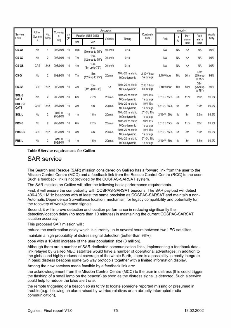
Cgalies, Final report V1.0 75 18.02.2002
Accuracy Integrity Position (NSE 95%) Service
Level
Other System
s
No. freqs
Coverage
(lat)
angle
Hor Vert Velocity Timing
Continuity Risk Risk TT
A Hor
alarm limit
Vert alarm limit
Availability
OS-G1 No 1 90S/90N 10 16m 36m (30m up to 75°) 50 cm/s 0.1s NA NA NA NA 99%
OS-G2 No 2 90S/90N 10 7m 15m (12m up to 75°) 20 cm/s 0.1s NA NA NA NA 99%
OS-GS GPS 2+2 90S/90N 10 4m 10m (8m up to 75°) 20 cm/s 0.1s NA NA NA NA 99%
CS-G No 2 90S/90N 10 7m 15m (12m up to 75°) 20cm/s
10 to 20 ns static 100ns dynamic
2.10-4/ hour 5s outage 2.10-7/ hour 10s 20m
45m (35m up to 75°)
99%
CS-GS GPS 2+2 90S/90N 10 4m 10m (8m up to 75°) NA
10 to 20 ns static 100ns dynamic
2.10-4/ hour 5s outage 2.10-7/ hour 10s 13m
32m (25m up to 75°)
99%
SOL-G CAT1 No 2 90S/90N 10 6m 7.7m 20cm/s
10 to 20 ns static 100ns dynamic
10-5/ 15s 1s outage
3.510-7/ 150s 6s 11m 20m 99.9%
SOL-GS CAT1 GPS 2+2 90S/90N 10 3m 4m 20cm/s
10 to 20 ns static 100ns dynamic
10-5/ 15s 1s outage
3.510-7/ 150s 6s 8m 10m 99.9%
SOL-L No 2 local in 90S/90N 10 1m 1.5m 20cm/s
10 to 20 ns static 100ns dynamic
5*10-6/ 15s 1s outage
2*10-9/ 150s 1s 3m 5.5m 99.9%
PRS-G No 2 90S/90N 10 6m 7.7m 20cm/s 10 to 20 ns static 100ns dynamic
10-5/ 15s 1s outage
3.510-7/ 150s 6s 11m 20m 99.9%
PRS-GS GPS 2+2 90S/90N 10 3m 4m 20cm/s 10 to 20 ns static 100ns dynamic
10-5/ 15s 1s outage
3.510-7/ 150s 6s 8m 10m 99.9%
PRS-L No 2 local in 90S/90N 10 1m 1.5m 20cm/s
10 to 20 ns static 100ns dynamic
5*10-6/ 15s 1s outage
2*10-9/ 150s 1s 3m 5.5m 99.9%
Table 5 Service requirements for Galileo
SAR service The Search and Rescue (SAR) mission considered on Galileo has a forward link from the user to the Mission Control Centre (MCC) and a feedback link from the Rescue Control Centre (RCC) to the user. Such a feedback link is not provided by the COSPAS-SARSAT system. The SAR mission on Galileo will offer the following basic performance requirements. First, it will ensure the compatibility with COSPAS-SARSAT beacons. The SAR payload will detect 406-406.1 MHz beacons with at least the same precision as COSPAS-SARSAT and maintain a non-Automatic Dependence Surveillance location mechanism for legacy compatibility and potentially for the recovery of weak/jammed signals. Second, it will improve detection and location performance in reducing significantly the detection/location delay (no more than 10 minutes) in maintaining the current COSPAS-SARSAT location accuracy. This proposed SAR mission will : reduce the confirmation delay which is currently up to several hours between two LEO satellites, maintain a high probability of distress signal detection (better than 98%), cope with a 10-fold increase of the user population size (3 million). Although there are a number of SAR-dedicated communication links, implementing a feedback data-link relayed by Galileo MEO satellites would have a number of operational advantages: in addition to the global and highly redundant coverage of the whole Earth, there is a possibility to easily integrate in basic distress beacons some two way protocols together with a limited information display. Among the new services made feasible by a feedback link are: the acknowledgement from the Mission Control Centre (MCC) to the user in distress (this could trigger the flashing of a small lamp on the beacon) as soon as the distress signal is detected. Such a service could help to reduce the false alert rate, the remote triggering of a beacon so as to try to locate someone reported missing or presumed in trouble (e.g. following an alarm raised by worried relatives or an abruptly interrupted radio communication),
Cgalies, Final report V1.0 76 18.02.2002
the faster transmission of more accurate distress signals, the broadcasting of messages to alert other users in the vicinity of a distress situation, so as to require them to contact the SAR authorities and co-ordinate distant SAR intervention (reducing SAR operational delays). Moreover the provision of beacon signalling enhancements, such as the additional user infraction (craft name and type, number of people onboard, onboard communication equipment), will enable to optimise SAR resource allocation. The considered frequency plan is the following : forward link : assignment, in the 1544-1545 MHz, of a channel at either end of the band, which has the advantage of being already a SAR assignment (beacon to satellite). feedback down-link (new service) : assignment of a slot in the navigation message (satellite to beacon).
Annex of Contributing Companies Heike Speckman Fire department Duisburg
Job J.Klijnhout ROSETTA project
Andrew Pickford Cambridge Positioning Systems
François BRANDON IRSM
Pekka Heikkinen Nokia
Jean-Claude Dardelet Alcatel
Per Palm SOS Alarm
Rob Davies One 2 One
Peter Salmon BT
Stephane Saada Alcatel
Frederic Collomb FDC
Han Hoekstra ITO
Carlos Rodríguez Casal OCUS
Tjerk Terpstra Department of Inner Affairs, Netherlands
Ralf Quint Ericsson
Erik Sundberg Telia
Vicky Keates Orange
Jean-Pierre Vincent Alcatel Space Industries
Juhani Jaaskelainen European Commission, DGINFSO
Jari Mannermaa Nokia
Hank Johnson BF Group
Aki Lumiaho Directorate-General Information Society European Commission
Pierpaolo PILLONI Telespazio
Salvatore VIVIANO Telespazio
Daniel Tewes 2 Mannesmann
Shahrzad Larger Ertico
Gemma Paris LOCUS
Sanjay Deshmukh Motorola
Eileen Boroski Lucent
Gary Pulford Lucent
Karsten Meinhold Siemens
Joerg Wissner E-Plus
Ralf Budde E-Plus Mobilfunk

Cgalies, Final report V1.0 77 18.02.2002
Colin Chandler Qualcomm
Bert Dorgelo Lucent
Paul Kompfner Ertico
Johan Blom Cellpoint
Brendan Ludden Vodafone
Tim Dunn Signalsoft Corporation
Joel de Decker Strategic Value
Francisco Puertas Telefonica Moviles Espana
Knut Viddal-Ervik Telenor
Larserik Axelsson National Post and Telecom Agency
Ruud Jonkman FELL
Jan Malenstein KLPD
Gemma Paris Motorola and LOCUS
Claire Alexandre Vodafone
Sian Evans Orange
Colin Chandler Qualcomm
Jan Vanvelk Belgacom
Annex of meeting dates Inaugural Work Package 1 meeting: 18th October 200 Minimum Requirements Workshop I: 5th & 6th December 2000 Horizontal Accuracy Vertical Accuracy Accuracy Estimate Reliability/Yield Direction/Location History
Workshop II: 31st January 2001 Penetration Time To Fix/Latency Coverage/Availability Workshop III: 27th February 2001 Usability Roaming/Interoperability Time-scales Initial Drafting Session: 28th February 2001 Decide framework for WP1 documentation

Cgalies, Final report V1.0 78 18.02.2002
11.2 ANNEX 2. QUESTIONNAIRE ON THE REQUIREMENTS OF NATIONAL CIVIL PROTECTION AUTHORITIES REGARDING THE LOCATION OF CALLERS IN EMERGENCY SITUATIONS (ENHANCED 112)
EUROPEAN COMMISSION DIRECTORATE-GENERAL ENVIRONMENT Directorate C - Nuclear safety and civil protection ENV.C.3 - Civil protection
Bruxelles, 21 December 2000 P:\alevantis\02-112\00112-18a.doc - 2000-12-08
FICHE DE TRANSMISSION DESTINATAIRES : - Membres du Réseau Permanent des Correspondants Nationaux
- Membres du Comité de Gestion en matière de Protection Civile
OBJET : Questionnaire sur les besoins des Autorités nationales de Protection civile en ce qui concerne la localisation des appels d'urgence (112)
REMARQUES : Dans le courant de cette année, les États membres on exprimé la nécessité de disposer de la localisation des appelants (atelier sur l'implémentation du 112 organisé à Luxembourg en mai 2000, conclusions de la 6ème réunion des Directeurs généraux de la Protection civile, tenue à Lisbonne en juin 2000).
Dans le cadre de la révision du cadre réglementaire des communications électroniques, la Commission a proposé en juillet 2000 que les entreprises qui exploitent des réseaux téléphoniques publics mettent, lorsque c’est techniquement faisable, les informations relatives à la position de l'appelant à la disposition des autorités intervenant en cas d'urgence, pour tous les appels destinés au numéro d'urgence européen '112'. Cette obligation couvrira à la fois la téléphonie fixe et mobile. (Les propositions de la Commission sont disponibles sur le site suivant: http://europa.eu.int/comm/information_society/policy/index_en.htm).
Aujourd'hui, il est techniquement possible de déterminer la position des appelants, y compris ceux qui utilisent des téléphones mobiles. Mais l'introduction réussie des nouvelles technologies et facilités pour le positionnement des appelants en cas d'urgence, nécessitera une collaboration entre le secteur public et le secteur privé en vue de l'établissement d'un consensus sur la stratégie d'implémentation.
Pour traiter des aspects liés à l'implémentation, les services de la Commission (DG Société de l'Information avec le soutien de la DG Environnement) ont établi un groupe de coordination de l'accès des services d'urgence aux informations de position des appelants. (des informations supplémentaires sur le travail de ce groupe sont disponibles sur le site www.telematica.de/cgalies). Le groupe comprend des représentants de l'industrie des télécommunications, des opérateurs de services de télécommunication, des fournisseurs de services d'information et des opérateurs des services d'urgence. Pendant les dernières réunions du RPCN, on vous a régulièrement informés quant aux travaux de ce groupe.
En vue de l'établissement de la faisabilité des solutions techniques possibles dans le domaine du positionnement des appelants et ses possibles implications, y compris le coût, il faudra clarifier et bien comprendre les besoins fonctionnels des autorités de la Protection civile. À cette fin, nous avons préparé le questionnaire ci-joint. Je vous prie de bien vouloir le compléter avant le 28 février 2001 et le

Cgalies, Final report V1.0 79 18.02.2002
retourner à l'Unité Protection civile (de préférence par courrier électronique à [email protected]). Veuillez noter que vos réponses pourront être utilisées publiquement sauf si vous demandez explicitement de les traiter comme confidentielles.
Les réponses à ce questionnaire aideront les services de la Commission à mieux évaluer vos besoins et les implications éventuelles de l'adoption des solutions possibles. Un rapport consolidé sera soumis pour discussion au RPCN.
Cgalies, Final report V1.0 80 18.02.2002
CORRESPONDENCE SLIP
ADDRESSEES : - Members of the Permanent Network of National Correspondents
- Members of the Management Committee for Civil Protection
SUBJECT : Questionnaire on the requirements of National Civil Protection Authorities regarding location of callers in emergency situations (112)
REMARKS : Earlier this year Members States expressed the need for the availability of caller location information (Workshop on the implementation of the 112 organised in Luxembourg in May 2000, Conclusions of the 6th meeting of directors-general for Civil Protection held in Lisbon in June 2000).
In the context of the review of the telecommunications regulatory framework, the Commission proposed in July 2000 that undertakings which operate public telephone networks make caller location information available to authorities handling emergencies, where technically feasible, for all 112 calls. This requirement would apply to both fixed and mobile telephony. (The texts of the Commission proposals are available at http://europa.eu.int/comm/information_society/policy/index_en.htm).
Today it is technically possible to determine the location of callers, including that of mobile phone users. But, successful introduction of new technologies and facilities for location determination in case of emergencies will require a public/private partnership to build consensus on the implementation strategy.
To deal with the implementation aspects, the Commission Services (DG Information Society with the support of DG Environment) set up a Co-ordination Group on Access to Location Information by Emergency Services. (More information on the work of this group is available at: www.telematica.de/cgalies). The group includes representatives of the telecommunications industry, telecommunications service providers, information service providers and emergency service operators. During the last few meetings of the PNNC, you were regularly kept informed about the work of this group.
In order to establish the feasibility of alternative technical solutions for location determination and the possible implications, including cost, the functional needs of Civil Protection authorities need to be clarified and fully understood. For this reason, we prepared the attached questionnaire. I kindly ask you to complete it by the 28 February 2001 and send it to the Civil Protection Unit (preferably by e-mail to [email protected]). Please note that your replies can be made publicly available unless you specifically request it that they should be treated confidentially. The replies to the questionnaire will help the Commission Services to better appreciate your requirements and the possible implications of choosing alternative solutions. A consolidated report will be submitted for discussion to the PNNC.
(signed)
Alessandro P. BARISICH Chef d'unité
Copy: Mme I. Garcia (EFTA secretariat) Mr. L. Koolen (DG INFSO)
Cgalies, Final report V1.0 81 18.02.2002
Questionnaire on the Requirements of National Civil Protection Authorities Regarding the Location of Callers in Emergency Situations (Enhanced 112)
Country: …
Name of respondent: …..
Function: …
Address: …
…
Tel: …
Fax: …
E-mail: …
This reply should reflect the co-ordinated views and requirements of all emergency services in the Member State i.e. of ambulances, police force, fire brigade and rescue services.
In order to establish a list of relevant persons to facilitate future co-ordination and an exchange of views and expertise in this field, we would appreciate it if you could fill out the name, function and contact details of those persons that participated in the formulation of your reply.
Name Function Tel Fax E-mail
Please return the replies to this questionnaire by e-mail to [email protected]
Cgalies, Final report V1.0 82 18.02.2002
Introduction
Today, approximately thirty percent (30 %) of emergency calls originate from a mobile phone and that percentage is growing. According to some statistics, more than sixty percent (60 %) of mobile callers in an emergency are not able to indicate their location. Of course, more emergency callers from the fixed network know their location but even for them some cases exist where the location can not be provided by the caller, for instance if the caller cannot speak (some statistics mention the figure of 2 %) or cannot give explanations in another language. In practice, this means that emergency services receive each year millions of calls for which the caller's location remains unknown or at least uncertain. This can have severe consequences, for the persons who are in an emergency situation and for the staff of the emergency services. The automated provision of the location of emergency callers might considerably improve the situation by enhancing the efficiency of emergency services and their response time whilst reducing strain of both victims and helpers. A recent study in Germany has indicated that this may result in significant benefits to society, in the form of cost-savings and other benefits17. The implementation of enhanced emergency services where the location is automatically forwarded, raises several issues such as what are the requirements, what technologies exist that can meet these requirements, what will be the cost, and who will commit the necessary investments. There is also a raft of legal issues such as how to protect the privacy of the users or what is the operator’s liability. This questionnaire will help the Commission to assess the scope of the problem and consolidate the requirements of civil protection authorities and emergency services organisations in Europe. As telecommunication markets and technological developments are increasingly international or even global in scope, the consolidated requirements may eventually lead to the harmonised introduction of location technologies across the European Union. In fact, the increased travel of European citizens (in 1999 more than 90 million people in the European Union crossed their national border) and the existence of a single European emergency call number 112 seem to require such common solutions.
17 Automatisches Notrufsystem - Positionspapier, ZVEI et al. (available on request - in German)
Cgalies, Final report V1.0 83 18.02.2002
Information about the scope of the problem This section aims at reaching a better understanding of the scope of the problem experienced by emergency services organisations.
1. How many emergency calls were made last year in your country?
2. How many of the calls under 1 were false emergency calls?
3. If several emergency numbers co-exist in your country, what is the percentage of callers who dialled 112?
4. Which percentage of emergency calls is received from mobile phones?
5. For which percentage of emergency calls from fixed phones could the caller not give a sufficiently accurate location to send a response?
6 For which percentage of calls from fixed phones the location information provided by the caller was later found to be incorrect or inaccurate leading to a considerable loss of time?
7. Which percentage of calls to the emergency services was accompanied by the transmission of the Calling Line Identity (CLI)?
8. Is Calling Line Identity (CLI) information used to verify the location of a fixed telephone (by reverse search in a database linking numbers to names and addresses)? Is this method accurate enough?
9. Do all emergency service centres have direct access to such a reverse search database? If not, which percentage does not have access and why not?
10 How much time would typically be saved for fixed calls if accurate location information was automatically available? If necessary, use a separate sheet to explain your answer.
11 For which percentage of calls from mobile phones, was the location information provided by the caller not accurate enough to send a response?
12 For which percentage of calls from mobile phones, location information provided by the callers was later found to be incorrect or inaccurate leading to considerable loss of time?
13 How much time would typically be saved for mobile calls if accurate location information was automatically available? If necessary, please explain your answer on a separate sheet.
14 How many emergency service response centres exist in your country?
15 How many of them would have to be upgraded in order to effectively process location information?

Cgalies, Final report V1.0 84 18.02.2002
16 How likely is it that they will be upgraded if location information would become generally available?
17 What would be the envisaged time schedule for such upgrading?
18 If you have any other statistical material that is relevant for the question of the transmission of location data and Calling Line Identity (CLI) to emergency service centres, please attach it.
Cgalies, Final report V1.0 85 18.02.2002
Location requirements for emergency calls from mobile phones Accuracy of location information The accuracy of the location information is an important parameter but it is certainly not the only parameter to be considered for the position determination of a person who is in an emergency situation. Other parameters like the direction that the person was travelling or the last known position of this person may also play an important role.
For example, a position information with an accuracy of 100 m is not sufficient to determine in which lane of a highway an accident occurred. But the position information with the same accuracy may be sufficient if the direction of travel of the vehicle is also provided. The required accuracy may also differ depending on the environment. For instance, an accuracy of 300 m may be sufficient in a rural area but not in a dense urban environment. Assuming that the location is the only information provided to emergency services, please indicate in the table below for each environment what your requirements are (one figure or a range).
If your requirement is different from the FCC Phase II requirements (see Annex), please explain in the comments column why a higher or lower accuracy is needed. You may also wish to indicate whether you need a vertical measurement or, for instance, how the accuracy requirement would change if direction information was provided.
Environment Accuracy required (meters)
Comments
Urban
Suburban
Rural
Indoor
Highway
Crossroads
Others (specify)
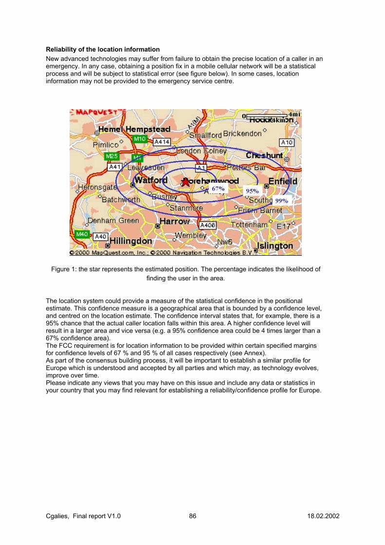
Cgalies, Final report V1.0 86 18.02.2002
Reliability of the location information New advanced technologies may suffer from failure to obtain the precise location of a caller in an emergency. In any case, obtaining a position fix in a mobile cellular network will be a statistical process and will be subject to statistical error (see figure below). In some cases, location information may not be provided to the emergency service centre.
Figure 1: the star represents the estimated position. The percentage indicates the likelihood of finding the user in the area.
The location system could provide a measure of the statistical confidence in the positional estimate. This confidence measure is a geographical area that is bounded by a confidence level, and centred on the location estimate. The confidence interval states that, for example, there is a 95% chance that the actual caller location falls within this area. A higher confidence level will result in a larger area and vice versa (e.g. a 95% confidence area could be 4 times larger than a 67% confidence area). The FCC requirement is for location information to be provided within certain specified margins for confidence levels of 67 % and 95 % of all cases respectively (see Annex). As part of the consensus building process, it will be important to establish a similar profile for Europe which is understood and accepted by all parties and which may, as technology evolves, improve over time. Please indicate any views that you may have on this issue and include any data or statistics in your country that you may find relevant for establishing a reliability/confidence profile for Europe.
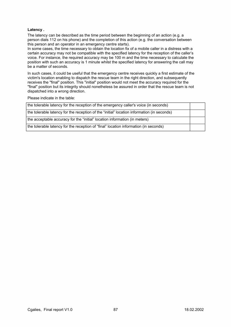
Cgalies, Final report V1.0 87 18.02.2002
Latency . The latency can be described as the time period between the beginning of an action (e.g. a person dials 112 on his phone) and the completion of this action (e.g. the conversation between this person and an operator in an emergency centre starts). In some cases, the time necessary to obtain the location fix of a mobile caller in a distress with a certain accuracy may not be compatible with the specified latency for the reception of the caller’s voice. For instance, the required accuracy may be 100 m and the time necessary to calculate the position with such an accuracy is 1 minute whilst the specified latency for answering the call may be a matter of seconds.
In such cases, it could be useful that the emergency centre receives quickly a first estimate of the victim's location enabling to dispatch the rescue team in the right direction, and subsequently receives the "final" position. This "initial" position would not meet the accuracy required for the "final" position but its integrity should nonetheless be assured in order that the rescue team is not dispatched into a wrong direction.
Please indicate in the table:
the tolerable latency for the reception of the emergency caller's voice (in seconds)
the tolerable latency for the reception of the “initial” location information (in seconds)
the acceptable accuracy for the “initial” location information (in meters)
the tolerable latency for the reception of “final” location information (in seconds)

Cgalies, Final report V1.0 88 18.02.2002
Other aspects common to fixed and mobile emergency calls Architecture Please give a brief description (one page) of the architecture of the system for emergency communications in your country.
The following items could be considered part of the description:
− Demarcation of responsibilities: who takes responsibility for what in the whole chain of providing an emergency service; who covers what cost etc.
− Call routing: use of dedicated trunks, existence of redundant routing or selective routing, automatic re-routing in case of network congestion of loss of an emergency centre, routing of exclusively voice or also data etc.
− Requirements and availability of any kind of automatically provided location information, for instance for fixed calls: for all operators? for all types of telephones?; is a call from a mobile treated differently?
− Databases: what databases exist, where are databases located, what redundancy is there?, how is integrity of data ensured?, who updates them? etc.
− Have any single points of failure within your emergency system been identified? How is this handled? etc;
− Language problems: if you receive an emergency call in a foreign language, how do you handle such a call, do you have access to special technical multi-lingual facilities etc.
Please feel free to provide any other information that you may find useful.
Cgalies, Final report V1.0 89 18.02.2002
Qualitative aspects Acknowledgement Please indicate whether a verbal acknowledgement to a caller in distress is necessary. If yes, please indicate whether the acknowledgement must come from the emergency services response centre, from local rescue service operator or from the mobile rescue team, or a combination of all.
Call-back facility Please indicate whether a call back facility would be needed, in case a connection is lost. If yes, please indicate who would need such a facility (central emergency response centre, local emergency service authorities such as police, fire brigade, medical emergency etc.).
Interface to in-car-systems Automatic emergency call initiation either (e.g. connected to the crash sensors in a car that steer the air-bags) will become common place in the future. Please indicate if you have specific procedures for handling such calls and/or specific requirements for the integration of such systems into your emergency services structure.
Information about the telecommunications Service Provider Please indicate whether you require information about which telecommunications service provider provided the service to the caller. If yes, please specify for what purpose and what type of information is sought.
Quantitative Aspects Disconnection Please indicate what is an acceptable probability of disconnection during an emergency call (i.e. how many disconnects out of every 100 calls?).
Routing accuracy What percentage of calls routed (voice and data) to the wrong emergency service response centre is acceptable?
System Availability Please indicate what level of unavailability is acceptable (expressed in minutes per year) of any component of your 112 system (e.g. emergency service response centre, voice and data network, selective routing switches, databases).
Cgalies, Final report V1.0 90 18.02.2002
Aspects related to the protection of privacy The possibility to determine the location of an individual who carries a mobile phone will raise important privacy questions. Besides the user, who may be directly affected, the mobile communications industry in Europe is greatly concerned about this issue as any mismanagement could jeopardise the achievements that result from long time commitments of the industry to guarantee users a high degree of data protection.
European law requires already that the privacy of individuals is adequately protected with full control by the user. In a proposal for the new regulatory framework, an exception might however be made for emergency services that would have an override possibility, allowing them to determine the location of a victim in an emergency, even if this would be against the specific instruction of the user.
The privacy of the individual must not be compromised by the development of new functionalities. It is therefore important that all parties involved in the service chain of an emergency call, including emergency service organisations, respect the same privacy rules and ensure the provision of the right level of privacy protection.
We would welcome any views that Member States may have on this topic.
Aspects related to the financing of enhanced emergency services Today, operators provide emergency calls free of charge for the user. Operators have installed and are maintaining the necessary supporting infrastructure for such calls in their network, at their own costs. Often, they are obliged to do so under the terms of their license.
However, the provision of enhanced emergency service will require significant investment in new systems, both by operators and emergency services. These costs can differ greatly according to the kind and level of requirements.
As regards the operators, mobile location determination systems may be expected to develop to serve the great commercial opportunities that location based services may offer. Hence, location information may become available as a by-product at no or little extra cost. However, in certain cases the accuracy may not be up to the same level as required by emergency services authorities.
In any case, any decision can only be made on the basis of a full cost-benefit analysis for which the cost aspect should be related to the scope of the implementation, the specific requirements of emergency services and the cost of technical location capabilities in the mobile networks.
Please provide any views that you may have about the financing of enhanced emergency services in the future.

Cgalies, Final report V1.0 91 18.02.2002
Annex
Requirements for Mobile Location Determination of the
US Federal Communications Commission (FCC)
In the US, the need to enhance emergency call services, in particular for calls originating from mobile phones, was recognised in the mid 1990’s under the threat of legal action. The result was a mandate of the Federal Communications Commission (FCC) which was adopted in 1996. The mandate requires operators to determine and forward the location of callers in an emergency.
The implementation of the mandate by operators met severe difficulties. As a consequence, the mandate needed to be revisited and was amended several times.
The present mandate foresees the introduction of a location capability in mobile communications systems in two steps:
• Phase I: wireless carriers have to deliver the telephone number and the location of the base station or cell site together with its radius of service in meters to the designated Public Safety Answering Point (PSAP).
• Phase II: is depending on the technology used: • the use of handset-based technology requires 50 m accuracy for 67% of calls, and 150 m
for 95% of calls; • the use of network-based technology requires 100 m accuracy for 67% of calls, and 300
m for 95% of calls. Phase II should be implemented by October 2001.
These latest requirements represent the result of several years of intensive debate between all parties involved. They may be considered to be reasonably balanced, taking into account the requirements of various emergency services authorities and interests of society and user groups on the one hand and the technological possibilities and costs on the other hand.
For more information, see for instance www.fcc.gov/e911 or www.nena9-1-1.org.

Cgalies, Final report V1.0 92 18.02.2002
11.3 ANNEX 3, PROPRIETY IN-CAR SYSTEMS Introduction of propriety in car systems will contribute to complicating the requirements of the emergency services beyond that achievable by handheld devices, there are benefits to gain, but also disadvantages to reflect on. The benefit to gain is the possibility to have a more accurate positioning, but this advantage will be taken over rather soon by GSM location technology. Another benefit seems to be the fact that additional data will be available but it remains to be seen how useful this is to standard PSAP operation. Possible additional data:
• Type of system. • Vehicle ID. • Vehicle data. • Crash impact sensor(s) data. • Number of persons. • Medical data. • Hazardous goods data. • "other" data to be defined or to emerge in the future.
It will be obvious that if it is going to be intended to implement these data on a Pan European scale, at least a common format and a kind of consolidated data dictionary has to be defined; otherwise these data will exist only as propriety data for each different system. Additional data need to be standardised! If we take into account that there also will e a growing need for a black box, similar to aviation, necessary to record system and performance parameters of on-board systems like Autonomous Cruise Control, Lateral course control etc , the matter will even be more complicated. What data need to be sent directly to an emergency service operator and what data may be safely stored for afterwards investigation? Another aspect to reflect on will be the role of the service provider to whom emergency calls may be forwarded by pushing the emergency or SOS button. Normally, if using a handset, 112 is dialled straight forward, looking like this: One dials 112 and is connected to a 112 PSAP. Even in the occasion that the handheld GSM has an emergency button (there are some!) this still will be dialling 112.
GSM handh
eld
112 centre
11
SOS

Cgalies, Final report V1.0 93 18.02.2002
Now, for in-car systems, it tends to be different:
Now there are two options to be considered here: Either 112 is stored under the button and thus one is connected to a 112 PSAP operator or one is connected to the service desk of the service operator. This can even be an "emergency " service desk. Notwithstanding this, if one is connected to a service operator on pushing the button, it is absolutely certain that 112 has not been dialled. Another phone number has been dialled instead. At this moment it is not clear if the users will be informed about this. There is a legitimate action here to be taken by the European Commission which is to oblige service operators to inform the users about this very clearly. It should be very clear to a user whether 112 is dialled on pushing an emergency/SOS button or another phone number. The bare concept of pushing a physical button marked "SOS" or "Emergency" might easily let the user believe that the emergency number 112 is dialled. Users should be clearly informed about this and ultimately, the user should have the choice. Still, there are some other items to reflect on concerning the issues of access to location information and Privacy. The oncoming legislation is fairly clear on this: Directive of the European Parliament and of the Council on Rights of Users and Obligations of Providers of Communications Services
Article 9 - Location data 1. Where electronic communications networks are capable of processing location data other than traffic data, relating to users or subscribers of their services, these data may only be processed when they are made anonymous, or with the consent of the users or subscribers to the extent and for the duration necessary for the provision of a value added service. The service provider must inform the users or subscribers, prior to obtaining their consent, of the type of location data which will be processed, of the purposes and duration of the processing and whether the data will be transmitted to a third party for the purpose of providing the value added service. 2. Where consent of the users or subscribers has been obtained for the processing of location data other than traffic data, the user or subscriber must continue to have the possibility, using a simple means and free of charge, of temporarily refusing the processing of such data for each connection to the network or for each transmission of a communication. 3. Processing of location data in accordance with paragraphs 1 and 2 must be restricted to persons acting under the authority of the provider of the electronic communications service or of the third party providing the value added service, and must be restricted to what is necessary for the purposes of providing the value added service. This is as clear as it can be with regards to privacy.
GSM in-car system
112 centre
98555
Service operator
112
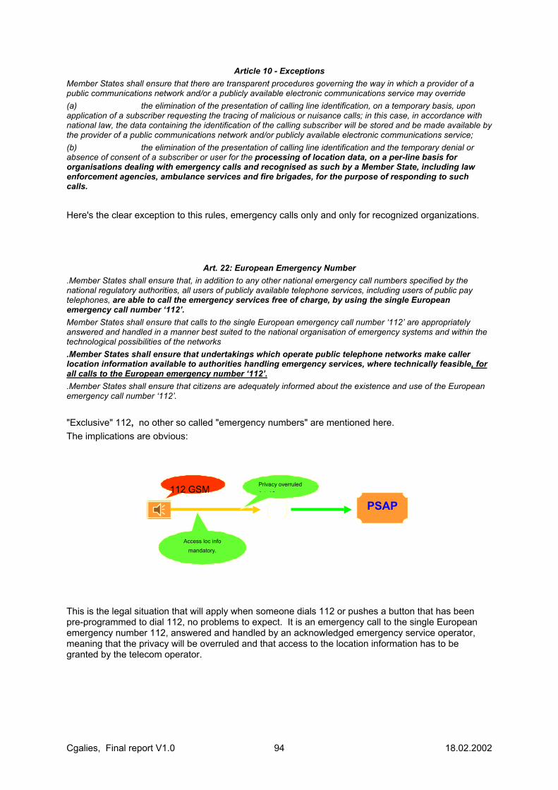
Cgalies, Final report V1.0 94 18.02.2002
Article 10 - Exceptions Member States shall ensure that there are transparent procedures governing the way in which a provider of a public communications network and/or a publicly available electronic communications service may override (a) the elimination of the presentation of calling line identification, on a temporary basis, upon application of a subscriber requesting the tracing of malicious or nuisance calls; in this case, in accordance with national law, the data containing the identification of the calling subscriber will be stored and be made available by the provider of a public communications network and/or publicly available electronic communications service; (b) the elimination of the presentation of calling line identification and the temporary denial or absence of consent of a subscriber or user for the processing of location data, on a per-line basis for organisations dealing with emergency calls and recognised as such by a Member State, including law enforcement agencies, ambulance services and fire brigades, for the purpose of responding to such calls.
Here's the clear exception to this rules, emergency calls only and only for recognized organizations.
Art. 22: European Emergency Number
.Member States shall ensure that, in addition to any other national emergency call numbers specified by the national regulatory authorities, all users of publicly available telephone services, including users of public pay telephones, are able to call the emergency services free of charge, by using the single European emergency call number ‘112’. Member States shall ensure that calls to the single European emergency call number ‘112’ are appropriately answered and handled in a manner best suited to the national organisation of emergency systems and within the technological possibilities of the networks .Member States shall ensure that undertakings which operate public telephone networks make caller location information available to authorities handling emergency services, where technically feasible, for all calls to the European emergency number ‘112’. .Member States shall ensure that citizens are adequately informed about the existence and use of the European emergency call number ‘112’. "Exclusive" 112, no other so called "emergency numbers" are mentioned here. The implications are obvious:
This is the legal situation that will apply when someone dials 112 or pushes a button that has been pre-programmed to dial 112, no problems to expect. It is an emergency call to the single European emergency number 112, answered and handled by an acknowledged emergency service operator, meaning that the privacy will be overruled and that access to the location information has to be granted by the telecom operator.
PSAP
Access loc info mandatory.
Privacy overruled A t 10 112 GSM

Cgalies, Final report V1.0 95 18.02.2002
Now, reflect on this:
Quite the opposite. In the initial stage where no connection is made to an acknowledged emergency service operator no overruling of privacy is possible or allowed and there is no obligation to grant access to location information for the telecom operator. This can seriously affect the second stage of these kind of calls where the service provider has to forward the call to an emergency service operator. What will apply then and how to complete missing data like location information and personal data of the caller? This definitely needs to be addressed by the European Commission to prevent that citizens in distress may face situations that there can be no adequate response because of this. There are two more issues that need to be addressed as well. The first is the capacity of operating/computer systems of service providers. As lessons from the past have already been learnt on this it should be an absolute demand that on the issue of responding to emergency calls by commercial service operators, the capacity of systems and human resources always must be able to cope with unusual circumstances like disasters, overall bad weather conditions seriously inflicting road traffic and other unforeseen conditions that may cause extremely peaks in emergency communications. It will not be acceptable that citizens are faced with the fact that there simply will be no response at all on an emergency call because of insufficient capacity to handle or to process incoming emergency calls. This equally applies to the forwarding end to standing emergency service operators of a first reception frond end commercial service provider. The second issue is also arising from lessons learnt in the past by emergency service operators. It concerns the fact that it has proven to be absolutely necessary to train emergency service operators to handle persons in distress. On many occasions it will be experienced that people in distress will not be able to provide comprehensible information or need to be re-assured in order to prevent situations worsening. Operators will have to be trained on this, next to the ability to handle foreign languages, this is a very under estimated subject. In the USA FCC rules that these two items should be fully covered by commercial service providers. It is advised to have a similar ruling on this on a Pan European level as well.
Service Provide
SOS /emergency Button, no 112
Access loc info not mandatory.
Art 22
Privacy rules
PSAP
112 or? What applies?

Cgalies, Final report V1.0 96 18.02.2002
11.4 ANNEX 4. LIST OF CGALIES MEMBERS. Last Name First Name Company
ABEND Uwe Motorola GmbH, Commercial Government & Industrial Solution Sector ABRAHAM Denis TDF ALEVANTIS Panagiotis CEC ALEXANDRE Claire GSM Europe / Vodafone Group ANNUNZIATO Armando Telecom Italia ARIF Ziya GEMINUS / RACAL AVIONICS Ltd ARIMANY Juan Intrado AUGELLO Daniel Renault / Strategic and Product Planning International Operations AXELSSON Lars-Erik NATIONAL POST AND TELECOMS AGENCY BALLETTA Pierluigi Telespazio BAUMANN Stefan TELEMATICA BERGED Hans Internationella frågor BILLINGSLEY Saul AIT & FIA BLANK Oliver EICTA BLOM Johan CellPoint Europe BLOM Marnix KPN Mobile BORGSTROM Owe European Commission - DG INFSO BOROSKI Eileen Intrado BORTEN Kristian National Telecom Agency BRANDON François IRSM BREITHUBER Christian Federal Ministry of the Interior - Telecommunication Unit BUDDE Ralf E-Plus Mobilfunk GmbH BUECHTER Martin Deutsche Telekom Mobilnet GmbH CAPELLEMAN Charles ARC Transistance S.A. CARDOSO Marcelo Positron Public Safety Systems Inc. CARPENTER Paul LUCENT Technologies CAUBET Claude SETRA – CSTR, METL / Min. Transports CHANDLER Colin QUALCOMM Europe SARL CHEBLI Nayla Webraska CLARK Barry Scotland Yard CLAYTON Michael ETSI COLLOMB Frederic FDC CROOK Mick ORANGE DARDELET Jean-Claude Galileo Industries DAVIES Philip LOGICA UK/ Space and Defense DAVIES Robert One2One DE CLERCQ Els EENA / Cabinet of Telecommunications Belgium DE DECKER Joel Strategic.Value, Ltd DE MATEO Mariluz AENA DE TROYER Koen Proximus DE WAEL James Belgacom DEBECKER J.L. ETNO DECLERCK Paul Motorola Inc DESHMUKH Sanjay Motorola Inc. DIEN Hai Phong Max.mobil DOORN Piet NL Police DORGELO Bert EICTA / Lucent Technologies DRICOT Fabienne CEC

Cgalies, Final report V1.0 97 18.02.2002
DRU Marie-Anne Alcatel - Mobile Communication Division DUBOIS Bernard ARC Transistance S.A. DUNN Timothy SIGNALSOFT EDSTAM Anders The Swedish Rescue Service Agency EVANS Sian Orange EYLERT Bernd UMTS Forum FERRER Ruben H. Positron Public Safety Systems Inc. FISCHER Günther Max.mobil FOSHAUG Rune TELENOR FREIJ Ghassan ERTICO GAILLET Jean-François Webraska GAVIN Craik ETSI GELLEE Eric FDC GENET Jean-Jacques Nortel Networks / GSM LCS & E911 PLM GIANNOTTI Marco Telecom Italia Mobile GIREAU Simon Bouygues Telecom GONZALEZ Isabel Positron Public Safety Systems Inc. GRAY Tony RCC Consultants GUSTAFSSON Mats The Swedish Rescue Services Agency, Command & Technical
Department, Command & Control Systems Section HANNA Joe Directions HARCQ Jean-François Belgacom HEATH David OFTEL HEIDENREICH Sören FEU - Federation of the EU Fire Off. Ass. HEIKKINEN Pekka EICTA / Nokia HEINE Gunnar INACON HEININK Bart KPN Mobile HELLERSTROM Ann-Marie Internationella frågor HILL Martin Home Office, Fire and Emergency planning Directorate HIRECHE Mohamed Ascom Multimedia & Pay Systems Division HOLLINGSWORTH Michael ACEA HUMMELSHEIM Klaus ERTICO/TeleAtlas HUSSON Patrice CEC JÄÄSKELÄINEN Juhani CEC JÄÄSKELÄINEN Mikko Ministry of the Interior JAGO Gordon SIGNALSOFT JAGOMAGI Teet MGINE Technologies JARN Anette Telia Mobile R&D JENSEN Peter Lüppert Tele Danmark A/S JOHNS B ASA JOHNSEN Kjell Telenor Bruxelles SA JOHNSON Hank HBF Group B.V. JOLIE Marie-Josée CEC JONKMAN Ruud FEU - Firefighters JUSTINGER Michael Ministerium fur Inneres und Sport KARAMITSOS Fotis CEC KASTIES Günther OECON KEATES Vicky ORANGE KERVERN Georges-Yves KEUTER Alfons Deutsche Telekom Mobilnet GmbH KLIJNHOUT Job J. Rijkswaterstaat AVV KOMPFNER Paul ERTICO KOOLEN Leo CEC KOREHNKE Stephan Mannesmann Mobilfunk GmbH
Cgalies, Final report V1.0 98 18.02.2002
KRAMER Juliet GSM Europe / One2One KREDTER Dennis Deutsche Telekom Brussels Representative Office KRUSCH Wilhelm ETNO / Deutsche Telekom KYRK Åsa Swedish Rescue Services Agency LAGERWAARD G.E. Lagerwaard Projecten LAITAT Hervé Belgacom Mobile / MDG-Mobile Data Group LAURSEN Lars L. Siemens Mobile Phones A/S LAVROFF Jean-Louis CEC LECHAT Claude EICTA / Alcatel LECHNER Wolfgang LOCUS PROJECT LOPES Luis MOTOROLA LUDDEN Brendan VODAFONE LUMIAHO Aki CEC MABILLE EENA / Telecommunications Ministry of Belgium MADIA John Intrado MAES Willy CEC MALENSTEIN Jan NL POLICE MALMBAK Per Motorola GmbH MALMROS Steffen NORDTEL/Tele Denmark MANNEKENS Henk BT MANNERMAA Jari NOKIA MOBILE PHONES MAURO Isabelle GSM Association MC CLELLAN Sally CellPoint Europe MEDEIROS Francisco CEC MEDLAND John ETNO / BT MEINHOLD Karsten EICTA / Siemens MOORE Linda Congressional Research Services MORANDINI Olivier Paul EENA MORRIS Paul Cambridge Positioning Systems Ltd MUNRO Ian Cambridge Positioning Systems Ltd NAFEI Yasser Motorola Inc./Technology Strategy and Planning/Advanced Technology
and Software Operations/Personal Communications Sector NARDIN Philippe Ministère de l'Intérieur NIELSEN Michael NORSTAD Kristina Ericsson Radio Systems AB OTTO Hans-Ulrich Tele Atlas N.V. PALM Per SOS Alarm Sweden PARIS Didier Services D'Incendie et de Secours D'Eure et Loir PAULINE Roger Texas Instrument PELLEGRINO Carole Bouygues Telecom PICKFORD Andrew Cambridge Positioning Systems Ltd PILLONI Pierpaolo Telespazio PINKARD David Lucent Technologies, UK. PORTER Nicole Helios Technology ltd PUERTAS Francisco Telefonica Mobiles España PULFORD Gary Lucent Technologies PYRROS Demetrios EKAB / National Centre of Emergency Care QUINT Ralf Ericsson Radio Systems AB RALPH Daniel BT RAULT André EUCAR / ACEA RAVIGLIONE Cesare Fiat Auto / Product Engineering/ITS projects REDMOND Albert ODTR REMY Jean-Gabriel Cegetel RINGOTTE Georges Services D'Incendie et de Secours du Vaucluse
Cgalies, Final report V1.0 99 18.02.2002
REPUSSARD Jean-Paul DG TREN ROBINSON Rhys TruePosition, Inc. RODRIGUEZ Carlos Public University Of Navarra ROSENSKJOLD Christian National Telecom Agency ROSU Livia ETSI ROUDIER Lydie Bouygues Telecom ROY Andre EENA SAADA Stephane Alcatel France SAGE Andrew Helios Technology ltd SAHNOUN Rym France Telecom SALMON Peter BT SANDSTROM Urban CELLPOINT SYSTEMS AB SANSONE Fulvio ERTICO SC SCHEPERS Herman BT Cellnet SCHMALKOKE Erwin POLICE / MOI SCHULZ Gerhard FEU SCHWARTZ-SORENSEN Charlotte National Telecom Agency SHACHAM Niv Accucel Technologies SHEYNBLAT Len SnapTrack, A Qualcomm Company SMETS Jan Intergraph Public Safety Belgium N.V. SMITH David C BT SOLIN Marina One 2 One SPECKMANN Heike FEU - Feuerwehr Duisburg STRAUSS Roland Siemens AG SUNDBERG Erik. G. Communicator SUTHERLAND Ewan INTUG TANGUY Stephane Nortel Networks / Wireless Service Network TAPIA Mario Telecomsys TEEMANT Juri Estonia Mobile Telephone Company Ltd TERPSTRA Tjerk Department Inne Affairs Neth. TEWES Daniel Mannesmann Mobilfunk GmbH TIPPLE James BT Cellnet (Mobile telecoms) VAN BASTEN BATENBURG Rutger GSM Europe VAN DEN BERG Bénédicte Cabinet of Minister of Foreign Affairs of Belgium VAN DEN BROECK Wouter FEU (Brandweer Lebbeke / Fire brigade) VAN DEN HEUVEL Jeroen KPN VAN ESSEN Rob Tele Atlas NV VANVELK Jan Belgacom Mobile VIDDAL-ERVIK Knut TELENOR VILLIER Eric MOTOROLA VINCENT Jean-Pierre Alcatel Space Industries VINCENT Nicolas ALCATEL VISSER Symon Strategic.Value, Ltd VITALBO Marc Ministère de l'Intérieur VIVIANO Salvatore Telespazio WEERASEKERA Indaka Lucent Technologies WEVERS Kees NavTech WISSNER Joerg E-Plus ZARRI Michele One2One Personal Communication Ltd ZILLIKENS Frank Nokia Mobile Phones (WAP FORUM) ZIMMERMANN Peter Management Consultant


![SKELETON - ETSI · Web viewSTF 473 . Task 1.4 . Working Document v1.0. MAMES Message Definition [Authors: STF 473] < TECHNICAL SPECIFICATION Reference Keywords](https://static.fdocuments.us/doc/165x107/5e64d59cdb396b753c64d21c/skeleton-etsi-web-view-stf-473-task-14-working-document-v10-mames-message.jpg)
