CENTRAL AVENUE CONNECTOR TRAIL FEASIBILITY STUDY AND IMPLEMENTATION PLAN
11
CENTRAL AVENUE CONNECTOR TRAIL FEASIBILITY STUDY AND IMPLEMENTATION PLAN April 2016 Central Avenue Metro Blue Line TOD THE MARYLAND-NATIONAL CAPITAL PARK AND PLANNING COMMISSION PRINCE GEORGE’S COUNTY PLANNING DEPARTMENT
-
Upload
maryland-national-capital-park-planning-commission -
Category
Documents
-
view
218 -
download
2
description
Â
Transcript of CENTRAL AVENUE CONNECTOR TRAIL FEASIBILITY STUDY AND IMPLEMENTATION PLAN

CENTRAL AVENUE CONNECTOR TRAILFEASIBILITY STUDY AND IMPLEMENTATION PLAN
April 2016
Central AvenueMetro Blue Line
TOD
THE MARYLAND-NATIONAL CAPITAL PARK AND PLANNING COMMISSIONPRINCE GEORGE’S COUNTY PLANNING DEPARTMENT
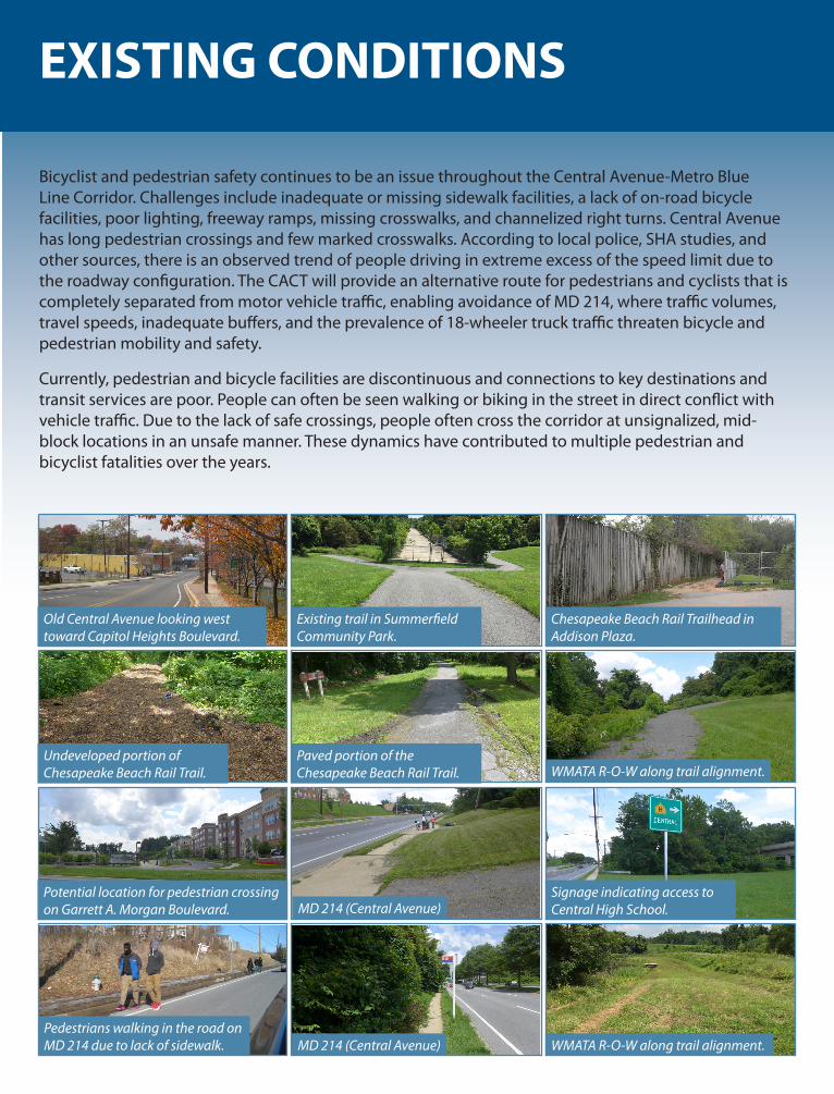
EXISTING CONDITIONS
Bicyclist and pedestrian safety continues to be an issue throughout the Central Avenue-Metro Blue Line Corridor. Challenges include inadequate or missing sidewalk facilities, a lack of on-road bicycle facilities, poor lighting, freeway ramps, missing crosswalks, and channelized right turns. Central Avenue has long pedestrian crossings and few marked crosswalks. According to local police, SHA studies, and other sources, there is an observed trend of people driving in extreme excess of the speed limit due to the roadway configuration. The CACT will provide an alternative route for pedestrians and cyclists that is completely separated from motor vehicle traffic, enabling avoidance of MD 214, where traffic volumes, travel speeds, inadequate buffers, and the prevalence of 18-wheeler truck traffic threaten bicycle and pedestrian mobility and safety.
Currently, pedestrian and bicycle facilities are discontinuous and connections to key destinations and transit services are poor. People can often be seen walking or biking in the street in direct conflict with vehicle traffic. Due to the lack of safe crossings, people often cross the corridor at unsignalized, mid-block locations in an unsafe manner. These dynamics have contributed to multiple pedestrian and bicyclist fatalities over the years.
Old Central Avenue looking west toward Capitol Heights Boulevard.
Existing trail in Summerfield Community Park.
Paved portion of the Chesapeake Beach Rail Trail. WMATA R-O-W along trail alignment.
Chesapeake Beach Rail Trailhead in Addison Plaza.
Undeveloped portion of Chesapeake Beach Rail Trail.
Potential location for pedestrian crossing on Garrett A. Morgan Boulevard. MD 214 (Central Avenue)
Signage indicating access to Central High School.
Pedestrians walking in the road on MD 214 due to lack of sidewalk. MD 214 (Central Avenue) WMATA R-O-W along trail alignment.

VISION/DESIGN PRINCIPLES
VisionInput from the M-NCPPC project team, Prince George’s County residents, elected officials, and agency representatives was used to develop the following Vision Statement for the Central Avenue Connector Trail. The trail alignment was carefully conceived to achieve this vision.
The Central Avenue Connector Trail is a safe and comfortable connection to the four Metrorail stations, neighborhoods, employment locations, shopping and entertainment venues, and existing or planned trails, especially those that lead to parks and recreation facilities. The trail improves the overall public well-being and economy of the Central Avenue-Metro Blue Line Corridor and promotes bicycling culture within it. Community members feel safe using the trail and consider it an important asset to the neighborhood.
Design Principles and MethodologyDiscussions with the trail’s stakeholders also led to the development of a set of Design Principles, which are intended to guide the design, construction, maintenance, and operation of the trail.
The trail serves as a major connection for regional mobility. The Connector Trail will serve as a major trail (or spine facility) as part of the broader County/regional trail system.
The trail will be part of the neighborhood walking and bicycling networks.A complete pedestrian and bicycle network is comprised of several facility types such as trails, low-volume streets, and streets with sidewalks and off-road connections. While these facilities are designed and built at different times and have varying ownerships, collectively they form a critical part of the transportation system: the pedestrian and bicycle network. The trail will be part of this network.
The primary facility type will be a multi-use trail.The primary facility type will be a multi-use trail, with other designs used in certain sections as appropriate. To the extent possible, the Connector Trail will follow the Metrorail alignment and connect to current or planned trails that lead to valued community destinations. The trail will be designed as a multi-use trail along MD 214 (Central Avenue) where the existing public right-of-way allows.
The alignment and design will aim to maximize directness, access, safety, and ADA-compliance.Each of these elements will contribute to a trail that is usable by those living, working and visiting the Central Avenue-Metro Blue Line corridor. Safety and ADA-compliance are the most important factors in designing the trail, and will be particularly important at roadway crossings. It will be critical to work with local stakeholders to identify a final design that provides a high-quality experience for users while maximizing project resources.
Encourage natural surveillance for trail safety.The trail’s design and operation will serve community needs for transportation and recreation, while also supporting an improved sense of place. Regular maintenance and police patrols will lead to an improved sense of safety, which in turn will help contribute to increased trail usage. Increased usage provides “natural surveillance” for the trail, minimizing risk for users.
PROJECT OVERVIEW
The Central Avenue Connector Trail (Connector Trail) is being planned to complement the ongoing economic, community, and cultural revitalization of the Central Avenue-Metro Blue Line Corridor, which includes four Metrorail stations: Capitol Heights, Addison Road-Seat Pleasant, Morgan Boulevard, and Largo Town Center. The Maryland-National Capital Park and Planning Commission (M-NCPPC) is in the implementation phase of the planning effort, which seeks to stimulate economic development and make the Corridor a highly desirable location for commercial and residential development. The Connector Trail is envisioned as an important element of the revitalization effort, serving to improve transit access, link with the broader County/regional trail network and improve connections between local destinations. The Connector Trail is also envisioned as an important recreation destination and a valued community asset.
Key opportunities and challenges related to the implementation of the proposed alignment include:
Opportunities• The majority of the alignment runs along property owned by M-NCPPC, the Washington Metropolitan
Area Transit Authority (WMATA), and the Maryland State Highway Administration (MDSHA).• Significant sections of the proposed alignment exist on undeveloped land that offer open site lines,
provide a direct path of travel to Metrorail stations, and could accommodate a 12-foot-wide multi-use trail.
• The Central Avenue-Metro Blue Line Corridor’s rich history is in part untold; the trail can include educational kiosks and other elements that celebrate the history, ecology, and culture of the area.
• Several locations exist for complementary programming or amenities alongside the trail (e.g., immediately west of the Morgan Boulevard Metro Station and west of Cindy Lane on the south side of Central Avenue), including locations on M-NCPPC and WMATA property.
Challenges• There are environmental concerns along some portions of the proposed trail alignment, especially
along Old Central Avenue and the Chesapeake Beach Rail Trail.• Several stream valley crossings will require bridges, which is likely to increase construction costs.• Some portions of the proposed alignment travel along private property.• The proposed alignment would necessitate a bridge across the I-495/Capital Beltway near Largo
Town Center Metro Station, which will require a significant level of effort and cost. An alternative alignment which would not require a bridge is provided; however, this alternative is more circuitous for users.
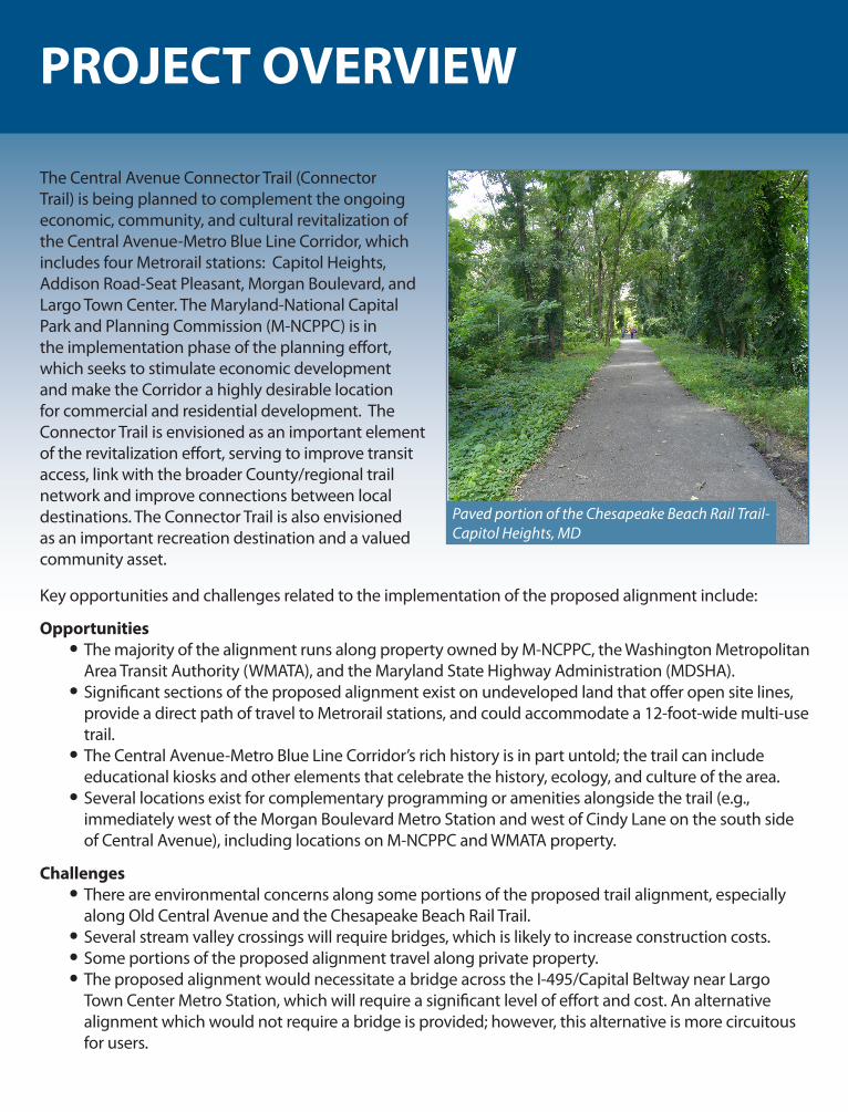
Paved portion of the Chesapeake Beach Rail Trail-Capitol Heights, MD
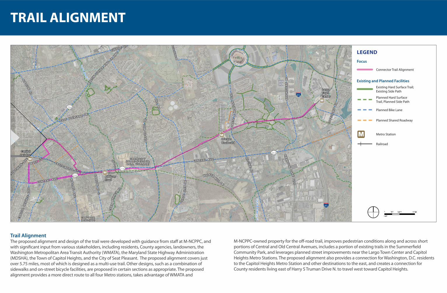
TRAIL ALIGNMENT
Trail AlignmentThe proposed alignment and design of the trail were developed with guidance from staff at M-NCPPC, and with significant input from various stakeholders, including residents, County agencies, landowners, the Washington Metropolitan Area Transit Authority (WMATA), the Maryland State Highway Administration (MDSHA), the Town of Capitol Heights, and the City of Seat Pleasant. The proposed alignment covers just over 5.75 miles, most of which is designed as a multi-use trail. Other designs, such as a combination of sidewalks and on-street bicycle facilities, are proposed in certain sections as appropriate. The proposed alignment provides a more direct route to all four Metro stations, takes advantage of WMATA and
M-NCPPC-owned property for the off-road trail, improves pedestrian conditions along and across short portions of Central and Old Central Avenues, includes a portion of existing trails in the Summerfield Community Park, and leverages planned street improvements near the Largo Town Center and Capitol Heights Metro Stations. The proposed alignment also provides a connection for Washington, D.C. residents to the Capitol Heights Metro Station and other destinations to the east, and creates a connection for County residents living east of Harry S Truman Drive N. to travel west toward Capitol Heights.
Focus
LEGEND
Existing and Planned Facilities
Connector Trail Alignment
Existing Hard Surface Trail; Existing Side Path
Planned Hard Surface Trail, Planned Side Path
Planned Bike Lane
Planned Shared Roadway
Metro Station
Railroad

DESIGN FEATURES/PROGRAMMING
Trail Design and FeaturesThe following four facility types are used along the corridor:
• 12-foot multi-use trail with 2-foot buffer on each side
• 10- to 12-foot sidewalk with buffer where possible
• 6-foot sidewalks with parallel, on-street bicycle facilities (shared lane markings, wide bike lanes or bike lanes)
• 12- to 16-foot multi-use trail bridge, used where needed to bridge stream valleys and wetlands. 12-foot boardwalks with railings may also be used in or near these areas
Opportunities for InterpretationThe Prince George’s County Historical Society may be well-positioned to help develop interpretive elements as part of the Connector Trail, emphasizing themes including the area’s evolving development characteristics, the role of Metro in the community, the Chesapeake Beach Rail Trail, the East Corner Boundary Stone, and others.
SignageSignage is a critical element of any successful trail and can serve several purposes including providing maps, wayfinding, and mile markers for users; promoting the trail to people walking or driving by entrances; explaining trail rules and etiquette; or making note of cultural or historical points of interest. Regulatory signage is also critical, for example, to alert drivers and trail users of upcoming intersections. A comprehensive trail signage program should be developed to include both informational and regulatory signage and to avoid “sign clutter,” which can become distracting and unattractive.
Boundary marker between Prince George’s County and Washington, D.C. Trail guidelines and wayfinding signage.
Potomac Yard Park Trail in Arlington, VA.

DESIGN FEATURES/PROGRAMMING
ADA ComplianceTrails that comply with the Americans with Disabilities Act provide a high-quality experience for all community members, regardless of their abilities. Ensuring ADA compliance along the Connector Trail will improve access to the four Metro stations within the Central Avenue-Metro Blue Line Corridor.
Safety FeaturesTrail user safety has been identified as a high priority by those participating in stakeholder and community meetings. Crime Prevention Through Environmental Design (CPTED) principles should inform the design and operation of the Connector Trail.
LightingAdequate lighting extends trail use at the beginning and end of the day and increases visibility during cloudy days when there is low natural light. Equally important for trail users is the sense of safety that a well-lit trail provides.
Trail crossing in College Park, MD includes desired ADA features. The center split helps reduce congestion between trail users traveling in each direction. Solar-powered lights along a trail.
Vertical Connection includes ADA-compliant switchback and steps along the Potomac Yard Park Trail. Call boxes need to be highly visible.
Call BoxesEmergency call boxes are a valuable component of trail safety in that they facilitate an emergency response when needed, increase the trail user’s perceived safety, and may deter crime.
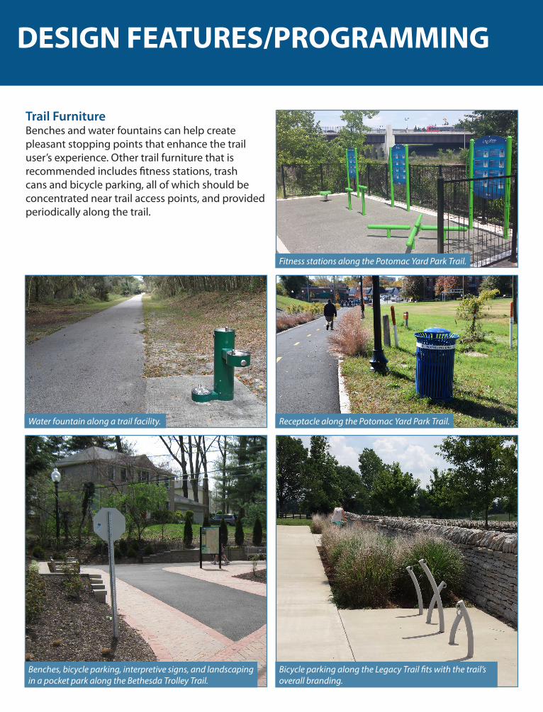
Trail FurnitureBenches and water fountains can help create pleasant stopping points that enhance the trail user’s experience. Other trail furniture that is recommended includes fitness stations, trash cans and bicycle parking, all of which should be concentrated near trail access points, and provided periodically along the trail.
Benches, bicycle parking, interpretive signs, and landscaping in a pocket park along the Bethesda Trolley Trail.
Water fountain along a trail facility. Receptacle along the Potomac Yard Park Trail.
Fitness stations along the Potomac Yard Park Trail.
Bicycle parking along the Legacy Trail fits with the trail’s overall branding.
DESIGN FEATURES/PROGRAMMING

COMMUNITY ENGAGEMENT
Stakeholder Input and Public EngagementStakeholder engagement was an important part of the development of the Central Avenue Connector Trail alignment and vision. Two agency stakeholder meetings and two community meetings occurred during the study period between February and June 2015.
Key Stakeholder CommentsAlignment
• The trail should offer the shortest and safest connection to Metrorail stations
• The trail should use the existing right-of-way (R-O-W) where possible
• The trail should connect to parks and other existing or planned trails
Design and Safety• Roadway crossings should be safe and
comfortable for pedestrians and bicyclists, especially those across Central Avenue
• Lighting should allow for safety and 24-hour access to the trail
• The trail should have open sight lines for visibility
Implementation• Trail planning and implementation should
take advantage of funding opportunities• The trail should be built in segments• The trail should be realistic and constructible
Key Comments from Community MembersDesign Considerations
• Ensure accommodation for all users, especially youth and seniors
• Connect to Walker Mill Park, the Sports and Learning Center, Millwood Park, Peppermill Recreation Center, and other local destinations
• Improve the streetscape along Central Avenue
Safety Needs• Minimize user conflicts between bicyclists
and pedestrians• Safety features of the trail should include
cameras• Privacy for those living adjacent to the trail
needs to be considered and addressed
Programming Recommendations • Include space for outdoor performances• Include bicycle parking• Include attractions for people of all ages
and abilities
Other Concerns and Recommendations• Engage with private property owners
directly affected by the proposed trail alignment as part of the implementation process
• Encourage more young people to attend the public meetings and get their buy-in
Small group discussions at the June 16, 2015 public meeting.
A total of 230 community members attended the February 26, 2015 Open House.

IMPLEMENTATION
The Central Avenue Connector Trail is planned in five phases based on several factors, including their relative potential to improve transit access and other factors that determine ease of implementation (e.g., property ownership, level of investment needed within the public right-of-way, and complexity of topographical or environmental issues).
Next StepsThe project team conducted a planning-level evaluation of project costs and timeline for preliminary engineering (30 percent design). It is estimated to take approximately 15 months to complete environmental permitting and preliminary (30 percent) design for any given phase or sub-phase. This estimated schedule is dependent on timely review of preliminary plans and permit documents by participating agencies. Preliminary discussions with environmental permitting agencies will begin during preliminary design, but are expected to extend well into the future final design phases. The required environmental permitting activities may be dictated by the planned design features of the trail, and also by funding sources used to finance the design and construction.
1
5
234
Metro Station
Railroad
Implementation Phase OtherLEGEND

GET INVOLVED!
The Central Avenue Connector Trail has the potential to become a prized community asset in Prince George’s County and to support the broader revitalization efforts underway in the Central Avenue-Metro Blue Line Corridor. Implementation of the Central Avenue Connector Trail is feasible but will require a sustained partnership between a number of agencies. Chief among those partners will be M-NCPPC, Prince George’s County, WMATA, MDSHA, the Town of Capitol Heights, and the City of Seat Pleasant. Strong leadership from M-NCPPC staff and the area’s elected officials will also be essential, particularly given the long-term implementation timeframe of this project. Furthermore, continuing to engage the community during trail design and implementation will build a foundation of public support and ownership, potentially establishing a growing body of supporters who may help maintain, program, sustain, and enliven the trail over time.
Additional Information:If you would like to learn more about this project or you want to get involved please contact staff in the Strategy and Implementation Office, Prince George’s County Planning Department, The Maryland-National Capital Park and Planning Commission.
Project ContactsVanessa Akins, Chief, Strategy and ImplementationJordan Exantus, Planner Coordinator, Strategy and Implementation
Contact InfoPhone: 301-952-3594 TTY: 301-952-4366
Information On-lineLink to the Full Central Avenue Connector Trail Report:https://issuu.com/mncppc/docs/cactfinal
Link to the Central Avenue Connector Trail Project Website:http://www.pgplanning.org/Projects/Ongoing_Plans_and_Projects/Community_Plans_and_Studies/CACT.htm