CENTER FOR ENERGY STUDIES - Louisiana State … FOR ENERGY STUDIES ... Inflatable Packers and ......
46
1 CENTER FOR ENERGY STUDIES BOSSIER BOSSIER - - HAYNESVILLE HAYNESVILLE SHALE: SHALE: NORTH LOUISIANA SALT BASIN NORTH LOUISIANA SALT BASIN D. A. GODDARD, E. A. MANCINI, D. A. GODDARD, E. A. MANCINI, S. C. TALUKAR & M. HORN S. C. TALUKAR & M. HORN Louisiana State University Baton Rouge , Louisiana
Transcript of CENTER FOR ENERGY STUDIES - Louisiana State … FOR ENERGY STUDIES ... Inflatable Packers and ......

1
CENTER FOR ENERGY STUDIES
BOSSIER BOSSIER -- HAYNESVILLE HAYNESVILLE SHALE: SHALE: NORTH LOUISIANA SALT BASINNORTH LOUISIANA SALT BASIN
D. A. GODDARD, E. A. MANCINI, D. A. GODDARD, E. A. MANCINI, S. C. TALUKAR & M. HORN S. C. TALUKAR & M. HORN
Louisiana State UniversityBaton Rouge , Louisiana

2
OVERVIEWOVERVIEWRegional Geological SettingRegional Geological SettingTotal Organic Carbon & RockTotal Organic Carbon & Rock--EvalEvalPyrolisisPyrolisisKerogenKerogen PetrographyPetrographyThin Section PetrographyThin Section PetrographyNaturally Fractured Shale ReservoirsNaturally Fractured Shale ReservoirsConclusionsConclusions
3
Gulf Coast Interior BasinsGulf Coast Interior Basins
Gulf Coast Interior Salt Basins
Mancini and Puckett, 2005

4
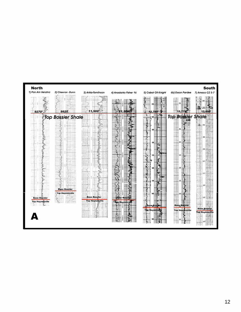
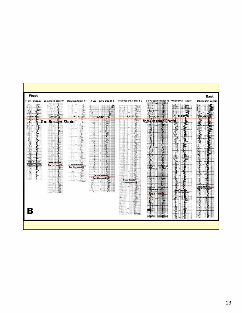
TYPE LOG

5
Type Wells

6
Bossier Parish Wells
7
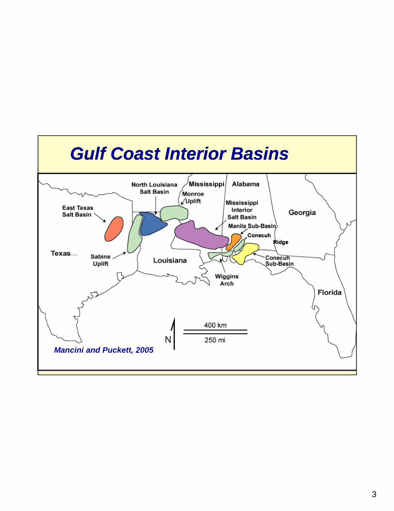
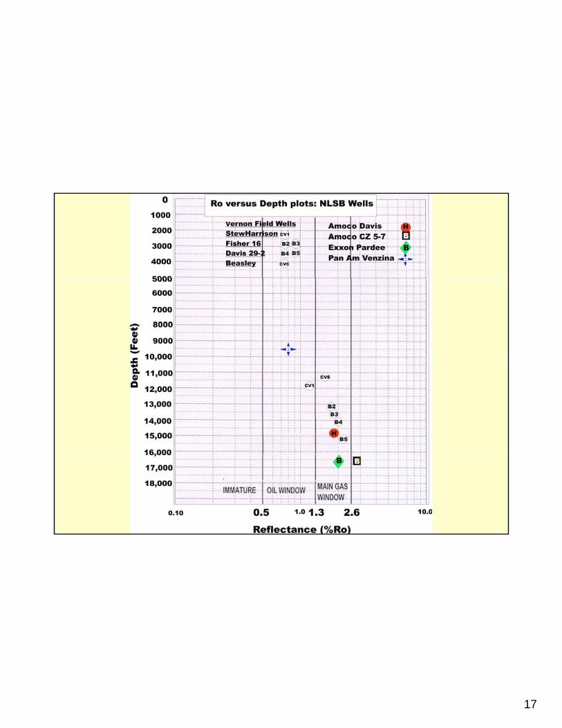
BossierBossier--Haynesville samples in NLSB .Haynesville samples in NLSB .
(LA Parish) Sample(Serial #) OP/Well Name Core Interval Depth-Ft
(Jackson) 10,944(162291) AMOCO Davis Bros Bossier Fm 10 945(162291) AMOCO Davis Bros. Bossier Fm. 10,945
10,948Haynesville Fm. 12,804
12,95612,976
(164798) AMOCO CZ 5-7 (Winn) 15,601Bossier Fm 15 608Bossier Fm. 15,608Haynesville Fm. 16,413
16,41816,43116,432
(166680) EXXON Pardee (Winn) 16195Bossier Fm 16 200Bossier Fm. 16,200
16,400
(107545) Venzina Green #1 (Union) 9,347Bossier Fm. 9,357
9,372

8
9
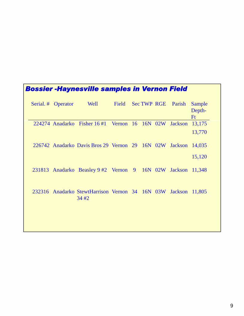
Bossier -Haynesville samples in Vernon Field
Serial. # Operator Well Field Sec TWP RGE Parish Sample Depth-Ft
224274 Anadarko Fisher 16 #1 Vernon 16 16N 02W Jackson 13,17513,770
226742 Anadarko Davis Bros 29 Vernon 29 16N 02W Jackson 14,035
15,12015,120
231813 Anadarko Beasley 9 #2 Vernon 9 16N 02W Jackson 11,348
232316 Anadarko StewtHarrison Vernon 34 16N 03W Jackson 11,80534 #2

10
Modified from Structuremaps.com

11
12
13

14
WellDepth
(Ft)%
Ro SampleTOC Wt
%S1
mg/gS2
mg/gS3
mg/g Tmax HI OI S1/TOC PI TAIAMOCO DAVIS Cotton V. 10,944 0.46 0.14 0.12 0.09 331 26 20 30 0.54AMOCO DAVIS Cotton V. 10,945 0.25 0.04 0.04 0.12 442 17 46 17 0.49
Analytical results of Total Organic Carbon, RockAnalytical results of Total Organic Carbon, Rock--EvalEvalPyrolysisPyrolysis, and , and VitriniteVitrinite Reflectance (Ro) in the NLSB.Reflectance (Ro) in the NLSB.
AMOCO DAVIS Cotton V. 10,948 0.11 0.02 0.04 0.11 424 35 98 18 0.33
AMOCO DAVIS Haynesville 12,956 0.43 0.1 0.08 0.22 304 19 20 43 0.56 3.5-3.7 1.73 AMOCO DAVIS Haynesville 12,976 0.61 0.11 0.07 0.02 313 11 3 18 0.61 3.5-3.7 1.77
AMOCO CZ 5-7 Bossier 15,601 0.27 0.04 0.06 0.13 375 21 50 15 0.42AMOCO CZ 5-7 Bossier 15,608 0.28 0.02 0.04 0 307 14 0 7 0.33AMOCO CZ 5-7 Haynesville 16,413 0.23 0.04 0.05 0.14 379 22 58 18 0.45AMOCO CZ 5-7 Haynesville 16,418 0.34 0.05 0.07 0.11 355 21 32 15 0.42
AMOCO CZ 5-7 Haynesville 16,431 0.34 0.06 0.1 0.37 329 29 109 18 0.38 3.7-3.8 2.62AMOCO CZ 5 7 Haynesville 16 432 0 28 0 05 0 09 0 15 375 31 55 18 0 37AMOCO CZ 5-7 Haynesville 16,432 0.28 0.05 0.09 0.15 375 31 55 18 0.37
EXXON PARDEE Bossier 16,195 0.19 0.18 0.27 0.12 370 147 62 96 0.39EXXON PARDEE Bossier 16,200 0.35 0.21 0.29 0.29 322 83 83 60 0.42
EXXON PARDEE Bossier 16,400 0.35 0.19 0.16 0.16 328 46 46 54 0.54 3.7-3.8 2.06
PAN AM VENZINA Bossier 9347 0.50 0.06 0.26 0.44 442 52 88 12 0.19 2.8-3.0 0.91
PAN AM VENZINA Bossier 9357 0.45 0.19 0.43 0.22 451 94 48 41 0.30 2.8-3.0 0.96
PAN AM VENZINA Bossier 9372 0.39 0.10 0.24 0.32 449 62 83 26 0.29 2.8-3.0 0.96
STWEHARRISON Cotton V. 11,805 2.80 0.26 0.52 0.19 491 19 7 9 0.33 3.0-3.2 1.07
FISHER 16-1 Haynesville 13,175 0.51 0.17 0.09 0.57 406 18 112 33 0.65 3.3-3.5 1.72FISHER 16-1 Haynesville 13,770 0.56 0.16 0.16 0.13 436 29 23 29 0.50 3.3-3.5 1.89DAVIS Bros 29-2 Haynesville 14,035 0.68 0.87 0.44 0.49 359 65 72 128 0.66 3.5-3.7 1.94DAVIS Bros 29-2 Haynesville 15,120 0.75 0.53 0.32 0.50 360 42 66 70 0.62 3.7-3.9 2.28BEASLEY 9-#2 Cotton V. 11,348 4.46 1.31 2.20 0.47 464 49 11 29 0.37 3.3-3.5 1.43

15
Hydrocarbon Potential S2 Hydrocarbon Potential S2 vsvs TOC DiagramTOC Diagram

16
Hydrogen Index vs. Oxygen Index DiagramHydrogen Index vs. Oxygen Index Diagram
Mostly gas generative, typical oftypical of those with type III kerogen
17

18

19
20
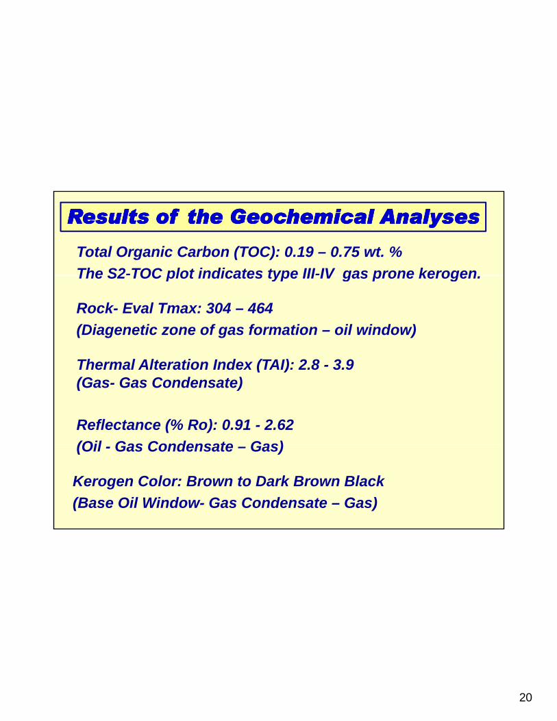
Results of the Geochemical AnalysesResults of the Geochemical Analyses
Total Organic Carbon (TOC): 0.19 – 0.75 wt. %The S2-TOC plot indicates type III-IV gas prone kerogen
Th l Alt ti I d (TAI) 2 8 3 9
Rock- Eval Tmax: 304 – 464(Diagenetic zone of gas formation – oil window)
The S2 TOC plot indicates type III IV gas prone kerogen.
Thermal Alteration Index (TAI): 2.8 - 3.9 (Gas- Gas Condensate)
Reflectance (% Ro): 0.91 - 2.62(Oil Gas Condensate Gas)(Oil - Gas Condensate – Gas)
Kerogen Color: Brown to Dark Brown Black(Base Oil Window- Gas Condensate – Gas)
21
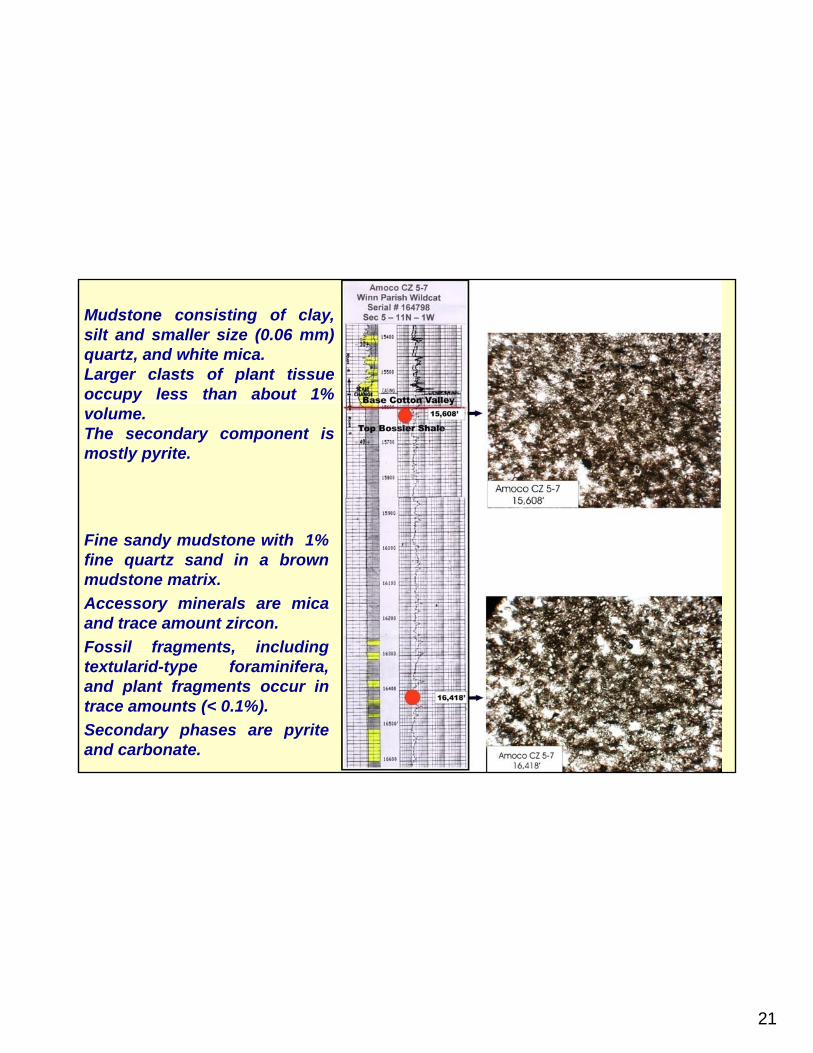
Mudstone consisting of clay,silt and smaller size (0.06 mm)quartz, and white mica.Larger clasts of plant tissueoccupy less than about 1%pyvolume.The secondary component ismostly pyrite.
Fine sandy mudstone with 1%fine quartz sand in a brownmudstone matrix.Accessory minerals are micaand trace amount zircon.Fossil fragments includingFossil fragments, includingtextularid-type foraminifera,and plant fragments occur intrace amounts (< 0.1%).Secondary phases are pyriteand carbonate.
22
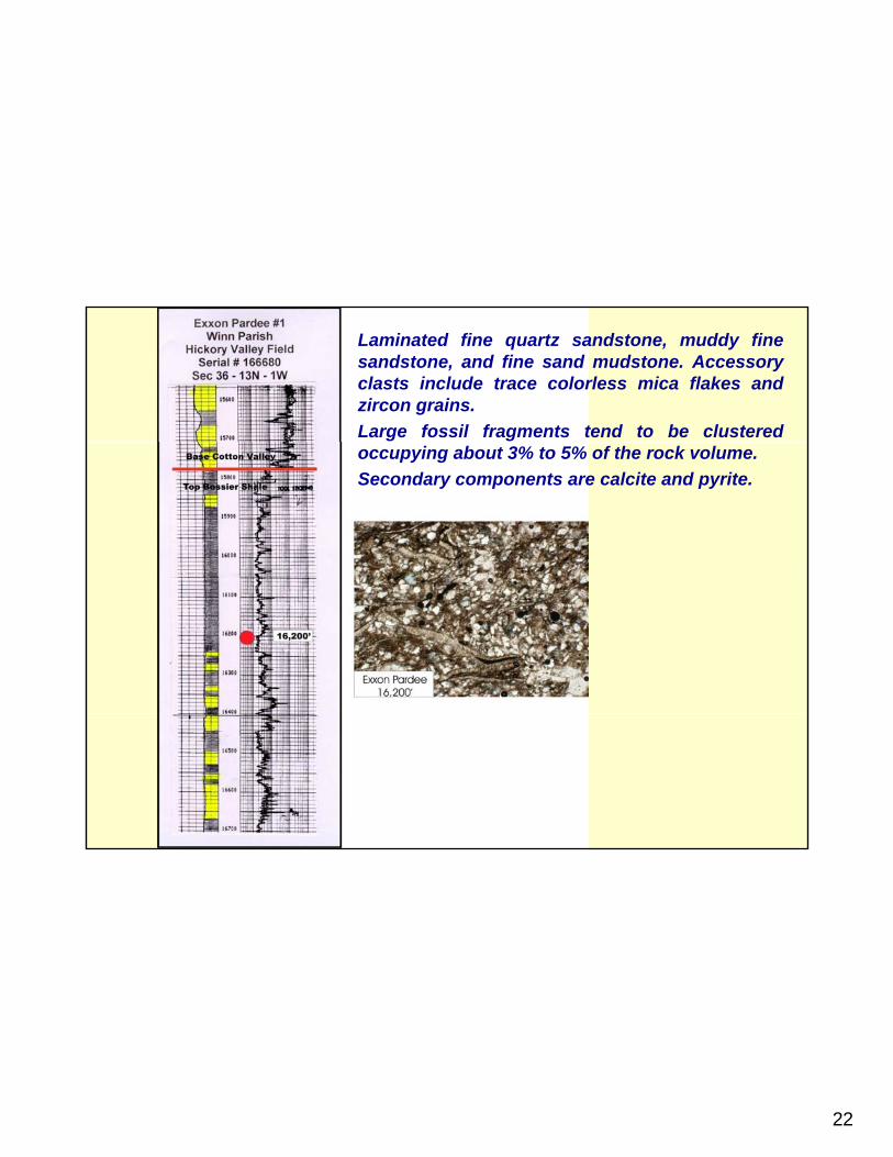
Laminated fine quartz sandstone, muddy finesandstone, and fine sand mudstone. Accessoryclasts include trace colorless mica flakes andzircon grains.Large fossil fragments tend to be clusteredoccupying about 3% to 5% of the rock volume.Secondary components are calcite and pyrite.

23
•Calcareous black shale, dark brown in thinsection. Silt and very fine sand size quartzsupported by matrix of dark brown claydominated mud.
•Fossil shell fragments occupy about 2% byvolume and include tests of bivalves andforaminifera.
Secondary components are calcite and pyrite•Secondary components are calcite and pyrite.

24
•Black shale with fine sand, dark brown,mostly fine mud with <1% silt size (0.05 mm)
t d t d b dd fi dquartz, and supported by muddy fine sandconsisting of quartz with interstitial clay-richmud.
•Approximately 10% of the volume isoccupied by filaments of organic tissueoccupied by filaments of organic tissue.
•The secondary component is primarily pyrite

25
NATURALLY NATURALLY NATURALLY NATURALLY FRACTURED FRACTURED
SHALE RESERVOIRSSHALE RESERVOIRS

26
Natural FracturesNatural Fractures

27

28
Shale Gas MapUSA SHALE GAS MAP
from Hart Energy Publishing

29

30
Haynesville
Source: US Energy Information Administration (EIA)

31
COMPARISON OF SOME SHALE GAS PLAYSCOMPARISON OF SOME SHALE GAS PLAYS

32
BOSSIER –HAYNESVILLE SHALE INTEREST IN NORTH LOUISIANA
Gas in Place 250 – 320 TCF
Recoverable Gas
Players:Chesapeake
Recoverable Gas 34 TCF (RF :15% to 30%)
pEncanaShellPetrohawk Plains Goodrich
Bossier-HaynesvilleDrilling Activity
EXCODevon

33
BASIC CONCEPTS
(Saturation) Hydrocarbon reservoirs are typically saturated with oil and/or gas and
Porosity (%) Reservoirs need to have pore space for storing oil and/or gas.
typically saturated with oil and/or gas and water (oil/gas > 70% & water < 30%).
Permeability (md) Reservoirs must be permeable to allow the fluids to flow through them.
Naturally fractured reservoirs (sandstone, limestone, shale) have very low porosity (< 7 %) & very low permeability (< 0.5 md).
34
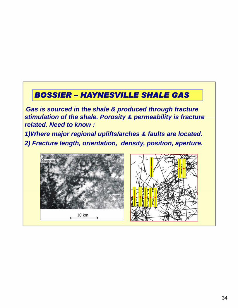
•Gas is sourced in the shale & produced through fracture stimulation of the shale Porosity & permeability is fracture
BOSSIER – HAYNESVILLE SHALE GAS
stimulation of the shale. Porosity & permeability is fracture related. Need to know :1)Where major regional uplifts/arches & faults are located. 2) Fracture length, orientation, density, position, aperture.

35
BOSSIER-HAYNESVILLE RESERVOIR PARAMETERS: Net pay thickness (ft): 100 - 200Porosity average (%): 7 - 12Permeability average (md): 0 015 - 0 043Permeability average (md): 0.015 - 0.043Water saturation average (%): 25 - 30Temperature 250° to 300° F.Reservoir pressure (psi): 8,000 - 10,000Requires hydraulic fracture stimulation Requires hydraulic fracture stimulation Pre-stimulation (Mcf/d): 500 - 1000Post-stimulation (MMcf/d): 10 - 25Expected recovery per completion (BCF): 4.0 - 7.0 D li t 50% 80% i fi t Decline rate: 50% - 80% in first year

36
HOW ABOUT HOW ABOUT A FEW
“WHAT Ifs”

37
•GR/DLL
•Neutron Density
•Sonic
•Magnetic Resonance
•MDT (Modular FormationFormationDynamic Tester)
•Borehole Imaging Tool
38
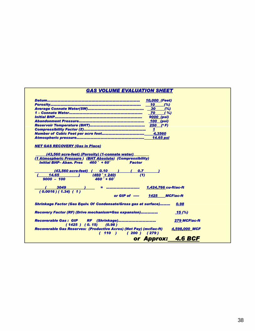
GAS VOLUME EVALUATION SHEET
Datum……………………………………………………………………… 10,000 (Feet)Porosity……………………………………………………………………. 10 (%)Average Connate Water(SW)…………………………………………. 30 (%)1 – Connate Water………………………………………………………. 70 ( %) Initial BHP…………………………………………………………………. 9000 (psi)Abandonment Pressure………………………………………………… 100 (psi)Reservoir Temperature (BHT)………………………………………… 250 (o F)p ( ) ( )Compressibility Factor (Z)……………………………………………… 1Number of Cubic Feet per acre foot………………………………. 4,3560Atmospheric pressure………………………………………………….. 14.65 psi
NET GAS RECOVERY (Gas in Place)
(43,560 acre-feet) (Porosity) (1-connate water)_________ (1 Atmospheric Pressure ) (BHT Absolute) (Compressibility)
Initial BHP– Aban. Pres 460 ˚ + 60˚ Factor
(43,560 acre-feet) ( 0.10 ) ( 0.7 ) ( 14.65 ) (460 ˚ + 240) (1)
9000 – 100 460 ˚ + 60˚
( 3049 ) = ……………………….. 1,424,766 cu-ft/ac-ft( 0.0016 ) ( 1.34) ( 1 )
or GIP of 1425 MCF/ac-ft
Shrinkage Factor (Gas Equiv Of Condensate/Gross gas at surface) 0 98Shrinkage Factor (Gas Equiv. Of Condensate/Gross gas at surface)……… 0.98
Recovery Factor (RF) (Drive mechanism=Gas expansion)…………… 15 (%)
Recoverable Gas : GIP RF (Shrinkage)…………………………… 279 MCF/ac-ft( 1425 ) ( 0. 15) (0.98 )
Recoverable Gas Reserves: (Productive Acres) (Net Pay) (mcf/ac-ft) 4,598,000 MCF ( 110 ) ( 200 ) ( 279 )
or Approx: 4.6 BCF

39
EXPLORATION & PRODUCTION
EXPLORATION METHODSf
OPTIMUM PRODUCTION METHOD
3D seismic technology for locating major structures such as anticlines or faults that are responsible for the fracturing ($85,000/sq.mile).
OPTIMUM PRODUCTION METHODDrill horizontal wells in order to cut maximum amount of fractures ($5 - $8 million/well)
Perform hydraulic fractures to increase permeability($600,000 - $900,000/well).

40

41
3D Seismic Line: Woodford Shale Play, Oklahoma
Modified After Miller & Young, AAPG, 2007

42
Northwest Louisiana Structural Systems

43
Horizontal Drilling Horizontal Drilling
After Rick Stone (Signa), 2008
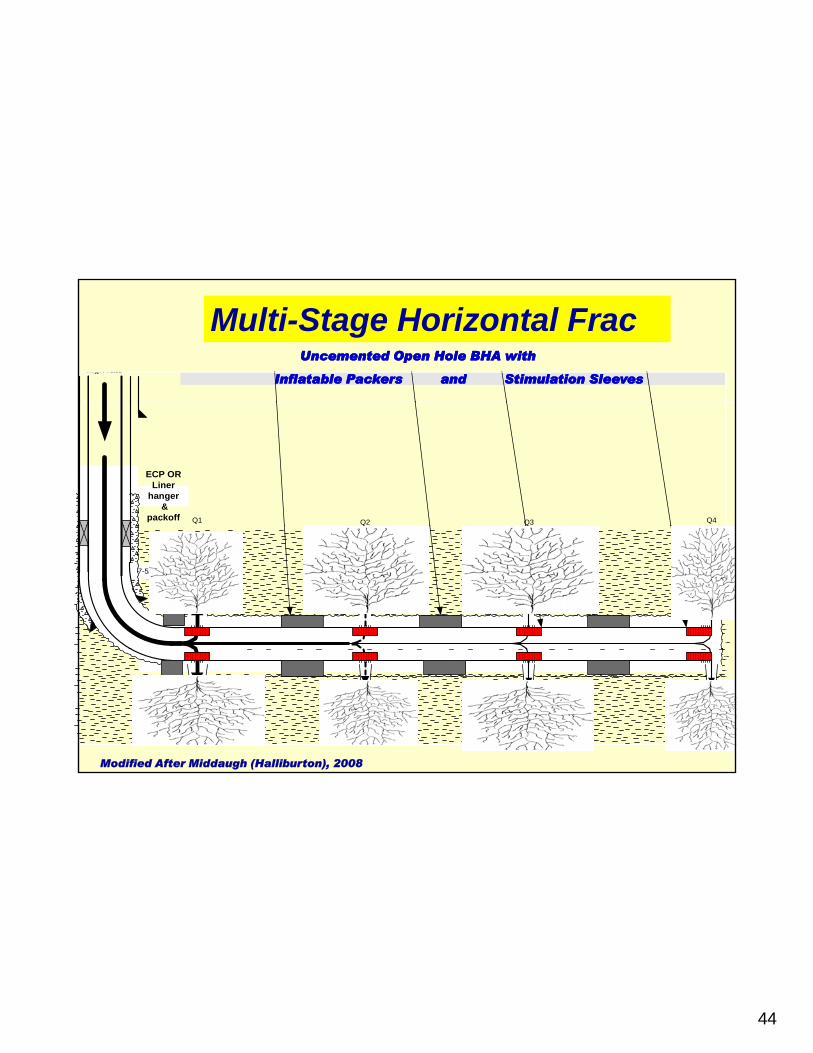
44
high rateUncementedUncemented Open Hole BHA with Open Hole BHA with
Inflatable Packers and Stimulation SleevesInflatable Packers and Stimulation Sleeves
Multi-Stage Horizontal Frac
ECP ORLiner
hanger &
packoff Q2Q1 Q3 Q4
7-5/8" -9 5/8"CSG
Modified After Middaugh (Halliburton), 2008

45
Hydraulic FractureFractureOperation
46
CONCLUSIONSResults of the Geochemical Analyses Results of the Geochemical Analyses (Rock(Rock--EvalEval, TOC & Visual , TOC & Visual kerogenkerogen) analyses) ) analyses) indicate that the Cotton Valleyindicate that the Cotton Valley--Bossier Group & Bossier Group & Haynesville fineHaynesville fine--grained rocks contain mostly gasgrained rocks contain mostly gas--prone type III prone type III kerogenkerogen and have very good oil & gas generative potential.and have very good oil & gas generative potential.
Th Th thi k d id d d itithi k d id d d iti f th B if th B i H illH illThe The thickness and widespread depositionthickness and widespread deposition of the Bossierof the Bossier--HaynesvilleHaynesvillestrata allows it to be an excellent source rock responsible for some ofstrata allows it to be an excellent source rock responsible for some ofthe oil & gas accumulations in the overlying Cotton Valley the oil & gas accumulations in the overlying Cotton Valley HosstonHosston and and SligoSligo reservoirs. reservoirs.
The BossierThe Bossier--Haynesville interval in north Louisiana is also considered Haynesville interval in north Louisiana is also considered yya potential shale gas reservoir with large reserves.a potential shale gas reservoir with large reserves.
Such shale gas reservoirs can be economicallySuch shale gas reservoirs can be economicallyattractive for the following reasons:attractive for the following reasons:1) The reserves are large. 1) The reserves are large. 2) There’s a demand for gas.2) There’s a demand for gas.3) The high price of gas ($6 3) The high price of gas ($6 -- $12 per $12 per mcfmcf).).4) The availability of technologies to drill and4) The availability of technologies to drill and
produce them.produce them.