Cass County, ND Land for Rent / Farmstead for … for due by Friday, September 25, 2015 Cass County,...
12
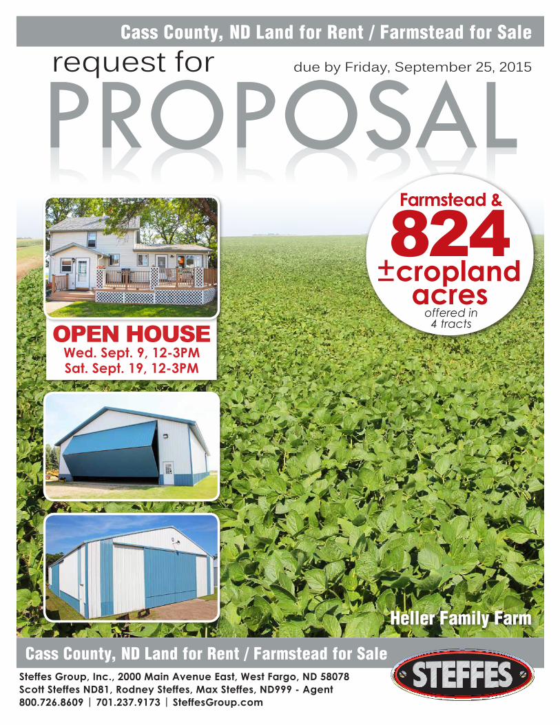
PROPOSAL request for due by Friday, September 25, 2015 Cass County, ND Land for Rent / Farmstead for Sale Cass County, ND Land for Rent / Farmstead for Sale Steffes Group, Inc., 2000 Main Avenue East, West Fargo, ND 58078 Scott Steffes ND81, Rodney Steffes, Max Steffes, ND999 - Agent 800.726.8609 | 701.237.9173 | SteffesGroup.com Heller Family Farm OPEN HOUSE Wed. Sept. 9, 12-3PM Sat. Sept. 19, 12-3PM 824 acres cropland Farmstead & offered in 4 tracts
Transcript of Cass County, ND Land for Rent / Farmstead for … for due by Friday, September 25, 2015 Cass County,...

PROPOSALrequest for due by Friday, September 25, 2015
Cass County, ND Land for Rent / Farmstead for Sale
Cass County, ND Land for Rent / Farmstead for Sale
Steffes Group, Inc., 2000 Main Avenue East, West Fargo, ND 58078Scott Steffes ND81, Rodney Steffes, Max Steffes, ND999 - Agent800.726.8609 | 701.237.9173 | SteffesGroup.com
Heller Family Farm
OPEN HOUSEWed. Sept. 9, 12-3PMSat. Sept. 19, 12-3PM
824acres
cropland
Farmstead &
offered in4 tracts

2
824+/- Cropland AcresLENGTH OF AGREEMENT: 2016,
2017, & 2018 Crop Years (3 years)18.94+/- acre Farmstead located:
1580 167th Ave SE, Gardner, ND 58036Offered in four separate farms, together,
or in any combination. As part of your proposals, offers to purchase the farmstead described below are also requested and will be entertained.
This is a wonderful opportunity to expand your operation and to acquire a farmstead complete with housing, grain storage, and ample machinery storage.
CROPLAND PAYMENTS: Due on March 1st of 2016, 2017, and 2018. Proposal should be submitted based on a per acre basis. Final determination of actual FSA Cropland Acres will be determined at contract signing and may be adjusted as acres are identified.
FARMSTEAD BIDDING TERMS& REQUIREMENTS:• Those interested in submitting a bid
on the Farmstead are required to fill out a Bid Form which are available upon request and for download on our website.
• All bids must be received by 5:00 P.M. Friday, September 25th, 2015.
• Notification will be given to the successful bidder once evaluations have been completed on or before 5:00 P.M., Friday, October 2nd, 2015.
• The successful bidder will be required to sign a purchase agreement.
• Closing will be on or before 45 days from signing of Purchase Agreement.
• 10% of the total purchase price will be payable as earnest money upon signing of Purchase Agreement with the remaining balance due at closing.
• This property is being offered AS IS with no warranties expressed or implied.
• This property is offered for sale to qualified purchasers without regard to sex, race, color, religion, natural origin, or handicap.
• The owner(s) reserve the right to accept or reject any and all bids.
• Interested parties should submit their highest and best bid.
ADDITIONAL TERMS:• Notification and award of the farm(s)
and farmstead will be given once evaluations have been completed on or before 5:00PM, Friday, October 2nd, 2015. Contract signing will take place at the Steffes Group office in West Fargo.
• Only offers to purchase the Farmstead should be submitted. Offers to rent the Farmstead will not be considered.
CONSIDERATIONS:• While price is a significant factor, it will
not be the only criteria to award the final rental agreement.
• Stewardship of the land, excellent farming practices, quality equipment, capacity and resources will all be factors.
• Interested parties must present a comprehensive proposal in a professional manner that proves and
demonstrates these abilities. The proposals might include timelines of farm histories, inventories of equipment available, projected crop rotations, letters of recommendations from other landlords/vendors or lenders.
• Demonstration or proof of financial stability/position will also be considered.
• All positive criteria will be evaluated so any pertinent data, pictures, history and qualifications will be helpful.
• Be professional, comprehensive and detailed in your packages.
• The proposals must be in the form of a written document. An oral presentation will not be considered.
• All four farms and the farmstead are offered separately, together, or in any combinations.
• Each proposal submitted may include multiple entities. Creative options may be presented; however, it should be submitted as an “option” with any pertinent details for considerations, and separate from your primary proposal.
For details please contact Max Steffes at 701.237.9173.All proposals & bids must be received no later than 5:00 PM on Friday, September 25, 2015.Deliver to: Steffes Group, Inc. 2000 Main Avenue East West Fargo, ND 58078 or Email to: Max Steffes, [email protected]
The Heller family is seeking proposals to enter into a Tenant/Landlord relationship for the below described
farmland located in Gardner & Kinyon Townships of Cass County, ND. In addition, the 18.94+/- acre
farmstead is also being offered for sale.
REQUEST for Proposal Criteria
310.83+/- Cropland Acres Kinyon Township W1/2 Section 13-143-50 Productivity Index: 84.7
276.63+/- Cropland AcresKinyon Township S1/2 Section 23-143-50 Less 18.94AC Farmstead & R/W Productivity Index: 84
155.64+/- Cropland Acres Gardner Township NW1/4 Section 10-142-50 Productivity Index: 87
81.19 Cropland AcresGardner Township S1/2 of NW1/4 Section 21-142-50 Productivity Index: 92
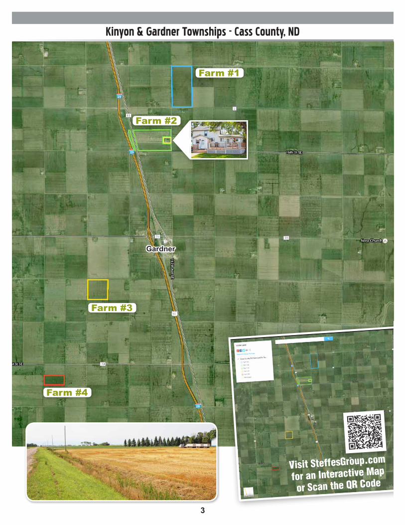
Farm #1
Farm #4
Farm #3
Farm #2
3
Kinyon & Gardner Townships - Cass County, ND
Farm #1
Farm #2
Farm #4
Visit SteffesGroup.com
for an Interactive Map
or Scan the QR Code
Farm #3
Gardner

4
Farmstead & Property Details
FarmsteadDirections to Farmstead: From I-29 exit 86 near
Gardner, ND: 1/2 mile E on Cty. Rd 26 to 167th Ave SE then N 2 1/4 miles. Farmstead located on left (West) hand side of road
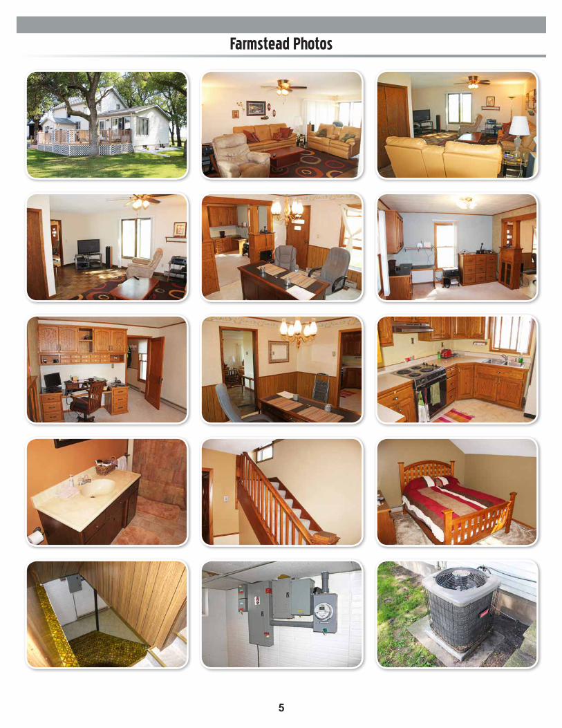
Property Note: Enjoy rural living on this large farmstead located approximately 20 miles from the Fargo-Moorhead Metro. This property would make a great rural residence/farm HQ. The 2-story house located on the property features 3BD & 2BR + 3 additional rooms in the basement that couldbe converted to bedrooms. There are several outbuildings including a large 105’ x 60’ Foltz buildingthat could be repurposed for horses/business useor rented out for income. The 7+/- acres of croplandcould be used for additional rental income or farmedas a large garden/hobby farm
Property Details: • 1580 167th Ave SE Gardner, ND 58036• 18.94+/- Acres• 7.50+/- Cropland Acres• 105’ x 60’ Foltz Building
• Built in 2007• 17’ x 40’ bi-fold door• 45’ x 10’ front concrete apron• 14’ x 14’ overhead side door• 14’ x 10’ side concrete apron• 125 Amp service• Dirt floors
• 1,750 sq. ft., 3BD, 2B, 2-Story Home• Built in 1928• Addition in 1977• Steel siding• Concrete block foundation
• July 2014- $24,028 spent on recent repairs that included partial wall replacement on north and west walls, installation of waterproofing membrane, and installation of drain tile. Work orders available to download on our website or upon request.
• Westward facing maintenance free deck• 3 additional potential bedrooms in basement• Electric baseboard heat• Fuel oil furnace backup heat• Central air• (2) Septic systems• Rural water• All appliances including washer/dryerand newer window AC unit included.
• 24’ x 24’ Double Detached Garage• Steel siding• Concrete floor• 6’ x 15’ insulated garage door
• 36’ x 36’ Shop• 14’ x 24’ overhead door• Aaladin Eliminator waste oil heater• Insulated• Electric floor heat• Pole frame• Includes air compressor
• 90’ x 54’ Morton Building• 16’ x 23 ½ front sliding door• 15’ x 26 ½ side sliding door• Pole frame• Gravel floor
• 60’ x 36’ Machine Shed• 12’ x 18’ overhead door• 100 Amp service• Pole frame• Gravel floor
• 56,700+/- Bu. of Grain Storage• (1) 10,000 Bu. Bin• (3) 7,000 Bu. Bin• (1) 5,500 Bu. Bin• (4) 2,800 Bu. Bin• (3) 3,000 Bu. Bin
• (2) Older Buildings• 25’ x 16’ & 16’ x 14’
• Taxes (2014): $278.28• PID# 49-0000-07903-020• Please note: discounted amount based onTax Exemption for Farm Residence.Subject to reassessment under new owner.
5
Farmstead Photos
6
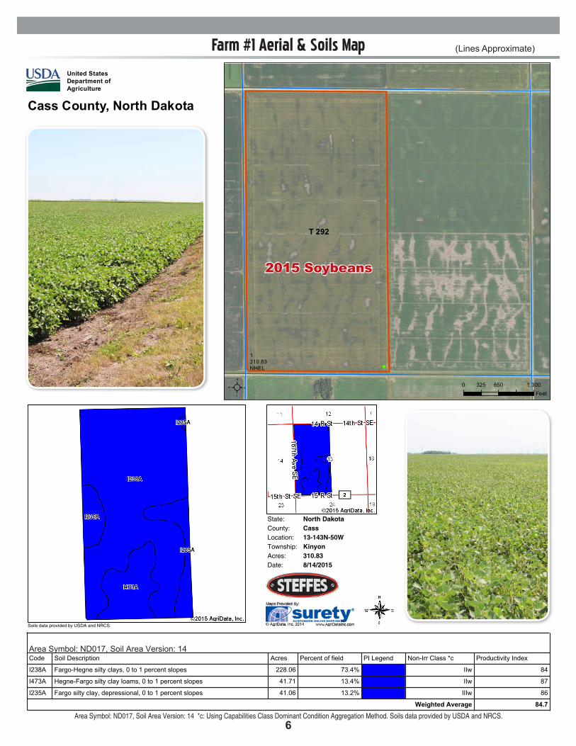
Farm #1 Aerial & Soils Map (Lines Approximate)
State: North DakotaCassCounty:13-143N-50WLocation:
Township: KinyonAcres: 310.83Date: 8/14/2015
Soils data provided by USDA and NRCS.
Soil Map
Area Symbol: ND017, Soil Area Version: 14Code Soil Description Acres Percent of field PI Legend NonIrr Class *c Productivity Index
I238A FargoHegne silty clays, 0 to 1 percent slopes 228.06 73.4% IIw 84
I473A HegneFargo silty clay loams, 0 to 1 percent slopes 41.71 13.4% IIw 87
I235A Fargo silty clay, depressional, 0 to 1 percent slopes 41.06 13.2% IIIw 86
Weighted Average 84.7
Area Symbol: ND017, Soil Area Version: 14
*c: Using Capabilities Class Dominant Condition Aggregation Method
Soils data provided by USDA and NRCS.
State: North DakotaCassCounty:13-143N-50WLocation:
Township: KinyonAcres: 310.83Date: 8/14/2015
Soils data provided by USDA and NRCS.
Soil Map
Area Symbol: ND017, Soil Area Version: 14Code Soil Description Acres Percent of field PI Legend NonIrr Class *c Productivity Index
I238A FargoHegne silty clays, 0 to 1 percent slopes 228.06 73.4% IIw 84
I473A HegneFargo silty clay loams, 0 to 1 percent slopes 41.71 13.4% IIw 87
I235A Fargo silty clay, depressional, 0 to 1 percent slopes 41.06 13.2% IIIw 86
Weighted Average 84.7
Area Symbol: ND017, Soil Area Version: 14
*c: Using Capabilities Class Dominant Condition Aggregation Method
Soils data provided by USDA and NRCS. Area Symbol: ND017, Soil Area Version: 14 *c: Using Capabilities Class Dominant Condition Aggregation Method. Soils data provided by USDA and NRCS.
")
1310.83NHEL
T 292
United StatesDepartment ofAgriculture
Farm 9802
²2015 Program Year
Cass County, North Dakota
S13 T143N R50W
Map Created November 25, 2014
0 650 1,300325Feet
United States Department of Agriculture (USDA) Farm Service Agency (FSA) maps are for FSA Program administration only. This map does not represent a legal survey or reflect actualownership; rather it depicts the information provided directly from the producer and/or National Agricultural Imagery Program (NAIP) imagery. The producer accepts the data 'as is' and assumes all risks associated with its use. USDA-FSA assumes no responsibility for actual or consequential damage incurred as a result of any user's reliance on this data outside FSA Programs. Wetland identifiers do not represent the size, shape, or specific determination of the area. Refer to your original determination (CPA-026 and attached maps) for exactboundaries and determinations or contact USDA Natural Resources Conservation Service (NRCS).
Wetland Determination Identifiers&- Restricted Use#*
Limited Restrictions
")Exempt from ConservationCompliance Provisions
Common Land UnitCroplandTract Boundary
PLSS
2015 Soybeans

7
Farm #2 Aerial & Soils Map (Lines Approximate)
State: North DakotaCassCounty:23-143N-50WLocation:
Township: KinyonAcres: 276.64Date: 8/14/2015
Soils data provided by USDA and NRCS.
Soil Map
Area Symbol: ND017, Soil Area Version: 14Code Soil Description Acres Percent of field PI Legend NonIrr Class *c Productivity Index
I238A FargoHegne silty clays, 0 to 1 percent slopes 261.49 94.5% IIw 84
I229A Fargo silty clay, 0 to 1 percent slopes 10.61 3.8% IIw 86
I235A Fargo silty clay, depressional, 0 to 1 percent slopes 4.32 1.6% IIIw 86
I906F OrthentsAquentsUrban Land, highway complex, 0 to 35 percent slopes 0.22 0.1% IVe 32
Weighted Average 84.1
Area Symbol: ND017, Soil Area Version: 14
*c: Using Capabilities Class Dominant Condition Aggregation Method
Soils data provided by USDA and NRCS.
State: North DakotaCassCounty:23-143N-50WLocation:
Township: KinyonAcres: 276.64Date: 8/14/2015
Soils data provided by USDA and NRCS.
Soil Map
Area Symbol: ND017, Soil Area Version: 14Code Soil Description Acres Percent of field PI Legend NonIrr Class *c Productivity Index
I238A FargoHegne silty clays, 0 to 1 percent slopes 261.49 94.5% IIw 84
I229A Fargo silty clay, 0 to 1 percent slopes 10.61 3.8% IIw 86
I235A Fargo silty clay, depressional, 0 to 1 percent slopes 4.32 1.6% IIIw 86
I906F OrthentsAquentsUrban Land, highway complex, 0 to 35 percent slopes 0.22 0.1% IVe 32
Weighted Average 84.1
Area Symbol: ND017, Soil Area Version: 14
*c: Using Capabilities Class Dominant Condition Aggregation Method
Soils data provided by USDA and NRCS. Area Symbol: ND017, Soil Area Version: 14 *c: Using Capabilities Class Dominant Condition Aggregation Method. Soils data provided by USDA and NRCS.
")
")
3 5.91
410.86
122.95
NH
EL
1310.83NHEL
2261.07NHEL
T 292
T 521T 521
United StatesDepartment ofAgriculture
Farm 9802
²2015 Program Year
Cass County, North Dakota
S23 T143N R50W
Map Created November 25, 2014
0 625 1,250312.5Feet
United States Department of Agriculture (USDA) Farm Service Agency (FSA) maps are for FSA Program administration only. This map does not represent a legal survey or reflect actualownership; rather it depicts the information provided directly from the producer and/or National Agricultural Imagery Program (NAIP) imagery. The producer accepts the data 'as is' and assumes all risks associated with its use. USDA-FSA assumes no responsibility for actual or consequential damage incurred as a result of any user's reliance on this data outside FSA Programs. Wetland identifiers do not represent the size, shape, or specific determination of the area. Refer to your original determination (CPA-026 and attached maps) for exactboundaries and determinations or contact USDA Natural Resources Conservation Service (NRCS).
Wetland Determination Identifiers&- Restricted Use#*
Limited Restrictions
")Exempt from ConservationCompliance Provisions
Common Land UnitCroplandNon-Cropland
Tract BoundaryPLSS
")
1310.83NHEL
T 292
United StatesDepartment ofAgriculture
Farm 9802
²2015 Program Year
Cass County, North Dakota
S13 T143N R50W
Map Created November 25, 2014
0 650 1,300325Feet
United States Department of Agriculture (USDA) Farm Service Agency (FSA) maps are for FSA Program administration only. This map does not represent a legal survey or reflect actualownership; rather it depicts the information provided directly from the producer and/or National Agricultural Imagery Program (NAIP) imagery. The producer accepts the data 'as is' and assumes all risks associated with its use. USDA-FSA assumes no responsibility for actual or consequential damage incurred as a result of any user's reliance on this data outside FSA Programs. Wetland identifiers do not represent the size, shape, or specific determination of the area. Refer to your original determination (CPA-026 and attached maps) for exactboundaries and determinations or contact USDA Natural Resources Conservation Service (NRCS).
Wetland Determination Identifiers&- Restricted Use#*
Limited Restrictions
")Exempt from ConservationCompliance Provisions
Common Land UnitCroplandTract Boundary
PLSS
2015 Wheat
2015 Soybeans
8
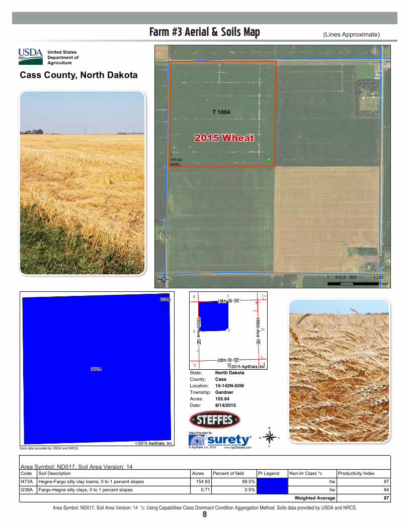
Farm #3 Aerial & Soils Map (Lines Approximate)
State: North DakotaCassCounty:10-142N-50WLocation:
Township: GardnerAcres: 155.64Date: 8/14/2015
Soils data provided by USDA and NRCS.
Soil Map
Area Symbol: ND017, Soil Area Version: 14Code Soil Description Acres Percent of field PI Legend NonIrr Class *c Productivity Index
I473A HegneFargo silty clay loams, 0 to 1 percent slopes 154.93 99.5% IIw 87
I238A FargoHegne silty clays, 0 to 1 percent slopes 0.71 0.5% IIw 84
Weighted Average 87
Area Symbol: ND017, Soil Area Version: 14
*c: Using Capabilities Class Dominant Condition Aggregation Method
Soils data provided by USDA and NRCS.
State: North DakotaCassCounty:10-142N-50WLocation:
Township: GardnerAcres: 155.64Date: 8/14/2015
Soils data provided by USDA and NRCS.
Soil Map
Area Symbol: ND017, Soil Area Version: 14Code Soil Description Acres Percent of field PI Legend NonIrr Class *c Productivity Index
I473A HegneFargo silty clay loams, 0 to 1 percent slopes 154.93 99.5% IIw 87
I238A FargoHegne silty clays, 0 to 1 percent slopes 0.71 0.5% IIw 84
Weighted Average 87
Area Symbol: ND017, Soil Area Version: 14
*c: Using Capabilities Class Dominant Condition Aggregation Method
Soils data provided by USDA and NRCS. Area Symbol: ND017, Soil Area Version: 14 *c: Using Capabilities Class Dominant Condition Aggregation Method. Soils data provided by USDA and NRCS.
")
1155.64NHEL
T 1004
United StatesDepartment ofAgriculture
Farm 9802
²2015 Program Year
Cass County, North Dakota
S10 T142N R50W
Map Created November 25, 2014
0 625 1,250312.5Feet
United States Department of Agriculture (USDA) Farm Service Agency (FSA) maps are for FSA Program administration only. This map does not represent a legal survey or reflect actualownership; rather it depicts the information provided directly from the producer and/or National Agricultural Imagery Program (NAIP) imagery. The producer accepts the data 'as is' and assumes all risks associated with its use. USDA-FSA assumes no responsibility for actual or consequential damage incurred as a result of any user's reliance on this data outside FSA Programs. Wetland identifiers do not represent the size, shape, or specific determination of the area. Refer to your original determination (CPA-026 and attached maps) for exactboundaries and determinations or contact USDA Natural Resources Conservation Service (NRCS).
Wetland Determination Identifiers&- Restricted Use#*
Limited Restrictions
")Exempt from ConservationCompliance Provisions
Common Land UnitCroplandTract Boundary
PLSS
")
1310.83NHEL
T 292
United StatesDepartment ofAgriculture
Farm 9802
²2015 Program Year
Cass County, North Dakota
S13 T143N R50W
Map Created November 25, 2014
0 650 1,300325Feet
United States Department of Agriculture (USDA) Farm Service Agency (FSA) maps are for FSA Program administration only. This map does not represent a legal survey or reflect actualownership; rather it depicts the information provided directly from the producer and/or National Agricultural Imagery Program (NAIP) imagery. The producer accepts the data 'as is' and assumes all risks associated with its use. USDA-FSA assumes no responsibility for actual or consequential damage incurred as a result of any user's reliance on this data outside FSA Programs. Wetland identifiers do not represent the size, shape, or specific determination of the area. Refer to your original determination (CPA-026 and attached maps) for exactboundaries and determinations or contact USDA Natural Resources Conservation Service (NRCS).
Wetland Determination Identifiers&- Restricted Use#*
Limited Restrictions
")Exempt from ConservationCompliance Provisions
Common Land UnitCroplandTract Boundary
PLSS
2015 Wheat
9
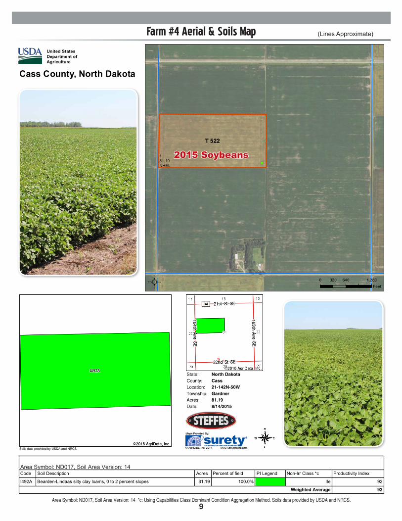
Farm #4 Aerial & Soils Map (Lines Approximate)
State: North DakotaCassCounty:21-142N-50WLocation:
Township: GardnerAcres: 81.19Date: 8/14/2015
Soils data provided by USDA and NRCS.
Soil Map
Area Symbol: ND017, Soil Area Version: 14Code Soil Description Acres Percent of field PI Legend NonIrr Class *c Productivity Index
I492A BeardenLindaas silty clay loams, 0 to 2 percent slopes 81.19 100.0% IIe 92
Weighted Average 92
Area Symbol: ND017, Soil Area Version: 14
*c: Using Capabilities Class Dominant Condition Aggregation Method
Soils data provided by USDA and NRCS.
State: North DakotaCassCounty:21-142N-50WLocation:
Township: GardnerAcres: 81.19Date: 8/14/2015
Soils data provided by USDA and NRCS.
Soil Map
Area Symbol: ND017, Soil Area Version: 14Code Soil Description Acres Percent of field PI Legend NonIrr Class *c Productivity Index
I492A BeardenLindaas silty clay loams, 0 to 2 percent slopes 81.19 100.0% IIe 92
Weighted Average 92
Area Symbol: ND017, Soil Area Version: 14
*c: Using Capabilities Class Dominant Condition Aggregation Method
Soils data provided by USDA and NRCS. Area Symbol: ND017, Soil Area Version: 14 *c: Using Capabilities Class Dominant Condition Aggregation Method. Soils data provided by USDA and NRCS.
")
181.19NHEL
T 522
United StatesDepartment ofAgriculture
Farm 9802
²2015 Program Year
Cass County, North Dakota
S21 T142N R50W
Map Created November 25, 2014
0 640 1,280320Feet
United States Department of Agriculture (USDA) Farm Service Agency (FSA) maps are for FSA Program administration only. This map does not represent a legal survey or reflect actualownership; rather it depicts the information provided directly from the producer and/or National Agricultural Imagery Program (NAIP) imagery. The producer accepts the data 'as is' and assumes all risks associated with its use. USDA-FSA assumes no responsibility for actual or consequential damage incurred as a result of any user's reliance on this data outside FSA Programs. Wetland identifiers do not represent the size, shape, or specific determination of the area. Refer to your original determination (CPA-026 and attached maps) for exactboundaries and determinations or contact USDA Natural Resources Conservation Service (NRCS).
Wetland Determination Identifiers&- Restricted Use#*
Limited Restrictions
")Exempt from ConservationCompliance Provisions
Common Land UnitCroplandTract Boundary
PLSS
")
1310.83NHEL
T 292
United StatesDepartment ofAgriculture
Farm 9802
²2015 Program Year
Cass County, North Dakota
S13 T143N R50W
Map Created November 25, 2014
0 650 1,300325Feet
United States Department of Agriculture (USDA) Farm Service Agency (FSA) maps are for FSA Program administration only. This map does not represent a legal survey or reflect actualownership; rather it depicts the information provided directly from the producer and/or National Agricultural Imagery Program (NAIP) imagery. The producer accepts the data 'as is' and assumes all risks associated with its use. USDA-FSA assumes no responsibility for actual or consequential damage incurred as a result of any user's reliance on this data outside FSA Programs. Wetland identifiers do not represent the size, shape, or specific determination of the area. Refer to your original determination (CPA-026 and attached maps) for exactboundaries and determinations or contact USDA Natural Resources Conservation Service (NRCS).
Wetland Determination Identifiers&- Restricted Use#*
Limited Restrictions
")Exempt from ConservationCompliance Provisions
Common Land UnitCroplandTract Boundary
PLSS
2015 Soybeans
10
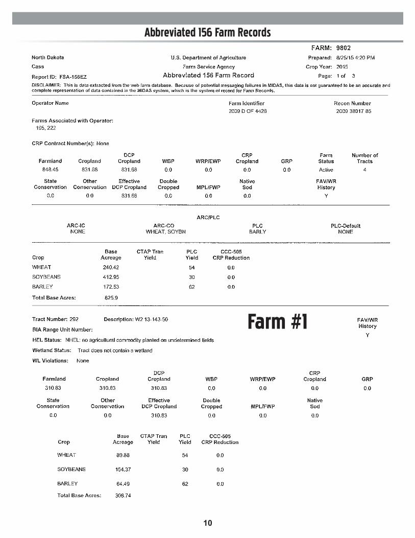
Abbreviated 156 Farm Records
Farm #1

11
Abbreviated 156 Farm Records
Farm #2
Farm #4
Please Note: Total cropland acres for Farm #2 are 276+/- acres. This 156 record includes cropland
acres included in the farmstead.
Farm #3
PROPOSALrequest for due by Friday, September 25, 2015
Cass County, ND Land for Rent / Farmstead for Sale
Cass County, ND Land for Rent / Farmstead for Sale
Steffes Group, Inc., 2000 Main Avenue East, West Fargo, ND 58078Scott Steffes ND81, Rodney Steffes, Max Steffes, ND999 - Agent800.726.8609 | 701.237.9173 | SteffesGroup.com
Heller Family Farm
OPEN HOUSEWed. Sept. 9, 12-3PMSat. Sept. 19, 12-3PM
824acres
cropland
Farmstead &
offered in4 tracts