Case Study : Munitions Dumping at Beaufort’s Dyke · BEAUFORT’S DYKE Case Study : Munitions...
2
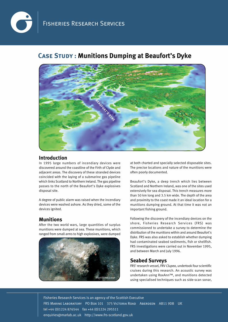
BEAUFORT’S DYKE Case Study : Munitions Dumping at Beaufort’s Dyke Introduction In 1995 large numbers of incendiary devices were discovered around the coastline of the Firth of Clyde and adjacent areas. The discovery of these stranded devices coincided with the laying of a submarine gas pipeline which links Scotland to Northern Ireland. The gas pipeline passes to the north of the Beaufort’s Dyke explosives disposal site. A degree of public alarm was raised when the incendiary devices were washed ashore. As they dried, some of the devices ignited. Munitions After the two world wars, large quantities of surplus munitions were dumped at sea. These munitions, which ranged from small arms to high explosives, were dumped Munitions case at both charted and specially selected disposable sites. The precise locations and nature of the munitions were often poorly documented. Beaufort’s Dyke, a deep trench which lies between Scotland and Northern Ireland, was one of the sites used extensively for sea disposal. This trench measures more than 50 km long and 3.5 km wide. The depth of the area and proximity to the coast made it an ideal location for a munitions dumping ground. At that time it was not an important fishing ground. Following the discovery of the incendiary devices on the shore, Fisheries Research Services (FRS) was commissioned to undertake a survey to determine the distribution of the munitions within and around Beaufort's Dyke. FRS was also asked to establish whether dumping had contaminated seabed sediments, fish or shellfish. FRS investigations were carried out in November 1995, and between March and July 1996. Seabed Surveys FRS’ research vessel, FRV Clupea, undertook four scientific cruises during this research. An acoustic survey was undertaken using RoxAnn™, and munitions detected using specialised techniques such as side-scan sonar,
Transcript of Case Study : Munitions Dumping at Beaufort’s Dyke · BEAUFORT’S DYKE Case Study : Munitions...
BEAUFORT’S DYKE
Case Study : Munitions Dumping at Beaufort’s Dyke
IntroductionIn 1995 large numbers of incendiary devices werediscovered around the coastline of the Firth of Clyde andadjacent areas. The discovery of these stranded devicescoincided with the laying of a submarine gas pipelinewhich links Scotland to Northern Ireland. The gas pipelinepasses to the north of the Beaufort’s Dyke explosivesdisposal site.
A degree of public alarm was raised when the incendiarydevices were washed ashore. As they dried, some of thedevices ignited.
MunitionsAfter the two world wars, large quantities of surplusmunitions were dumped at sea. These munitions, whichranged from small arms to high explosives, were dumped
Munitions case
at both charted and specially selected disposable sites.The precise locations and nature of the munitions wereoften poorly documented.
Beaufort’s Dyke, a deep trench which lies betweenScotland and Northern Ireland, was one of the sites usedextensively for sea disposal. This trench measures morethan 50 km long and 3.5 km wide. The depth of the areaand proximity to the coast made it an ideal location for amunitions dumping ground. At that time it was not animportant fishing ground.
Following the discovery of the incendiary devices on theshore, Fisheries Research Services (FRS) wascommissioned to undertake a survey to determine thedistribution of the munitions within and around Beaufort'sDyke. FRS was also asked to establish whether dumpinghad contaminated seabed sediments, fish or shellfish.FRS investigations were carried out in November 1995,and between March and July 1996.
Seabed SurveysFRS’ research vessel, FRV Clupea, undertook four scientificcruises during this research. An acoustic survey wasundertaken using RoxAnn™, and munitions detectedusing specialised techniques such as side-scan sonar,
Seabed ContaminationSamples of the seabed sediment were analysed. None ofthe samples contained the chemical warfare agentsphosgene or mustard gas, or explosive or propellantresidues. There was also no indication of phosphorus,which is a component of the incendiary devices. The levelsof trace metals were found to be within the ranges reportedfor other Scottish coastal areas, and similar to the levelsfound in the Irish Sea.
Marine Wildlife ContaminationFish and shellfish samples were analysed and were notfound to contain explosive or propellant residues. Thelevels of heavy metals were within the ranges reported incommercial catches from elsewhere in UK waters.
It was concluded that dumped munitions were locatedoutside the charted boundary of the disposal site, butthat dumping had not resulted in contamination of seabedsediments or of commercially exploited fish or shellfish.
Other UsesThe munitions distribution data have already provedinvaluable in the planning of the new routes for electricityand telephone cables crossing Beaufort’s Dyke.
pulse induction and magnetometry. These techniquespermitted detailed seabed imaging to determine the depthand nature of the seabed, and the distribution and densityof dumped munitions and seabed debris. Underwatertelevision cameras, used in conjunction with high qualitystill photography provided information on the nature ofthe munitions and the debris. In addition, FRS staffcollected and analysed samples of seabed sediment, fishand shellfish for signs of contamination.
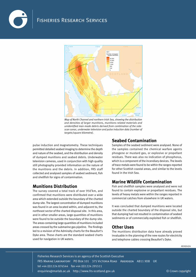
Munitions DistributionThe survey covered a total track of over 950 km, andconfirmed that munitions were distributed over a widearea which extended outside the boundary of the charteddump site. The largest concentration of dumped munitionswas found in an area located within, and adjacent to, thenortheast sector of the charted disposal site. In this area,and in other smaller areas, large quantities of munitionswere found to be outside the boundary of the dump site.The areas containing large quantities of munitions includedareas crossed by the submarine gas pipeline. The findingsled to a revision of the Admiralty charts for the Beaufort’sDyke area. These charts are the standard seabed chartsused for navigation in UK waters.
200 m
100 m
100 m
200 m
20 m
20 m
100 m
100 m
S C O T L A N D
4°30'W
ISLE OFMAN
54°30'N
5°00'W
5°00'W
55°00'N
5°30'W
4°30'W
30,000
10,000
3,000
1,000
300
100
0
Number of targets/square kilometre
KEY:
Map of North Channel and northern Irish Sea, showing the distributionand densities of larger munitions, munitions-related materials andunidentified man-made debris derived from combination of the side-scan sonar, underwater television and pulse induction data (number oftargets/square kilometre).
Fisheries Research Services is an agency of the Scottish Executive
FRS Marine Laboratory PO Box 101 375 Victoria Road Aberdeen AB11 9DB UK
tel +44 (0)1224 876544 fax +44 (0)1224 295511
[email protected] http://www.frs-scotland.gov.uk © Crown copyright
AE08|04|04