Carla C. Sullivan NOAA Senior Policy Advisor Office of the Under Secretary of Commerce for Oceans...
20
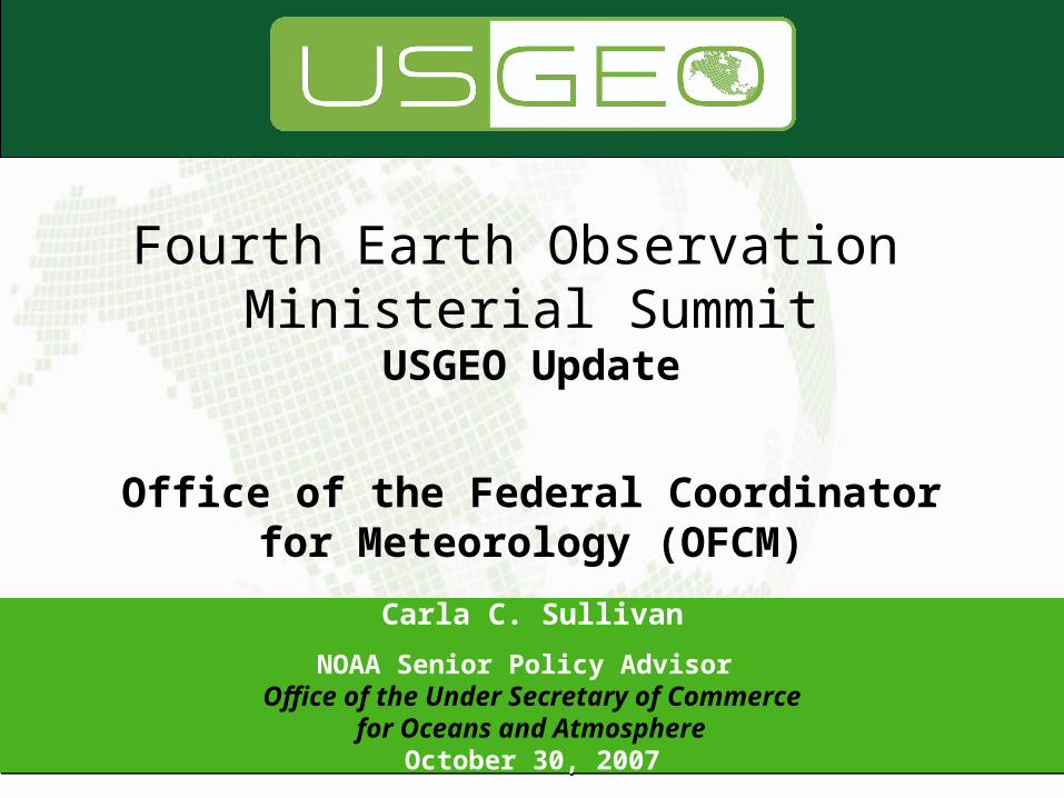
Carla C. Sullivan NOAA Senior Policy Advisor Office of the Under Secretary of Commerce for Oceans and Atmosphere October 30, 2007 Fourth Earth Observation Ministerial Summit USGEO Update Office of the Federal Coordinator for Meteorology (OFCM)
-
Upload
anissa-parrish -
Category
Documents
-
view
215 -
download
0
Transcript of Carla C. Sullivan NOAA Senior Policy Advisor Office of the Under Secretary of Commerce for Oceans...
Carla C. Sullivan
NOAA Senior Policy Advisor Office of the Under Secretary of Commerce
for Oceans and Atmosphere October 30, 2007
Carla C. Sullivan
NOAA Senior Policy Advisor Office of the Under Secretary of Commerce
for Oceans and Atmosphere October 30, 2007
Fourth Earth Observation Ministerial Summit
USGEO Update
Office of the Federal Coordinator for Meteorology (OFCM)

2
“President Bush and Prime Minister Abe agreed today that confronting the interlinked challenges of energy security, clean development, and climate change requires sustained and effective global action. The United States and Japan . . . will continue to exercise leadership in the development of the Global Earth Observation System of Systems (GEOSS).”
U.S. - Japan Joint Statement on
Energy Security, Clean Development,
and Climate Change, April 27, 2007
U.S. Commitment to GEOSS U.S. Commitment to GEOSS

3
Earth Observation ImperativeEarth Observation Imperative
Understanding the Earth system is fundamental for well informed economic decision making
A global sustained approach to Earth observation is required
The U.S. benefits from the Global Earth Observation System of System
GEOSS
4
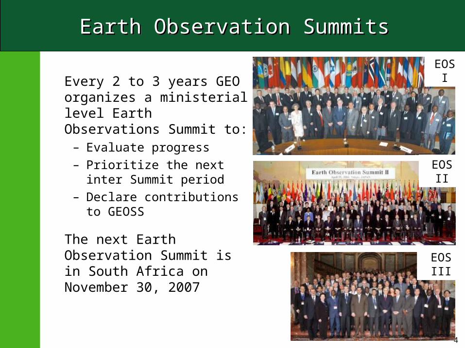
Earth Observation SummitsEarth Observation Summits
Every 2 to 3 years GEO organizes a ministerial level Earth Observations Summit to:
– Evaluate progress– Prioritize the next inter
Summit period– Declare contributions to
GEOSS
The next Earth Observation Summit is in South Africa on November 30, 2007
EOS I
EOS II
EOS III

5
U.S. GEO Summit RepresentationU.S. GEO Summit Representation
GEO Nations Date U.S. Minister
1 34 July 30, 2003 Powell DOSEvans DOCAbraham DOE
Norton DOI
2 43 April 25, 2004 Leavitt EPA Marburger
OSTP
3 55 February 16, 2005 Gutierrez DOC
4 72 November 30, 2007 Kempthorne DOI

6
Anticipated Summit Outcomes Anticipated Summit Outcomes
• Support of GEO progress since 2005
• Agreement to GEO emerging priorities– Water Security – Changing landscapes, ecosystem health and biodiversity– Disaster mitigation and response– Climate Change and Sustainable Growth
• Agreement to GEO information tools– GEONETCAST– GEO Portal
• Endorsement of Cape Town Declaration– Continued support for GEO and GEOSS – Improved statement of full and open data policy– Support to Common Alerting Protocol– Support to use of spectrum for Earth observations
7
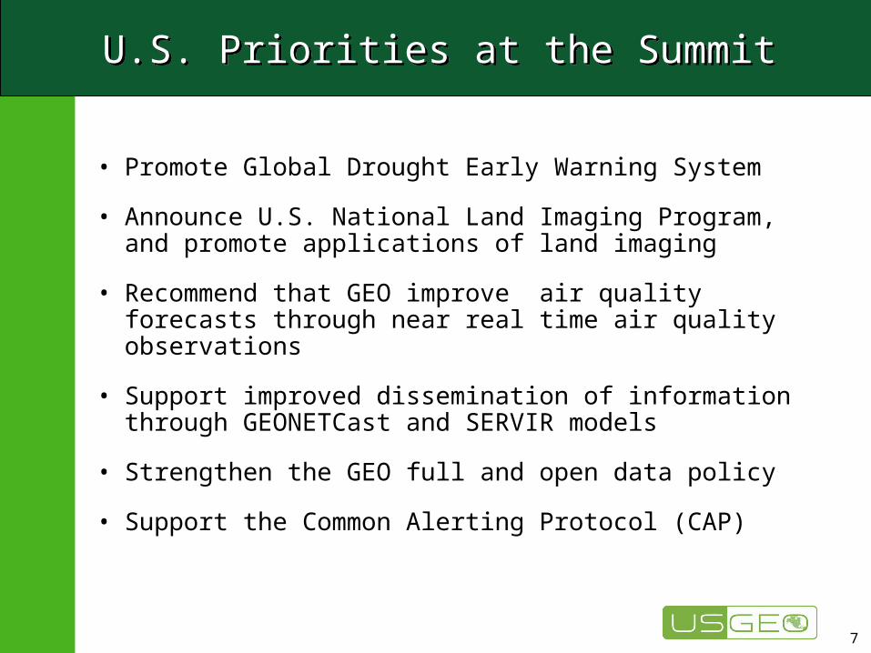
U.S. Priorities at the SummitU.S. Priorities at the Summit
• Promote Global Drought Early Warning System
• Announce U.S. National Land Imaging Program, and promote applications of land imaging
• Recommend that GEO improve air quality forecasts through near real time air quality observations
• Support improved dissemination of information through GEONETCast and SERVIR models
• Strengthen the GEO full and open data policy
• Support the Common Alerting Protocol (CAP)

Indian Ocean DART Conceptual Design 2005
Deep-ocean Assessment & Reporting of Tsunami- an early GEO achievement
Deep-ocean Assessment & Reporting of Tsunami- an early GEO achievement
Global DART Operational Network April 2007
DART II Buoy
8
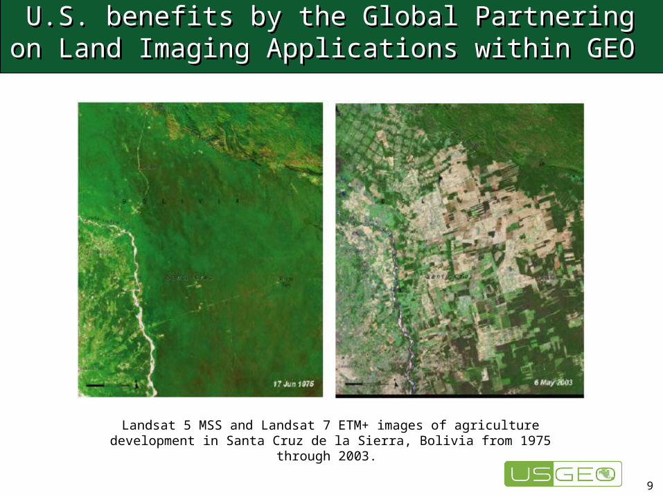
U.S. benefits by the Global Partnering on Land Imaging Applications within GEO
U.S. benefits by the Global Partnering on Land Imaging Applications within GEO
Landsat 5 MSS and Landsat 7 ETM+ images of agriculture development in Santa Cruz de la Sierra, Bolivia from 1975 through 2003.
9

10
U.S. GEO Involvement: A National Integrated Drought Information System
U.S. GEO Involvement: A National Integrated Drought Information System
U.S. Western Governor’s Association
– 1996: Recommendation: U.S. to prepare for, respond to drought – 2000: Creation of National Drought Policy Commission– 2003: NOAA Partnership on drought monitoring & forecasting– 2004: Formal document published recommending NIDIS
Subcommittee on Disaster Reduction, President’s National Science & Technology Council
– 2005: Highlighted drought as one of the grand challenges in disaster reduction• Proposed action: development of an implementation plan for NIDIS
U.S. Integrated Earth Observation System– 2005: NIDIS identified by USGEO as near term opportunity
11
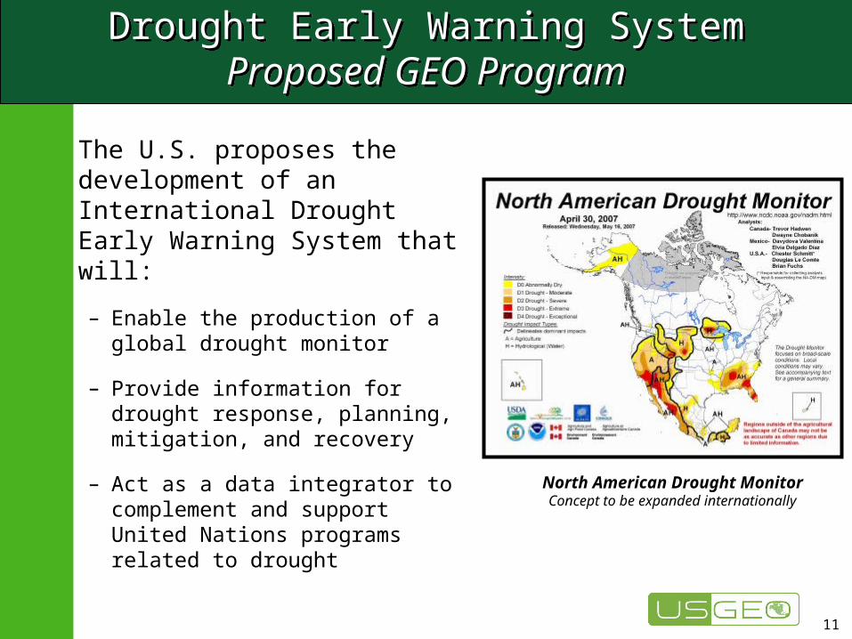
Drought Early Warning SystemProposed GEO Program
Drought Early Warning SystemProposed GEO Program
The U.S. proposes the development of an International Drought Early Warning System that will:
– Enable the production of a global drought monitor
– Provide information for drought response, planning, mitigation, and recovery
– Act as a data integrator to complement and support United Nations programs related to drought
North American Drought MonitorConcept to be expanded internationally

12
Understanding and Adapting to Climate Variability and ChangeUnderstanding and Adapting to Climate Variability and Change
USGEO recognizes that the need to monitor the Earth’s climate on an ongoing basis remains one of the highest priorities of the international community.
With a focus on integrating observing system data to useful and accessible information, the State of the Climate Report, developed by the US, the WMO and other international partners, serves as a hallmark achievement of GEOSS efforts to use integrated global Earth observations to monitor and enhance the understanding of climate variability and change.

13
USGEO Strategic Assessment Group
Analyze observational capabilities versus requirements (gap analysis)
Identify Critical Earth Obs. Requirements by SBAs
Identify Existing and Planned Capabilities
Document requirements and candidate observing
system capabilities
Review Societal Benefit Areas (SBAs) Linkages to Agencies
Integrate Requirements
Integrate Gap Analysis
Recommend Strategic Investments
Ph
ase
IP
has
e II
Ph
ase
III
External Stakeholders Forum
External Stakeholders Forum
Process
Inform Stakeholders of Activity
Collect Input from Stakeholders
Data
Collecti
on
Data
Com
pilati
on
Inte
gra
tion
an
dre
com
men
dati
on
s

14
14
DESDynILaunch 2010-2013
CLARREOLaunch 2010-2013
ACELaunch 2013-2016
ASCENDSLaunch 2013-2016
ICESat-IILaunch 2010-2013
Societal Challenge: Climate PredictionRobust estimates of primary climate forcings for improved climate forecasts, including local predictions of the effects of climate change
CO2 measurements: Day/night, all seasons, all latitudes
Connection between climate and CO2 exchange
Aerosol and cloud types and properties
Changes in carbon storage in vegetation
Estimate of flux of low-salinity ice out of Arctic basin
Absolute spectrally resolved IR radiance
Incident solar and spectrally resolved reflected irradiance
GACMLaunch 2016-2020
Vertical profile of ozone and key ozone precursors
GPSRO Launch 2010-2013
Pressure/ temperature/ water vapor profiles
Decadal Survey Recommendations
Decadal Survey Recommendations

15
15
SMAPLaunch 2010-2013
ACELaunch 2013-2016
GPSROLaunch 2010-2013
3D-WindsLaunch 2020+
PATHLaunch 2016-2020
XOVWMLaunch 2013-2016
Societal Challenge: Improved Weather PredictionLonger-term, more reliable weather forecasts
Three dimensional tropospheric wind profiles
Hurricane wind fieldsSea surface
temperature
Temperature and humidity profilesHigh
resolution ocean vector winds
Pressure/ temperature/ water vapor profiles
Cloud and aerosol height
Linkage between terrestrial water, energy, and carbon cycle
Decadal Survey Recommendations
16
Major Economies Meeting & GEOSSMajor Economies Meeting & GEOSS
• President Bush hosted a Major Economies Meeting recently to discuss a framework for a post 2012 climate initiative.– The President specifically stated:
“By next summer, heads of state should convene to finalize a long-term goal for reducing global greenhouse gas emissions and to establish strong and transparent systems for measuring progress.”
• Clearly the work we are doing through GEO will have a role in facilitating how we measure progress.
17
Major Economies Meeting & GEOSSMajor Economies Meeting & GEOSS
• In remarks at the UNGA High Level Event on Climate Technology Session. Secretary Rice acknowledged the contribution of GEOSS toward this effort.
“Improved technology can play a key role in our efforts to build more resilient societies. One advancement in this area is the Global Earth Observation System of Systems, an important partnership we have advanced with more than 70 developing and developed countries to address the world's most pressing environmental and biological challenges.”

18
Preparation for Earth ObservationSummit
• Secretary Kempthorne will lead U.S. Delegation • USGEO coordinating Agency participation at Summit
– Coordinating Summit and Plenary delegations– Preparing Summit and Plenary U.S. positions– Preparing National report for GEO Summit– Coordinating a common USGEO exhibit at the Summit– Coordinating pre Summit events in the U.S. , eg Media
Roundtable– Submitted 13 papers for GEO Early Achievements– Submitted 10 papers for GEO “Full Picture”
• USGEO lead shaping of the GEO Summit – GEO Progress Report– GEO Declaration– GEO Exhibits and Press

19
SummarySummary
• Global environmental information is key to more informed socio-economic decision making in U.S.
• GEOSS is one the Administration’s key environmental priorities
• Next Earth Observation Summit will take significant steps in ensuring that GEO members cooperate on issues important to the U.S. such as climate, land imaging applications, drought, air quality and data sharing policy

Natural & Human Induced Disasters
Human Health & Well-Being
Energy Resources
Climate Variability & Change
Water Resources
Weather Information, Forecasting & Warning
Ecosystems
Sustainable Agriculture &
Desertification
Oceans
Benefits of Earth ObservationsBenefits of Earth Observations
20