Carbonate Depositional Systems: Assessing...
24
Carbonate Depositional Systems: Assessing Dimensions and Controlling Parameters
Transcript of Carbonate Depositional Systems: Assessing...

Carbonate Depositional Systems: Assessing Dimensions and Controlling Parameters

s
Hildegard Westphal ● Bernhard RieglGregor P. EberliEditors
Carbonate Depositional Systems: Assessing Dimensions and Controlling Parameters
The Bahamas, Belize and the Persian/Arabian Gulf

EditorsHildegard WestphalUniversity of [email protected]
Gregor P. EberliUniversity of MiamiMiami, [email protected]
Bernhard RieglNova Southeastern UniversityDania, [email protected]
ISBN 978-90-481-9363-9 e-ISBN 978-90-481-9364-6DOI 10.1007/978-90-481-9364-6Springer Dordrecht Heidelberg London New York
Library of Congress Control Number: 2010932327
© Springer Science+Business Media B.V. 2010No part of this work may be reproduced, stored in a retrieval system, or transmitted in any form or by any means, electronic, mechanical, photocopying, microfilming, recording or otherwise, without written permission from the Publisher, with the exception of any material supplied specifically for the purpose of being entered and executed on a computer system, for exclusive use by the purchaser of the work.
Printed on acid-free paper
Springer is part of Springer Science+Business Media (www.springer.com)
v
Preface
This book was initiated by a study conducted at Rosenstiel School for Marine and Atmospheric Sciences for Shell Research. For the present book this study has been considerably enlarged and modified.
The book has benefited from discussions with numerous colleagues, and numer-ous colleagues have provided us with unpublished data and information. Without this support, this book would not have been possible.
Numerous colleagues have reviewed parts of the manuscript. Gerald Friedman has reviewed the concept of the book. The Bahamas chapter has been reviewed by Paul Enos, Pascal Kindler, André Strasser, and Peter Swart. The Belize chapter has been reviewed by Ian MacIntyre, Ed Purdy, and Eberhard Gischler. The Persian Gulf chapter has been reviewed by Tony Lomando and Christopher Kendall. Further reviews of various parts of the book were done by Paul Wright, Fred Read, Mitch Harris, and Bob Ginsburg. To all these colleagues we would like to extend our gratefulness. Sonja Felder and Anastasios Stathakopoulos are acknowledged for proof-reading and formatting the manuscript.
We would also like to gratefully acknowledge the support by the late Wolfgang Engel of Springer Verlag who accompanied the first preparation of this book and who did not live to see it finalized. Suzanne Mekking and Martine van Bezooijen then accompanied the project from the manuscript to the book you hold in your hands now.
January 2010 Hildegard WestphalBernhard Riegl
Gregor P. Eberli

s
vii
Contents
1 Parameters Controlling Modern Carbonate Depositional Environments: Approach ......................................................................... 1Hildegard Westphal, Gregor P. Eberli, and Bernhard Riegl
2 Controlling Parameters on Facies Geometries of the Bahamas, an Isolated Carbonate Platform Environment .......... 5Kelly L. Bergman, Hildegard Westphal, Xavier Janson, Anthony Poiriez, and Gregor P. Eberli
3 Belize: A Modern Example of a Mixed Carbonate-Siliciclastic Shelf .................................................................... 81Donald F. McNeill, Xavier Janson, Kelly L. Bergman, and Gregor P. Eberli
4 The Gulf: Facies Belts, Physical, Chemical, and Biological Parameters of Sedimentation on a Carbonate Ramp ............................ 145Bernhard Riegl, Anthony Poiriez, Xavier Janson, and Kelly L. Bergman
5 Summary: The Depositional Systems of the Bahamas, Belize Lagoon and The Gulf Compared ................................................. 215Gregor P. Eberli and Hildegard Westphal
Index ................................................................................................................. 231

s
1H. Westphal et al. (eds.), Carbonate Depositional Systems: Assessing Dimensions and Controlling Parameters, DOI 10.1007/978-90-481-9364-6_1, © Springer Science+Business Media B.V. 2010
First research on carbonate depositional environments dates back to the middle of the nineteenth century, when Nelson (1853) described the general morphology of the Bahamas and realized the origin of calcareous eolianites. However, systematic studies on carbonate sediments and particularly their modern analogues remained scarce until the 1950th and 1960th. Then, pioneer work on the modern (sub-) tropical carbo-nate depositional environment, that was triggered by research groups of several large petroleum companies, ignited a boom in carbonate research (among others: Ginsburg 1956, 1957; Ginsburg and Lloyd 1956; Lowenstam and Epstein 1957; Newell and Rigby 1957; Wells 1957; Purdy 1961, 1963; Imbrie and Purdy 1962).
Despite a great increase in knowledge on carbonate despositional environments, understanding ancient carbonate rocks still remains challenging for the simple reason that the carbonate depositional environment is a dynamic system that responds to a variety of parameters such as climate (humidity, temperature), nutrient availability, productivity, sea level changes, tectonic movements, changes in water and wind energy, and biological determinants. Within this dynamic system, the multitude of parameters is interdependent and superimposed upon each other, and individual processes cannot be easily separated in the rock record. As a result, although exten-sively studied, the relative importance of the various parameters on the stratigraphic architecture of carbonates is still poorly understood.
The goal of this book is to add to the understanding of the carbonate depositional environment and to close some of the still existing gaps in our understanding of the
H. Westphal (*) MARUM and Department of Geosciences, Universität Bremen, Germany e-mail: [email protected]
G.P. Eberli Rosenstiel School for Marine and Atmospheric Sciences, University of Miami, Miami, Florida, USA e-mail: [email protected]
B. Riegl National Coral Reef Institute, Nova Southeastern University, Dania Beach, Florida, USA e-mail: [email protected]
Chapter 1Parameters Controlling Modern Carbonate Depositional Environments: Approach
Hildegard Westphal, Gregor P. Eberli, and Bernhard Riegl
2 H. Westphal et al.
influence and interplay of individual parameters. It is written by geologists for geologists in order to provide an easily accessible overview over the large amount of relevant information provided by the neighboring sciences. Therefore, our view is strongly biased towards what we considered helpful for the interpretation of the sedimentary record. We do not claim the book to be a complete oceanographic, biological and geological review. For our task we concentrate on modern carbonate deposition, because separating the individual parameters is easiest in the modern environment where physical and biological parameters can be measured and directly compared with the actual properties of a depositional body. The approach of this book is to construct an image of modern depositional environments of three classical areas of carbonate deposition, in order to assess both, the range of physical, biological and chemical parameters, and their sedimentary response. This book presents a compre-hensive compilation based on data from published work and from unpublished theses, and the integration of these data in order to extract previously undiscovered relationships between the discussed parameters and carbonate deposition.
This book concentrates on classical (sub-)tropical carbonate and mixed carbon-ate-siliciclastic depositional environments. Today there is growing awareness of the presence of other types of carbonate producing environments such as the cool- to cold-water realm (e.g., Lees and Buller 1972; Nelson et al. 1988; James and Clarke 1997; Freiwald 1998; Hageman et al. 2000; James et al. 2005) and the deep sea (e.g., Lazier et al. 1999; Freiwald and Roberts 2005), but also of the influence of nutrient levels on the development of different types of carbonate platforms (e.g., Pomar 2001). The (sub-)tropical environments presented here are under-stood as end-members of the wide range of carbonate platform types of the present-day world and the rock record. To expand this approach to the other carbonate depositional environments remains for the future.
The three study areas described here were chosen to represent different environ-mental settings of (sub-)tropical carbonate deposition:
1. The Bahamian Archipelago consists of several isolated carbonate platforms on a passive continental margin in a humid climate.
2. The Belize Lagoon is a rimmed carbonate shelf with various amounts of sili-ciclastics admixed. It is located in a strike-slip tectonic regime in a humid climate.
3. The Gulf is a flooded foreland basin, but is often considered a classical carbonate ramp. It is situated in an arid climate, contains evaporites and is influenced by siliciclastics.
For each study area the following parameters are investigated:
– Tectonic setting: structural constraints, terrestrial influence – Physical environmental parameters: wave energy and direction, tidal range,
currents, wind, water temperature, water clarity, depth of photic zone – Chemical parameters: nutrient supply, ocean chemistry, carbonate saturation
state, salinity

31 Parameters Controlling Modern Carbonate Depositional Environments: Approach
– Biological parameters: richness of calcifying fauna, ecological reaction to physical and chemical parameters
– Geometries of various facies belts: width, length, height, grain size, distribution, dominant organisms, slope gradients.
In addition to assessing the influence of these parameters within each of the three depositional environments, a comparison of the three study areas provides new insights in their relevance for carbonates in general. This comparison reveals inter-esting similarities and differences between the three sites.
References
Freiwald A (1998) Modern nearshore cold-temperate calcareous sediments in the Troms district, northern Norway. J Sed Res 68:763–776
Freiwald A, Roberts JM (eds) (2005) Cold-water corals and ecosystems. Springer Verlag, Berlin, Heidelberg
Ginsburg RN (1956) Environmental relationships of grain size and constituent particles in some South Florida carbonate sediments. AAPG Bull 40:2384–2427
Ginsburg RN (1957) Early diagenesis and lithification of shallow water carbonate sediments in South Florida: In: Le Blanc RJ, Breeding JG (eds) Regional aspects of carbonate sedimenta-tion. SEPM Spec Publ 5:80–100
Ginsburg RN, Lloyd RM (1956) A manual piston coring device for use in shallow water. J Sed Petrol 26:64–66
Hageman SJ, James NP, Bone Y (2000) Cool-water carbonate production from epizoic bryozoans on ephemeral substrates. Palaios 15:33–48
Imbrie J, Purdy EG (1962) Classification of modern Bahamian sediments. In: Ham WE (ed) Classification of carbonate rocks. AAPG Mem 1:253–272
James NP, Clarke J (eds) (1997) Cool-water carbonates. SEPM Spec Publ 56:440James NP, Bone Y, Kyser TK (2005) Where has all the aragonite gone? Mineralogy of Holocene
neritic cool-water carbonates, Southern Australia. J Sed Res 75:454–463Lazier AV, Smith JE, Risk MJ, Schwarcz HP (1999) The skeletal structure of Desmophyllum
cristagalli: The use of deep-water corals in sclerochronology. Lethaia 32:119–130Lees A, Buller AT (1972) Modern temperate water and warm water shelf carbonate sediments
contrasted. Mar Geol 13:M67–M73Lowenstam HA, Epstein S (1957) On the origin of sedimentary aragonite needles of the Great
Bahama Bank. J Geol 65:364–375Nelson RJ (1853) On the geology of the Bahamas and on coral formation generally. Geol Soc
London Quart J 9:200–215Nelson CS, Keane SL, Head PS (1988) Non-tropical carbonate deposits on the modern New
Zealand shelf. Sediment Geol 60:71–94Newell ND, Rigby JK (1957) Geological studies in the Great Bahama Bank. In: Le Blanc RJ,
Breeding JG (eds) Regional aspects of carbonate sedimentation. SEPM Spec Publ 5:15–79Pomar L (2001) Types of carbonate platforms: a genetic approach. Basin Res 13:313–334Purdy EG (1961) Bahamian oolite shoals. In: Peterson JA, Osmond JC (eds) Geochemistry of
sandstone bodies. AAPG Spec Vol: 53–63Purdy EG (1963) Recent calcium carbonate facies of the Great Bahama-Bank, I and II. J Geol
71:334–355Wells JW (1957) Coral reefs. GSA Mem 67:609–631
5H. Westphal et al. (eds.), Carbonate Depositional Systems: Assessing Dimensions and Controlling Parameters, DOI 10.1007/978-90-481-9364-6_2, © Springer Science+Business Media B.V. 2010
2.1 Introduction and Research History
The Bahamas are among the most extensively studied carbonate regions in the world, and a number of phenomena typical of calcareous environments have been first observed in the Bahamas. Early geological research in the Bahamas was under-taken by Nelson (1853) who surveyed their geography and topography. He noticed the “remarkable lowness of profile” and the dynamics of construction and destruction of the islands, outlined the biota and lithologies, described the formation of the carbonate rocks, and noticed the eolian origin of many Bahamian islands. Forty years later, the examination of modern carbonate environments rapidly progressed with the expedition of L. and A. Agassiz in 1893 (Agassiz 1894). Their explora-tions focused mainly on the fringing reefs of GE Great Bahama Bank. Research on abiotic carbonate components followed, by Vaughan (1914) who emphasized that
K.L. Bergman (*) ETC Chevron Corporation, San Ramon, California, USA and Rosenstiel School for Marine and Atmospheric Sciences, University of Miami, Miami, Florida, USA e-mail: [email protected]
A. Poiriez and G.P. Eberli Rosenstiel School for Marine and Atmospheric Sciences, University of Miami, Miami, Florida, USA e-mail: [email protected]
H. Westphal Department of Geosciences, Universität Bremen, Germany e-mail: [email protected]
X. Janson Bureau of Economic Geology, Austin, Texas, USA and Rosenstiel School for Marine and Atmospheric Sciences, University of Miami, Miami, Florida, USA e-mail: [email protected]
Chapter 2Controlling Parameters on Facies Geometries of the Bahamas, an Isolated Carbonate Platform Environment
Kelly L. Bergman, Hildegard Westphal, Xavier Janson, Anthony Poiriez, and Gregor P. Eberli

6 K.L. Bergman et al.
carbonate constituents can originate from both skeletal secretion and chemical precipitation, and introduced the terms “organic” and “inorganic” limestones. Black (1933) first characterized the sedimentary facies on Great Bahama Bank and noted the significance of the widespread aragonitic mud. The sand-sized calcareous components of the Bahamas and their origin, including ooid sands, were described in detail in the classic papers by Illing (1954) and Newell et al. (1960).
In the 1960s, the Shell research group led by Robert Ginsburg significantly advanced our understanding of carbonate systems. Important work coming out of this research group included publications by Dunham (1962) who established the first classification of carbonate rocks, and Ball (1967) who classified sand bodies according to their geometry and setting. At the same time, Purdy (1963a, b) made a thorough petrological study of the carbonate facies on GBB addressing the distribution, origin and composition of carbonate sediments. The paleoclimatic significance of humid versus arid tidal flats was recognized by Shinn et al. (1969) and Ginsburg (1976). Enos (1974) compiled available data to produce a facies classification and map of surface sediments of the banks (see Section 2.5).
Work in the 1970s and 1980s incorporated the slope and basins surrounding the shal-low banks and the effect of sea-level on platform growth. Hine and Neumann (1977) characterized the energy balance associated with platform margins and used subsurface data to reveal the internal structure and growth of the banks. Mullins and Neumann (1979) classified bank margins and characteristics of leeward and windward margins. Schlager and Chermak (1979) described the platform-basin transition while Schlager and Ginsburg (1981) elaborated on slope and deep-water trough evolution surrounding the Bahamas. Mullins et al. (1984) used geophysical and coring tools to capture comprehensively the anatomy of the open-ocean platform slope north of Little Bahama Bank.
Many questions surrounding the long-term evolution of Great Bahama Bank were revealed on the first deep-penetrating seismic profiles. Eberli and Ginsburg (1987, 1989) recognized the internal structure of the Bahamas and the role of lateral progradation in their growth. Subsequent drilling of the margins documented the influence of relative sea-level on the prograding pulses and the diagenesis in the shallow subsurface (Schlager et al. 1994; Eberli et al. 1997a; Ginsburg 2001).
The well-studied Bahamian platforms have long been considered the type setting of platform carbonates and are the basis of now classical depositional models for car-bonate deposition in general. However, there still is surprisingly little process-oriented understanding about the effect and interaction of different parameters influencing carbonate production and deposition. Here a comprehensive compilation of data is attempted in order to unravel some of the potential interrelationships between the dif-ferent parameters and to provide a useful database for further research.
2.1.1 Morphology
The remarkable flat and shallow morphology of the Bahamas was noticed by Spanish explorers. Herrera (1601; in the English translation by Stevens 1726) wrote about the

72 Controlling Parameters on Facies Geometries of the Bahamas
reconnaissance of Ponce de Leon in 1513: “… they went out from the islets (…), navigating among some islands he took to be overflowed and found it to be Bahama”. Craton (1986) remarks that “it is an interesting fact that bajamar means shallow (strictly “low tide”) in Spanish. Herrera was probably quoting the name given to the islands by the Spanish between 1513 and 1601”. The name of the Bahamian archipelago thus refers to a morphological description.
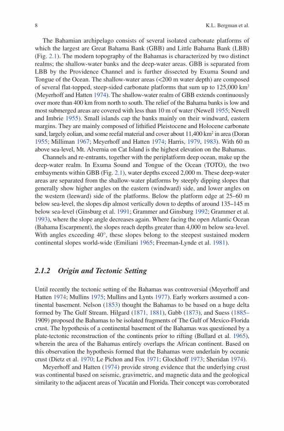
The Bahamian archipelago extends from the Straits of Florida to the Puerto Rico Trench (Fig. 2.1). It is located between 20° and 28° N at the southeastern continental margin of the North American plate, which formed during the Jurassic when Laurasia broke up and the North Atlantic started to form. The Bahamas presently receive virtually no siliciclastic input, except in the form of windblown dust, due to the deep channels surrounding the platforms, resulting in a pure carbonate system that is considered the classical example for an isolated carbonate environment.
Fig. 2.1 Setting of the modern Bahamas at the western margin of the tropical North Atlantic, to the north of the Caribbean. LBB = Little Bahama Bank and GBB = Great Bahama Bank are the major platforms of the Bahamian system that also includes the smaller Turks and Caicos plat-forms. Other islands and platforms: AC = Acklins; AI = Andros Island; BI = Berry Islands; BM = Bimini; CC = Cat Cay; CI = Cat Island; CR = Crooked Island; CSB = Cay Sal Bank; ELI = Eleuthera Island; EI = Exuma Islands; GAI = Great Abaco Island; GBI = Great Bahama Island; IN = Great and Little Inagua; JC = Joulters Cays; LI = Long Island; MA = Mayaguana; MO = Mouchoir; NP = New Providence; SS = San Salvador. Oceanographic features: BBE = Blake-Bahama Escarpment; ES = Exuma Sound; FS = Florida Straits; NEPC = Northeast Providence Channel; NWPC = Northwest Providence Channel; OBC = Old Bahama Channel; SC = Santaren Channel; TOTO = Tongue of the Ocean; WP = Windward Passage
8 K.L. Bergman et al.
The Bahamian archipelago consists of several isolated carbonate platforms of which the largest are Great Bahama Bank (GBB) and Little Bahama Bank (LBB) (Fig. 2.1). The modern topography of the Bahamas is characterized by two distinct realms; the shallow-water banks and the deep-water areas. GBB is separated from LBB by the Providence Channel and is further dissected by Exuma Sound and Tongue of the Ocean. The shallow-water areas (<200 m water depth) are composed of several flat-topped, steep-sided carbonate platforms that sum up to 125,000 km2 (Meyerhoff and Hatten 1974). The shallow-water realm of GBB extends continuously over more than 400 km from north to south. The relief of the Bahama banks is low and most submerged areas are covered with less than 10 m of water (Newell 1955; Newell and Imbrie 1955). Small islands cap the banks mainly on their windward, eastern margins. They are mainly composed of lithified Pleistocene and Holocene carbonate sand, largely eolian, and some reefal material and cover about 11,400 km2 in area (Doran 1955; Milliman 1967; Meyerhoff and Hatten 1974; Harris, 1979, 1983). With 60 m above sea-level, Mt. Alvernia on Cat Island is the highest elevation on the Bahamas.
Channels and re-entrants, together with the periplatform deep ocean, make up the deep-water realm. In Exuma Sound and Tongue of the Ocean (TOTO), the two embayments within GBB (Fig. 2.1), water depths exceed 2,000 m. These deep-water areas are separated from the shallow-water platforms by steeply dipping slopes that generally show higher angles on the eastern (windward) side, and lower angles on the western (leeward) side of the platforms. Below the platform edge at 25–60 m below sea-level, the slopes dip almost vertically down to depths of around 135–145 m below sea-level (Ginsburg et al. 1991; Grammer and Ginsburg 1992; Grammer et al. 1993), where the slope angle decreases again. Where facing the open Atlantic Ocean (Bahama Escarpment), the slopes reach depths greater than 4,000 m below sea-level. With angles exceeding 40°, these slopes belong to the steepest sustained modern continental slopes world-wide (Emiliani 1965; Freeman-Lynde et al. 1981).
2.1.2 Origin and Tectonic Setting
Until recently the tectonic setting of the Bahamas was controversial (Meyerhoff and Hatten 1974; Mullins 1975; Mullins and Lynts 1977). Early workers assumed a con-tinental basement. Nelson (1853) thought the Bahamas to be based on a huge delta formed by The Gulf Stream. Hilgard (1871, 1881), Gabb (1873), and Suess (1885–1909) proposed the Bahamas to be isolated fragments of The Gulf of Mexico-Florida crust. The hypothesis of a continental basement of the Bahamas was questioned by a plate-tectonic reconstruction of the continents prior to rifting (Bullard et al. 1965), wherein the area of the Bahamas entirely overlaps the African continent. Based on this observation the hypothesis formed that the Bahamas were underlain by oceanic crust (Dietz et al. 1970; Le Pichon and Fox 1971; Glockhoff 1973; Sheridan 1974).
Meyerhoff and Hatten (1974) provide strong evidence that the underlying crust was continental based on seismic, gravimetric, and magnetic data and the geological similarity to the adjacent areas of Yucatán and Florida. Their concept was corroborated
92 Controlling Parameters on Facies Geometries of the Bahamas
by Mullins and Lynts (1977) who resolved the overlap problem by a pre-rift recon-struction involving rotation of the region, thus obtaining a perfect fit.
Connected to the question of the nature of the underlying crust, the striking present-day morphology of the Bahamas was subject to a second long-lasting controversy. Three general concepts were proposed in the literature: (1) the concept of an inherited tectonic structure, (2) the concept of an inherited erosional morphol-ogy, and (3) the concept of a constructional Cretaceous carbonate system:
1. It was long believed that the recent morphology reflects an underlying, buried relief inherited from basement structures like folds or faults (e.g. Talwani et al. 1960; Ball et al. 1969; Lynts 1970; Sheridan 1971, 1974, 1976; Uchupi et al. 1971; Glockhoff 1973; Mullins and Lynts 1977). These fault structures were thought to be related to the Jurassic rifting (Mullins and Lynts 1977) or a volcanic precursor topography (Schuchert 1935). Rifting would have produced a horst and graben topography whereby the horsts formed the foundation for the platforms.
2. Hess (1933, 1960) assumed a subaerial erosional relief like a drainage pattern as precursor morphology. Ericsson et al. (1952), Gibson and Schlee (1967), and Andrews et al. (1970) suggested the deep Bahama channels to be essentially val-leys eroded in the submarine environment by slumping and turbidity currents.
3. The concept of a constructional origin of the morphology was based on a com-parison of the steep marginal profiles to the vertical growth of Pacific atolls (Newell 1955). Dietz et al. (1970), Paulus (1972), and Dietz and Holden (1973) thought the present-day morphology is inherited from reef development in the early Late Cretaceous. The so-called “megabank” concept states that the modern patterns result from disintegration of a much larger carbonate platform in the Cretaceous (Paulus 1972; Schlager and Ginsburg 1981; Sheridan et al. 1981). The megabank is thought to have drowned during the Mid-Cretaceous. According to this concept, the modern platform configuration are isolated remanents on the drowned platform (Schlager and Ginsburg 1981).
In contrast to the three aforementioned concepts that assume an upward growth after the establishment of the platform without considerable lateral migration of the margins, Ball (1967, 1972) suggested that the basement structure probably did not contribute much to vertical relief. He stated that any precursor structure most likely has been significantly modified. The existence of a Cretaceous megabank underlying LBB was corroborated by ODP Leg 101 but also showed that the Providence Channel was a long-lived deep-water re-entrant (Leg 101 Scientific Party 1988). Additionally, the results of ODP Leg 101 and a re-evaluation of core Great Isaac-1 revealed that in contrast to the more static concepts, some margins of the Northwest Bahamas have migrated laterally over 10 km since the Miocene (Schlager et al. 1985; Leg 101 Scientific Party 1988; Schlager et al. 1988).
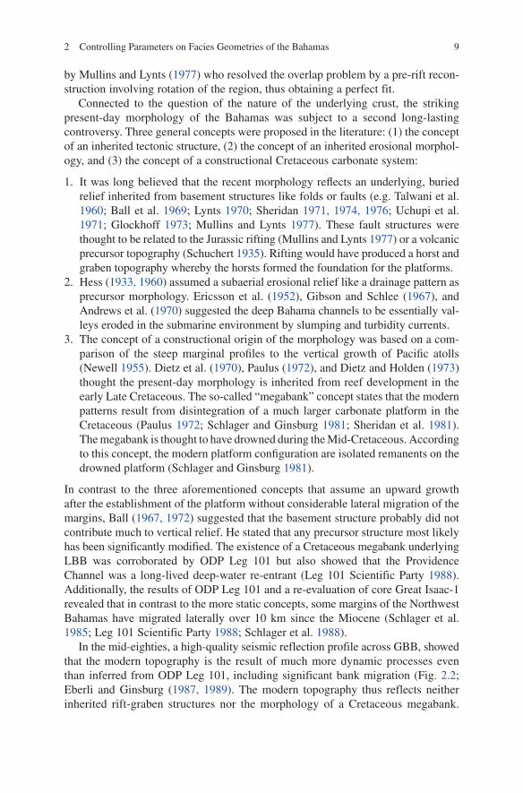
In the mid-eighties, a high-quality seismic reflection profile across GBB, showed that the modern topography is the result of much more dynamic processes even than inferred from ODP Leg 101, including significant bank migration (Fig. 2.2; Eberli and Ginsburg (1987, 1989). The modern topography thus reflects neither inherited rift-graben structures nor the morphology of a Cretaceous megabank.
10 K.L. Bergman et al.
The modern northwest GBB evolved from a process of repeated tectonic segmenta-tion, related to rifting and reactivation of tectonic movements associated with the collision of the North American plate with Cuba, and subsequent coalescence by progradation (Eberli and Ginsburg 1987; Masaferro and Eberli 1999; Masaferro et al. 1999). For example, a former deep channel termed the Straits of Andros by Eberli and Ginsburg (1987) had similar dimensions as the Tongue of the Ocean and was completely filled and incorporated into the GBB. Similar infilled seaways exist in the southern GBB where a left-lateral strike-slip fault system had created several depressions in the Late Cretaceous and Early Tertiary (Masaferro and Eberli 1999). In addition, lateral growth on the leeward side of GBB led to progradation of more than 25 km westward into the Straits of Florida since the Miocene. Since the Cretaceous, the repeated tectonic segmentation and subsequent coalescence, induced by the high productivity of the shallow-water carbonate factory, led to the progressive modification of the GBB. Thus, coalescence and progradation are the most striking features governing the development of this carbonate platform.
Offbank sedimentation, which is a basic process of progradational deposition, is observed on the present-day Bahamas. Even though the environmental conditions on the Bahamas have not been the same for the entire history of the archipelago, an understanding of the present-day system is crucial for an understanding of the past. In the following, parameters controlling carbonate production and deposition in the present-day environment are described and discussed.
2.2 Physical Parameters
Physical parameters that directly or indirectly affect the carbonate depositional system include wave energy, direction of wave propagation, tidal range, currents, wind, and temperature. Generally, in the Bahamas, the physical parameters that influence water energy are most influential at the bank margins (Illing 1954). There, the highest degree of kinetic energy interacts with existing topography and
Fig. 2.2 Interpretation of seismic section through Great Bahama Bank displaying the compli-cated internal architecture of the bank. Two nuclear banks, Andros and Bimini Banks, coalesced by the infilling of an intraplatform seaway, the Straits of Andros. Progradation of the western margin of the platform during the Neogene expanded the bank more than 25 km into the Straits of Florida (Modified after Eberli et al. 1994)
WSM ENE
Mid-Cretaceous Mid-Cretaceous
Mid-MioceneMid-Miocene
Mid-Oligocene
Mid-CretK/T K/T
Mid-Miocene
ProgradationProgradation
Aggradation
Aggradation
Aggradation
Straits of Florida Bimini Bank Straits of Andros Andros Bank
20 km
0.5
1.0
2.0
km
112 Controlling Parameters on Facies Geometries of the Bahamas
biological barriers (e.g. sand shoals, reefs). Variability in exposure to water energy along the bank margins is responsible for the differences in margin architecture and the distribution of facies belts, especially carbonate sand bodies (Ball 1967; Hine and Neumann 1977; Hine et al. 1981b).
2.2.1 Climate
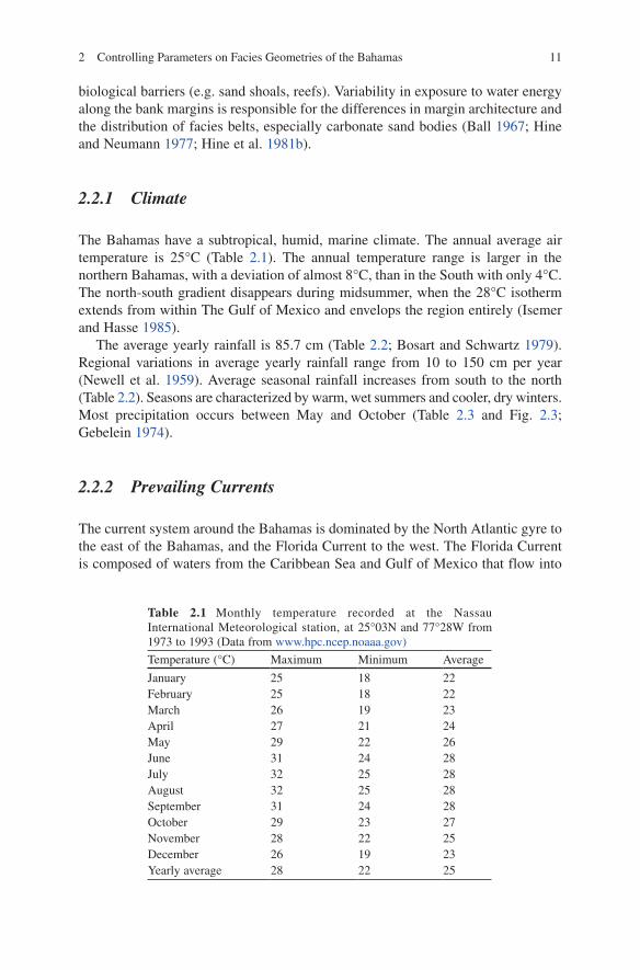
The Bahamas have a subtropical, humid, marine climate. The annual average air temperature is 25°C (Table 2.1). The annual temperature range is larger in the northern Bahamas, with a deviation of almost 8°C, than in the South with only 4°C. The north-south gradient disappears during midsummer, when the 28°C isotherm extends from within The Gulf of Mexico and envelops the region entirely (Isemer and Hasse 1985).
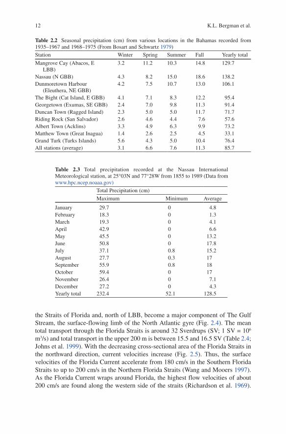
The average yearly rainfall is 85.7 cm (Table 2.2; Bosart and Schwartz 1979). Regional variations in average yearly rainfall range from 10 to 150 cm per year (Newell et al. 1959). Average seasonal rainfall increases from south to the north (Table 2.2). Seasons are characterized by warm, wet summers and cooler, dry winters. Most precipitation occurs between May and October (Table 2.3 and Fig. 2.3; Gebelein 1974).
2.2.2 Prevailing Currents
The current system around the Bahamas is dominated by the North Atlantic gyre to the east of the Bahamas, and the Florida Current to the west. The Florida Current is composed of waters from the Caribbean Sea and Gulf of Mexico that flow into
Table 2.1 Monthly temperature recorded at the Nassau International Meteorological station, at 25°03N and 77°28W from 1973 to 1993 (Data from www.hpc.ncep.noaaa.gov)
Temperature (°C) Maximum Minimum Average
January 25 18 22February 25 18 22March 26 19 23April 27 21 24May 29 22 26June 31 24 28July 32 25 28August 32 25 28September 31 24 28October 29 23 27November 28 22 25December 26 19 23Yearly average 28 22 25
12 K.L. Bergman et al.
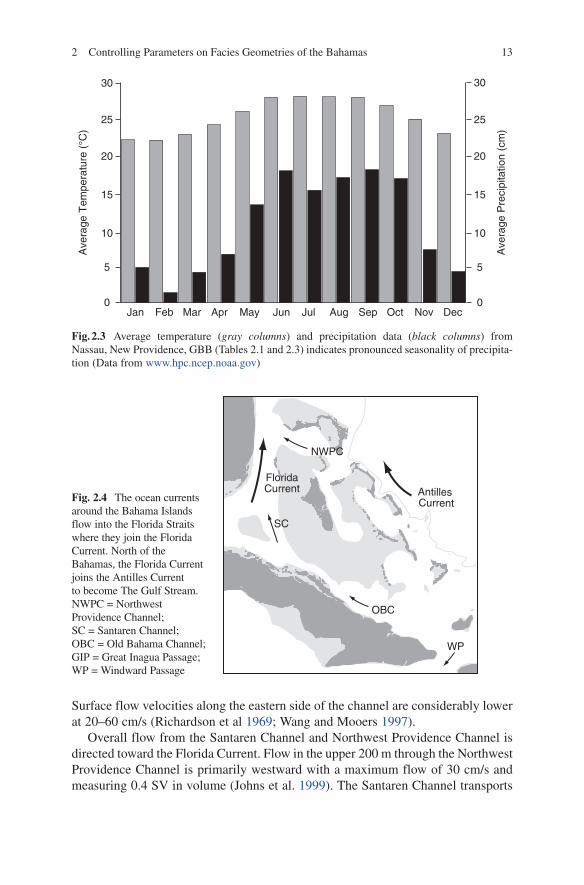
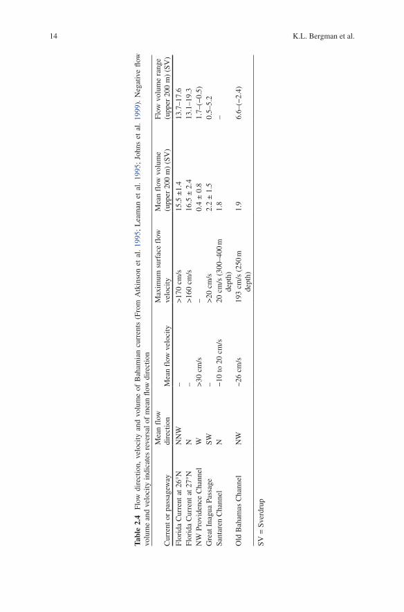
the Straits of Florida and, north of LBB, become a major component of The Gulf Stream, the surface-flowing limb of the North Atlantic gyre (Fig. 2.4). The mean total transport through the Florida Straits is around 32 Sverdrups (SV; 1 SV = 106 m3/s) and total transport in the upper 200 m is between 15.5 and 16.5 SV (Table 2.4; Johns et al. 1999). With the decreasing cross-sectional area of the Florida Straits in the northward direction, current velocities increase (Fig. 2.5). Thus, the surface velocities of the Florida Current accelerate from 180 cm/s in the Southern Florida Straits to up to 200 cm/s in the Northern Florida Straits (Wang and Mooers 1997). As the Florida Current wraps around Florida, the highest flow velocities of about 200 cm/s are found along the western side of the straits (Richardson et al. 1969).
Table 2.2 Seasonal precipitation (cm) from various locations in the Bahamas recorded from 1935–1967 and 1968–1975 (From Bosart and Schwartz 1979)
Station Winter Spring Summer Fall Yearly total
Mangrove Cay (Abacos, E LBB)
3.2 11.2 10.3 14.8 129.7
Nassau (N GBB) 4.3 8.2 15.0 18.6 138.2Dunmoretown Harbour
(Eleuthera, NE GBB)4.2 7.5 10.7 13.0 106.1
The Bight (Cat Island, E GBB) 4.1 7.1 8.3 12.2 95.4Georgetown (Exumas, SE GBB) 2.4 7.0 9.8 11.3 91.4Duncan Town (Ragged Island) 2.3 5.0 5.0 11.7 71.7Riding Rock (San Salvador) 2.6 4.6 4.4 7.6 57.6Albert Town (Acklins) 3.3 4.9 6.3 9.9 73.2Matthew Town (Great Inagua) 1.4 2.6 2.5 4.5 33.1Grand Turk (Turks Islands) 5.6 4.3 5.0 10.4 76.4All stations (average) 3.1 6.6 7.6 11.3 85.7
Table 2.3 Total precipitation recorded at the Nassau International Meteorological station, at 25°03N and 77°28W from 1855 to 1989 (Data from www.hpc.ncep.noaaa.gov)
Total Precipitation (cm)
Maximum Minimum Average
January 29.7 0 4.8February 18.3 0 1.3March 19.3 0 4.1April 42.9 0 6.6May 45.5 0 13.2June 50.8 0 17.8July 37.1 0.8 15.2August 27.7 0.3 17September 55.9 0.8 18October 59.4 0 17November 26.4 0 7.1December 27.2 0 4.3Yearly total 232.4 52.1 128.5
132 Controlling Parameters on Facies Geometries of the Bahamas
30
25
20
15
10
5
0Jan Feb Mar Apr May Jun Jul Aug Sep Oct Nov Dec
30
25
20
15
10
5
0
Ave
rage
Tem
pera
ture
(°C
)
Ave
rage
Pre
cipi
tatio
n (c
m)
Fig. 2.3 Average temperature (gray columns) and precipitation data (black columns) from Nassau, New Providence, GBB (Tables 2.1 and 2.3) indicates pronounced seasonality of precipita-tion (Data from www.hpc.ncep.noaa.gov)
Surface flow velocities along the eastern side of the channel are considerably lower at 20–60 cm/s (Richardson et al 1969; Wang and Mooers 1997).
Overall flow from the Santaren Channel and Northwest Providence Channel is directed toward the Florida Current. Flow in the upper 200 m through the Northwest Providence Channel is primarily westward with a maximum flow of 30 cm/s and measuring 0.4 SV in volume (Johns et al. 1999). The Santaren Channel transports
Fig. 2.4 The ocean currents around the Bahama Islands flow into the Florida Straits where they join the Florida Current. North of the Bahamas, the Florida Current joins the Antilles Current to become The Gulf Stream. NWPC = Northwest Providence Channel; SC = Santaren Channel; OBC = Old Bahama Channel; GIP = Great Inagua Passage; WP = Windward Passage
WP
OBC
SC
Antilles Current
FloridaCurrent
NWPC
14 K.L. Bergman et al.
Tabl
e 2.
4 Fl
ow d
irec
tion,
vel
ocity
and
vol
ume
of B
aham
ian
curr
ents
(Fr
om A
tkin
son
et a
l. 19
95;
Lea
man
et
al.
1995
; Jo
hns
et a
l. 19
99).
Neg
ativ
e flo
w
volu
me
and
velo
city
indi
cate
s re
vers
al o
f m
ean
flow
dir
ectio
n
Cur
rent
or
pass
agew
ayM
ean
flow
di
rect
ion
Mea
n fl
ow v
eloc
ityM
axim
um s
urfa
ce f
low
ve
loci
tyM
ean
flow
vol
ume
(upp
er 2
00 m
) (S
V)
Flow
vol
ume
rang
e (u
pper
200
m)
(SV
)
Flor
ida
Cur
rent
at 2
6°N
NN
W–
>17
0 cm
/s15
.5 ±
1.4
13.7
–17.
6Fl
orid
a C
urre
nt a
t 27°
NN
–>
160
cm/s
16.5
± 2
.413
.1–1
9.3
NW
Pro
vide
nce
Cha
nnel
W>
30 c
m/s
–0.
4 ±
0.8
1.7–
(−0.
5)G
reat
Ina
gua
Pass
age
SW–
>20
cm
/s2.
2 ±
1.5
0.5–
5.2
Sant
aren
Cha
nnel
N−
10 to
20
cm/s
20 c
m/s
(30
0–40
0 m
de
pth)
1.8
–
Old
Bah
amas
Cha
nnel
NW
~26
cm/s
193
cm/s
(25
0 m
de
pth)
1.9
6.6–
(−2.
4)
SV =
Sve
rdru
p
152 Controlling Parameters on Facies Geometries of the Bahamas
about 1.8 Sv of water northward at a maximum velocity of 20 cm/s (Leaman et al. 1995). Flow velocities in the Old Bahama Channel are on average 26 cm/s with transport of 1.9 SV northwestward (Atkinson et al. 1995). Flow through the Great Inagua Passage is to the southwest totaling 2.2 SV in the uppermost 200 m and has a maximum velocity of 30–40 cm/s (Johns et al. 1999). A summary of current flow direction, velocity, and water volume around the Bahamas is listed in Table 2.4.
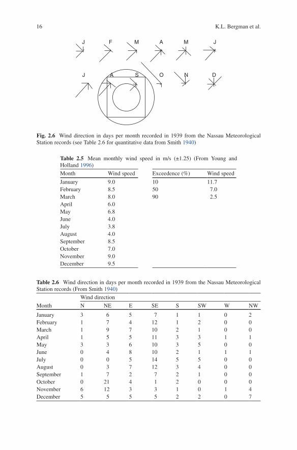
2.2.3 Wind Energy
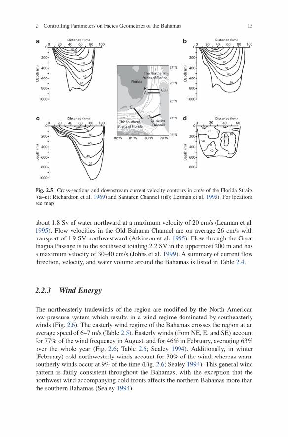
The northeasterly tradewinds of the region are modified by the North American low-pressure system which results in a wind regime dominated by southeasterly winds (Fig. 2.6). The easterly wind regime of the Bahamas crosses the region at an average speed of 6–7 m/s (Table 2.5). Easterly winds (from NE, E, and SE) account for 77% of the wind frequency in August, and for 46% in February, averaging 63% over the whole year (Fig. 2.6; Table 2.6; Sealey 1994). Additionally, in winter (February) cold northwesterly winds account for 30% of the wind, whereas warm southerly winds occur at 9% of the time (Fig. 2.6; Sealey 1994). This general wind pattern is fairly consistent throughout the Bahamas, with the exception that the northwest wind accompanying cold fronts affects the northern Bahamas more than the southern Bahamas (Sealey 1994).
Fig. 2.5 Cross-sections and downstream current velocity contours in cm/s of the Florida Straits ((a–c); Richardson et al. 1969) and Santaren Channel ((d); Leaman et al. 1995). For locations see map
16 K.L. Bergman et al.
Table 2.5 Mean monthly wind speed in m/s (±1.25) (From Young and Holland 1996)
Month Wind speed Exceedence (%) Wind speed
January 9.0 10 11.7February 8.5 50 7.0March 8.0 90 2.5April 6.0May 6.8June 4.0July 3.8August 4.0September 8.5October 7.0November 9.0December 9.5
Table 2.6 Wind direction in days per month recorded in 1939 from the Nassau Meteorological Station records (From Smith 1940)
Wind direction
Month N NE E SE S SW W NW
January 3 6 5 7 1 1 0 2February 1 7 4 12 1 2 0 0March 1 9 7 10 2 1 0 0April 1 5 5 11 3 3 1 1May 3 3 6 10 3 5 0 0June 0 4 8 10 2 1 1 1July 0 0 5 14 5 5 0 0August 0 3 7 12 3 4 0 0September 1 7 2 7 2 1 0 0October 0 21 4 1 2 0 0 0November 6 12 3 3 1 0 1 4December 5 5 5 5 2 2 0 7
Fig. 2.6 Wind direction in days per month recorded in 1939 from the Nassau Meteorological Station records (see Table 2.6 for quantitative data from Smith 1940)
J F M A M J
J A S O N D
172 Controlling Parameters on Facies Geometries of the Bahamas
These persistent wind patterns influence sediment production and accumulation in the long term while tropical storms and hurricanes may also influence sediment redis-tribution in the short term. Depending on intensity, duration, and circulation pattern, storms can erode or deposit sediment (Perkins and Enos 1968). The greatest influence of storms is on non-vegetated, unstabilized environments such as sand bodies. The Tongue of the Ocean is subject to an average of two tropical storms per year, whereas approximately eight tropical storms pass over central LBB during 10 years (Cry 1965). Of all tropical disturbances affecting LBB, 67% pass to the north and east, traveling in a northerly, northwesterly, or westerly direction. They generate dominant winds from the northwest, north, and northeast. The result is a net bankward energy and sediment flux along the northeast bank margin, and a net offbank transport along the leeward margin on LBB (See Section 2.5.1.2; Crutcher and Quayle 1974; Hine and Neumann 1977). Some sand belts might only be active during hurricanes (e.g., tidal-bar belts in the Lily Bank area, Hine 1977; Hine et al. 1981b).
Yet storm influence on facies distribution are generally limited to the superficial and the short-term as ambient energy conditions reestablish pre-storm facies configu-rations (Perkins and Enos 1968; Boss and Neumann 1993; Major et al. 1996; Rankey et al. 2004). A re-examination of deposits on northern GBB after the passage of Hurricane Andrew in 1992 showed minor effects on sand bodies, hard bottom communities, and low-lying islands (Boss and Neumann 1993). In addition, biotur-bation by organisms in vulnerable facies such as lagoonal sediments may destroy any record of winnowed deposits left behind by storms (Perkins and Enos 1968; Boss and Neumann 1993). Shinn et al. (1993) observed that muddy storm layers were preserved in high-energy channel sediments, because migrating ooids prevented obliteration by bioturbation.
Geologists disagree on the degree of impact storms have on the off-bank transport of sediment, because background (not storm-related) currents rarely exceed sediment transport threshold velocity (Cry 1965; Smith and Hopkins 1972). Hine et al. (1981a) suggest that storms are the primary transport mechanism of shallow-water sands found in 200–400 m water depth off the leeward margin of GBB and LBB and cite evidence of offbank oriented sand waves along the bank margins that are only active during storms. They concluded that normal tidal and current flow could not be responsible for carrying the sand to the deep (Hine et al. 1981a). Yet, observations after the passage of Hurricane Andrew over GBB in 1992 and Frances and Jeanne over LBB in 2004 showed that surprisingly little sediment transport was induced by the storm (Major et al. 1996; Reeder and Rankey, 2008).
2.2.4 Wave Energy
Wave energy in the Bahamas is highest along the windward (eastern) margins of the platforms, e.g. at eastern Abaco on LBB, and at Long Island on GBB (Table 2.7). Wave and swell energy arrive along these margins unimpeded from the open Atlantic Ocean. The rest of the Bahamas are exposed to lower wave energy due to either