CAPTAINS CREEK FLOOD STUDY 200-year ARI Storm Event ... · D D D T B U N D O C K S T BELGIAN...
15
WARBURTON ST HUGH ST STURT ST HEATLEYS PDE INGHAM RD CAPE PALLARENDA RD INGHAM RD STANLEY ST B U NDOC K S T BELGIAN GARDENS CASTLE HILL CORAL SEA GARBUTT MOUNT ST JOHN NORTH WARD RAILWAY ESTATE ROWES BAY TOWN COMMON TOWNSVILLE CITY WEST END 0 200 400 600 100 Metres ¹ 1:17,000 (when printed at A3) CAPTAINS CREEK FLOOD STUDY 200-year ARI Storm Event Maximum Water Velocity Figure A-25 Data sources: Road, Rail, Localities - StreetPro© 2010 Property Boundary - QLD Gov 2013 Imagery - QLD Gov 2010 Elevation - TCC 2013 AECOM does not warrant the accuracy or completeness of information displayed in this map and any person using it does so at their own risk. AECOM shall bear no responsibility or liability for any errors, faults, defects, or omissions in the information. www.aecom.com Maximum Water Velocity (m/s) 0 - 0.25 0.25 - 0.50 0.50 - 0.75 0.75 - 1.00 1.00 - 1.25 1.25 - 1.50 1.50 - 1.75 1.75 - 2.00 Above 2 User: mathieu-burrym | Date Saved: 15/05/2014 | FileName: J:\MMPL\60304811\4. Tech Work Area\4.99 GIS\02_MXDs\DRAFT_REPORT_REV0_20140515\60304811_WIS_120_V_DDP.mxd Coordinate System: GDA 1994 MGA Zone 55
Transcript of CAPTAINS CREEK FLOOD STUDY 200-year ARI Storm Event ... · D D D T B U N D O C K S T BELGIAN...

WARBURTON ST
HUGH
ST
STURT ST
HEATLEYS PDE
INGHAM RDCAPE PALLARENDA RD
INGHAM RD
STANLEY ST
BUNDOC
K ST
BELGIANGARDENS
CASTLEHILL
CORALSEA
GARBUTT
MOUNTST JOHN
NORTHWARD
RAILWAYESTATE
ROWESBAY
TOWNCOMMON
TOWNSVILLECITYWEST END0 200 400 600100
Metres ¹1:17,000 (when printed at A3)
CAPTAINS CREEK FLOOD STUDY200-year ARI Storm EventMaximum Water Velocity
Figure A-25
Data sources:Road, Rail, Localities - StreetPro© 2010Property Boundary - QLD Gov 2013 Imagery - QLD Gov 2010Elevation - TCC 2013
AECO
M does
not w
arrant
the ac
curacy
or com
pleten
ess of
informa
tion dis
played
in this
map a
nd any
perso
n usin
g it do
es so
at thei
r own ri
sk. A
ECOM
shall
bear no
respon
sibility
or liab
ility for
any e
rrors,
faults,
defec
ts, or o
missio
ns in t
he info
rmation
.
www.aecom.com
Maximum Water Velocity (m/s)0 - 0.250.25 - 0.500.50 - 0.750.75 - 1.001.00 - 1.251.25 - 1.501.50 - 1.751.75 - 2.00Above 2
User: mathieu-burrym | Date Saved: 15/05/2014 | FileName: J:\MMPL\60304811\4. Tech Work Area\4.99 GIS\02_MXDs\DRAFT_REPORT_REV0_20140515\60304811_WIS_120_V_DDP.mxd
Coordinate System: GDA 1994 MGA Zone 55

WARBURTON ST
HUGH
ST
STURT ST
HEATLEYS PDE
INGHAM RDCAPE PALLARENDA RD
INGHAM RD
STANLEY ST
BUNDOC
K ST
BELGIANGARDENS
CASTLEHILL
CORALSEA
GARBUTT
MOUNTST JOHN
NORTHWARD
RAILWAYESTATE
ROWESBAY
TOWNCOMMON
TOWNSVILLECITYWEST END0 200 400 600100
Metres ¹1:17,000 (when printed at A3)
CAPTAINS CREEK FLOOD STUDY500-year ARI Storm EventMaximum Water Velocity
Figure A-26
Data sources:Road, Rail, Localities - StreetPro© 2010Property Boundary - QLD Gov 2013 Imagery - QLD Gov 2010Elevation - TCC 2013
AECO
M does
not w
arrant
the ac
curacy
or com
pleten
ess of
informa
tion dis
played
in this
map a
nd any
perso
n usin
g it do
es so
at thei
r own ri
sk. A
ECOM
shall
bear no
respon
sibility
or liab
ility for
any e
rrors,
faults,
defec
ts, or o
missio
ns in t
he info
rmation
.
www.aecom.com
Maximum Water Velocity (m/s)0 - 0.250.25 - 0.500.50 - 0.750.75 - 1.001.00 - 1.251.25 - 1.501.50 - 1.751.75 - 2.00Above 2
User: mathieu-burrym | Date Saved: 15/05/2014 | FileName: J:\MMPL\60304811\4. Tech Work Area\4.99 GIS\02_MXDs\DRAFT_REPORT_REV0_20140515\60304811_WIS_120_V_DDP.mxd
Coordinate System: GDA 1994 MGA Zone 55
WARBURTON ST
HUGH
ST
STURT ST
HEATLEYS PDE
INGHAM RDCAPE PALLARENDA RD
INGHAM RD
STANLEY ST
BUNDOC
K ST
BELGIANGARDENS
CASTLEHILL
CORALSEA
GARBUTT
MOUNTST JOHN
NORTHWARD
RAILWAYESTATE
ROWESBAY
TOWNCOMMON
TOWNSVILLECITYWEST END0 200 400 600100
Metres ¹1:17,000 (when printed at A3)
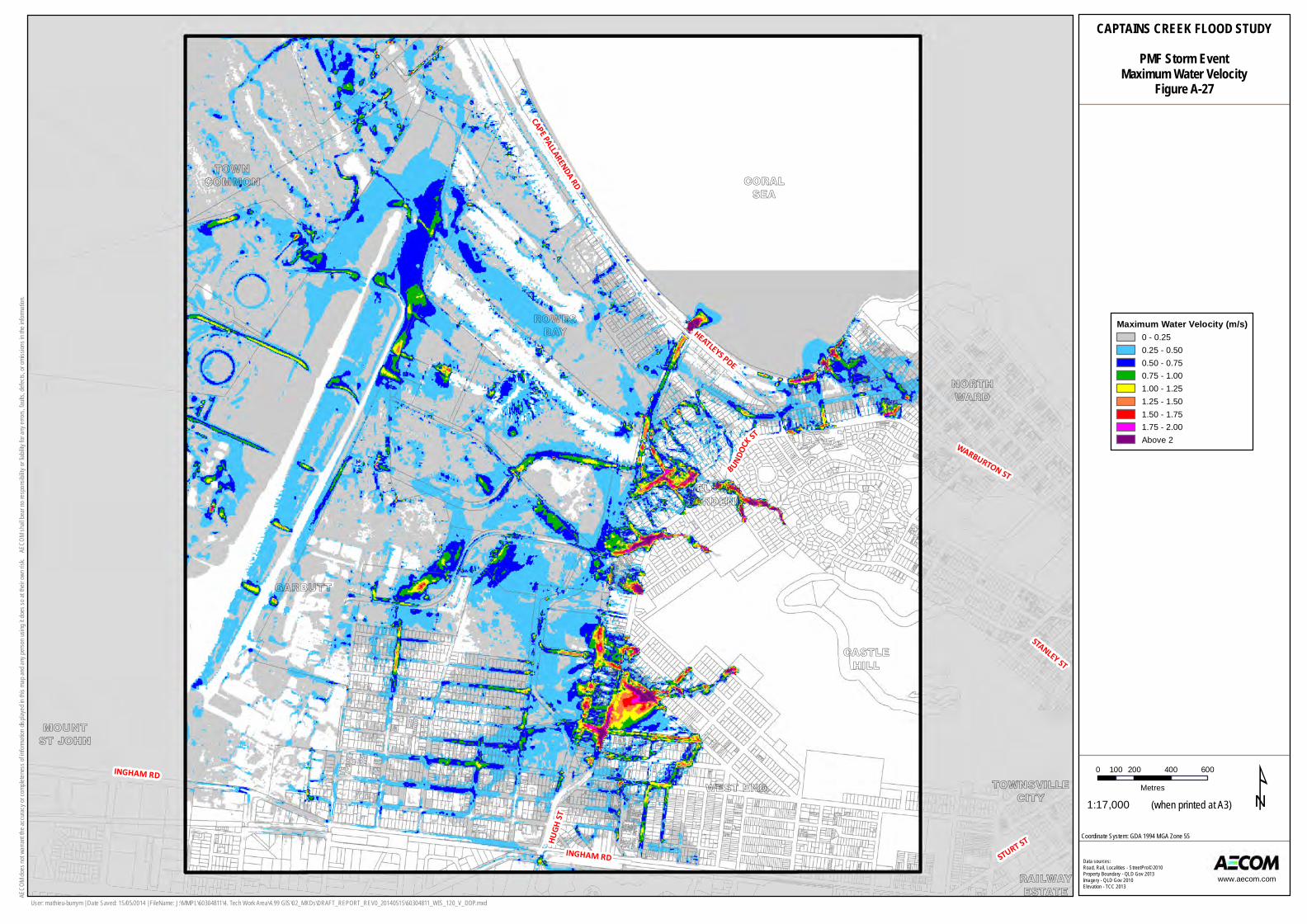
CAPTAINS CREEK FLOOD STUDYPMF Storm Event
Maximum Water VelocityFigure A-27
Data sources:Road, Rail, Localities - StreetPro© 2010Property Boundary - QLD Gov 2013 Imagery - QLD Gov 2010Elevation - TCC 2013
AECO
M does
not w
arrant
the ac
curacy
or com
pleten
ess of
informa
tion dis
played
in this
map a
nd any
perso
n usin
g it do
es so
at thei
r own ri
sk. A
ECOM
shall
bear no
respon
sibility
or liab
ility for
any e
rrors,
faults,
defec
ts, or o
missio
ns in t
he info
rmation
.
www.aecom.com
Maximum Water Velocity (m/s)0 - 0.250.25 - 0.500.50 - 0.750.75 - 1.001.00 - 1.251.25 - 1.501.50 - 1.751.75 - 2.00Above 2
User: mathieu-burrym | Date Saved: 15/05/2014 | FileName: J:\MMPL\60304811\4. Tech Work Area\4.99 GIS\02_MXDs\DRAFT_REPORT_REV0_20140515\60304811_WIS_120_V_DDP.mxd
Coordinate System: GDA 1994 MGA Zone 55

AECOM Captains Creek Flood Study
J:\MMPL\60304811\8. Issued Docs\8.6 Clerical\final copy\report.docx Revision 1 – 06-Jun-2014 Prepared for – Townsville City Council – ABN: 44 741 992 072
Appendix B
Structure Details
AECOM Captains Creek Flood Study
J:\MMPL\60304811\8. Issued Docs\8.6 Clerical\final copy\report.docx Revision 1 – 06-Jun-2014 Prepared for – Townsville City Council – ABN: 44 741 992 072
C
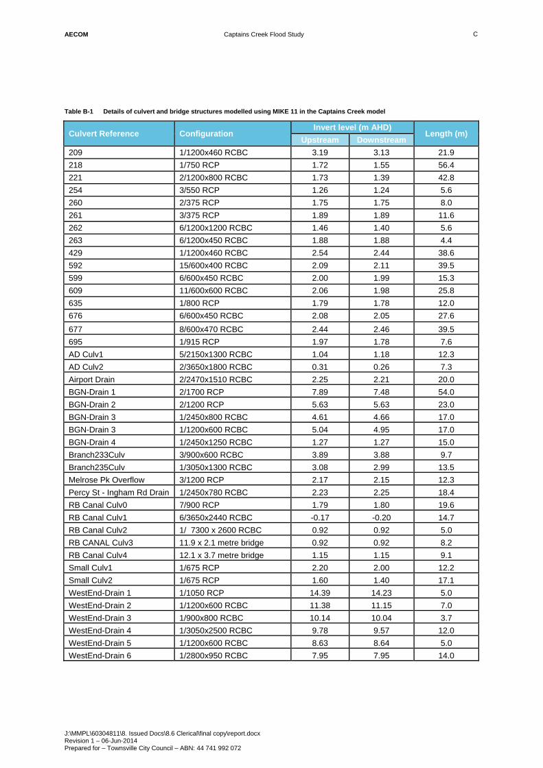
Table B-1 Details of culvert and bridge structures modelled using MIKE 11 in the Captains Creek model
Culvert Reference Configuration Invert level (m AHD)
Length (m) Upstream Downstream
209 1/1200x460 RCBC 3.19 3.13 21.9 218 1/750 RCP 1.72 1.55 56.4 221 2/1200x800 RCBC 1.73 1.39 42.8 254 3/550 RCP 1.26 1.24 5.6 260 2/375 RCP 1.75 1.75 8.0 261 3/375 RCP 1.89 1.89 11.6 262 6/1200x1200 RCBC 1.46 1.40 5.6 263 6/1200x450 RCBC 1.88 1.88 4.4 429 1/1200x460 RCBC 2.54 2.44 38.6 592 15/600x400 RCBC 2.09 2.11 39.5 599 6/600x450 RCBC 2.00 1.99 15.3 609 11/600x600 RCBC 2.06 1.98 25.8 635 1/800 RCP 1.79 1.78 12.0 676 6/600x450 RCBC 2.08 2.05 27.6 677 8/600x470 RCBC 2.44 2.46 39.5 695 1/915 RCP 1.97 1.78 7.6 AD Culv1 5/2150x1300 RCBC 1.04 1.18 12.3 AD Culv2 2/3650x1800 RCBC 0.31 0.26 7.3 Airport Drain 2/2470x1510 RCBC 2.25 2.21 20.0 BGN-Drain 1 2/1700 RCP 7.89 7.48 54.0 BGN-Drain 2 2/1200 RCP 5.63 5.63 23.0 BGN-Drain 3 1/2450x800 RCBC 4.61 4.66 17.0 BGN-Drain 3 1/1200x600 RCBC 5.04 4.95 17.0 BGN-Drain 4 1/2450x1250 RCBC 1.27 1.27 15.0 Branch233Culv 3/900x600 RCBC 3.89 3.88 9.7 Branch235Culv 1/3050x1300 RCBC 3.08 2.99 13.5 Melrose Pk Overflow 3/1200 RCP 2.17 2.15 12.3 Percy St - Ingham Rd Drain 1/2450x780 RCBC 2.23 2.25 18.4 RB Canal Culv0 7/900 RCP 1.79 1.80 19.6 RB Canal Culv1 6/3650x2440 RCBC -0.17 -0.20 14.7 RB Canal Culv2 1/ 7300 x 2600 RCBC 0.92 0.92 5.0 RB CANAL Culv3 11.9 x 2.1 metre bridge 0.92 0.92 8.2 RB Canal Culv4 12.1 x 3.7 metre bridge 1.15 1.15 9.1 Small Culv1 1/675 RCP 2.20 2.00 12.2 Small Culv2 1/675 RCP 1.60 1.40 17.1 WestEnd-Drain 1 1/1050 RCP 14.39 14.23 5.0 WestEnd-Drain 2 1/1200x600 RCBC 11.38 11.15 7.0 WestEnd-Drain 3 1/900x800 RCBC 10.14 10.04 3.7 WestEnd-Drain 4 1/3050x2500 RCBC 9.78 9.57 12.0 WestEnd-Drain 5 1/1200x600 RCBC 8.63 8.64 5.0 WestEnd-Drain 6 1/2800x950 RCBC 7.95 7.95 14.0

AECOM Captains Creek Flood Study
J:\MMPL\60304811\8. Issued Docs\8.6 Clerical\final copy\report.docx Revision 1 – 06-Jun-2014 Prepared for – Townsville City Council – ABN: 44 741 992 072
Appendix C
Long Section Profile for Captains Creek

CAPTAINS CREEK FLOOD STUDYLongitudinal Profile - Captains Creek
50 year ARI 24 hoursFigure C-1
AECO
M does
not w
arrant
the ac
curacy
or com
pleten
ess of
informa
tion dis
played
in this
map a
nd any
perso
n usin
g it do
es so
at thei
r own ri
sk. A
ECOM
shall
bear no
respon
sibility
or liab
ility for
any e
rrors,
faults,
defec
ts, or o
missio
ns in t
he info
rmation
.
www.aecom.com
User: mathieu-burrym | Date Saved: 4/06/2014 | FileName: J:\MMPL\60304811\4. Tech Work Area\4.99 GIS\02_MXDs\DRAFT_REPORT_REV0_20140603\60304811_WIS_300_AppendixC1_LongSection.mxd
2
2.2
2.4
2.6
2.8
3
3.2
3.4
3.6
3.8
4
0 250 500 750 1000 1250 1500 1750 2000 2250 2500 2750
Surfac
e Elev
ation
(m AH
D)
Chainage (m)

WARBURTON ST
HUGH
ST
BUNDOCK ST
STURT ST
PERCY
ST
INGHAM RD
HEATLEYS PDE
INGHAM RD
CAPE PALLARENDA RD
INGHAM RD
STANLEY ST
GREGORY ST
BUNDOC
K ST
CH: 0mCH: 100m
CH: 200mCH: 300m
CH: 400mCH: 500mCH: 600m
CH: 700mCH: 800m
CH: 900mCH: 1000m
CH: 1100mCH: 1200m
CH: 1300mCH: 1400m
CH: 1500mCH: 1600mCH: 1700m
CH: 1800mCH: 1900mCH: 2000mCH: 2100m
CH: 2200mCH: 2300m
CH: 2400mCH: 2500m
CH: 2600mCH: 2700m
CH: 2800m CH: 2900mCH: 3000mCH: 3100m
CH: 3200mCH: 3300m
Louisa Creek
Ross Creek
Lo
uisa
Creek
Louisa Creek
BELGIANGARDENS
CURRAJONG
CORALSEA
CASTLEHILL
HERMITPARK
GARBUTTMOUNTST JOHN
NORTHWARD
MOUNTLOUISAHYDEPARK
TOWNCOMMON
WEST END TOWNSVILLECITY
ROWESBAY
RAILWAYESTATEPIMLICO
0 200 400 600100Metres ¹1:20,000 (when printed at A3)
CAPTAINS CREEK FLOOD STUDYLongitudinal Profile - Captains Creek
Plan ViewFigure C-2
Data sources:Road, Rail, Localities - StreetPro© 2010Property Boundary - QLD Gov 2013 Imagery - QLD Gov 2010Elevation - TCC 2013
AECO
M does
not w
arrant
the ac
curacy
or com
pleten
ess of
informa
tion dis
played
in this
map a
nd any
perso
n usin
g it do
es so
at thei
r own ri
sk. A
ECOM
shall
bear no
respon
sibility
or liab
ility for
any e
rrors,
faults,
defec
ts, or o
missio
ns in t
he info
rmation
.
www.aecom.com
ChainageLongitudinal Section - Captains Creek
Louisa Creek (Blakey's Crossing)Model ExtentGarbutt Drainage Flood Study ModelExtentCaptains Creek Model Extent
User: mathieu-burrym | Date Saved: 3/06/2014 | FileName: J:\MMPL\60304811\4. Tech Work Area\4.99 GIS\02_MXDs\DRAFT_REPORT_REV0_20140603\60304811_WIS_300_AppendixC2_LongSection.mxd
Coordinate System: GDA 1994 MGA Zone 55
AECOM Captains Creek Flood Study
J:\MMPL\60304811\8. Issued Docs\8.6 Clerical\final copy\report.docx Revision 1 – 06-Jun-2014 Prepared for – Townsville City Council – ABN: 44 741 992 072
Appendix D
Photos of Captains Creek Catchment
AECOM Captains Creek Flood Study
J:\MMPL\60304811\8. Issued Docs\8.6 Clerical\final copy\report.docx Revision 1 – 06-Jun-2014 Prepared for – Townsville City Council – ABN: 44 741 992 072
d-1
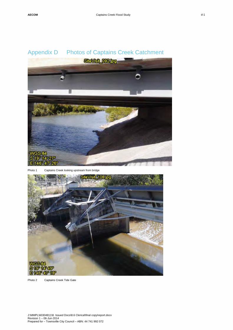
Appendix D Photos of Captains Creek Catchment
Photo 1 Captains Creek looking upstream from bridge
Photo 2 Captains Creek Tide Gate

AECOM Captains Creek Flood Study
J:\MMPL\60304811\8. Issued Docs\8.6 Clerical\final copy\report.docx Revision 1 – 06-Jun-2014 Prepared for – Townsville City Council – ABN: 44 741 992 072
d-2
Photo 3 Chubb Street Drain
Photo 4 Chubb Street Drain

AECOM Captains Creek Flood Study
J:\MMPL\60304811\8. Issued Docs\8.6 Clerical\final copy\report.docx Revision 1 – 06-Jun-2014 Prepared for – Townsville City Council – ABN: 44 741 992 072
d-3
Photo 5 Melrose Park Drain, looking north from Dearness Street (Jan 2014)
Photo 6 Melrose Park Drain, looking south from Dearness Street (Jan 2014)

AECOM Captains Creek Flood Study
J:\MMPL\60304811\8. Issued Docs\8.6 Clerical\final copy\report.docx Revision 1 – 06-Jun-2014 Prepared for – Townsville City Council – ABN: 44 741 992 072
d-4
Photo 7 Melrose Park Drain, downstream of John Melton Black Drive (Cyclone Ita, April 2014)
Photo 8 Melrose Park Drain inundation of Dearness Street (Cyclone Ita, April 2014)

AECOM Captains Creek Flood Study
J:\MMPL\60304811\8. Issued Docs\8.6 Clerical\final copy\report.docx Revision 1 – 06-Jun-2014 Prepared for – Townsville City Council – ABN: 44 741 992 072
d-5
Photo 9 Melrose Park Drain – Hugh Street, looking south from Dearness Street (Cyclone Ita, April 2014)
Photo 10 Percy Street (Cyclone Ita, April 2014)

AECOM Captains Creek Flood Study
J:\MMPL\60304811\8. Issued Docs\8.6 Clerical\final copy\report.docx Revision 1 – 06-Jun-2014 Prepared for – Townsville City Council – ABN: 44 741 992 072
d-6
Photo 11 Melrose Park playing fields (Cyclone Ita, April 2014)
Photo 12 Flooding at Douglas Street, looking north from Dearness Street (Cyclone Ita, April 2014)