SOUTH CENTRAL Coordinated Public Transit & Human Services ...
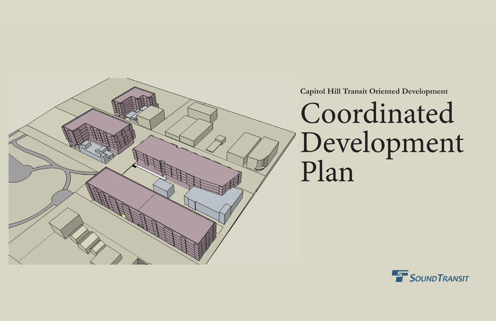
Capitol Hill Transit Oriented Development
Coordinated Development Plan
Capitol Hill Transit Oriented Development Coordinated Development Plan - May 2013
Table of Contents
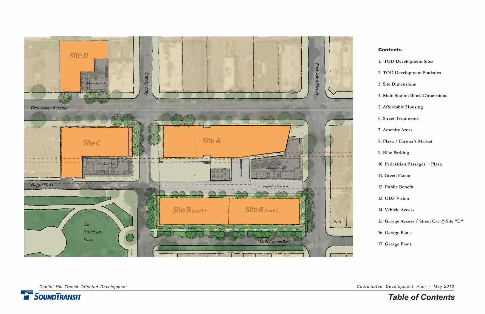
Contents
1. TOD Development Sites
2. TOD Development Statistics
3. Site Dimensions
4. Main Station Block Dimensions
5. Affordable Housing
6. Street Treatments
7. Amenity Areas
8. Plaza / Farmer’s Market
9. Bike Parking
10. Pedestrian Passages + Plaza
11. Green Factor
12. Public Benefit
13. UDF Vision
14. Vehicle Access
15. Garage Access / Street Car @ Site “D”
16. Garage Plans
17. Garage Plans
N
Capitol Hill Transit Oriented Development Coordinated Development Plan - May 2013
Introduction
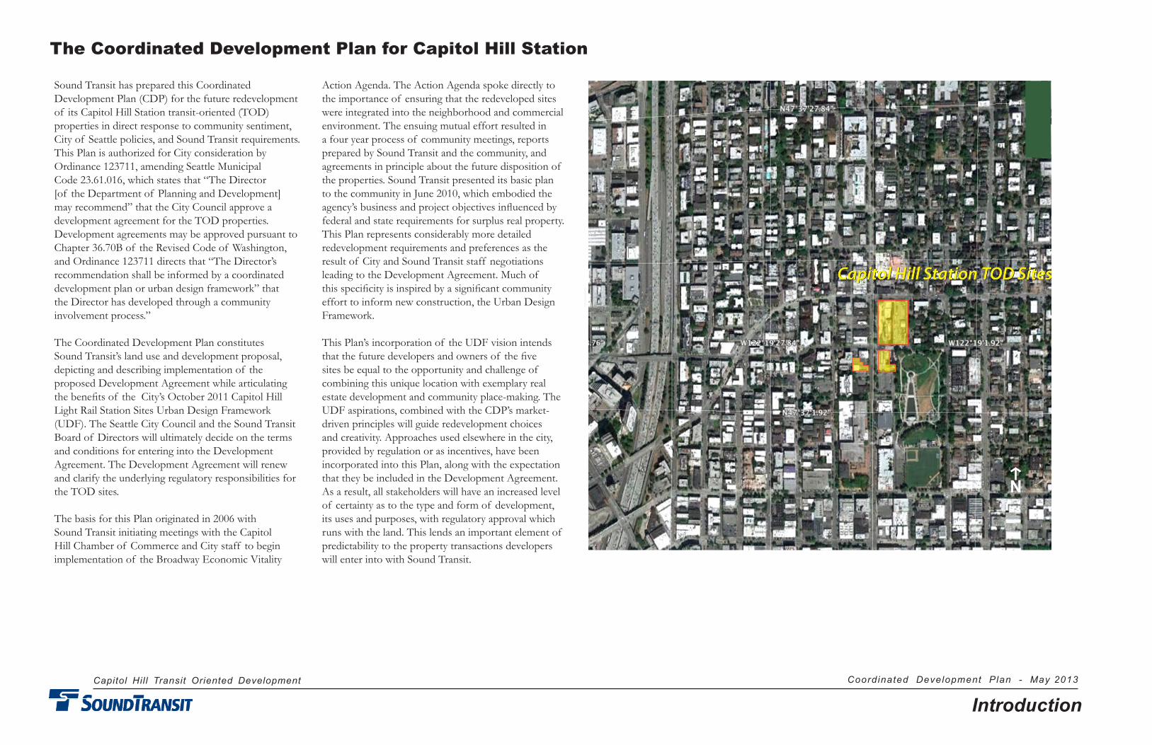
Sound Transit has prepared this Coordinated Development Plan (CDP) for the future redevelopment of its Capitol Hill Station transit-oriented (TOD) properties in direct response to community sentiment, City of Seattle policies, and Sound Transit requirements. This Plan is authorized for City consideration by Ordinance 123711, amending Seattle Municipal Code 23.61.016, which states that “The Director [of the Department of Planning and Development] may recommend” that the City Council approve a development agreement for the TOD properties. Development agreements may be approved pursuant to Chapter 36.70B of the Revised Code of Washington, and Ordinance 123711 directs that “The Director’s recommendation shall be informed by a coordinated development plan or urban design framework” that the Director has developed through a community involvement process.”
The Coordinated Development Plan constitutes Sound Transit’s land use and development proposal, depicting and describing implementation of the proposed Development Agreement while articulating the benefits of the City’s October 2011 Capitol Hill Light Rail Station Sites Urban Design Framework (UDF). The Seattle City Council and the Sound Transit Board of Directors will ultimately decide on the terms and conditions for entering into the Development Agreement. The Development Agreement will re new and clarify the underlying regulatory responsibilities for the TOD sites.
The basis for this Plan originated in 2006 with Sound Transit initiating meetings with the Capitol Hill Chamber of Commerce and City staff to begin implementation of the Broadway Economic Vitality
Action Agenda. The Action Agenda spoke directly to the importance of ensuring that the redeveloped sites were integrated into the neighborhood and commercial environment. The ensuing mutual effort resulted in a four year process of community meetings, reports prepared by Sound Transit and the community, and agreements in principle about the future disposition of the properties. Sound Transit presented its basic plan to the community in June 2010, which embodied the agency’s business and project objectives influenced by federal and state requirements for surplus real property. This Plan represents considerably more detailed redevelopment requirements and preferences as the result of City and Sound Transit staff negotiations leading to the Development Agreement. Much of this speci ficity is inspired by a significant community effort to inform new construction, the Urban Design Framework.
This Plan’s incorporation of the UDF vision intends that the future developers and owners of the five sites be equal to the opportunity and challenge of combining this unique location with exemplary real estate development and community place-making. The UDF aspirations, combined with the CDP’s market-driven principles will guide redevelopment choices and creativity. Approaches used elsewhere in the city, provided by regulation or as incentives, have been incorporated into this Plan, along with the expectation that they be included in the Development Agreement. As a result, all stakeholders will have an increased level of certainty as to the type and form of development, its uses and purposes, with regulatory approval which runs with the land. This lends an important element of predictability to the property transactions developers will enter into with Sound Transit.
The Coordinated Development Plan for Capitol Hill Station
N
Capitol Hill Transit Oriented Development Coordinated Development Plan - May 2013
Introduction
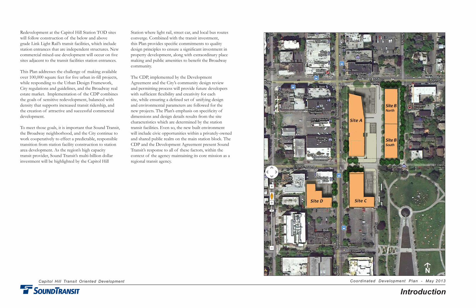
Redevelopment at the Capitol Hill Station TOD sites will follow construction of the below and above grade Link Light Rail’s transit facilities, which include station entrances that are independent structures. New commercial mixed-use development will occur on five sites adjacent to the transit facilities station entrances.
This Plan addresses the challenge of making available over 100,000 square feet for five urban in-fill projects, while responding to the Urban Design Framework, City regulations and guidelines, and the Broadway real estate market. Implementation of the CDP combines the goals of sensitive redevelopment, balanced with density that supports increased transit ridership, and the creation of attractive and successful commercial development.
To meet those goals, it is important that Sound Transit, the Broadway neighborhood, and the City continue to work cooperatively to effect a predictable, responsible transition from station facility construction to station area development. As the region’s high capacity transit provider, Sound Transit’s multi-billion dollar investment will be highlighted by the Capitol Hill
Station where light rail, street car, and local bus routes converge. Combined with the transit investment, this Plan provides specific commitments to quality design principles to ensure a significant investment in property development, along with extraordinary place making and public amenities to benefit the Broadway community.
The CDP, implemented by the Development Agreement and the City’s community design review and permitting process will provide future developers with sufficient flexibility and creativity for each site, while ensuring a defined set of unifying design and environmental parameters are followed for the new projects. The Plan’s emphasis on specificity of dimensions and design details results from the site characteristics which are determined by the station transit facilities. Even so, the new built environment will include civic opportunities within a privately-owned and shared public realm on the main station block. The CDP and the Development Agreement present Sound Transit’s response to all of these factors, within the context of the agency maintaining its core mission as a regional transit agency.
N
Capitol Hill Transit Oriented Development Coordinated Development Plan - May 2013
1TOD Development Sites
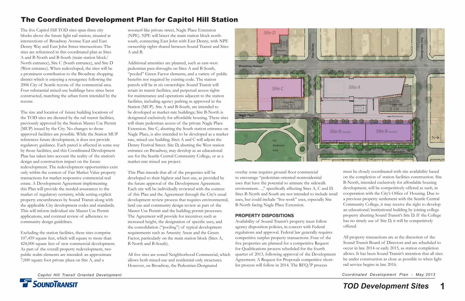
The five Capitol Hill TOD sites span three city blocks above the future light rail station, situated at intersections of Broadway Avenue East and East Denny Way and East John Street intersections. The sites are referenced in this coordinated plan as Sites A and B-North and B-South (main station block/North entrance), Site C (South entrance), and Site D (West entrance). When redeveloped, the sites will be a prominent contribution to the Broadway shopping district which is enjoying a resurgence following the 2006 City of Seattle rezone of the commercial area. Four substantial mixed-use buildings have since been constructed, matching the urban form intended by the rezone.
The size and location of future building locations of the TOD sites are dictated by the rail transit facilities, previously approved by the Station Master Use Permit (MUP) issued by the City. No changes to those approved facilities are possible. While the Station MUP references future development, it does not provide regulatory guidance. Each parcel is affected in some way by those facilities, and this Coordinated Development Plan has taken into account the reality of the station’s design and construction impact on the future redevelopment. The redevelopment opportunities exist only within the context of Fair Market Value property transactions for market-responsive commercial real estate. A Development Agreement implementing this Plan will provide the needed assurances to the market of regulatory certainty, while setting explicit property encumbrances by Sound Transit along with the applicable City development codes and standards. This will inform individual site Master Use Permit applications, and eventual review of adherence to community design guidelines.
Excluding the station facilities, these sites comprise 107,459 square feet, which will equate to more than 424,000 square feet of new commercial development. As part of the overall property redevelopment, two public realm elements are intended: an approximate 7,000 square foot private plaza on Site A, and a
woonerf-like private street, Nagle Place Extension (NPE). NPE will bisect the main station block north-south, connecting East John with East Denny, with NPE ownership rights shared between Sound Transit and Sites A and B.
Additional amenities are planned, such as east-west pedestrian pass-throughs on Sites A and B-South, “pooled” Green Factor elements, and a variety of public benefits not required by existing code. The station parcels will be in six ownerships: Sound Transit will retain its transit facilities, and perpetual access rights for maintenance and operations adjacent to the station facilities, including agency parking as approved in the Station (MUP). Site A and B-South, are intended to be developed as market-rate buildings; Site B-North is designated exclusively for affordable housing. These sites will share pedestrian access of the private Nagle Place Extension. Site C, abutting the South station entrance on Nagle Place, is also intended to be developed as a market-rate, mixed use building. Sites A and C will adjoin the Denny Festival Street. Site D, abutting the West station entrance on Broadway, may develop as an educational use for the Seattle Central Community College, or as a market-rate mixed use project.
This Plan intends that all of the properties will be developed to their highest and best use, as provided by the future approval of the Development Agreement. Each site will be individually reviewed with the context of this Plan and the Agreement through the City’s usual development review process that requires environmental, land use and community design review as part of the Master Use Permit and the building permit processes. The Agreement will provide for incentives such as increased height, the designation of specific uses, and the consolidation (“pooling”) of typical development requirements such as Amenity Areas and the Green Factor, particularly on the main station block (Sites A, B-North and B-South).
All five sites are zoned Neighborhood Commercial, which allows both mixed-use and residential-only structures. However, on Broadway, the Pedestrian-Designated
overlay zone requires ground floor commercial to encourage “pedestrian-oriented nonresidential uses that have the potential to animate the sidewalk environment…,” specifically affecting Sites A, C and D. Sites B-North and South are not intended to include retail uses, but could include “live-work” uses, especially Site B-North facing Nagle Place Extension.
PROPERTY DISPOSITIONSAvailability of Sound Transit’s property must follow agency disposition policies, in concert with Federal regulations and approval. Federal law generally requires competitive surplus property transactions. Four of the five properties are planned for a competitive Request for Qualifications process scheduled for the fourth quarter of 2013, following approval of the Development Agreement. A Request for Proposals competitive short-list process will follow in 2014. The RFQ/P process
The Coordinated Development Plan for Capitol Hill Station
must be closely coordinated with site availability based on the completion of station facilities construction. Site B-North, intended exclusively for affordable housing development, will be competitively offered as such, in cooperation with the City’s Office of Housing. Due to a previous property settlement with the Seattle Central Community College, it may receive the right to develop an educational/institutional building by joining college property abutting Sound Transit’s Site D. If the College has no timely use of Site D, it will be competitively offered.
All property transactions are at the discretion of the Sound Transit Board of Directors and are scheduled to occur in late 2014 or early 2015, as station completion allows. It has been Sound Transit’s intention that all sites be under construction as close as possible to when light rail service begins in late 2016.
N

Capitol Hill Transit Oriented Development Coordinated Development Plan - May 2013
2TOD Development Site Statistics
TOD DEVELOPMENT SITE STATISTICS
Existing regulations would allow all sites to be developed at a maximum Floor Area Ratio of 6.0 FAR. However, site dimensions and other factors such as the transit station facilities prevent the maximum FAR from being achieved. Based on this Plan, all sites are expected to be built at least as the five-over-one (5/1) construction type, at 74’11” maximum height. An exception could be Sites B-North and South, which could use the top floor of a garage structure as the podium, if a parking garage is built across both sites.
On the Broadway frontage sites (A, C and D), the optimal retail experience for the height of the ground floor is between 15 and 20 feet. This dimension is both financially and aesthetically necessary to achieve a “retail window” that provides for an inviting experience on the sidewalk as well as the street. This is consistent with new retail constructed in mixed-use buildings on Broadway. This dimension will be most responsive to market rate retail tenant requirements; the CDP provides for a ground floor recess of four feet, creating a wider sidewalk area.
As a compliment to ground floor environment, the height of the remaining above floors is equally important to creating buildings that stretch each floor based on an interior ceiling height of ten feet. The overall effect of this vertical dimension creates a visually superior exterior façade, while providing commodious interior living spaces for tenants. Five ten-foot residential floors with a retail street level floor at 15 to 20 feet will be most responsive to excellent design and commercial requirements. The overall height in the Development Agreement is proposed to allow sites constructed at 5-over-2, within 85 feet, allowing for an additional floor including affordable housing.
As indicated in the chart on this page, only one of the five sites approaches the allowed maximum floor area ratio (FAR), and only two come close to the allowable 100% lot coverage. Site A, for example, achieves the lowest in both cases in response to providing a larger-than would
be required Amenity Area (or open space) for that parcel. The difference between achieving full and partial lot coverage and less than maximum use of FAR has financial considerations. Those considerations are weighed against publicly accessible, privately owned areas for potential use for bicycle parking, mid-block building pass-throughs connecting the Site A plaza with Broadway and 10th Avenue East, and the potential use by the Broadway Farmers Market.
On the south side of Site A, the building is set back 12 feet to provide a level plaza to compliment and strengthen the place-making aspects of the adjacent Denny Festival Street, with a link to the Broadway retail activity and the plaza east of the building. This private plaza is atop the first floor building plinth, which provides a uniform plane above the sloping Denny Way.
All site dimensions depicted in this Plan are fundamental to meeting the market requirements of building bay depths (standard residential units and corridors), building setbacks necessary to achieve optimal streetscapes, accounting for Amenity Area and Green Factor requirements, and other City codes. Within these detailed dimensions there exist ground level public benefits that are complimentary to the multi-modal transit services at and below street grade. Balcony zones, overhangs above property lines, garden courts, and relationships to curb lines are the same as, or similar to, building construction approved elsewhere by the City.
Even with the site constraints, especially when constructing adjacent to the station facilities, designers will have considerable creative latitude. Conformance will be required with design details in the Development Agreement, as depicted in this Plan, and as a result of the community design guidelines process. The extensive community involvement processes conducted by Sound Transit and the City provide a combined vision for these sites which significantly contributes to creating a unique sense of place within the Capitol Hill community.
Site A Site Area 45,978 Lot Coverage 34%Building Area 134,328Retail Area 21,408Residential Area 112,920Residential Units 132MFTE Units 27Parking Spaces 210FAR 2.92
Site BB – North Site Area 17,158Lot Coverage 72%Building Area 74,120Residential Area 74,120Residential Units 86A�ordable Units 86FAR 4.33
B – South Site Area 16,699Lot Coverage 74%Building Area 72,810Residential Area 72,810Residential Units 85MFTE Units 17Parking Spaces 167+FAR 4.36
Site DSite Area 10,423Lot Coverage 93%Building Area 46,534Retail Area 8,774Residential Area 37,760Residential Units 44MFTE Units 9Parking Spaces 22FAR 4.46
Site Zoning Minimum Total Lot FAR Classi�cation Height Building Coverage AreaA NC3P-65 74'11" 134,328 sf 34% 2.92B-North NC3-40 74'11" 74,210 sf 72% 4.44B-South NC3-40 74'11" 72,810 sf 74% 4.36C NC3P-65 74'11" 96,249 sf 92% 5.59D NC3P-65 74'11" 46,534 sf 93% 4.46 424,131 sf
Site CSite Area 17,231Lot Coverage 92%Building Area 96,249Retail Area 15,784Residential Area 80,465Residential Units 94MFTE Units 19Parking Spaces 26FAR 5.09
Capitol Hill Transit Oriented Development Coordinated Development Plan - May 2013
3TOD Site Dimensions
N
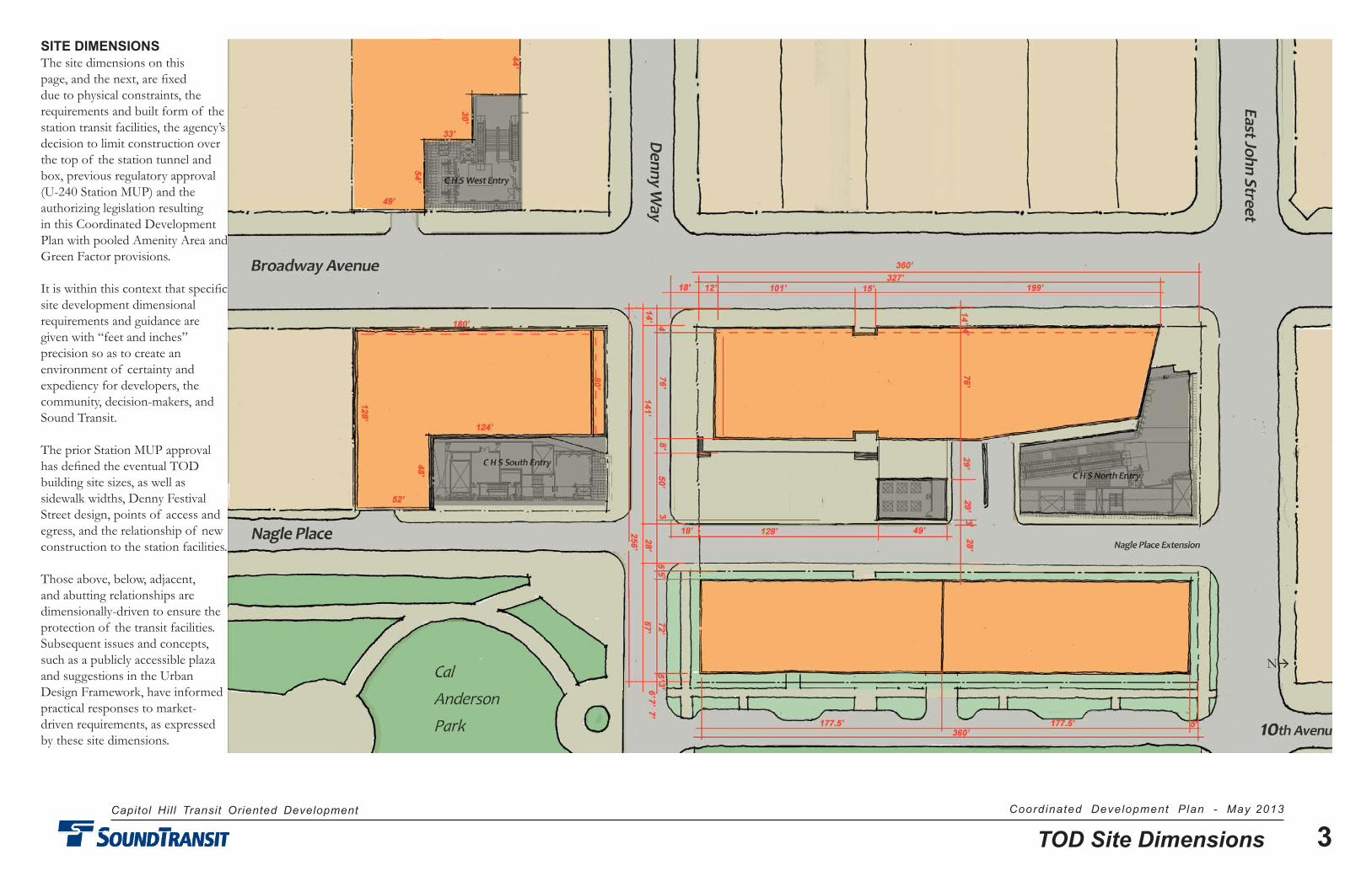
SITE DIMENSIONSThe site dimensions on this page, and the next, are fixed due to physical constraints, the requirements and built form of the station transit facilities, the agency’s decision to limit construction over the top of the station tunnel and box, previous regulatory approval (U-240 Station MUP) and the authorizing legislation resulting in this Coordinated Development Plan with pooled Amenity Area and Green Factor provisions.
It is within this context that specific site development dimensional requirements and guidance are given with “feet and inches” precision so as to create an environment of certainty and expediency for developers, the community, decision-makers, and Sound Transit.
The prior Station MUP approval has defined the eventual TOD building site sizes, as well as sidewalk widths, Denny Festival Street design, points of access and egress, and the relationship of new construction to the station facilities.
Those above, below, adjacent, and abutting relationships are dimensionally-driven to ensure the protection of the transit facilities. Subsequent issues and concepts, such as a publicly accessible plaza and suggestions in the Urban Design Framework, have informed practical responses to market-driven requirements, as expressed by these site dimensions.
Capitol Hill Transit Oriented Development Coordinated Development Plan - May 2013
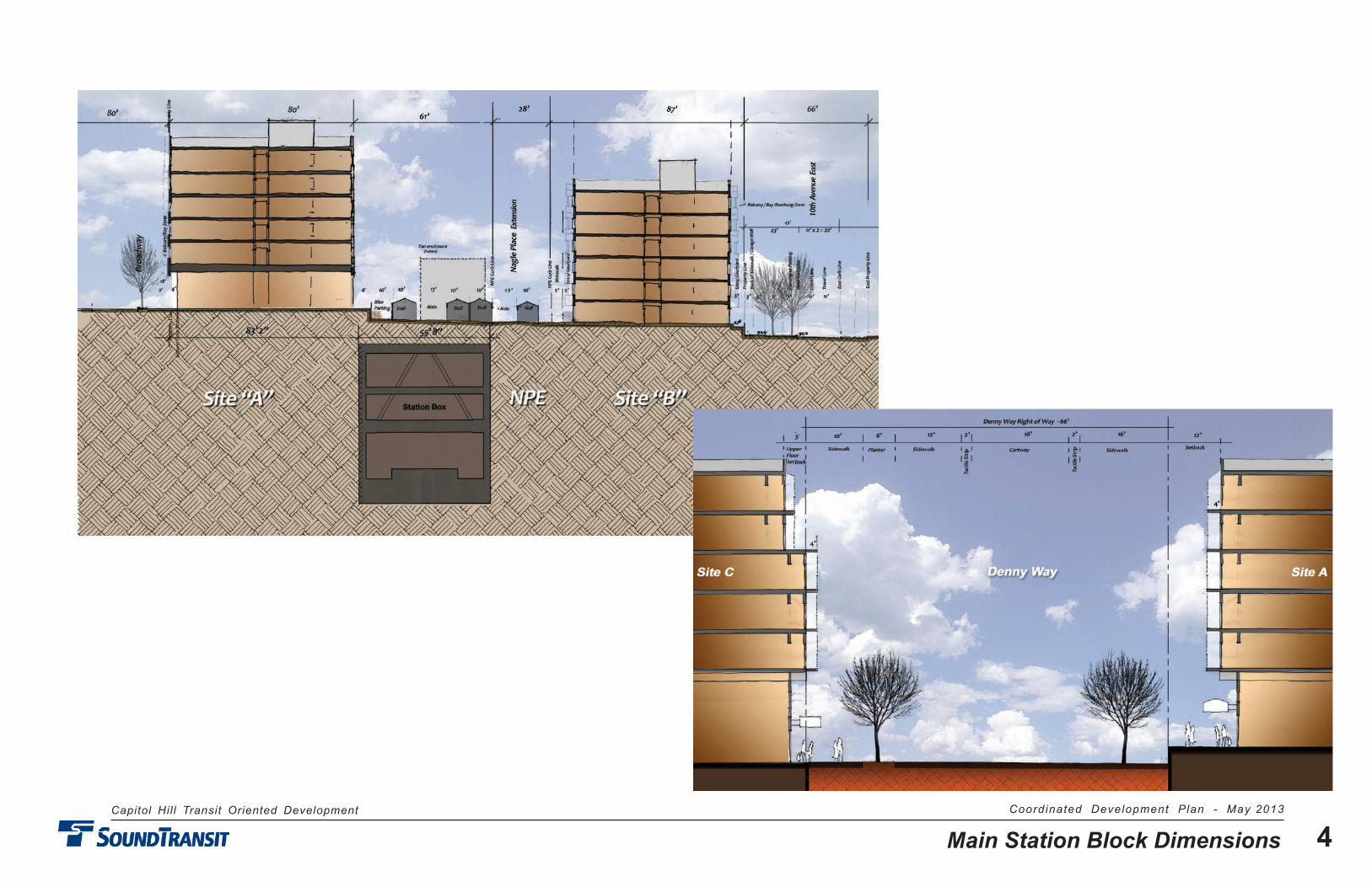
4Main Station Block Dimensions
Capitol Hill Transit Oriented Development Coordinated Development Plan - May 2013
5Affordable Housing
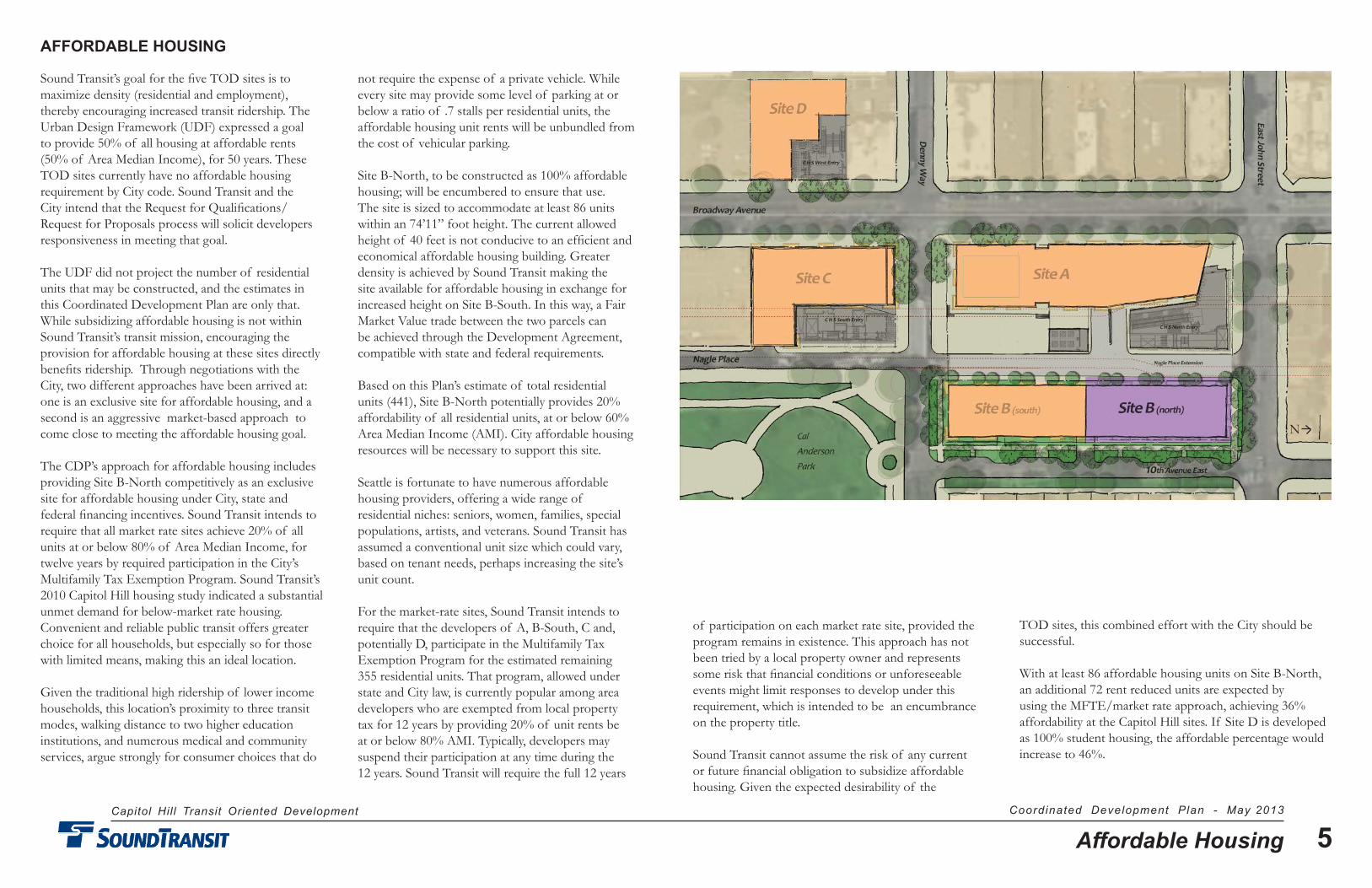
AFFORDABLE HOUSING
Sound Transit’s goal for the five TOD sites is to maximize density (residential and employment), thereby encouraging increased transit ridership. The Urban Design Framework (UDF) expressed a goal to provide 50% of all housing at affordable rents (50% of Area Median Income), for 50 years. These TOD sites currently have no affordable housing requirement by City code. Sound Transit and the City intend that the Request for Qualifications/Request for Proposals process will solicit developers responsiveness in meeting that goal.
The UDF did not project the number of residential units that may be constructed, and the estimates in this Coordinated Development Plan are only that. While subsidizing affordable housing is not within Sound Transit’s transit mission, encouraging the provision for affordable housing at these sites directly benefits ridership. Through negotiations with the City, two different approaches have been arrived at: one is an exclusive site for affordable housing, and a second is an aggressive market-based approach to come close to meeting the affordable housing goal.
The CDP’s approach for affordable housing includes providing Site B-North competitively as an exclusive site for affordable housing under City, state and federal financing incentives. Sound Transit intends to require that all market rate sites achieve 20% of all units at or below 80% of Area Median Income, for twelve years by required participation in the City’s Multifamily Tax Exemption Program. Sound Transit’s 2010 Capitol Hill housing study indicated a substantial unmet demand for below-market rate housing. Convenient and reliable public transit offers greater choice for all households, but especially so for those with limited means, making this an ideal location.
Given the traditional high ridership of lower income households, this location’s proximity to three transit modes, walking distance to two higher education institutions, and numerous medical and community services, argue strongly for consumer choices that do
not require the expense of a private vehicle. While every site may provide some level of parking at or below a ratio of .7 stalls per residential units, the affordable housing unit rents will be unbundled from the cost of vehicular parking.
Site B-North, to be constructed as 100% affordable housing; will be encumbered to ensure that use. The site is sized to accommodate at least 86 units within an 74’11” foot height. The current allowed height of 40 feet is not conducive to an efficient and economical affordable housing building. Greater density is achieved by Sound Transit making the site available for affordable housing in exchange for increased height on Site B-South. In this way, a Fair Market Value trade between the two parcels can be achieved through the Development Agreement, compatible with state and federal requirements.
Based on this Plan’s estimate of total residential units (441), Site B-North potentially provides 20% affordability of all residential units, at or below 60% Area Median Income (AMI). City affordable housing resources will be necessary to support this site.
Seattle is fortunate to have numerous affordable housing providers, offering a wide range of residential niches: seniors, women, families, special populations, artists, and veterans. Sound Transit has assumed a conventional unit size which could vary, based on tenant needs, perhaps increasing the site’s unit count.
For the market-rate sites, Sound Transit intends to require that the developers of A, B-South, C and, potentially D, participate in the Multifamily Tax Exemption Program for the estimated remaining 355 residential units. That program, allowed under state and City law, is currently popular among area developers who are exempted from local property tax for 12 years by providing 20% of unit rents be at or below 80% AMI. Typically, developers may suspend their participation at any time during the 12 years. Sound Transit will require the full 12 years
of participation on each market rate site, provided the program remains in existence. This approach has not been tried by a local property owner and represents some risk that financial conditions or unforeseeable events might limit responses to develop under this requirement, which is intended to be an encumbrance on the property title.
Sound Transit cannot assume the risk of any current or future financial obligation to subsidize affordable housing. Given the expected desirability of the
TOD sites, this combined effort with the City should be successful.
With at least 86 affordable housing units on Site B-North, an additional 72 rent reduced units are expected by using the MFTE/market rate approach, achieving 36% affordability at the Capitol Hill sites. If Site D is developed as 100% student housing, the affordable percentage would increase to 46%.
N
Capitol Hill Transit Oriented Development Coordinated Development Plan - May 2013
6Street Treatments
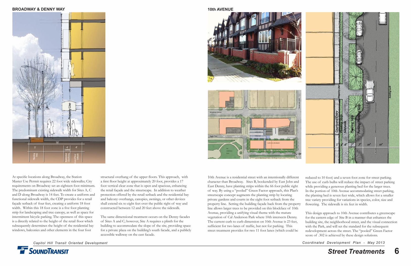
At specific locations along Broadway, the Station Master Use Permit requires 22 foot wide sidewalks; City requirements on Broadway set an eighteen foot minimum. The predominant existing sidewalk width for Sites A, C and D along Broadway is 14 feet. To create a uniform and functional sidewalk width, the CDP provides for a retail façade setback of four feet, creating a uniform 18 foot width. Within this 18 foot zone is a five foot planting strip for landscaping and tree canopy, as well as space for intermittent bicycle parking. The openness of this space is a directly related to the height of the retail floor which subsequently determines the height of the residential bay windows, balconies and other elements in the four foot
10th Avenue is a residential street with an intentionally different character than Broadway. Sites B, bookended by East John and East Denny, have planting strips within the 66 foot public right of way. By using a “pooled” Green Factor approach, this Plan’s streetscape concept augments the planting strip by locating private gardens and courts in the eight foot setback from the property line. Setting the building façade back from the property line allows larger trees to be provided on this blockface of 10th Avenue, providing a unifying visual theme with the mature vegetation of Cal Anderson Park where 10th intersects Denny. The current curb to curb dimension on 10th Avenue is 23 feet, sufficient for two lanes of traffic, but not for parking. This street treatment provides for two 11 foot lanes (which could be
structural overhang of the upper floors. This approach, with a first floor height at approximately 20 foot, provides a 17 foot vertical clear zone that is open and spacious, enhancing the retail façade and the streetscape. In addition to weather protection offered by the retail setback and the residential bay and balcony overhangs, canopies, awnings, or other devices shall extend six to eight feet over the public right of way and constructed between 12 and 20 feet above the sidewalk.
The same dimensional treatment occurs on the Denny facades of Sites A and C; however, Site A requires a plinth for the building to accommodate the slope of the site, providing space for a private plaza on the building’s south facade, and a publicly accessible walkway on the east facade.
reduced to 10 foot) and a seven foot zone for street parking. The use of curb bulbs will reduce the impact of street parking while providing a generous planting bed for the larger trees. In the portion of 10th Avenue accommodating street parking, the planting bed is seven feet wide, which allows for a smaller tree variety providing for variations in species, color, size and flowering. The sidewalk is six feet in width.
This design approach to 10th Avenue contributes a greenscape for the eastern edge of Site B in a manner that enhances the building site, the neighborhood street, and the visual connection with the Park, and will set the standard for the subsequent redevelopment across the street. The “pooled” Green Factor score of .302 is achieved by these design solutions.
10th AVENUEBROADWAY & DENNY WAY
N
Capitol Hill Transit Oriented Development Coordinated Development Plan - May 2013
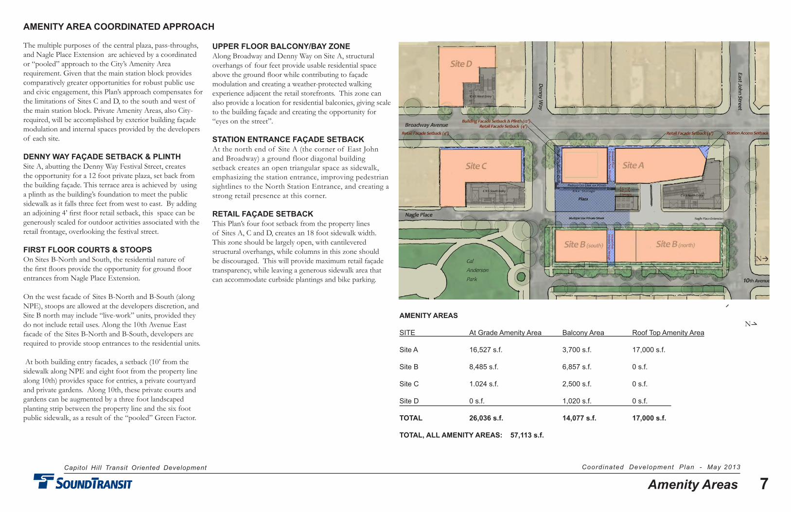
7Amenity Areas
The multiple purposes of the central plaza, pass-throughs, and Nagle Place Extension are achieved by a coordinated or “pooled” approach to the City’s Amenity Area requirement. Given that the main station block provides comparatively greater opportunities for robust public use and civic engagement, this Plan’s approach compensates for the limitations of Sites C and D, to the south and west of the main station block. Private Amenity Areas, also City-required, will be accomplished by exterior building façade modulation and internal spaces provided by the developers of each site.
DENNY WAY FAÇADE SETBACK & PLINTHSite A, abutting the Denny Way Festival Street, creates the opportunity for a 12 foot private plaza, set back from the building façade. This terrace area is achieved by using a plinth as the building’s foundation to meet the public sidewalk as it falls three feet from west to east. By adding an adjoining 4’ first floor retail setback, this space can be generously scaled for outdoor activities associated with the retail frontage, overlooking the festival street.
FIRST FLOOR COURTS & STOOPSOn Sites B-North and South, the residential nature of the first floors provide the opportunity for ground floor entrances from Nagle Place Extension.
On the west facade of Sites B-North and B-South (along NPE), stoops are allowed at the developers discretion, and Site B north may include “live-work” units, provided they do not include retail uses. Along the 10th Avenue East facade of the Sites B-North and B-South, developers are required to provide stoop entrances to the residential units.
At both building entry facades, a setback (10’ from the sidewalk along NPE and eight foot from the property line along 10th) provides space for entries, a private courtyard and private gardens. Along 10th, these private courts and gardens can be augmented by a three foot landscaped planting strip between the property line and the six foot public sidewalk, as a result of the “pooled” Green Factor.
UPPER FLOOR BALCONY/BAY ZONEAlong Broadway and Denny Way on Site A, structural overhangs of four feet provide usable residential space above the ground floor while contributing to façade modulation and creating a weather-protected walking experience adjacent the retail storefronts. This zone can also provide a location for residential balconies, giving scale to the building façade and creating the opportunity for “eyes on the street”.
STATION ENTRANCE FAÇADE SETBACKAt the north end of Site A (the corner of East John and Broadway) a ground floor diagonal building setback creates an open triangular space as sidewalk, emphasizing the station entrance, improving pedestrian sightlines to the North Station Entrance, and creating a strong retail presence at this corner.
RETAIL FAÇADE SETBACK This Plan’s four foot setback from the property lines of Sites A, C and D, creates an 18 foot sidewalk width. This zone should be largely open, with cantilevered structural overhangs, while columns in this zone should be discouraged. This will provide maximum retail façade transparency, while leaving a generous sidewalk area that can accommodate curbside plantings and bike parking.
AMENITY AREAS
SITE At Grade Amenity Area Balcony Area Roof Top Amenity Area
Site A 16,527 s.f. 3,700 s.f. 17,000 s.f. Site B 8,485 s.f. 6,857 s.f. 0 s.f.
Site C 1.024 s.f. 2,500 s.f. 0 s.f.
Site D 0 s.f. 1,020 s.f. 0 s.f.
TOTAL 26,036 s.f. 14,077 s.f. 17,000 s.f.
TOTAL, ALL AMENITY AREAS: 57,113 s.f.
AMENITY AREA COORDINATED APPROACH
N
N
Capitol Hill Transit Oriented Development Coordinated Development Plan - May 2013
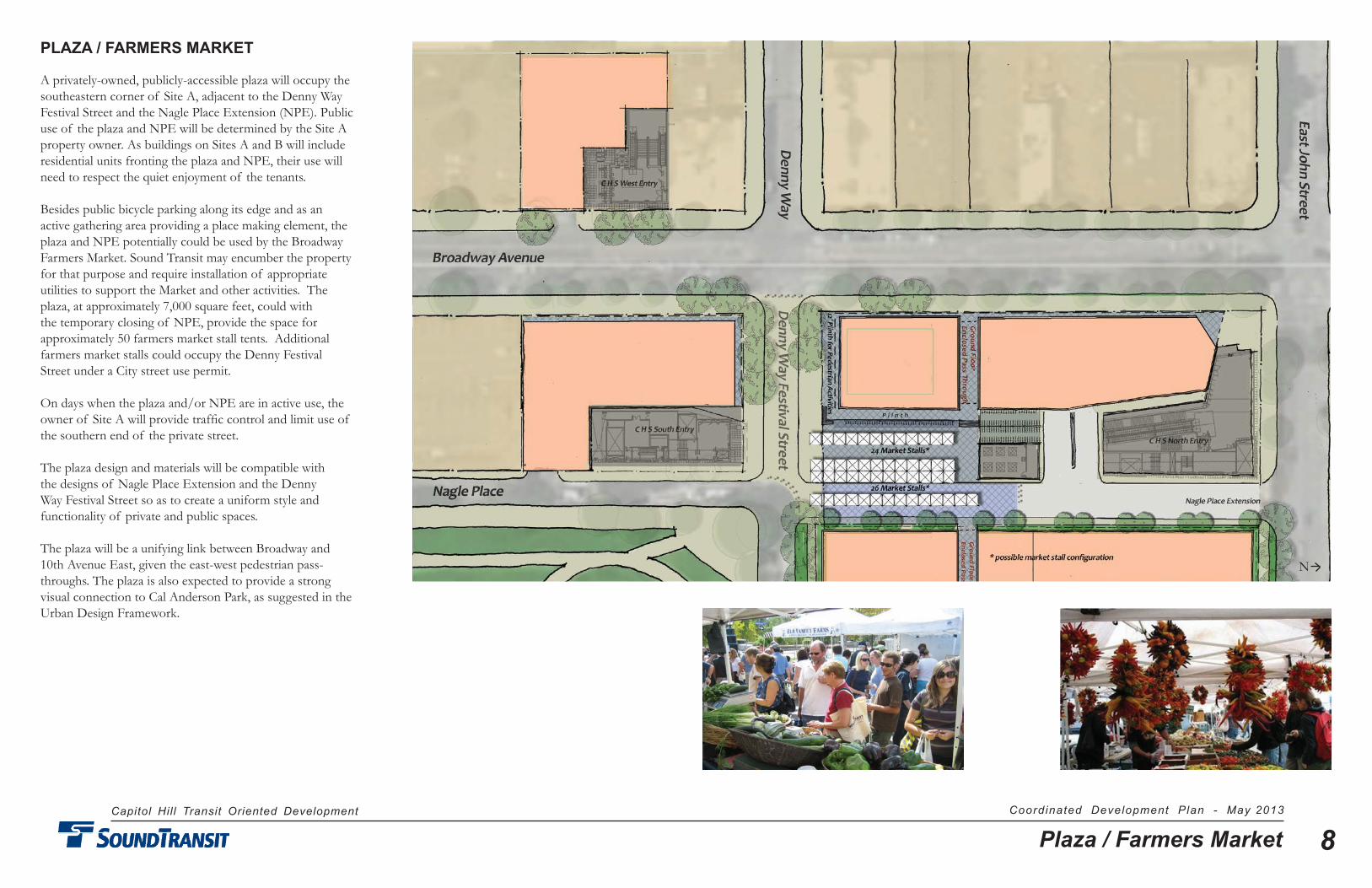
8Plaza / Farmers Market
PLAZA / FARMERS MARKET
A privately-owned, publicly-accessible plaza will occupy the southeastern corner of Site A, adjacent to the Denny Way Festival Street and the Nagle Place Extension (NPE). Public use of the plaza and NPE will be determined by the Site A property owner. As buildings on Sites A and B will include residential units fronting the plaza and NPE, their use will need to respect the quiet enjoyment of the tenants.
Besides public bicycle parking along its edge and as an active gathering area providing a place making element, the plaza and NPE potentially could be used by the Broadway Farmers Market. Sound Transit may encumber the property for that purpose and require installation of appropriate utilities to support the Market and other activities. The plaza, at approximately 7,000 square feet, could with the temporary closing of NPE, provide the space for approximately 50 farmers market stall tents. Additional farmers market stalls could occupy the Denny Festival Street under a City street use permit.
On days when the plaza and/or NPE are in active use, the owner of Site A will provide traffic control and limit use of the southern end of the private street.
The plaza design and materials will be compatible with the designs of Nagle Place Extension and the Denny Way Festival Street so as to create a uniform style and functionality of private and public spaces.
The plaza will be a unifying link between Broadway and 10th Avenue East, given the east-west pedestrian pass-throughs. The plaza is also expected to provide a strong visual connection to Cal Anderson Park, as suggested in the Urban Design Framework.
N
Capitol Hill Transit Oriented Development Coordinated Development Plan - May 2013
9Plaza Bike Parking
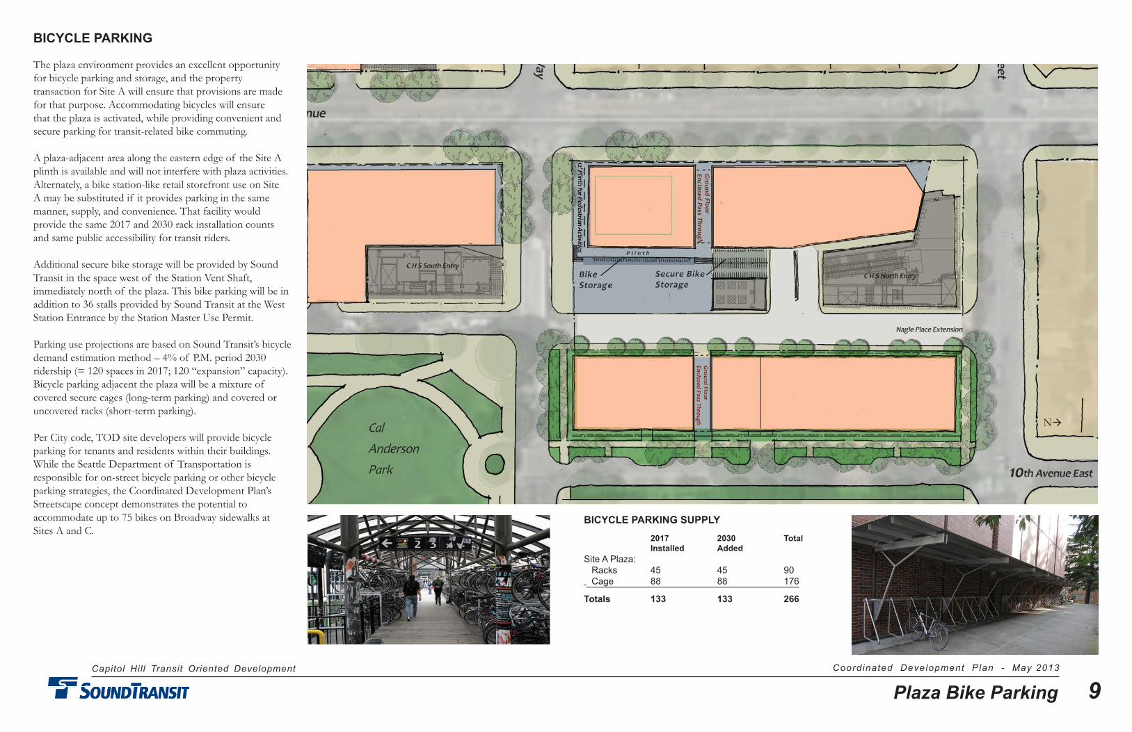
BICYCLE PARKING
The plaza environment provides an excellent opportunity for bicycle parking and storage, and the property transaction for Site A will ensure that provisions are made for that purpose. Accommodating bicycles will ensure that the plaza is activated, while providing convenient and secure parking for transit-related bike commuting.
A plaza-adjacent area along the eastern edge of the Site A plinth is available and will not interfere with plaza activities. Alternately, a bike station-like retail storefront use on Site A may be substituted if it provides parking in the same manner, supply, and convenience. That facility would provide the same 2017 and 2030 rack installation counts and same public accessibility for transit riders.
Additional secure bike storage will be provided by Sound Transit in the space west of the Station Vent Shaft, immediately north of the plaza. This bike parking will be in addition to 36 stalls provided by Sound Transit at the West Station Entrance by the Station Master Use Permit.
Parking use projections are based on Sound Transit’s bicycle demand estimation method – 4% of P.M. period 2030 ridership (= 120 spaces in 2017; 120 “expansion” capacity). Bicycle parking adjacent the plaza will be a mixture of covered secure cages (long-term parking) and covered or uncovered racks (short-term parking).
Per City code, TOD site developers will provide bicycle parking for tenants and residents within their buildings. While the Seattle Department of Transportation is responsible for on-street bicycle parking or other bicycle parking strategies, the Coordinated Development Plan’s Streetscape concept demonstrates the potential to accommodate up to 75 bikes on Broadway sidewalks at Sites A and C.
BICYCLE PARKING SUPPLY
2017 2030 Total Installed AddedSite A Plaza: Racks 45 45 90 Cage 88 88 176
Totals 133 133 266
N

Capitol Hill Transit Oriented Development Coordinated Development Plan - May 2013
10Pedestrian Passages & Plaza
PEDESTRIAN PASSAGES & PLAZA
PEDESTRIAN PASS-THROUGHSAs elements of the “pooled” Amenity Area approach, Sites A and B will have east-west enclosed pedestrian passages, connecting Broadway to the plaza, Nagle Place Extension, and 10th Avenue East. These passages are to be the full height of the ground floor-to-floor dimensions (15 - 20 feet), of similar width (15 - 20 feet), located approximately on axis with the Vent Shaft to allow a break in Broadway street façade. The west facade break will have provide an architectural feature to emphasize the pass-through. The passages will have publicly accessibility, but will be managed as private space, subject to compatible building uses, such as residential lobby access. At the discretion of the Site A developer, the pass-through may be open to the sky.
PEDESTRIAN PLINTHThe southern building facade of Site A will be set back 12 feet from the property line, providing a generous private space on the plinth adjacent and above the Festival Street. This provides a level surface for retail/restaurant frontage, while connecting to the pedestrian link on the east facade of the building.
PEDESTRIAN WAYThe pedestrian way along Site A’s eastern facade provides a connection from the building pass-through to the plaza and Denny Way. Due to the grade change along Denny Way, this pedestrian way on the plinth requires stairs from the plinth to the sidewalk and street, a three-foot change in grade.
N
Capitol Hill Transit Oriented Development Coordinated Development Plan - May 2013
11Green Factor
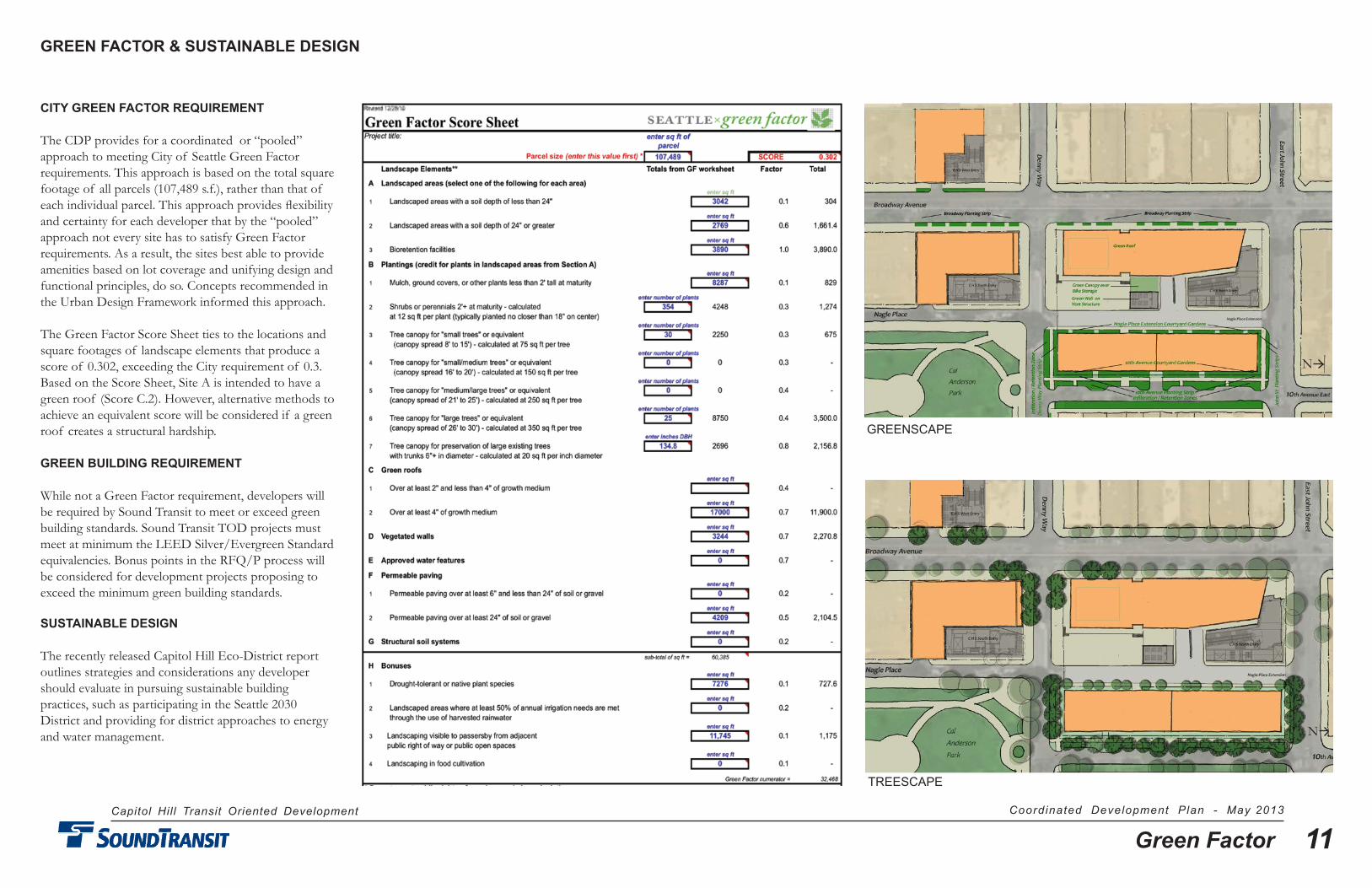
CITY GREEN FACTOR REqUIREMENT
The CDP provides for a coordinated or “pooled” approach to meeting City of Seattle Green Factor requirements. This approach is based on the total square footage of all parcels (107,489 s.f.), rather than that of each individual parcel. This approach provides flexibility and certainty for each developer that by the “pooled” approach not every site has to satisfy Green Factor requirements. As a result, the sites best able to provide amenities based on lot coverage and unifying design and functional principles, do so. Concepts recommended in the Urban Design Framework informed this approach.
The Green Factor Score Sheet ties to the locations and square footages of landscape elements that produce a score of 0.302, exceeding the City requirement of 0.3. Based on the Score Sheet, Site A is intended to have a green roof (Score C.2). However, alternative methods to achieve an equivalent score will be considered if a green roof creates a structural hardship.
GREEN BUILDING REqUIREMENT
While not a Green Factor requirement, developers will be required by Sound Transit to meet or exceed green building standards. Sound Transit TOD projects must meet at minimum the LEED Silver/Evergreen Standard equivalencies. Bonus points in the RFQ/P process will be considered for development projects proposing to exceed the minimum green building standards.
SUSTAINABLE DESIGN
The recently released Capitol Hill Eco-District report outlines strategies and considerations any developer should evaluate in pursuing sustainable building practices, such as participating in the Seattle 2030 District and providing for district approaches to energy and water management.
GREEN FACTOR & SUSTAINABLE DESIGN
GREENSCAPE
TREESCAPE
N
N
Capitol Hill Transit Oriented Development Coordinated Development Plan - May 2013
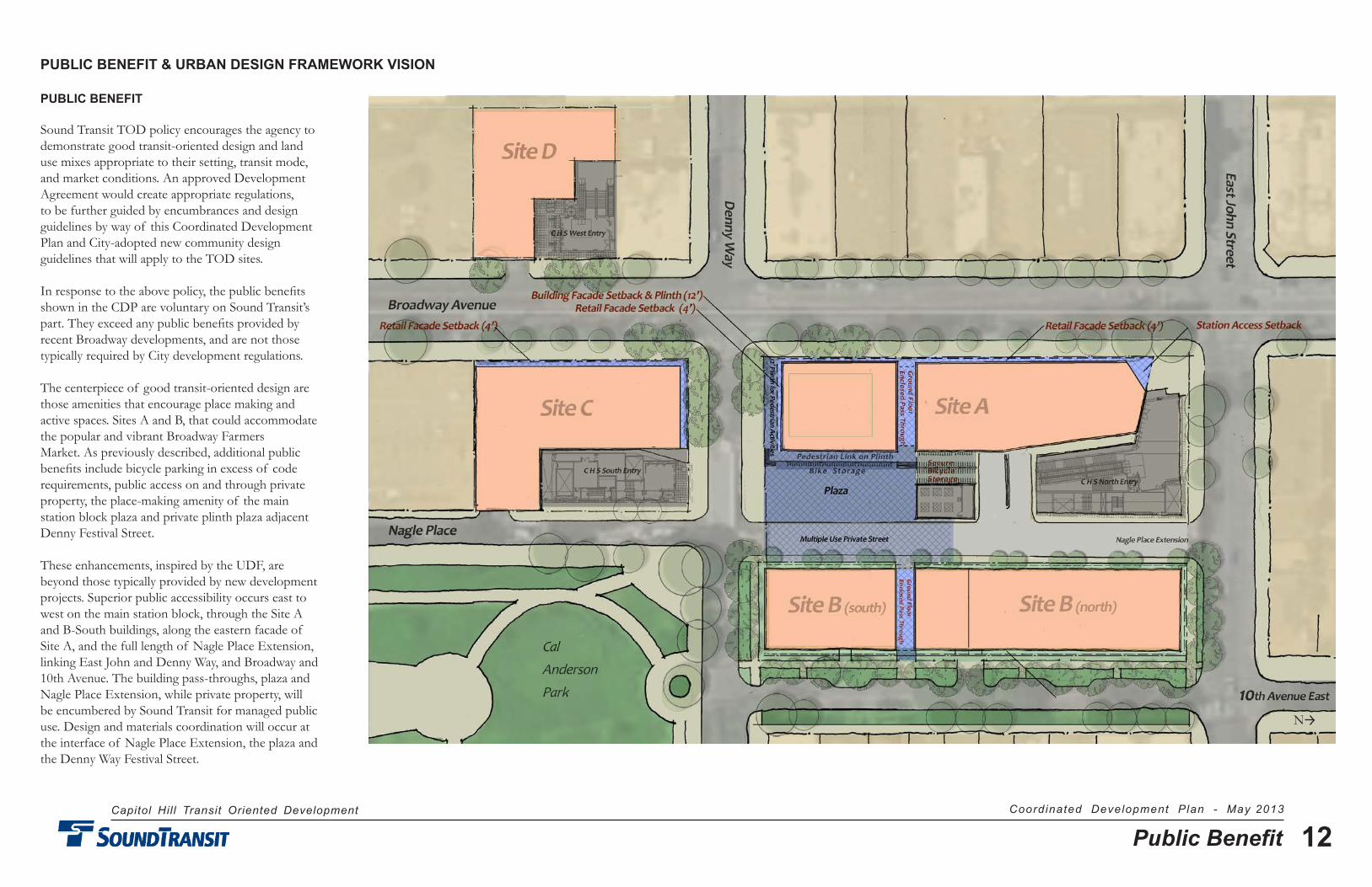
12Public Benefit
PUBLIC BENEFIT
Sound Transit TOD policy encourages the agency to demonstrate good transit-oriented design and land use mixes appropriate to their setting, transit mode, and market conditions. An approved Development Agreement would create appropriate regulations, to be further guided by encumbrances and design guidelines by way of this Coordinated Development Plan and City-adopted new community design guidelines that will apply to the TOD sites.
In response to the above policy, the public benefits shown in the CDP are voluntary on Sound Transit’s part. They exceed any public benefits provided by recent Broadway developments, and are not those typically required by City development regulations.
The centerpiece of good transit-oriented design are those amenities that encourage place making and active spaces. Sites A and B, that could accommodate the popular and vibrant Broadway Farmers Market. As previously described, additional public benefits include bicycle parking in excess of code requirements, public access on and through private property, the place-making amenity of the main station block plaza and private plinth plaza adjacent Denny Festival Street.
These enhancements, inspired by the UDF, are beyond those typically provided by new development projects. Superior public accessibility occurs east to west on the main station block, through the Site A and B-South buildings, along the eastern facade of Site A, and the full length of Nagle Place Extension, linking East John and Denny Way, and Broadway and 10th Avenue. The building pass-throughs, plaza and Nagle Place Extension, while private property, will be encumbered by Sound Transit for managed public use. Design and materials coordination will occur at the interface of Nagle Place Extension, the plaza and the Denny Way Festival Street.
PUBLIC BENEFIT & URBAN DESIGN FRAMEWORK VISION
N
Capitol Hill Transit Oriented Development Coordinated Development Plan - May 2013
13Urban Design Framework
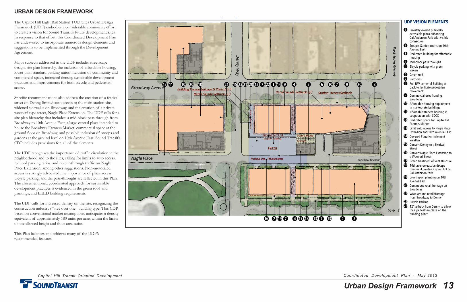
URBAN DESIGN FRAMEWORK
The Capitol Hill Light Rail Station TOD Sites Urban Design Framework (UDF) embodies a considerable community effort to create a vision for Sound Transit’s future development sites. In response to that effort, this Coordinated Development Plan has endeavored to incorporate numerous design elements and suggestions to be implemented through the Development Agreement.
Major subjects addressed in the UDF include: streetscape design, site plan hierarchy, the inclusion of affordable housing, lower than standard parking ratios, inclusion of community and commercial space, increased density, sustainable development practices and improvements for both bicycle and pedestrian access.
Specific recommendations also address the creation of a festival street on Denny, limited auto access to the main station site, widened sidewalks on Broadway, and the creation of a private woonerf-type street, Nagle Place Extension. The UDF calls for a site plan hierarchy that includes: a mid-block pass through from Broadway to 10th Avenue East, a large central plaza intended to house the Broadway Farmers Market, commercial space at the ground floor on Broadway, and possible inclusion of stoops and gardens at the ground level on 10th Avenue East. Sound Transit’s CDP includes provisions for all of the elements.
The UDF recognizes the importance of traffic circulation in the neighborhood and to the sites, calling for limits to auto access, reduced parking ratios, and no cut-through traffic on Nagle Place Extension, among other suggestions. Non-motorized access is strongly advocated; the importance of plaza access, bicycle parking, and the pass-throughs are reflected in this Plan. The aforementioned coordinated approach for sustainable development practices is evidenced in the green roof and plantings, and LEED building requirements.
The UDF calls for increased density on the site, recognizing the construction industry’s “five over one” building type. This CDP, based on conventional market assumptions, anticipates a density equivalent of approximately 180 units per acre, within the limits of the allowed height and floor area ratios.
This Plan balances and achieves many of the UDF’s recommended features.
N

Capitol Hill Transit Oriented Development Coordinated Development Plan - May 2013
14Vehicular Access
VEHICULAR CIRCULATION PLAN
This Plan provides a coordinated approach to vehicular traffic circulation, ensuring adequate site access and egress for vehicles, while minimizing conflicts with other modes of travel. This is important in the dense urban neighborhood setting of the Capitol Hill Station where there will be a combined substantial increase in transit service (regional light rail and local street car), and in the context of the needs of existing vehicular traffic.
Compared with the former built environment, the new development will create greater demands on the existing street system and its functionality due to a substantial increase in density. Also affecting this neighborhood circulation will be the East Denny Way Festival Street, altering use as an east-west neighborhood connection. The addition of the street car on Broadway, with curb parking eliminated will be major changes. The additional residential tenants and vehicles associated with redevelopment, along with the City’s streetscape changes to Broadway, will occur in an environment changed by years of light rail and street car construction.
Even with these changes, Sound Transit’s 2011 traffic analysis for the TOD sites and immediate neighborhood indicated no significant impact based on the planned development. New travel circumstances and patterns will occur with the completion of the station, the subsequent development, and new transit service.
The coordinated vehicular circulation plan provides for these changes, while protecting the integrity of the neighborhood and enhancing the amenity-creating elements of the new development, including the main station block plaza, Nagle Place Extension (NPE), and the Denny Festival Street. The circulation plan, worked out through negotiations leading to the Development Agreement, indicates how the traffic patterns in the vicinity of the sites will function. Ensuring accessibility to NPE is fundamental to the success of the new main station block development and in reducing impacts on the neighborhood. NPE is necessary for Site A and B resident access and service requirements including Sound Transit Facilities service parking (see hatched area), as well as for the potential of the farmers market and other plaza uses. NPE will not function as a “cut-through” street between Denny and John Street.
Sound Transit will retain access to its facilities for planned and emergency maintenance via the plaza and NPE. As allowed by the approved station MUP, agency parking will be provided adjacent the eastern wall of the North headhouse (hatched area).
Implementing the coordinated circulation plan ensures neighborhood vehicular accessibility that contributes to an overall sense of place, functionality and development continuity.
N
Capitol Hill Transit Oriented Development Coordinated Development Plan - May 2013
15Garage Access
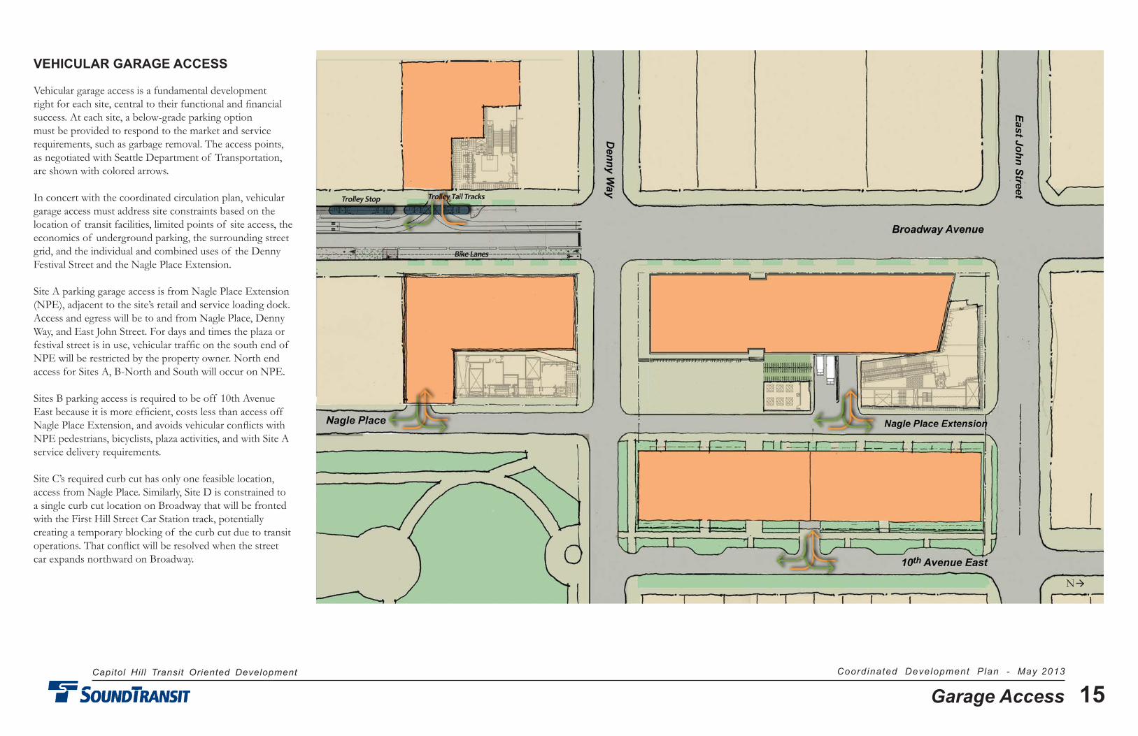
VEHICULAR GARAGE ACCESS
Vehicular garage access is a fundamental development right for each site, central to their functional and financial success. At each site, a below-grade parking option must be provided to respond to the market and service requirements, such as garbage removal. The access points, as negotiated with Seattle Department of Transportation, are shown with colored arrows.
In concert with the coordinated circulation plan, vehicular garage access must address site constraints based on the location of transit facilities, limited points of site access, the economics of underground parking, the surrounding street grid, and the individual and combined uses of the Denny Festival Street and the Nagle Place Extension.
Site A parking garage access is from Nagle Place Extension (NPE), adjacent to the site’s retail and service loading dock. Access and egress will be to and from Nagle Place, Denny Way, and East John Street. For days and times the plaza or festival street is in use, vehicular traffic on the south end of NPE will be restricted by the property owner. North end access for Sites A, B-North and South will occur on NPE.
Sites B parking access is required to be off 10th Avenue East because it is more efficient, costs less than access off Nagle Place Extension, and avoids vehicular conflicts with NPE pedestrians, bicyclists, plaza activities, and with Site A service delivery requirements.
Site C’s required curb cut has only one feasible location, access from Nagle Place. Similarly, Site D is constrained to a single curb cut location on Broadway that will be fronted with the First Hill Street Car Station track, potentially creating a temporary blocking of the curb cut due to transit operations. That conflict will be resolved when the street car expands northward on Broadway.
N
Capitol Hill Transit Oriented Development Coordinated Development Plan - May 2013
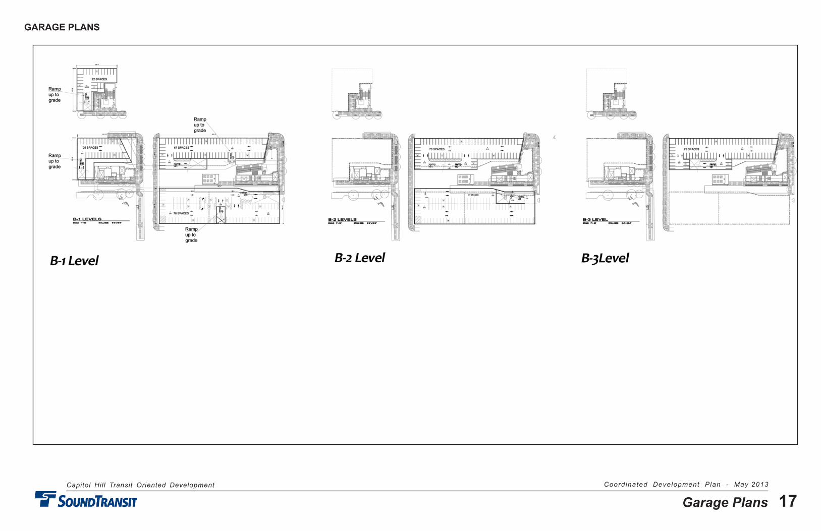
16Garage Plans
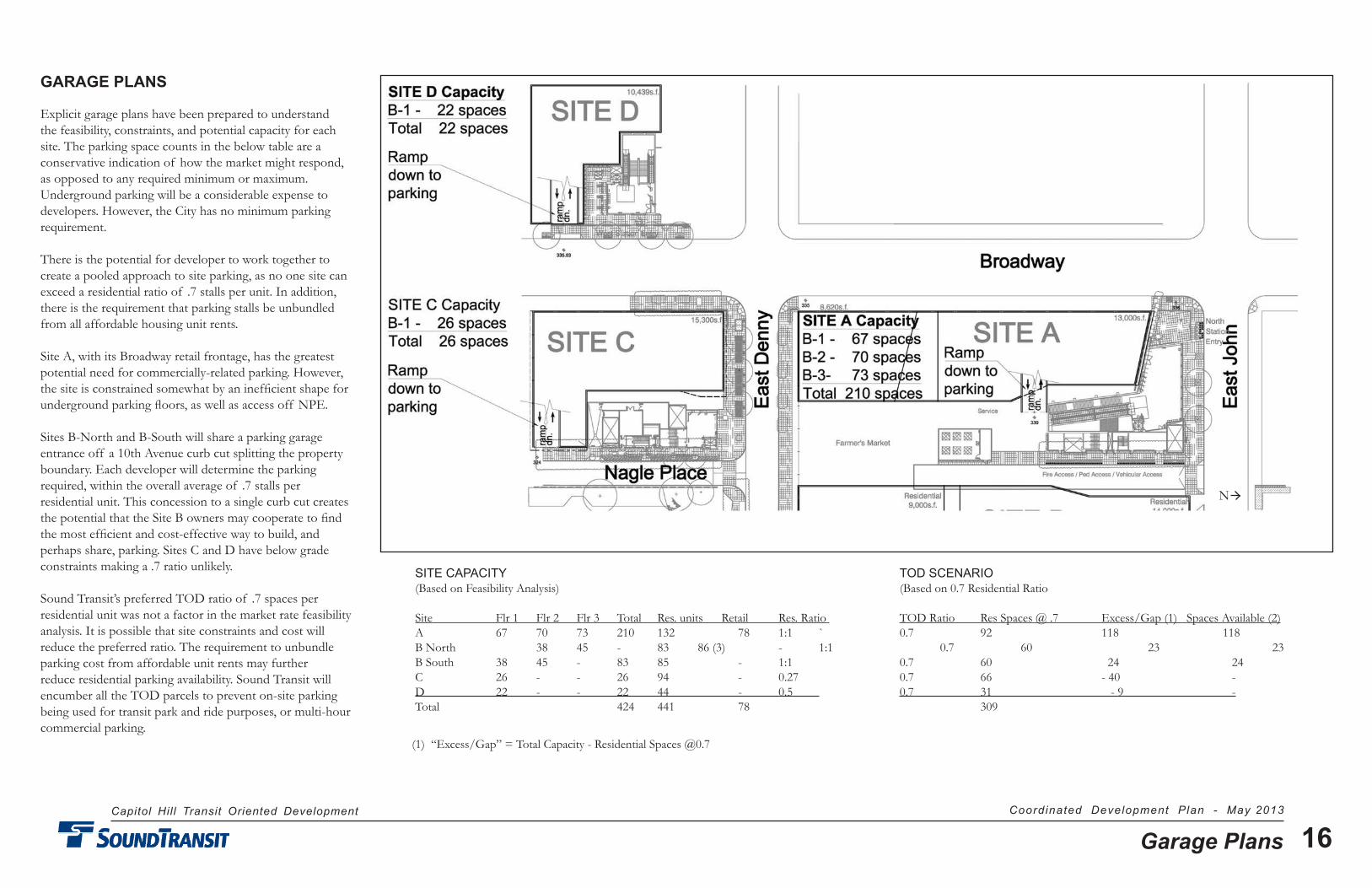
GARAGE PLANS
Explicit garage plans have been prepared to understand the feasibility, constraints, and potential capacity for each site. The parking space counts in the below table are a conservative indication of how the market might respond, as opposed to any required minimum or maximum. Underground parking will be a considerable expense to developers. However, the City has no minimum parking requirement.
There is the potential for developer to work together to create a pooled approach to site parking, as no one site can exceed a residential ratio of .7 stalls per unit. In addition, there is the requirement that parking stalls be unbundled from all affordable housing unit rents.
Site A, with its Broadway retail frontage, has the greatest potential need for commercially-related parking. However, the site is constrained somewhat by an inefficient shape for underground parking floors, as well as access off NPE.
Sites B-North and B-South will share a parking garage entrance off a 10th Avenue curb cut splitting the property boundary. Each developer will determine the parking required, within the overall average of .7 stalls per residential unit. This concession to a single curb cut creates the potential that the Site B owners may cooperate to find the most efficient and cost-effective way to build, and perhaps share, parking. Sites C and D have below grade constraints making a .7 ratio unlikely.
Sound Transit’s preferred TOD ratio of .7 spaces per residential unit was not a factor in the market rate feasibility analysis. It is possible that site constraints and cost will reduce the preferred ratio. The requirement to unbundle parking cost from affordable unit rents may further reduce residential parking availability. Sound Transit will encumber all the TOD parcels to prevent on-site parking being used for transit park and ride purposes, or multi-hour commercial parking.
SITE CAPACITY TOD SCENARIO (Based on Feasibility Analysis) (Based on 0.7 Residential Ratio
Site Flr 1 Flr 2 Flr 3 Total Res. units Retail Res. Ratio TOD Ratio Res Spaces @ .7 Excess/Gap (1) Spaces Available (2) A 67 70 73 210 132 78 1:1 ` 0.7 92 118 118 B North 38 45 - 83 86 (3) - 1:1 0.7 60 23 23 B South 38 45 - 83 85 - 1:1 0.7 60 24 24 C 26 - - 26 94 - 0.27 0.7 66 - 40 - D 22 - - 22 44 - 0.5 0.7 31 - 9 - Total 424 441 78 309
(1) “Excess/Gap” = Total Capacity - Residential Spaces @0.7
N
Capitol Hill Transit Oriented Development Coordinated Development Plan - May 2013
17Garage Plans
GARAGE PLANS