California's Maritime Heritage
29
1 California’s Maritime Heritage: Defining It Through History and Analyzing It Through The Law By: Janelle Harrison
-
Upload
janellee73 -
Category
Documents
-
view
220 -
download
0
Transcript of California's Maritime Heritage
8/6/2019 California's Maritime Heritage
http://slidepdf.com/reader/full/californias-maritime-heritage 1/29
1
California’s Maritime Heritage:Defining It Through History and Analyzing It Through
The Law
By: Janelle Harrison
8/6/2019 California's Maritime Heritage
http://slidepdf.com/reader/full/californias-maritime-heritage 2/29
2
Table Of Contents
Introduction ...........................................................................................................1
Geography of California’s Maritime Heritage………………………………………...1
California's Prehistory…………………………………………………………………..3
Spanish Legacy 15th & 16th Centuries………………………………………………..4
Managing California’s Underwater Cultural Resources.......................................16
Local................................................................................................................20
State................................................................................................................20
Federal............................................................................................................20
International.....................................................................................................20
California State Lands Commission.............................................................21
California State Parks ..................................................................................21
What This All Means...........................................................................................25
8/6/2019 California's Maritime Heritage
http://slidepdf.com/reader/full/californias-maritime-heritage 3/29
3
Table of Figures
Fig 1 Map of Southern California and Channel Islands…………………..2
Fig 2 Maris Pacifici, circa 1592………………………………………...……5
Fig 3 Map of Gulf Of The Farallones………………………………………..6
Fig 4 Lithograph of vessel Winfield Scott …………………………..……....7
Fig 5 Wreck Details of Winfield Scott ……………………………………….9
Fig 6 Historic Map of Anacapa Island, 1856……………………………….9
Fig 7 Historical Atlas Map of Panama Canal, W. Shepard 1923…..…...10
Fig 8 Wreck Details of Aggi…………………………………………………11
Fig 9 Map: California State Marine Protected Areas……………………..14
Fig 10 Photo of the Balclutha……………………………………………….19
8/6/2019 California's Maritime Heritage
http://slidepdf.com/reader/full/californias-maritime-heritage 4/29
4
List of Acronyms and Abbreviations
CINP: Channel Islands National Park
CINMS: Channel Islands National Marine Sanctuary
CMAR: Coastal Maritime Archaeology Resources
CRM: Cultural Resource Management
CSLC: California State Lands Commission
CSMPA: California State Marine Protected Areas
MMS: Minerals Management Service
NMSP: National Marine Sanctuary Program
NOAA: National Oceanographic and Atmospheric Administration’s
NPS: National Parks Service
SAC: Sanctuary Advisory Council
SHPO: State Historic Preservation Office
SFMNHP: San Francisco Maritime National Historical Park
UNCLOS: United Nations Convention of Law of the Sea
UNESCO: United Nations Educational, Scientific and Cultural Organization
8/6/2019 California's Maritime Heritage
http://slidepdf.com/reader/full/californias-maritime-heritage 5/29
5
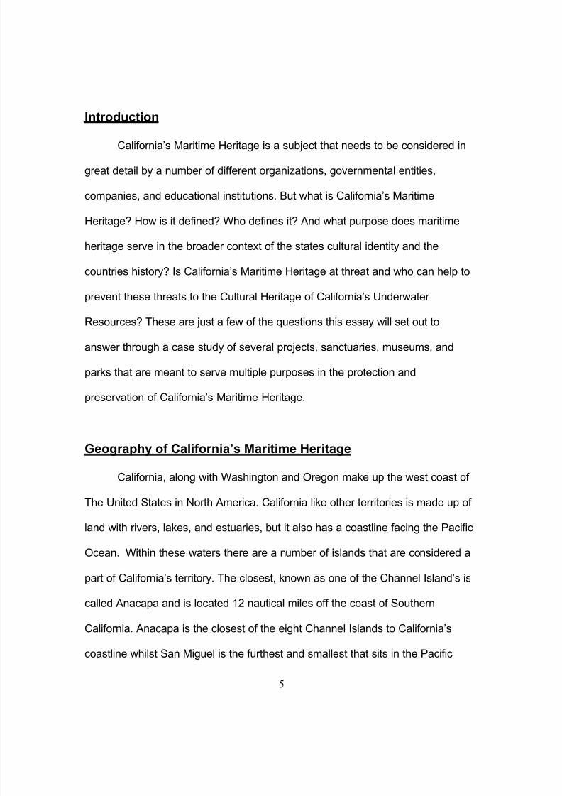
Introduction
California’s Maritime Heritage is a subject that needs to be considered in
great detail by a number of different organizations, governmental entities,
companies, and educational institutions. But what is California’s Maritime
Heritage? How is it defined? Who defines it? And what purpose does maritime
heritage serve in the broader context of the states cultural identity and the
countries history? Is California’s Maritime Heritage at threat and who can help to
prevent these threats to the Cultural Heritage of California’s Underwater
Resources? These are just a few of the questions this essay will set out to
answer through a case study of several projects, sanctuaries, museums, and
parks that are meant to serve multiple purposes in the protection and
preservation of California’s Maritime Heritage.
Geography of California’s Maritime Heritage
California, along with Washington and Oregon make up the west coast of
The United States in North America. California like other territories is made up of
land with rivers, lakes, and estuaries, but it also has a coastline facing the Pacific
Ocean. Within these waters there are a number of islands that are considered a
part of California’s territory. The closest, known as one of the Channel Island’s is
called Anacapa and is located 12 nautical miles off the coast of Southern
California. Anacapa is the closest of the eight Channel Islands to California’s
coastline whilst San Miguel is the furthest and smallest that sits in the Pacific
8/6/2019 California's Maritime Heritage
http://slidepdf.com/reader/full/californias-maritime-heritage 6/29
6
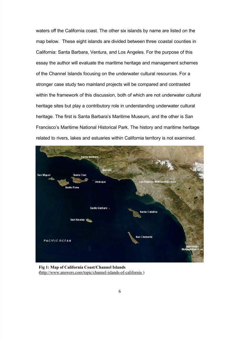
waters off the California coast. The other six islands by name are listed on the
map below. These eight islands are divided between three coastal counties in
California: Santa Barbara, Ventura, and Los Angeles. For the purpose of this
essay the author will evaluate the maritime heritage and management schemes
of the Channel Islands focusing on the underwater cultural resources. For a
stronger case study two mainland projects will be compared and contrasted
within the framework of this discussion, both of which are not underwater cultural
heritage sites but play a contributory role in understanding underwater cultural
heritage. The first is Santa Barbara’s Maritime Museum, and the other is San
Francisco’s Maritime National Historical Park. The history and maritime heritage
related to rivers, lakes and estuaries within California territory is not examined.
Fig 1: Map of California Coast/Channel Islands
(http://www.answers.com/topic/channel-islands-of-california )
8/6/2019 California's Maritime Heritage
http://slidepdf.com/reader/full/californias-maritime-heritage 7/29
7
California’s Prehistory
To understand California’s Maritime Cultural Heritage in it’s broadest
context we can begin by looking at the study of the archaeological evidence on
land which creates a record for human occupation on the coast of California that
dates to “circa 9,000 years before the present (B.P.)” (California State Lands
Commission 2006, 4.9-1). According to the California State Lands Commission
the Ventura County region can be divided into three periods, which cover the
prehistory of California. The late period, which dates circa 800 to 150 B.P. is of
particular importance to California’s Cultural Maritime Heritage and Resources
because this period marks the emergence of the Chumash Indian culture (CSLC
2006, 4.9-2). The Chumash Indian society lived along the coast of California as
far north as San Luis Obispo down to Malibu, but even more amazingly they also
occupied the Islands of San Miguel, Santa Rosa, Santa Cruz, and Anacapa.
They used their maritime technological skills to build planked wood canoes that
carried them to the Channel Islands (CSLC 2006, 4.9-2).
The Santa Barbara Maritime Museum currently houses and exhibition
based on the Chumash maritime practices and culture. Those persons were
California’s original seafarers. The exhibition has on display a 23-foot hand-made
wooden tomol, the same type of canoe that was built by the Chumash Indians
that used this watercraft to cross the Santa Barbara Channel to reach the
Channel Islands (http://www.sbmm.org/exhibitsmainfloor.php#chumash). The
museum also has on display replica tools that were used by the Chumash
Indians in food gathering from the sea. These replica items include such tools
8/6/2019 California's Maritime Heritage
http://slidepdf.com/reader/full/californias-maritime-heritage 8/29

8/6/2019 California's Maritime Heritage
http://slidepdf.com/reader/full/californias-maritime-heritage 9/29
9
doing has contributed to the maritime history and possibly the underwater cultural
heritage of the California.
(http://www.mms.gov/omm/pacific/kids/manilagalleons.htm).
According to the historical record, in 1594 the Spanish Galleon San
Augustin, was journeying form the Philippines along the California coast on this
route and stopped in a bay near San Francisco where she sank in a violent
storm. The MMS, part of the U.S. Department of interior (2006) purports that the
San Augustin is the first known shipwreck for California and The National Park
Service is diligently searching for her remains as part of California’s Underwater
Cultural Heritage (http://www.mms.gov/omm/pacific/kids/manilagalleons.htm).
This area, now known as Drake’s Bay is part of The National Parks Service, and
they have created a reserve. But this area is also recognized for another other
Fig 2: Maris Pacifici , circa 1592 (http://www.imagesonline.bl.uk/britishlibrary/controller/subjectidsearch?id=995&
startid=4500&width=4&height=2&idx=2)

8/6/2019 California's Maritime Heritage
http://slidepdf.com/reader/full/californias-maritime-heritage 10/29
10
famous visitor that circumnavigated the world, and it is named after him: Sir
Francis Drake (Chartoff and Chartoff 1984, 389). Below is a map that the Drake
Navigators Guild produced to support the theory that Drake Landed in this area
of California, since it has been purported that he actually landed at Goleta beach
near Santa Barbara. The Guild used evidence from the publication World
Encompassed, by Sir Francis Drake (Raymond 1978, 17).
Fig 3: Map of Gulf of The Farallones (Raymond
1978, 18)
8/6/2019 California's Maritime Heritage
http://slidepdf.com/reader/full/californias-maritime-heritage 11/29
11
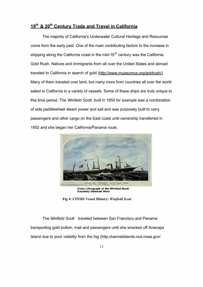
19th & 20th Century Trade and Travel in California
The majority of California’s Underwater Cultural Heritage and Resources
come form the early past. One of the main contributing factors to the increase in
shipping along the California coast in the mid-19th century was the California
Gold Rush. Natives and Immigrants from all over the United States and abroad
traveled to California in search of gold (http://www.museumca.org/goldrush/).
Many of them traveled over land, but many more from countries all over the world
sailed to California in a variety of vessels. Some of these ships are truly unique to
this time period. The Winfield Scott, built in 1850 for example was a combination
of side paddlewheel steam power and sail and was purposely built to carry
passengers and other cargo on the East coast until ownership transferred in
1852 and she began her California/Panama route.
The Winfield Scott traveled between San Francisco and Panama
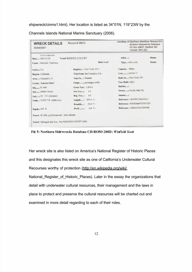
transporting gold bullion, mail and passengers until she wrecked off Anacapa
Island due to poor visibility from the fog (http:channelislands.nos.noaa.gov/
Fig 4: CINMS Vessel History: Winfield Scott
8/6/2019 California's Maritime Heritage
http://slidepdf.com/reader/full/californias-maritime-heritage 12/29
12
shipwreck/cinms1.html). Her location is listed as 34°01N, 119°23W by the
Channels Islands National Marine Sanctuary (2006).
Her wreck site is also listed on America’s National Register of Historic Places
and this designates this wreck site as one of California’s Underwater Cultural
Recourses worthy of protection (http://en.wikipedia.org/wiki/
National_Register_of_Historic_Places). Later in the essay the organizations that
detail with underwater cultural resources, their management and the laws in
place to protect and preserve the cultural resources will be charted out and
examined in more detail regarding to each of their roles.
Fi 5: Northern Shi wrecks Database CD-ROM 2002 : Win ield Scott
8/6/2019 California's Maritime Heritage
http://slidepdf.com/reader/full/californias-maritime-heritage 13/29
13
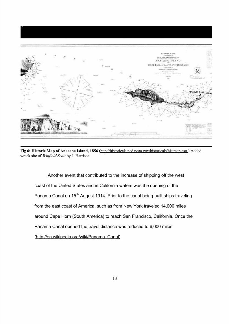
Another event that contributed to the increase of shipping off the west
coast of the United States and in California waters was the opening of the
Panama Canal on 15th August 1914. Prior to the canal being built ships traveling
from the east coast of America, such as from New York traveled 14,000 miles
around Cape Horn (South America) to reach San Francisco, California. Once the
Panama Canal opened the travel distance was reduced to 6,000 miles
(http://en.wikipedia.org/wiki/Panama_Canal).
Fig 6: Historic Map of Anacapa Island, 1856 (http://historicals.ncd.noaa.gov/historicals/histmap.asp ) Added
wreck site of Winfield Scott by J. Harrison
8/6/2019 California's Maritime Heritage
http://slidepdf.com/reader/full/californias-maritime-heritage 14/29
14
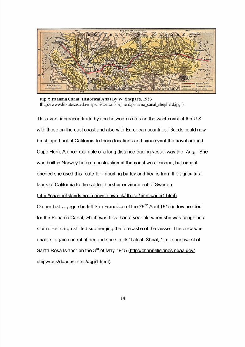
This event increased trade by sea between states on the west coast of the U.S.
with those on the east coast and also with European countries. Goods could now
be shipped out of California to these locations and circumvent the travel around
Cape Horn. A good example of a long distance trading vessel was the Aggi. She
was built in Norway before construction of the canal was finished, but once it
opened she used this route for importing barley and beans from the agricultural
lands of California to the colder, harsher environment of Sweden
(http://channelislands.noaa.gov/shipwreck/dbase/cinms/aggi1.html).
On her last voyage she left San Francisco of the 29 th April 1915 in tow headed
for the Panama Canal, which was less than a year old when she was caught in a
storm. Her cargo shifted submerging the forecastle of the vessel. The crew was
unable to gain control of her and she struck “Talcott Shoal, 1 mile northwest of
Santa Rosa Island” on the 3rd of May 1915 (http://channelislands.noaa.gov/
shipwreck/dbase/cinms/aggi1.html).
Fig 7: Panama Canal: Historical Atlas By W. Shepard, 1923
(http://www.lib.utexas.edu/maps/historical/shepherd/panama_canal_shepherd.jpg )
8/6/2019 California's Maritime Heritage
http://slidepdf.com/reader/full/californias-maritime-heritage 15/29
15
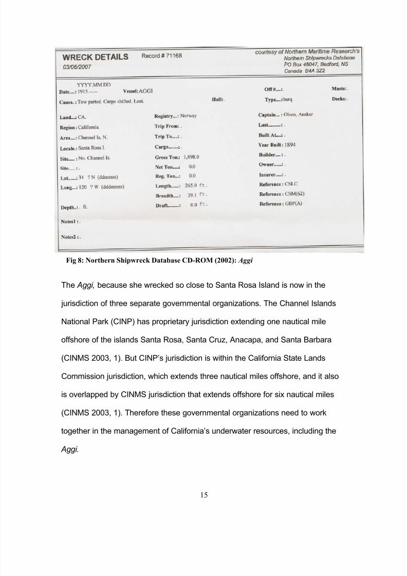
The Aggi, because she wrecked so close to Santa Rosa Island is now in the
jurisdiction of three separate governmental organizations. The Channel Islands
National Park (CINP) has proprietary jurisdiction extending one nautical mile
offshore of the islands Santa Rosa, Santa Cruz, Anacapa, and Santa Barbara
(CINMS 2003, 1). But CINP’s jurisdiction is within the California State Lands
Commission jurisdiction, which extends three nautical miles offshore, and it also
is overlapped by CINMS jurisdiction that extends offshore for six nautical miles
(CINMS 2003, 1). Therefore these governmental organizations need to work
together in the management of California’s underwater resources, including the
Aggi.
Fig 8: Northern Shipwreck Database CD-ROM (2002): Aggi

8/6/2019 California's Maritime Heritage
http://slidepdf.com/reader/full/californias-maritime-heritage 16/29
16
Managing California’s Underwater Cultural Resources
The Secretary of Commerce designated the National Marine Sanctuary
Program (NMSP) for California, and the leading agency for implementing this
program is NOAA, a branch of the U.S. Department of Commerce. The Channel
Islands National Marine Sanctuary was designated in 1980, and is administered
by NOAA (CINMS 2006, i). These are the federal governing bodies that
implement laws and regulations regarding the offshore waters of the Channel
Islands, Richardson Rock, and Castle Rock within the six nautical mile
jurisdiction that this area, which is also a Sanctuary. The National Park Service
(NSP) also has jurisdiction up to one nautical mile offshore of four of the Channel
Islands: Santa Rosa, Santa Cruz, Anacapa, and Santa Barbara. There
jurisdictional area is considered a Park. The Channel Islands National Park’s
(CINP) service and CINMS share in the management and protection as well as
the enforcement, education, outreach, research, and monitoring of the Sanctuary
and Park.
Because these Islands are also considered the sovereign lands of the
State of California, the California State Lands Commission pursuant to section
6301 of the California Public Resource Code also manages and protects these
coastlines out to three nautical miles (CINMS 2006, i). According to CINMS, the
CSLC’s policies toward management of the state’s natural underwater resources
are based on the highest standards of “environmental protection, and financial
responsibility” to “preserve the public’s land for the use and enjoyment of future
generations”.
8/6/2019 California's Maritime Heritage
http://slidepdf.com/reader/full/californias-maritime-heritage 17/29
17
The above listed authorities strive for the same objectives under that
National Marine Sanctuaries Act, which is to “protect all natural and historical
resources of [the] national marine sanctuaries (CINMS 2006, 1).
The mission of the NMSP “is to identify, designate and manage areas of the marine environment of special national, and in some casesinternational, significance due to their conservation, recreational,ecological, historical, research, educational, or aesthetic qualities.” (15CFR 922.2(a)) Per the NMSA, the NMSP strives to improve theconservation and management of marine resources and seeks to“maintain for future generations the habitat, and ecological services, of the natural assemblage of living resources that inhabit these areas” (16U.S.C.1431 (a)(4)(C)). This statutory finding guides the NMSP to a broadand comprehensive management approach consistent with NMSA’sprimary objective of resource protection. The focus of such an approach
is broad-scale, ecosystem-level protection and management, unique fromthe various agencies and laws directed at managing single or limitednumbers of species or specific human activities within the ocean (CINMS2006, 1).
These authorities also function under Section 106 of the National Historic
Preservation Act. In order to better protect these shipwreck sites, the Channel
Islands National Marine Sanctuary, Channel Islands National Park, and the
California State Lands Commission have designated four of these shipwreck
sites for The National Register For Historic Places. According to CINMS (2003,
4) the Aggi, Cuba, Goldenhorn, and Winfield Scott are listed as historic
shipwreck properties. For any shipwreck to qualify for the National Register For
Historical Places it must have “the quality of significance in American history,
architecture, archeology, engineering, and culture… and [be] objects that
possess integrity of location, design, setting, materials, workmanship, feeling,
and association…and (A) that are associated with events that have made a
significant contribution to the broad patterns of our history; or (B) that are
associated with the lives of persons

8/6/2019 California's Maritime Heritage
http://slidepdf.com/reader/full/californias-maritime-heritage 18/29
18
significant in our past; or (C) that embody the distinctive characteristics of a type,
period, or method of construction, or that represent the work of a master, or that
possess high artistic values, or that represent a significant and distinguishable
entity whose components may lack individual distinction
(NPS: http://www.cr.nps.gov/nr/regulations.htm#605). “
In addition to the State and Federal organizations that manage and
enforce these laws, there are organizations such as the Coastal Maritime
Archaeology Resources, a charitable tax exempt organization that works with
CINMS and CINP to provide research, fieldwork, and site documentation on
numerous projects for the NPS (CMAR 2006). CMAR was established in 1993,
and are “actively involved in outreach programs that are designed to advance the
public’s interest in and understanding of archaeology (CMAR 2006).”
Together, CINMS, CINP and CMAR have established a comprehensive
Maritime Heritage Resources inventory of the 140 known historic sites in the
Sanctuary and Park. As mentioned, only four of these vessels have made it to
the National Register For Historic Places. CINMS provides a partial list on their
website of thirty 19th and 20th century wrecks out of the 140 known wrecks that
rest within their federally governed six-mile nautical jurisdiction. The protection,
preservation, and management of these historically significant wrecks as
underwater cultural resources will now be considered with the additional
legislation that was passed 9th April 2003. The map below outlines two of the
three jurisdictions that are crucial to protecting California’s Underwater Cultural
Heritage Resources. It’s key outlines the areas recently affected by the
8/6/2019 California's Maritime Heritage
http://slidepdf.com/reader/full/californias-maritime-heritage 19/29
19
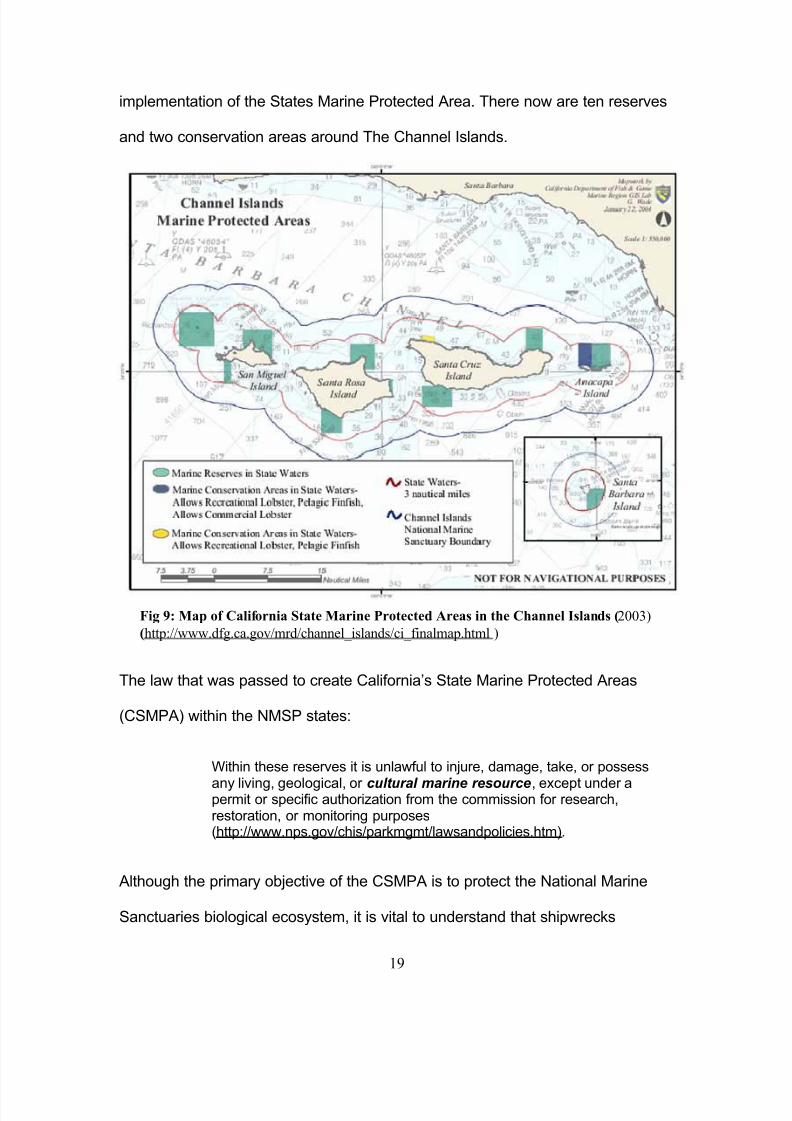
implementation of the States Marine Protected Area. There now are ten reserves
and two conservation areas around The Channel Islands.
The law that was passed to create California’s State Marine Protected Areas
(CSMPA) within the NMSP states:
Within these reserves it is unlawful to injure, damage, take, or possess
any living, geological, or cultural marine resource, except under apermit or specific authorization from the commission for research,restoration, or monitoring purposes(http://www.nps.gov/chis/parkmgmt/lawsandpolicies.htm).
Although the primary objective of the CSMPA is to protect the National Marine
Sanctuaries biological ecosystem, it is vital to understand that shipwrecks
Fig 9: Map of California State Marine Protected Areas in the Channel Islands (2003)
(http://www.dfg.ca.gov/mrd/channel_islands/ci_finalmap.html )

8/6/2019 California's Maritime Heritage
http://slidepdf.com/reader/full/californias-maritime-heritage 20/29
20
become artificial reefs for many biological life forms and therefore become a
consequential part of the ecosystem. CINMS (2006) purports in their Draft
Environmental Impact Statement under ecological impacts of the initiative that
“habitats supporting marine populations are expected to benefit via reduced
disturbance and destruction of physical structures by fishing gear”. One such
physical structure and underwater cultural resource benefiting form these marine
zones is the Winfield Scott. Almost the entire north/west side of Anacapa Island
has been designated as a marine reserve prohibiting any kind of fishing. The
implication of the State reserve is that many activities are restricted, including
recreational diving. Who decides these matters and under which legislations will
now be reviewed.
The following chart is a brief overview of organizational breakdown for The
Channel Islands and associated organizations.
Local State Federal International Non-Governmental
Los AngelesMaritimeMuseum
Santa BarbaraMaritimeMuseum
CaliforniaState LandsCommission
CaliforniaState Parks
National ParksService
NationalOceanographicandAtmosphericAdministration
Nil (but Stateand Federalhave toadhere toUNCLOSsince rejoiningUNESCO in2003)
Coastal MaritimeArchaeologyRecourses
Just to reiterate, each of these bodies create the management and organizational
schemes for the various programs, which have been implemented for The
Channel Islands. Four of these bodies have created sub-organizations, programs
or work with non-governmental organizations to protect, educate, preserve and
8/6/2019 California's Maritime Heritage
http://slidepdf.com/reader/full/californias-maritime-heritage 21/29
21
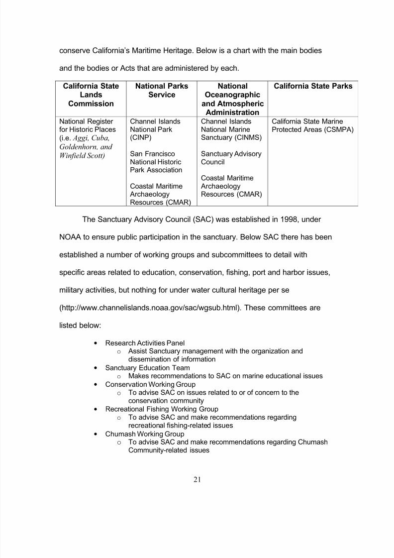
conserve California’s Maritime Heritage. Below is a chart with the main bodies
and the bodies or Acts that are administered by each.
California State
LandsCommission
National Parks
Service
National
Oceanographicand AtmosphericAdministration
California State Parks
National Register for Historic Places
(i.e. Aggi, Cuba,
Goldenhorn, and Winfield Scott)
Channel IslandsNational Park(CINP)
San FranciscoNational HistoricPark Association
Coastal Maritime
ArchaeologyResources (CMAR)
Channel IslandsNational MarineSanctuary (CINMS)
Sanctuary AdvisoryCouncil
Coastal MaritimeArchaeology
Resources (CMAR)
California State MarineProtected Areas (CSMPA)
The Sanctuary Advisory Council (SAC) was established in 1998, under
NOAA to ensure public participation in the sanctuary. Below SAC there has been
established a number of working groups and subcommittees to detail with
specific areas related to education, conservation, fishing, port and harbor issues,
military activities, but nothing for under water cultural heritage per se
(http://www.channelislands.noaa.gov/sac/wgsub.html). These committees are
listed below:
• Research Activities Panelo Assist Sanctuary management with the organization and
dissemination of information
• Sanctuary Education Teamo Makes recommendations to SAC on marine educational issues
• Conservation Working Groupo To advise SAC on issues related to or of concern to the
conservation community
• Recreational Fishing Working Groupo To advise SAC and make recommendations regarding
recreational fishing-related issues
• Chumash Working Groupo To advise SAC and make recommendations regarding Chumash
Community-related issues
8/6/2019 California's Maritime Heritage
http://slidepdf.com/reader/full/californias-maritime-heritage 22/29
22
• Ad Hoc Group on Enforcement of Marine Reserveso They consult law enforcement agencies with regards to enforcing
marine reserve policies
• Sub-committee on Developing Management Plan Performance Measureso To make sure the management plans of the National Marine
Sanctuary Program are productive, effective and, efficient
(http://www.channelislands.noaa.gov/sac/wgsub.html)
There are several other groups listed, but the recreational scuba diving
community does not seem to be represented by any of these groups, nor do they
have a working group of their own. This seems to be a failure in the organization
of the Sanctuary program by SAC. California has a large recreational diving
community, and numerous dive operations travel to the Channel Islands with
customers who like to recreationally dive there. It is possible that because it is a
business for the dive operations that they are represented by the Ad Hoc Group
on Socio-Economic Monitoring of Marine Reserves. This group works closely
with NOAA economists regarding the socio-economic monitoring program
(http://www.channelislands.noaa.gov/sac/wgsub.html). Even if this were the
case, to would seem more reasonable to create a specific working group or sub-
committee for the recreational diving community and dive operators, just as the
recreational fishing community has their own.
The structure and framework involved with so many organizations,
agenda’s and budgets makes analysis of the entire management of California’s
Underwater Cultural Heritage extremely complex because it is only one aspect of
a multi-subject oriented topic. But California’s Underwater Cultural Heritage is not
the only concern for these organizations. They must also balance protection and
preservation of underwater cultural heritage with California’s Maritime Heritage in
general. Both being intertwined by their relations to the sea, and the museums
8/6/2019 California's Maritime Heritage
http://slidepdf.com/reader/full/californias-maritime-heritage 23/29
23
that are used to educate the public, disseminate information and knowledge to
the community, and to preserve the cultural heritage that it not located on the
seafloor.
San Francisco’s Maritime National Historic Park
In 1950 The San Francisco Maritime Museum Association was founded as
a nonprofit, privately owned organization. The maritime museum over the years
purchased land near Fisherman’s Warf and numerous vessels for their historical
collection. On June 27, 1988, Congress passed the Public Law 100-348
establishing the Maritime museum, park areas, and the historic vessels as the
San Francisco Maritime National Historical Park (SFMNHP), a separate
administrative unit of the National Park Service and no longer a privately owned
and run organization, but now part of a governmental body
(http://www.nps.gov/safr/parkmgmt/upload/Safrgmp.pdf).
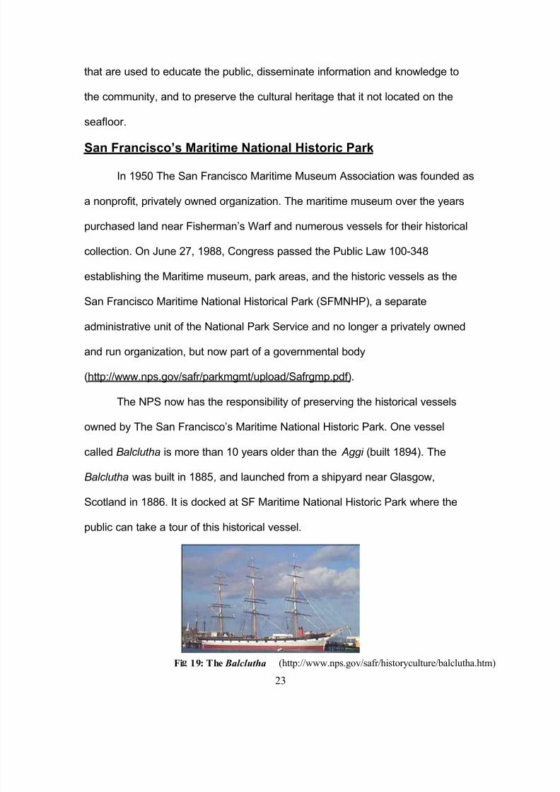
The NPS now has the responsibility of preserving the historical vessels
owned by The San Francisco’s Maritime National Historic Park. One vessel
called Balclutha is more than 10 years older than the Aggi (built 1894). The
Balclutha was built in 1885, and launched from a shipyard near Glasgow,
Scotland in 1886. It is docked at SF Maritime National Historic Park where the
public can take a tour of this historical vessel.
Fi 19: The Balclutha (http://www.nps.gov/safr/historyculture/balclutha.htm)
8/6/2019 California's Maritime Heritage
http://slidepdf.com/reader/full/californias-maritime-heritage 24/29
24
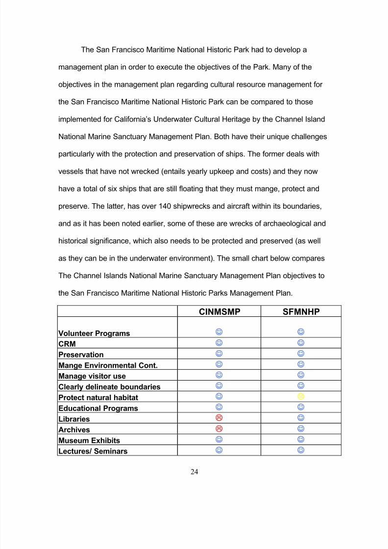
The San Francisco Maritime National Historic Park had to develop a
management plan in order to execute the objectives of the Park. Many of the
objectives in the management plan regarding cultural resource management for
the San Francisco Maritime National Historic Park can be compared to those
implemented for California’s Underwater Cultural Heritage by the Channel Island
National Marine Sanctuary Management Plan. Both have their unique challenges
particularly with the protection and preservation of ships. The former deals with
vessels that have not wrecked (entails yearly upkeep and costs) and they now
have a total of six ships that are still floating that they must mange, protect and
preserve. The latter, has over 140 shipwrecks and aircraft within its boundaries,
and as it has been noted earlier, some of these are wrecks of archaeological and
historical significance, which also needs to be protected and preserved (as well
as they can be in the underwater environment). The small chart below compares
The Channel Islands National Marine Sanctuary Management Plan objectives to
the San Francisco Maritime National Historic Parks Management Plan.
CINMSMP SFMNHP
Volunteer Programs ☺ ☺
CRM ☺ ☺
Preservation ☺ ☺
Mange Environmental Cont. ☺ ☺
Manage visitor use ☺ ☺
Clearly delineate boundaries ☺ ☺
Protect natural habitat ☺ "
Educational Programs ☺ ☺
Libraries # ☺
Archives # ☺
Museum Exhibits ☺ ☺
Lectures/ Seminars ☺ ☺
8/6/2019 California's Maritime Heritage
http://slidepdf.com/reader/full/californias-maritime-heritage 25/29
25
Just from this small sample of management plan goals and objectives, it is clear
to see the providing for the protection and preservation of California’s
Underwater Cultural Heritage is not much unlike providing for, and protection of,
California’s Maritime Heritage above the sea. The strategies are very different
but that is accounted for by the differences in environments.
What This All Means
When a subject as wide as California’s Maritime Heritage is analyzed in
such a short essay, it can be difficult to pull in the most significant aspects that
pertain to it in a cohesive and interesting fashion. Firstly, a historical context
needed to be established for maritime cultural heritage. In California, the
maritime cultural heritage extends as far back as circa 800 to 150 before the
present, with the settlement of the Chumash Indians along the California coast
and Channel Islands. The Chumash Indians and their maritime technologies
represent a very important place in local cultural heritage within California. But
cultural heritage, whether of a maritime nature or in general, does not begin and
end with the local aspect. As it has been shown, California’s Maritime Cultural
Heritage is rich throughout time. Historical documents place both the Spanish
Manila Galleons and Sir Francis Drake within California State territorial waters,
bays and along California’s coastline in the 16th century. These events broaden
California’s Maritime History and Heritage and places it within an international
setting. If The National Parks Service finds the remains of the Spanish Galleon
San Augustin, California’s Underwater Cultural Heritage will have the
8/6/2019 California's Maritime Heritage
http://slidepdf.com/reader/full/californias-maritime-heritage 26/29
26
archaeological remains of its earliest known shipwreck, and its own linkage to
early European Maritime History through those cultural material remains instead
of just historical documentation.
It has also been shown that early modern maritime history (within the last
three centuries) plays a vital role in California’s Maritime Heritage: both above
and below the sea. This material culture, which is so important to California’s
Maritime Heritage and its identity, must be managed in order for it to protected
and preserved. The latter half of this essay discussed the various laws,
organizations, and governmental bodies that are appropriated with these
responsibilities. Several charts were used to categorize the organizations
according to local, state, federal, international and non-governmental bodies
involved in or responsible for California’s Maritime Cultural Heritage. And finally,
a brief comparison between management plans used by two different
organizations for the purpose of protecting and preserving California’s Maritime
Heritage underwater and above.
By covering the material in this format, it was possible to answer all of the
questions posed at the being of this essay clearly. The role each of these
organizations play in preservation, education, protection, dissemination, and
conservation of California’s Maritime Heritage through sanctuaries, museums,
preservations, and parks has been addressed and the objectives set forth at the
being of this essay have been reached.
8/6/2019 California's Maritime Heritage
http://slidepdf.com/reader/full/californias-maritime-heritage 27/29
27
Bibliography
America’s National Register of Historic Places. Wikipedia Online. Consulted09.02.03 <http://en.wikipedia.org/wiki/National_Register_of_Historic_Places>
British Museum, The (2007) Maris Pacifici , circa 1592 (British Museum onlinecollection) consulted 02.03.07<http://www.imagesonline.bl.uk/britishlibrary/controller/subjectidsearch?id=995&startid=4500&width=4&height=2&idx=2>
California State Lands Commission (2004) Cabrillo Port Liquefied natural GasDeepwater Port—Draft EIS/EIR (Sacramento: California State LandsCommission)
Channel Islands National Marine Sanctuary (2007) Maritime Heritage (NOAA
online) consulted 10.02.07 < http://channelislands.nos.noaa.gov/cr/main.html>
Channel Islands National Marine Sanctuary (2007a) Sanctuary Advisory Council (NOAA online) consulted 10.02.07<http://www.channelislands.noaa.gov/sac/main.html>
Channel Islands National Marine Sanctuary (2007b) CINMS Shipwreck Database (Santa Barbara: Channel Islands National Marine Sanctuary)
Channel Islands National Marine Sanctuary (2006b) Channel Islands DatumInstallation Project National Historic Preservation Act: Section 106 Review.
(CINMS: Santa Barbara).
Chartkoff, J and K. Chartkoff (1984) The Archaeology of California (Stanford:Stanford University)
Chumash Exhibit. Santa Barbara Maritime Museum (online) consulted 17.02.03<http://www.sbmm.org/exhibits_mainfloor.php#chumash>
Coastal Maritime Archaeology Resources (CMAR online) consulted 23.02.07<http://www.cmar.us/about>
Color Map of Channel Islands MPA’s (2003) California Department of Fish and Game, Marine Region online. Consulted 09.02.07<http://www.dfg.ca.gov/mrd/channel_islands/ci_finalmap.html>
Green. J. (2004) Maritime Archaeology: A Technical Handbook 2 nd ed. (Elsevier Academic Press: San Diego).
8/6/2019 California's Maritime Heritage
http://slidepdf.com/reader/full/californias-maritime-heritage 28/29
28
Office of Historic Preservation (1997) Forging A Future With A Past: AComprehensive Statewide Historic Preservation Plan For California. OHP:Sacramento).
Oxley, I (1998) The Investigation of The Factors The Affect the Preservation of
Underwater Archaeological Sites. In L. Babits and H.V Tilburg (eds.) Maritime Archaeology: A Reader of Substantive and Theoretical Contributions (PlenumPress: New York).
Map of California Coast/Channel Islands. (Answers.com) consulted 28.02.07< http://www.answers.com/topic/channel-islands-of-california>
Marine Park Association (2007) San Francisco Maritime National Park Association (Marine Park Association online) consulted 10.02.07< http://www.maritime.org/index.htm>
Minerals Management Service (MMS) U.S. Department of Interior (2006) ManilaGalleons (online) consulted 25.02.07<http://www.mms.gov/omm/pacific/kids/manilagalleons.htm>
Mystic Seaport: The Museum of America and the Sea (2007) The Illustrated London News (1849) consulted 05.03.07http://www.mysticseaport.org/library/Images/l026409/l026409-002-r.gif
National Marine Protected Area Center (2006) Marine Protected Areas, MarineCultural and Historic Newsletter 3.04: 1-24.
National Oceanic and Atmospheric Administration (NOAA) U.S. Department of Commerce (2006) CBNMS Draft Management Plan. (NOAA: Washington).
National Oceanic and Atmospheric Administration (NOAA) U.S. Department of Commerce (2006a) Draft Environmental Impact Statement—CINMS MarineReserves (NOAA: Washington)
National Oceanic and Atmospheric Administration (NOAA) U.S. Department of Commerce (2005a) Encyclopedia of The Sanctuary: National Marine Sanctuaries(NOAA online) consulted 30.01.07< http://marinelife.noaa.gov/>
National Oceanic and Atmospheric Administration (NOAA) U.S. Department of Commerce (2004b) Historical Map & Chart Project (NOAA online) consulted17.02.07 < http://historicals.ncd.noaa.gov/historicals/histmap.asp>
National Parks Service (2005) Channel Islands National Park (NPS online)consulted 20.02.07< http://www.nps.gov/archive/chis/homepage.htm>
National Parks Service (2007a) Balclutha (NPS online) consulted 20.02.03< http://www.nps.gov/safr/historyculture/balclutha.htm>
8/6/2019 California's Maritime Heritage
http://slidepdf.com/reader/full/californias-maritime-heritage 29/29
National Parks Service (1997) San Francisco Maritime National Historic Park General Management Plan (online) consulted 15.02.07<http://www.nps.gov/safr/parkmgmt/upload/Safrgmp.pdf>
National Parks Service (no date) National Register of Historic Places (online)consulted 09.02.07 http://www.cr.nps.gov/nr/travel/
Northern Maritime Research (2002) Northern Shipwrecks Database (CD-ROM)(Northern Maritime Research: Nova Scotia)
Oakland Museum of California (1998) Gold Rush! California’s Untold Stories.(Oakland Museum of California online) consulted 06.03.07http://www.museumca.org/goldrush/>
Panama Canal. Wikipedia online. Consulted 17.02.07
<http://en.wikipedia.org/wiki/Panama_Canal>
Raymond, A. (1978) Sir Francis Drake at Drakes Bay: A Summation of evidencerelating to the identification of Sir Francis Drake’s encampment at Drakes Bay,California, based on the research of the Drake Navigators Guild (Palo Alto: TheGuild).
Sanctuary Advisory Council (2006) Channel Islands Marine Sanctuary online.Consulted 25.02.07 < http://www.channelislands.noaa.gov/sac/wgsub.html>
Santa Cruz Island Foundation (no date) A Brief History of California’s Channel Islands (online) consulted 17.02.07 <http://www.west.net/~scifmail/history.html>
Panama Canal: Historical Atlas By W. Shepard, 1923. University of Texas, at AustinOnline. Consulted 09.03.07<http://www.lib.utexas.edu/maps/historical/shepherd/panama_canal_shepherd.jpg>