Calcasieu River and ApproachesBookletChart Calcasieu River and Approaches NOAA Chart 11339 A reduced...
24
BookletChart ™ Calcasieu River and Approaches NOAA Chart 11339 A reduced-scale NOAA nautical chart for small boaters When possible, use the full-size NOAA chart for navigation. Included Area
Transcript of Calcasieu River and ApproachesBookletChart Calcasieu River and Approaches NOAA Chart 11339 A reduced...
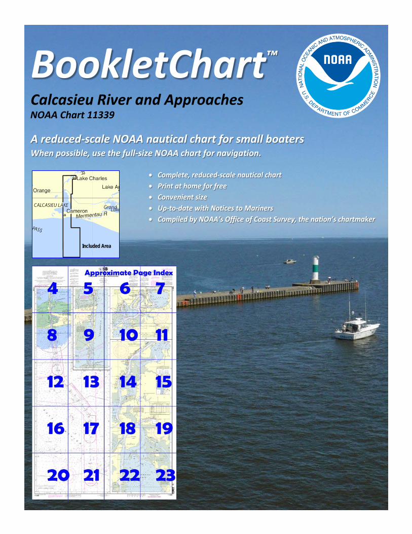
BookletChart™ Calcasieu River and Approaches NOAA Chart 11339
A reduced-scale NOAA nautical chart for small boaters When possible, use the full-size NOAA chart for navigation.
Included Area

2
Published by the National Oceanic and Atmospheric Administration
National Ocean Service Office of Coast Survey
www.NauticalCharts.NOAA.gov 888-990-NOAA
What are Nautical Charts?
Nautical charts are a fundamental tool of marine navigation. They show water depths, obstructions, buoys, other aids to navigation, and much more. The information is shown in a way that promotes safe and efficient navigation. Chart carriage is mandatory on the commercial ships that carry America’s commerce. They are also used on every Navy and Coast Guard ship, fishing and passenger vessels, and are widely carried by recreational boaters.
What is a BookletChart?
This BookletChart is made to help recreational boaters locate themselves on the water. It has been reduced in scale for convenience, but otherwise contains all the information of the full-scale nautical chart. The bar scales have also been reduced, and are accurate when used to measure distances in this BookletChart. See the Note at the bottom of page 5 for the reduction in scale applied to this chart.
Whenever possible, use the official, full scale NOAA nautical chart for navigation. Nautical chart sales agents are listed on the Internet at http://www.NauticalCharts.NOAA.gov.
This BookletChart does NOT fulfill chart carriage requirements for regulated commercial vessels under Titles 33 and 44 of the Code of Federal Regulations.
Notice to Mariners Correction Status
This BookletChart has been updated for chart corrections published in the U.S. Coast Guard Local Notice to Mariners, the National Geospatial Intelligence Agency Weekly Notice to Mariners, and, where applicable, the Canadian Coast Guard Notice to Mariners. Additional chart corrections have been made by NOAA in advance of their publication in a Notice to Mariners. The last Notices to Mariners applied to this chart are listed in the Note at the bottom of page 7. Coast Pilot excerpts are not being corrected.
For latest Coast Pilot excerpt visit the Office of Coast Survey website at http://www.nauticalcharts.noaa.gov/nsd/searchbychart.php?chart=11339.
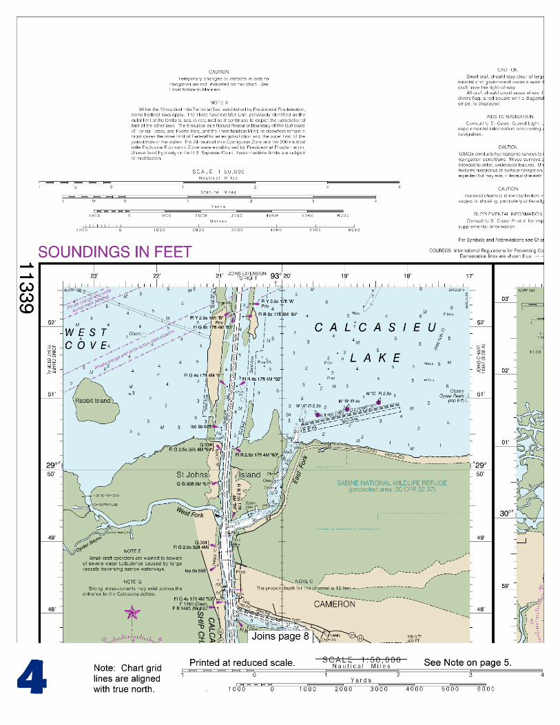
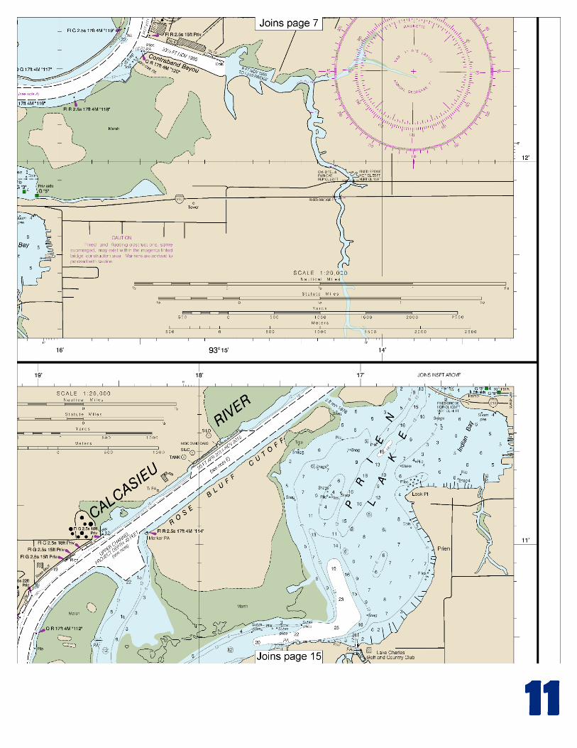
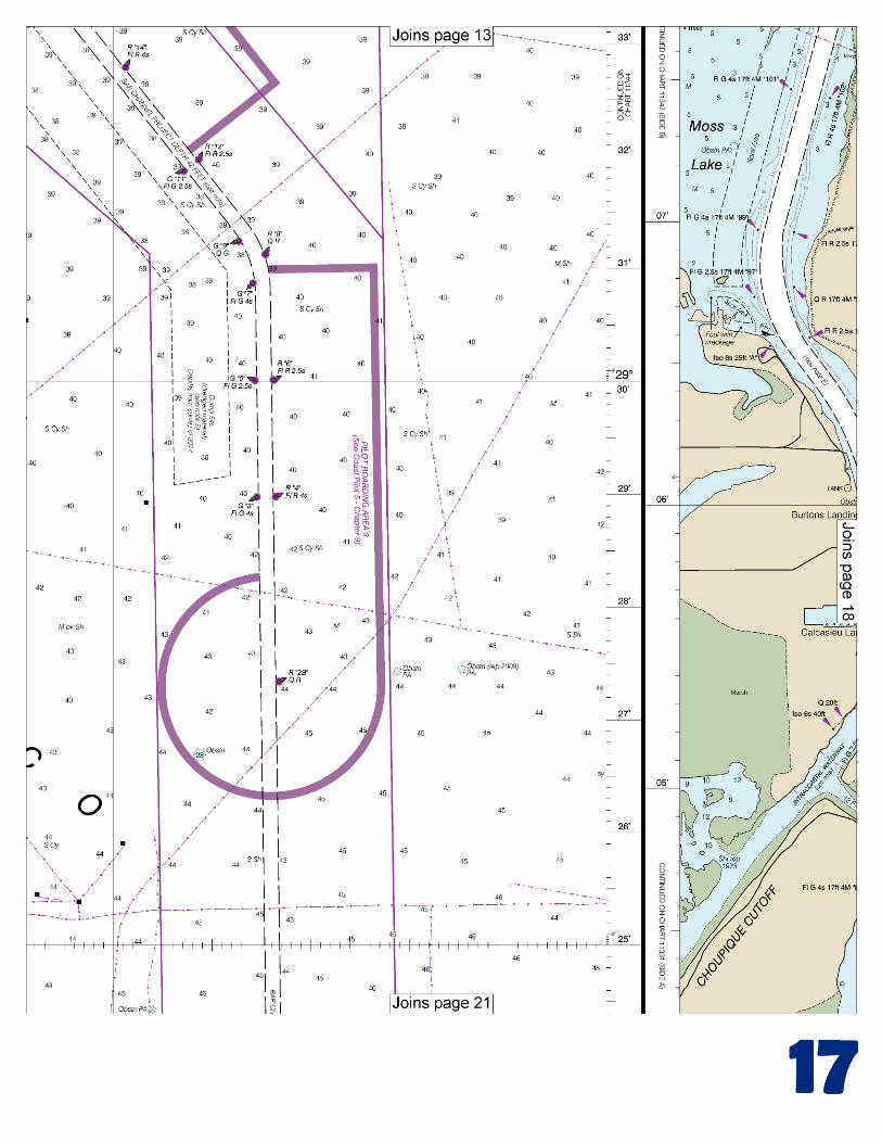
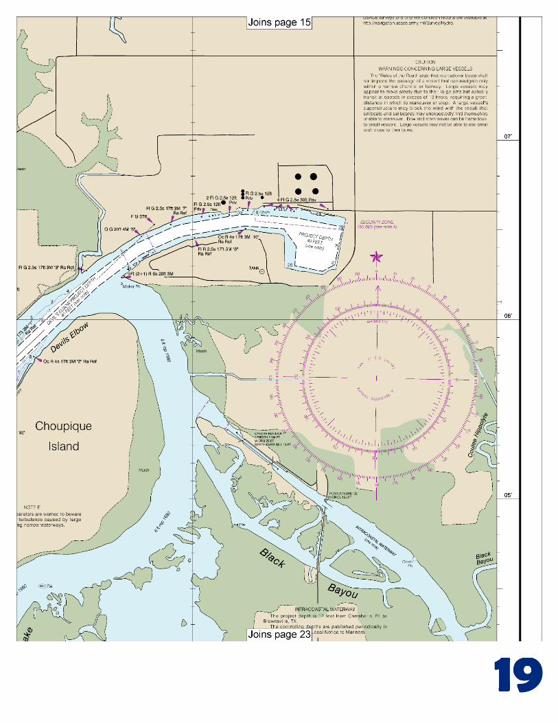
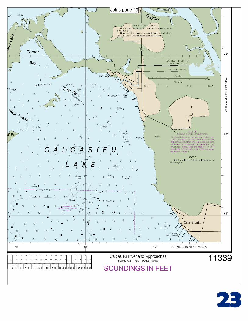
(Selected Excerpts from Coast Pilot) Calcasieu Pass, the outlet of Calcasieu Lake, is about 98 miles W of Atchafalaya Bay entrance and 78 miles E of Galveston entrance. It is the first and only deep-draft channel W of the Mississippi River and E of Sabine Pass. Prominent features.–In the vicinity of Calcasieu Pass are the range and jetties and, at night, the occulting red obstruction lights on the many radio towers in the area. A regulated navigation area has been
established in Calcasieu River from the Calcasieu jetties to and including the Port of Lake Charles. (See 165.1 through 165.13 and 165.807, chapter 2, for limits and regulations.)
The Trunkline liquified natural gas facility on Industrial Canal is within a safety zone. Additionally, the waters surrounding non-gasfree LNG carriers transiting Calcasieu River are a safety zone. (See 165.1 through 165.7, 165.20, 165.23, and 165.805, chapter 2, for limits and regulations.) Channels.–The Calcasieu entrance has been improved by jetties and a deepwater channel. The jetties extend seaward from the shoreline for about 1.1 miles and are mostly above normal high tide. A Federal project provides for a channel 42 feet deep across the outer bar from that depth in the Gulf to the entrance jetties, thence 40 feet through the jetties, thence to and in the Industrial Canal and turning basin N of Choupique Island, thence to the Port of Lake Charles wharves, and thence 35 feet to the Interstate Route 10/U.S. Route 90 highway bridge. (See Notice to Mariners and latest editions of charts for controlling depths.) The channel is marked by lighted buoys and lights. Anchorages.–Large vessels should anchor in Calcasieu Pass Fairway Anchorage, E of the safety fairway. (See 166.100 through 166.200, chapter 2.) Vessels up to 12 feet in draft can obtain excellent anchorage in the bend in the river at Cameron. While waiting for daylight or fog to lift, ships can anchor out of the fairway anywhere in Calcasieu River. No anchorages exist in the landcuts, and ships entering cuts are expected to complete passage. Deep-draft vessels normally anchor 2 to 3 miles SE of the Pilot Boarding Station No. 4, being cognizant to avoid charted pipelines. Dangers.–Seaward of the jetties, a moderate to strong current sweeps across the channel, normally setting in a W direction; however, strong W winds will cause a current reversal; mariners should exercise caution and be on the alert. Numerous collisions have occurred at the entrance to the jetties due to this set across the channel. Meeting or overtaking situations near the entrance should be avoided. A mud slush lying on the bottom, approximately 6 feet above the hard surface, frequently will be found in the channel seaward of the jetties and at various places above the pass. This material can hardly be detected by the leadline. A 1- to 4-foot layer of soupy material, some 8 to 10 feet above the hard bottom and 20 to 23 feet below the surface, occasionally is encountered in the same localities. Spoil banks of undetermined depth exist on the W side of the entrance channel and outer channel except within a mile N and S of Calcasieu Channel Lighted Buoy 29, which area, the Lake Charles Pilots report, has been left clear for Pilot Station No. 1. Mariners are advised to avoid navigating across the spoil banks, because the actual depths may be considerably less than the charted depths. In 1981, a submerged obstruction was reported in the fairway anchorage W of the safety fairway in about 29°37.3'N., 93°27.7'W. Currents.–Currents at Camer Berthage, electricity, gasoline, diesel fuel, water, ice, wet storage, marine supplies, a 30-ton hoist for hull, engine and electronic repairs, and reported depths to 8 feet are available in facilities across the river from the Port of Lake Charles, NE of Berths 1, 2, and 3. Facilities on Contraband Bayou provide berthage, electricity, gasoline, diesel fuel, water, ice, pump-out station, launching ramp, dry storage, marine supplies, and a 30-ton hoist for vessels to 80 feet for hull, engine and electronic repairs. Good anchorage is available in the lake in depths of 8 to 10 feet. A marina off the Calcasieu River, about 0.9 mile N of Lake Charles, has gasoline, launching ramp, water and ice.
U.S. Coast Guard Rescue Coordination Center
24 hour Regional Contact for Emergencies
RCC New Orleans Commander 8th CG District (504) 589-6225 New Orleans, LA

G
NOAA’s navigation managers serve as ambassadors to the maritime community. They help identify navigational challenges facing professional and recreational mariners, and provide NOAA resources and information for safe navigation. For additional information, please visit nauticalcharts.noaa.gov/service/navmanagers
To make suggestions or ask questions online, go to nauticalcharts.noaa.gov/inquiry. To report a chart discrepancy, please use ocsdata.ncd.noaa.gov/idrs/discrepancy.aspx.
Lateral System As Seen Entering From Seaward on navigable waters except Western Rivers
PORT SIDE
ODD NUMBERED AIDS
GREEN LIGHT ONLY
FLASHING (2)
PREFERRED CHANNEL
NO NUMBERS – MAY BE LETTERED
PREFERRED CHANNEL TO
STARBOARD
TOPMOST BAND GREEN
PREFERRED CHANNEL
NO NUMBERS – MAY BE LETTERED
PREFERRED CHANNEL
TO PORT
TOPMOST BAND RED
STARBOARD SIDE
EVEN NUMBERED AIDS
RED LIGHT ONLY
FLASHING (2)
FLASHING FLASHING
OCCULTING GREEN LIGHT ONLY RED LIGHT ONLY OCCULTING QUICK FLASHING QUICK FLASHING
ISO COMPOSITE GROUP FLASHING (2+1) COMPOSITE GROUP FLASHING (2+1) ISO
"1"
Fl G 6s
G "9"
Fl G 4s
GR "A"
Fl (2+1) G 6s
RG "B"
Fl (2+1) R 6s
"2"
Fl R 6s
8
R "8"
Fl R 4s
LIGHT
G
C "1"
LIGHTED BUOY
G
"5"
GR
"U"
GR
C "S"
RG
N "C"
RG
"G"
LIGHT
6
R
N "6"
LIGHTED BUOY
R
"2
"
CAN DAYBEACON
CAN NUN NUN
DAYBEACON
For more information on aids to navigation, including those on Western Rivers, please consult the latest USCG Light List for your area.
These volumes are available online at http://www.navcen.uscg.gov
Navigation Managers Area of Responsibility
Northeast
Lt. Meghan McGovern
Northwest and
Pacific Islands
Crescent Moegling
Great Lakes Region
Tom Loeper
Chesapeake and
Delaware Bay
Steve Soherr
California
Jeff Ferguson
[email protected] Mid-Atlantic
Lt. Ryan Wartick
Alaska
Lt. Timothy M. Smith
Western Gulf Coast
Alan Bunn
Central Gulf Coast
Tim Osborn
[email protected] South Florida
Puerto Rico
U.S. Virgin Islands
Michael Henderson
Southeast
Kyle Ward
2
2 C U 5
1


VHF Marine Radio channels for use on the waterways:Channel 6 – Inter-ship safety communications.Channel 9 – Communications between boats and ship-to-coast.Channel 13 – Navigation purposes at bridges, locks, and harbors.Channel 16 – Emergency, distress and safety calls to Coast Guard and others, and to initiate calls to other
vessels. Contact the other vessel, agree to another channel, and then switch.Channel 22A – Calls between the Coast Guard and the public. Severe weather warnings, hazards to navigation and safety warnings are broadcast here.Channels 68, 69, 71, 72 and 78A – Recreational boat channels.
Getting and Giving Help — Signal other boaters using visual distress signals (flares, orange flag, lights, arm signals); whistles; horns; and on your VHF radio. You are required by law to help boaters in trouble. Respond to distress signals, but do not endanger yourself.
EMERGENCY INFORMATION
Distress Call Procedures
• Make sure radio is on.• Select Channel 16.• Press/Hold the transmit button.• Clearly say: “MAYDAY, MAYDAY, MAYDAY.”• Also give: Vessel Name and/or Description;Position and/or Location; Nature of Emergency; Number of People on Board.• Release transmit button.• Wait for 10 seconds — If no responseRepeat MAYDAY call.
HAVE ALL PERSONS PUT ON LIFE JACKETS!
This Booklet chart has been designed for duplex printing (printed on front and back of one sheet). If a duplex option is not available on your printer, you may print each sheet and arrange them back-to-back to allow for the proper layout when viewing.
QR
Quick ReferencesNautical chart related products and information - http://www.nauticalcharts.noaa.gov
Interactive chart catalog - http://www.charts.noaa.gov/InteractiveCatalog/nrnc.shtmlReport a chart discrepancy - http://ocsdata.ncd.noaa.gov/idrs/discrepancy.aspx
Chart and chart related inquiries and comments - http://ocsdata.ncd.noaa.gov/idrs/inquiry.aspx?frompage=ContactUs
Chart updates (LNM and NM corrections) - http://www.nauticalcharts.noaa.gov/mcd/updates/LNM_NM.html
Coast Pilot online - http://www.nauticalcharts.noaa.gov/nsd/cpdownload.htm
Tides and Currents - http://tidesandcurrents.noaa.gov
Marine Forecasts - http://www.nws.noaa.gov/om/marine/home.htm
National Data Buoy Center - http://www.ndbc.noaa.gov/
NowCoast web portal for coastal conditions - http://www.nowcoast.noaa.gov/
National Weather Service - http://www.weather.gov/
National Hurrican Center - http://www.nhc.noaa.gov/
Pacific Tsunami Warning Center - http://ptwc.weather.gov/
Contact Us - http://www.nauticalcharts.noaa.gov/staff/contact.htm
NOAA’s Office of Coast Survey The Nation’s Chartmaker
For the latest news from Coast Survey, follow @NOAAcharts
NOAA Weather Radio All Hazards (NWR) is a nationwide network of radio stations broadcasting continuous weather information directly from the nearest National Weather Service office. NWR broadcasts official Weather Service warnings, watches, forecasts and other hazard information 24 hours a day, 7 days a week. http://www.nws.noaa.gov/nwr/