Cadair Idris Special Area of Conservationnaturalresources.wales/media/671054/Cadair Idris SAC Plan...
78
CYNGOR CEFN GWLAD CYMRU COUNTRYSIDE COUNCIL FOR WALES CORE MANAGEMENT PLAN INCLUDING CONSERVATION OBJECTIVES FOR Cadair Idris Special Area of Conservation Version: 2 (Minor map edit August 2012) Date: 31 January 2012 Approved by: Mike Willis 31 st January 2012 A Welsh version of all or part of this document can be made available on request.
Transcript of Cadair Idris Special Area of Conservationnaturalresources.wales/media/671054/Cadair Idris SAC Plan...
CYNGOR CEFN GWLAD CYMRU COUNTRYSIDE COUNCIL FOR WALES
CORE MANAGEMENT PLAN INCLUDING CONSERVATION OBJECTIVES
FOR
Cadair Idris Special Area of Conservation Version: 2 (Minor map edit August 2012) Date: 31 January 2012 Approved by: Mike Willis 31 st January 2012 A Welsh version of all or part of this document can be made available on request.
2
CONTENTS Preface: Purpose of this document 1. Vision for the Site................................................................................................................. 3 2. Site Description
2.1 Area and Designations Covered by this Plan....................................................... 4 2.2 Outline Description................................................................................................. 4 2.3 Outline of Past and Current Management……………………………………... 5 2.4 Management Units……………………………………………………………….. 5
3. The Special Features
3.1 Confirmation of Special Features......................................................................… 6 3.2 Special Features and Management Units...................................................…….. 6
4. Conservation Objectives for SAC features Background to Conservation Objectives 4.1 Clear-water lakes............................................................................................................. 9 4.2 Scree ............................................................................................................................... 12 4.3 Calcareous chasmophytic vegetation+ (combined in section 4) ……………………… 15 4.3 Siliceous chasmophytic vegetation.+ (combined in section 4) ……………………….. 15 4.3 Tall herb ledge communities+(combined in section 4) ……………………………….. 15 4.4 Dry heaths* combined in section 4 .............................................................…………...22 4.4 Wet heaths* combined in section 4.................................................................………… 22 4.5 Blanket bogs.................................................................................................................... 27 4.6 Oak woods...................................................................................................................... 32 4.7 Molinia meadows............................................................................................................ 38 4.8 Alkaline fens................................................................................................................... 42 4.9 Slender green feather moss ............................................................................................47 4.10 Marsh fritillary.............................................................................................................. 52
5. Assessment of Conservation Status and Management Requirements for SAC features:
5.1 Clear-water lakes............................................................................................................. 57 5.2 Scree ............................................................................................................................... 57 5.3 Calcareous chasmophytic vegetation+ (combined in section 5) ………………… .….. 58 5.3 Siliceous chasmophytic vegetation.+ (combined in section 5) ……………………….. 58 5.3 Tall herb ledge communities+(combined in section 5) ……………………………….. 58 5.4 Dry heaths* (combined in section 5) .............................................................………… 60 5.4 Wet heaths* (combined in section 5).................................................................………. 60 5.5 Blanket bogs.................................................................................................................... 62 5.6 Oak woods...................................................................................................................... 63 5.7 Molinia meadows**(combined in section 5)......................................................……… 64 5.8 Alkaline fens**(combined in section 5).............................................................…........ 64 5.9 Slender green feather moss**(combined in section 5).........................................…….. 64 5.10 Marsh fritillary.............................................................................................................. 66
6. Action Plan: Summary.............................................................................................………68 7. Glossary 8. References and Annexes

3
PREFACE This document provides the main elements of CCW’s management plan for the site named. It sets out what needs to be achieved on the site, the results of monitoring and advice on the action required. This document is made available through CCW’s web site and may be revised in response to changing circumstances or new information. This is a technical document that supplements summary information on the web site. One of the key functions of this document is to provide CCW’s statement of the Conservation Objectives for the relevant Natura 2000 site. This is required to implement the Conservation (Natural Habitats, &c.) Regulations 1994, as amended (Section 4). As a matter of Welsh Assembly Government Policy, the provisions of those regulations are also to be applied to Ramsar sites in Wales.
1. VISION FOR THE SITE
This is a descriptive overview of what needs to be achieved for conservation on the site. It brings together and summarises the Conservation Objectives (part 4) into a single, integrated statement about the site but currently only covers the SAC features. Cadair Idris is a remarkable upland landscape, at the southern most limit for a number of alpine species and vegetation types in Britain. The site encompasses the mountain and lower slopes which are a mosaic of habitats including woodland and the species-rich Molinia grasslands of Tir Stent common. The low nutrient or clear-water lakes should be maintained as naturally clear and unpolluted, with hopefully reduced inputs of acid rain. The acid or base-poor nature of much of the underlying rock means that the lakes are especially vulnerable to acidification. The vegetated scree should be maintained in its current favourable condition. The tall herb ledges and chasmophytic vegetation should be maintained and preferably increased in area beyond the current ledges to which they are confined by current grazing. The dry heath, wet heath and blanket bog should be restored by grazing and water level management and be encouraged to increase at the expense of less desirable vegetation. The fragile damp, moss and liverwort rich heath should continue to flourish and increase in cover on suitable north and northeast facing slopes. In the longer term, the development of open woodland and scattered trees onto heath, as a more natural tree line develops, is considered desirable. The woodland area should remain stable or increase by trees spreading up onto the mountain and by bracken communities developing into woodland or wood pasture. The woodland condition should be restored by eradication of rhododendron and invasive species and the managed removal of most conifers and other non-natives over the longer-term. The Molinia grassland, alkaline fen and slender green feather moss should be maintained in area and location by appropriate management particularly grazing. Similarly the population of marsh fritillary at Tir Stent, (and on neighbouring habitat off the SAC), would benefit from restoration habitat management so that this butterfly meta population does not decline.

4
2. SITE DESCRIPTION 2.1 Area and Designations Covered by this Plan The coverage of this plan adheres to the boundaries of Cadair Idris SAC. Grid reference(s): centred on approximately SH710130 Unitary authority: Gwynedd County Council. Area (hectares): 3785 ha Designation covered: Cadair Idris Special Area of Conservation
Map. SAC, SSSI, and NNR designations at Cadair Idris. This plan covers the green area only.
2.2 Outline Description The site is located to the south of Dolgellau and is of special interest for its biological, Ordovician/igneous bedrock geology and Pleistocene/Quaternary geomorphology features. Cadair Idris SAC is underpinned by Cadair Idris SSSI. The woodlands on the northern edge of the SSSI form part of Coedydd Derw a Safleoedd Ystlumod Meirion SAC and are not covered by this plan. The site encompasses Cadair Idris mountain and the lower slopes, which are a mosaic of broadleaved woodland, wet meadows, upland habitats and grassland. It is a truly spectacular area with very many habitats and species, which are of national and international importance. The broad range of physical conditions gives rise to a wide range of habitat types. These include dwarf scrub heath communities, montane grasslands, herb- and fern-rich communities, blanket mire, soligenous flush communities, a spring-flush habitat, open water and oak woodland. The most prevalent are acid grasslands dominated by Nardus stricta and Festuca ovina and acid dry heaths dominated by Calluna

5
vulgaris. In the context of the SSSI the site is also of special interest for its assemblage of higher plants, lichens, bryophytes and montane invertebrates. Nine higher plants are of special interest in their own right as is the (SAC feature) slender green feather moss Hamatocaulis vernicosus and an edge of range lichen species. Also of special interest are populations of the marsh fritillary butterfly, Welsh clearwing moth, and lesser horseshoe bat. Cadair Idris SAC includes five oligotrophic lakes, namely Llyn y Gadair, Llyn Gafr, Llyn Arran, Llyn Cyri, and Llyn Cau. The Cadair Idris National Nature Reserve forms an area of approximately 450 hectares in the heart of the site, including Cwm Cau and Penygadair. CCW also own and manage an area of mixed woodland adjacent to the NNR at Ystradlyn, and c81ha of undeclared reserve on the lower north slopes of the site at Tanygader. Cadair Idris is without doubt the walking honey-pot of south Eryri. An estimated 168,000 people visited the NNR in 2007. 2.3 Outline of Past and Current Management Although it is thought that no systematic archaeological surveys have been undertaken at Cadair Idris, several historical remains are known, and items such as the so-called ‘Talyllyn hoard’ are evidence of a long use of the site by humans. The iron-age hoard found on the NNR included decorative plaques which probably once formed part of shields, and are dated to the second century BC. Local naturalist E. Price-Evans considered that "the initial and major interference with vegetation" on Cadair Idris (presumably tree-felling) took place even before then in the Bronze Age. Tithe maps of the area (c.1840) suggest that very little remained wooded by the mid nineteenth century; indeed probably less than at the present day. As in other upland areas of Wales, it is known that cattle were the main grazing animals until the second half of the eighteenth century. The growth of the wool industry led to an inevitable increase in sheep numbers in the uplands, and a shift to concentrating on the production of lamb in the twentieth century further increased the number of livestock on farms. Grazing, predominantly by sheep, continues to be the main land use at Cadair Idris SAC today. Heather and grass burning has featured in the past management of the site, and it has continued to take place periodically, with some owners considering it more important than others, as a tool for management. No deliberate burning has taken place in the NNR since its declaration in 1955. The geology of the mountain has not only influenced the vegetation, and shaped the agricultural management of the site, but it has also attracted the attention of mineral prospectors over the years too. Small scale slate and metal mining has taken place across the site, with much of the workings now obscured by vegetation or later development. And of course the mountain continues to attract climbers and walkers in large numbers, as well as educational groups who come mainly to study the geomorphological features of Cwm Cau. Today, several of the farms who manage land in the SAC have Tir Gofal agreements, with some having taken part in its predecessor agri-environment scheme, Tir Cymen. These agreements have generally led to a reduction in livestock numbers on the mountain, with a further reduction, or removal of stock in some areas over the winter months. Some 500 hectares of the site, including the NNR and Tanygader is managed directly by CCW. In addition, the National Trust manage four blocks of land in the SAC. A formal partnership between CCW, SNPA and NT has sought to control some of the erosion caused to footpaths by the increasing visitor numbers, but European funding ends in 2008 leaving the partners facing a difficult predicament for the future of access management.

6
2.4 Management Units The plan area has been divided into management units to enable practical communication about features, objectives, and management. This will also allow us to differentiate between the different designations where necessary. In this plan the management units have been based mainly on tenure and fenced management units under different management regimes. Some units are based on the distribution of a feature of interest.
A map showing the management Units referred to in this plan is attached. Units 1-40 are all Cadair Idris SAC and SSSI. Units 1-4 are also NNR.

7
3. THE SAC FEATURES 3.1 Confirmation of Special Features Designated feature Relationships, nomenclature etc Conservat
ion Objective in part 4
Cadair Idris SAC features Annex I habitats which are the primary reason for selection of this site Oligotrophic to mesotrophic standing waters
Clear-water lakes with aquatic vegetation and poor to moderate nutrient levels.
4.1
Siliceous scree NVC U21 Cryptogramma crispa – Deschampsia flexuosa vegetation .
4.2
Calcareous rocky slopes with chasmophytic vegetation
Not adequately covered by the NVC 4.3
Siliceous rocky slopes with chasmophytic vegetation.
Some forms can be referred to NVC U21 Cryptogramma crispa – Deschampsia flexuosa community.
4.3
Annex I habitats present as a qualifying feature, but not a primary reason for selection of this site Hydrophilous tall herb fringe communities
NVC U17 Luzula sylvatica – Geum rivale tall-herb community.
4.3
European dry heath NVC H8, H10, H12, H18, H21.
4.4
Northern Atlantic wet heath NVC M15. 4.4 Blanket bog NVC: M17, M19. 4.5 Old sessile oak woods with Ilex and Blechnum in the British Isles
NVC: W11, W17.
4.6
Molinia meadows NVC M24, M26. 4.7 Alkaline fens NVC M10 4.8 Annex II species present as a qualifying feature, but not a primary reason for selection of this site
Slender green feather-moss Drepanocladus vernicosus 4.9 Marsh fritillary Eurodryas aurinia 4.10
3.2 Special Features and Management Units This section sets out the relationship between the special features and each management unit. This is intended to provide a clear statement about what each unit should be managed for, taking into account the varied needs of the different special features. All special features are allocated to one of seven classes in each management unit. These classes are: Key Features KH - a ‘Key Habitat’ in the management Unit, i.e. the habitat that is the main focus of management and monitoring effort, perhaps because of the dependence of a key species (see KS below). There will rarely be more than one Key Habitat in a Unit. KS – a ‘Key Species’ in the management Unit, often driving both the selection and management of a
Key Habitat. Geo – an earth science feature that is the main focus of management and monitoring effort in a Unit. Other Features Sym - habitats, species and earth science features that are of importance in a Unit but are not the main focus of management or monitoring. These features will benefit from management for the key feature(s) identified in the Unit. These may be classed as ‘Sym’ features because:
a) they are present in the Unit but are of less conservation importance than the key feature; and/or

8
b) they are present in the Unit but in small areas/numbers, with the bulk of the feature in other Units of the site; and/or
c) their requirements are broader than and compatible with the management needs of the key feature(s).
Nm - an infrequently used category where features are at risk of decline within a Unit as a result of meeting the management needs of the key feature(s), i.e. under Negative Management. These cases will usually be compensated for by management elsewhere in the plan, and can be used where minor occurrences of a feature would otherwise lead to apparent conflict with another key feature in a Unit.
Mn - Management Units with no special feature present but which are of importance for management of features elsewhere on a site e.g. livestock over-wintering area included within designation boundaries.
x – Features not present in the management Unit.

9
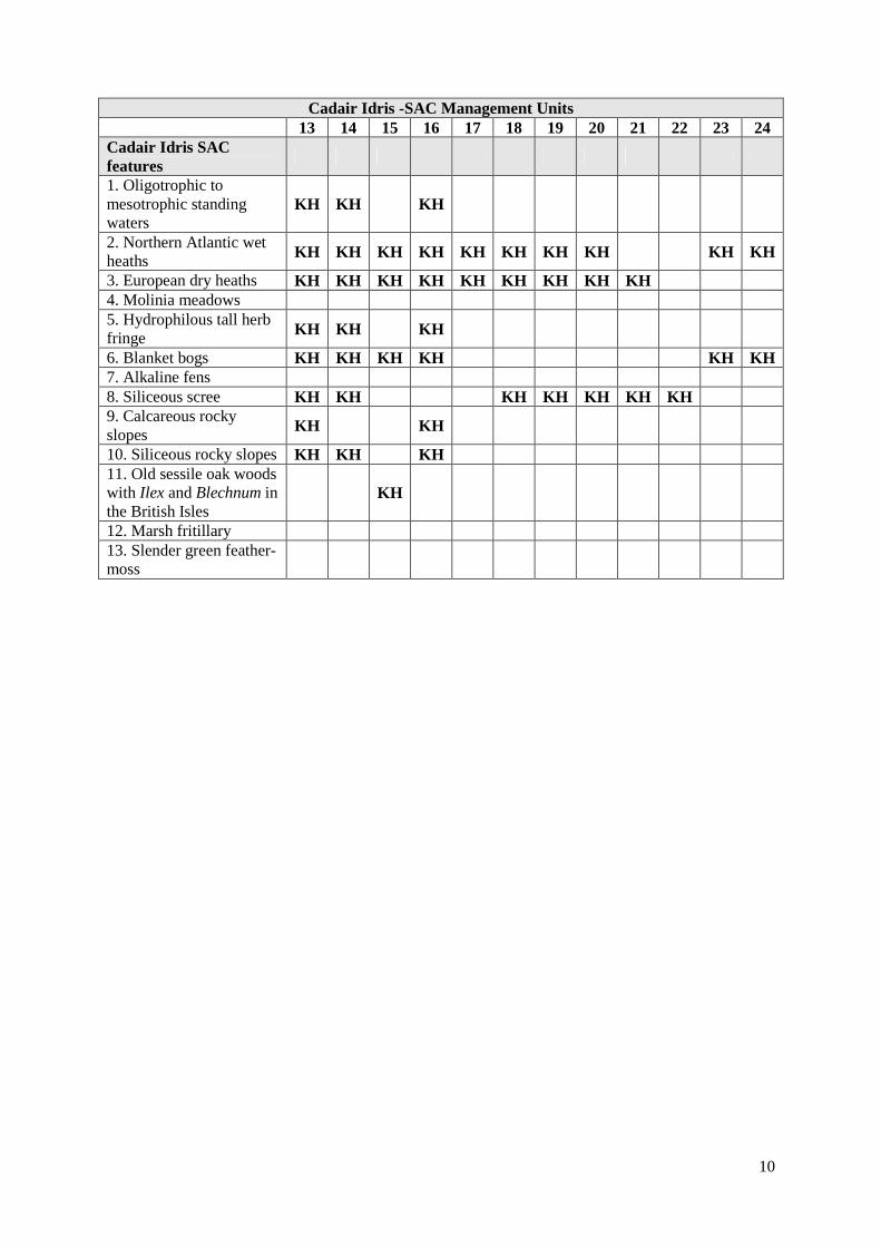
The tables below sets out the relationship between the special features and management units identified in this plan: Because many of the features at Cadair Idris occur in a complex mosaic of communities and intermediate zones between communities, it is more often than not impossible to assign ‘key feature’ status to any one feature. Many of them in any case, such as wet, dry, montane heaths, blanket bogs, peat depressions all generally require the same management and share the same factors. Lakes are always key habitats because of their sensitivity to catchment management including grazing, burning and liming as well as atmospheric nitrogen deposition and acidification. The woodland in the southern part of the mountain and SSSI is included within the Cadair Idris SAC and this plan. Woodland in the north of Cadair SSSI is excluded from the Cadair SAC and is included within the Meirionnydd Oak Woods and Bat sites SAC plan.
Cadair Idris -SAC Management Units 1&4 2 3 5 6 7 8 9 10 11 12 Cadair Idris SAC features 1. Oligotrophic to mesotrophic standing waters KH
2. Northern Atlantic wet heaths KH KH KH KH KH KH KH KH KH 3. European dry heaths KH KH KH KH KH KH KH 4. Molinia meadows KH 5. Hydrophilous tall herb fringe KH KH 6. Blanket bogs KH KH KH KH KH KH KH KH 7. Alkaline fens KH KH 8. Siliceous scree KH KH KH KH 9. Calcareous rocky slopes KH 10. Siliceous rocky slopes KH 11. Old sessile oak woods with Ilex and Blechnum in the British Isles
KH KH
12. Marsh fritillary KS 13. Slender green feather-moss KS
10
Cadair Idris -SAC Management Units
13 14 15 16 17 18 19 20 21 22 23 24 Cadair Idris SAC features
1. Oligotrophic to mesotrophic standing waters
KH KH KH
2. Northern Atlantic wet heaths KH KH KH KH KH KH KH KH KH KH
3. European dry heaths KH KH KH KH KH KH KH KH KH 4. Molinia meadows 5. Hydrophilous tall herb fringe KH KH KH
6. Blanket bogs KH KH KH KH KH KH 7. Alkaline fens 8. Siliceous scree KH KH KH KH KH KH KH 9. Calcareous rocky slopes KH KH
10. Siliceous rocky slopes KH KH KH 11. Old sessile oak woods with Ilex and Blechnum in the British Isles
KH
12. Marsh fritillary 13. Slender green feather-moss

11
Cadair Idris -SAC Management Units
25 26 27 28 29 30 31 32 33 34 35 36 Cadair Idris SAC features
1. Oligotrophic to mesotrophic standing waters
KH
2. Northern Atlantic wet heaths KH KH KH KH KH KH KH KH
3. European dry heaths KH KH KH KH KH KH KH KH KH KH KH KH 4. Molinia meadows 5. Hydrophilous tall herb fringe
6. Blanket bogs KH KH KH KH KH KH 7. Alkaline fens 8. Siliceous scree KH KH KH KH 9. Calcareous rocky slopes
10. Siliceous rocky slopes 11. Old sessile oak woods with Ilex and Blechnum in the British Isles
12. Marsh fritillary 13. Slender green feather-moss

12
Cadair Idris -SAC Management Units
37 38 39 40 Cadair Idris SAC features 1. Oligotrophic to mesotrophic standing waters 2. Northern Atlantic wet heaths KH 3. European dry heaths KH KH KH KH 4. Molinia meadows 5. Hydrophilous tall herb fringe KH KH 6. Blanket bogs KH KH 7. Alkaline fens 8. Siliceous scree KH KH 9. Calcareous rocky slopes 10. Siliceous rocky slopes 11. Old sessile oak woods with Ilex and Blechnum in the British Isles
12. Marsh fritillary 13. Slender green feather-moss
13
4. CONSERVATION OBJECTIVES
Background to Conservation Objectives:
a. Outline of the legal context and purpose of conservation objectives.
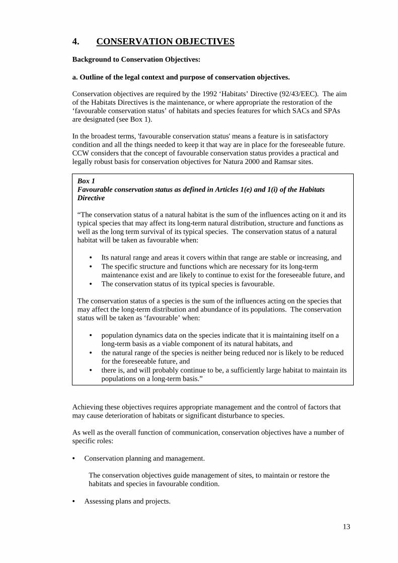
Conservation objectives are required by the 1992 ‘Habitats’ Directive (92/43/EEC). The aim of the Habitats Directives is the maintenance, or where appropriate the restoration of the ‘favourable conservation status’ of habitats and species features for which SACs and SPAs are designated (see Box 1). In the broadest terms, 'favourable conservation status' means a feature is in satisfactory condition and all the things needed to keep it that way are in place for the foreseeable future. CCW considers that the concept of favourable conservation status provides a practical and legally robust basis for conservation objectives for Natura 2000 and Ramsar sites.
Achieving these objectives requires appropriate management and the control of factors that may cause deterioration of habitats or significant disturbance to species. As well as the overall function of communication, conservation objectives have a number of specific roles: • Conservation planning and management.
The conservation objectives guide management of sites, to maintain or restore the habitats and species in favourable condition.
• Assessing plans and projects.
Box 1 Favourable conservation status as defined in Articles 1(e) and 1(i) of the Habitats Directive “The conservation status of a natural habitat is the sum of the influences acting on it and its typical species that may affect its long-term natural distribution, structure and functions as well as the long term survival of its typical species. The conservation status of a natural habitat will be taken as favourable when:
• Its natural range and areas it covers within that range are stable or increasing, and • The specific structure and functions which are necessary for its long-term
maintenance exist and are likely to continue to exist for the foreseeable future, and • The conservation status of its typical species is favourable.
The conservation status of a species is the sum of the influences acting on the species that may affect the long-term distribution and abundance of its populations. The conservation status will be taken as ‘favourable’ when:
• population dynamics data on the species indicate that it is maintaining itself on a
long-term basis as a viable component of its natural habitats, and • the natural range of the species is neither being reduced nor is likely to be reduced
for the foreseeable future, and • there is, and will probably continue to be, a sufficiently large habitat to maintain its
populations on a long-term basis.”

14
Article 6(3) of the ‘Habitats’ Directive requires appropriate assessment of proposed plans and projects against a site's conservation objectives. Subject to certain exceptions, plans or projects may not proceed unless it is established that they will not adversely affect the integrity of sites. This role for testing plans and projects also applies to the review of existing decisions and consents.
• Monitoring and reporting.
The conservation objectives provide the basis for assessing the condition of a feature and the status of factors that affect it. CCW uses ‘performance indicators’ within the conservation objectives, as the basis for monitoring and reporting. Performance indicators are selected to provide useful information about the condition of a feature and the factors that affect it.
The conservation objectives in this document reflect CCW’s current information and understanding of the site and its features and their importance in an international context. The conservation objectives are subject to review by CCW in light of new knowledge. b. Format of the conservation objectives There is one conservation objective for each feature listed in part 3. Each conservation objective is a composite statement representing a site-specific description of what is considered to be the favourable conservation status of the feature. These statements apply to a whole feature as it occurs within the whole plan area, although section 3.2 sets out their relevance to individual management units. Each conservation objective consists of the following two elements:
1. Vision for the feature 2. Performance indicators
As a result of the general practice developed and agreed within the UK Conservation Agencies, conservation objectives include performance indicators, the selection of which should be informed by JNCC guidance on Common Standards Monitoring1. There is a critical need for clarity over the role of performance indicators within the conservation objectives. A conservation objective, because it includes the vision for the feature, has meaning and substance independently of the performance indicators, and is more than the sum of the performance indicators. The performance indicators are simply what make the conservation objectives measurable, and are thus part of, not a substitute for, the conservation objectives. Any feature attribute identified in the performance indicators should be represented in the vision for the feature, but not all elements of the vision for the feature will necessarily have corresponding performance indicators. As well as describing the aspirations for the condition of the feature, the Vision section of each conservation objective contains a statement that the factors necessary to maintain those desired conditions are under control. Subject to technical, practical and resource constraints, factors which have an important influence on the condition of the feature are identified in the performance indicators.
1 Web link: http://www.jncc.gov.uk/page-2199

15
4.1 Conservation Objective for the clear-water lake SAC feature : Oligotrophic to mesotrophic standing waters with vegetation of the Littorelletea uniflorae and/or of the Isoëto-Nanojuncetea (EU 3130) Definition of the feature Cadair Idris SAC includes five oligotrophic lakes, namely Llyn y Gadair, Llyn Gafr, Llyn Arran, Llyn Cyri, and Llyn Cau. Lakes such as these are often vulnerable to acid deposition and nutrient enrichment. Llyn Gafr and Llyn Arran are relatively similar in terms of morphology, macrophyte species composition and their mosaic flora, although ANC values are very different. Llyn Cau is distinct within the Cadair Idris SAC in that it is very deep, with steeply shelving sides and consequently supports lower species diversity and a more marked depth zonation pattern. Llyn Cau also supports a population of Brown Trout, although it is not known whether these fish have been stocked.
SAC Features: Lakes - Oligotrophic to mesotrophic Unit No. ISIS
ref. Lake name
Llyn y Gadair Llyn Gafr Llyn Arran Llyn Cyri Llyn Cau
Vision for Clear-water lakes Feature The vision for the oligotrophic to mesotrophic (clear-water) lakes SAC features is for them to be in a favourable conservation status, where all of the following conditions are satisfied: 1 The total extent of the clear-water lakes shall be maintained as indicated on Map, including open
water/swamp and immediate lake basin visible on air photographs. The catchments should also be maintained in at least their current condition.
2 The location of the clear-water lakes will be as shown on Map and as referred to by name in the
table below. 3 The typical species, as listed following, of the vegetation communities comprising the clear-
water lakes SAC feature will be common. Refer to table 1.
The vegetation community is characterised by amphibious short perennial vegetation, with shoreweed Littorella uniflora, water lobelia Lobelia dortmanna and quillworts Isoetes spp. being the defining components. On Cadair Idris these speceis occur in association with bog pondweed Potamogeton polygonifolius, bulbous rush Juncus bulbosus, alternate water milfoil Myriophyllum alterniflorum, the stonewort Nitella flexilis and floating water bur-reed Sparganium angustifolium.
4 Invasive non-native species are absent 5 All factors affecting the achievement of these conditions are under control.

16
Table 1: Typical species of Cadair Clear-water lakes Llyn Cau Gafr Arran Y Gadair Cyri Isoetes lacustris A A D � Callitriche hamulata A D Littorella uniflora A D � Lobelia dortmanna O D Juncus bulbosus F D Juncus bulbosus var. fluitans � Potamogeton polygonifolius O F P. natans F Myriophyllum alterniflorum A F � Sparganium angustifolium R F � Fontinalis antipyretica O Sphagnum auriculatum O Sphagnum sp. F Nitella flexilis (agg) O Equisetum fluviatile � Rhytidiadelphus squarrosus O Nardia compressa F Zygnema sp. algae � DAFOR rating from CCW contract science report 705 Burgess/Goldsmith/Hatton-Ellis 2006, or �recorded elsewhere Performance indicators for clear-water SAC Feature
The performance indicators are part of the conservation objective, not a substitute for it. Assessment of plans and projects must be based on the entire conservation objective, not just the performance indicators.
Performance indicators for feature condition: lakes Attribute Attribute rationale and other comments Specified limits A1. Extent Lower limit is based on current extent Lower limit: current. A2. Location of clear-water and peaty lakes
A3. Typical species Characteristic species will be frequent in each of the clear-water lakes.
Lower Limit: as present.
A4. Invasive non-native species
Non-native species are undesirable and can out compete native species. Species of water weed such as Canadian pondweed and birds e.g Canada geese may be an issue in the future.
Lower Limit: none present
A5. Water Quality: Nutrient levels
Phosphorus (P) and nitrogen (N) are important plant nutrients controlling growth. In naturally nutrient-poor lakes such as Rhinog these should be at barely detectable levels.
Lower Limit: None set Upper Limit: Mean annual total phosphorus (TP) <10 microgrammes / litre
A6. Water Quality: Water clarity
Lakes within Cadair Idris SAC have clear water as a result of their low nutrient levels and lack of intensive agriculture / forestry in their catchments.
Lower Limit: No decline in max depth of plant colonization Upper Limit: None Set
A8. Water Quality: Acid Neutralising Capacity
Cadair Idris lakes are naturally low in calcium, but are very susceptible to acidification as a result.
Lower Limit: Acid Neutralizing Capacity >20. Upper Limit: None set
17
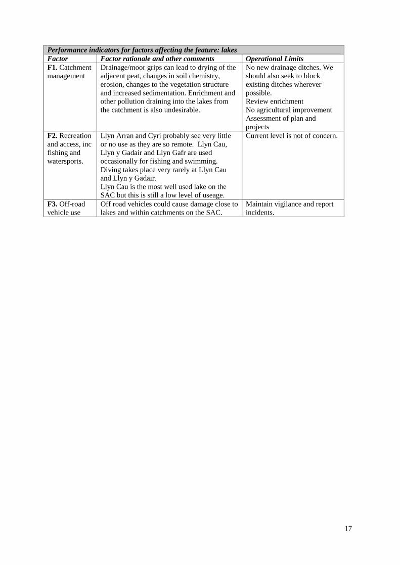
Performance indicators for factors affecting the feature: lakes Factor Factor rationale and other comments Operational Limits F1. Catchment management
Drainage/moor grips can lead to drying of the adjacent peat, changes in soil chemistry, erosion, changes to the vegetation structure and increased sedimentation. Enrichment and other pollution draining into the lakes from the catchment is also undesirable.
No new drainage ditches. We should also seek to block existing ditches wherever possible. Review enrichment No agricultural improvement Assessment of plan and projects
F2. Recreation and access, inc fishing and watersports.
Llyn Arran and Cyri probably see very little or no use as they are so remote. Llyn Cau, Llyn y Gadair and Llyn Gafr are used occasionally for fishing and swimming. Diving takes place very rarely at Llyn Cau and Llyn y Gadair. Llyn Cau is the most well used lake on the SAC but this is still a low level of useage.
Current level is not of concern.
F3. Off-road vehicle use
Off road vehicles could cause damage close to lakes and within catchments on the SAC.
Maintain vigilance and report incidents.

18
4.2 Conservation Objective for Feature : Siliceous Scree Siliceous scree of the montane to snow levels (Androsacetalia alpinae and Galeopsietalia ladani) (EU Habitat Code: 8110) NVC U21: Cryptogramma crispa – Deschampsia flexuosa community Definition of the feature Scree habitats consist of rock fragments covering the frost-shattered summits of mountains or accumulating on slopes below cliffs. Siliceous screes are made up of siliceous rocks such as quartzite, granite and sandstone. Much of the rock is dry and unstable, but on the extensive screes on steep slopes U21 Cryptogramma crispa – Deschampsia flexuosa vegetation is well-distributed, and on the boulder screes, lemon-scented fern Oreopteris limbosperma can be found together with a range of characteristic bryophytes and lichens. Vision for siliceous scree The vision for this feature is for it to be in a favourable conservation status, where all of the following conditions are satisfied:
1. The total extent of the vegetated scree should be maintained. 2. The scree vegetation should be made up primarily of either desirable species listed in the table
below or by other lichen and bryophyte dominated communities characteristic of mobile scree 3. The scree should be mobile and open and free from bracken, tree and scrub species such as
birch Betula and rowan. 4. All factors affecting the achievement of these conditions are under control.
Typical species of scree NVC Classification Typical Species-constants and/or desirable* U21 Cryptogramma crispa – Deschampsia flexuosa community and other forms not described by the NVC plus other lichen and bryophyte dominated communities not covered.
Cryptogramma crispa, Oreopteris limbosperma, Hymenophyllum wilsonii.
19
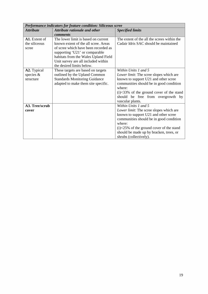
Performance indicators for feature condition: Siliceous scree Attribute Attribute rationale and other
comments Specified limits
A1. Extent of the siliceous scree
The lower limit is based on current known extent of the all scree. Areas of scree which have been recorded as supporting ‘U21’ or comparable habitats from the Wales Upland Field Unit survey are all included within the desired limits below.
The extent of the all the screes within the Cadair Idris SAC should be maintained
A2. Typical species & structure
These targets are based on targets outlined by the Upland Common Standards Monitoring Guidance adapted to make them site specific.
Within Units 1 and 5 Lower limit: The scree slopes which are known to support U21 and other scree communities should be in good condition where: (i)<33% of the ground cover of the stand should be free from overgrowth by vascular plants.
A3. Tree/scrub cover
Within Units 1 and 5 Lower limit: The scree slopes which are known to support U21 and other scree communities should be in good condition where: (i)<25% of the ground cover of the stand should be made up by bracken, trees, or shrubs (collectively).
20
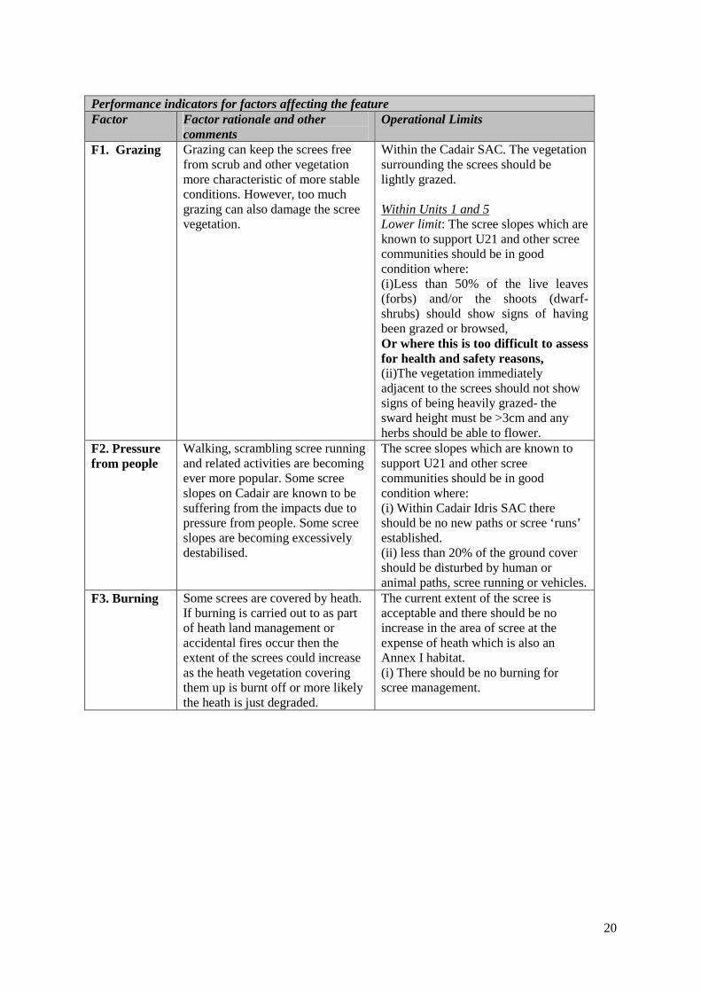
Performance indicators for factors affecting the feature Factor Factor rationale and other
comments Operational Limits
F1. Grazing Grazing can keep the screes free from scrub and other vegetation more characteristic of more stable conditions. However, too much grazing can also damage the scree vegetation.
Within the Cadair SAC. The vegetation surrounding the screes should be lightly grazed. Within Units 1 and 5 Lower limit: The scree slopes which are known to support U21 and other scree communities should be in good condition where: (i)Less than 50% of the live leaves (forbs) and/or the shoots (dwarf-shrubs) should show signs of having been grazed or browsed, Or where this is too difficult to assess for health and safety reasons, (ii)The vegetation immediately adjacent to the screes should not show signs of being heavily grazed- the sward height must be >3cm and any herbs should be able to flower.
F2. Pressure from people
Walking, scrambling scree running and related activities are becoming ever more popular. Some scree slopes on Cadair are known to be suffering from the impacts due to pressure from people. Some scree slopes are becoming excessively destabilised.
The scree slopes which are known to support U21 and other scree communities should be in good condition where: (i) Within Cadair Idris SAC there should be no new paths or scree ‘runs’ established. (ii) less than 20% of the ground cover should be disturbed by human or animal paths, scree running or vehicles.
F3. Burning Some screes are covered by heath. If burning is carried out to as part of heath land management or accidental fires occur then the extent of the screes could increase as the heath vegetation covering them up is burnt off or more likely the heath is just degraded.
The current extent of the scree is acceptable and there should be no increase in the area of scree at the expense of heath which is also an Annex I habitat. (i) There should be no burning for scree management.
21
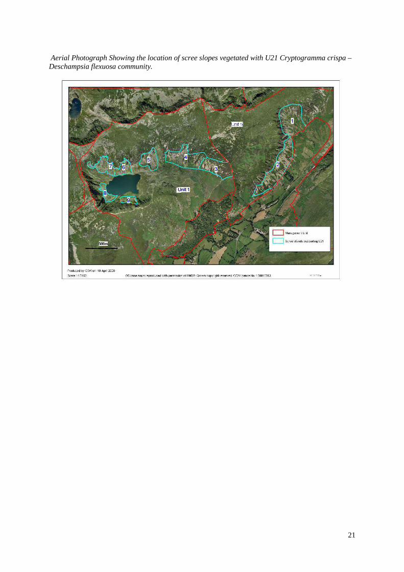
Aerial Photograph Showing the location of scree slopes vegetated with U21 Cryptogramma crispa – Deschampsia flexuosa community.

22
4.3 Conservation Objectives for: Feature; Calcareous rocky slopes with chasmophytic vegetation (Chasmophytic vegetation) (EU Habitat Code: 8210) NVC codes OV39 and OV40 Feature; Siliceous rocky slopes with chasmophytic vegetation (Chasmophytic vegetation) (EU Habitat Code: 8220) NVC codes U21 Feature: Hydrophilous tall herb fringe communities of plains to and of the mountain to alpine level (Tall herb ledges) (EU Habitat Code: 6430) NVC code: U17. Definition of the features Hydrophilous tall herb fringe communities referred to as ‘tall herb ledges’ in this management plan and is incorporated with siliceous and calcareous vegetation in the conservation objectives. This habitat type is typically found on ungrazed upland cliff ledges, occasionally extending on to open ground, and is restricted to base-rich or flushed substrates and somewhat sheltered situations. On Cadair this habitat is normally found on north or east facing cliffs and outcrops. This is one of the few near-natural habitats remaining in Britain and frequently occurs in intimate mosaics with other Annex I habitat types (Calcareous and siliceous chasmophytic vegetation) in these ungrazed, or very lightly grazed, situations. The NVC U17 Luzula sylvatica – Geum rivale tall-herb community is characterised by the abundance of a species-rich mix of tall, broad-leaved herbs, most of which are otherwise rare in the uplands owing to their sensitivity to grazing. These include species such as great wood-rush Luzula sylvatica, wild angelica Angelica sylvestris, roseroot Sedum rosea, wood crane’s-bill Geranium sylvaticum, water avens Geum rivale and globe-flower Trollius europaeus. Calcareous rocky slopes with chasmophytic vegetation. Some forms of the calcareous type correspond to NVC types OV39 Asplenium trichomanes – Asplenium ruta-muraria community and OV40 Asplenium viride – Cystopteris fragilis community, but other forms are not described by the NVC. Chasmophytic vegetation consists of plant communities that colonise the cracks and fissures of rock faces. The type of plant community that develops is largely determined by the base-status of the rock face. Calcareous sub-types develop on lime-rich rocks, whereas siliceous communities develop on acid rocks. The presence of calcareous bands within otherwise mainly siliceous rocks often brings the two types together on the same rock outcrop. Cadair Idris is one of three Welsh sites representing this feature. It has a number of cliffs and rock outcrops with base-rich exposures, with the moist, north-facing cliffs supporting a number of notable bryophytes. Many of the higher plants are clustered below the tall-herb ledge vegetation where water streams down from above and include species such as green spleenwort Asplenium viride. Siliceous rocky slopes with chasmophytic vegetation. The habitat type typically comprises mixtures of bryophytes and vascular plants, such as wavy hair-grass Deschampsia flexuosa and fir clubmoss Huperzia selago. Cadair Idris is one of three Welsh sites representing this feature. Vascular plants include Wilson’s filmy-fern Hymenophyllum wilsonii, starry saxifrage Saxifraga stellaris and fir clubmoss Huperzia selago.
Vision for hydrophilous tall herbs and calcareous and siliceous chasmophytic vegetation The vision for these features is for them to be in a favourable conservation status, where all of the following conditions are satisfied:
1. The total extent of the tall herb ledge and chasmophytic vegetation should be stable or increasing.
2. The tall herb ledges, and chasmophytic vegetation should be made up primarily of the typical and desirable species listed in the table below.
3. Non-native species are absent or rare. 4. All factors affecting the achievement of these conditions are under control.
23
Typical species of the tall herb ledges and chasmophytic vegetation Feature NVC Classification Typical Species-constants and/or desirable* Tall herb ledges NVC
U17 Luzula sylvatica – Geum rivale tall-herb community.
Alchemilla spp*., Angelica sylvestris*, Crepis paludosa* Filipendula ulmaria*, Geranium sylvaticum*, Geum rivale*, Hieracium spp*., Hypericum spp.*, Leucanthumum vulgare*, Luzula sylvatica, Meconopsis cambrica*, Pimpinella saxifraga*, Rumex acetosa, Sedum rosea*, Silene dioica*, Solidago virgaurea*, Succisa pratensis*, Trollius europaeus* Valeriana officinalis*.
Calcareous chasmophytic vegetation NVC
OV39 Asplenium trichomanes – Asplenium ruta-muraria community and OV40 Asplenium viride – Cystopteris fragilis community, and other forms not described by the NVC.
Tortella tortuosa, Anoectangium aestivum and Ctenidium molluscum, Asplenium viride*, Asplenium trichomanes, Saxifraga oppositifolia*, Alchemilla spp.*, Carex pulicaris*, Sedum rosea* and Thymus polytrichus*
Siliceous chasmophytic vegetation
U21 Cryptogramma crispa – Deschampsia flexuosa community and other forms not described by the NVC.
Amphidium mougeotii*, Racomitrium spp., Deschampsia flexuosa, Huperzia selago*, Cryptogramma crispa*, Hymenophyllum wilsonii*, Saxifraga stellaris*, Campanula rotundifolia*, Solidago virgaurea and Blechnum spicant.
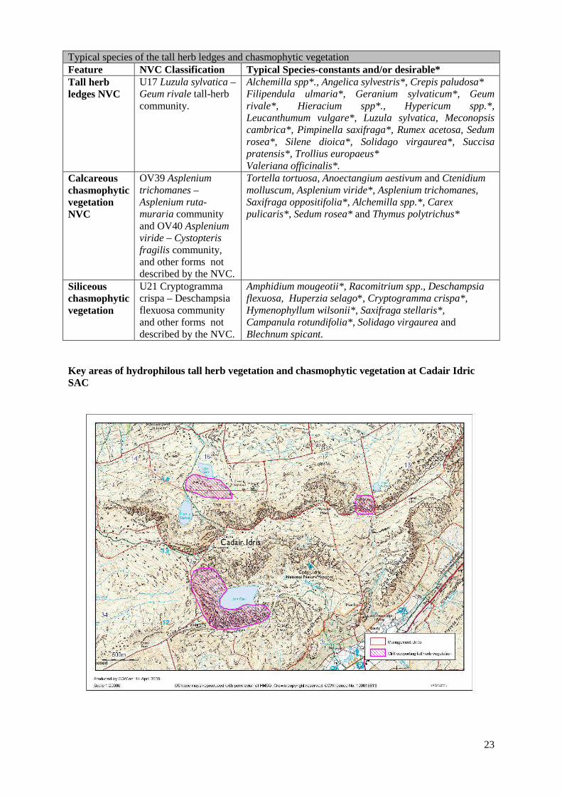
Key areas of hydrophilous tall herb vegetation and chasmophytic vegetation at Cadair Idric SAC
24
Performance indicators for Features: Tall Herb Ledges, and Chasmophytic Vegetation The performance indicators are part of the conservation objective, not a substitute for it. Assessment of plans and projects must be based on the entire conservation objective, not just the performance indicators. Performance indicators for feature condition: Tall herb ledges and chasmophytic vegetation Attribute Attribute rationale and other comments Specified limits A1. Extent of the tall herbs and chasmophytic vegetation
The tall herb ledge vegetation is currently found on cliff ledges and crevices which are mostly inaccessible to grazing animals. However, it is desirable in the long term to extent the tall herb vegetation to it’s full potential. The key areas for these vegetation types are the crags surrounding; Llyn Y Gafr (Units 14 and 16), Llyn Cau (Unit 1) and Llyn Arran (Units 13 and 14) (See map above).Tall herb vegetation has also been recorded in small amounts within Cwm Rhwyddfor (Unit 5) and Mynydd Rugog (U nit 38) and may occur elsewhere on the site. Calcareous and siliceous chasmophytic vegetation may occur on any rocky outcrop on Cadair wherever the climatic or ‘soil’ conditions allow.
Target: The desired extent of the tall herb ledge and chasmophytic vegetation is for it to extend to the lowest ledges and crevices- currently accessible to grazing stock and for the tall herb vegetation to extend to the areas adjacent to the cliff bases wherever the soils allow for this vegetation type to develop. Lower limit: The vegetation should be maintained at the current extent.
A2. Typical species of tall herb ledges and chasmophytic vegetation.
These targets are based on targets outlined by the Uplands Common Standards Monitoring Guidance for tall herb ledges and chasmophytic vegetation. However, they have been adapted to reflect the species composition at Cadair Idris. The tall herb vegetation is variable and may vary from ledge to ledge in terms of the presence and abundance of species. The list of desirable species should be used as a guide, rather than a definitive list of every species which should be present.
Upper limit: Not required Lower limit: The tall herb and chasmophytic vegetation should be in good condition where (i)The rocky outcrops are vegetated with desirable species such as those listed above. (ii)Cover of Nardus stricta, Agrostis capillaris and Anthoxanthum odoratum should be less than 10%.
A3. Tree and shrub species
Bracken, trees or scrub, excluding ericoids, are not desirable.
Upper limit: Not required Lower limit: The tall herb and chasmophytic vegetation should be in good condition where: (i)Less than 25% of the ground cover should be made up of bracken. (ii)Less than 10% should be made up of trees or scrub excluding ericoids.
A4.Non-native species
Non-native species are not present. Upper limit: Not required Lower limit: The tall herb and chasmophytic vegetation should be in good condition where: (ii)Non-native species such

25
as Rhododendron are not present. (iii) The non-native species Epilobium brunnescens makes up less than 1% of the vegetation.

26
Performance indicators for factors affecting the feature Factor, rationale and other comments Operational Limits F1. Grazing The tall herb ledges and chasmophytic vegetation is not maintained by grazing since succession to woodland here has been arrested by soil depth and exposure. Grazing can have a negative influence on the vegetation on the lower and more accessible ledges and crevices. No grazing adjacent is likely to benefit these SAC features.
Grazing levels within the units (1,13, 14 and 16) where tall herbs are a key habitat. Lower limit: (i)At least 50% of the tall herb stems should be >20cm tall or there should be few observable signs of grazing on tell herb, and chasmophytic vegetation and most tall herb species must be flowering or showing signs of being able to flower during the summer months. (ii)Less than 10% of the ground cover should be disturbed bare ground. (iii)The adjacent habitats should be lightly grazed as appropriate -refer to relevant section of this plan e.g. heath.
F2. Hydrological regime. Many of the tall herb ledges are maintained by base rich flushing in terms of both structure and species composition. Flushing can also dictate the species composition of the chasmophytic vegetation. Although much of the chasmophytic vegetation is dry, where the chasmophytic vegetation is dominated by moisture- requiring bryophytes and ferns, it is likely to be dependent on flushing.
(i)Maintain natural drainage-seepage
F3. Climbing Climbing can lead to damage or to the loss of chasmophytic vegetation or tall herb ledges. Very little climbing takes place here as it is not particularly suitable.
Within units 1, 13, 14 and 16: Upper limit: There should be no damage to the tall herb ledge vegetation and chasmophytic vegetation by climbers.
Survey Information for the tall herb and chasmophytic vegetation. These communities are difficult to map in particular the chasmophytic vegetation. No mapping of the chasmophytic vegetation has occurred however, it’s location (rather than extent) can be guessed at since it occurs in rocky areas and the calcareous/siliceous division is dictated by the rock type. Calcareous chasmophytic vegetation is associated with the tall herb ledge vegetation- occurring in the same areas within the smaller ledges and crevices. Siliceous chasmophytic vegetation has the potential to develop on any outcrop across the site. The hydrophilous tall herb communities have been mapped to NVC standard within the NNR, Unit 1 by Averis (2000) and recorded again in detail by Grasse (2002). Tall herb ledges and outcrops with chasmaphytic vegetation were also marked on oblique photographs within the NNR and above Llyn Y Gafr as part of the SAC monitoring in 2003 however, that work was a result of observations of the more obvious outcrops from safe ground and is not the result of a complete and detailed survey. Outside of the NNR the location of the tall herb ledges was noted in the Upland Field Unit Survey (Jackson & Yeo 1991) at Llyn Y Gafr (Unit 14) and Llyn Arran (Units 13,and 14) in addition to some minimal occurrences of this vegetation type within units 5, 37 and 38. However, there was no attempt to accurately map this habitat. Further work needs to be carried out to record the full extent of the tall herb and chasmophytic vegetation.
27
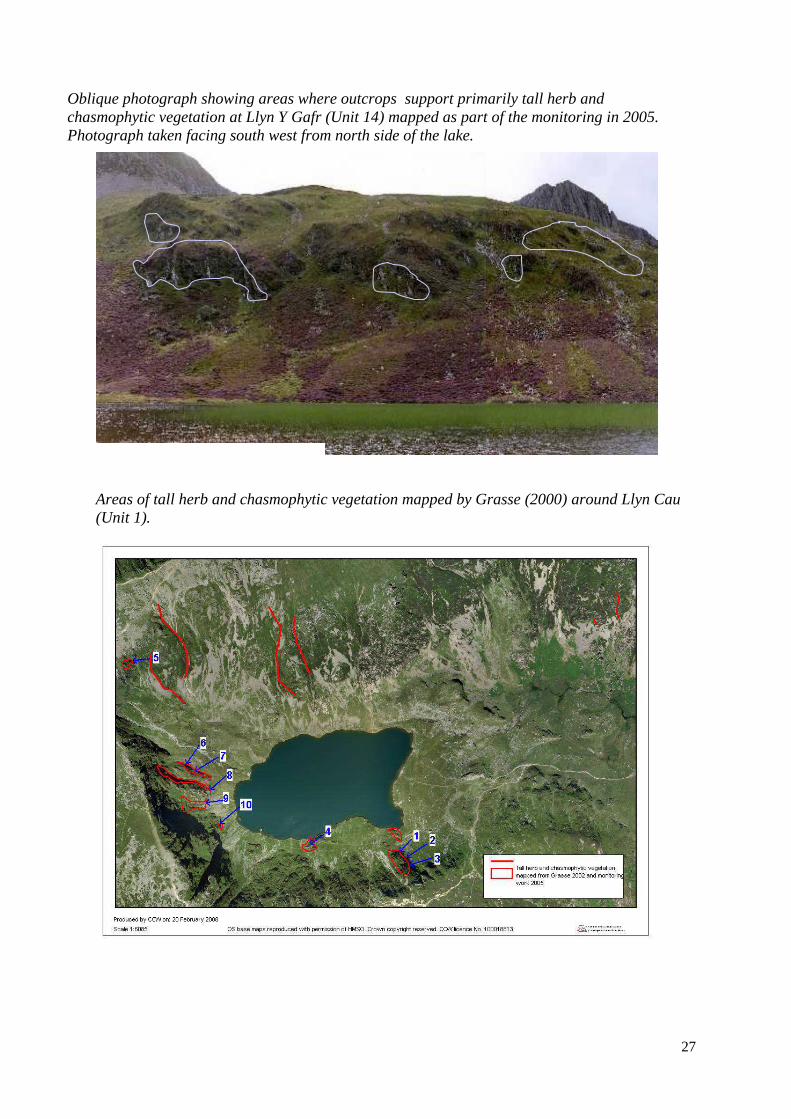
Oblique photograph showing areas where outcrops support primarily tall herb and chasmophytic vegetation at Llyn Y Gafr (Unit 14) mapped as part of the monitoring in 2005. Photograph taken facing south west from north side of the lake.
Areas of tall herb and chasmophytic vegetation mapped by Grasse (2000) around Llyn Cau (Unit 1).

28
Oblique photograph of crags marked 1-3 on the above map. Taken from north showing outcrops mapped as supporting tall herb and chasmophytic vegetation at Cwm Cau (Unit 1) Figure 7. Oblique photograph of crags marked 5-10 on the above photograph, taken from south east, showing outcrops mapped as supporting tall herb and chasmophytic vegetation at Cwm Cau (Unit 1)
5
9
10
8
6
7
1 2 3
29
4.4 Conservation Objectives for the European dry heaths (EU 4030) and Northern Atlantic wet heath with Erica tetralix SAC features (EU 4010)
• Dry Heath- NVC communities: H8, 10, 12, 18, 21. (montane heaths: U10a moss heath & wind-
pruned Calluna heath) • Wet Heath- NVC communities: M15 Vision for heath SAC Features The vision for the heath land SAC features is for them to be in a favourable conservation status, where all of the following conditions are satisfied: 1 The total extent of the dry heath ,approximately 1451 ha, shall at least be maintained . The
currently unfavourable areas of dry heath and acid grassland capable of restoration should be managed under a restoration programme. The area of dry heath should increase at the expense of less desirable vegetation communities such as acid grassland. The total extent of the wet heath , approximately 239 ha, shall at least be maintained. The area of wet heath should increase overall at the expense of less desirable vegetation communities. Some areas of wet heath which are degraded blanket bog may be restored to that priority habitat provided that there is no net loss of wet heath within the SAC.
2 The distribution of the dry and wet heath will at least be as mapped in Gray( 2003) & Averis (2000) and will preferably be increasing as it is restored in additional areas.
3 The typical species of the vegetation communities comprising the dry heath and wet heath will be
frequent and abundant. See Table 1. 4 The abundance and distribution of uncommon plants (see Table 2) will be maintained or
increased. 5 The structure of the heath should be maintained and restored, to show natural regeneration by
layering and seeding, and to ensure that the component vegetation communities are naturally diverse (refer also to 3 and 4 above). In practise some stands will benefit from being taller with very mature heather (e.g NVC H 21) and others including wet heath from having a medium to short structure, less than 30cms height. Signs of overgrazing, including ‘suppressed’, ‘topiary’ or ‘drumstick’ growth habits will not be apparent.
6 Invasive non-native species such as conifers, rhododendron, Japanese knotweed and Himalayan
balsam will not be present. 7 The surface of the heath will be generally free from trees and at most have only a few individuals
at a density of no more than 2 per hectare. Exceptions to this rule are transition zones from woodland to heath land where trees may be denser grading to open heath. Limits for woodland transition zones should be set on a unit or sub-unit basis.
8 All factors affecting the achievement of these conditions are under control.
30
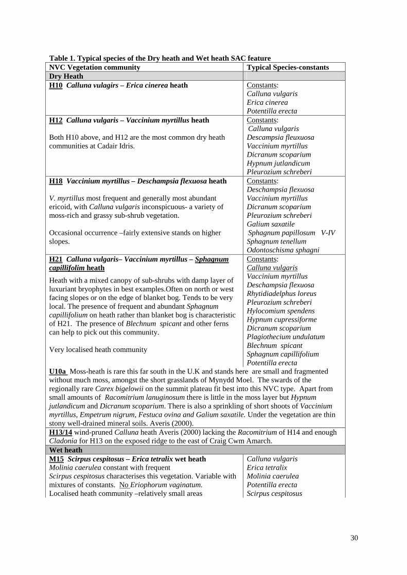
Table 1. Typical species of the Dry heath and Wet heath SAC feature NVC Vegetation community Typical Species-constants Dry Heath H10 Calluna vulagirs – Erica cinerea heath
Constants: Calluna vulgaris Erica cinerea Potentilla erecta
H12 Calluna vulgaris – Vaccinium myrtillus heath Both H10 above, and H12 are the most common dry heath communities at Cadair Idris.
Constants: Calluna vulgaris Descampsia fleuxuosa Vaccinium myrtillus Dicranum scoparium Hypnum jutlandicum Pleurozium schreberi
H18 Vaccinium myrtillus – Deschampsia flexuosa heath V. myrtillus most frequent and generally most abundant ericoid, with Calluna vulgaris inconspicuous- a variety of moss-rich and grassy sub-shrub vegetation. Occasional occurrence –fairly extensive stands on higher slopes.
Constants: Deschampsia flexuosa Vaccinium myrtillus Dicranum scoparium Pleurozium schreberi Galium saxatile Sphagnum papillosum V-IV Sphagnum tenellum Odontoschisma sphagni
H21 Calluna vulgaris– Vaccinium myrtillus – Sphagnum capillifolim heath
Heath with a mixed canopy of sub-shrubs with damp layer of luxuriant bryophytes in best examples.Often on north or west facing slopes or on the edge of blanket bog. Tends to be very local. The presence of frequent and abundant Sphagnum capillifolium on heath rather than blanket bog is characteristic of H21. The presence of Blechnum spicant and other ferns can help to pick out this community. Very localised heath community
Constants: Calluna vulgaris Vaccinium myrtillus Deschampsia flexuosa Rhytidiadelphus loreus Pleurozium schreberi Hylocomium spendens Hypnum cupressiforme Dicranum scoparium Plagiothecium undulatum Blechnum spicant Sphagnum capillifolium Potentilla erecta
U10a Moss-heath is rare this far south in the U.K and stands here are small and fragmented without much moss, amongst the short grasslands of Mynydd Moel. The swards of the regionally rare Carex bigelowii on the summit plateau fit best into this NVC type. Apart from small amounts of Racomitrium lanuginosum there is little in the moss layer but Hypnum jutlandicum and Dicranum scoparium. There is also a sprinkling of short shoots of Vaccinium myrtillus, Empetrum nigrum, Festuca ovina and Galium saxatile. Under the vegetation are thin stony well-drained mineral soils. Averis (2000). H13/14 wind-pruned Calluna heath Averis (2000) lacking the Racomitrium of H14 and enough Cladonia for H13 on the exposed ridge to the east of Craig Cwm Amarch. Wet heath M15 Scirpus cespitosus – Erica tetralix wet heath Molinia caerulea constant with frequent Scirpus cespitosus characterises this vegetation. Variable with mixtures of constants. No Eriophorum vaginatum. Localised heath community –relatively small areas
Calluna vulgaris Erica tetralix Molinia caerulea Potentilla erecta Scirpus cespitosus

31
Table 2: Uncommon plants of the heath features Species Status Notes-guide to presence in NVC
communities Carex bigelowii Regionally Rare H18, H21, Montane heath U10 Listera cordata Locally uncommon H12, H21 Salix herbacea Regionally Rare Montane heath U10
Performance indicators for the dry and wet heath SAC Features The performance indicators are part of the conservation objective, not a substitute for it. Assessment of plans and projects must be based on the entire conservation objective, not just the performance indicators. More detail on factors and management is given in section 5 of this plan. Performance indicators for features condition: heath Attribute Attribute rationale and other comments Specified limits A1. Extent of heath
Lower limit is based on current extent of dry and wet heath estimated c.45% cover (1690 ha). Dry heath currently covers c.38% of the site (1451ha), and wet heath covers c.6% (239 ha) of the site. Also recorded at Cadair Idris –on the NNR- are the montane communities of wind-pruned Calluna heath(to the east of Craig Cwm Amarch), and Carex bigelowii-Racomitrium lanuginosum moss-heath community U10a(Mynydd Moel).
Lower limit: maintain current extent, including montane heath. Upper limit: None, as defined by geology, soils and topography and provided expansion is at the expense of less desirable vegetation such as acid grassland. Aim to increase especially localised communities such as montane heath There is some scope for expansion of the U10a community, at the expense of adjacent areas of acid grassland U4e.
A2. Distribution of heath
The heathland communities as described should be stable or increasing in distribution.
Maintain current distribution, and aim to increase distribution of montane heath on the Penygadair-Mynydd Moel plateau.
A3. Typical species
The typical species of the vegetation communities comprising the dry heath and wet heath will be frequent and abundant. See Table 1. less desirable species such as Juncus squarrosus will be infrequent
The NVC Rodwell (1991) and especially the site-specific quadrats Averis (2000) are a guide to expected lower limit frequencies of desirable species.
A4. Uncommon plants
Current populations of uncommon plants will flourish and expand where possible.
Upper Limit: none set Lower Limit: as recorded Averis (2000) and subsequently.
A5. Heath land structure
The heath surface should be regenerating and characteristic of the vegetation community and generally at a height where there is the most plant diversity.
Set limits relevant to particular location/stand in context of whole site.
A6. Non-native species
Non-native species especially invasive species such as conifers, rhododendron, Japanese knotweed and Himalayan balsam should not be present.
Acceptable limit: None present within SAC. Target: None present within species specific buffer zones around SAC
32
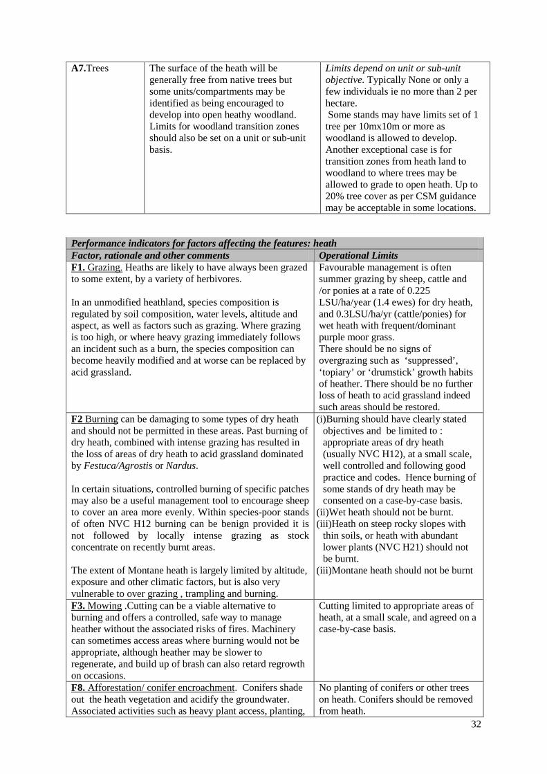
A7.Trees The surface of the heath will be
generally free from native trees but some units/compartments may be identified as being encouraged to develop into open heathy woodland. Limits for woodland transition zones should also be set on a unit or sub-unit basis.
Limits depend on unit or sub-unit objective. Typically None or only a few individuals ie no more than 2 per hectare. Some stands may have limits set of 1 tree per 10mx10m or more as woodland is allowed to develop. Another exceptional case is for transition zones from heath land to woodland to where trees may be allowed to grade to open heath. Up to 20% tree cover as per CSM guidance may be acceptable in some locations.
Performance indicators for factors affecting the features: heath Factor, rationale and other comments Operational Limits F1. Grazing. Heaths are likely to have always been grazed to some extent, by a variety of herbivores. In an unmodified heathland, species composition is regulated by soil composition, water levels, altitude and aspect, as well as factors such as grazing. Where grazing is too high, or where heavy grazing immediately follows an incident such as a burn, the species composition can become heavily modified and at worse can be replaced by acid grassland.
Favourable management is often summer grazing by sheep, cattle and /or ponies at a rate of 0.225 LSU/ha/year (1.4 ewes) for dry heath, and 0.3LSU/ha/yr (cattle/ponies) for wet heath with frequent/dominant purple moor grass. There should be no signs of overgrazing such as ‘suppressed’, ‘topiary’ or ‘drumstick’ growth habits of heather. There should be no further loss of heath to acid grassland indeed such areas should be restored.
F2 Burning can be damaging to some types of dry heath and should not be permitted in these areas. Past burning of dry heath, combined with intense grazing has resulted in the loss of areas of dry heath to acid grassland dominated by Festuca/Agrostis or Nardus. In certain situations, controlled burning of specific patches may also be a useful management tool to encourage sheep to cover an area more evenly. Within species-poor stands of often NVC H12 burning can be benign provided it is not followed by locally intense grazing as stock concentrate on recently burnt areas. The extent of Montane heath is largely limited by altitude, exposure and other climatic factors, but is also very vulnerable to over grazing , trampling and burning.
(i)Burning should have clearly stated objectives and be limited to : appropriate areas of dry heath (usually NVC H12), at a small scale, well controlled and following good practice and codes. Hence burning of some stands of dry heath may be consented on a case-by-case basis.
(ii)Wet heath should not be burnt. (iii)Heath on steep rocky slopes with
thin soils, or heath with abundant lower plants (NVC H21) should not be burnt.
(iii)Montane heath should not be burnt
F3. Mowing .Cutting can be a viable alternative to burning and offers a controlled, safe way to manage heather without the associated risks of fires. Machinery can sometimes access areas where burning would not be appropriate, although heather may be slower to regenerate, and build up of brash can also retard regrowth on occasions.
Cutting limited to appropriate areas of heath, at a small scale, and agreed on a case-by-case basis.
F8. Afforestation/ conifer encroachment. Conifers shade out the heath vegetation and acidify the groundwater. Associated activities such as heavy plant access, planting,
No planting of conifers or other trees on heath. Conifers should be removed from heath.
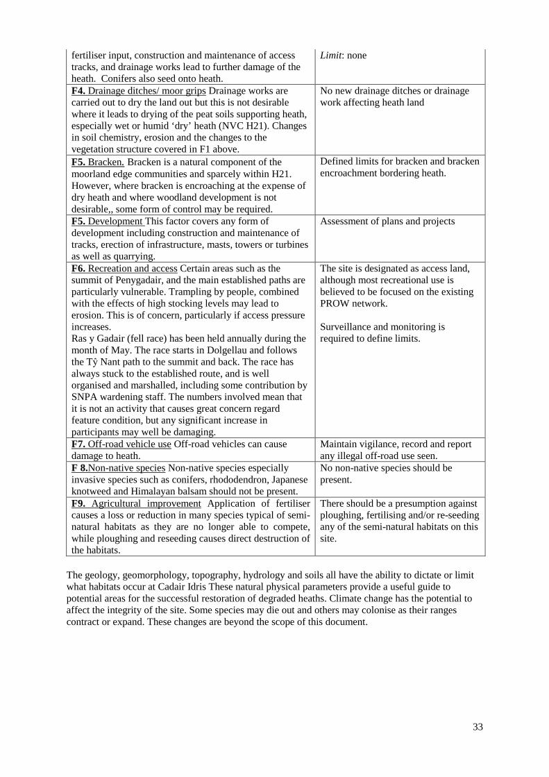
33
fertiliser input, construction and maintenance of access tracks, and drainage works lead to further damage of the heath. Conifers also seed onto heath.
Limit: none
F4. Drainage ditches/ moor grips Drainage works are carried out to dry the land out but this is not desirable where it leads to drying of the peat soils supporting heath, especially wet or humid ‘dry’ heath (NVC H21). Changes in soil chemistry, erosion and the changes to the vegetation structure covered in F1 above.
No new drainage ditches or drainage work affecting heath land
F5. Bracken. Bracken is a natural component of the moorland edge communities and sparcely within H21. However, where bracken is encroaching at the expense of dry heath and where woodland development is not desirable,, some form of control may be required.
Defined limits for bracken and bracken encroachment bordering heath.
F5. Development This factor covers any form of development including construction and maintenance of tracks, erection of infrastructure, masts, towers or turbines as well as quarrying.
Assessment of plans and projects
F6. Recreation and access Certain areas such as the summit of Penygadair, and the main established paths are particularly vulnerable. Trampling by people, combined with the effects of high stocking levels may lead to erosion. This is of concern, particularly if access pressure increases. Ras y Gadair (fell race) has been held annually during the month of May. The race starts in Dolgellau and follows the Tŷ Nant path to the summit and back. The race has always stuck to the established route, and is well organised and marshalled, including some contribution by SNPA wardening staff. The numbers involved mean that it is not an activity that causes great concern regard feature condition, but any significant increase in participants may well be damaging.
The site is designated as access land, although most recreational use is believed to be focused on the existing PROW network. Surveillance and monitoring is required to define limits.
F7. Off-road vehicle use Off-road vehicles can cause damage to heath.
Maintain vigilance, record and report any illegal off-road use seen.
F 8.Non-native species Non-native species especially invasive species such as conifers, rhododendron, Japanese knotweed and Himalayan balsam should not be present.
No non-native species should be present.
F9. Agricultural improvement Application of fertiliser causes a loss or reduction in many species typical of semi-natural habitats as they are no longer able to compete, while ploughing and reseeding causes direct destruction of the habitats.
There should be a presumption against ploughing, fertilising and/or re-seeding any of the semi-natural habitats on this site.
The geology, geomorphology, topography, hydrology and soils all have the ability to dictate or limit what habitats occur at Cadair Idris These natural physical parameters provide a useful guide to potential areas for the successful restoration of degraded heaths. Climate change has the potential to affect the integrity of the site. Some species may die out and others may colonise as their ranges contract or expand. These changes are beyond the scope of this document.
34
4.5 Conservation Objective for SAC feature : Blanket Bog (EU 7130) Comprising bog pools and blanket mire of the following National Vegetation Classification (NVC) communities: - M1, M2, M3, 17, 18, 19 & 20 Vision for the blanket bog SAC feature The vision for this priority blanket bog SAC feature is for it to be in a favourable conservation status, where all of the following conditions are satisfied: 1. The total extent of the blanket bog area is stable at some 200 ha in total of NVC blanket bog
communities and some 73ha of vegetation on deep peat (Gray 2003), or increasing. Vegetation mapped as NVC M20, or not recognisable as a blanket bog community, is always considered to be unfavourable. The area of the blanket bog feature is increasing at the expense of less desirable vegetation communities or if wet heath is restored to blanket bog commensurate areas of land are gained to wet heath.
2. The location and distribution of the blanket bog is increasing at the expense of less desirable
vegetation communities. 3. The typical species of the vegetation communities comprising the blanket bog SAC feature are
frequent. Refer to Table 1. 4. The structure of the blanket bog is maintained and restored to include bog pools, depressions,
hummocks and hollows as a natural feature of the bog surface. Artificial drainage ditches or moor grips are not present as functioning drains. No significant areas of peat erosion should be present.
5. Invasive non-native species such as conifers, rhododendron, Japanese knotweed and Himalayan
balsam are not present within the SAC and a species specific buffer area. 6. The blanket bog is free from all trees. 7. All factors affecting the achievement of these conditions are under control. Table 1. Typical species of the Blanket Bog SAC feature NVC Vegetation community Typical Species-constants and/ or desirable* Bog Pools M1 Sphagnum denticulatum bog pool community Eriophorum angustifolium
Menyanthes trifoliata Sphagnum auriculatum Sphagnum cuspidatum
M2 Sphagnum cuspidatum/Sphagnum recurvum bog pool community.
Erica tetralix Eriophorum angustifolium Drosera rotundifolia Sphagnum recurvum Rhynchospora alba
M3 Eriophorum angustifolium bog pool community.
Eriophorum angustifolium
Blanket Mire M17Trichophorum cespitosum-Eriophorum vaginatum blanket mire. Characteristically frequent Eriophorum vaginatum, Scirpus cespitosus and Molinia caerulea.
Calluna vulgaris Erica tetralix Eriophorum angustifolium Eriophorum vaginatum Molinea caerulea Narthecium ossifragum Potentilla erecta
35
Scirpus cespitosus Sphagnum capillifolium Sphagnum papillosum Vaccinium vitis-idaea*
M19 Calluna vulgaris –Eriophorum vaginatum blanket mire.
Sphagnum papillosum (I-II)
Calluna vulgaris Eriophorum angustifolium Eriophorum vaginatum Sphagnum capillifolium Vaccinium vitis-idaea* Empetrum nigrum*
M20 Eriophorum vaginatum raised and blanket mire. Poor ombrogenous bog vegetation dominated by Eriophorum vaginatum tussocks.
Eriophorum angustifolium Eriophorum vaginatum
Performance indicators for Blanket bog SAC Feature The performance indicators are part of the conservation objective, not a substitute for it. Assessment of plans and projects must be based on the entire conservation objective, not just the performance indicators. Performance indicators for feature condition: Blanket Bog Attribute, rationale and other comments Specified limits where
appropriate A1. Extent of blanket bog Lower limit is based on the current extent which must be maintained. The full extent is difficult to measure precisely as degraded blanket bog does not support characteristic blanket bog vegetation. The area given can only be regarded as approximate. The area of blanket bog should be increasing through restoration management.
Lower limit: c.273 ha ie current area. Land must be checked for this feature before any assessment takes place. No blanket bog area can be lost. Upper limit: None, naturally limited by geology, topography and rainfall.
A2. Location and distribution of blanket bog The current location and distribution within the SAC must be maintained.
As current or increasing good quality blanket bog
A3. Typical species Typical species will be frequent and form the main dominants. Refer to table 1.
As guide to frequency refer to NVC tables and averis (2000) quadrats.
A4. Bog surface structure The structure of the blanket bog is maintained and restored to include bog pools, depressions, hummocks and hollows as a natural feature of the bog surface. Artificial drainage ditches or moor grips are not present as functioning drains. Ditches should be in filled or blocked to create pools. There should be no significant peat erosion.
Limit: To be defined as a pragmatic proportion of the current mapped drains including those which will infill and re-vegetate naturally over time.
A5. Invasive non-native species Invasive non-native species are aliens within the natural blanket bog communities. Their invasive nature means they threaten the integrity of the habitat by competition, shading and often drying of the blanket bog by transpiration. Blanket bog area as in A1 and A2 is lost unless control takes place.
None present within SAC and ‘buffer’ surrounding land for 1km.
A6. Tree cover Blanket bog in Wales has been naturally tree-less for a long time. Trees are present occasionally where this habitat is in mosaic on drier areas such as heath and acid grassland or
Blanket bog in favourable condition is tree less.

36
crags away from grazing stock. Blanket bog that has been drained, and planted with conifers and is then cleared or fails is particularly prone to tree regeneration.
Performance indicators for factors affecting the feature: Blanket Bog Factor, rationale and other comments Operational Limits F1. Grazing Blanket bogs are likely to have always been grazed to some extent, by a variety of herbivores. In an unmodified blanket bog, species composition is regulated by the rain water input and a naturally high water table. Without interference and within high rainfall areas the surface of the bog grows upwards, forming hummocks and hollows as peat continually forms. This natural blanket bog has a low fairly constant vegetation height with a mattress of heather and other woody shrubs over a lower layer of Eriophorum vaginatum. If, as is often the case, the bog is modified, for example by gripping, burning or heavy grazing, the ‘natural’ system becomes unbalanced. Hence drained and/ or burnt blanket bog tends to have a greater dominance of heather which can become leggy. This can lead to perceived problems of stock access, and calls for further burning or draining to remedy this; resulting in a downward spiral. In the short term, it may be possible to achieve widespread stock dispersal by mowing non blanket bog vegetation areas/paths and to restore the naturally high water table by infilling and/or blocking drains. Overgrazing, often with burning, will degrade blanket bog from the better communities to NVC M20 and then to acid /marshy grassland unless restoration measures are put in place.
Favourable management is often summer grazing by sheep, cattle and /or ponies at a rate of 0.05 LSU/ha/year. (0.33 ewes) Ponies or cattle have advantages over sheep due to their tendency to graze coarser grass and rush vegetation without adversely affecting heather/ericaeous cover. Sheep will graze heather intensively in the autumn/winter.
F2 Burning Blanket bog should not be burnt, as burning damages important plant and animal species, especially bog mosses and invertebrates and interferes with the natural development of this vegetation. Past burning practice is likely to be at least partly responsible for the relative rarity of burning-sensitive species. Burning, in combination with intense grazing, is also responsible for damage and loss of areas of blanket bog in the site. Burns scorch and kill bog mosses such as Sphagnum capillifolium and S.papillosum and other lower plants, removing the heather/ericaeous layer, to reveal the blanket of Eriophorum vaginatum underneath. The cotton grass recovers well from fire, enjoys the ‘fertiliser’ input of ash, and has then a competitive advantage over other plants which can only recolonise slowly. Thus a NVC M19 or 17 bog is converted to the degraded NVC M20 and becomes unfavourable.
No burning
F4. Drainage ditches/ moor grips The wetland habitats and features are profoundly influenced by alterations to the natural drainage regime of the site. Blanket bog is a nutrient-poor system, which arises in areas with a wet, cool climate and a suitable topography (level or gently sloping ground) with little or no water flowing in from surrounding land. Artificial drains cause the bog to dry out and to deteriorate adjacent to the drains. The drains may bring nutrients to the system and the vegetation changes because the bog is no longer only receiving nutrients from the rain. Also, if the drying peat surface becomes exposed, it then oxidises which releases nutrients into the system. This results in similar changes to the sensitive vegetation as well as increased peat erosion. For these reasons, it is important that there should be no new drainage ditches dug in this habitat, and wherever possible old drainage ditches should
No new drainage ditches. We should also seek to infill/block existing ditches wherever possible and to have targets for restoration.
37
be blocked or encouraged to infill. This habitat forms a natural sponge which, provided it is not ditched, helps to reduce floods lower down the river system in rainy times while providing plenty of water during summer droughts. F6. Recreation and access The SAC is designated as access land, although most recreational use is believed to be focused on or close to the existing PROW network. Access can cause erosion and compaction and lead to pressure for infra-structure which can damage or destroy parts of the blanket bog if sited on it.
No significant erosion or compaction of blanket bog and no infrastructure on this priority habitat. No erosion at all in vulnerable locations.
F7. Off-road vehicle use This feature is vulnerable to significant damage should off-roading become a problem, and it is therefore discouraged. Off road vehicles can cause erosion and compaction and lead to pressure for new routes which can damage or destroy parts of the blanket bog if sited on it or immediately adjacent.
Maintain vigilance, record and report any illegal off-road use seen. No new routes on or very near blanket bog.
F8. Afforestation/ conifer encroachment The presence of trees/conifers on blanket bog immediately places the conservation status of the bog as ‘unfavourable’. Afforestation with the accompanying ditching and track construction has damaged blanket bog in the past and continues to cause degradation. The drains continue to function, causing drying of the bog and direct damage/loss of blanket bog vegetation to ditch and spoil. Conifer/trees adjacent and on the blanket bog provide a seed-source for further encroachment, as well as continuing to dry the bog through transpiration.
The blanket bog should be treeless. No new afforestation or tree planting on blanket bog. (Trees may be acceptable on neighbouring habitats as adjacent stands or mosaic provided seeding in to the blanket bog is not a problem and other interest has been considered.)

38
4.6 Conservation Objective for the woodland SAC feature : “Old Sessile oak woods with Ilex and Blechnum woodlands”
• NVC W11, Quercus petraea-Betula pubescens woodland- Oxalis acetosella • NVC W17, Quercus petraea- Betula pubescens- Dicranum majus woodland
Vision for the woodland SAC feature The vision for the Woodland SAC feature is for it to be in a favourable conservation status, where all of the following conditions are satisfied: 1. The total extent of the woodland area, including woodland canopy and scrub, woodland glades
and associated dry heath, bracken and grassland, of approximately 73ha shall be stable or increasing, refer to Map 1.
2. The location of the woodland SAC feature will be at least as indicated on Map 1. The woodland
covered by this feature is woodland often without clear boundary such as on Tir Stent (unit 9) and should be encouraged to spread up slope at Dol y Cae.
3. The tree canopy percentage cover within the woodland area (see maps 1 - 4) shall be no less than
the current cover (excepting natural catastrophic events). 4. The canopy and shrub layer comprises locally native species, as indicated in Table 2. (Some
areas are less oak and more birch dominated examples of this SAC feature.) 5. There shall be sufficient natural regeneration of locally native trees and shrubs to maintain the
woodland canopy and shrub layer, by filling gaps, joining fragments of woodland and allowing the recruitment of young trees, and encouraging a varied age structure.
6. The typical ground layer species of the woodland SAC feature will be common, see Table 2. It is
important that the vegetation does not become rank and overgrown with a height above 40cm and/or dominated by species such as bramble, ivy and young holly. Limits may be set on a unit or compartment basis. Typical lower plants including oceanic species (refer to Table 1 below for an indicative list) should continue to be abundant and/or maintained. Dol y cae is known to support oceanic bryophytes of interest.
7. The abundance and distribution of uncommon mosses, liverworts, lichens and ferns, will be
maintained or increased. 8. There will be a defined number of mature trees per hectare within the existing tree canopy on a
unit basis. These are, as a guide, of c60cm diameter plus for oak and ash and/or with signs of decay, holes etc.
9. Dead wood will be present and consist of a mixture of fallen trees (minimum 1 per hectare),
broken branches, dead branches on live trees, and standing dead trees (minimum 1 per hectare). Volumes of deadwood are currently at relatively low levels because the woodlands, in general, have an even-age structure and lack mature trees. Some lower plants are dead wood specialists but these woodlands tend to lack the rare dead wood invertebrate assemblage found in other parts of the UK.
10. Invasive non-native species such rhododendron, larch, sycamore, beech, ornamental broad-
leaved and conifer trees are not present. <1%? 11. All factors affecting the achievement of these conditions are under control.

39
Map1. Old sessile oak woods within the Cadair Idris SAC
© Countryside Council for Wales. All rights reserved. Contains Ordnance Survey Data. Ordnance Survey Licence number 100019741. Crown Copyright and Database Right (2012). The above woodland areas were mapped using aerial photographs- Getmapping 2000. The oak woods SAC feature is found in three parts of the site as indicated above. Dol y Cae to the south is NNR (Map 1). Doly y Cae & Coed Llwyn covers approximately 35 hectares. An area of developing woodland and scrub is located at Tan Y Gader to the north of the site covering approximately 7 hectares. Patchy oak woodland also occurs at Tir Stent of approximately 31ha.
Map 3. Habitat map of Dol Y Cae and Coed Llwyn woodlands
© Countryside Council for Wales. All rights reserved. Contains Ordnance Survey Data. Ordnance Survey Licence number 100019741. Crown Copyright and Database Right (2012). The NVC information for the above map was taken from Averis 2000 with additional woodland areas mapped from aerial photographs- Getmapping 2000.

40
Table 1: Indicative list of Atlantic, sub-Atlantic & western British mosses & liverworts which
may be found within the oak woods SAC feature.
Atlantic species of liverwort Western British species of Liverwort
Sub-Atlantic species of Moss
Adelanthus decipiens Bazzania tricrenata Breutelia chrysocoma Aphanolejeunea microscopica Bazzania trilobata Campylopus atrovirens Drepanolejeunea hamatifolia Frullania fragilifolia Campylopus flexuosus Frullania teneriffae Metzgeria conjugata Entosthodon attenuatus Gymnomitrion crenulatum Mylia taylorii Entosthodon obtusus Harpalejeunea molleri Nowellia curvifolia Fontinalis squamosa Herbertus aduncus ssp. hutchinsiae Riccardia chamedryfolia
Heterocladium heteropterum
Jubula hutchinsiae Riccardia palmata Hookeria lucens Lejeunea lamacerina Scapania umbrosa Hyocomium armoricum Lepidozia cupressina Hygrohypnum eugyrium Lepidozia pearsonii Marchesinia mackaii Hypnum resupinatum Plagiochila exigua Pterogonium gracile Plagiochila killarniensis Oceanic species of liverwort Ptychomitrium polyphyllum Plagiochila punctata Anastrophyllum minutum Racomitrium ellipticum Radula aquilegia Hygrobiella laxifolia Tetrodontium brownianum Saccogyna viticulosa Lophocolea fragrans Zygodon conoideus
Metzgeria leptoneura Ulota drummondii
Sub-Atlantic species of liverwort
Atlantic species of Moss Western British species of Moss
Anastrepta orcadensis Fissidens celticus Dicranodontium denudatum Calypogeia arguta Isothecium holtii Grimmia hartmanii Douinia ovata Dicranum scottianum Hylocomiastrum umbratum Lejeunea patens Rhabdoweisia crenulata Hypnum callichroum Metzgeria temperata Sphagnum quinquefarium Microlejeunea ulicina Thuidium delicatulum Odontoschisma sphagni Trichostomum tenuirostre
Plagiochila spinulosa Ulota hutchinsiae
Porella arboris-vitae
Scapania compacta Oceanic species of moss
Scapania gracilis Fissidens curnovii Collated by F.Evans 4-2-08 from SSSI feature sheets and files for Meirionnydd oakwoods SAC with same SAC feature but as a primary feature. Ed. A.Seddon. Blue type additional oceanic (Ben Averis) species Coed Aber Artro report. Other site data specifically for ‘ listed Oceanic species’ not available. Table 2: Indicative species of the Cadair Idris woodland SAC feature : Tree and shrub layer Field and ground layer Betula pubescens, Sorbus aucuparia, Quercus petraea Corylus avellana and other locally native species including Salix aurita, Salix cinerea and Crategus monogyna.
Agrostis capillaris, Anthoxanthum odoratum Pteridium aquilinum,Rubuschamaemorus,Deschampsia flexuosa, ferns including Dryopteris sps , Dryopteris oreades, Blechnum spicant , Oreopteris limbosperma. Calluna vulgaris, Vaccinium myrtilis, Galium saxatile Molinia caerulea (boggy areas), Oxalis acetocella, Endymion non-scripta Luzula sylvatica, &/or mosses and liverworts sometimes carpeting the woodland floor and boulders including Thuidium tamarisinum,Polytrichum formosum, Rhytidiadelphus loreus. Dicranum majus, Hylocomium splendens, Pleurozium schreberi, Plagiothecium undulatum,Isothecium myosuroides, Mylia taylorii & Scapania gracilis.
41
Performance indicators for Woodland SAC Feature The performance indicators are part of the conservation objective, not a substitute for it. Assessment of plans and projects must be based on the entire conservation objective, not just the performance indicators. Performance indicators for feature condition: woodland Attribute Attribute rationale and other comments Specified limits A1. Extent of broad-leaved woodland and associated habitats
Lower limit is based on current extent of SAC woodland.
Lower limit: 73 ha as mapped with transitional zones to adjacent habitats provided this does not adversely affect other defined interest. Upper limit: Some increases in woodland habitat would be desirable.
A2. Location of woodland
Map 1 Map 1
A3. Tree canopy cover
The tree canopy percentage cover within the woodland area (as defined on Map 2) is the current cover. If there is a natural catastrophic event assessment should be made to see if follow up management is required.
Tree canopy is maintained at the current 2008 woodland cover.
A4. Canopy and shrub layer
The canopy and shrub layer comprises locally native species.
No non-natives unless they support recorded interest when a case may be made to retain them provided they are not invasive. See also A10.
A5. Native tree and shrub regeneration
Natural regeneration of locally native trees which will often be less in the upland situation than lowland. Acceptable regeneration may vary considerably compartment to compartment depending on ecological assessment.
Upper Limit: none set. Lower Limit: regeneration visible with limits set on a unit basis.
A6. Ground layer The ground layer should be characteristic of the vegetation sub-community and at a height where there is there is the most plant diversity for which that location is special or has been designated. Typical lower plants include oceanic species (refer to table 1 for an indicative list ) should continue to be abundant and/or maintained.
Woodlands should be open in character, not be overgrown and as a general guide not difficult to walk through because of rank vegetation such as bramble, ivy and holly.
A7. Uncommon mosses, liverworts, lichens and slime moulds
Current populations of uncommon mosses, liverworts, lichens and ferns will flourish and expand where possible.
Lower Limit: The current abundance and distribution should be maintained or preferably increased.
A8. Mature / Veteran trees
There will be a scattering of mature and eventually veteran trees where they are not likely to be affected by health and safety considerations of paths and, tracks.
Lower Limit: This is set at a level appropriate to each unit, which is usually above the current number. Achievement of this limit is dependant on time passing and lack of disturbance/destruction of
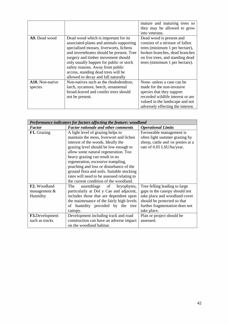
42
mature and maturing trees so they may be allowed to grow into veterans.
A9. Dead wood Dead wood which is important for its associated plants and animals supporting specialised mosses, liverworts, lichens and invertebrates should be present. Tree surgery and timber movement should only usually happen for public or stock safety reasons. Away from public access, standing dead trees will be allowed to decay and fall naturally
Dead wood is present and consists of a mixture of fallen trees (minimum 1 per hectare), broken branches, dead branches on live trees, and standing dead trees (minimum 1 per hectare).
A10. Non-native species
Non-natives such as the rhododendron, larch, sycamore, beech, ornamental broad-leaved and conifer trees should not be present.
None- unless a case can be made for the non-invasive species that they support recorded wildlife interest or are valued in the landscape and not adversely effecting the interest.
Performance indicators for factors affecting the feature: woodland Factor Factor rationale and other comments Operational Limits F1. Grazing A light level of grazing helps to
maintain the moss, liverwort and lichen interest of the woods. Ideally the grazing level should be low enough to allow some natural regeneration. Too heavy grazing can result in no regeneration, excessive trampling, poaching and loss or disturbance of the ground flora and soils. Suitable stocking rates will need to be assessed relating to the current condition of the woodland.
Favourable management is often light summer grazing by sheep, cattle and /or ponies at a rate of 0.05 LSU/ha/year.
F2. Woodland management & Humidity
The assemblage of bryophytes, particularly at Dol y Cae and adjacent, includes those that are dependent upon the maintenance of the fairly high levels of humidity provided by the tree canopy.
Tree felling leading to large gaps in the canopy should not take place and woodland cover should be protected so that further fragmentation does not take place.
F3.Development such as tracks
Development including track and road construction can have an adverse impact on the woodland habitat.
Plan or project should be assessed.
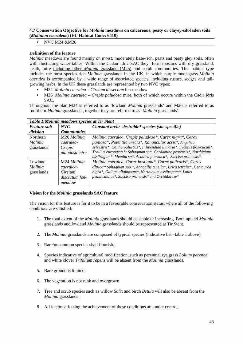
43
4.7 Conservation Objective for Molinia meadows on calcareous, peaty or clayey-silt-laden soils (Molinion caeruleae) (EU Habitat Code: 6410)
• NVC M24 &M26 Definition of the feature Molinia meadows are found mainly on moist, moderately base-rich, peats and peaty gley soils, often with fluctuating water tables. Within the Cadair Idric SAC they form mosaics with dry grassland, heath, mire including other Molinia grassland (M25) and scrub communities. This habitat type includes the most species-rich Molinia grasslands in the UK, in which purple moor-grass Molinia caerulea is accompanied by a wide range of associated species, including rushes, sedges and tall-growing herbs. In the UK these grasslands are represented by two NVC types:
• M24 Molinia caerulea – Cirsium dissectum fen-meadow • M26 Molinia caerulea – Crepis paludosa mire, both of which occure within the Cadir Idris
SAC. Throughout the plan M24 is referred to as ‘lowland Molinia grasslands’ and M26 is referred to as ‘northern Molinia grasslands’, together they are referred to as ‘Molinia grasslands’. Table 1:Molinia meadows species at Tir Stent Feature sub-division
NVC Communities
Constant an/or desirable* species (site specific)
Northern Molinia grasslands
M26 Molinia caerulea-Crepis paludosa mire
Molinia caerulea, Crepis paludosa*, Carex nigra*, Carex panicea*, Potentila erecta*, Ranunculus acris*, Angelica sylvestris*, Caltha palustris*, Filipendula ulmaria*, Lychnis flos-cuculi*, Trollius europaeus*; Sphagnum sp*, Cardamine pratensis*, Narthicium ossifragum*, Mentha sp*, Achillea ptarmica*, Succisa pratensis*.
Lowland Molinia grasslands
M24 Molinia caerulea-Cirsium dissectum fen-meadow
Molinia caerulea, Carex hostiana*, Carex pulicaris*, Carex dioica* Sphagnum spp.*, Anagallis tenella*, Erica tetralix*, Centaurea nigra*, Galium uliginosum*, Narthicium ossifragum*, Lotus pedunculatus*, Succisa pratensis* and Orchidaceae*
Vision for the Molinia grasslands SAC feature The vision for this feature is for it to be in a favourable conservation status, where all of the following conditions are satisfied:
1. The total extent of the Molinia grasslands should be stable or increasing. Both upland Molinia grasslands and lowland Molinia grasslands should be represented at Tir Stent.
2. The Molinia grasslands are composed of typical species (indicative list –table 1 above).
3. Rare/uncommon species shall flourish.
4. Species indicative of agricultural modification, such as perennial rye grass Lolium perenne
and white clover Trifolium repens will be absent from the Molinia grasslands.
5. Bare ground is limited.
6. The vegetation is not rank and overgrown.
7. Tree and scrub species such as willow Salix and birch Betula will also be absent from the Molinia grasslands.
8. All factors affecting the achievement of these conditions are under control.
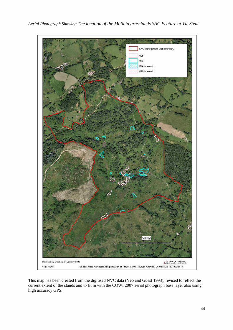
44
Aerial Photograph Showing The location of the Molinia grasslands SAC Feature at Tir Stent
This map has been created from the digitised NVC data (Yeo and Guest 1993), revised to reflect the current extent of the stands and to fit in with the COWI 2007 aerial photograph base layer also using high accuracy GPS.

45
Performance indicators for Molinia grasslands The performance indicators are part of the conservation objective, not a substitute for it. Assessment of plans and projects must be based on the entire conservation objective, not just the performance indicators. Performance indicators for feature condition: Molinia grasslands Attribute Attribute rationale and other
comments Specified limits
A1. Extent Lower limit is based on current extent of the lowland Molinia grasslands and upland Molinia grasslands. Taken from the revised NVC map shown above. The extent figures have been rounded down to account for the stands of Molinia grasslands found in mosaic.
Within Tir Stent (Unit 9) Upper limit: None set. Molinia grasslands SAC feature: Lower limit: 1.5 ha Of which there will be 0.9 ha of lowland Molinia meadows and 0.6 ha of upland Molinia meadows. Map above shows the current extent of the Molinia meadows SAC feature.
A2. Typical species
These targets are based on the Standard CSM attributes for this feature. Modified according to site specific requirements.
(i)The grassland is species rich with at least two positive indicator species present throughout the sward. (ii)There is a high density of Succisa pratensis plants. An additional lower limit has been set for the presence of Succisa pratensis as this is the host plant for the marsh fritillary butterfly – a key SAC species on this site.
A3 Rare species
Map Rarities/ Notable species of the Molinia meadows feature should be maintained: Dactylorhisa incanata, D.majalis ssp. purpurella, Gymnadenia conoposa, and Planthera bifolia, P. chlorantha, Coeloglossum viride, Ophioglossum vulgatum, Dryopteris carthusiana, Trollius europeus, Hamatocaulis vernicosus.
A4 Undesirable species & cover
Some species are indicative of degradation and loss of valued botanical biodiversity. Juncus acutiflorus cover-Rodwell (1991) for M24 is II (1-7) less than 50% and M26 is IV (1-5) less than 25%. Molinia for M24 and M26 is V (1-8) up to 80% cover.
(i)The desirable rush species (not J.effusus) and Molinia should be of an expected frequency and cover. (ii)The cover of rank grasses such as Deschampsia cespitosa is low. (iii)The combined cover of other grasses (Holcus lanatus, Nardus stricta and Agrostis sp.) is low. (iv)Arrhenatherum elatius, Trifolium repens & Ranunculus repens should be absent or rare.
A5. Bare ground
Bare ground is indicative often of trampling, erosion and over grazing. This is of concern if bare ground is frequent and/or extensive.
Bare ground is no more that 10% of the sward and no areas of bare ground should be present which are greater than 1m x 1m within the Molinia SAC feature.
A6. Vegetation height
The botanical diversity and suitability for marsh fritillary is greatest when the vegetation is not rank and overgrown (between 10 and 25 cms).
The grass height of the SAC feature should be below 45cms with at least 50% less than 30cms and of that at least 50% should be less than 20cm. This guidance would need to be field tested. Grass height close to and including Succisa is particularly important ie it should not be rank.
A7 Trees, scrub & bracken.
Notes should be taken of any tree or scrub species present of a lesser height so that management action can be taken before the stand ‘fails’.
Tree, or scrub species, over 30cm in height, bramble and bracken, are all absent.

46
Performance indicators for factors affecting the Molinia grasslands Factor Factor rationale and other comments Operational Limits F1. Grazing Without an appropriate grazing regime,
the grassland would become rank and over dominated by Molinia or rushes to such an extent that other species are shaded out and a thick litter layer develops also suppressing the growth of smaller herbs. Too low grazing levels can also lead to scrub invasion and total loss of the Molinia grasslands, to scrub and woodland in the long term. Light grazing preferably by cattle or ponies between April and November each year is essential in maintaining the marshy grassland communities.
At Tir Stent (Unit 9): 0.3 lsu/ha/yr is a guide.
• Light summer grazing by cattle or ponies is essential.
• Light winter grazing by sheep is acceptable.
F2. Hydrological regime
Base rich flushing creates the conditions which suit the calcicolous species that characterise the Molinia meadows. It is essential that the hydrological regime is not altered by ditching or water abstraction.
Within Tir Stent (Unit 9):
• There should be no artificial drainage or water abstraction on the site which would alter the hydrological regime of the Molinia grasslands.
F3. Access Pressure from people, livestock and vehicles including bicycles can be of concern. The delicate habitat mosaic at Tir Stent with it’s complex system of flushes is easily damaged by trampling and the creation of tracks which cause loss or damage to vegetation, compaction and could even alter the system of flushing at the common.
Within Tir Stent (Unit 9):
• Trampled, heavily poached areas or tracks created by vehicle, or visitor damage should be absent or rare at vulnerable locations.
F4. Scrub encroachment
Within Tir Stent (Unit 9) the Molinia grass lands exist within a mosaic of woodland, bracken, heath, flush and scrub. They are therefore, particularly vulnerable to scrub encroachment. The upper limit is based on the current extent of the woodland, scrub and bracken.
Within Tir Stent (Unit 9):
• Upper limit: 65% of Tir Stent is made up of Bracken trees or scrub.
• Lower limit: 40% of Tir Stent is Bracken, trees or scrub.

47
4.8 Conservation Objective for: Alkaline Fens (EU Habitat Code: 7230)
• NVC M10 Definition of the feature The alkaline fens vegetation on Cadair is primarily associated with base rich flushes supporting specialist species characteristic of water logged alkaline conditions. The vegetation is generally short, dominated by bryophtyes, short sedges or dicotyledons with brown mosses a constant element of the community. Alkaline fens on Cadir fall into the following NVC type M10 Carex dioica – Pinguicula vulgaris mire. Alkaline fen Typical Species-constants and/or desirable* NVC M10 Carex dioica- Pinguicula vulgaris mire
Carex dioica*, Carex hostiana*, Carex viridula*, Carex panicea*, Carex pulicaris*, Eriophorum angustifolium, Juncus articulatus, Pinguicula vulgari*s, Succisa pratensis, Selaginella selaginoides*, Menyanthes trifoliate*, Linum cathaticum*, Pedicularis paludosa*, Juncus bulbosa, Erica tetralix, Narthecium ossifragum and Eleocharis quinqueflora, Drepanocladus revolvens*, Cratenuron commutatum*, Scorpidium scorpioides*, Campylium stellatum*. Dryer stands support, Blindia acuta, Britzia media, Carex flacca.
Vision for Alkaline Fens The vision for the feature is for it to be in a favourable conservation status, where all of the following conditions are satisfied:
1. The total extent of the alkaline fen vegetation should be stable or increasing. 2. The alkaline fens are vegetated primarily with the desirable species listed in the table 3. The alkaline fens have a low frequency/cover of Molinia caerulea and rushes. 4. Tree and scrub species such as willow Salix and birch Betula are absent. 5. All factors affecting the achievement of these conditions are under control.
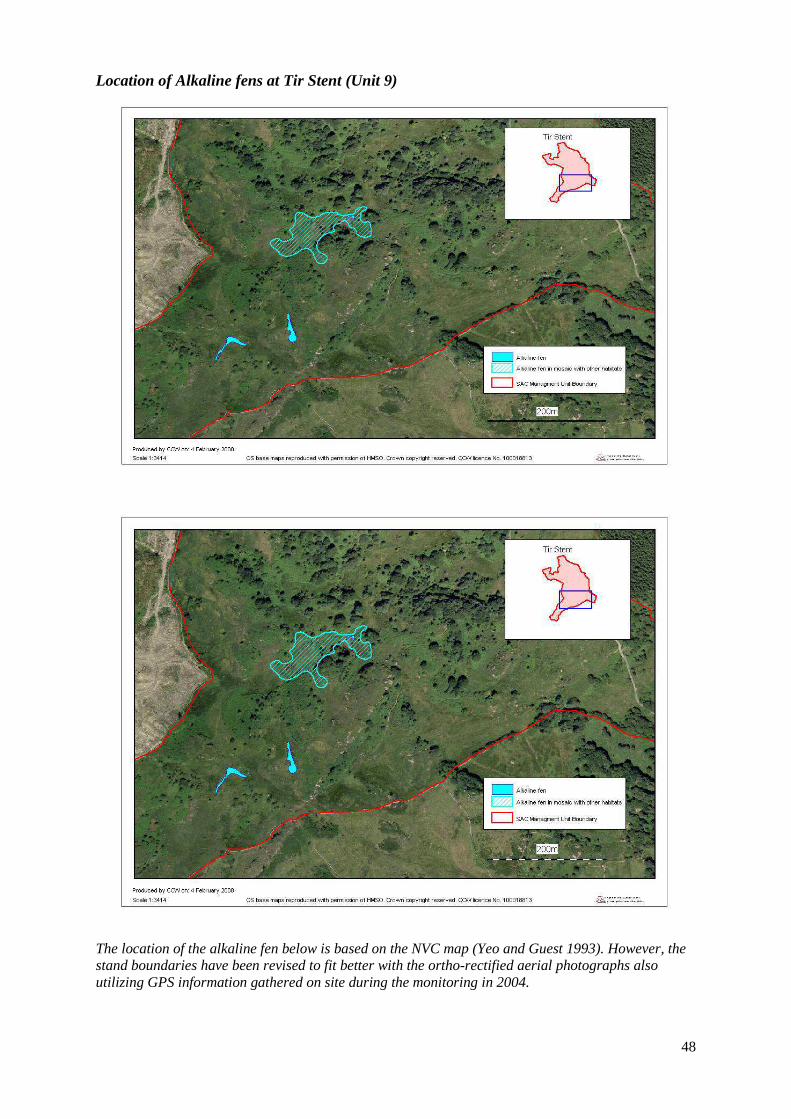
48
Location of Alkaline fens at Tir Stent (Unit 9)
The location of the alkaline fen below is based on the NVC map (Yeo and Guest 1993). However, the stand boundaries have been revised to fit better with the ortho-rectified aerial photographs also utilizing GPS information gathered on site during the monitoring in 2004.
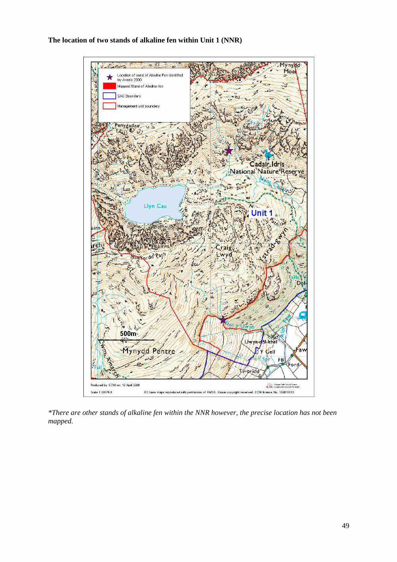
49
The location of two stands of alkaline fen within Unit 1 (NNR)
*There are other stands of alkaline fen within the NNR however, the precise location has not been mapped.

50
Performance indicators for Feature: Alkaline Fen The performance indicators are part of the conservation objective, not a substitute for it. Assessment of plans and projects must be based on the entire conservation objective, not just the performance indicators. Performance indicators for feature condition: Alkaline Fens Attribute, rationale and other comments Specified limits A1. Extent & location of the Alkaline Fen At Tir Stent the target for extent is taken from the revised NVC Map (Yeo and Guest 2004) shown above. The targets for Unit 1 (NNR) are taken from the NVC survey of the NNR (Averis & Averis 2000). It states that there are ‘one or two stands [of M10] on the south facing slopes of Mynydd Moel in flushed stream gullies on steep crumbling slopes, and others on the southern slopes of Ystrad Gwyn in mosaics with other types of soligenous mire.’ These are difficult to pick out on the NVC map, however, two quadrat samples were taken at: Easting 722, Northing 128, and Easting 721, Northing 113. See Figure 2. It is likely that there are other stands of Alkaline fen within the SAC which have yet to be mapped.
Limits: As yet the full extent of alkaline fens within the SAC is not known since the whole of Cadair Idris has not undergone vegetation mapping to such a fine level as to pick out all stands of NVC M10. (i)The current extent of the Alkaline Fen should be maintained. (ii)Within Tir Stent (Unit 9) There should be at least 0.7 ha of Alkaline Fen
A2. Typical species of Alkaline Fen These targets are based on targets outlined by the Common Standards Monitoring Guidance for Alkaline Fens (Uplands). However, they have been adapted to reflect the species composition at Tir Stent. The targets for quality only relate to Tir Stent as this is by far the most important location for alkaline fens on site. These are typical and desirable species.
Within Tir Stent (Unit 9): (i) The alkaline fen is vegetated primarily with the desirable species listed - dominated by one or more of the following; brown mosses, small sedges, Eriophorum spp. or Menyanythes trifoliata. (ii)At least 10% of the vegetation is always made up of brown mosses such as such as Scorpidium scorpioides, Cratoneuron commutatum and Drepanocladus revolvens) and base demanding sedges such as Carex dioica, Carex pulicaris, Carex hositana or Carex viridula are frequent throughout the sward. (iii)Less than 25% of the vegetation should consist of either Juncus sp. or Molinia,
A3 Molinia/rush/Bracken (i) Juncus such as J. squarrosus and J.acutiflorus should have a frequency of I or zero. Molinia should have a cover of less than 25% and normally be towards the margins of this localised community. Bracken should be absent.
A4 Trees, scrub& bracken. Notes should be taken of any tree or scrub species present of a lesser height so that management action can be taken before the stand fails
(i) There should be no trees shrub species (excluding seedlings <20cm in height). (ii) There should be <25% disturbed bare ground.
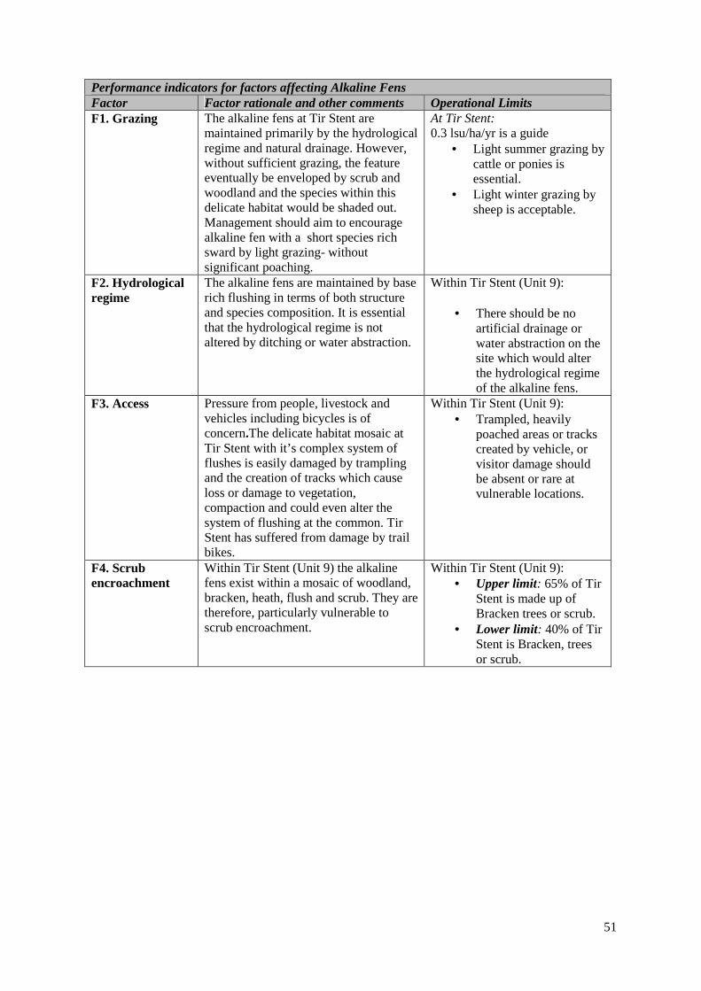
51
Performance indicators for factors affecting Alkaline Fens Factor Factor rationale and other comments Operational Limits F1. Grazing The alkaline fens at Tir Stent are
maintained primarily by the hydrological regime and natural drainage. However, without sufficient grazing, the feature eventually be enveloped by scrub and woodland and the species within this delicate habitat would be shaded out. Management should aim to encourage alkaline fen with a short species rich sward by light grazing- without significant poaching.
At Tir Stent: 0.3 lsu/ha/yr is a guide
• Light summer grazing by cattle or ponies is essential.
• Light winter grazing by sheep is acceptable.
F2. Hydrological regime
The alkaline fens are maintained by base rich flushing in terms of both structure and species composition. It is essential that the hydrological regime is not altered by ditching or water abstraction.
Within Tir Stent (Unit 9):
• There should be no artificial drainage or water abstraction on the site which would alter the hydrological regime of the alkaline fens.
F3. Access Pressure from people, livestock and vehicles including bicycles is of concern.The delicate habitat mosaic at Tir Stent with it’s complex system of flushes is easily damaged by trampling and the creation of tracks which cause loss or damage to vegetation, compaction and could even alter the system of flushing at the common. Tir Stent has suffered from damage by trail bikes.
Within Tir Stent (Unit 9): • Trampled, heavily
poached areas or tracks created by vehicle, or visitor damage should be absent or rare at vulnerable locations.
F4. Scrub encroachment
Within Tir Stent (Unit 9) the alkaline fens exist within a mosaic of woodland, bracken, heath, flush and scrub. They are therefore, particularly vulnerable to scrub encroachment.
Within Tir Stent (Unit 9): • Upper limit: 65% of Tir
Stent is made up of Bracken trees or scrub.
• Lower limit: 40% of Tir Stent is Bracken, trees or scrub.

52
4.9 Conservation Objective for Feature 12: Slender green feather moss. Drepanocladus (Hamatocaulis) vernicosus (EU Species Code: 1393) Definition of the feature Slender green feather-moss is a medium-sized straggling moss. Within the Cadair SAC it is found in base-rich flushes and springs, in association with other characteristic mosses of base-rich flushes and fens, such as Campylium stellatum and Scorpidium scorpioides, and liverworts such as Leiocolea bantriensis. Drepanocladus and related genera are taxonomically difficult and the group has recently been revised. Drepanocladus vernicosus is referred to in most current literature and throughout this management plan as Hamatocaulis vernicosus. The known Hamatocaulis colonies at Tir Stent exist primarily within neutral fen but it is also found in rush pastures (NVC M23), alkaline fens(NVC M10) and marshy grassland(NVC M24, M25 &M26). However, Hamatocaulis is not restricted to these NVC communities. The neutral fen or flush at Tir Stent is 'floristically intermediate between M6 and M10. It has a sphagnum lawn made up of base tolerant species. e.g Sphagnum contortum, S. teres and S. warnstorfii. 'Other bryophytes are rarely predominant but small amounts of Aneura, Drepanocladus revolvens and Campylium stellatum are characteristic of the community. Most of these flushes are dominated by grasses and short sedges including basiphilous species such as Carex dioica, C. pulicaris, C. hostiana. Other species include Pinguicula, Erica tetralix, Drosera rotundifolia, Narthicuim and Menyanthes. Slender green feather-moss essentially favours damp, base rich habitats with high light levels. Vision for Hamatocaulis vernicosus The vision for this feature is for it to be in a favourable conservation status, where all of the following conditions are satisfied:
1. The population of Hamatocaulis vernicosus is stable or increasing. 2. The habitats, which support the Hamatocaulis vernicosus, should be in good condition.
3. All factors affecting the achievement of these conditions are under control.
Performance indicators for Hamatocaulis vernicosus The performance indicators are part of the conservation objective, not a substitute for it. Assessment of plans and projects must be based on the entire conservation objective, not just the performance indicators.
Performance indicators for feature condition: Hamatocaulis vernicosus Attribute Attribute rationale and other
comments Specified limits
A1. Population of Hamatocaulis vernicosus
The population of Hamatocaulis was surveyed at Tir Stent (Unit 9) in 2004 (Bosanquet 2004). A map showing the locations of the known colonies of Hamatocaulis vernicosus at Tir Stent is shown in figure y below). Tir Stent is the most likely place on site to support Hamatocaulis because of the base rich flushing which creates favourable conditions for the species.
The whole of Cadair Idris SAC has not been surveyed and where the habitat conditions are right other populations of Hamatocaulis could exist outside of Tir Stent. Within Tir Stent (Unit 9): (i)There should be at least 8 colonies of 100 or more Hamatocaulis stems present within a stand of good quality flush vegetation (at least 1m x 1m in area) within 5 different flushes (Flushes A-K highlighted on figure x below)) at Tir Stent. (ii)There should be least 2 colonies of over 1000 H.vernicosus stems present in good quality flush vegetation (at least 2m x 2m in area) within two different flushes (Flushes

53
A-K highlighted on the map below) within Tir Stent.
A2. Condition of the habitat supporting the Hamatocaulis vernicosus
H.vernicosus favoured areas where the vegetation was open with a rush cover of <20%. Although the species was found in areas of more dense rush cover- up to 80%, H.vernicosus in this situation was more scattered and less robust.
Within Tir Stent (Unit 9): The Hamatocaulis colonies should be supported by at least 1m x 1m of good quality habitat where: (i)Rush cover should be 20% or less (ii)There should be <10% disturbed bare ground
(iii)Bracken, and tree and scrub species >30cm in height should be absent
Performance indicators for factors affecting the feature: Hamatocaulis vernicosus Factor Factor rationale and other
comments Operational Limits
F1. Grazing Light grazing is essential for the maintenance of open flush and grassland communities and to help prevent scrub encroachment. Grazing should keep levels of rushes,grasses such as Molinia down and scrub, maintaining the high light levels which Hamatocaulis vernicosus requires. Excessive poaching on the other hand could cause damage or total loss H.vernicosus colonies.
At Tir Stent (Unit 9): 0.3 lsu/ha/yr is a guide (i)Light summer grazing by cattle or ponies is essential. (ii)Light winter grazing by sheep is acceptable.
F2. Hydrological regime/ water chemistry
H.vernicosus is dependant on a high water table and a specific pH range.
Within Tir Stent (Unit 9): (i) There should be no artificial drainage or water abstraction on the site which would alter the hydrological regime.
F3. Pressure from people, livestock and vehicles including bicycles.
Trampling and the creation of tracks could cause loss or damage to H. vernicosus colonies or could even alter the system of flushing at the common which creates the right conditions for H. vernicosus to grow.
Within Tir Stent (Unit 9): (i)Trampled, heavily poached areas or tracks created by vehicle, or visitor damage should be absent or rare at vulnerable locations.
F4. Scrub Within Tir Stent (Unit 9) the open, damp habitats which support Hamatocaulis vernicosus exist within a mosaic of woodland, bracken, heath, flush and scrub. They are therefore, particularly vulnerable to scrub encroachment.
Within Tir Stent (Unit 9): Upper limit: 65% of Tir Stent is made up of Bracken trees or scrub. Lower limit: 40% of Tir Stent is Bracken, trees or scrub.

54
Locations of known colonies of Hamatocaulis vernicosus within Tir Stent (Unit 9)
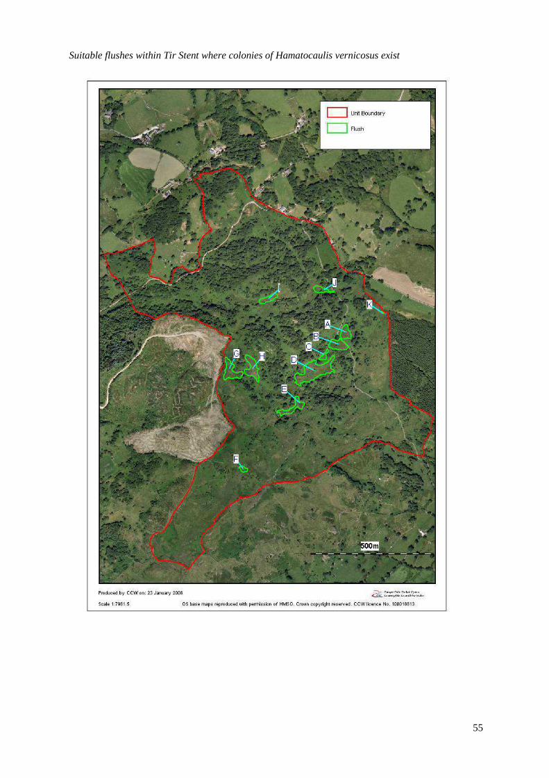
55
Suitable flushes within Tir Stent where colonies of Hamatocaulis vernicosus exist
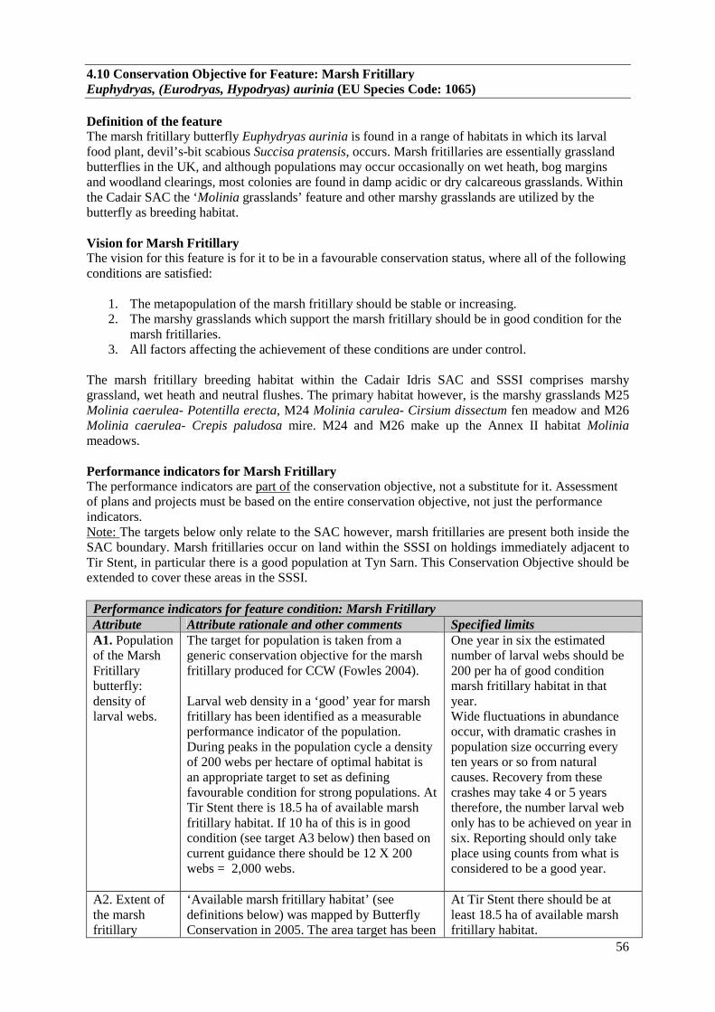
56
4.10 Conservation Objective for Feature: Marsh Fritillary Euphydryas, (Eurodryas, Hypodryas) aurinia (EU Species Code: 1065) Definition of the feature The marsh fritillary butterfly Euphydryas aurinia is found in a range of habitats in which its larval food plant, devil’s-bit scabious Succisa pratensis, occurs. Marsh fritillaries are essentially grassland butterflies in the UK, and although populations may occur occasionally on wet heath, bog margins and woodland clearings, most colonies are found in damp acidic or dry calcareous grasslands. Within the Cadair SAC the ‘Molinia grasslands’ feature and other marshy grasslands are utilized by the butterfly as breeding habitat. Vision for Marsh Fritillary The vision for this feature is for it to be in a favourable conservation status, where all of the following conditions are satisfied:
1. The metapopulation of the marsh fritillary should be stable or increasing. 2. The marshy grasslands which support the marsh fritillary should be in good condition for the
marsh fritillaries. 3. All factors affecting the achievement of these conditions are under control.
The marsh fritillary breeding habitat within the Cadair Idris SAC and SSSI comprises marshy grassland, wet heath and neutral flushes. The primary habitat however, is the marshy grasslands M25 Molinia caerulea- Potentilla erecta, M24 Molinia carulea- Cirsium dissectum fen meadow and M26 Molinia caerulea- Crepis paludosa mire. M24 and M26 make up the Annex II habitat Molinia meadows. Performance indicators for Marsh Fritillary The performance indicators are part of the conservation objective, not a substitute for it. Assessment of plans and projects must be based on the entire conservation objective, not just the performance indicators. Note: The targets below only relate to the SAC however, marsh fritillaries are present both inside the SAC boundary. Marsh fritillaries occur on land within the SSSI on holdings immediately adjacent to Tir Stent, in particular there is a good population at Tyn Sarn. This Conservation Objective should be extended to cover these areas in the SSSI. Performance indicators for feature condition: Marsh Fritillary Attribute Attribute rationale and other comments Specified limits A1. Population of the Marsh Fritillary butterfly: density of larval webs.
The target for population is taken from a generic conservation objective for the marsh fritillary produced for CCW (Fowles 2004). Larval web density in a ‘good’ year for marsh fritillary has been identified as a measurable performance indicator of the population. During peaks in the population cycle a density of 200 webs per hectare of optimal habitat is an appropriate target to set as defining favourable condition for strong populations. At Tir Stent there is 18.5 ha of available marsh fritillary habitat. If 10 ha of this is in good condition (see target A3 below) then based on current guidance there should be 12 X 200 webs = 2,000 webs.
One year in six the estimated number of larval webs should be 200 per ha of good condition marsh fritillary habitat in that year. Wide fluctuations in abundance occur, with dramatic crashes in population size occurring every ten years or so from natural causes. Recovery from these crashes may take 4 or 5 years therefore, the number larval web only has to be achieved on year in six. Reporting should only take place using counts from what is considered to be a good year.
A2. Extent of the marsh fritillary
‘Available marsh fritillary habitat’ (see definitions below) was mapped by Butterfly Conservation in 2005. The area target has been
At Tir Stent there should be at least 18.5 ha of available marsh fritillary habitat.
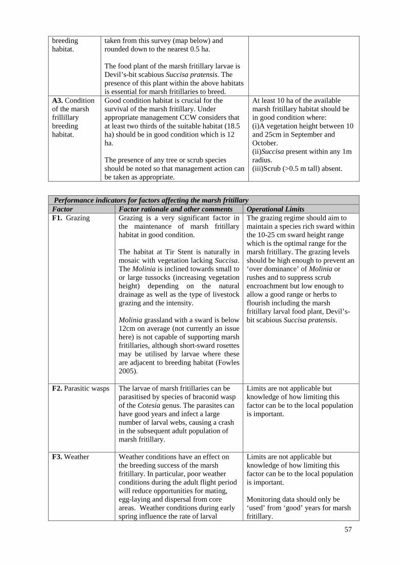
57
breeding habitat.
taken from this survey (map below) and rounded down to the nearest 0.5 ha. The food plant of the marsh fritillary larvae is Devil’s-bit scabious Succisa pratensis. The presence of this plant within the above habitats is essential for marsh fritillaries to breed.
A3. Condition of the marsh frillillary breeding habitat.
Good condition habitat is crucial for the survival of the marsh fritillary. Under appropriate management CCW considers that at least two thirds of the suitable habitat (18.5 ha) should be in good condition which is 12 ha. The presence of any tree or scrub species should be noted so that management action can be taken as appropriate.
At least 10 ha of the available marsh fritillary habitat should be in good condition where: (i)A vegetation height between 10 and 25cm in September and October. (ii)Succisa present within any 1m radius. (iii)Scrub (>0.5 m tall) absent.
Performance indicators for factors affecting the marsh fritillary Factor Factor rationale and other comments Operational Limits F1. Grazing Grazing is a very significant factor in
the maintenance of marsh fritillary habitat in good condition. The habitat at Tir Stent is naturally in mosaic with vegetation lacking Succisa. The Molinia is inclined towards small to or large tussocks (increasing vegetation height) depending on the natural drainage as well as the type of livestock grazing and the intensity. Molinia grassland with a sward is below 12cm on average (not currently an issue here) is not capable of supporting marsh fritillaries, although short-sward rosettes may be utilised by larvae where these are adjacent to breeding habitat (Fowles 2005).
The grazing regime should aim to maintain a species rich sward within the 10-25 cm sward height range which is the optimal range for the marsh fritillary. The grazing levels should be high enough to prevent an ‘over dominance’ of Molinia or rushes and to suppress scrub encroachment but low enough to allow a good range or herbs to flourish including the marsh fritillary larval food plant, Devil’s-bit scabious Succisa pratensis.
F2. Parasitic wasps The larvae of marsh fritillaries can be parasitised by species of braconid wasp of the Cotesia genus. The parasites can have good years and infect a large number of larval webs, causing a crash in the subsequent adult population of marsh fritillary.
Limits are not applicable but knowledge of how limiting this factor can be to the local population is important.
F3. Weather Weather conditions have an effect on the breeding success of the marsh fritillary. In particular, poor weather conditions during the adult flight period will reduce opportunities for mating, egg-laying and dispersal from core areas. Weather conditions during early spring influence the rate of larval
Limits are not applicable but knowledge of how limiting this factor can be to the local population is important. Monitoring data should only be ‘used’ from ‘good’ years for marsh fritillary.

58
development of the marsh fritillary and the effects of the parasitic wasp (see above).
F4.Survival of Metapopulations and the condition of their supporting habitat outside of the SAC.
The bulk of the population at Cadair is centred on Tir Stent (Unit 9) and Tyn Sarn with low numbers of webs recorded within adjacent units or just over the SSSI/SAC boundaries. However, there are a couple of more distant clusters of marsh fritillary web records within 2 km of the main concentrations.
Lower Limit: Metapopulations should not be lost as a result of anthropogenic factors such as changes to habitat management or habitat loss due to development. A lower limit has been set here but control over habitat management or development etc outside of the SAC/SSSI is itself limited.
59
The distribution of Marsh Fritillary Breeding habitat within Tir Stent (Unit 9) and adjacent land within the SSSI Tyn Sarn. Mapped by Butterfly Conservation in 2005 according to the Generic Habitat Attributes listed below (Fowles 2005)
60
Generic Habitat Attributes Suitable (Under-grazed) Habitat (SU): Molinia grassland where Succisa pratensis is occasional/frequent/abundant and vegetation height is above 25cms, or in which sward height is between 12-25 cms but scrub ([>0.5] metres tall) covers no more than 10% of area. Such habitat is capable of supporting marsh fritillaries in its current condition but its significance will decline over a 5-10 year period unless action is taken. Restoration of appropriate grazing levels (perhaps requiring initial management in the form of mowing or patch burning before the introduction of stock) should improve habitat quality to Good Condition. Suitable (Over-grazed) Habitat (SO): Molinia grassland with frequent-abundant Succisa but which is currently over-grazed such that the sward is below 12cm on average. Such habitat is not capable of supporting marsh fritillaries in its current condition, although short-sward rosettes may be utilised by larvae where these are adjacent to breeding habitat. Reductions in stocking density to approximately 0.3-0.4 livestock units should improve vegetation structure towards Good Condition in the short term. Suitable (Sparse) Habitat (SS): Molinia grassland with sparse Succisa and vegetation height less than 25 cms on average. Superficially these patches may have good vegetation structure but the paucity of Succisa means that they are less favoured by marsh fritillaries. Edaphic conditions may dictate the abundance of Succisa but this may also be due to past or current management practices, such as frequent mowing in the absence of grazing animals. If this is the case then re-introduction of grazing stock may break up the sward sufficiently to allow germination of any Succisa within the seed bank and Good Condition habitat may return in the near future. Traditionally grazed SS habitat may simply lack the correct soil conditions for frequent Succisa and hence these patches may never attain Good Condition without costly intervention. Overspill Grassland (OG): Grassland in which Molinia is sparse or absent and which contains frequent/abundant Succisa. Further observations are required on the value of such grasslands to marsh fritillaries but it is currently believed that they offer breeding habitat as overspill from occupied Molinia pasture in favourable situations. Such grasslands may require alterations to the stocking density in order to achieve or maintain appropriate vegetation structure, though further research is necessary to define optimal sward heights. Potential (Rank) Habitat (PR): Molinia grassland with rare Succisa but which is currently under-grazed or neglected such that the sward is above 25cm on average and Succisa occurs as scattered plants in a rank, tussocky sward. Management of such grasslands will require considerable effort (in the form of mowing, patch burning and probably scrub control) before grazing can be introduced at appropriate levels. Where landscapes are regarded as containing insufficient habitat to guarantee long-term viability of the marsh fritillary metapopulation, Potential (Rank) patches will offer the best option for habitat restoration but they are unlikely to support anything more than the occasional larval web without management. Unsuitable Habitat (NS): All other habitat types are mapped under this category. This will include patch types that potentially could be restored to support marsh fritillaries but this is likely to involve a considerable resource input to correct former agricultural practices or to alter soil hydrology. Swards in which both Molinia and Succisa are rare, regardless of vegetation height, would classify here, as would swards in which Succisa is no more than occasional amongst non-Molinia grassland. These were the habitat mapping definitions used for the mapping and for terms used in the in the performance indicator. Available Marsh Fritillary Habitat is taken as the sum of the Good Condition Habitat, the Suitable Habitat and the Potential Habitat.

61
5. ASSESSMENT OF CONSERVATION STATUS AND MANAGEMENT REQUIREMENTS This part of the document provides: • A summary of the assessment of the conservation status of each feature. • A summary of the management issues that need to be addressed to maintain or restore each feature. The management requirements of the Molinia grasslands, alkaline fens and Hamatocaulis vernicosus are similar and are therefore dealt with together in section 5.
5.1 Conservation Status and Management Requirements of Clear-water lakes Conservation Status of the clear-water lakes Feature Condition: The clear-water lakes feature is currently considered to be Favourable: Unclassified Status: The clear-water lakes feature is currently considered to be Favourable Reference: 'Site condition assessments of Welsh SAC and SSSI standing water features Reports Name(s) Burgess, A. ,Goldsmith, B., Hatton-Ellis, T. Series CCW Science Report (705) Publication Bangor : Countryside Council for Wales (CCW), 2006' Management Requirements of lake features • Grazing-stocking levels on Cadair Idris should be monitored and controlled to ensure that
sediment and nutrient loadings to the lakes do not increase as a result of overgrazing. • It is recommended that all lakes surveyed within this SAC continue to be monitored. If funds are limited, then it is recommended that Llyn Arran and Llyn Cau receive greatest attention since both sites are sensitive to acid deposition and may be useful sites to monitor with respect to post-acidification recovery trends in both biological and chemical elements. WFD risk assessments have not been completed for Llyn Gafr and Llyn Arran because they are too small to be considered as ‘water bodies’ under the WFD. However, limited disturbance within the catchments of these lakes suggests a low risk of impact. Llyn Cau has been classified as being at risk from diffuse pollution, further supporting the recommendation that this site should be included in future monitoring programmes. The sources of diffuse pollution should be determined and monitored accordingly in order to protect the lake from deterioration to unfavourable condition. 5.2 Conservation Status and Management Requirements of Siliceous scree Condition: The siliceous scree is currently graded as Favourable: maintained. Reference: SAC monitoring carried out in 2005 by Heather Lewis. Status: Favourable Reference: Regional assessment of factors. Management Requirements for siliceous scree Direct management of this feature is minimal since this feature is governed primarily by natural factors such as disturbance and soil depth rather than by management
62
Grazing The vegetation of the screes is maintained by physical factors such as disturbance form the mobile scree and soil depth rather than by grazing. However, some of the scree slopes below the level of the natural tree line have the potential to be covered by heath, scrub or trees if grazing on the adjacent habitats is very low or absent. Grazing can also keep the screes mobile, livestock moving across the scree can maintain disturbed conditions which favour the scree vegetation, preventing the establishment of tree and scrub species which are intolerant of disturbance. High grazing levels can lead to too much destabilisation of the scree by livestock. High grazing can also lead to the damage and loss of the scree vegetation by species being grazed out or repressed. Some paths created by livestock were noted within Units 1 and 5 however, these are currently not thought to be detrimental to the vegetation. 1. Units 1 and 5 should continue to be lightly grazed. Access Scrambling, walking and scree running are becoming more popular. Although mobile screes are desirable, too much disturbance can lead to total loss of all vegetation with even the development of lichen dominated communities being prevented. Damage to the screes within Units 1 and 5 by human pressure is not currently an issue however, elsewhere on site, for example on ‘Foxes Path’ the scree slopes are suffering from increased mobility. 2. Access management should aim to minimise the impact of people pressure on the screes and to
monitor any further damage to screes in particular those within Units 1 and 5. 3. There should be no new paths or scree ‘runs’ established. 5.3 Conservation Status and Management Requirements of SAC features:
• Calcareous rocky slopes • Siliceous rocky slopes with chasmophytic • Hydrophilous tall herb fringe communities
Conservation Status of the tall herb ledges & chasmophytic vegetation features Condition:The tall herbledges&chasmophytic vegetation is currently graded as Favourable: maintained Reference: SAC monitoring carried out in 2005 by Heather Lewis. Status: Favourable Reference: Regional assessment of factors. Monitoring was only carried out at Llyn Y Gafr (Unit 14) and Cwn Cau (NNR, Unit 1), Llyn Arran was not visited. Very few areas of siliceous chasmophytic vegetation were identified during the monitoring because the outcrops visited were primarily calcareous rocks. However, the siliceous chasmophytic vegetation is well dispersed over the cliffs and crags on Cadair outside of the areas where monitoring took place. It is mostly inaccessible and would be near impossible to map. Since the factors affecting the chasmophytic vegetation are few, we can assume that the chasmophytic vegetation is favourable where it exists in inaccessible areas. Therefore, the performance indicator focuses on the accessible cliffs and crags at Cwm Cau and above Llyn Y Gafr. Future monitoring should also take in the Llyn Y Gafr Crags. Although the rock in these two areas is known to have a calcareous nature in parts, the calcareous influence this is often patchy and acid vegetation of interest often occurs in mosaic on the crags. Tall herb ledges and outcrops supporting chasmophytic vegetation which were easily accessible or visible from safe ground were identified, mapped onto oblique photographs where possible and

63
visually assessed against the targets outlined in the performance indicator. The areas which could potentially support tall herb vegetation at the base of the cliffs was not included within the assessment because the monitoring focused on the current extent of the tall herb vegetation. Out of the 11 outcrops assessed at Llyn y Gafr (Unit 14) and the 10 outcrops assessed at Cwm Cau (Unit 1) all were considered to be in good condition. See above, this makes Cadair probably the only site where these are favourable. We need some consistency in monitoring this habitat Management Requirements for tall herb ledges and chasmophytic vegetation Direct management of this feature is minimal since this feature is governed by natural factors such as soil depth and acidity and hydrology rather than by management Grazing The majority of the tall herb ledges and chasmophytic vegetation is out of reach from grazing livestock. However, the lowest ledges and some areas to the base of cliffs could potentially support tall herb vegetation if grazing was removed or very low. Grazing can damage or lead to the total loss of this habitat by preventing flowering, causing a decline in species diversity and an increase in grasses tolerant of grazing such as Nardus stricta, Agrostis capillaris and Anthoxanthum odoratum. Grazing currently appears not to be significantly affecting the lower ledges but is preventing the vegetation surrounding the outcrops from developing into tall herb vegetation where the soils would allow. A relaxation in the grazing levels would clearly be beneficial to the tall herb and chasmophytic vegetation Some of the lower and smaller outcrops below the level of the natural tree line have the potential to be covered up by trees in the absence of grazing. However, this is not currently a threat. 1. Grazing levels within units 1, 13 and 14 need to be reviewed. Management should aim to keep the grazing levels on adjacent habitats as low as possible. Access Scrambling and climbing are becoming more popular. Although there are no current known impacts from climbing, this is a potential risk. Climbing can lead to the loss or damage to vegetation from trampling on ledges or the removal of vegetation from crevices. However, most summer climbing tends to take place on the more massive, siliceous rocks, so pressure on these habitats remains low. Winter climbing in minimal snow/ice conditions can pose a threat and should be monitored.
• The levels of climbing and related activities within the sensitive areas at Llyn Y Gafr (Unit 14), Cwm Cau (Unit 1) and Llyn Arran (Unit 13 and 14) should be monitored. If climbing increases in these areas and impinges on the tall herb ledges and chasmophytic vegetation then agreements should be drawn up with the British Mountaineering Council to restrict climbing to non sensitive parts of the site.
64
5.4 Conservation Status and Management Requirements of European dry heaths and Northern Atlantic wet heath Conservation Status of the European dry heath Condition: The dry heath is assessed as Unfavourable: Declining. Reference: Reference: Gray, D.,D. (2004) A habitat condition assessment of the ‘European dry heath’, Northern Atlantic Wet Heath with Erica tetralix’ and ‘blanket bog’ at the Cadair Idris candidate Special Area of Conservation. Central Environmental Surveys. CCW Environmental Monitoring Report no.11. Status: Unfavourable Reference: Regional assessment of factors not being under control. The dry heath, wet heath and blanket bog were condition mapped and monitoring plots were placed in parts of the site where these habitats considered to be a key habitat. For the condition mapping, stands of dry heath of uniform condition were mapped and assessed against attributes based on those suggested by the Uplands Common Standards Monitoring but altered reflect site specific conditions. Overall half of the heath was mapped as good condition heath. Most of this was located on the steeper slopes and crags of the site- for example along the Cadair ridge(units 14,1,5) and Mynydd Fron-fraith. Much of the H21- bryophyte rich heath on Cadair was mapped as being in good condition- however, this type of heath naturally occurs on the steeper slopes where grazing pressure tends to be lower. The majority of the poor condition heath mapped failed because of low cover of ericoids which is a result of prolonged over grazing. Stands of heath with sparse ericoid cover were found primarily on the lower slopes with the heaviest grazing levels often grading into acid grassland. On the peripheries of the site some stands were mapped as in poor condition because of bracken encroachment (for example on the lower slopes within units 37, 38, 32 and 5) and over dominance of Ulex galii (for example within unit 28) normally spreading in from adjacent habitats. Three monitoring plots were placed in dry heath. In each sample plot 100 evenly spaced samples were taken, evaluating the dry heath against attributes based on those listed in the Uplands Common Standards Monitoring. All three plots were placed in key areas of heath. All three failed to meet the sample targets mainly because of low ericoid cover. Conservation status of Northern Atlantic wet heath. Condition: The wet heath is assessed as Unfavourable: Declining. Reference: Gray, D.,D. (2004) A habitat condition assessment of the ‘European dry heath’, Northern Atlantic Wet Heath with Erica tetralix’ and ‘blanket bog’ at the Cadair Idris candidate Special Area of Conservation. Central Environmental Surveys. CCW Environmental Monitoring Report no.11. Molinia over domination: 93 ha Juncus squarrosus ‘infestation’:74 ha. Status: UnFavourable Reference: Regional assessment of factors not being under control. Overall less than a quarter of the wet heath was mapped as in good condition as defined by the performance criteria set. The distribution of this habitat is wide but generally small in stand area apart from more extensive tracts on the mid level plateaux at Llyn Cau and Mynydd Moel. Only one extensive tract of good condition heath was mapped. The remainder of the wet heath was scattered and considered to be of poor quality because of its (over) domination by Molinia in wetter tracts often in transition to fen and Juncus squarrosus ‘infestation’ especially in stock trampled areas. Over grazing, burning and subsequent erosion are given as suggested reasons for damage to some wet heath. Gray (2004)
65
Management Requirements of dry heath and wet heath Grazing 1. Review grazing management per unit and initiate a plan for restoration where appropriate.
Through this process consider removal or reduction of winter grazing. Drainage 2. Encourage water level control or blocking of ditches on areas of degraded wet heath. Access 3. Assess plans and projects regarding access to ensure heath is not damaged or degraded Invasive non-native species 4. Maintain vigilance for non-native plants including encroaching conifers, and instigate early
control. Liaise with Forestry Commission Wales and contribute to Forest Design Plans concerning Fron Fraith, Waenllefenni and Coed Tŷ-glas with a view to clearing trees from, and avoiding any restocking adjacent to the SAC.
Scrub control 5. Manage encroaching areas of scrub on wet heath. 5.5 Conservation Status and Management Requirements of Feature: Blanket Bog Conservation Status of Blanket Bog Condition: The blanket bog is assessed as Unfavourable: Declining. Reference: Gray, D.,D. (2004) A habitat condition assessment of the ‘European dry heath’, Northern Atlantic Wet Heath with Erica tetralix’ and ‘blanket bog’ at the Cadair Idris candidate Special Area of Conservation. Central Environmental Surveys. CCW Environmental Monitoring Report no.11. Status: Unfavourable Reference: Regional assessment of factors not being under control. A third of the blanket bog was mapped as good condition blanket bog. There are a few large stands of good condition blanket bog within units 6, 16, 24 and 25 but most examples of blanket bog exist in mosaics of more degraded forms of this habitat. Blanket bog mainly failed the monitoring survey (Gray 2004) because it was (over) dominated by Eriophorum vaginatum and lacked an ericaceous layer, or was infested by Juncus squarrosus. This occurs mainly where there has been sustained heavy livestock grazing with Juncus squarrosus infestation denoting the most severely affected peats. Two monitoring plots were assessed within stands of blanket bog within units 13 and 28. Within unit 28 most of the points failed due to the (over) dominance of Eriophorum vaginatum and within unit 13 most of the sample points failed due to the high levels of Juncus squarrosus. Management Requirements of Blanket Bog Grazing 1. Review grazing management per unit and initiate a plan for restoration where appropriate. Through
this process consider removal or reduction of winter grazing. Drainage 2. Encourage water level control or blocking of ditches on areas of degraded blanket bog.
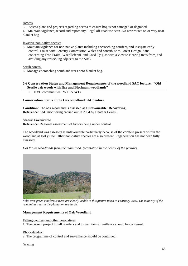
66
Access 3. Assess plans and projects regarding access to ensure bog is not damaged or degraded 4. Maintain vigilance, record and report any illegal off-road use seen. No new routes on or very near blanket bog. Invasive non-native species 5. Maintain vigilance for non-native plants including encroaching conifers, and instigate early
control. Liaise with Forestry Commission Wales and contribute to Forest Design Plans concerning Fron Fraith, Waenllefenni and Coed Tŷ-glas with a view to clearing trees from, and avoiding any restocking adjacent to the SAC.
Scrub control 6. Manage encroaching scrub and trees onto blanket bog. 5.6 Conservation Status and Management Requirements of the woodland SAC feature: “Old Sessile oak woods with Ilex and Blechnum woodlands”
• NVC communities: W11 & W17 Conservation Status of the Oak woodland SAC feature Condition: The oak woodland is assessed as Unfavourable: Recovering. Reference: SAC monitoring carried out in 2004 by Heather Lewis. Status: Favourable Reference: Regional assessment of factors being under control. The woodland was assessed as unfavourable particularly because of the conifers present within the woodland at Dol y Cae. Other non-native species are also present. Regeneration has not been fully assessed. Dol Y Cae woodlands from the main road. (plantation in the centre of the picture).
*The ever green coniferous trees are clearly visible in this picture taken in February 2005. The majority of the remaining trees in the plantation are larch. Management Requirements of Oak Woodland Felling conifers and other non-natives 1. The current project to fell conifers and to maintain surveillance should be continued. Rhododendron 2. The programme of control and surveillance should be continued. Grazing
67
3. Grazing should be reviewed with consideration of regeneration and woodland flora including the moss and liverwort interest. The management requirements of the Molinia grasslands, alkaline fens and Hamatocaulis vernicosus are similar and are therefore dealt with together here 5.7 Conservation Status for Features :
• Molinia meadows (EU Habitat Code: 6410) • Alkaline Fens (EU Habitat code : 7230 ) • Slender green feather moss Drepanocladus (Hamatocaulis) vernicosus (EU Species Code:
1393) Conservation Status of Molinia meadows Condition: The Molinia meadows SAC feature is assessed as Unfavourable: Declining. Reference: SAC monitoring in 2004 by Heather Lewis and Annie Seddon (Lewis 2004). Status: Unfavourable Reference: Regional assessment of factors not being under control. The targets for the extent were based on the extent mapped in the NVC surveys and during the monitoring in 2004. Therefore, the extent targets were met. The Molinia meadows failed to meet the targets for the habitat quality. Five monitoring plots were placed within different stands of both upland and lowland Molinia grassland at Tir Stent. Within these plots sample points were systematically recorded against quality attributes. On this basis 4 of those plots were judged to be in stands of habitat which were unfavourable. The majority of the points failed because the sward was too high or because scrub and tree species or bracken were recorded. The plot which passed was located in an area favoured by the grazing cattle. This result reflected the general impression of the site; the grasslands appeared to be rank with scrub invading. However, the sward remains species rich therefore, it is likely that a return to good condition could be relatively quick with the right management. Conservation Status of Alkaline Fens Condition: The alkaline fens is assessed as Favourable Maintained. Reference: SAC monitoring in 2004 by Heather Lewis and Annie Seddon (Lewis 2004). Status: Unfavourable Reference: Regional assessment of factors, especially grazing not being under control. Monitoring was carried out within Tir Stent which is the only management unit where alkaline fens is a key habitat. The targets for extent at Tir Stent were based on the NVC map adapted during the monitoring in 2004 (using up to date ortho-rectified aerial photographs and a high accuracy GPS in the field.). Therefore these targets were met. The stands of alkaline fen vegetation within the NNR (Unit 1) were not visited. Five stands of alkaline fen were chosen and assessed against quality attributes. The chosen stands represent the majority of the fen vegetation at Tir Stent therefore; the condition of the alkaline fen at Tir Stent can be established from assessing these stands. An assumption has been made that other stands of alkaline fen within Tir Stent will be in a similar condition to the assessed stands. • Survey SAC for stands of NVC M10 as this ‘alkaline fen’ community is very localised and
naturally small in area so previous surveys will not necessarily have mapped all of it.

68
Conservation Status of Hamatocaulis vernicosus Condition: The Hamatocaulis vernicosus is Favourable: Maintained. Reference: SAC monitoring and survey work carried out in 2004 by Heather Lewis, Simon Bosanquet and Annie Seddon. Status: Unfavourable Reference: Regional assessment of factors, especially grazing not being under control. The lower limit or target for the population extent was based on survey work carried out during the monitoring, providing a baseline, therefore, the target for population was met. The survey work revealed the population of Hamatocaulis to be much greater at Tir Stent than that previously recorded. The stands of habitat, which supported each colony, was assessed against quality criteria. Sufficient colonies were found to be in stands of good quality vegetation for the feature to be assessed to be in ‘good condition’. Management Requirements of Molinia grasslands, alkaline fens and Hamatocaulis vernicosus The management requirements below are set out in relation to Tir Stent which is the only management unit (9) where the Molinia meadows and Alkaline fens have a significant area and the only management unit where Hamatocaulis vernicosus is known to occur. Grazing The Molinia meadows (NVC M24 & 26), alkaline fens (NVC M10) and Hamatocaulis vernicosus SAC features are maintained by grazing management of the whole unit comprising extensive ‘other’ Molinia mire, neutral fen and other habitats including woodland, bracken and scrub. During the 2004 monitoring and in the years prior to this Tir Stent was considered to be under- grazed. Subsequent site visits by CCW staff have confirmed that this situation continues. Tir Stent is a common and few of the commoners exercise their commoners’ rights to graze livestock. Consequently the grazing levels are too low. The common is lightly grazed by sheep in winter and by cattle in summer but the exact grazing regime is unknown. 1. Review current grazing levels, discuss the issues with the commoners and draw up an
appropriate agreed grazing regime. This process is likely to include CCW advising more cattle or ponies graze Tir Stent in summer.
Hydrology and natural drainage A complex system of flushes and small water courses defines the vegetation distribution and mosaic at Tir Stent. The Molinia grasslands NVC M24 and M26 communities are characterised by species reliant on base rich flushing. The alkaline fens are maintained by base rich flushing in terms of both structure and species composition. H. vernicosus is found in areas with either flushing, up wellings from springs or a high water table which is at or slightly above the ground surface. It is restricted to ‘Slightly basic (moderately acidic)’ to ‘moderately basic’ conditions (from Hoylake, 1999). The preferred pH of the groundwater is probably in the range pH 6.0 to 7.0 but tolerances are not known. Alterations to the water chemistry or hydrological regime could therefore lead to a decrease in quality, or loss of the Molinia meadows or alkaline fens, or a decrease in the population or loss of colonies of H.vernicosus. The status of Tir Stent as a registered common, has probably protected the site from extensive ditching and artificial drainage. However, there are a small number of ditches on site along side the road and tracks. Small-scale water abstraction does occur on site for private water supplies. This is not considered to be affecting the feature currently. However, in 2004 there was some damage to SSSI features by the installation of new piping and it has become apparent that individuals with rights to abstract water from the common may not be aware of its status as SSSI and SAC.
69
Water draining off the adjacent forestry may affect the SAC features. Many of the trees have now been cleared, a process. 2. Review existing water abstraction points and check that individuals are notified as appropriate. 3. Assess plans and projects, including road and track works and forestry works adjacent, to ensure
that the hydrology and natural drainage of Tir Stent is not adversely affected. 4. Map and review the current pattern of artificial ditches to assess if they are having a significant
effect. Assess proposals regarding new ditching work or maintenance against the conservation objectives.
Access Physical damage or loss of vegetation can occur through access, however, it is also possible to interfere with the delicate system of flushes and watercourses, which support these habitats. Tir Stent has suffered from damage by trail bikes in the past, when temporary signs were erected warning trail bikers that riding the bikes on the common is a criminal offence. Quad bike tracks have also been noted. Orienteering events need to be assessed as a plan or project as there can be significant trampling from such events whereby vegetation is reduced to mud/bare ground at key points. 5. Review current situation, talk to commoners and take enforcement action as appropriate. Trees/Scrub encroachment Tir Stent supports a mosaic of open habitats including Molinia meadows, alkaline fens, flushes, heath, dry grassland which exists mainly in extensive glades within woodland, scrub and bracken. H. vernicosus is shade intolerant and therefore grows within open habitats are therefore, particularly vulnerable to scrub encroachment. Management should aim to maintain a balance between all of the different habitats at Tir Stent. Grazing helps to control scrub encroachment but rarely at the intensities appropriate here is able to stop tree and scrub encroachment. As Tir Stent has also had a period of under-grazing a programme of tree and scrub control is definitely required.
6. Tree and scrub species within and adjacent to stands of Molinia meadows, alkaline fens or flushes
and other open habitats supporting Hamatocaulis vernicosus should be removed as part of a programme of control on Tir Stent.
5.8 Conservation Status and Management Requirements of Marsh Fritillary Euphydryas, (Eurodryas, Hypodryas) aurinia (EU Species Code: 1065) Conservation Status of the marsh fritillary Condition: The marsh fritillary is assessed as Unfavourable: Declining. Reference: Monitoring work carried out by Andrew Graham (2005) and SAC monitoring carried out in 2005 by Heather Lewis. Status: Unfavourable Reference: Regional assessment of factors not being under control. Andrew Graham surveyed actual and potential Marsh fritillary habitat within a 2 km radius of Tir Stent and produced a landscape scale habitat condition map. Andrew Graham also carried out extensive web counts within this area. This included land within the Cadair Idris SSSI but outside of the SAC and undesignated land. Within Tir Stent he estimated 600 marsh fritillary webs within 18.9 ha of marsh fritillary habitat. This falls short of the target for 2000 webs. Eleven hectares (58%) were mapped as good condition habitat and approximately 7 ha (37%) of marsh fritillary habitat was found to be under grazed. This fell short of the target for 80% of the suitable habitat to be favourable which was in place during the monitoring in 2004. However, this
70
target has now been revised as part of the management planning to 10 ha of available habitat needed to in good condition. The marsh fritillary is recorded from other locations around Tir Stent- at Tyddyn Du, Bryn Castell and Tyn- sarn , the latter location being considered particularly good for marsh fritillaries. SAC Monitoring was minimal because of the work carried out in the same year by Andrew Graham. One monitoring plot was assessed for habitat quality. The plot was assessed within a stand of habitat which was mapped as a mosaic of good and under-grazed marsh fritillary habitat. It is also an important stand of the grassland since marsh fritillaries have been recorded in high numbers there in the past. Sample points were recorded systematically against the quality criteria for marsh fritillary habitat listed in the performance indicator for marsh fritillaries above. Only 21% of the sample points passed. Other stands of grassland were visited and photographed and visually assessed. The visual assessments were generally in agreement with the habitat quality map. Management Requirements for Marsh fritillary. Grazing The marsh fritillary Molinia grassland habitat with Succisa is maintained by grazing management of the whole unit comprising ‘other’ mire, neutral fen, woodland, bracken and scrub. Refer to 5.7 During the 2004 monitoring and in the years prior to this Tir Stent was considered to be under- grazed. Subsequent site visits by CCW staff have confirmed that this situation continues. Tir Stent is a common and few of the commoners exercise their commoners’ rights to graze livestock. Consequently the grazing levels are too low. The common is lightly grazed by sheep in winter and by cattle in summer but the exact grazing regime is unknown. 2. Review current grazing levels, discuss the issues with the commoners and draw up an
appropriate agreed grazing regime. This process is likely to include CCW advising more cattle or ponies graze Tir Stent in summer.
Metapopulation conservation In most cases the marsh fritillary occurs in metapopulations where dispersal from a core population during good years permits colonisation of nearby patches of habitat. Periodic extinctions and colonisations of patches can be tolerated as long as sufficient habitat overall is in good condition for breeding. Tir Stent form part of a core population of marsh fritillaries with adjacent units within the SSSI, Tyn- sarn, Tyddyn Du and Bryn Castell. Metapopulations exist outside of the SAC and SSSI within 2 km of the core population, at Cross Foxes and Tyddyn Garreg. Management should aim to protect the metapopulations by providing advice and responding to consultations regarding any development work or agricultural changes at the meta population sites.
• Where CCW is consulted on any development, works or alterations to the agricultural/habitat management within areas where the marsh fritillary has been recorded, advice should be given on the maintenance and improvement of the marsh fritillary habitat and conservation of marsh fritillary populations.
71
6. ACTION PLAN: SUMMARY This section takes the management requirements outlined in Section 5 a stage further, assessing the specific management actions required on each management unit. This information is a summary of that held in CCW’s Actions Database for sites, and the database will be used by CCW and partner organisations to plan future work to meet the Wales Environment Strategy targets for sites. Unit Number
CCW Database Number
Unit Name
Summary of Conservation Management Issues
Action needed?
1 000776 Unit 1 This unit forms the core of the Cadair Idris National Nature Reserve, managed by CCW. It is the aim of CCW to reduce grazing in this compartment of the NNR. However, CCW does not currently own the grazing rights. Footpath erosion is an ongoing problem within this unit however, this issue is being addressed with an ongoing programme of repair, but European funding for the Snowdonia Upland Path Partnership ends in June 2008. The sheer number of visitors to the summit plateau, combined with concentrated grazing, means that the sensitive heath communities there are under threat. Some small scale seeding of conifers happens at the eastern edge of this unit, adjacent to the mixed plantation. Rhododendron could potentially seed in from other units too. Vigilance to be maintained.
Yes
2 000777 Unit 2 This compartment of the National Nature Reserve is managed by CCW under a lease agreement. Open boundaries to the east and north mean that trespassing sheep graze the unit. The Ty Nant (Pony) path crosses this unit and it has therefore suffered footpath erosion. A programme of repair has been undertaken by Snowdonia Upland Path Partnership, but the European funding for this scheme comes to an end in June 2008.
Yes
3 000778 Unit 3 Forms part of Cadair Idris National Nature Reserve. The broadleaved wood is managed by CCW under a Nature Reserve Agreement. The mixed plantation, although not declared NNR, is owned and managed by CCW. The western, fenced area of the broadleaved woodland is currently ungrazed, and light grazing should be reintroduced for a period, to favour the lower plant interest, but conditions mean that no-one is willing to put sheep in. The eastern area is however overgrazed and needs a period of rest to allow regeneration of trees. The mixed plantation on the eastern bank of Nant Cadair is subject to a gradual programme of restoration to broadleaved woodland and open communities. The programme of rhododendron control needs to continue.
Yes
4 000779 Unit 4 Unit 4 to be absorbed into unit 1; Cadair Idris NNR. CCW currently have no control over grazing this area of ffridd. Management agreement to be negotiated or grazing rights purchased.
Yes
5 000780 Unit 5 This unit Cwm Rhwyddfor is managed under a Tir Gofal Agreement. The Tir Gofal Agreement should be reviewed by CCW.
No
72
Unit Number
CCW Database Number
Unit Name
Summary of Conservation Management Issues
Action needed?
6 000781 Unit 6 The grazing levels within this unit need to be assessed. It may be beneficial to extend the management agreement that exists over part of this unit, where stock is excluded and mature dry heath is grading to developing woodland. An area where it may be appropriate to consider it as a transition zone rather than a failing dry heath. One of the gullies in the ungrazed area has an infestation of Rhododendron ponticum. This should be cleared, and vigilance maintained for the palnt throughout.
Yes
7 000782 Unit 7 This unit is managed under Tir Gofal. The Tir Gofal Agreement should be reviewed by CCW.
No
8 000783 Unit 8 The grazing levels within this unit should be assessed. Yes 9 000784 Unit 9 Tir Stent is under grazed. It is common land and few
commoners are prepared to put grazing stock on the common. It is the aim of CCW to investigate who has commoners’ rights and to attempt to persuade them to put grazing stock onto the common. There have also been problems with trail bikes accessing the common in the past.
Yes
10 000785 Unit 10 This unit is managed under Tir Gofal. Review in future. No 11 000786 Unit 11 CL 137
The grazing levels within this unit need to be assessed Yes
12 000787 Unit 12 The grazing levels within this unit need to be assessed. Yes 13 000788 Unit 13 Will be included in the tenant's Tir Gofal agreement at 5
year review. CCW to advise on management. Yes
14 000789 Unit 14 The grazing levels within this management unit need to be assessed. This unit is under different ownerships (unfenced) and varies in condition. A management unit over part of it may be beneficial. Much of it is registered common land, and tenancies are uncertain. Trespass from this unit onto adjacent unit 2 -Cadair Idris NNR- is of concern.
Yes
15 000790 Unit 15 An ungrazed compartment, managed for nature conservation. The southern part of this unit is owned by the National Trust. The northern part of this unit is owned by CCW and managed as part of the undeclared Tanygader Nature Reserve. The northern edge of the unit is wooded and lies adjacent to a wider woodland (outside this SAC). It is considered appropriate to treat this unit as a transition zone where the heath communities are allowed to mature and develop a denser cover of native trees than other heathland units. Unplanned, illegal fires have been a problem on the northern edge in the past and liaison with neighbours is essential.
Yes
16 000791 Unit 16 This unit is currently managed under a Tir Gofal Agreement. Review in future.
No
17 000792 Unit 17 This management unit is managed under a Tir Gofal Agreement. Review in future. The Ty Nant (Pony) path crosses this unit, and the Snowdonia Upland Path Partnership has undertaken repair and maintenance. Funding for this partnership ends in June 2008 and the future is uncertain re path works.
Yes

73
Unit Number
CCW Database Number
Unit Name
Summary of Conservation Management Issues
Action needed?
18 000793 Unit 18 The grazing levels in this unit need to be assessed. Unconsented fires have been recorded on this unit in the past. Liaison with owner essential.
Yes
19 000794 Unit 19 This management unit is in relatively good condition. No 20 000795 Unit 20 This management unit is in relatively good condition. No 21 000796 Unit 21 This management unit is managed under Tir Gofal.
Review in future.
No
22 000797 Unit 22 The grazing levels and condition of the vegetation within this unit need to be assessed.
Yes
23 000798 Unit 23 The grazing levels need to be assessed in this management unit. Burning is also an issue here if burning continues to be a problem then further action may need to be taken.
Yes
24 000799 Unit 24 This management unit is currently managed under a Tir Gofal Agreement. Review in future.
No
25 000800 Unit 25 This management unit is managed under Tir Gofal. Review in future.
No
26 000801 Unit 26 This management unit is managed under a Tir Gofal Agreement. Review in future.
No
27 000802 Unit 27 Grazing levels need to be assessed. Yes 28 000803 Unit 28 There is a history of excessive burning within this
management unit. Action has already been taken with regard to the burning. If further unconsented burning occurs then further action needs to be taken. Grazing levels also need to be assessed.
Yes
29 000804 Unit 29 This management unit is in good condition. No 30 000805 Unit 30 This unit is in good condition. No 31 000807 Unit 31 Apparently grazed in association with unit 28, (but not
owned by the same farm) this unit has also suffered excessive, unconsented burning. Negotiation regard future management is in hand.
Yes
32 000808 Unit 32 Managed under a Tir Gofal agreement. Review in future. No 33 000809 Unit 33 Managed under a Tir Gofal agreement. Review in future.
No
34 000810 Unit 34 Managed under a Tir gofal agreement. Extensive grazing by cattle encouraged by CCW during 2007. Review in future. Pennant, the owners of this unit, also own the NNR unit 2 adjacent, and have undertaken to assist in managing stock trespass there from other units.
No
35 000811 Unit 35 Managed under a Tir Gofal agreement. Review in future. A boundary dispute re eastern boundary with NNR unit 1 remains unresolved.
Yes
36 000812 Unit 36 An ungrazed (or very lightly grazed) unit, described as being 'bryophyte enriched heath'. Another unit where it may be appropriate to consider it as a transition to developing woodland. Enquiries regard afforestation have been headed off in the past. Self-seeding conifers from the adjacent plantation should not be tolerated.
Yes
37 000813 Unit 37 Managed under Tir Gofal. Review in future. Vigilance required to control self-seeding conifers from the adjacent plantation.
No
38 000814 Unit 38 Managed under a Tir Gofal agreement. Review in future. No 39 000815 Unit 39 Managed under Tir Gofal, in association with unit 5, Cwm
Rhwyddfor. Review agreement in future. No
40 000816 Unit 40 This unit is suffering from over grazing. A diffuse pollution test needs to be carried out.
Yes
74
7. GLOSSARY This glossary defines the some of the terms used in this Core Management Plan. Some of the definitions are based on definitions contained in other documents, including legislation and other publications of CCW and the UK nature conservation agencies. None of these definitions is legally definitive. Action A recognisable and individually described act, undertaking or project of any kind,
specified in section 6 of a Core Management Plan or Management Plan, as being required for the conservation management of a site.
Attribute A quantifiable and monitorable characteristic of a feature that, in combination with
other such attributes, describes its condition. Common Standards Monitoring A set of principles developed jointly by the UK conservation
agencies to help ensure a consistent approach to monitoring and reporting on the features of sites designated for nature conservation, supported by guidance on identification of attributes and monitoring methodologies.
Condition A description of the state of a feature in terms of qualities or attributes that are
relevant in a nature conservation context. For example the condition of a habitat usually includes its extent and species composition and might also include aspects of its ecological functioning, spatial distribution and so on. The condition of a species population usually includes its total size and might also include its age structure, productivity, relationship to other populations and spatial distribution. Aspects of the habitat(s) on which a species population depends may also be considered as attributes of its condition.
Condition assessment The process of characterising the condition of a feature with
particular reference to whether the aspirations for its condition, as expressed in its conservation objective, are being met.
Condition categories The condition of feature can be categorised, following condition
assessment as one of the following2: Favourable: maintained; Favourable: recovered;
Favourable: un-classified Unfavourable: recovering; Unfavourable: no change; Unfavourable: declining; Unfavourable: un-classified Partially destroyed; Destroyed. Conservation management Acts or undertaking of all kinds, including but not necessarily limited
to actions, taken with the aim of achieving the conservation objectives of a site. Conservation management includes the taking of
2 See JNCC guidance on Common Standards Monitoring http://www.jncc.gov.uk/page-2272
75
statutory and non-statutory measures, it can include the acts of any party and it may take place outside site boundaries as well as within sites. Conservation management may also be embedded within other frameworks for land/sea management carried out for purposes other than achieving the conservation objectives.
Conservation objective The expression of the desired conservation status of a feature,
expressed as a vision for the feature and a series of performance indicators. The conservation objective for a feature is thus a composite statement, and each feature has one conservation objective.
Conservation status A description of the state of a feature that comprises both its condition and
the state of the factors affecting or likely to affect it. Conservation status is thus a characterisation of both the current state of a feature and its future prospects.
Conservation status assessment The process of characterising the conservation status of a
feature with particular reference to whether the aspirations for it, as expressed in its conservation objective, are being met. The results of conservation status assessment can be summarised either as ‘favourable’ (i.e. conservation objectives are met) or unfavourable (i.e. conservation objectives are not met). However the value of conservation status assessment in terms of supporting decisions about conservation management, lies mainly in the details of the assessment of feature condition, factors and trend information derived from comparisons between current and previous conservation status assessments and condition assessments.
Core Management Plan A CCW document containing the conservation objectives for a site
and a summary of other information contained in a full site Management Plan.
Factor Anything that has influenced, is influencing or may influence the condition of a
feature. Factors can be natural processes, human activities or effects arising from natural process or human activities, They can be positive or negative in terms of their influence on features, and they can arise within a site or from outside the site. Physical, socio-economic or legal constraints on conservation management can also be considered as factors.
Favourable condition See condition and condition assessment Favourable conservation status See conservation status and conservation status
assessment.3 Feature The species population, habitat type or other entity for which a site is
designated. The ecological or geological interest which justifies the designation of a site and which is the focus of conservation management.
Integrity See site integrity Key Feature The habitat or species population within a management unit that is the primary focus
of conservation management and monitoring in that unit.
3 A full definition of favourable conservation status is given in Section 4.

76
Management Plan The full expression of a designated site’s legal status, vision, features,
conservation objectives, performance indicators and management requirements. A complete management plan may not reside in a single document, but may be contained in a number of documents (including in particular the Core Management Plan) and sets of electronically stored information.
Management Unit An area within a site, defined according to one or more of a range of criteria,
such as topography, location of features, tenure, patterns of land/sea use. The key characteristic of management units is to reflect the spatial scale at which conservation management and monitoring can be most effectively organised. They are used as the primary basis for differentiating priorities for conservation management and monitoring in different parts of a site, and for facilitating communication with those responsible for management of different parts of a site.
Monitoring An intermittent (regular or irregular) series of observations in time, carried out to
show the extent of compliance with a formulated standard or degree of deviation from an expected norm. In Common Standards Monitoring, the formulated standard is the quantified expression of favourable condition based on attributes.
Operational limits The levels or values within which a factor is considered to be acceptable in
terms of its influence on a feature. A factor may have both upper and lower operational limits, or only an upper limit or lower limit. For some factors an upper limit may be zero.
Performance indicators The attributes and their associated specified limits, together with
factors and their associated operational limits, which provide the standard against which information from monitoring and other sources is used to determine the degree to which the conservation objectives for a feature are being met. Performance indicators are part of, not the same as, conservation objectives. See also vision for the feature.
Plan or project Project: Any form of construction work, installation, development or other
intervention in the environment, the carrying out or continuance of which is subject to a decision by any public body or statutory undertaker. Plan: a document prepared or adopted by a public body or statutory undertaker, intended to influence decisions on the carrying out of projects. Decisions on plans and projects which affect Natura 2000 and Ramsar sites are subject to specific legal and policy procedures.
Site integrity The coherence of a site’s ecological structure and function, across its whole area, that
enables it to sustain the habitat, complex of habitats and/or the levels of populations of the species for which it is designated.
Site Management Statement (SMS) The document containing CCW’s views about the management
of a site issued as part of the legal notification of an SSSI under section 28(4) of the Wildlife and Countryside Act 1981, as substituted.
Special Feature See feature. Specified limit The levels or values for an attribute which define the degree to which the
attribute can fluctuate without creating cause for concern about the condition of the feature. The range within the limits corresponds to favourable, the

77
range outside the limits corresponds to unfavourable. Attributes may have lower specified limits, upper specified limits, or both.
Unit See management unit. Vision for the feature The expression, within a conservation objective, of the aspirations
for the feature concerned. See also performance indicators. Vision Statement The statement conveying an impression of the whole site in the state that is
intended to be the product of its conservation management. A ‘pen portrait’ outlining the conditions that should prevail when all the conservation objectives are met. A description of the site as it would be when all the features are in favourable condition.

78
8. REFERENCES AND ANNEXES Averis A. B. G. & Averis A.M. (2000). Vegetation Survey of Cadair Idris National Nature Reserve, Gwynedd, Wales, August-September 1999. CCW North West Area Report CCW/NWA/6 Burn, A.M. 1982. Wales Field Unit Upland Vegetation Survey Site Report Number 11: Tan Y Gadair. Nature Conservancy Council, Bangor. Bosanquet, SDS, (2005) Hamatocaulis vernicosus (Bryophyta, Musci, Amblystegiaceae) on Tir Stent, Cadair Idris SSSI/SAC. CCW unpublished report. Evans, E.P, (1932) A study of certain plant communities in SW Meirionethshire. Journal of Ecology Vol 20, Pages 1-52. Edgell, M.C.R, (1969). Vegetation of an upland Ecosystem: Cadair Idris, Meirionethshire. Journal of Ecology. Part 57 pages 335-359. Fowles A. P. (2003) GUIDANCE NOTES FOR THE DEFINITION AND MAPPING OF HABITAT QUALITY FOR MARSH FRITILLARIES, Countryside Council for Wales, Plas Penrhos, Bangor, Gwynedd, LL57 2LQ. Graham, A. (2005) Marsh Fritillary Euphydryas aurinia Habitat & Larval Web Survey of the Tir Stent Area, 2005. Butterfly conservation. Grasse, J. (2002) Photographic record of notable plant sites and their access at Cadair Idris NNR. Voluntary Warden Report. CCW Llanfair. Holyoak,D T (1999) Status, Ecology, and Conservation of the Moss Hamatocaulis vernicosus in England and Wales. Unpublished report to CCW and EN, contract FIN/CON/VT9918 Jackson, P. K. & Yeo M. 1991. Wales Field Unit Upland Vegetation Survey Site Report Number 38: Cadair Idris. Nature Conservancy Council, Bangor. Yeo, M. And Guest D (1993) NVC Survey of Tir Stent. CCW report.